Implementation of a WebGIS for Nature and Adventure Tourism
by
Òscar Vidal Calbet
Dissertation submitted in partial fulfillment of the requirements for the Degree of Statistics and Information Management
in
Instituto Superior de Estatística e Gestão da Informação
of
Instituto Superior de Estatística e Gestão da Informação Univerisade Nova de Lisboa
ZoomAzores project:
Implementation of a WebGIS for Nature and Adventure Tourism
Òscar Vidal Calbet
Dissertation submitted in partial fulfillment of the requirements for the Degree of Statistics and Information Management
Dissertation supervised by
Professor Doutor Pedro da Costa Brito Cabral Mestre Francisco António dos Santos da Silva
ACKNOWLEDGMENTS
I would like to thank everyone who made possible the completion of this work. In particular:
First I want to thank my advisors Professor Pedro Cabral and the Mestre Francisco Silva. Because they gave me the opportunity to participate in this project and the splendid and effective guidance during the development of this work.
To the Associação Regional de Turismo dos Açores, because they believed in this project, giving all the support necessary to make it real.
To my friends and collages in the LabNT for all the good times, especially Hugo Martins for the courageous help and for introducing me to some of the technologies that I used. Tiago Lopes for having done a great job in preparing many of the geographic data that I used in this work.
Some virtual Open Source communities, I would like to especially thank the communities of GeoEXT, OpenLayers and PostGIS.
And finally, I want to thank especially Pearl May delos Santos dela Cruz, because she was always there, giving me motivation, technical help and emotional support. She made it all the time everything was better.
ABSTRACT
Nowadays, the Web offers new ways to make available information to users. This creates new ways and tools that can be used to make available tourist information and promotion of these destinations. The main objective this work is to develop a Web
application for the ZoomAzores project. This web application uses dynamic maps and user-generated content features, which are focused on make available useful information for the tourist and the promotion of Nature and Adventure Tourism (NAT) in the archipelago of Azores. The solutions encountered were always determined by the technologies used and from the point of view of tourists visiting the Azores, which frequently doesn’t know about the Azores territory. The ZoomAzores Web application has Geographic Information System (GIS) visualization and navigation capabilities on the Internet, turning it into a WebGIS. It also encompasses the principles of Web 2.0 providing functionalities such as the generation of contents by users. The existing link between the use of dynamic maps and Web 2.0 in the tourism promotion and travel planning tasks seems to be a solid reality putting up new opportunities for the business in tourism.
In this work, the development of the ZoomAzores WebGIS is based on the use of Open Standards (OS) and Free Open Source Software (FOSS). The use of OS is a key to the development of a WebGIS application able to interoperate with other systems and then use and consume Web Services (WS) that other systems can offer, concurrently enriching the data sources used. The FOSS technologies allow creates a more low cost solution without licensing cost software. This document exposes some design aspects in the system development and describes some functional and architectural features about the WebGIS ZoomAzores.
KEY WORDS
RESUMO
Atualmente, a Web oferece novas maneiras de tornar as informações disponíveis aos utilizadores. Isso implica novas formas e ferramentas que podem ser usados para tornar as informações turísticas disponíveis e fazer promoção destes destinos turísticos. O objetivo principal deste trabalho é desenvolver uma aplicação Web para o projeto ZoomAzores. Esta aplicação Web utiliza mapas dinâmicos e funcionalidades que permitem a geração de conteúdo por parte dos utilizadores, estes estão focados em tornar a informação disponível para o turista e para a promoção do Turismo de Natureza e Aventura (NAT) no arquipélago dos Açores. As soluções encontradas foram sempre determinadas pelas tecnologias
utilizadas e do ponto de vista dos turistas que visitam os Açores, que muitas vezes não sabe sobre o território dos Açores. A aplicação Web tem capacidades próprias dos Sistema de Informação Geográfica (GIS) como a visualização e navegação sobre informação
geográfica, sendo isto a traves da Internet, transformando-o em um WebGIS. Também engloba os princípios da Web 2.0 com funcionalidades como a geração de conteúdo pelos usuários. A ligação existente entre o uso de mapas dinâmicos e Web 2.0 na promoção do turismo e as tarefas de planeamento de viagens parece ser uma realidade sólida colocando novas oportunidades para o negócio do turismo.
Neste trabalho, o desenvolvimento do WebGIS ZoomAzores é baseado no uso de padrões abertos (OS) e Software Free Open Source (FOSS). O uso de padrões abertos é a chave para o desenvolvimento de uma aplicação WebGIS capaz de interoperar com outros sistemas e assim usar e consumir Web Services (WS) que outros sistemas podem oferecer, ao mesmo tempo enriquecer a fontes de dados utilizadas. As tecnologias FOSS permitem criar uma solução de custo mais baixo, sem custo de licenciamento de software. Este documento expõe alguns aspectos do projeto no desenvolvimento do sistema e descreve algumas características funcionais e arquitectónicas sobre o WebGIS ZoomAzores.
PALAVRAS-CHAVE
TABLE OF CONTENTS
INDEX OF FIGURES ... viii
INDEX OF TABLES ... x ACRONYMS ... xi INTRODUCTION ... 1 1.1. Overview ... 1 1.2. Objectives ... 3 1.3. Hypothesis ... 4 1.4. General Methodology ... 4 1.5. Thesis Structure... 5
2. TOURISM PROMOTION: WEBGIS AND WEB 2.0 ... 7
2.1. Introduction ... 7
2.2. Geotourism, Nature and Adventure Tourism ... 7
2.3. GIS and WebGIS Software Panorama ... 9
2.4. WebGIS for Tourism Promotion... 10
2.5. Web 2.0 and Tourism ... 12
2.6. Conclusions ... 13
3. INTEROPERABILITY, OPEN STANDARDS AND WEB SERVICES ... 15
3.1. Introduction ... 15
3.2. Interoperability and Open Standards ... 15
3.3. Web Services ... 18
3.4. Standard Protocols for WS: SOAP, WSDL and UDDI. ... 20
3.4.1. SOAP ... 20
3.4.2. WSDL ... 21
3.4.3. UDDI ... 21
3.5. The General Process of Hiring a Web Service ... 22
3.6. Standards for Geo Web Services ... 23
3.7. Open Source Software, Free Open Source Software and Proprietary Software .... 26
3.8. Conclusions ... 27
4. THE CASE STUDY: WEBGIS ZOOMAZORES... 29
4.2. Development Context ... 29
4.3. Why FOSS and OS? ... 30
4.4. General System Requirements. ... 31
4.5. Data Input and Pre-processing ... 32
4.5.1. Base layers from WMS ... 32
4.5.2. Pre-processed Base Layers ... 33
4.6. System Architecture ... 35
4.7. System Data Model ... 40
4.8. System Functionalities ... 41
4.9. Editing data ... 43
4.10. Tourist Interaction Example ... 47
4.11. An Interoperability Example: Flickr and ZoomAzores ... 51
4.12. Conclusions ... 54
5. CONCLUSIONS ... 55
5.1. Principal conclusions ... 55
5.2. Problems and Limitations ... 55
5.3. Future Work ... 56
INDEX OF FIGURES
Figure 1.1 Thesis structure schema ... 6
Figure 3.1 (a) User and Web application, (b) Web application and WS ... 18
Figure 3.2 Example of Web application consuming WSs ... 19
Figure 3.3 SOAP message structure ... 20
Figure 3.4 General process of hiring a WS. ... 23
Figure 4.1 Examples of base layers from WMS. A) Google Maps Roads, B) OpenStreetMaps, C) Google Maps Physical and D) Bing Maps Aerial ... 32
Figure 4.2 Pre-processed base layers. A) DEM and B) cartographic map ... 33
Figure 4.3 Workflow to create a DEM with GDAL ... 34
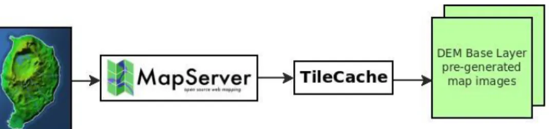
Figure 4.4 Work flow to create a cache ... 35
Figure 4.5 ZoomAzores system architecture as Client/Server style ... 36
Figure 4.6 ZoomAzores system architecture as 3-Tier style ... 36
Figure 4.7 ZoomAzores system architecture as SOA style ... 37
Figure 4.8 Architecture of the ZoomAzores system ... 38
Figure 4.9 Conceptual data model ... 40
Figure 4.10 Users profiles... 41
Figure 4.11 Context diagram ... 43
Figure 4.12 Content management functionalities ... 44
Figure 4.13 Interface to edit the fields from a service or activity ... 45
Figure 4.14 Editing spatial data with uDIG ... 45
Figure 4.15 Interface to edit the extra information ... 46
Figure 4.16 Interface to manage the files ... 47
Figure 4.18 (A) List which allows select activities, (B) activities showed on the map ... 48
Figure 4.19 Tool bar to browse on the map ... 49
Figure 4.20 Functionalities associated with the popup ... 50
Figure 4.21 Interoperability example ... 52
Figure 4.22 Request example for a Flickr WS ... 52
Figure 4.23 XML response example from a Flickr WS ... 53
INDEX OF TABLES
Table 1.1 Some WebGIS in tourism ... 11
Table 3.1 SDI’s examples ... 24
Table 3.2 Some OGC standards description ... 25
Table 3.3 Main FOSS WebGIS software and some of the OGC standards supported ... 26
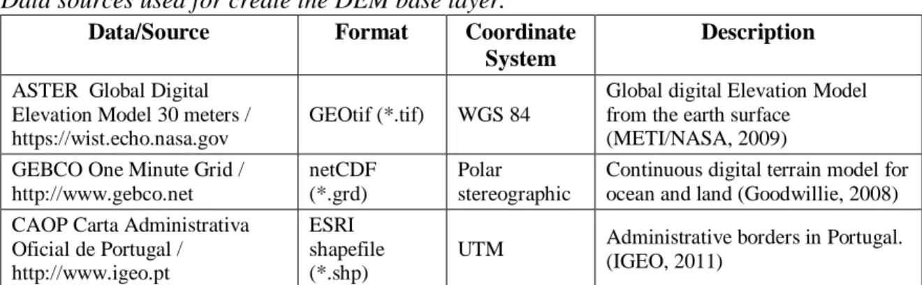
Table 4.1 Data sources used for create the DEM base layer ... 34
Table 4.2 Description of the tool bar functionalities of the map ... 49
ACRONYMS
API Application Programming Interface
ART Associação Regional de Turismo dos Açores
ASTER Advanced Spaceborne Thermal Emission and Reflection Radiometer CAOP Carta Administrativa Oficial de Portugal
DBMS Database Management System DEM Digital Elevation Model
ESHTE Escola Superior de Hotelaria e Turismo do Estoril FES Filter Encoding Standard
FOSS Free Open Source Software
GDAL Geospatial Data Abstraction Library GEBCO General Bathymetric Chart of the Oceans GIS Geographic Information System
GML Geographic Markup Language GPS Global Position System
GSDI Global Spatial Data Infrastructure Association HTTP Hypertext Transfer Protocol
ICT Information and Communication Technologies IDE Integrate Development Environment
IGEO Instituto Geográfico Português
ISEGI Instituto Superior de Estatística e Gestão da Informação KML Keyhole Markup Language
LGPL Lesser General Public License
METI Ministry of Economy, Trade and Industry NASA National Aeronautics and Space Administration NAT Nature Adventure Tourism
OASIS Organization for the Advancement of Structured Information Standards OGC Open Geospatial Consortium
OS Open Standards
OSGeo Open Source Geospatial Foundation OSI Open Source Initiative
OSS Open Source Software PHP Hypertext Preprocessor PPGIS Public Participation GIS
RDF Resource Description Framework SDI Spatial Data Infrastructure
SLD Styled Layer Descriptor SOA Service Oriented Architecture
UDDI Universal Description Discovery Integration URI Uniform Resource Identifiers
URL Uniform Resource Locator UTM Universal Transverse Mercator W3C World Wide Web Consortium WCS Web Coverage Service
WFS Web Feature Service WGS World Geodetic System WMC Web Map Context WMS Web Map Service
WS Web Service
WSDL Web Service Definition Language XML Extensible Markup Language
1.1. Overview
The developments in information and communication technologies (ICT) have transformed tourism in multiple ways in areas such as consumer demand and site management (Buhalis & Law, 2008; Guttentag, 2010). Varied inputs of information on destinations may play a major role on tourists’ choice and vacation planning (Decrop, 2006; Gursoy & McCleary, 2004) being the Internet a privileged tool for accomplishing this task (Buhalis, 2003; Buhalis & Law, 2008; Gretzel, Yuan, & Fesenmaier, 2000). E-Tourism represents the combined research of ICT and tourism, is changing the tourism sector rapidly calling for a constant adoption and integration of latest ICT developments into the tourism sector (Buhalis & Deimezi, 2004; Buhalis & Law, 2008). Since ICT developments are not developed directly by and for the tourism industry, both tourism researchers and professionals may be unprepared to adequately integrate these technologies into the sector (Guttentag, 2010).
Linking geography to tourism is an emergent field that is progressively gaining its own space in tourism research (Hall & Page, 2006, 2009; Lew, 2001). Many researchers have identified valuable contributions to tourism by applying GIS capabilities such as visualization, spatial analysis and mapping (Butler, 1992; Chen, 2007; Elliot-White & Finn, 1998; Hall & Page, 2009; Nielsen & Liburd, 2008). Nevertheless, GIS utilization has been far from its potential due to the high level of required expertise to deal with this type of systems and to the intensive data requirements (Hall & Page, 2009). The first objective of GIS is give the necessary information to help the decision makers in a decision making process when spatial information is evolved (Cabral, 2001) .
Tourism involves travel to a place where the tourist normally does not work or live (Richmond & Keller, 2003). The traveler, therefore, has limited spatial knowledge of the visited environment, and maps perform an essential function in the acquisition of spatial information about travel destinations. According to (Richmond & Keller, 2003), maps are
recognized as vital tools used throughout the entire tourism experience, from pre-holiday trip planning, through the actual vacation, to post trip analysis and holiday recollection.
In business where to sell experiences is the objective, the user-generated content systems has opened a new area of opportunities for the travel industry (Reactive, 2007). The Web 2.0 is one of the new technologies more used by consumers and are currently changing the traditional marketing methods in tourism business allowing the tourist relate their feedback of a product or experience (Au, 2010).
In this project, a GIS hosted on the Internet is developed, also known as WebGIS1, with the aim of promoting nature tourism in the Azores. This work is intended as a
continuation of the master's thesis in Science and GIS performed by Silva 2008. It is intended that the WebGIS developed reach a broad audience and can show all the
geographic information relevant allowing the dynamic maps to locate services and tourist resources more relevant in the Azores archipelago, as well as ancillary information relevant. Web 2.0 functionalities are included allowing the feedback from the users. The system will be directed at any potential tourist who is interested in carrying out activities related to nature, without having specific knowledge of GIS, so that it pursues the implementation of an intuitive and easy to use WebGIS.
This project is being developed by the "Instituto Superior de Estatística e Gestão da Informação" (ISEGI) and the "Escola Superior de Hotelaria e Turismo do Estoril " (ESHTE) for the "Associação Regional de Turismo dos Açores" (ART). The project is funded by the "Programa Operacional dos Açores para a Convergência"
(PROCONVERGÊNCIA2) and has an estimated duration of 2 years (2009-2011).
1
Web application that provides specific GIS functions through the Internet allowing the recovery, modification and analysis of geographic information.
2
The Azores Operational Programme for Convergence is a Reimbursed by the ERDF Operational
Programme for the programming period 2007-2013, included in the Community Convergence Objective, with implementation in the Azores, integrated in the Portuguese Strategic Reference Framework.
1.2. Objectives
The mission of the ZoomAzores project is the promotion of tourism in the Azores based on natural resources and NAT, but integrating information about all tourism products and services. According to (Richmond & Keller, 2003), "the purpose of tourism marketing is to create a particular image of the tourism destination in the minds of potential tourists, with the goal of enticing tourists to select the destination for a holiday". Maps are
indispensable vehicles for communicating spatial information and creating images of space and place (Zonn, 1990). Thus, the objective of the present work is to develop a WebGIS using Free Open Source Software (FOSS3) and Open Specifications (OS), which should carry out the tasks needed for accomplishing the objectives of tourist marketing. The WebGIS should not be dependent of software license cost, minimizing the price of the project and making it independent of license costs along the time and hence, only FOSS technologies are used making it sustainable for the local economy.
The main objective, which is to build a WebGIS to promote the tourism in Azores and the NAT in particular, is decomposed into more specific and functional objectives listed below:
Create an aesthetically appealing interface;
Identify and evaluate the FOSS technologies needed to develop a WebGIS; Make available useful and updated information for tourist promotion and travel planning for the end-users;
Create a back office allowing the content management for the administrators’ users.
Optimize performance issues in the WebGIS system;
Create a Web 2.0 component allowing feedback from users; and
Identify a way to link dynamically the tourist services with the companies offering these services.
3
Free and open-source software (F/OSS, FOSS) or free/libre/open-source software (FLOSS) is liberally licensed to grant the right of users to use, study, change, and improve its design through the availability of its source code (Shephard & Evans, 2005).
1.3. Hypothesis
The formulated hypotheses, which are the basis for this work, are the following: It is possible to use the Internet as a channel of communication and
promotion of tourism in nature, making use of dynamic and interactive maps to show to the potential tourists what are the possibilities a particular territory offers;
It is possible to use the user generated content, as text relating previous tourist experiences, for the promotion of tourist destinations.
It is feasible to use FOSS technologies, respecting the Open Geospatial Consortium (OGC)4 standards to develop WebGIS application for the promotion of nature activities for tourists.
1.4. General Methodology
One task included in the methodology of the development process is based in analyze the information needs of a potential tourist and implement a data model able to integrate this information needs in a WebGIS.
Analyze what kind the functionalities can help a potential tourist and identify which technologies can be used for the functionalities implementation integrated in a WebGIS.
The development of this project is based on web technologies. Regarding
programming languages, the PHP5 scripting language was used for the server side and the JavaScript6 language for the client side. For the software web development is used the integrate development environment (IDE) Aptana.
A database with spatial functions is implemented in PostgresSQL-PostGIS DBMS. For the web services, the Apache 2 and GeoServer are running in the server side. GDAL,
4
The Open Geospatial Consortium (OGC®) is a non-profit, international, voluntary consensus standards organization that is leading the development of standards for geospatial and location based services (Shephard & Evans, 2005).
5
PHP is a server side scripting language, designed for web development to produce dynamic web pages. 6
Geospatial Data Abstraction Library (GDAL, 2011) was used to process the raster data, create the base maps of the WebGIS. To deal with the spatial data features, to represent the tourist services, Quantum GIS software was used. All the system was developed and is running on Linux environment.
External Web Map Services and Web Services are used, such as the non
commercial and collaborative project OpenStreetMaps and commercial maps from Google, Yahoo and Google Earth. The geographic projection used is the Spherical Mercator.
The citations of the thesis are made using the rules of Journal of Tourism Management, which is one of the reference publications in the field of planning and management of travel and tourism.
All the structured diagrams which are illustrated in the form of figures were created using the Dia software.
1.5. Thesis Structure
This thesis is divided into 5 chapters. The first chapter presents an overview and contextualization of the master project outlining the main objectives and hypotheses.
In the second chapter, the application and the potential use of GIS in Tourism is discussed. The chapter presents how the GIS solutions can be an opportunity for Tourism. The importance of the Web 2.0 technologies in a tourism business and how it can be integrated in a WebGIS is addressed.
The third chapter is especially dedicated to Web Services (WS). It illustrates the role that the WS have on the development of an information system and benefits they entail. Also address the importance of defining and using Open Standards (OS) to the use of WS, to finally achieve interoperability between systems. A comparison between WS and Web Map Services (WMS) is done. It is also dedicated to GIS software panorama,
describing the best practices to choose FOSS technologies.
The fourth chapter is dedicated to the development and implementation of the ZoomAzores WebGIS. The chapter presents the system architecture, the conceptual data model, some system functionalities are explained. Also explain the process, as a work flow,
to pre-generate some map images to improve the system performance and finally illustrates an interoperability example.
The fifth and final chapter is dedicated to the conclusions, an overview to the problems found, limitations and future works.
The Figure 1.1, illustrates a schema with the thesis structure.
Figure 1.1. Thesis structure schema
Introduction Project overview Objectives Hypothesis
General methodology
Tourism promotion: WebGIS and Web 2.0 Tourism
GIS Web 2.0
Interoperability, Open Standards and Web Services Interoperability
Open Standards
Web Services & Web Map Services Open Source
Literature
Review
Application development and deployment
Chapter 1Chapter 2
Chapter 3
Main conclusions Conclusions
Problems and limitations Future work
Chapter 5
The case study: WebGIS ZoomAzores System Architecture
System Data Model System functionalities
2. TOURISM PROMOTION: WEBGIS AND WEB 2.0
2.1. Introduction
This chapter discusses the use of spatial information for tourism promotion and how the WebGIS can be a tool to help perform the tourism promotion of a specific geographical area.
The first part defines the Geotourism and NAT niches, which are based on a
sustainable model of tourist and are perfectly aligned with the objectives of the Portuguese public authority (Turismo de Portugal, I.P.) and the Regional Government of Azores (ALRA, 2008; Silva, Almeida, Pinto, Carvalho, & Pain, 2007; TP/MEI, 2007).
The second part on the other hand shows a brief GIS software panorama, how the web serves as a tool to spread the use of these GIS technologies, and the opportunity of consuming map services from outside sources and integrate it within a single WebGIS.
The third part discusses the lack of use of GIS technologies for tourism promotion and how these technologies can be integrated in the tourism business area, showing the information for promotion of the desired touristic area. Maps and touristic information are linked in a single web application.
The use of the Web 2.0 in tourism promotion and planning is discussed in the fourth part. Is pretended to show the opportunity that the Web 2.0 technologies are giving for a tourist business, showing some of the technologies underlying the Web 2.0 and how those can be integrated into a WebSIG.
2.2. Geotourism, Nature and Adventure Tourism
New trends in tourism have seen the evolution from mass tourism to sustainable tourism and the recognition of its associated activities, such as Geotourism (Hose, 2005). According to Hose, Geotourism encompasses the examination and understanding of the
physical basis of geosites7, together with their interpretative media and promotion.
Geotourism is defined by (National_Geographic_Society, 2011) as a tourism that sustains or enhances the geographical character of a place, its environment, culture, aesthetics, heritage, and the well-being of its residents. By the above definition, it can be extracted that for the practice of Geotourism, a great knowledge and understanding of the territory at different levels are required.
The NAT, according to Graham (2005), is an activity-based tourism which allows many players to enter what is now a highly specialized and lucrative market characterized by an enormous variety of products, ranging from whale watching trips in the Azores archipelago to guided ascents to the summit of Mount Everest, from cycling trips to surfing holidays, from canoeing to heli-hiking. Wilderness experiences have developed in a way that almost every adventure activity has been capitalized upon to provide some form of tourism experience (Shephard & Evans, 2005).
Geotourism and NAT niches are based on a sustainable model of tourism. Sustainable tourism is a form of tourism attempting to make a low impact on the environment and local culture, while helping to generate future employment for local people (WTO, 1998). Sustainable tourism is aligned with the objectives of The Regional Government of Azores who has assumed an environmental, economical and social sustainability paradigm as the regional tourism development model, which privileges quality in terms of the environment of the touristic destination and also in the facilities and touristic services (Silva, et al., 2007).
According Silva, the territory of the Azores has a strong geographical identity expressed by both the landscape and the natural and cultural heritage. In peripheral regions such as the Azores, recognized by its natural and cultural identity, the expansion of the alternative tourism paradigm is recognized as a contribution to sustainable development. (Silva & Almeida, 2010).
7
According Hose (2005), geosites are divided in 2 types: (1) Primary Geosites having
geological/geomorphologic features, either naturally or artificially and generally permanently exposed, within a delimited outdoor area that are at least locally significant for their scientific, educational or interpretative value. (2) Secondary Geosites having some feature(s) and/or item(s), within or on a structure or delimited area, of at least local significance to the history, development, presentation or interpretation of geology or geomorphology.
2.3. GIS and WebGIS Software Panorama
GIS is considered as a tool of excellence for handling spatial data and can be applied to various areas of knowledge (Longley, Goodchild, Maguire, & Rhind, 2005a; McMaster & Craig, 2002). These systems comprise a powerful set of tools for collecting, storing, retrieving at will, transforming and displaying spatial data from the real world (Burrough & McDonnell, 1998). Most of GIS systems, also known as Desktop GIS, run individually on personal computers and are seen as a technology restricted to a limited number of users that, as a rule, work for private or public companies or in research centers. Some well-known proprietary, and costly Desktop GIS are ArcGIS from ESRI (ESRI, 2010), Geomedia from Intergraph (Intergraph, 2010), Idrisi from Clark Labs (ClarkLabs, 2010), MapInfo (PitneyBowes, 2010), etc. Recently, some interesting free OSS (FOSS) solutions that do not require licensing appeared, making Desktop GIS technology more widespread. Examples include software packages such as Quantum GIS (QGIS, 2010), gvSIG (gvSIG, 2010), GRASS (Grass, 2010), uDIG (uDIG, 2010) and many others (Maptools, 2010; OSGEO, 2009). Regardless the type of licensing, all these sophisticated programs vary in their specific capabilities and require a significant investment in data acquisition and in trained professionals with strong background in GIS concepts to run them. Notwithstanding, these tools can be very useful, or even mandatory, for the preprocessing of geographical data to be integrated in the WebGIS.
The Internet development contributed to the growing importance of GIS in various areas opening new perspectives for people who need to use spatial data (Yang, Wong, Yang, Kafatos, & Li, 2004). Straightforward data sharing also became possible for Desktop GIS that can now use remote data services available through the Internet unlike previously where all data was only accessible locally. However, the most significant development has been the dissemination of GIS capabilities in the Internet through WebGIS. This combined technology of GIS and Internet enables the access to geographical data and to a myriad of analytical tools and different GIS services by using a simple web browser (Peng & Tsou,
2003). This synergy facilitates the process of finding and sharing spatial data and analytical tools, reaching a considerably larger number of users (Tang & Selwood, 2003).
WebGIS applications range from providing basic GIS functions, such as the ability to pan, zoom, turn data layers on and off and to query and view attribute data linked to mapped objects, to providing more refined techniques such as routing and point-in-polygon analysis (Drummond & French, 2008). WebGIS is also following latest Web developments like Web 2.0, which is a new generation of Internet services and technology (Deshpande & Jada, 2006; Nielsen & Liburd, 2008), that encourages more interaction between users (Boulos & Wheeler, 2007; Schuurman, Leight, & Berube, 2008). This evolution is leading GIS away from individual to group decisions known as Public Participation GIS (PPGIS) (Carver, 1999; Sakamoto & Fukui, 2004) and is also recognized as having an important impact in destination marketing (Pan, MacLaurin, & Crotts, 2007).
Some web mapping software options in the server side to publish spatial data on internet and concerning FOSS software are GeoServer (GeoServer, 2010), MapServer (MapServer, 2010) and Mapnik (Mapnik, 2011), and as proprietary software the most popular is ArcGIS Server (ESRI, 2010). On the client side and as FOSS projects we can find OpenLayers (OpenLayers, 2011) and GeoEXT (GeoEXT, 2011).
Many websites or applications such as Google Maps (Google, 2010b), Google Earth (Google, 2010a), OpenStreetMap (OpenStreetMap, 2010), Yahoo Maps (Yahoo, 2010) and Bing Maps (Microsoft, 2010) are providing worldwide geographical data such as detailed maps, satellite images and terrain maps. They also provide Application Programming Interfaces (API) that allow sophisticated users to combine their own geographically data and functions to produce mashups (Cheung, Yip, Townsend, & Scotch, 2008). This creates an opportunity for users to provide input about features or conditions at particular locations (Drummond & French, 2008).
2.4. WebGIS for Tourism Promotion
There are many case studies about WebGIS applications to various fields of studies such as site selection of radioactive waste disposal (Carver, 1999), disease mapping (Gao,
Mioc, Anton, Yi, & Coleman, 2008) and health care allocation (Schuurman, et al., 2008), to assist in the decision-making process to restore and preserve wetlands (Mathiyalagana, Grunwaldb, Reddyb, & Bloom, 2005), to test interoperability issues as means of GIS integration (Vckovsky, 1998), or to post location-specific notes and comments over Google maps similarly to the way users provide the content for Wikipedia (Wikimapia, 2010).
Applications of WebGIS in tourism are very rare, possibly due to the previously mentioned difficulties in using GIS technologies (Table 2.1). Most of them use their own cartography but some of them are already benefiting from Google API, making the interaction of the user easier when familiarized with Google mapping products.
Table 2.1.
Some WebGIS in tourism Name Area of interest Description URL Senderos de Aragon Aragon, Spain
Information about trails. GPS trails. http://senderos.turismodear agon.com Lisboa Interactiva Lisbon, Portugal
Leisure and cultural activities, e.g. restaurants, sport, theatres, etc. Recommended tours.
http://lisboainteractiva.cm-lisboa.pt
The Official Lithuanian Travel Guide
Lithuania Nature tourism activities and several information about tourism http://www.travel.lt/turizma s/map.do Switzer Provincial Park - Map Viewer Alberta, Canada
Information about nature tourism activities available in the William A. Switzer Provincial Park http://tpr.alberta.ca/parks/s witzer/parkmap_flash.html Travel Alberta Alberta, Canada
General tourist information. Activities, lodging, camping, etc. http://www.travelalberta.co m/TripPlanner/Pages/Defau lt.aspx?mrkt=Canada Germany the travel destination
Germany Touristic Tours, museums,
shopping, events, etc.
http://www.dzt-top50.de/index_neu.html/?l ang=en
Barbados Maps
Barbados Thematic maps based in Google API with touristic information.
http://barbados.org/maps.ht m
Places On Line
World Touristic points of interest such as hotels, restaurants, museums, entertainment, etc.
http://www.placesonline.co m/maps.asp
After performing a search of WebGIS sites for tourism promotion, it was noticed that even some web sites from countries where tourism is a major source of income, they make little use of maps, or at the most, very simple and static maps. This reveals the still existing lack of use of WebGIS for the promotion of tourism.
The ZoomAzores idea was first conceptualized by Silva (2008) who detected the lack of information for NAT activities in the Azores archipelago. After compiling relevant datasets, he argued that the use of WebGIS technology would be very important for this type of tourists that require a thorough geographical knowledge of visited areas (Silva, 2008).
Nowadays, the most used channel to promote tourist destinations is the Web
(Scottish-Parliament, 2002). However according a statistical study (SEREA, 2007), in 2001 only the 4,3% of tourists that visit the Azores used the Internet as a source of information for planning the journey, and in 2006 was the 14,3%. That denotes that in the case of
Azores, the use of internet as source of information for planning the trip is low in the tourist arriving to the Azores. But in general, the use of Internet gives great advantages in the tourism business, enabling the customer from anywhere to have much easier and direct access to a very large amount of up to date information than traditional printed media (Vasiljević, et al., 2009). WebGIS allows showing visual descriptions of desirable location, referencing where are the areas of interest, where to find the services needed linked with all the useful up to date information, which is going to help plan a trip. The ZoomAzores, focused on the adventure tourism niche, is giving the opportunity as well to give information that can be helpful to perform a desired activity on the field.
2.5. Web 2.0 and Tourism
Roland (2008) suggests that the Web 2.0 is becoming an important element in travel planning and buying. The term Web 2.0 is associated with web applications allowing participatory information sharing, interoperability and collaboration on the Internet, providing an opportunity for users to interact and collaborate with each other in a social media dialoged as creators of user-generated content.
Tourists normally try to use the holiday time efficiently, planning and getting information in multiple ways to reduce the risks during the decision process (Schegga, Liebrichb, Scaglionea, & Ahmadc, 2008) . Web 2.0 appears as a new source of information which allows interchange experiences between tourists, transforming the online decision process from an individual into a social activity (Au, 2010), and allowing consumers have more control over their travel decision making process (Cox, Burgess, Sellitto, &
Buultjens, 2008). This user-generated content means that marketers have less control over what messages reach their potential clients, but this does not necessarily mean that it will have negative ramifications as user-generated web sites can build brand loyalty and it can be a way of forming a relationship with the traveler (Cox, et al., 2008).
Nowadays traditional forms of marketing where content was created by the
marketer co-exist with the trend of the content generated by the consumer (Au, 2010). The former is relatively market-oriented and composed of merely static information. The latter on the other hand are basically opinions and suggestions based on past experiences of tourists, which are opportunities that the Web 2.0 offers to aid on the tasks of tourist promotion and travel planning. In fact, one of the objectives of the present project is to integrate Web 2.0 functionalities, user-generated content and collaborative evaluation, with the WebGIS, allowing sharing knowledge based on a previous experience from other tourists, and linking this knowledge with the services and activities which are located on the interactive map.
2.6. Conclusions
The NAT and Geotourism niches are sustainable forms of tourism and aligned with the objectives of The Regional Government of Azores (ALRA, 2008; Silva, et al., 2007). These forms of tourism require a good spatial knowledge of the terrain where thematic maps play as mediums of communicating geographic information.
There is a substantial group of software that can process and prepare the spatial information to be integrated within WebGIS. In this project, the WebGIS becomes the gateway for all tourist information related to a specific geographic area. It is possible to
integrate geographic information with the user-generated content and collaborative
evaluation, making the WebGIS a Web 2.0 collaborative information platform aimed at the promotion of tourist services and activities in nature. The use of the spatial information linked with the Web 2.0 appears to be a powerful combination of technologies to help in the planning decision process for holidays. It’s important to refer that to allow Web 2.0 technologies and functionalities work together with a WebGIS in the same system, the interoperability is needed. To achieve interoperability the use of open standards and the access to the source of the technologies is required.
3. INTEROPERABILITY, OPEN STANDARDS AND WEB SERVICES
3.1. Introduction
This chapter has more technological and technical approach. In the first section, it explains the definition of interoperability. It also discusses the interoperability as an information integration problem and scrutinizes what kind of tasks is needed to solve this common issue in the computer science area. It argues the importance to create and use Open Standards (OS) to integrate systems which are based on different technologies from different vendors, to achieve the much appreciated interoperability. In the second section, the Web Services (WS) are presented showing the role that these are playing to achieve the interoperability in distributed systems over Internet, and noting the WS importance
nowadays to build information systems. The third section is focused on the tree most important OS for the launch of the WS, explaining the tasks of these OS and how they are composed. The fourth part of this chapter shows the four basic steps involved in a general process to hire a WS, and showing the tree OS explained before in action. The fifth section is focused on the OS for a Geo-WS and makes a brief comparison with the non spatial WS. The most common OS used in a development of a WebGIS are listed making a brief description. Some server software for spatial data are showed and related with some of the OS that they are implementing. Because this is a project developed using Open Source technologies, in the sixth section is defined what this term means and explains the actually software licensing options. To conclude, the last section remarks the importance to use OS in the development of this project.
3.2. Interoperability and Open Standards
Interoperability refers to the capability of autonomous systems to exchange data and to handle processing request by means of a common understanding of data and requests (Doyle, Han, Weakliam, Bertolotto, & Wilson, 2004). Therefore interoperability allows the
communication between open systems using common communication infrastructures, a public applications programming interfaces, and a common objects definition to transport them across networks (Longley, Goodchild, Maguire, & Rhind, 2005b). Achieving interoperability creates new challenges for many areas of computer science where the concept of information integration is behind (Stuckenschmidt, Wache, Vogele, & Visser, 2000). According Heiner there are three different tasks for the information integration:
1. Syntactic Integration: This problem concerns the level of data types and data structure. To solve this problem, standards are used to integrate different
information sources. Standards created using markup languages such as XML8 are gaining importance allowing the definition of a data structure based on a hierarchy model enabling the representation of any conceptual data model that is coming from other sources as a database system.
2. Structural Integration: This problem appears when there are numerous data sources in the same system and normally solved by mediator systems, defining mapping rules between different information structures. The task of this mediator or middleware is to reformat the different data structures coming from numerous sources to a new
homogeneous data structure.
3. Semantic Integration: This is the most complicated task that presents a real challenge. It focuses on the meanings of the data and uses semantic information to aid in the translation of data in one data model to another data model. To solve this problem, there are several approaches from different authors (Heflin & Hendler, 2000; Noy, Doan, & Halevy, 2005; Richard & Geert-Jan, 2001; Stuckenschmidt, et al., 2000; Wang, Lu, Zhang, Miao, & Zhou, 2009) . According to these authors, ontology and Resource Description Framework9 (RDF) can be used to deal with this problem.
Now, addressing the integration data between independent systems in a web environment, where heterogeneous data is coming from distributed sources and the
8
Extensible Markup Language (XML) is a simple, very flexible text format. Originally designed to meet the challenges of large-scale electronic publishing, XML is also playing an increasingly important role in the exchange of a wide variety of data on the Web and elsewhere (W3C, 1998).
9
RDF is a standard model for data interchange on the Web. RDF has features that facilitate data merging even if the underlying schemas differ, and it specifically supports the evolution of schemas over time without requiring all the data consumers to be changed (W3C, 2004b)
interoperability is needed, the independent systems must be able to use a common and universally available set of web services accessible thought networks communication (Doyle, et al., 2004). The web services must allow exchange data and handle requests between the independent systems (Doyle, et al., 2004). This web services must use a common formal language, XML, and common model representation throw XML schemas. The XML schemas is a standard that provide a means for defining the structure, content and semantics of XML documents (W3C, 2001).
According Becker (Becker, 2007) and concerning interoperability, standards are the key to allow definition of: (1) layered reference architecture and clarifying the boundaries between standards in each layer, (2) generic services for information exchange and (3) profiles for the services and semantics for specific information exchanges between business functions.
Open Standards are programming rules and guidelines for implementing interface and/or protocols that enable interoperability between systems which must be considered in WebGIS application development (Moreno-Sanchez, Anderson, Cruz, & Hayden, 2007). Open Standards arising from the collaboration of interested parties results in a consensus on specifications for implementing common requirements (Sliman, 2002). Sliman emphasizes that Open Standards means openness in both the standards setting process as well as access to the specifications. According Sliman and Schwartz (Schwartz, 2003) the use of Open standards helps to consolidate competing standards, increasing the aggregate pool of resources available for using them without be dependent of a specific vendor.
The World Wide Web Consortium (W3C) was funded in 1994 and is an
international community that develops standards to ensure the long-term growth of the Web (W3C, 2011). One of W3C's primary goals is to make available the benefits of the Web, enabling human communication, commerce and opportunities to share knowledge, making it available to all people, whatever their hardware, software, network infrastructure, native language, culture, geographical location, or physical or mental ability.
3.3. Web Services
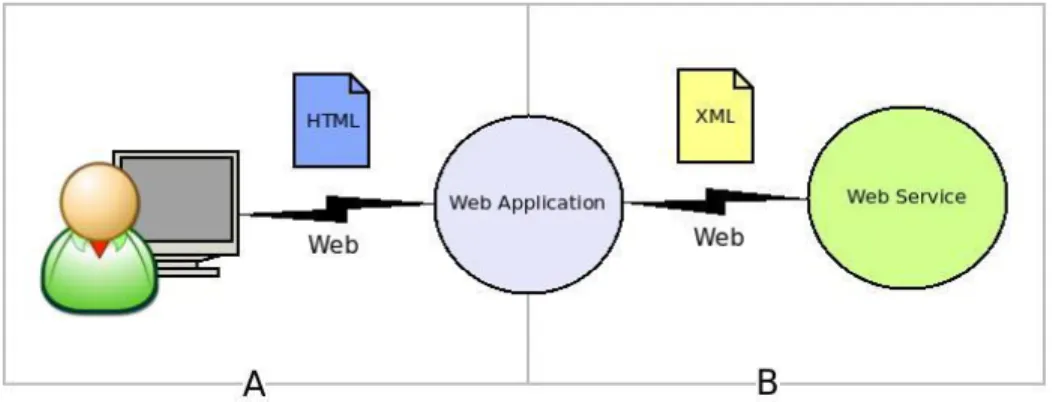
The initial success of the Web in the 90s is attributed to the fact of provide distributed and referenced resources, textual information, with a Uniform Resource Identifiers10 (URI) to interconnect them globally (Figure 3.1. A) (Muschamp, 2004). When the web services emerged, the web resources that are initially limited to be textual or multimedia information can now be a software application providing a specific service (Figure 3.1. B) (Davies, Fensel, & Richardson, 2004; Muschamp, 2004).
Figure 3.1. (a) User and Web application, (b) Web application and WS
Web Services are software components that can be located through URI addressand invoked from others software components, which are allocated over the same network (Muschamp, 2004; Richardson, 2008). Another characteristic of a Web Service is the fact that it can describe it self, allowing other software components understand the
functionalities it offers and how to access these functionalities. The principal objective of WS is to provide interoperability between applications that have been built on different systems and can be using different technologies from different vendors (Davies, et al., 2004; Mockford, 2004).
A WS can make available a variety of products, coming from database systems, application servers and standard applications. For example (Figure 3.2.), a WS can be an
10
The URI is a single global identification system, providing identification that is common across the Web (W3C, 2004a).
application that when a tourist is in a specific online booking web application allowing make a reserve in different hotels, one WS can have the task to check if the credit card number for this specific user is correct and is still able to be used. Another WS can handle the task to check if there are available rooms in the specific hotel for some specific days and giving back the result of what rooms are available and which are the prices.
Figure 3.2. Example of Web application consuming WSs.
The WSs are giving a new service-oriented architectural approach, based on the notion of building applications by discovering and orchestrating network-available services (Harrison & Reichardt, 2001) . Daum (Daum & Merten, 2003) refers that the WSs have become an integral aspect of modern system architecture. A system architecture based on services is called SOA (Service Oriented Architecture). It’s an architectural style for building software applications that use services available in a network such as the web (Mahmoud, 2005). In SOA systems, a service is an implementation of well-defined business functionality, and it can be consumed by clients in different applications or business processes. A system based on SOA must be focused on resolving pressing business challenges (Marks & Bell, 2006).
At the end of 2000, product from the collaboration and effort of well-known companies such as IBM, BEA Systems, Oracle, Microsoft and HP, to define the standards needed for create and use an interoperable Web Services, and finally this basic standards
and technology appears with SOAP11, WSDL and UDDI (Harrison & Reichardt, 2001; Muschamp, 2004). The common language for all this technologies is the XML.
3.4. Standard Protocols for WS: SOAP, WSDL and UDDI.
The present section is dedicated to explain how this three standards works and the roll that these play with the WS. How we saw before, a WS should be able to be invoked, describe itself and be located. Each of these characteristics is directly related with one of these standard technologies in the way that; SOAP allow a service to be invoked, WSDL provides the description of the service and UDDI is the protocol for locate a WS
(Muschamp, 2004).
3.4.1. SOAP
SOAP is a standard protocol for accessing and invoking a WS. The SOAP protocol provides the definition rules to create a XML message, it used for exchanging structured information between software components over the internet. A SOAP message is composed by different sections and it can be extended and adapted to define any information that is pretended to transfer. The basic components of a message are the envelope, header/s and body (Figure 3.3). In the header section is where usually is defined the URI that identify the WS which is invoking the message. The SOAP message can use different protocols to be transported, being HTTP the most currently used.
Figure 3.3. SOAP message structure
11SOAP used to stand for ―Simple Object Access Protocol‖ in version 1.1, but with the release of SOAP
3.4.2. WSDL
The WS Definition Language WSDL is an XML-based language for describing the functionalities of the WSs and how locates it. The WSDL language gives a detailed
description of the WS. This description is divided in two parts, concrete and abstract description:
1. In the concrete description is defined the address of the WS which is typically represented by a HTTP URL and defines the implementation details necessary to access the service. In this description is located the information needed to create a SOAP message.
2. In the abstract description defines the operations that can be performed, the messages that are used to perform the operation and what type of data are used by specifying which XML-schemas is using the WS.
3.4.3. UDDI
The Universal, Description, Discovery and Integration (UDDI) define a standard method for publishing and discovering WS. The functional purpose is the representation of data and metadata about WSs in a service repository. It offers a standards-based mechanism to classify, catalog, and manage WS, so that they can be discovered and consumed by other applications (OASIS, 2006). This standard was created by OASIS (Organization for the Advancement of Structured Information Standards) which is a not-for-profit consortium that drives the development, convergence and adoption of open standards for the global information society. UDDI defines a set of public services that can be used directly by applications and services to interact with UDDI data, using a specific Application Public Interface. This API allows publish, update, discover services and get the information details in automatic way. Actually there are more service repositories available on internet some examples are webservicelist and service-repository.
3.5. The General Process of Hiring a Web Service
This section aims to describe the general process of hiring a WS (Figure 3.4) and observing how the three basic standards, that propel the use of WSs, are playing in this process. The content and terminology is based in the document WS Architecture (W3C, 2004c) but making a simplification of the possible cases that the process can be involved. The description is going to show the four required steeps in this process of hiring a WS and using a generalized and simplified model of the process.
1. The requester and provider entities become known to each other. This step can be initiated by the requester or the provider of the WS. In a typical case is the requester who is going to initiate the process. Two scenarios are possible; (1) the requester entity knows already where the service is, if not (2) the requester entity may use a discovery service, like UDDI, to locate a suitable service description via an associated functional description, either through manual discovery or autonomous selection.
2. The requester and provider entities agree on the service description defined in a WSDL document and semantics that will govern the interaction between the requester and provider agents.
3. The service description and semantics are realized by the requester and provider agents. This means create a software component to make the request and interact with the WS provider, using some programming language or other technology. The technology used to interact with the WS is independent with the technologies used to implement the WS.
4. The requester and provider agents exchange SOAP messages, thus performing some task on behalf of the requester and provider entities. The WS is invoked from the requester agent using a SOAP message to the provider agent.
Figure 3.4. General process of hiring a WS. Adapted from (W3C, 2004c)
3.6. Standards for Geo Web Services
Open Standards for geospatial and location based services are defined by the Open Geospatial Consortium (OGC, 2009) and their use is of paramount importance for granting information portability between different applications, i.e., interoperability (Vckovsky, 1998). OGC was founded in 1994 and consists of an international consortium of
companies, government agencies and universities that work on concepts and techniques that help to provide the previously mentioned interoperability. This organization has developed implementation specifications for several WSs, i.e. computing processes provided remotely using the Internet, that offer a standardized way for users to search for maps and geoprocessing sources over the Web from different map servers and different vendors.
The definition of Geo-WS standards was previous to the definition of the standards for WS, and because of that the Geo-WS are not based on WSDL, UDDI and SOAP
standards (Araújo, 2005). To invoke a Geo-WS is used the HTTP protocol with GET or POST operations, without need of a SOAP message. To get the description of a Geo-WS is used the common operation GetCapabilities, this operation is implemented in all the Geo-WS and is the equivalent of a Geo-WSDL description for a non spatial Geo-WS. For the discovery and view of Geo-WS there is the Spatial Data Infrastructure (SDI). A SDI is defined by the Global Spatial Data Infrastructure Association12 (GSDA, 2009) as a “coordinated series of agreements on technology standards, institutional arrangements, and policies that enable the discovery and facilitate the availability of and access to spatial data‖. A specific SDI initiative always refers to a specific geographic area (Table n) and a hierarchy level (Ex. Local, regional, national...).
Table 3.1. SDI’s examples
SDI name Geographic area IDEiA Azores SNIG Portugal GDI-DE German INSPIRE Europe ASDI Australia NSDI EEUU GSDI Global
In a WS catalogue based on UDDI standard, the WS functionality normally refers a specific business process belonging to some business area, while in a SDI catalogue the Geo-WS can refer a specific thematic data (roads, land use, interest points…) belonging to a specific geographic area.
12
The GSDI Association is an inclusive organization of organizations, agencies, firms, and individuals from around the world. The purpose of the organization is to promote international cooperation and
collaboration in support of local, national and international spatial data infrastructure developments that will allow nations to better address social, economic, and environmental issues of pressing importance.
The OGC is the institution working in defining new OS to solve the interoperability need for spatial data. In Table 3.2 are identified and described the most important standards concerning WSs for spatial data that can be adopted in WebGIS development.
Table 3.2.
Some OGC standards description (OGC, 2009) Standard Description
Web Map Service (WMS)
Defines the rules to request geographic layers of an area of interest, and obtains, as result, one or more geo-registered map images (returned as JPEG, PNG, etc.) that can be displayed in a browser.
Web Feature Service (WFS)
Provides the rules to request some geographic layers of an area of interest, but the response consists of the geographic features themselves as vector data. The transactional Web Feature Service (WFS-T) allows creation, deletion, and updating of features.
Geographic Markup Language (GML)
Extensible Markup Language (XML) grammar for expressing geographical features. Serves as a modeling language for GIS as well as an open interchange format for geographic transactions on the Internet.
Web Map Context (WMC)
Specifies how a specific grouping of one or more maps coming from one or more WMS can be described in a portable format for storage, use and reuse within and between clients
Keyhole Markup Language (KML)
XML standard language for expressing geographic annotation and visualization on existing or future web-based online and mobile maps (2d) and earth browsers (3d).
Web Coverage Service (WCS)
Defines a standard interface and operations that enables interoperable access to geospatial coverages.
Styled Layer Descriptor (SLD)
Defines an encoding that extends the WMS standard to allow user-defined symbolization and coloring of geographic feature.
Filter Encoding Standard (FES)
Defines an XML encoding for filter expressions which logically combines constraints on the properties of a feature in order to identify a particular subset of features to be operated upon.
Currently, there is a wide range of options for WebGIS based on FOSS which are compliant with OGC OS. This is a critical factor of success if one wants to consider
the application keeping it open to the integration of new features and services. Most
important FOSS WebGIS projects have all more than one standard compliancy (Table 3.3). Table 1.3
Main FOSS WebGIS software and some of the OGC standards supported Standard Software WMS WFS WFST GML WMC KML WCS SLD FES MapGuide (Autodesk, 2010) X X GeoServer (GeoServer, 2010) X X X X X X X X X MapServer (MapServer, 2010) X X X X X X X Mapfish (MapFish, 2010) X X X X X
In this project is used the software GeoServer to create the Geo-WS. GeoServer is a software server written in Java that allows users to share and edit geospatial data. Designed for interoperability, it publishes data from any major spatial data source using a OGC standards (GeoServer, 2010). GeoServer is an Open Source Geospatial Foundation (OSGeo) project. OSGeo is a not-for-profit organization whose mission is to support and promote the collaborative development of open geospatial technologies and data (OSGEO, 2009). The present project is implemented using only Open Source technologies, being it one of the requisites to guaranty zero license software cost.
3.7. Open Source Software, Free Open Source Software and Proprietary Software
Currently, there are a large number of options concerning WebGIS software that can be applied to the tourism sector. These range from those provided by software vendors to the ones developed by groups dedicated to research and not all of them implement OS
which may compromise interoperability issues. As a result the decision of choosing what software to use may not be easy.
According to the Open Source Initiative (OSI), Open Source Software (OSS) does not mean just access to source code but also full compliance to criteria such as free use and distribution of the program for any purpose, its modification without the need for execution of an additional license, among others (OSI, 2009). This term does not mean exactly the same as free software because some licenses are considered too restrictive (GNU, 2009). The term FOSS refers to ―software with permission for anyone to use, copy, and/or distribute, either verbatim or with modifications, either gratis or for a fee‖ (GNU, 2009). This also means that the source code must be available. The terms ―freeware‖, i.e. software that can be redistributed but not modified, and ―shareware‖, i.e. software that can be redistributed but requires licensing if someone wants to continue using it, should not be confused with free software (GNU, 2009). Examples of FOSS for WebGIS include
MapServer (MapServer, 2010), GeoServer (GeoServer, 2010) and many others (Maptools, 2010; OSGEO, 2009)
Non-free, or proprietary, software is any software where any use, redistribution or modification is forbidden or requires authorization (GNU, 2009). Example of proprietary WebGIS software packages include ArcGIS Server (ESRI, 2010), Geomedia WebMap (Intergraph, 2010) and many others. An example of a non-free open source WebGIS software is MapGuide Open Source from Autodesk (Autodesk, 2010) which is licensed under the LGPL (Lesser General Public License). This type of license grants permission to copy and distribute verbatim copies of this license document, but changing it is not allowed (GNU, 2009).
3.8. Conclusions
Using WS is possible extend functionalities of a system, integrate it with other business areas and increase the flexibility to adapt the information system to a changing business model. The whole system architecture can be based on many WS and named as SOA architecture. The need of creating and using open standards arises from the concept of
interoperability, where the objective is to create a flow of information to get interaction between different systems. The definition of standards comes from neutral organizations and sometimes with the collaboration of different vendors.
The chapter showed some of the technique concepts which are applied in the
development of the WebGIS. The use of WSs in the development of this project is used and they play an important role in the system giving the opportunity to get some external
collaborative data as the maps from OpenStreetMap project or the several pictures available in the Flickr system. Without the use of OS the ZoomAzores WebGIS will be a close system and lost the opportunity to consume potentially useful external data, which is increasing the value of the system.
4. THE CASE STUDY: WEBGIS ZOOMAZORES
4.1. Introduction
This chapter is dedicated to the description of the ZoomAzores system. The first section gives some context information about the ZoomAzores project development. A justification of why are used FOSS technologies and the OS is discussed in the second section. The third section delineates some general system requirements that define the philosophy of development and conditioning system design decisions to take. The fourth section goes directly to explain the system architecture, revealing that is based on different architectural styles, explaining each of the technologies and parts of the system and how they relate to each other. The fifth section illustrates the conceptual data model that is behind of the system explaining each of the entities of which is composed. The sixth
section identifies the principal functionalities of the system, shows a UML context diagram, later is explored the content management related functionalities, discomposing this in some user cases with the interfaces designed for them, also shows what kind of interactions can have a potential tourist with the ZoomAzores. The seventh section exposes some base layers used in the WebGIS and explains how digital elevation model was created and processed as tile cache images to later be used as a one of the base layer in the WebGIS. In the eighth section we can see an interoperability example, between Flickr and ZoomAzores. To conclude, the last section denotes the importance to choose a FOSS technology with an active online community, which can provide the necessary support.
4.2. Development Context
The implementation of ZoomAzores project was initiated in January 2010. With an estimated 2 years time duration, it is still currently being developed at the Institute of Statistics and Information Management (ISEGI) and the School of Hospitality and Tourism Estoril (ESHTE) for the Association of the Azores Regional Tourism (ART). In ISEGI, the
mains tasks are to define the system architecture, develop the WebGIS application and elaborate the final user’s manual. In the ESHTE, the mains tasks, as GIS and tourism specialists, are to identify, collect, build and organize the necessary spatial, multimedia and textual information. Both teams have regular meetings to show the results and define the new tasks to execute. This document is focused in the technical aspects of the WebGIS development.
4.3. Why FOSS and OS?
The decision of using FOSS and OS to develop the ZoomAzores WebGIS was taken considering two vectors: (a) the need of ensuring long-term economic sustainability without depending of software license costs and (b) the need of ensuring a scalable and
interoperable solution that is able to communicate with different software platforms and to integrate different data formats. The former is addressed by the use of FOSS that suits the ZoomAzores project that has a limited execution time and economic financial support. The latter is granted by the use of interoperable standards, i.e. OS, that allow the visualization, distribution, and processing of geographic data from different software and devices (Vckovsky, 1998).
In the OSS technologies panorama, there are different alternatives available for each of the module that can be used, hence the first task consists of identifying what modules are available and which can be successfully used. A good practice to choose the right OSS technologies is to use the criteria suggested by in the form of questions (Ramsey, 2007): (a) Is it clear who the core development team is? (b) Is the software modular? (c) How wide is the development community? (d) How wide is the user community? Positive answers to these questions indicate a healthy and mature OSS project which provides a greater degree of confidence in its use (Moreno-Sanchez, et al., 2007).
4.4. General System Requirements.
To develop the WebGIS and accomplish the objectives of tourist promotion, we focused on seven general and initial system requirements:
1. The map information should be clear. Since the web application aims sporadic users looking for a travel destination, it was decided that the cleanness of the interface and the data organization should be a requirement;
2. The map should contain useful information. Because one of the objectives is to support the planning trip process, the information must be useful to allow taking the right decisions;
3. The map should be aesthetically pleasant. For the reason that the main objective is to perform the promotion of the Azores as a tourism destination, the map which is representing the Azores area must be aesthetically appealing, transmitting good sensations and opening the curiosity about the area;
4. The system should be user-friendly. Because the system is designated to sporadic users as the potential tourist and tourism professionals without technologic background required;
5. The system should have long-term economic viability. Since the economic budget for the project is limited and we are looking for long-term durability of the project, we must find a way to not live the project dependent of the licenses payment;
6. The system should allow the interoperability of data and services. Since we need ensuring a scalable and interoperable solution that is able to communicate with different software platforms and to integrate different data formats; and
7. The system should have a great performance. Here is important to refer that the performance in a WebGIS systems is a important issue to overcome (Yang, et al., 2004). To keep the users interested we need improve the system performance to deliver the data in a reasonable time while they are looking between several destinations options.
4.5. Data Input and Pre-processing
This section is focused on the spatial data that the system is using. In this case, it is possible to make the distinction between two different kinds of data. The first are the spatial entities, which are represented by the kind of geometry like point, line or segment. These can symbolize various themes such as tourist services or activities. The second are the background map images which are oriented to give a spatial context, known as base layers in GIS terminology. These maps can show different kinds of contexts focused on for an instance terrain elevation or aerial images.
4.5.1. Base layers from WMS
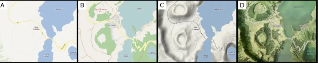
Some base layers used in this project are coming from WMS. In the Figure 4.1 we can see some examples of base layers coming from a WS used in the ZoomAzores
WebGIS. For example the base layer A is coming from Google Maps and the B is coming from OpenStreetMaps. The Figure 4.1 is representing the same area in the four maps, but each map gives different kind of information. The WebGIS is allows select which base layer we want to see, only one at the same time, depending of what kind of information wee need to use as context.
Figure 4.1. Examples of base layers from WMS. A) Google Maps Roads, B) OpenStreetMaps, C) Google Maps Physical and D) Bing Maps Aerial.
The entire base layers coming WMS are using the same projection Spherical Mercator, and the same pre-defined zoom levels. That obliges to use the same projection