HESSD
7, 9023–9042, 2010Exchange between a river and groundwater
E. Hoehn and A. Scholtis
Title Page
Abstract Introduction
Conclusions References
Tables Figures
◭ ◮
◭ ◮
Back Close
Full Screen / Esc
Printer-friendly Version Interactive Discussion
Discussion
P
a
per
|
Dis
cussion
P
a
per
|
Discussion
P
a
per
|
Discussio
n
P
a
per
|
Hydrol. Earth Syst. Sci. Discuss., 7, 9023–9042, 2010 www.hydrol-earth-syst-sci-discuss.net/7/9023/2010/ doi:10.5194/hessd-7-9023-2010
© Author(s) 2010. CC Attribution 3.0 License.
Hydrology and Earth System Sciences Discussions
This discussion paper is/has been under review for the journal Hydrology and Earth System Sciences (HESS). Please refer to the corresponding final paper in HESS if available.
Exchange between a river and
groundwater, assessed with
hydrochemical data
E. Hoehn1and A. Scholtis2
1
Eawag, Swiss Federal Institute for Water Science and Technology, 8600 D ¨ubendorf, Switzerland
2
Cantonal Office for the Environment Thurgau, 8510 Frauenfeld, Switzerland
Received: 2 November 2010 – Accepted: 2 November 2010 – Published: 26 November 2010
Correspondence to: E. Hoehn ([email protected])
HESSD
7, 9023–9042, 2010Exchange between a river and groundwater
E. Hoehn and A. Scholtis
Title Page
Abstract Introduction
Conclusions References
Tables Figures
◭ ◮
◭ ◮
Back Close
Full Screen / Esc
Printer-friendly Version Interactive Discussion
Discussion
P
a
per
|
Dis
cussion
P
a
per
|
Discussion
P
a
per
|
Discussio
n
P
a
per
|
Abstract
We describe the chemical composition of groundwater from an alluvial granular aquifer in a valley fill flood plain (River Thur Valley). The aim of this work is to investigate the chemical processes, which are necessary to manage groundwater quality during river restorations. The river flows along this valley and is mostly downwelling on its
5
way, indirectly through an unsaturated zone in the upstream part, and directly through the water-saturated bed in the downstream part. River Thur has been channelized with barriers for more than a century. Since 1992, the authorities started to restore sections of River Thur with river-bed enlargements. Several wells near the river draw groundwater, which is partly to mainly recharged by bank filtration. Many alpine and
10
perialpine rivers have a total mineralization in the order of 200–400 mg L−1 and the chemical composition of the main constituents is of a Ca-Mg-HCO3-(NO3) type. The groundwater composition changes with increasing distance from the downwelling river and with increasing depth in the aquifer. The groundwater body consists of a mixture of groundwater from the seepage of precipitation and from river-bank filtration. The
15
main difference between river water and groundwater results from the microbial activity in river-bed and bank materials. This activity leads to a consumption of O2 and to a higher partial pressure in CO2 in the groundwater. A spatial distribution of different groundwater types was established with geochemical mapping of concentration data, and with fluid logging. Criteria for the distinction of different groundwater compositions
20
are the distance of a well from the river and the subsurface residence time of the groundwater to reach this well. Some of the groundwater has a very short residence time in the subsurface of days to weeks, and some of months to years. Groundwater in the River Thur valley aquifer is not pristine. The land use in the flood plain and the seasonal and climatic conditions (e.g., hot dry summer 2003) result in alterations of the
25
HESSD
7, 9023–9042, 2010Exchange between a river and groundwater
E. Hoehn and A. Scholtis
Title Page
Abstract Introduction
Conclusions References
Tables Figures
◭ ◮
◭ ◮
Back Close
Full Screen / Esc
Printer-friendly Version Interactive Discussion
Discussion
P
a
per
|
Dis
cussion
P
a
per
|
Discussion
P
a
per
|
Discussio
n
P
a
per
|
of groundwater residence times and to an increase of riverbank filtration in nearby wells, which increases their contamination risk.
1 Introduction
In Switzerland, about 80% of the drinking water is taken from groundwater and springs. The main aquifers in the perialpine regions of Switzerland consist of alluvial valley fill
5
outwash of flood plains. Besides being resource for drinking water, alluvial ground-water is used for agricultural irrigation. Many of these valley-fill flood plains are ac-companied by rivers, which exchange and interact intensively with the groundwater along river corridors, e.g., by bank filtration. This exchange includes solutes and con-taminants from the surface. As the rivers receive water from wastewater treatment
10
plant (WWTP) outlets, they are often contaminated with trace constituents (e.g., Zo-brist, 2010). Groundwater in phreatic aquifers is endangered by contaminants from industry, traffic, agricultural and other human activities. A thorough knowledge of the groundwater composition is crucial for a sustainable groundwater quality management and includes its origin and subsurface residence times. The extent of bank filtration
15
varies with the discharge rate of the rivers and is enhanced during floods. Floods lead to a dilution of geogenic solutes and to accidental peak anthropogenic contaminations. Past developments of most alpine and perialpine rivers resulted in wide-spread chan-nelization for both flood protection and hydropower generation. These developments have altered the flow regime, the structure and the ecological function of the rivers
(Pe-20
ter, 2010). They resulted in a decrease of the dynamics in the river corridors, which has widely been recognized in recent years. Artificial barriers reduced the longitudinal con-nectivity between the river and the flood plain. River restoration has become a priority issue for water authorities and river managers in many countries. Elaborate restora-tion attempts, such as river enlargements, are underway to return human-impacted
25
HESSD
7, 9023–9042, 2010Exchange between a river and groundwater
E. Hoehn and A. Scholtis
Title Page
Abstract Introduction
Conclusions References
Tables Figures
◭ ◮
◭ ◮
Back Close
Full Screen / Esc
Printer-friendly Version Interactive Discussion
Discussion
P
a
per
|
Dis
cussion
P
a
per
|
Discussion
P
a
per
|
Discussio
n
P
a
per
|
river restoration requires careful consideration of, among other things, the impact to groundwater quality in the river corridor.
Groundwater that is used for drinking-water purposes must satisfy legal quality re-quirements. Many drinking water wells are located close to the riverbanks and draw groundwater that contains a high fraction of young bank-filtrate. The Swiss Federal
Or-5
donnance on Water Protection (Gew ¨asserschutzverordnung, 1998, GSchV) defines a groundwater protection zone S2, which has a dimension such that the groundwater has a residence time in the saturated aquifer to reach the well of at least 10 days. River bed enlargements could lead to an increasing fraction of young bank-filtration water and thus to a reduction of the residence time of the pumped groundwater, to an extent
10
that bacterial self-decontamination and the mixing of young and older groundwater are no longer sufficient to guarantee high-quality drinking water in the wells (Hoehn and Meylan, 2009).
The groundwater composition is given by natural hydrochemical processes and by groundwater contamination. Precipitation water is mineralized during seepage, via
15
the dissolution of minerals in the soil and the aquifer materials. In alpine catch-ments, the most important minerals are calcite and dolomite, and traces of other well-soluble minerals like, e.g., gypsum, anhydrite, and rock salt. Their dissolution leads to detectable concentrations in the groundwater of the geogenic constituents, calcium-(Ca2+), magnesium- (Mg2+), sodium- (Na+), carbonate- (HCO−
3 und CO 2−
3 ;
alkalin-20
ity), sulfate- (SO2−
4 ) and chloride-ions (Cl
−
). Weathering of silicates (clays, micas, and felspars) results in somewhat lower concentrations of potassium-ions (K+) and dissolved silicic acid (H4SiO4) (e.g., Matthess, 1990; Zobrist, 2010). In regions of agri-cultural and industrial activities, groundwater is no longer pristine and free of contami-nants. While agricultural activities lead mainly to excessive concentrations in fertilizers,
25
HESSD
7, 9023–9042, 2010Exchange between a river and groundwater
E. Hoehn and A. Scholtis
Title Page
Abstract Introduction
Conclusions References
Tables Figures
◭ ◮
◭ ◮
Back Close
Full Screen / Esc
Printer-friendly Version Interactive Discussion
Discussion
P
a
per
|
Dis
cussion
P
a
per
|
Discussion
P
a
per
|
Discussio
n
P
a
per
|
on mineral surfaces (mainly clays and iron oxides/hydroxides) or by biodegradation. In bank-filtration systems, which are subject to restoration activities, the composition of river water and adjacent ground water and its temporal changes is crucial for an assessment of the physical and hydrological properties of a stream and the success of restoration measures (e.g., McKnight and Bencala, 1989; Lautz and Fanelli, 2008;
5
Zobrist, 2010). Preventing groundwater from contamination is the main reason for quality monitoring by the authorities. The aim of this work is, therefore, to investigate the chemical processes, which are necessary to manage groundwater quality during river restorations. As a test region, we chose the flood plain in the River Thur valley, Northern Switzerland (Fig. 1).
10
2 Groundwater types in the river-recharged alluvial aquifer of the River Thur valley
The flood plain of the River Thur valley consists of an alluvial gravel and sand aquifer. The groundwater of this valley and the water of River Thur have been described exten-sively (e.g., Hoehn et al., 2007; Cirpka et al., 2008; Vogt et al., 2009; Zobrist, 2010).
15
The river has been channelized with barriers for more than a century. Since 1992, the authorities started to restore sections of the River Thur along the valley, e.g., by enlarg-ing the river bed within the barriers. Some sections have already been restored, others should follow soon (see Fig. 1). The alluvial groundwater of the River Thur flood plain is used for drinking water by about 20 public wells. For a description of the
hydrochem-20
ical properties of the groundwater resource, the authorities of the Cantonal Office for the Environment Thurgau have access to an extensive data set (early analyses since 1969, most values since 1990). We relied on about 100 sampling stations in the Thurtal flood plain (mostly complete wells for drinking water, incomplete wells for irrigation, and short-diameter observation wells – most of these wells fully screened), and on about
25
HESSD
7, 9023–9042, 2010Exchange between a river and groundwater
E. Hoehn and A. Scholtis
Title Page
Abstract Introduction
Conclusions References
Tables Figures
◭ ◮
◭ ◮
Back Close
Full Screen / Esc
Printer-friendly Version Interactive Discussion
Discussion
P
a
per
|
Dis
cussion
P
a
per
|
Discussion
P
a
per
|
Discussio
n
P
a
per
|
the Swiss Handbook for Foodstuff(FOPH, 2003: Schweizerisches Lebensmittelbuch, SLB), chap. 27A.
Table 1 summarizes average values of the chemical water analyses. Most waters can be classified as of calcium carbonate origin (type Ca-Mg-HCO3-(NO3), classification scheme of J ¨ackli, 1970), which is typical for most perialpine regions. At pH values
5
of 7.1–7.7, calcium (Ca2+) and alkalinity (hydrogen carbonate, HCO−
3) make up for more than 50% of the total mineralization of 200–400 mg L−1. To distinguish various fractions of the groundwater in this aquifer by its main constituents, we relate their composition to the distance from the adjacent river. We found that the groundwater composition changes gradually with increasing distance from River Thur. In Table 1,
10
we took an arbitrary distance of 300 m of a well from the river to differentiate between two end-member water compositions, the river water, and the alluvial groundwater at >300 m distance. Table 1 shows that the concentrations of the main water constituents (Ca, Mg, alkalinity, SO4) as well as the specific electric conductivity (EC) are different for the two end-members.
15
In the following, we describe separately the groundwater composition of the water types in the columns of Table 1 and postulate with the data that the alluvial ground-water near the river consists of a mixture of the two end members, river ground-water and groundwater at distances from the river of>300 m. Using Darcy’s Law, we assume from assessments of aquifer hydraulic conductivity (400–500 m d−1), hydraulic gradi-20
ent (about 0.005), and effective porosity (estimated to be at about 0.15; Diem et al., 2010) that the distance of 300 m corresponds to groundwater residence times of about 20 days, hence about double the time required for groundwater protection zone, S2.
2.1 Water from River Thur
Water from River Thur as the first end-member is mineralized, with EC values of
25
300–500 µS cm−1 and alkalinity values of 2–3 mmol L−1 (1 mmol L−1
HESSD
7, 9023–9042, 2010Exchange between a river and groundwater
E. Hoehn and A. Scholtis
Title Page
Abstract Introduction
Conclusions References
Tables Figures
◭ ◮
◭ ◮
Back Close
Full Screen / Esc
Printer-friendly Version Interactive Discussion
Discussion
P
a
per
|
Dis
cussion
P
a
per
|
Discussion
P
a
per
|
Discussio
n
P
a
per
|
surface water, it is saturated in oxygen and its pH is in the CO2/CaCO3equilibrium of the atmosphere (compare with Zobrist, 2010).
2.2 Groundwater>300 m
Groundwater>300 m (distance from the banks of River Thur, corresponding to>20 d subsurface residence time). The second end member is more mineralized than the
5
river water. The concentrations in geogenic compounds (Ca, Mg, HCO3) are higher in the groundwater than in the river. Dissolved organic carbon (DOC) from WWTPs and from agricultural and industrial activities are of lower concentration in the groundwater than in the river. Especially, the nitrate concentrations are higher, which indicates an influence of agricultural activities. The oxygen concentrations are lower than those
10
of the river. We postulate from the groundwater composition and from isotope tracer investigations that this groundwater originates from the seepage of precipitations and from riverbank filtration (Hoehn et al., 2007).
2.3 Groundwater<300 m
Groundwater<300 m (distance from the banks of River Thur, corresponding to<20 d 15
subsurface residence time). Concentration values for EC and alkalinity lie between those of the river and those of groundwater at distances from the banks of>300 m. We conclude from this that most wells located at distances from the river of<300 m exhibit noteworthy though variable fractions of young groundwater of river-bank origin. Time-series measurements also allow assessing these mixing phenomena: the seasonal
20
temperature amplitude of the groundwater in these wells is between that of the river and almost zero in the far field of the river, which corroborates the mixing assumption (Vogt et al., 2009). These parameters can be used to quantify the fraction groundwater of bank-filtration origin in wells near rivers. We attribute the increasing concentration of the groundwater in geogenic compounds with distance to the river to its increasing
re-25
HESSD
7, 9023–9042, 2010Exchange between a river and groundwater
E. Hoehn and A. Scholtis
Title Page
Abstract Introduction
Conclusions References
Tables Figures
◭ ◮
◭ ◮
Back Close
Full Screen / Esc
Printer-friendly Version Interactive Discussion
Discussion
P
a
per
|
Dis
cussion
P
a
per
|
Discussion
P
a
per
|
Discussio
n
P
a
per
|
the finding of increasing groundwater residence times with increasing flow distance from the river (Hoehn et al., 2007).
2.4 Water from the valley slopes
The slopes of the River Thur valley consists mainly in sandstones and marls from ter-tiary sediments of Upper Freshwater Molasse. Springs emerge from these sandstones,
5
at the slopes of the valley, and this groundwater is also discharged to the alluvial aquifer of the River Thur valley. The groundwater from the sandstones is more mineralized than the alluvial groundwater, and it contains more dissolved carbonates (Table 1). The nitrate concentrations are also higher, which indicates an impact of agricultural activities.
10
We underpin with maps the dependence of the groundwater quality on the distance from River Thur and the respective residence time. These maps are drawn with soft-ware, which is based on a kriging algorithm coupled with a GIS (Cantonal Office for the Environment Thurgau, 2002). This program transforms point data to maps. As examples, we discuss in Fig. 2 the areal distribution of alkalinity, and in Fig. 3 that of
15
dissolved oxygen. These maps average over the whole aquifer depth and use aver-age concentrations from various analyses. Given lower concentrations in River Thur, the values for alkalinity quantify the mixing of downwelling water from the river with groundwater not of bank-filtration origin. In the center of Fig. 2, there is a zone where groundwater exfiltrates back to the river (see also Fig. 1). This zone is characterized
20
by the yellow color extending from the far field of the river to the riverbank. Other main constituents such as Ca or SO4and EC show an areal distribution, which is similar to that of alkalinity.
Figure 3 shows a general trend from high concentrations in dissolved oxygen at the upstream end of the flood plain in the East to lower concentrations at the downstream
25
HESSD
7, 9023–9042, 2010Exchange between a river and groundwater
E. Hoehn and A. Scholtis
Title Page
Abstract Introduction
Conclusions References
Tables Figures
◭ ◮
◭ ◮
Back Close
Full Screen / Esc
Printer-friendly Version Interactive Discussion
Discussion
P
a
per
|
Dis
cussion
P
a
per
|
Discussion
P
a
per
|
Discussio
n
P
a
per
|
not much oxygen is lost during bank filtration. In the lower part of the flood plain, water is lost through a saturated zone (direct bank filtration). During saturated bank filtration of river water of a high organic load, dissolved oxygen (O2) is consumed significantly by bacteria in the riverbed material (see river water concentrations in DOC, in Table 1). Especially in the summer months with river-water temperatures above 20◦C, the young 5
groundwater of bank-filtration origin can become suboxic, in spite of the good aeration of the water in River Thur.
In the summer 2003, which was very hot and dry in Central Europe, the tempera-tures of River Thur were such that oxygen was totally consumed in one of the wells near the river (“Forren” Well; see Fig. 1). This well draws a high fraction of water from
10
direct bank filtration (i.e., without an aerated unsaturated zone between river bed and groundwater). As a consequence, the reducing conditions in the anoxic groundwa-ter resulted in dissolution of natural iron and manganese oxides/hydroxides from the aquifer material. Atmospheric oxygen in the well and the pipes made the dissolved iron to re-precipitate. This led to an undesired brownish color of the tap water. If climate
15
changes to warmer summer temperatures of the atmosphere and surface waters, as is expected by IPCC (2001), we fear more reducing conditions in the groundwater of wells near losing rivers, and thus an increasing danger of a drinking-water contamination.
3 Depth dependence of groundwater quality
Fluid logging with a continuously logging multi-parameter probe (temperature, EC, O2,
20
and pH; YSI 600, YSI Inc., Yellow Springs, OH 45387, USA) allowed in some cases identifying changes in the groundwater composition with depth (e.g., “Schachen” Well, see Fig. 1). Relatively low values of EC, high concentrations in O2 and temperature in the uppermost part of the saturated aquifer, suggested a vertical stratification of the groundwater. From these results, we established a conceptual model of the spatial
25
HESSD
7, 9023–9042, 2010Exchange between a river and groundwater
E. Hoehn and A. Scholtis
Title Page
Abstract Introduction
Conclusions References
Tables Figures
◭ ◮
◭ ◮
Back Close
Full Screen / Esc
Printer-friendly Version Interactive Discussion
Discussion
P
a
per
|
Dis
cussion
P
a
per
|
Discussion
P
a
per
|
Discussio
n
P
a
per
|
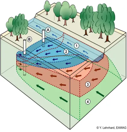
composition of this groundwater was found in many ways to be similar to that of river water (Fig. 4). At distances from a river of>300 m and at residence times of>20 d, fractions of young water from bank-filtration origin can hardly be distinguished from groundwater that originates from the seepage of precipitation. The shift in composi-tion is continuous from one groundwater type to the other, and thus the boundary of
5
300 m used in Table 1 is arbitrary. Groundwater of precipitation origin is mostly older than groundwater of riverbank. In this hydrogeological situation, alluvial groundwater is often stratified from the top, with layers of young and older groundwater of bank-filtration origin, and old groundwater of precipitation origin. This phenomenon qualifies the information of Figs. 2 and 3, which averages the concentrations over the depth.
10
4 Temporal changes of groundwater quality: example of the “Gugel I” Well
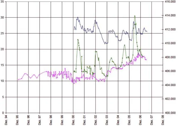
The well with the highest yield in the alluvial aquifer of the River Thur flood plain is the “Gugel I” Well (cantonal concession for 30 000 L min−1; “ Gugel I” in Fig. 1). In Fig. 5, a time series of nitrate and chloride concentrations of the period 2001 (nitrate), 1996 (chloride) – 2008 in this well is compared with the time series of the water table
15
elevation in a nearby monitoring well (“M ¨arstetten”, Fig. 1). Before 2003, baseline concentrations were monitored for both nitrate (with short-term peaks in summer 2001 and winter 2002/2003) and chloride (without peaks). Figure 5 shows that since then, the nitrate peak concentrations are superimposed to the base line and follow the higher water tables in summer. The general rise of the water table after a period of deep
20
groundwater levels, which followed the long decline in the hot and dry summer of 2003, coincides with the increase of the base line concentration of the two water quality parameters until the end of 2006. The concentrations correlate with a gradual increase of the water table. Since the beginning of 2007, the concentrations decrease. River Thur has lower nitrate concentrations than the groundwater (about 10 mg L−1). We 25
HESSD
7, 9023–9042, 2010Exchange between a river and groundwater
E. Hoehn and A. Scholtis
Title Page
Abstract Introduction
Conclusions References
Tables Figures
◭ ◮
◭ ◮
Back Close
Full Screen / Esc
Printer-friendly Version Interactive Discussion
Discussion
P
a
per
|
Dis
cussion
P
a
per
|
Discussion
P
a
per
|
Discussio
n
P
a
per
|
seepage of precipitation, rather than to bank filtration from River Thur. The nitrate peaks are delayed with respect to the maximum of the seasonally high water-table, by up to 50 d. We conclude from this that the peak impact of the nitrogen load originates from areas near the well.
The increase in nitrate concentrations is explained as follows: at falling water tables,
5
nitrate is stored in a continuously growing unsaturated zone of the aquifer. At subse-quently rising water tables, the nitrogen, which was stored in the unsaturated zone, is washed out and leads to concentration peaks in the groundwater. Hence the nitrate peak of 2004 can be attributed to a late effect of the low water table during the hot and dry summer 2003. In June 2006, the water table returned to the level of Spring 2003.
10
Nitrogen that was stored in the unsaturated zone during the four years’ period was subsequently washed out by the flowing groundwater. The increase in nitrate concen-trations due to leaching of nitrogen at a rising water table is responsible for about 1/3 of the total nitrate load in the groundwater of the Gugel I Well. The good correlation of the nitrate concentrations with the water table allows quantifying a concentration rise of
15
6 mg L−1per meter rise of the water table. This value can be used for future predictions. The chloride concentrations in the groundwater are about the same as those of River Thur. Different from nitrate, chloride did not exhibit peak concentrations that could be correlated with the rise of the water table.
5 Implications for river restoration
20
The results of the hydrochemical investigation exhibit an intensive interaction between the alluvial groundwater and River Thur. Many alpine and perialpine rivers exhibit simi-lar patterns of up- and downwelling like River Thur, and are accompanied by high-yield drinking-water wells. These wells have contributing areas that point in the direction of the river. River enlargements have the potential to alter the hydraulic conductivity of the
25
HESSD
7, 9023–9042, 2010Exchange between a river and groundwater
E. Hoehn and A. Scholtis
Title Page
Abstract Introduction
Conclusions References
Tables Figures
◭ ◮
◭ ◮
Back Close
Full Screen / Esc
Printer-friendly Version Interactive Discussion
Discussion
P
a
per
|
Dis
cussion
P
a
per
|
Discussion
P
a
per
|
Discussio
n
P
a
per
|
These processes can lead to spatial and temporal changes in the composition of the young groundwater of bank-filtration origin, due to a reduction of groundwater resi-dence times, combined with an increase of the fraction young hyporheic groundwater. These processes are accentuated, when downwelling occurs under saturated flow con-ditions. We conclude from our study that depending on the quality of the river water,
5
drinking-water wells near rivers can suffer from groundwater contamination following river restoration operations. The Swiss Ordonnance on Water Protection forbids river-bed enlargements in groundwater protection zones S2 of drinking-water wells. Our investigations give valuable information for water districts, to react with appropriate measures. They help to secure a sustainable groundwater quality during and after
10
restoration operations. Such measures could include, e.g., more intense quality con-trol of the well water, temporary closure of the well, admixture of water from a different source, or water treatment.
Acknowledgements. We thank Donald Kaden, kadenpartner ag, Frauenfeld, Switzerland, for the design and the implementation of the CHEMMAP computer model. We acknowledge with 15
thanks the redrawing of Fig. 1 from Fig. 2 of Vogt et al. (2009) and an internal review of the manuscript, by Tobias Vogt.
References
Cantonal Office for the Environment Thurgau: CHEMMAP, Projektbeschreibung f ¨ur ein
Pro-gramm zur Umwandlung von Punkt-Messdaten in Fl ¨achenkarten – Interner Bericht, Amt f ¨ur 20
Umwelt Kanton Thurgau, unpublished, project description for a computer program to
trans-form point data to maps, Internal Report, Cantonal Office for the Environment Thurgau,
unpublished, 2002.
Cirpka, O. A., Fienen, M. N., Hofer, M., Hoehn, E., Tessarini, A., Kipfer, R., and Kitanidis, P. K.: Analyzing bank filtration by deconvoluting time series of electric conductivity, Groundwater, 25
HESSD
7, 9023–9042, 2010Exchange between a river and groundwater
E. Hoehn and A. Scholtis
Title Page
Abstract Introduction
Conclusions References
Tables Figures
◭ ◮
◭ ◮
Back Close
Full Screen / Esc
Printer-friendly Version Interactive Discussion
Discussion
P
a
per
|
Dis
cussion
P
a
per
|
Discussion
P
a
per
|
Discussio
n
P
a
per
|
Diem, S., Vogt, T. and Hoehn, E.: R ¨aumliche Charakterisierung der hydraulischen Leitf ¨ahigkeit in alluvialen Schotter-Grundwasserleitern: ein Methodenvergleich, Grundwasser, in press, 15(4), doi:10.1007/s00767-010-0153-6, 2010.
FOPH: Swiss Handbook of Foodstuff, Schweiz, Lebensmittelbuch, SLB, Federal Office for
Pub-lic Health, BAG, Bundesamt f ¨ur Gesundheit, chap. 27A, Drinking Water, http://www.slmb.bag. 5
admin.ch/slmb/index.html, last access: November 2010, 2003.
Hoehn, E. and Meylan, B.: Maßnahmen zum Schutz flussnaher Trinkwasserfassungen bei
wasserbaulichen Eingriffen in Fliessgew ¨asser voralpiner Schotterebenen, Measures to
pro-tect drinking-water wells near rivers of perialpine flood plains, Grundwasser, 14(4), 255–263, doi:10.1007/s00767-009-0111-3, 2009.
10
Hoehn, E., Cirpka, O. A., Hofer, M., Zobrist, J., Kipfer, R., Baumann, M., Scholtis, A., and Favero, R.: Untersuchungsmethoden der Flussinfiltration, Investigation methods for river bank filtration, Gas-Wasser-Abwasser, 87(7), 497–505, 2007.
IPCC: Climate Change 2001: The scientific basis. Contribution of working group I to the 3rd as-sessment report of the Intergovernmental Panel on Climate Change, Cambridge Univ. Press, 15
Cambridge, 2001.
J ¨ackli, H.: Klassifikation von Grundwasservorkommen, Groundwater classification, Eclogae geol. Helv., 63(2), 389–434, 1970.
Lautz, L. K. and Fanelli, R. M.: Seasonal biogeochemical hotspots in the streambed around restoration structures, Biogeochemistry, 91(1), 85–104, 2008.
20
Matthess, G.: Beschaffenheit des Grundwassers – Lehrbuch der Hydrogeologie Band 2,
The Properties of Groundwater, German original version of Matthess, G., 1982, John Wi-ley & Sons, New York, Bebr ¨uder Borntr ¨ager, Berlin-Stuttgart, 2. Auflage, 498 pp., 1990. McKnight, D. and Bencala, K. E.: Reactive iron transport in an acidic mountain stream in
Summit County, Colorado, A hydrologic perspective, Geochim. Cosmochim. Acta, 53, 2225– 25
2234, 1989.
Peter, A.: A plea for the restoration of Alpine rivers: Basic principles derived from the “Rhone-Thur” Case Study, in: Alpine Waters, edited by: Bundi, U., Hdb. Env. Chem., Springer, Berlin, Heidelberg,6, 247–260, doi:10.1007/978-3-540-88275-6 5, 2010.
Scholtis, A. and Hoehn, E.: Beschaffenheit des Grundwassers im Thurtal, in: Ein neues
Grund-30
HESSD
7, 9023–9042, 2010Exchange between a river and groundwater
E. Hoehn and A. Scholtis
Title Page
Abstract Introduction
Conclusions References
Tables Figures
◭ ◮
◭ ◮
Back Close
Full Screen / Esc
Printer-friendly Version Interactive Discussion
Discussion
P
a
per
|
Dis
cussion
P
a
per
|
Discussion
P
a
per
|
Discussio
n
P
a
per
|
Vogt, T., Hoehn, E., Schneider, Ph. and Cirpka, O. A.: Untersuchung der Flusswasserinfil-tration in voralpinen Schottern mittels Zeitreihenanalyse, Riverbank filFlusswasserinfil-tration investigation in perialpine alluvial aquifer using time series analyses, Grundwasser, 14(3), 179–194, doi:org/10.1007/s00767-009-0108-y, 2009.
Woolsey, S., Capelli, F., Gonser, T., Hoehn, E., Hostmann, M., Junker, B., Paetzold, A., Roulier, 5
Ch., Schweizer, St., Tiegs, S. D., Tockner, K., Weber, Ch. and Peter, A.: A strategy to assess river restoration success, Freshwater Biol., 52, 752–769, 2007.
Zobrist, J.: Water chemistry of Swiss Alpine rivers, in: Alpine Waters, edited by: Bundi, U., Hdb. Env. Chem., Springer, Berlin, Heidelberg, 6, 95–118, doi:10.1007/978-3-540-88275-6 5, 2010.
HESSD
7, 9023–9042, 2010Exchange between a river and groundwater
E. Hoehn and A. Scholtis
Title Page
Abstract Introduction
Conclusions References
Tables Figures
◭ ◮
◭ ◮
Back Close
Full Screen / Esc
Printer-friendly Version Interactive Discussion
Discussion
P
a
per
|
Dis
cussion
P
a
per
|
Discussion
P
a
per
|
Discussio
n
P
a
per
|
Table 1. Average concentrations of chemical water constituents in water of River Thur, in
alluvial groundwater of wells located at distances of>300 m and<300 m from the banks of River
Thur, and in groundwater from valley slopes, and numbers of respective sampling stations.
River groundwater,<300 m groundwater,>300 m groundwater from Thur distance to River Thur distance to River Thur valley slopes
Number of 26 30 50 17
sampling stations
units
water temperature ◦C 10.2 11.1 11.1 11.1
pH (field) pH 8.4 7.5 7.2 7.3
electric µS/cm 449 500 641 723
conductivity 25◦C
O2 mg L−
1
11.5 3.6 5.9 8.2
O2Sat. % 108 41 58 62
DOC mg L−1
3.2 1.5 1.0 0.8
Ca2+ mg L−1
69 77 101 112
Mg2+ mg L−1
12 14 18 28
Na+ mg L−1
10 10 9 5
K+ mg L−1
2.4 2.8 2.5 1.4
Cl− mg L−1 13 13 14 13
SO2−
4 mg L
−1 11 12 15 29
NO−
3 mg L
−1 10 11 18 24
alkalinity mmol L−1 4.1 4.7 5.9 6.9
total hardness mmol L−1 2.2 2.5 3.7 4.0
HESSD
7, 9023–9042, 2010Exchange between a river and groundwater
E. Hoehn and A. Scholtis
Title Page
Abstract Introduction
Conclusions References
Tables Figures
◭ ◮
◭ ◮
Back Close
Full Screen / Esc
Printer-friendly Version Interactive Discussion
Discussion
P
a
per
|
Dis
cussion
P
a
per
|
Discussion
P
a
per
|
Discussio
n
P
a
per
|
Fig. 1. Map view of groundwater in River Thur valley aquifer, Switzerland. Axes of Swiss Federal Coordinate system. Blue and grey areas, groundwater thickness (dark blue, 11–20 m,
light blue, 2–10 m, grey,<2 m). Pink areas, towns. Green quadrangle, restored river section.
Red quadrangles, wells quoted in text. Thick blue lines, River Thur (blue, losing reach, green, gaining reach). Thin blue lines, mean groundwater isopotential lines (m a.s.l.) (map reproduced
with permission of Cantonal Office of Geoinformatics Thurgau, 29 October 2008; modified from
HESSD
7, 9023–9042, 2010Exchange between a river and groundwater
E. Hoehn and A. Scholtis
Title Page
Abstract Introduction
Conclusions References
Tables Figures
◭ ◮
◭ ◮
Back Close
Full Screen / Esc
Printer-friendly Version Interactive Discussion
Discussion
P
a
per
|
Dis
cussion
P
a
per
|
Discussion
P
a
per
|
Discussio
n
P
a
per
|
!
Fig. 2. Plan view representation of alkalinity in the groundwater of River Thur
val-ley, using CHEMMAP. Yellow, orange, and red hues, high alkalinity (>350 mg L−1;
61 mg HCO−
3L
−1
=1 mmol L−1), light and dark blue hues, low alkalinity (<350 mg L−1;
1 mmol L−1
=61 mg L−1). Colored domain: Alluvial groundwater, thickness>2 m. North is up;
HESSD
7, 9023–9042, 2010Exchange between a river and groundwater
E. Hoehn and A. Scholtis
Title Page
Abstract Introduction
Conclusions References
Tables Figures
◭ ◮
◭ ◮
Back Close
Full Screen / Esc
Printer-friendly Version Interactive Discussion
Discussion
P
a
per
|
Dis
cussion
P
a
per
|
Discussion
P
a
per
|
Discussio
n
P
a
per
|
!
Fig. 3. Plan view representation of oxygen concentrations in the groundwater of River Thur
valley, using CHEMMAP. Yellow, orange, and red hues, low concentrations (<5 mg L−1), light
and dark blue hues, high concentrations (>5 mg L−1). Colored domain: Alluvial groundwater,
HESSD
7, 9023–9042, 2010Exchange between a river and groundwater
E. Hoehn and A. Scholtis
Title Page
Abstract Introduction
Conclusions References
Tables Figures
◭ ◮
◭ ◮
Back Close
Full Screen / Esc
Printer-friendly Version Interactive Discussion
Discussion
P
a
per
|
Dis
cussion
P
a
per
|
Discussion
P
a
per
|
Discussio
n
P
a
per
|
Fig. 4. Schematic block diagram showing relationship between a river, losing water through a saturated bed, and groundwater: (1) River (light blue), (2 and 3) Groundwater of
river-bank filtration origin (dark blue, <300 m flow distance from river, and <20 d residence time;
pink,>300 m flow distance from river, and>20 d residence time), (4) groundwater not of
HESSD
7, 9023–9042, 2010Exchange between a river and groundwater
E. Hoehn and A. Scholtis
Title Page
Abstract Introduction
Conclusions References
Tables Figures
◭ ◮
◭ ◮
Back Close
Full Screen / Esc
Printer-friendly Version Interactive Discussion
Discussion
P
a
per
|
Dis
cussion
P
a
per
|
Discussion
P
a
per
|
Discussio
n
P
a
per
|
!