CHARACTERIZATION OF THE BRAZILIAN CONTINENTAL SHELF ADJACENT TO
RIO GRANDE DO NORTE STATE, NE BRAZIL*
Helenice Vital1,2**, Moab Praxedes Gomes1, Werner Farkatt Tabosa1,2, Eugênio Pires Frazão1, Claude Luiz Aguilar Santos2,3 and José Saraiva Plácido Júnior1
1Universidade Federal do Rio Grande do Norte – Programa de Pós-Graduação em Geodinâmica e Geofísica
ANP-MME-PRH 22
(Campus, P.O.BOX. 1596, 59072-970 Natal, RN, Brasil)
2Conselho Nacional de Desenvolvimento Científico e Tecnológico – CNPq
Consultor do Departamento de Geologia
3Museu Câmara Cascudo
(Av. Hermes da Fonseca, 1398 59020-650 Natal, RN, Brasil)
**Corresponding author: [email protected]
A
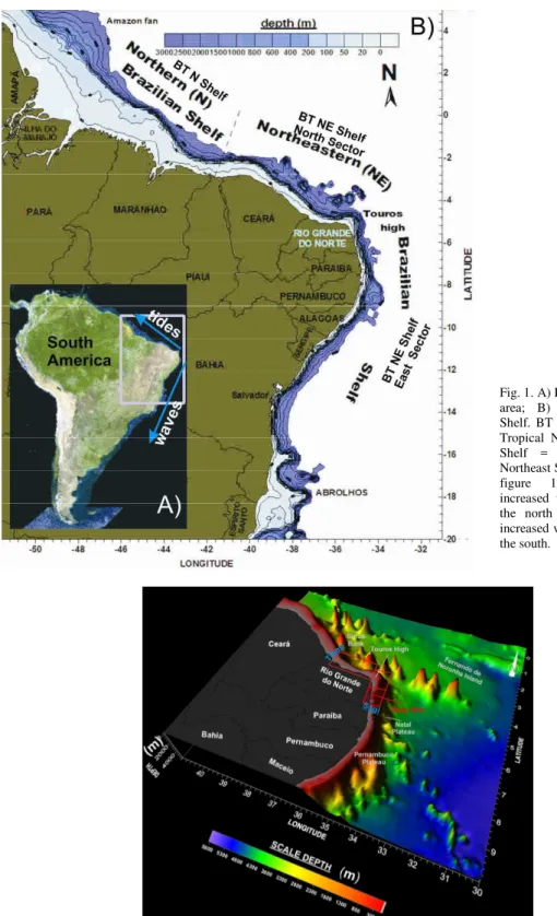
B S T R A C TThis study focuses on the analysis of high-resolution seismic profiles, integrated with sedimentological, echosounder, SRTM and satellite image datasets, of the Brazilian continental shelf adjacent to the Rio Grande do Norte State, NE Brazil. Located in the northeast of Brazil, the State of Rio Grande do Norte is bounded by two main coastal and shelf systems: the eastern coastal-shelf, from the Sagi River to the Touros High, and the northern coastal-shelf, extending from Touros High to Tibau. This shelf represents a modern, highly dynamic mixed carbonate-siliciclastic system characterized by reduced width and shallow depths as compared with other parts of the Brazilian shelf. It has an average width of 40 km, the shelf-break lying at a depth of ~ 60 m. This shelf is subject to the full strength of the westerly South Equatorial current combined with high winds and moderate to high tides and waves. A sharply defined stratigraphic boundary, probably between the Pleistocene and Holocene deposits, is clearly to be observed in the seismic record. Incised-valleys extending from the main river mouths (e.g.the Potengi, Açu, and Apodi) to the shelf break dominate the area investigated and may indicate periods of lower sea level.
R
E S U M OEste estudo está direcionado ao conhecimento da plataforma continental brasileira adjacente ao Estado do Rio Grande do Norte, NE do Brasil, através da analise de perfis sismicos de alta resolução integrados a dados sedimentológicos, batimétricos, SRTM e imagens de satélites. O Estado do Rio Grande do Norte, localizado no nordeste do Brasil, apresenta dois sistemas costeiros-plataformais: Setor Este, do Rio Sagi (divisa PB-RN) ao Alto de Touros e Setor Norte, do Alto de Touros a Tibau (divisa RN-CE). Esta plataforma representa um sistema plataformal moderno misto (carbonático-siliciclástico), altamente dinâmico. É caracterizado por sua reduzida largura e águas rasas, quando comparado com outras partes da plataforma brasileira. A plataforma apresenta largura média de 40 km e a sua quebra encontra-se a profundidades médias de 60 m. A plataforma é sujeita a ação da corrente sul equatorial, combinada a ventos fortes e variação de maré moderada a alta e/ou ondas. Um limite estratigráfico fortemente definido, provavelmente entre os depósitos Pleistocênicos e Holocênicos, pode ser bem observado e vales incisos, estendendo-se a partir dos principais rios (como por ex., Potengi, Açu e Apodi) dominam a área investigada.
Descriptors: NE Brazilian shelf, High resolution seismic profiles, Bedforms, Incised valleys, Beachrocks.
Descritores: Plataforma brasileira NE, Sísmica de alta resolução, Formas de fundo, Vales incisos, Beachrocks.
__________
I
NTRODUCTIONResearch on the Brazilian tropical shelf had its roots in the 1960s and 1970s (e.g. ZEMBRUSCKI, 1967; COUTINHO; MORAES, 1968; MABESOONE; COUTINHO, 1970; MILLIMAN et al., 1975; SUMMERHAYES et al., 1975). Brazilian Federal agencies, companies and universities have supported the REMAC Project (Global Reconnaissance of the Brazilian Continental Margin) and GEOMAR (Marine Geology surveys) cruises, which included the geological and geophysical examination of the Brazilian tropical shelf (e.g. AMARAL, 1979; KOWSMANN; COSTA, 1979; ASMUS, 1981). In the same line of research, new seismic and sedimentological data were incorporated by the LEPLAC project (Brazilian Continental Shelf Survey) from 1987 to 1996 and most recently, the REMPLAC (Mineral Reconnaissance of the Brazilian Continental Margin) initiative which began in 1997. Bilateral cooperation, such as the Brazilian/German Joint Oceanographic Projects (JOPS) that were begun in the 1990s, have also contributed to knowledge of the tropical Brazilian shelf (e.g. ARAUJO, 1994; KNOPPERS et al., 1999). The recognition of the complexity of oceanographic processes in coastal environments near large rivers and of the interrelationship of the processes involved, led to the interdisciplinary approach of AmasSeds (A Multidisciplinary Amazon Shelf Sediment Study) from 1980 to 1996, which was coordinated by academic institutions in the USA and Brazil. The results of these studies have been published for specific fields of oceanography (e.g. BEARDSLEY et al., 1995; GEYER; KINEKY, 1995; NITTROUER et al., 1996; NITTROUER ; DEMASTER, 1996) thus making the northern Brazilian shelf one of the most studied maritime areas in Brazil.
On the other hand, much of the Brazilian tropical margin, including a great portion of the northeastern tropical shelf, where the rivers are short and do not contribute significant amounts of sediment, has not yet been surveyed. This area is characterized by extreme oligotrophic boundary currents and the sedimentation of biogenic carbonates which dominate large areas of the shelf.
A lack of data is specially to be observed regarding the shelf adjacent to Rio Grande do Norte State, most probably because of the large number of reefs which prevent navigation.
Most of the recent investigations of the shelf adjacent to the State of Rio Grande do Norte have therefore been limited to selected areas, based on satellite images (VIANNA et al., 1991; TABOSA et al., 2007) and surficial sea bed sediment sampling (TESTA; BOSENCE, 1998; VITAL et al., 2005) or to specific investigations of reefs (e.g. SANTOS et al.,
2007) or shelf morphology (GOMES et al., 2007; GOMES; VITAL, in press). The existing literature contains but little information on shelf processes (e.g. TESTA; BOSENCE, 1999; LIMA; VITAL, 2006; TABOSA 2006) or high resolution seismic-stratigraphy (SCHWARZER et al., 2006; VITAL et al., 2008).
The aim of this paper, with a view to filling this gap, is to outline an integrated short review of the Rio Grande do Norte (RN), highlighting the development over the last 15 years of the interpretation of depositional environments in the shallow marine stratigraphic record.
Regional Setting
The Brazilian tropical northeast shelf is located in the eastern part of the northeastern region of the South American Platform and is referred to as the Borborema Province (ALMEIDA et al., 1981). Almeida et al. (1977) defined this Borborema Province as a “complex mosaic-like folded region” where important tectonic, thermal, and magmatic events took place during the Neoproterozoic interval assigned to the Brasiliano Cycle. The area covered by this province exceeds ~450 000 km2 and consists of
successive Cenozoic pediplains that developed at progressively higher elevations from the coastal regions inland, reaching elevations of 1100 m.
The Brazilian tropical shelf is classified as a passive or Atlantic type and varies considerably in shape and width, while it is rather wider near the Amazon mouth, it narrows near Salvador (Fig. 1). Sedimentation on this shelf ranges from a dominantly siliciclastic environment in the north, to carbonate sediments in the northeast.
The Brazilian tropical northeast shelf is characterized by the almost total absence of coral reefs and a complete lack of ooids or other precipitated carbonate, as previously recognized by Summerhayes et al. (1975). The shelf averages 40 km in width, and its break is commonly at an average depth of 60 m. The shelf slope has a gradient of up to 1:11, reaching a maximum of 28o at the Abrolhos Bank.
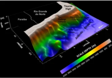
Fig. 2. Digital model of the Rio Grande do Norte Shelf. Red squares indicate the study area location.
The climate varies from tropical dry and semi-arid on the northern coast to tropical and humid on the eastern coast. From a morphodynamic point of view, the eastern sector is a wave-dominated coast with active sea cliffs carved into tablelands alternating with reef- or dune-barrier sections and beach-ridge terraces, while the northern sector is a mixed-energy complex of wave- and tide-dominated coast (VITAL, 2009). Dunes, ebb tidal deltas, beachrock, barrier islands and spits characterize the northern sector. This open-ocean facing shelf experiences high-energy, shoreline and shelf-margin parallel currents driven by a combination of oceanic, trade wind, tidal and wave processes. The processes operating on this shelf also play an important role in controlling the shelf morphology and sediment distribution (TESTA; BOSENCE 1999; VITAL et al., 2008).
M
ETHODSThe integrated data set used in this study includes remote-sensing, SRTM, oceanographic, hydroacustic and sedimentological data corroborated by diving surveys. Digital image processing techniques were used to gain an overview of the area and to plan further hydroacoustic and sedimentological acquisitions. The satellite images used in this research project were obtained from LANDSAT 7 ETM+ and were georeferenced under the UTM coordinates system with further processing by RGB 123 color composition including contrast enhancement and directional filters.
The hydroacoustic data were collected perpendicularly and parallel to the coast using a
HYDROTRAC echosounder, operating on a frequency of 200 kHz, a sub-bottom profiler (shallow seismic) type chirp, a X-Star 3200-XS (bandwidth 0.5 – 6 Hz) or boomer, and a side-scan sonar type 4100 272-TD type. Post-collection data processing consisted of the filtering and production of a digital terrain model with kriging as the geostatistical interpolation method (for bathymetry) and contrast enhancement, filtering and application of time variable gain (for seismic and sonography).
Hydrodynamic data were collected using different current meters (e.g. InterOcean and Anderaa), installed at 15 m water depth, that measured water current intensity and direction (FRAZÃO; VITAL, 2006; LIMA ; VITAL, 2006; TABOSA, 2006; HAZIN et al., 2008).
R
ESULTS ANDD
ISCUSSIONPhysiography
The Rio Grande do Norte shelf is very narrow and of a low gradient, averaging 0.2 and 0.5 in the northern and eastern sectors, respectively, and presenting an average width of 40 km along most of its length. Most of the eastern sector is 14-30 km wide, reaching its narrowest point adjacent to Natal and widening particularly in the Touros High area, where it extends to ~ 75-90 km. The continental shelf edge runs parallel to sub-parallel to the coast with a very sharp shelf break that starts at a depth of about 70 - 80 m around the Touros High and decreases westwards to 40-50 m depth (northern sector), and southwards to 50-60 m (eastern sector) (Fig. 3).
The inner-, middle-, and outer-shelf are commonly distinguished by their water depth as follows: inner shelf down to 15 m water depth, middle shelf between 15 and 25 m depth, and outer shelf from 25 m depth to the shelf break.
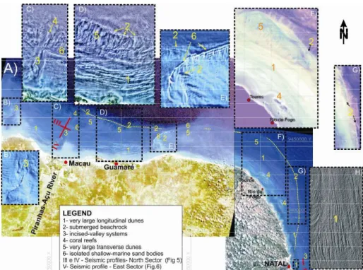
A variety of bedforms ranging from tens of centimeters to kilometers in scale are present in the shallower parts of the shelf, indicating reworking processes. They are clearly observed by Landsat image or hydroacoustic devices (e.g. VIANNA et al., 1991; TABOSA, 2006; VITAL et al., 2005, 2008; GOMES et al., 2007). Some of these seabed features are observed in both the northern and eastern sectors and may be summarized as follows:
1) Very large longitudinal dunes on the inner shelf (≤ 6 m high, 400 m to ≤ 900 m wide and kilometer scale in extension);
2) Small wave- and current-generated dunes generally superimposed on the very large dunes described above;
3) Submerged beachrock chains occurring parallel to the coast at different depths (10, 20-25, 40 and 60 m). Their elevations reach 2.5 to 5 m above the sea-floor, and their widths vary between 500 and 1000 m (TABOSA; VITAL, 2006; GOMES et al., 2007; SANTOS et al., 2007; VITAL et al., 2007, 2008); 4) Incised-valley systems;
5) Coral reefs.
Other seabed features are restricted solely to the northern sector, and consist of:
6) Very large transverse dunes with crests oriented in a northeasterly-southwesterly direction (obliquely or transversal to the coast);
7) Isolated shallow-marine sand bodies (over 50 km in length).
Besides the features described above, the most important traces of the continental terraces are the Natal plateau and the marginal Rio Grande do Norte plateau (Fig. 3).
Oceanographic Processes
The Brazilian northeastern tropical shelf is located within the trade wind belt and experiences high-energy, coastal and shelf parallel currents driven by combined flows due to oceanic, tidal and wave processes. The trade winds arise in the E-SE (sensu stricto trades) in the eastern sector and in the NE
(return trades) in the northern sector. Since strong winds prevail almost the whole year round, the water masses are well mixed without any characteristic stratification (VITAL et al., 2008). The wave pattern is determined by variations in the trade winds, i.e. those related to offshore high-pressure center variations. This tropical shelf is mainly dominated by relatively high sea waves, those with heights above 100 cm accounting for more than 50% of them (MESERVE, 1974). Waves measured during the summer period in the northern sector have, however, an average height of 56 cm with maximum heights of ~120 cm and minimum heights of 27 cm (VITAL et al., 2008; VITAL, 2009). Waves measured during the summer period on the shelf near Natal in the eastern sector, have an average height of ~90 cm with similar 120 cm maximum heights, and minimum heights of 50 cm (VITAL ET AL., 2008; VITAL, 2009).
The North Brazil Current flows relatively parallel to the coast over the narrow shelf. Current velocities reach 30-40 cm/s, overlain by tidal and wave components (KNOPPERS et al., 1999). Longshore currents on this shelf flow mainly northwards and westwards with maximum velocities of 105 and 97 cm/s in the eastern and northern sectors, respectively. Current velocities decrease to a maximum of 25 cm/s and average 6 cm/s close to the Touros High (HAZIN et al., 2008). Tidal currents, however, change their direction of flow according to tidal variation and are by far the dominant contributor of sediments to the shelf system.
The Brazilian tropical northeast shelf has a mesotidal, semi-diurnal regime with maximum heights of 2.7 m and 2.0 m for spring- and neap-tide, respectively, in the eastern sector. Tidal measurements show that average ranges of spring- and neap-tides are 2.2 m and 1.3 m, respectively (VITAL et al., 2008). The relative tidal range (RTR), mean spring tidal range (MSR) and wave height (Hb) for this sector is 3 < RTR < 9 (Vital 2009). Sea-level changes measured in the northern sector show maximum tidal heights of 3.3 m and 2.5 m, respectively, during spring- and neap-tides. The RTR for this sector is 4 < RTR < 15
and so is to be classified in the mixed wave-tide group (VITAL, 2009).
Sedimentology
The inner shelf, in both sectors, is characterized by a belt of siliciclastic quartz-rich sands, however this siliciclastic sand belt is wider in the northern sector, and a complex of mixed carbonate-siliciclastic medium grained sands is found between 10-15 and 25 m water depths. Carbonates, however, dominate the Touros High where the siliciclastic sedimentary cover is almost absent. High-frequency relative sea-level changes have resulted in a complex association of Quaternary highstand carbonates and lowstand siliciclastic facies, which are currently being blended on the middle shelf. While siliciclastics originate from river discharges, coastal erosion and reworked relict deposits of former lower sea-level stands, the carbonates have their source in the locally-produced grains by the growth and transport of calcareous organisms (TESTA; BOSENCE, 1999; VITAL et al., 2008). Much of these carbonate enriched sands are sedimentary relict and contain a completely reworked biogenic fraction, except on the inner part of the shelf where they are constantly removed by waves and currents. Modern biogenic components are also observed. Quartz is the main component of the siliciclastic sediments (85 – 100%), although feldspar is also present in most samples (5 - 15%). The mineralogical fraction includes mica, glauconite and heavy minerals (VITAL et al., 2008).
Bioclastic carbonate gravel and very coarse sands related to the growth of branching coralline algae dominate the outer shelf. In situ development of rhodoliths produces a consistently coarser sized fraction. Halimeda (a genus of green macroalgae) and different types of mollusks are also common but contribute variable amounts of granule- to sand-sized material to the sediments. Benthonic foraminifera, ostracods, gastropods and bivalves occur in smaller numbers (TESTA; BOSENCE, 1998, 1999; TABOSA 2006). Most of the carbonate assemblage shows some degree of reworking, and consists of mixtures of recent and reworked organisms.
Corals knolls and patch reefs are sparse in the northern sector but present in the eastern sector of the inner shelf, especially around the Touros High, where the largest coral reefs of RN grow (Fig. 4). Like other Brazilian reefs, the coral fauna has very low diversity and significant endemism (SANTOS et al., 2007).
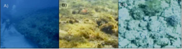
Submerged sand banks are common along this shelf. They are observed at different depths (of 10, 20, 40 and 60 m),the most continuous and prominent structure being found on the 20-25 m isobaths and extending from Natal (eastern sector) to Macau (northern sector) (Fig. 5A). Samples taken by diving, both in the northern and eastern sectors and on the Touros High, revealed laminated sandstone cemented by carbonates, similar to the beachrocks commonly exposed along the coast and could be related to ancient coastlines (Santos et al., 2007). Their sediments are often overlain by a thin corallinaceae algae (Fig. 5B) encrustation and large numbers of rhodolites (Fig. 5C) and sponges. Echinoderms, mollusks, bivalves, gastropods, polychaetes and cloroficeas algae are also widely found (VITAL et al., 2007, 2008).
Fig. 5. View of the seabed adjacent to Rio Grande do Norte State. A) Submerged beachrock at 25 m water depth; B) corallinaceae algae; C) rhodolites.
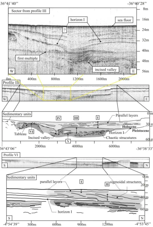
Stratigraphy
High resolution seismic data relating to the Brazilian tropical northeast shelf are scarce. Investigations of the subsurface geology and structures of the northern sector by Schwarzer et al (2006) focused on the interpretation of seismostratigraphic units and are used here to visualize the shelf´s subsurface.
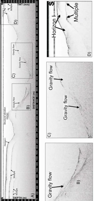
Schwarzer et al. (2006) identified 7 Units (Fig. 6) and concluded that the Brazilian Tropical northeastern shelf adjacent to Rio Grande do Norte State has undergone regressive and transgressive stages ever since the Pleistocene. The entire channel structure from the main river mouths to the shelf edge may thus be regarded as incised valley morphology, cutting into the shelf´s ancient deposits during sea level lowstands. The incised valleys are currently represented by cut and fill structures in the northern sector (Unit IV) indicative of the erosive force of the rivers under lowstand conditions (Fig. 6A, 6C). Unit IV contains many strong reflectors interpreted as pebble beds or consolidated sediments. Interestingly
the canyon filling structures are not observed in the eastern sector. It is, however, possible to identify a structural dome-shaped high in the most distal part of the Potengi River canyon, probably indicating the presence of a gravity flow mechanism of transport and sedimentation (Fig. 7).
The hummocky features observed in Unit V may suggest relic fluvial sedimentary structures originating from meandering rivers (SCHWARZER et al., 2006; VITAL; LIMA, 2006). Unit VII is interpreted as the surface and its underlying layers under lowstand conditions. These sediments are clearly distinct from those of Unit I, which top stand for the present seafloor. Unit I consists of Pleistocene to early Holocene parallel marine sediment layers intercalated with terrestrial deposits and resulting from sea level fluctuations.
A seismically transparent Unit III occurs immediately below horizon I, but overlies the hummocky structures (Unit V) and the incised valley deposits (Unit VI). Elsewhere, lagoonal deposits are characterized by their seismic transparency and poor internal stratification arising from their very high silt, clay and organic material content. The location of Unit III and its seismic facies characteristics are thus consistent with early Holocene deposition in a low energy environment sheltered by embankments or ridges.
Sigmoidal structures characterize Unit II, particularly at the transition between horizon I and the overlying sub-horizontal layers of Unit I (Figs 6E, 6F). This configuration of seismic reflectors is indicative of a sea level rise combined with low sediment supply, which permits topset beds to aggregate simultaneously with foreset progradation (Fig. 6E, 6F). In this case, such structures would develop during a sea level rise accompanied by a prograding shoreline, but the structures observed do not allow a proper distinction to be made between these scenarios if the sigmoidal structures are arranged within topset layering. The slight offshore increase in depth of Unit II may, however, indicate the absence of topset layering but may just as well stand either for an interval of a fall in sea level, stagnation or a periodic increase in sediment supply. Such a model accords well with the interpretation of Schwarzer et al. (2006) regarding Unit III.
C
ONCLUSIONSThe following conclusions may be drawn from this study:
• The Rio Grande do Norte tropical northeastern shelf comprises two different sectors, separated by the Touros structural High: 1) an eastern sector extending from the Sagi River to the Touros High and 2) a northern sector extending from the Touros High to Tibau City. The inner-, middle-, and outer-shelf are commonly distinguished by different water depths as follows: the inner-shelf down to 15 m, the middle shelf between 15 and 25 m, and the outer shelf from 25 m out to the shelf break.
• The northern sector shelf is wider and is characterized by greater amounts of siliciclastic sediments than is the eastern sector. Very large transversal and longitudinal dunes are both present in these sectors, as well as isolated shallow-marine sand bodies.
• High resolution seismic profiling permits the identification of 7 Units on the Brazilian tropical northeastern shelf indicating intercalation of regressive and transgressive stages since the Pleistocene.
• Channel structures originating at the mouths of the main rivers and extending to the shelf edge can be regarded as incised valleys which cut into the shelf deposits during sea level lowstands. The ancient rivers (e.g., Açu and Apodi) meandered within these incised valleys, cutting into the shelf deposits and forming the smaller incised valleys that are currently represented by cut and fill structures and are indicative of riverine erosive forcing under lowstand conditions.
• The narrowest shelf (14-30 km wide) occurs in the eastern sector, which is characterized by predominantly bioclastic sediments. No canyon filling, large transversal dunes or isolated shallow-marine sand bodies were observed in this sector.
• It was, however, possible to identify a structural high in the most distal part of the Potengi River canyon indicating the presence of a gravity flow mechanism of transport and sedimentation. • Corals knolls and patch reefs are sparse in the
northern sector but frequent on the inner shelf along the eastern sector, especially around the Touros High. The most important traces of continental terraces are the Natal plateau and marginal Rio Grande do Norte plateau.
• Submerged sand banks are common along this shelf. They are observed at different depths (of 10, 20, 40 and 60 m), the most continuous
occurring on the 20-25 m isobaths and extending from Natal (eastern sector) to Macau (northern sector). Previous petrographical studies had revealed laminated sandstone cemented by carbonates, similar to beachrocks commonly exposed along the coast and should be related to ancient coastlines.
A
CKNOWLEDGEMENTSWe wish to thank the PRH-ANP 22 (Brazilian National Oil Agency) and CAPES for the scholarships awarded, respectively, to M. P.Gomes and E. P. Frazão, and to J. S. Plácido Jr., as also the CNPq for the productive research grant (number 312275/2006-4) given to H. Vital and the R&D scholarship presented to W. F. Tabosa. Financial support for field and laboratory work was provided by the following projects: POTMAR-SISPLAT-PETRORISCO (REDE 05/FINEP/CTPETRO/ CNPq/ PETROBRAS) and MAR-RN (FINEP/CTINFRA). Thanks are also due to GGEMMA and the GEOPRO (DG/PPGG /UFRN) group, especially to the technicians Canindé and Junior for their assistance on the field, even under difficult weather conditions. The critical comments of an anonymous reviewer are gratefully acknowledged.
R
EFERENCESALMEIDA, F. F. M.; HASUY, Y.; BRITO NEVES, B. .B.; FUCK, R. A. Provincias Estruturais Brasileiras. SIMPÓSIO DE GEOLOGIA DO NORDESTE, 7., 1977, Campina Grande. SBG, p. 363-391, 1977.
ALMEIDA, F. F. M.; HASUY, Y.; BRITO NEVES, B. B.; FUCK, R. A. Brazilian structural provinces: an introduction. Earth Sc. Rev., v. 17, p. 1-29, 1981. AMARAL, C. A. B. (Ed.). Recursos minerais da margem
continental brasileira e das áreas oceânicas
adjacentes. Rio de Janeiro, PETROBRAS, 1979. 112 p. (Série Projeto REMAC, 10).
ARAUJO, T. C. M. Seismostratigraphic interpretation of the Amazon Continental Margin in view of sea level changes and subsidence of the sea floor. 1994. PhD Thesis, Christian Albrechts Universität, Kiel, Germany,1994.
ASMUS, H. E. (Ed .). Estruturas e tectonismo da margem continental brasileira, e suas implicações nos processos sedimentares e na avaliação do potencial de recursos minerais. Rio de Janeiro: PETROBRAS, 1981. 269 p. (Série Projeto REMAC 9).
CÓRDOBA, V. C.; JARDIM DE SÁ, E. F.; SOUSA, D. C.; ANTUNES, A. F. Bacia de Pernambuco-Paraíba. Bolm Geociênc. Petrobras, v. 15, n. 2, p. 391-403, 2007. COUTINHO, P. N.; MORAES, J. O. Distribution de los
sedimentos em la plataforma continental norte-nordeste do Brasil. SYMPOSIUM ON INVESTIGATIONS AND RESOURCES OF THE CARIBBEAN SEA AND ADJACENT REGIONS, 1968. UNESCO, p. 261-284, 1968
FRAZÃO, E. P.; VITAL, H. Evidences of sea level changes on the NE Brazil during the Neogene: The Potengi system (river and shelf) example. In: CAMOIN, G.; DROXLER, A.; FULTHORPE, C.; MILLER, K. (Ed.). Sea level changes: Records, processes, and modeling SEALAIX 06. Paris: Publi. ASF, v. 55, p. 54-55, 2006. (Abstract book).
GEYER, W. R.; KINEKE, G. C. Observations of currents and water properties in the Amazon frontal zone. J. Geophys. Res., v. 100, p. 2321-2339, 1995.
GOMES, M. P.; VITAL, H; MACEDO, J. W. P. Aplicação da geoestatística na filtragem de dados batimétricos e altimétricos na Bacia Potiguar. Rev. Geol., v. 20, n. 2, p. 243-255, 2007.
GOMES, M. P.; VITAL, H. Revisão da compartimentação geológica da plataforma continental norte do Rio Grande do Norte – Brasil. Rev. Bras. Geol. In press.
HAZIN, F. H.V.; WOR, C.; OLIVEIRA, J. E. L.; HAMILTON, S.; TRAVASSOS, P.; GEBER, F. Resultados obtidos por meio do fundeio de um correntógrafo na plataforma continental do Estado do Rio Grande do Norte, Brasil. Arq. Ciênc. Mar, v. 41, n. 1, p. 30-35, 2008.
KNOPPERS, B.; EKAU, W.; FIGUEIREDO, A. G. The coast and shelf of east and northeast Brazil and material transport. Geo-Mar. Lett., v. 19, p. 171-178, 1999. KOWSMANN, R. O.; COSTA, M. P. A. Sedimentação
Quaternária da margem continental Brasileira e das
áreas oceânicas adjacentes. Rio de Janeiro:
PETROBRAS, 1979. P. 1-55. (Série Projeto REMAC, v. 8.).
LIMA, S. F.; VITAL, H. Geomorphological and paleogeographic characterization of continental shelf of the Apodi-Mossoro River, RN-Brazil. In: BREBBIA, C. A. (Ed.). Environmental problems in coastal Regions VI including oil spill Studies. Wessex: Institute of Technology; Great Britain: Cambridge Printing, 2006. p. 351-360.
MABESOONE, J. M.; COUTINHO, P. N. Littoral and shallow marine geology of Northern and Northeastern Brazil. Trabhs Oceanogr., Univ. Fed. Pernambuco, v. 12, p. 1-214, 1970.
MARTINS, L. R.; COUTINHO, P. N. The Brazilian Continental Margin. Earth-Sci. Rev., v. 17, p. 87-107, 1981.
MESERVE, J. M. U.S. Navy marine climatic atlas of the world, North Atlantic Ocean. Washington, v. 1, 1974. p. 371.
MILLIMAN, J. D.; SUMMERHAYES, C. P.; BARRETTO, H. T. Quaternary sedimentation on the Amazon continental margin: a model. Geol. Soc. Am. Bull., v. 86, p. 610-614, 1975.
NITTROUER, C. A.; DeMASTER, D. J. The Amazon shelf setting: tropical, energetic and influenced by a large river. Continent. Shelf Res., v.16, p.553-573, 1996.
NITTROUER, C. A.; KUEHL, S. A.; FIGUEIREDO, A. G.; ALLISON, M. A.; SOMMERFIELD, C. K.; RINE, J. M.; FARIA, L. E. C.; SILVEIRA, O. M. The geological record preserved by Amazon shelf sedimentation. Continent. Shelf Res., v. 16, p. 817-841, 1996. PESSOA NETO, O.C.; SOARES, U.M.; SILVA, J.G.F.;
ROESNER, E.H.; FLORENCIO, C.P.; SOUZA, C.A.V. Bacia Potiguar. Bol. Geociênc. Petrobras, v. 15, n. 2, p. 357-369, 2007.
SANTOS, C. L. A.; VITAL, H.; AMARO, V. E.; KIKUCHY, R. K. P. Mapeamento de Recifes na plataforma continental. Nordeste do Brasil: Touros a Maracajau – RN. Brazilian J. Geophys.., v. 25, n. 1, p. 27-36, 2007.
SCHWARZER, K.; STATTEGGER, K.; VITAL, H.; BECKER, M. Holocene Coastal Evolution of the Rio Açu Area (Rio Grande do Norte, Brazil). J. coast Res., Special Issue 39, p. 140-144, 2006.
SUMMERHAYES, C. P.; COUTINHO, P. N.; FRANÇA, A. M. C.; ELLIS, J.P. Part III. Salvador to Fortaleza Northeastern Brazil. Part III. Contr. Sedimentol., Stuttgart, v. 4, p. 44-78, 1975.
TABOSA, W. F. Morfologia, hidrodinâmica e sedimentologia da plataforma continental brasileira adjacente a São Bento do Norte e Caiçara do Norte – RN; NE Brasil. 2006. PhD Thesis, Universidade Federal do Rio Grande do Norte, Natal.
TABOSA, W.F.; VITAL, H. Hydrodynamic forcings and environmental impacts on the coast and shelf of São Bento do Norte, NE/Brazil.; Environmental problems in coastal Regions VI. Including Oil and Chemical Spill Studies. UK: WIT Press, 2006. p. 165-174.
TABOSA, W. F.; AMARO, V. E.; VITAL, H. Caracterização do ambiente costeiro, integrado a produtos de sensoriamento remoto na região de São Bento do Norte/Caiçara do Norte—NE Brasil: Rev. Bras. Geofis., v. 25, Supl. 1, p. 37–48, 2007.
TESTA, V.; BOSENCE, D. W. J. Carbonate-Siliciclastic Sedimentation on High-Energy, Ocean-Facing, Tropical Ramp, NE Brazil. In: WRIGHT, V. P.; BURCHETTE, T. P. (Ed.). Carbonate Ramps. Geol. Soc. London Spec.Pub., v. 149, p. 55-71, 1998.
TESTA, V.; BOSENCE, D. W. J. Physical and Biological Controls on the Formation of Carbonate and Siliciclastic Bedforms on the North-East Brazilian Shelf. Sediment., v. 46, p. 279-301, 1999.
VIANNA, M. L.; SOLEWICZ, R.; CABRAL, A.; TESTA, V. Sandstream on the Northeast Brazilian Shelf. Continent. Shelf Res., v. 2, p. 509-524, 1991.
VITAL, H. The mesotidal barriers of Rio Grande do Norte. In: DILLEMBURG, S.; HESP, P. (Ed.). Geology of Brazilian Holocene Coastal Barriers. Heidelberg: Springer-Verlag, 2009. p.289-324.
VITAL, H.; SILVEIRA, I. M.; AMARO, V. E. Carta sedimentólogica da plataforma continental brasileira - área guamaré a macau (ne brasil), utilizando integração de dados geológicos e sensoriamento remoto. Rev. Bras. Geofis., v. 23, p. 233- 241, 2005.
VITAL, H.; STATTEGGER, K.; AMARO, V. E.; SCHWARZER, K.; FRAZÃO, E. P.; TABOSA, W. F. A. Modern high-energy siliciclastic-carbonate platform: Continental shelf adjacent to Northern Rio Grande do Norte State, NE Brazil. In: HAMPSON, G., STEEL, R., BURGUESS, P. DALRYMPLE, R. (Ed.). Recent
advances in models of siliciclastic shallow-marine
Stratigraphy. SEPM Special Issue, v. 90, 177-190,
2008.
ZEMBRUSCKI, S. J. Sedimentos da plataforma continental do Brasil. XXII Comissão Oceanográfica Noc. Almirante Saldanha. Rio de Janeiro: Dir. Hidrog. Naveg. DG 26-X, apendice B, 1967. p. 389-409.