(
Ciencias da Terra (UNL) Lisboa N"15 pp.239-248 2003 3 Figs.On the hydrogeology of the Lower Tagus Basin and its
Cen ozoic geologic evolution
Manue la
Simoes
Centro de Estudos Gcolcgi cos de UNL. Qui nta da Torre. 2829 -5 16 Caparica. Portugal.mmsr@fC t.unl.pl
Ab stract
Key-words: Hydro geology; Lower Tagus Basin; Cenozoic; geologi ca l evolution.
The chemica l features o f the grou nd water in the Lowe r Tagus Cenozoic de posits ar e strong ly influ encedbylithology,bythe velocity and d irection of the water mov eme nt as well asbythe localizat ion o f the recharge and d ischarge zones.
T he m inerali zation varies betwee n 80 and 900 rng/ l. It is minimal in the recharge zones and in the Pliocene sand. and max imum in the Miocen e carbona ted and along the alluvial valley. Minera lization always reflects th e time of permanence, the temperature and the pressure.
The natura l process of wate r mine ralization is disturbed in agricult ural areas because the saline concentration of th e infiltra tion water exceeds that of the in filtrated rai nwater.
In the discharge zones , the rise of the more mineralized, some times therma l deep waters related to tectonic accidents give rise to anom alies in the distribution of the aquiferous sys tem minerali zation mode l.
The diversity o f the hydrochemic a l facie s of't he grou nd water may be related to se vera l factors whose ident ification is some times diffic ult.
Resumo
Palavrus-ch ave : I lidrogeo logia; Bacia do Baixo Tejo; Ceno zoico; evol ucao geo logica .
A composicao das agua s subtc rraneas que circu lam atraves dos depos itos cenozoicos da Bacia do Baixo Tejo
e
forternente infl uenciad a pela Iitologia das camadas aquife ras, pelo regime de fluxos e pela localizacao das zonas de recarga e descarga . A mi nerali zacao varia entre 80 e 900 mg/l, sendo m inima nas zonas de recarga e nos depos itos arenosos pliocenicos e maxima nos depositos carbonatados do Miocen ico e ao lange do vale, reflec tindo, em cada caso, a perman encia no aq uifere, a temperatura e a pressao.Em zonas ag ricolas,0processo natural de rnineralizacao das agua s so fre pcrturbacocs, uma vez que a concentracao de sa is nas ag uas de infiltracao excede a mincrali zacao da precipitacao,
Nos locais de descarga, a subida de aguas pro fundas rnais mineralizadas, as veze s termais, rclacionadas com ac identes tecton icos de ambit o regional ge ra anornalia s no modelo de dis tribuicao da min eralizacao pela s istema aq uifere.
A diversidade de facies hidroq u im icas das ag uas subterraneas pode relacionar-se com var ies factores , as vezes dificeis de ide ntificar.
Introduction
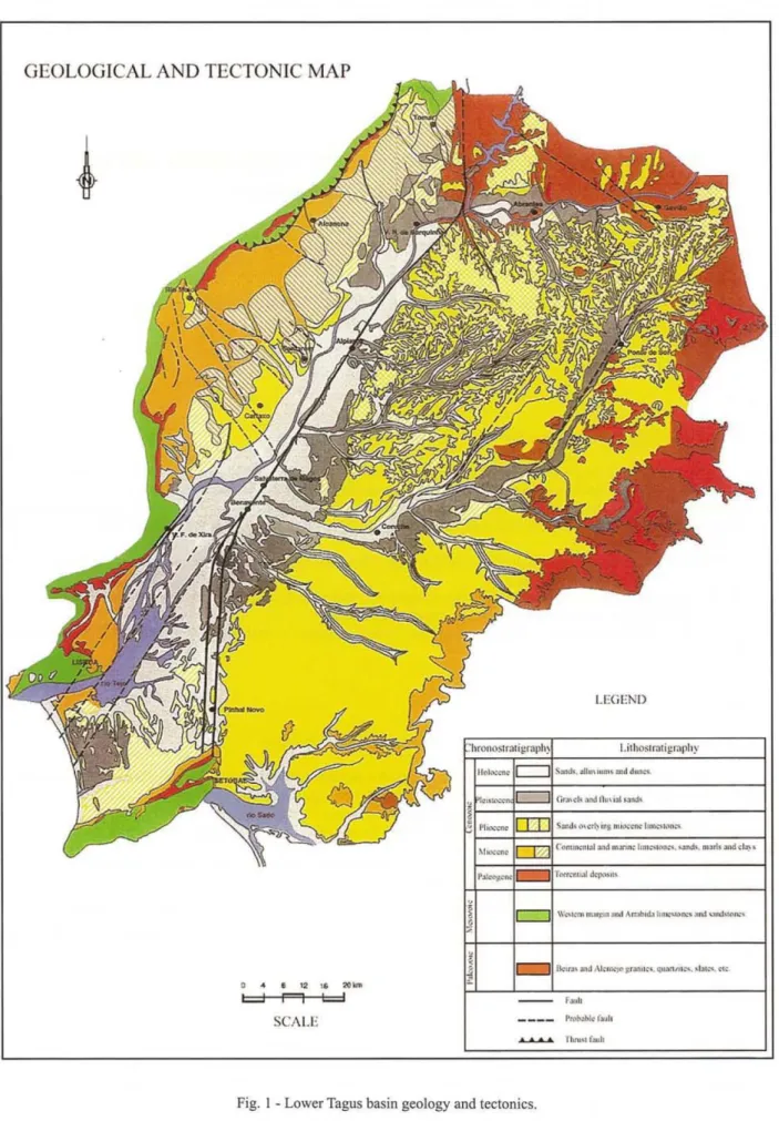
This study conce rns the Hydrogeology of the Cenozoic depo sits along the Tagus valley between Constancia and Se niba l, set by the parallels 6° 30 ' 00" and 9° 40' 00" W, and by meridians 37°0 0' 00" and 40° 46' 00" N (European datum). The concern ed area is bound by the Mesozoic at
Northwest and North, by the "Macico Antigo" at Nor th and No rtheast; in the So u th by the A lva lade Basin (Antunes, 1986); and in the West by the Atlantic Ocea n (Fig . I) .
Ciencias ciaTerra( UN L). 15
GEOLOG ICAL AND TE CTON IC MA P
I.E<iEN()
h "h
SCAI.E I'n>Ntold,..ll
... TIuu..r...h
seven hundred and fifty five samples of ground waters from wells and springs, as water from the river Tagus were recognized
Geolog ic settings
The Lower Tagus Basin had a tectonic origin in the Eocene after the NE-SW reactivation the hereinic faults. Tectonics, eustatic variations, lithology ofthe peripheric relief and climate have conditioned the sedimentation. The Basin is filled with materials from the "Macico Calcario" and from the "Macico Antigo".
Pa leogene
The Paleogene units are formed by reddish, imma-ture sediments: polygenic conglomerates, sandstones, clayey sandstones, claystones, limestones and marls.
Inth e Li sbo n region , th er e are 425 m thi ck co ntinental deposits reported to the Paleogene, thc "B enfica Complex". These deposits overlie the upper Cretaceous, Lisbon-Mafra Volcanic Formation and are overlain by the mostly marine Miocene infillings of the lower Tagus basin.
The lower subunits of the "Benfica Complex" are esp ecia lly rich in detrital material s co ntrib ute d by Paleozoic uni ts, including those from granites that originated qu ite deve lopped arkose laye rs. Quartz, quatzite, schist and other clasts are common. Later on, jurassic limestones, sandstones, silex and even basalt clasts pr eva il. Caliche le vel s are known , as the "A lfornelos Limestone". The upper part of the "Benfica Complex" may be Oligocene in age.
On the right bank of the Tagus, there are northward outcrops of the "Benfica Complex", upwa rds north , leaned to the Mesozoic in discontinued lanes. Thickness attains up to 100 m (A lofo rmacao de Monsanto, Barbosa, 1995). This units comprises "Cheganeas and Casais Complex" (including the Quinta da Marquesa limestones), the "Ab rigada Complex", the "Alcanede Complex" (Mo nsa nto sa ndstone and A lcanede limestones) and the "Cabos Complex" . Sands, clays, arkoses and marls with limestones concretions outcrop at Gaviao, Montargil , Ponte de Sor and Mora. The thickness in the oriental part of the Basin is about 50 m (Barbosa, 1995).
In th e Setubal region ther e are co mposed by Paleogene reddish sandstones, conglomerates, red marls and white limestones with lacustrine fauna near the top.
Itcontains twinned gypsum crystals (Cholfat, 1908). The maximum thickness (200 m to 300 m) is attained west of the Ribeira de Coina (Choffat,op. cit.).
At the north ern boundary of the Basin, near the Iberia n Ce ntral Ridge, sandstones whith carbonate caliches and few Iydite clasts can be see n on the Paleozoic. Thickness does not exceed 12 m. At Maceira, white quartz clasts predominate over (90%), granite and Iydite ones (Barbosa, 1995).
Ciincias da Terra (UNLJ. 15
Sedime nts (mos tly sands) , were depo sited through gravitational flow under a select ive and badly defin ed water regime.
The main drainage, more or less NE-SW paleogene direc tions (p ro bab ly three) fo llow hercinic tectonic accidents (Tagus, Ponte de Sor, Gaviao, Nazare fault, the Zezere river). They were joined by transversal streams. The main drainage directions can be identifiedwith former rivers related to extant ones: the Tagus downstream of Constancia, the Sorraia and Erra rivers.
A preceding river of the Zezere had its mouth near Nazare.Itdrained the southern part of the Iberian Central Ridge, at least during the Eocene. The same river was later captured by the Tagus. The submarine canyon of Nazare, the most important one of the western Europe, must have been a discharge channel of this river.
The evo lutio n of this regio n was a complex on e because of its location at the end of the Iberian Central Ridge. As a consequence, two main drainages became possible: through Zezere in thc southern part and, in the opposi te part, th e Douro ri ver, whose nor th ward s migration has occurred (Antunes, 1979; p.163). With this hypothetical river (the drainage regime at the time was torrent like) must be related the Eocene deposits between Nazare and S. Pedro de Muel, called "Fe ligueira Grande Complex" (Zbyszewski, 1965).
The forerunners of the A lmonda and Nabao rivers drained granites, schists, quartzites and graywackes from Beiras as well as the "Macico Calcario Estremenho". A pre-Tagus river went along since Gaviao, Bemposta and Erra until Senibal, by through the eastern side of the Serra de Sao Luis. The Sorraia drained the "Macico Antigo" to the east, and developped its course southwards; more or less ended at the Aguas de Moura channel.
The hydrographic basins and the drainage network of these "rivers" (it might be j ust be primary directions) where probably poorly ill defined in the Paleogene.These "rivers" allowed connections amongst them, defining a big reception basin, probably due to intensive and long rain events. The deepest and with the largest flow river would be the one along the Tagus valley and maybe the Zezere valley.
The drainage was ensured by torrents during the rain season, from the "Macieo Calcario Estremenho" and the "Macico Antigo" to the reception basin. The discharge was through a channel or dejection cone towards the Atlantic Setubal and Nazare canyons.
The erosive action is regressive , that is, the erosion at the upstream part of the course constantly makes its origin to step back. Other water lines could have been captured .
M iocene
Cienci as da Terra (UNLj, 15
on by the ri vers o r res ults from bio log ica l ac tio n, Componen ts were carried from the co nti nent into thc sea, E uststatic variation is ou tsta nding and really determ inan t in the Mioce ne. These were responsible for the regressions and transgressions (Antunes, 1971), during Miocene and Pliocene times.
The Miocene series thickness differences betweeen thc ocean-open part and the center of the Bas in may resul t from factors acting simultaneously or not:
I) the rise of the Setubal Peninsul a after the accumu-lation of the Miocene deposits in the distal part (estuary)of the river;
2) reactivation offau Its along the Tagus valley;
3) the establis hme nt of drainage networks in the Senibal peninsula, with its origin in the Lisbo n and Arrabida hills . The related erosion may explain the lack of U ppe r M iocene units, whi le thc lowe r Tortonia n exists in the Lisbo n region. Uppe r Miocene is present in the Ribatejo and in the A lva lade Basi n.
In Lisbon there is a succession of cla ys, limestones a n d sa n ds to nes . Co tter (1 903/04 ), based o n lith ostratigraphi c criteria, defined VII d ivisions.
Mari ne de pos its ca n also be see n at Al cacer do Sa l and Lav re.
Awa y fro m t he sea, th ere are flu viatile deposits o riginated in the " Mac ico Ca lcario Estreme nho" to the west, "Cod in the Paleo zo ic to th e nor th an d east. T he sed imen ts nature wou ld depen d on lithography and river energy. T here were also some lakes and lagoon s. As a resu lt deposits are much varied there. The con tinenta l neogene series is represented by O ta unit (medi um to coarse grained sandstone and clays, sometimes with gravel intercalatio ns) and A rchi no unit (Antunes, 1979), both with oyster levels in their upper part at Vila Nova da Rainha. Over the there are thick oyster banks, more or Icss coarse sands alternating with marls and clays, sometimes with lignite and oysters. Important vertebrate localities allowed a fine datation from Astaracian-Serravalian to Lower Vallesian-Tortonian (Antunes, 1984) . Over the latte r there are the Upper TortonianNallesian Cartaxo-Almoster-Santarern limesto nes (Antunes, 1984), we ll dated by vertebrates
collected at Azambujeira, Freiria , and Asseiceira. The "Tomar C lays" a re pa rt of th e Lowe r "M P Complex" that is also exposed in the Tagus left bank area (see"Carta Geo log ica de Portu gal" ). To the north it ca n be observed in the Asseiceira area near Tomar and in the va lley of the Ulme river between Mcd roa and Abran tes. In the Tag us left riverbank area it appears at Bemposta, Co ruc he and Mora. To the so uth, there are outcrops on the rigth riverban k in the Vila Nova da Rai nha -A zamb uja area and at Lav re, o n the left ban k. In these area there are outc rops o f lim est o nes th at are si mila r to those fro m Almoster, Upper Miocene. T hese de posits may be repo rted to the Vallesian, Upper Miocene (Pais, 198 1) even if pa leo nto log ic cvidence only comprises plant foss ils from Qui nta das Figueiras, Ulme and Valede Carros (Pais, 198 1).
T he concerned deposits are orangclrcd silty clays with thi nsandstonebeds. The coarse fraction comprises quartz (more than 75%), feldspars and micas. T here are some FelMn concentrations.
The thickness of the same units is under 200m in the left bank area; it does not even attai n 10m on the righ t bank area.
Pliocene, Ple istocene and Ho locene
After the marine tran sgressions intheAlvalade Basin (Tortonian and late Messinian), corresponding to the Esbarrondado iro and Santa Maria do Sado un its, an impo rtant tec tonic crisis affects the whole area. Its main effects we re the uplift of the Arrabida chain and the leveling of the Senibal Pen insula. As a conseq uence, fluvia l d ra inage cha nges, m o d ifyi n g th e former hydrographic networ k whose profile was then close to a balanced one.
In the Pen insul a, rivers tha t we re part o f the Lisbon hills drainage, coming from the NW, crossed the Charneca de Ca parica, Corro ios and Mo ita areas. Anothe r river would join in fro m the so uth, A rrab ida , crossi ng th e Cabanas and Co ina rivers. A river wo uld d rai n the wes tern part of the bas in (Lo ures, O ta, Ma ior, Al vi ela, Almond a and Na bao) and another its north ern area throu gh Santarem and Entronca mento . Th e dra inage headed to the pre-Tagus thro ugh the So rraia channel, and thereafter to its mouth at Setuba l, T his situa tion lasted unt il the ope ning of the modem mouth of the Tagus. The tectonic movements in the Tagus va lley, caused by the sediments weight, led to cha nges in the drainage oricntation. The Sorraia channel, where the right side rivers would join the main river, reverses its course, after the current Tagus exit rupture. This Tagus rupture was a consequence of the Miocene layers erosion.
From that eve nt on, the main river becomes a stream on the left side of the Tagus the extant main river. Meanwhite, a left E- W tributary of the Zezere river captures the pre- Tagus waters at Gaviao, draining them until Constancia and diverting completely the former river course.
The pre -Tagus capture by the Zezere and the drainage inversion at the Sorraia channel, redirecting the waters to the Mar da Pa lha left the Senibal valley.
T he sed imentary hiatus during the Upper Miocene in Lisbon can result from inte nsive erosion caused by the NE - d irec ted d rainage networ k, It st illmay be recognized in th e Setubal Peni nsu la th rou gh th e d irec tion of the gro und water flows. Hence thc Senibal Peninsula has never bee n a fluvial d ischarge area but instead a d rained area subject to erosion, transpo rt and so me sed imentation .
by the Benavente earthquake, in 1990, whose maximum intensity attained the IX Icvcl (MM) at Benavente, Samora Correia and Santo Estevao (Mo reira, 1984); and X level (MM) at Benavente (Oliveira& Sousa, 199 1).
After migrat ing northward s the Sado rive r settles near Setubal in the pre-Tagus abandoned course, assumes the extant profile .
Hydrogeology
G ro undwater qu alit y a nd geologica l st r nct urc
The hydrochemical facies of the ground watcrthat flow through thc Tertiary Lower Tagus basin units depend very much of thc geo logical environment. The flow system and the localization of the recharge and discharge areas force the water to follow specific directions pathways which influence the physical and chemical composition. T he geo log y and geo morpho logy d etermine the type of circul ation and the localization of those areas, while the climate sets the volume of the drained water.
The time betwee n the infiltra tion and the discharge depends on aquife r dep th, the distance and the geological e nvironment.Itcan take a few hours, days or even years. Acco rding to the hydrogeo logic al condi tions, it might appear as a local and/or regional flow system, respectively at subsurface or at depth.
The period of the water's contact with the rocks is therefo re variable . As a result, somc hydrochemical facies can be related to thc lithological surrou ndings, and other ones to the physical and chemical environment and (much Icss), to the recharge water quality.
All these factors as a who le enable and explain the ex istence at an undergrou nd reservo ir of waters with d ifferent compositions in extension and depth, even if the aquifer lithologies are not different. These variations are due to the conc entration increase of mor e so luble substances. This can eas ily be detected becau se of the increased values of the ions concentration and electrical conductivity, especially in the case of deeper waters and o f waters more far apart from the recharge area.
Collateral variation is mainly duc to d isruptions in the recharge and exp loration process, to lithological changes, to the mixt ure of different wa ters and to the time of residence, which depends on permeabi lity.
The most frequent cause of the vertical variation is th e d iffer ent permeability o f the traversed layers . Co nsequences depend on the time of stay, which tends to increase with depth, temperature and pressure.
Th ere ca n be cha nges o n the natu ral process o f mineralization of the ground water in areas of irrigation supplied by deeper waters with larger ion concent ration, so that when the water reaches the aquifer surface it is much more mincra lized than rainwa ter. That is due to che mical fertil ization and lixiviation of the soils. The rep cti t ion of thes e ph enomen a lead to in cr ea sed salinization, whic h is only hampered by the rainwater infiltration.
Ciencias da Terra (UNL). 15
The salt concentration depends on the rain regime and the level of re-use. These allow the water to reach the upper aq uifer with high levels o f salt and nitro gen compo unds when the infiltration is weak.
Water physical and chem ical compo sitio n changes . owing to the coming up of sometimes thermal ground waters through maj or faults. T herefo re, water qua lity differences may result from many factors (sometimes not easily detected) with various levels of activity.
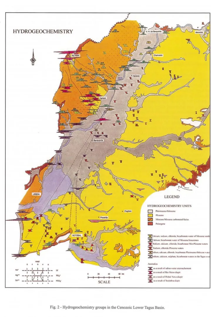
The representation in the Stiff diagram o f the ground waters main composition shows several groups that are similar in profile but different in dimension. Each group is similar as far as hydrogeochemical facies are concem ed, but d iffers by mineralization , which is more important as the polygonal areas are larger (Fig. 2).
Foreach group, the polygonal area increases according to the drain age capac ity; it shows its evo lution in the salt concentrat ion process, Hence, the mineralization increases from the recharge zones in the eastern and western borders of the basin to the discharge spots along the valley near the cou rse of the main river.
Tectoni cs, lithol og y and topograp hy co ntrol the discharge spots and how the discharge is carried out, either throu gh concentrated springs with big water flows or in a diffuse way with variab le drainage from the deeper layers to thc uppe r aquifer.
T he number and characters of the hydrogeochemical groups o f the aquifer systems arc consequences of: the geo logy ; the loca l and/or reg iona l flow sys tem; thc localization of the recharge areas; the mixing of diffe rent ground waters; the influence of the Rio Maior and Pinhal No vo diap irs; the re utili zation of g ro und wate r in a g ricultura l, all uv ium areas ; the sa line- wa te r encroac hement; and (in a lesser scale) contamination.
On the Tagus left riverbank the ground wate r flows from the eas tern bor der (recharge zone), where wa ter mincralization is lower (80 mg/L), Minerali zation values are high er (at lcast 390 mg/L) towards the central part of the valley.
T he E-W water flow (recharge) infiltrates at Abra ntes, Ponte de Sor, Chouto and Lavrc. It moves to the center of the valley towards smaller gradients. It is forced to come to the surface and deal with the natural barrier formed by the less permeable Mioce ne deposits. Its course then depends on the active faults of the Tagus valley. Discharge takes place at Ulme, Almeirim, Alpiarca, Salvaterra, Gloria do Ribatej o, Benavente and A lcoc hete; the aquifer variations in these areas are confi ned (a t Alme irim , A lp ia rca , Sa lv atc rra , G loria a nd Be naven te) and semiconfined (at Ulme and Alcochete).
Taking in to account the silica levels (60 mg/L) and temperature (270C)in the discharge zone, one can assume that the ground water flow mightreach, especially at Alpiarca, where the impermeab le rock substratum is located at a 1495 m depth (by use of the silica geo the rmomcter, Fourn ier&Truesdell formula, 1974 m, for the cristobalite and considering a geothermic gradient of 33 m and an ave rage year temperature of 16,50 C).This estimate is
Ciencias daTerra( UNLJ, 15
HYDROGEOCHEMISTRY
-
,
.... __,- _ I I I _ L_ a'
yt"
- - :- - :~
- I'- -
so.'Co" _ _
I__~z:::I::S[_I
__
~ ."
..
I
SCA LE
.,-..
~LEGEND
IIYI ) K ( X j l: O ClII ~:\ I I ST K Y UNIIS
D PlCt>l"...·"~·lldo<;cnor
D P"<'aIW
IZJ ~ bc>,; _~l , "" _. · ~ r..:.n
P.ln'fCIW
~ · .al(, _ ..-.do ...doI-«.hoc~ ..al,.O( .\ I..'~~
~ · ak Ma. I>t( ...to.:.a ", .. _ olMI....~ 1,____
X · ...,...cotl "' .~ .M~ \I" ..P1. ~ ..Il~
:x.
ScO"",,c.l &rn..ceee..n C"~ GIk> _ , N ~ , ~ ~ "' I w.-.: ...,
%....w...~ '1""' ._phMe.hl(.t-._...~ ,nIIW1.,..n.
X ....w.ullolwl: __...Ilcr~ . .1
X ~ ..ll'\ullo(lttt, \r.rcdr.ar't
X ....~ 'olf"t, lIIuIl ' ...o o1ap<f
:X n " rN l c( ~ m K " .:...;u
However, the evolution of the physical and chemical composition of these waters is disrupted by an anomaly related to salt deposits of the Pinhal Novo diapir. In an 8 m deep well at Lagamecas (Poceirao) , water presented high mineralization values (1244 mgfL) and high levels of chloride (685,7 mg/L), sodium (230 mgfL), sulphate (71,6 mgfL) and magnesium (84,5 mgfL). This only can be explained because Pinhal Novo diapir is very close by. The deep circulating water that contacts evaporites can surface through the Palmela faults and disperse itself in the Pliocene sands. Mixture with ground water from upper aquifers occurs, although upper aquifers are conditioned by gradients and permeability; the sodium chloride water at Lavre is an example. Supporting this corroborating viewpoint, we observed a higher mineralization in these waters along with a higher silica concentration (23,6 mg/ L) which decreases (16,9 mg/L) with dilution.
In the Senibal Peninsula, an anomalous situation also results from the mixture ofwaters from the Pliocene sands and the Miocene limestones with different composition. The small thickness of Pliocene units and their great permeability explain this fact. Taking into account the upper sand levels and the overexploitation of the aquifer, waters of intermediate composition are common in this region.
On the right Tagus riverbank, two aquifers must be taken into account. One lies at subsurface, with transversal W-E flow into the axis basin formed by medium and Upper Miocene limestones at Almoster, Alcobertas, Mocarria, Marmeleira, Santarem, Alenquer, Ota, Alcanena and Torres Novas .Itis characterized by calcium bicarbo-nate waters with mineralization between 400 and 900 mg/ L. Another deeper, N-S aquifer is formed by lower Miocene sandstone deposits between Pernes and Vila Nova da Rainha.
In the Cartaxo region a composition that is not characteristic of the Miocene units occurs. In this region, Miocene units are cut by NW-SE faults that cross Rio Maior. There is a sodium chloride water with chlorid levels that attain 121 mg/L. This phenomenon can not be explained by saline-water encroachement because the sea is too far away.Itis due to the mixture ofsalty waters that flow from Rio Maior.
As far as Pleistocene-Holocene units are concerned , surface waters of wells show abnormally high mineralization levels that exceed those of deeper aquifers in the same area. This occurs in agricultural zones irrigated
Ciencias da Terra (UNL), 15
by ground waters, The systematic re-use ofground waters explains the higher concentration of sulphate, chloride , bicarbonate and calcium.
Above Santarem, connectionsbetween river and aquifer have only been recognized at the alluvium level, where waters are similar in sulphate and magnesium contents.
In the Tagus river upstream of the tidel range at Vila Franca de Xira, water composition seems to be constant. This is typical of a river with a big flow. However, the waters mineralization decreases betweeen Vila Franca de Xira and Santarem, as a consequence of the arrival to the river of, less mineralized waters from both riverbanks.
Inspite of the association in groups ofthe Lower Tagus ground waters based on the Stiff diagrams, their ionic classification (according to Pipe) varies little. Sodium bicarbonate and/or calcium waters predominate, except in the detritic zone where mineralization is lower and they can be grouped in the chlorid/sodi um branch. Near the Tagus and the Sado estuaries there are hydrochemical structures related to saline-water encroachement; the water is sodium chloride rich in these areas.
The dispersion in the distribution of the dots in the diagram is broad (Fig. 3). This results from the lack of clear borders between the aquifers, of anisotropy, heterogeneity and of mixture of different origin waters.
Waters from the Pliocene vary between the bicarbonate and/or sodium chloride; those from the Miocene are mainly calcium bicarbonate, but there is much variation between sodium bicarbonate and sodium chloride or calcium.
For the Pleistocene-Holocene, chemical water characters are very similar to those from the Miocene. These are mainly calcium biocarbonate waters. That sometimes change into calcium chloride ones.
Conclusions
The study ofthe ground waters physical and chemical characters confirm the relationships between the hydrogeochemical groups established for the aquifer system and Geology aspects, the flow system, the location of recharge areas, the mixing waters of different qualities and several origins, the proximity of diapirs agricultural regions, saline-waters encroachement in coastal areas, and contamination sources.
Citncias da Terra (UN L). 15
60
'"
•
- ~•
...
•
Plestocene-l lclloc-...•
Tagus's Wlt er•
0_.
_.
IIjg - anCIINly
60
Calciom
Bicarbonat e wat er
20
"
o
•
00 Sodium
Chloride and
Sulpha te water
c
60 ec
Fig. 3· Trilinear diagram of water analysis from the aquifer system o f the LowerTagus Basin.
References
Andrade, C. B.F.(1933) · ArectonicadoestuaricdoTejo e dos vales submarinos ao largo da CostadeCaparica.Com.Serv:Geol. Ponugal,Lisboa., XIX.
Antunes, M. T. ( 197 5)- lbe rosuchUJ.crocodile Sebecosuchien nouveau.,l'Bocene iberique au Norddelaehaine Centrale et l'origine du canyondeNazare.Com.Serv.Geol. Portuga l.Lisboa , LIX: 285·330.
Antunes, M. T. (1979 ) - Alguns aspectosdoNeocretscicc e do Paleogenico em Portugal.Ciencias Terra(UNL).Lisboa, 5.
Antunes. M. T. ( 1983) . Petits mam miferesde la fin du Miocene moyen dans les depots marins de CerradodaPedra, Ald cer doSal. Com.Serv.Geol. de Portugal.lisboa, 69(2) : 373-379.
Antunes , M.T.( 1986) .Paraloph iodon cf. /eptorhynch um(tapiroidea, mammalia)i Vale Furado: contribution
a
la connaissance de " Eocene au Portu gal.Ctenctas Terra (UNL).Lisboa , 8:87-98.Antunes, M. T. (2000 ) . Miocene marine mamma ls from Lisbon and geologic age. A showcase for mari ne-continental corre lations. Cti notas Terra (UNL) ,Lisboa, 14: 343-3 48.
Ciencias da Terra(UNL), 15
Antunes, M. T. &Ginsburg, L. (2000) - Les Perissodactyles (Mammalia) du Miocene de Lisbonne.Ciencias Terra (UNL),Lisboa , 14: 349-355.
Antunes, M. T. & Ginsburg, L. (2000) - Presence du CreodonteHyainailouros sulzeridans Ie Miocene du bass in du Bas Tage (Lisbonne, Portugal).Ciencias Terra (UNL),Lisboa, 14: 355-358.
Antunes, M. T.& Pais, J. (1978) - Notas sobre depositos de Taveiro. Estudo paleontologico, idade, paleoecologia.Ciencias Terra (UNL),Lisboa , 4.
Antunes, M. T.& Pais,J.(1983) - Climate During Miocene in Portugal and its evolution. Mediterranean Neogene continental paleoenvironments and paleoclimatic evolution.R.C.M N.S.Interim-Colloquium,Montpellier. 19-22.
Barbosa, B.A.P. S. (1995) -Alostratigrafia e Litostratigrafia das unidades continentais da bacia tercidria do Ba ixo Tejo-Relaciies com0Eustatismo e a Tectonica.Dissertacao de Doutoramento, Universidade de Lisboa, 253 p.
Barbosa, B.&Reis, R. P. dos (1996) - Geometrias de enchimento, sistemas deposicionais e organizacao estratigrafica do Pliocenico continental da Bacia Terciaria do Baixo Tejo (Portugal).Com. Inst. Geologico Mineiro,Lisboa, 82: 51-86.
Choffat, P. (1908) - Essai sur la tectonique de la Chaine de l'Arrabida,Comm. ServoGeol. Portugal,Lisboa .
Choffat, P. (1950) - Geologie du Cenozolque du Portugal.Com. Serv. Geol. de Portugal.,Lisboa, Supl. ao T. XXX: 1-182.
Cotter, J. C. B. (1956) -0 Miocenico marinho de Lisboa (publicacao postuma),Com. Servo Geol. Portugal,Lisboa, XXXVI: 9-170.
Fleury, E. (1936) - As ultimas grandes evolucoes geologicas do Ribatejo.Bal. Junta Geral Distrito Santarem , 23 .
Ribeiro, A.; Antunes, M. T.; Ferreira, M. P.; Rocha, R. B.; Soares, A.F.;Zbyszewski, G; Moitinho de Almeida,F.;Carvalho, D.&
Monteiro, J. H. (1979) - Introductionitla geologie generale du Portugal.Serv. Geol. Portugal, Lisboa , 114 p.
Simoes, M. M. (1998) -Contribuiciio para()conhecimento hidrogeologico do Cenozoico na Bacia do Baixo Tejo.Dissertacao de Doutoramento, Universidade de Nova de Lisboa, 270 p.
Zbyszewski, G (1946) - Etude geologique de la region d'Alpiarca,Com. ServoGeol. Portugal,Lisboa, XXVII.