UNIVERSIDADE DE SÃO PAULO INSTITUTO DE GEOCIÊNCIAS
CLIMATIC EVOLUTION OF EASTERN SOUTH AMERICA DURING THE LAST DEGLACIATION: A PALEOCEANOGRAPHIC APPROACH
Maria Carolina Amorim Catunda
Orientador: Prof. Dr. Cristiano Mazur Chiessi
DISSERTAÇÃO DE MESTRADO
Programa de Pós-Graduação em Geoquímica e Geotectônica
versão corrigida SÃO PAULO
Autorizo a reprodução e divulgação total ou parcial deste trabalho, por qualquer meio convencional ou eletrônico, para fins de estudo e pesquisa, desde que citada a fonte.
Ficha catalográfica preparada pelo Serviço de Biblioteca e Documentação do Instituto de Geociências da Universidade de São Paulo
Catunda, Maria Carolina Amorim
Evolução do clima do leste da América do Sul
durante a última deglaciação: uma abordagem
paleoceanográfica / Maria Carolina Amorim Catunda.
– São Paulo, 2015.
125 p.: il + anexos
Dissertação (Mestrado) : IGc/USP
Orient.: Chiessi, Cristiano Mazur
1. Paleoclimatologia 2. Paleoceanografia 3.
To my loved ones.
i
Acknowledgements
/ Agradecimentos
I’d like to dedicate this dissertation to my parents, Maria Alice and Heitor for the support and love, which allowed me to pursue my aspirations, and to my dear brothers, Gustavo and Arthur, for being by my side. I thank my deeply loved friends, the old and the new, for the help and understanding, as well as for the good times and laughs. I thank my love, Daniel Rodelli, for making my life brighter.
To my official supervisor, Dr. Cristiano Chiessi, thank you for the opportunities and patience. To my unofficial supervisors Chico Bill and Dr. Juan Pablo Bernal, thank you for believing in me.
I thank my Brazilian colleagues, Adriana Perretti (:*), Marília Campos, Stefano Crivellari, Igor Venâncio, Thiago dos Santos, Cintia Yamashita and Nancy Kazumi for the productive discussions about work and life. To my friends in Bremen Melanie Schneider, Itxaso Ruiz, Barbara Safaric and Jessica Volz, thank you for making me feel at home. I thank Dr. Stefan Mulitza and Dr. Nicolás Strikis, for our conversations and scientific discussions that helped develop this dissertation.
ii
Abstract
To support the current debate and actions to be taken about climatic consequences of anthropogenic release of CO2, a refined understanding about past climatic and oceanographic
changes is necessary. The Atlantic Meridional Overturning Circulation (AMOC) plays a fundamental role in the oceanography and climate of the Atlantic realm, directly controlling stratification and distribution of water masses, the amount of heat that is transported by the ocean, and the cycling and storage of chemical species, such as carbon dioxide in the deep sea. The formation and circulation of Antarctic Intermediate Water (AAIW) is an important component of the upper branch of the AMOC, involved in the transport of heat and salt within the Southern Hemisphere subtropical gyre and driving high–low latitude climatic teleconnections. Reconstructing intermediate water properties is, therefore, important for understanding feedbacks within the ocean-climate system. However, information on AAIW evolution remains limited. AMOC oscillations and changes in heat distribution have strong implications for the South American climate, influencing moisture influx availability for the South American Summer Monsoon (SASM), via sea surface temperatures and Intertropical Convergence Zone positioning. Here we reconstruct AAIW isotopic signature during marine isotope stages 2 and 3 (41-12 cal kyr BP) using carbon and oxygen isotopes from benthic foraminifera (Cibicidoides and Uvigerina genera) of a radiocarbon dated marine sediment core (1100m water depth and 20S, off the Brazilian coast). We find that AAIW’s physical and chemical properties changed Heinrich stadials 3 and 4, probably as a consequence of AMOC decreased strength during these periods. We also reconstruct Last Glacial Maximum and deglacial (23-12 cal kyr BP) continental conditions over eastern Brazil based on Ti/Ca of our marine sediment core as a proxy for Doce River (draining eastern Brazil) terrigenous input. Most of the rainfall in the Doce River Basin is related to the activity of the SASM. Our Ti/Ca record together with a speleothem 18O composite from Lapa Sem Fim Cave, also in
eastern Brazil, suggests a major decrease in precipitation during the Bølling–Allerød interstadial, likely related to a weakening of the SASM. We further compared our Ti/Ca results with the output of the SYNTRACE run of the CCSM3 fully-coupled climate model with transient forcing for the last deglaciation. Geochemical records and model output show consistent results and suggest that eastern South America experienced the driest period of the whole last deglaciation during the Bølling–Allerød and that this dry spell was likely related to decreased SAMS intensity.
iii
Resumo
Para dar suporte ao atual debate sobre as consequências climáticas da liberação antropogênica de CO2 na atmosfera, o refinamento do conhecimento sobre mudanças
climáticas e oceanográficas no passado é necessário. A Circulação de Revolvimento Meridional do Atlântico (CRMA) tem papel fundamental na oceanografia e clima das áreas sob influência do Oceano Atlântico, controlando diretamente a estratificação e distribuição de massas d’água, a quantidade de calor transportada pelo oceano e os ciclo e armazenamento de compostos químicos, como o CO2 em mar profundo. A formação e circulação da Água
Intermediária Antártica (AIA), envolvida no transporte de calor e sal para o giro subtropical do Hemisfério Sul e nas teleconexões climáticas entre altas e baixas latitudes, é componente importante do ramo superior da CRMA. A reconstrução de propriedades de massas de água intermediárias é, portanto, importante para a compreensão dos sistemas de retroalimentação entre oceano-clima. No entanto, informações quanto a evolução da AIA continuam limitadas. Oscilações da CRMA e consequentes mudanças na distribuição de calor tem implicações importantes para o clima Sul Americano, influenciando a disponibilidade de umidade para o Sistema de Monções Sul Americano (SMSA), via temperatura da superfície marinha e posicionamento da Zona de Convergência Intertropical. Neste trabalho nós reconstruímos a assinatura isotópica da AIA durante os estágios isotópicos marinhos 2 e 3 (41-12 cal ka AP) usando isótopos de carbono e oxigênio de foraminíferos bentônicos (gêneros Cibicidoides e
Uvigerina) de um testemunho de sedimentos marinhos datados por radiocarbono (1100 m de profundidade e a 20S na costa do Brasil). Concluímos que propriedades físicas e químicas da AIA mudaram durante os estadiais Heinrich 3 e 4, provavelmente como consequência de enfraquecimento da CRMA durante estes períodos. Também reconstruímos as condições continentais do leste brasileiro entre o último máximo glacial e a deglaciação (23-12 cal ka AP) baseadas em razões Ti/Ca de nosso testemunho de sedimentos marinhos como indicadoras de aporte terrígeno do Rio Doce. A maior parte da chuva que cai na Bacia do Rio Doce está relacionada a atividade do SMAS. Nosso registro de Ti/Ca em conjunto com 18O
de espeleotemas da Caverna Lapa Sem Fim, também no leste do Brasil, sugere diminuição marcante da chuva durante o interestadial Bølling–Allerød, provavelmente relacionada a enfraquecimento do SMAS. Ademais comparamos as razões de Ti/Ca com dados de saída da rodada SYNTRACE do modelo climático CCSM3 com forçantes transientes para a última deglaciação. Os registros geoquímicos e a saída do modelo mostram resultados consistentes entre si e sugerem que o leste da América do Sul passou pelo seu período mais seco de toda a última deglaciação durante o interestadial Bølling–Allerød, provavelmente relacionado ao enfraquecimento do SMAS.
iv
List of abbreviations
/ Lista de abreviações
AABW – Antarctic Bottom WaterAAIW – Antarctic Intermediate Water
AMOC – Atlantic Meridional Overturning Circulation AMS – Accelerator mass spectrometry
BA – Bølling-Allerød Interstadial Ca – Calcium
CDW – Circumpolar Deep Water CO2 – Carbon dioxide
Corg– Organic carbon
DO – Dansgaard-Oeschger Interstadial DIC – Dissolved inorganic carbon
13C – Isotopic ratio of 13C relatively to 12C
13C
c - 13C of Cibicidoides spp. samples
δ13C
as–13C on foraminiferal calcite due to air-sea fractionation processes
13C
u - 13C of U. peregrina samples
18O – Isotopic ratio of 18O relatively to 16O
18O
c - 18O of Cibicidoides spp. samples
18O
civc– Ice volume corrected 18O of Cibicidoides spp. samples
18O
u - 18O of U. peregrina samples
18O
uivc - Ice volume corrected 18O of U. peregrina samples
δ13C – variable offset between δ13C
c and δ13Cu
offset - difference between glacial δ13C and interglacial δ13C
EDP-XRF - Energy dispersive X-ray fluorescence
Fe – Iron
GAAIW – Glacial Antarctic Intermediate Water GNAIW – Glacial North Atlantic Intermediate Water HS – Heinrich Stadial
v
JAS – July, August and September (austral winter) JFM – January, February and March (austral summer)
ka – kilo annum / calibrated kilo years before present (1950) LCDW – Lower Circumpolar Deep Water
LGM – Last Glacial Maximum MIS – Marine Isotope Stage mbsl – meters below sea level
NADW – North Atlantic Deep Water NBC – North Brazil Current
NH – Northern Hemisphere OD – Older Dryas
OLD – Oldest Dryas
P2L – Paleoceanography and Paleoclimatology Laboratory at the School of Arts, Sciences and
Humanities of the University of São Paulo, Brazil
SA – South America
SACW – South Atlantic Central Water SACZ – South Atlantic Convergence Zone SH – Southern Hemisphere
SASM – South American Summer Monsoon SSG – (Atlantic) Southern Subtropical Gyre SST – Sea surface temperature
Ti – Titanium
UCDW – Upper Circumpolar Deep Water VPDB – Vienna Pee Dee Belemnite XRF – X-ray fluorescence
vi
List of Figures /
Lista de Figuras
Figure 2.1: Global termohaline circulation...4
Figure 2.2: Position of the Atlantic latitudinal section and main characteristics of Atlantic water masses... 5
Figure 2.3: Monthly long term mean sea surface temperature (SST) and monthly long term mean precipitation...7
Figure 2.4: Predominant AMOC modes as derived from the combined 231Pa/230Th records...10
Figure 2.5: Comparison of δ13C distribution along the western Atlantic for the modern ocean
(GEOSECS) and during the Last Glacial Maximum...11
Figure 2.6: Proxy records spanning from 10 to 70 cal kyr BP that demonstrate the close relationship between Greenland temperatures and rainfall records from the tropical Atlantic and China during the last glacial period...13
Figure 3.1: Location of the Doce River Basin (black line) and marine sediment cores GeoB3227-2 (1340 mbsl) and GeoB3228-1 (1095 mbsl)...18
Figure 3.2: Doce River Canyon System and the location of marine sediment cores GeoB3228-1 and GeoB3227-2...19
Figure 3.3: Schematic representation of the large-scale, upper level geostrophic currents and fronts in the South Atlantic Ocean...21
Figure 3.4: Properties of the water column in the study area... 22
Figure 3.5: Histograms of monthly precipitation at selected stations from the Doce River drainage basin and mean annual cycle of the Doce River discharge...24
Figure 4.1. General color and sampling schematics of marine sediment cores GeoB3228-1 and GeoB3227-2...26
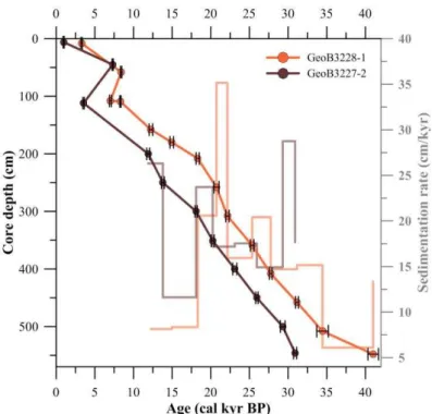
Figure 5.1: Age models and sedimentation rates for marine sediment cores GeoB3228-1 and GeoB3227-2...35
Figure 5.2: Benthic foraminiferal stable oxygen and carbon isotopic records for the uppermost half of marine sediment core GeoB3228-1, divided by species... 39
Figure 5.3: Benthic foraminiferal stable oxygen and carbon isotopic records for marine sediment core GeoB3228-1......40
Figure 5.4: Benthic foraminiferal stable oxygen and carbon isotopic records for uppermost half of marine sediment core GeoB3228-1, divided by species...41
Figure 5.5: Ti/Ca and Fe/Ca records from cores GeoB3228-1 and GeoB3227-2...44
Figure 6.1: Relative sea level (Lambeck and Chappel, 2001; updated in 2007) and ln(Fe/Ca) of GeoB3228-1 and GeoB3227-2 versus age...46
Figure 6.2: Ice volume corrected Cibicidoides δ18O composite interpolated every 1kyr; C.
wuellerstorfi, C. pachyderma, Cibicides spp. and Cibicidoides spp. δ18O record and 1 kyr
integrated interpolation; ice volume corrected U. peregrina δ18O record interpolated every 1kyr;
U. peregrina δ18O record and 1 kyr integrated interpolation; antarctic temperature stack from
vii
Figure 6.3: C. wuellerstorfi, C. pachyderma, Cibicides spp. and Cibicidoides spp. δ13C record and 1
kyr integrated interpolation; U. peregrina δ13C record and 1 kyr integrated interpolation;
antarctic composite ice core atmospheric CO2 data (WAIS, Siple Dome and TALDICE)...51
Figure 6.4: Comparison between 1 kyr integrated interpolations of GeoB3228-1 U. peregrina δ13C
record and Antarctic ice core atmospheric CO2 data composite...55
List of Tables
/ Lista de Tabelas
Table 3.1. Data from the selected monitoring stations for which histograms are shown in Figure 3.5...23
Table 4.1 Results of the preliminary selection of benthic foraminifera from core GeoB3228-1, considering the genera Cibicidoides/Cibicides and Uvigerina...28
viii
Summary / Índice
Acknowledgements / Agradecimentos ... i
Abstract ... ii
Resumo ... iii
List of abbreviations / Lista de abreviações ... iv
List of Figures / Lista de Figuras ... vi
List of Tables / Lista de Tabelas ... vii
1. Introduction and objectives / Introdução e objetivos ... 1
Introduction / Introdução ... 1
Objectives / Objetivos ... 2
2. State of the art / Revisão bibliográfica ... 3
Modern oceanography and climate / Oceanografia e climatologia modernas ... 3
2.1.1. The modern Atlantic Meridional Overturning Circulation / A Célula de Revolvimento Meridional do Atlântico no presente ... 3
2.1.2. Modern influence of the Intertropical Convergence Zone and insolation over the South American Monsoon System / Influência atual da Zona de Convergência Intertropical e insolação sobre o Sistema de Monções da América do Sul ... 5
Paleoceanography and paleoclimatology / Paleoceanografia e paleoclimatologia .... 8
2.2.1. Atlantic Meridional Overturning Circulation oscillations during the Last Glacial Maximum and Termination I / Oscilações da Célula de Revolvimento Meridional do Atlântico durante o Último Máximo Glacial e a Terminação I ... 8
2.2.2. Water masses on the Brazil continental margin during the Last Glacial Maximum
ix 2.2.3. Millenial scale climate oscillations during late glacial and Termination I /
Oscilações climáticas de escala milenar durante a porção final do último período glacial e a Terminação I ... 12
2.2.4. The Bølling - Allerød Interstadial/ O Interestadial Bølling-Allerød ... 14
3. Study area, modern oceanography and climatology / Área de estudo, oceanografia e climatologia modernas ... 17
Study area / Área de estudo ... 17
Modern oceanography of the western South Atlantic adjacent to the Doce River shelf / Oceanografia moderna do oeste do Atlântico Sul adjacente à plataforma do Rio Doce . 20
Modern climatology of Doce River basin / Climatologia moderna da Bacia do Rio Doce 23
4. Materials and methods / Materiais e métodos ... 25
Materials - Marine sediment cores / Materiais - Testemunhos sedimentares marinhos
25
Methods / Métodos ... 25
4.2.1. Marine sediment cores visual evaluation, sampling and sample processing / Avaliação visual dos testemunhos de sedimento marinho, amostragem e processamento das amostras... 25
4.2.2. AMS radiocarbon dating and age models / Datações radiocarbônicas AMS e modelos de idade ... 27
4.2.3. Benthic foraminifera selection strategy / Estratégia para seleção de foraminíferos bentônicos ... 27
4.2.4. δ18O and δ13C of benthic foraminifera / δ18O e δ13C de foraminíferos bentônicos 29
4.2.5. Fe/Ca and Ti/Ca ratios in oceanic basins as paleoclimatological proxies / Razões Fe/Ca e Ti/Ca como indicadores paleoclimáticos ... 33
x
5. Results / Resultados ... 35
Radiocarbon ages and age models / Idades radiocarbônicas e modelos de idade .... 35
δ18O and δ13C of benthic foraminifera / δ18O e δ13C de foraminíferos bentônicos .... 37
Major elements in bulk sediment / Elementos maiores em sedimento total ... 42
6. Discussion / Discussão ... 46
Sedimentation on the core sites on the passage between the late Pleistocene and Holocene / Sedimentação no local dos testemunhos marinhos durante a passagem Pleistoceno tardio e Holoceno ... 46
Changes in southern sourced water masses isotopic signature in the western South Atlantic during the late glacial and Termination I ... 47
South American summer monsoon decreased intensity related to the Bølling-Allerød interstadial / Diminuição da intensidade do Sistema de monções de verão Sul Americano relacionado ao interestadial Bølling-Allerød... 55
7. Conclusions / Conclusões ... 56
8. References / Referências Bibliográficas... 57
1
1.
Introduction and objectives
/ Introdução e objetivos
Introduction
/ Introdução
The Atlantic Meridional Overturning Circulation (AMOC) plays a fundamental role in the oceanography and climate of the Atlantic realm. As such, AMOC activity directly controls stratification and distribution of water masses, the amount of heat that is transported by the ocean, and the cycling and storage of chemical species, such as carbon dioxide (CO2) in the
deep sea (Kuhlbrodt et al., 2007).Past changes in global atmospheric CO2 concentrations over interglacial and glacial cycles may have been driven by changes in ventilation and circulation of intermediate and deep waters (e.g., Siegenthaler and Wenk, 1984).
The formation and circulation of Antarctic Intermediate Water (AAIW) is an important component of the upper branch of the AMOC, involved in the transport of heat and salt within the Southern Hemisphere (SH) subtropical gyre (Talley, 1996). Upon its formation on the Subantarctic Frontal Zone, AAIW sequesters significant quantities of CO2 (Talley, 1996;
Sabine et al., 2004), which are then widely distributed in SH oceans (Lynch-Stieglitz et al., 1994). Reconstructing intermediate water properties is, therefore, important for understanding feedbacks within the ocean-climate system. However, information on intermediate water mass evolution remains limited (Elmore et al., 2015).
The South American Summer Monsoon (SASM) is one of the major monsoon systems in the SH and the most important climatic feature in South America (SA; Vera et al., 2006; Carvalho et al., 2012). Its strength is dependent on insolation with moisture availability modulated by Intertropical Convergence Zone (ITCZ) positioning (Vera et al., 2006). Given that the former is controlled by sea surface temperatures (SST; Nobre and Shukla, 1996), AMOC oscillations and changes in heat distribution have strong implications for the South American climate.
Deglaciation periods offer the possibility to study in detail the impact of rapid climatic
changes on the environment (Wohlfarth, 1996). The last deglaciation, or Termination I,
started between 20 and 18 kyr ago in the SH with continuous increase in temperature and
greenhouse gas concentration (Petit et al., 1999; Marcott et al., 2014). For over 3 kyr
2
Hemisphere (NH) cold period between 18.1 and 14.7, known as Heinrich stadial 1 (HS1),
ended abruptly at the start of the Bølling–Allerød interstadial (Rasmussen et al., 2006). This
abrupt transition was marked by the restart of the AMOC (McManus et al., 2004) and
warming in NH (Petit et al., 1999), with a corresponding return to cold conditions in the south
(Blunier et al., 1997).
Previous studies have correlated pulses of terrigenous input with cold events in the NH off the coast of generally dry northeastern SA (Arz et al., 1998; Arz et al., 1999; Jennerjahn et al., 2004; Jaeschke et al., 2007; Nace et al., 2014). Yet, the 23-7ºS sector of the Brazilian continental margin remains completely void of studies. This is a particularly relevant sector of the continental margin for reconstructing the strength of the SASM. Oxygen isotopic oscillations from stalagmites have provided a glimpse of how continental climate responded to past millennial scale abrupt events (Wang et al., 2008a; Stríkis et al., 2015). However the several other areas of the continent and proximal marine environments are still not resolved.
The mere possibility that the AMOC could change was already a strong motivator to understand how it may have oscillated in the past (Lynch-Stieglitz et al., 2007). A recent study confirmed that the AMOC is currently weakening (Rahmstorf et al., 2015), highlighting the urgency of researching about the impacts of past AMOC strength oscillations and abrupt climatic events during the glacial and deglacial periods.
Objectives
/ Objetivos
The main objectives of this dissertation are:
(i) Investigate the isotopic evolution of southern sourced water masses (i.e., AAIW, UCDW and their glacial correspondents) in the western tropical South Atlantic throughout the last glacial and Termination I, and suggest its driving mechanisms;
3
2.
State of the art
/ Revisão bibliográfica
Modern oceanography and climate
/
Oceanografia e climatologia
modernas
2.1.1. The modern Atlantic Meridional Overturning Circulation / A Célula de
Revolvimento Meridional do Atlântico no presente
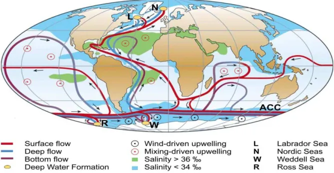
The Atlantic Meridional Overturning Circulation (AMOC), correspondent to the Atlantic section of the global termohaline circulation, plays a fundamental role in the oceanography and climate of the Atlantic realm. The ocean affects climate through its high heat capacity relative to the surrounding land, thereby moderating daily, seasonal and interannual temperature fluctuations, and through its ability to transport large amounts of heat polewards, whereas freshwater input to high latitudes and low-latitude evaporation tend to brake this flow (Clark et al., 2002). The AMOC is responsible for much of the total oceanic poleward heat transport in the Atlantic, peaking at about 1.2 ± 0.3 PW (1 PW equals 1015
Watts) at 24ºN (Ganachaud and Wunsch, 2000). The northward-flowing Atlantic surface waters are warm, whereas the southward-flowing deep waters are cold defining a meridional heat flux and a net northward transport of heat (Figure 2.1).
The AMOC activity directly controls stratification and distribution of water masses, the amount of heat that is transported by the ocean, and the cycling and storage of chemical species, such as carbon dioxide (CO2) in the deep sea (Kuhlbrodt et al., 2007). It can be
4
Warm and saline waters from the Southern Subtropical Gyre (SSG), with contribution of the waters brought by the Agulhas Current from the Indian Ocean, cross the Equator via the North Brazil Current (NBC), and ultimately contribute to the northward flowing Gulf Stream. At high latitudes of the North Atlantic, these high salinity surface and intermediate waters lose buoyancy as they transmit heat to the atmosphere and sink forming the southward flowing NADW.
Deep-water formation in the Southern Ocean occurs along the Antarctic continental shelf in the Weddell and Ross Seas either through intense evaporation or, more typically, through brine rejection that produces dense waters that sink along the slope (Killworth, 1983).
As a result, the North Atlantic surface is relatively warmer and saltier than its equivalent in the South Atlantic. South of the Equator, the nutrient poor NADW occupies from 1500 to 4000 m water depth and lies within the density range of the northward flowing Circumpolar Deep Water (CDW). The latter is then divided in two layers: Upper Circumpolar Deep Water (UCDW) and Lower Circumpolar Deep Water (LCDW), each of them less saline, richer in nutrients and lower in oxygen than NADW (Reid et al., 1977; Figure 2.2). UCDW is defined as a local oxygen and temperature minimum located below the salinity minimum and local oxygen maximum characteristic of the Antarctic Intermediate Water (AAIW; Tsuchiya and Talley, 1994). Under LCDW, AABW bathes the South Atlantic sea floor below 4000 m with cold and nutrient rich waters (Figure 2.2).
5 2.1.2. Modern influence of the Intertropical Convergence Zone and insolation over the
South American Monsoon System / Influência atual da Zona de Convergência
Intertropical e insolação sobre o Sistema de Monções da América do Sul
The Intertropical Convergence Zone (ITCZ) corresponds to a tropical belt of minimum pressure and deep convergence of the trade winds from both hemispheres over the equatorial oceans (Figure 2.3). It migrates seasonally towards the hemisphere being warmed in relationship to the other, shifting latitudinally in response to zonal sea surface temperatures (SST) gradients, which itself contributes to the distribution of sea level pressure and winds Figure 2.2: (a) Position of the Atlantic latitudinal section and (b, c, and d) main characteristics of Atlantic water masses. (b) Long-term mean salinity along the Atlantic (color-scale shading) (Zweng et al., 2014); (c) Long-term mean oxygen along the Atlantic (color-scale shading) (Garcia et al., 2014a); (d) Long-term mean phosphate along the Atlantic (color-scale shading) (Garcia et al.,
2014b). Water masses are shown schematically by their acronyms: AABW – Antarctic Bottom
Water, AAIW – Antarctic Intermediate Water, LCDW – Lower Circumpolar Deep Water, NADW –
North Atlantic Deep Water, and, UCDW – Upper Circumpolar Deep Water. This figure was prepared
6
(Nobre and Shukla, 1996; Chiang and Kushnir, 2002; Schneider et al., 2014). The Atlantic section of the ITCZ migrates seasonally reaching its northernmost location, 10°N, in August and southernmost, 1°S, in March (mean latitudes at longitude 30°W; Nobre and Shukla, 1996). Nevertheless, it has been suggested that during abrupt cooling events on the Northern Hemisphere (NH) it migrated further southward of the Equator (e.g., Deplazes et al., 2013).
The South American Summer Monsoon (SASM) has its onset in October, when moisture influx to the Amazon Basin from the Atlantic Ocean is intensified due to increased
thermal gradients between land and sea, stronger trade winds, and the southward shift on the ITCZ position (Vera et al., 2006). Efficient transport of humidity from the Tropical Atlantic
into South America (SA), reaches the Amazon Basin, where intense convective activity takes place.
The SASM most active phase is between December and February (austral summer), when a deep continental low forms over the Chaco region (due to insolation increase in the Southern Hemisphere, around 25°S; Seluchi et al., 2003) and forces the easterly winds over the Amazon basin to turn southward, channeled via Low Level Jets (LLJ) between the eastern slope of the Andes and the Brazilian Plateau (Garreaud et al., 2009). During this peak phase, a prominent warm-core anticyclone establishes itself over the elevated Altiplano of the central Andes, the Bolivian High (BH), defined by Lenters and Cook (1997) as “a collective response to precipitation in the Amazon, central Andes, and South Atlantic Convergence Zone (SACZ), with its position over the Altiplano being largely the result of Amazonian precipitation”. The latent heat release over the Amazon Basin and the establishment of the BH are also connected to the development of SACZ, a transient convective system characterized by a NW-SE nebulosity band formed by transport of Amazon moisture via LLJ to southeastern SA (Figure 2.3) and the Atlantic (Liebmann et al., 1999; Carvalho et al., 2004; Vera et al., 2006). The intensity of the SASM is mainly influenced by insolation, which is
modulated by precession and excentricity, and by the dynamics of the ITCZ. Higher (lower)
austral summer insolation over the Southern Hemisphere (SH) strengthens (weakens) the
monsoon system by increasing (decreasing) the land-sea thermal gradient. On the other hand,
the ITCZ position modulates the amount of humidity influx to the Amazon Basin and
southeastern SA. The SASM has its demise in April (Marengo et al., 2001; Raia and
7
8
During the austral winter, central SA (including southern Amazonia) experiences the
dry season with maximum continental rainfall occurring to the north of the equator. Further south, precipitation is associated with moisture brought by extratropical cyclones and cold fronts (Garreaud et al., 2009).
The SACZ is evident year round but more intense during austral summer (the SASM season), when it is connected with the area of convection over the central part of the continent, producing episodes of intense rainfall over much of southeastern SA (Liebmann et al., 1999). Warm anomalies in SST in subtropical South Atlantic are associated with southward displacement of the SACZ with contributes to increase precipitation over southeastern SA (Diaz et al., 1998; Barros et al., 2000).
Paleoceanography and paleoclimatology
/ Paleoceanografia e
paleoclimatologia
2.2.1. Atlantic Meridional Overturning Circulation oscillations during the Last Glacial
Maximum and Termination I / Oscilações da Célula de Revolvimento Meridional do
Atlântico durante o Último Máximo Glacial e a Terminação I
Extreme, abrupt climate oscillations during the last glacial cycle were modulated by changes in ocean circulation and atmospheric forcing (Rahmstorf, 2002). Data and models both suggest that abrupt climate change during the last glaciation originated through changes in the AMOC in response to changes in the hydrological cycle or freshwater input in the high latitudes of the NH. Atmospheric and oceanic responses to these changes were then transmitted globally through a number of feedbacks (Clark et al., 2002).
9
The existence of different AMOC states in the past has been first proposed and discussed mostly on the basis of nutrient tracers such as δ13C (Sarnthein et al., 1994), that are
inversely correlated to nutrient content and Cd/Ca in tests of benthic foraminifera (see section 4.2.4). Like the major nutrients, Cd is taken up by organisms at the sea surface and released at depth as the organic material is decomposed. The agreement between reconstructions based on these two water-mass tracers provides increased confidence in the overall picture.
Deep and vigorous overturning circulation, similar to the modern state, has persisted for most of the last glacial cycle, dominating the oceanic circulation in the Atlantic (Böhm et al., 2015). During deep glacial conditions (mainly glacial maxima), however, the upper cell of the AMOC may have been weaker and southern-sourced waters (SSW) advanced northwards and upwards in the water column, while NADW sank to depths of less than 2.500 m (Labeyrie et al., 1992). With the decrease of NADW formation, such as during the LGM, high nutrient/low δ13C waters, like the modern SSW (i.e., AAIW, CDW and AABW) may have partially
replaced nutrient poor NADW and a large part of the deep Atlantic Ocean was bathed by deep waters advected from the Southern Ocean (Duplessy et al., 1984; Curry and Oppo, 2005; Lynch-Stieglitz et al., 2007). This shallower NADW is generally termed Glacial North Atlantic Intermediate Water (GNAIW) in paleoceanographic studies.
More significant slowdowns of the AMOC, probably related to iceberg discharges and increased freshwater input at the high latitudes of the NH, happened during Heinrich Stadials (HS; Böhm et al., 2015). The Heinrich-like mode of the AMOC is characterized as a quasi-halt in NADW formation during HS1, for instance (Rahmstorf, 2002; McManus et al., 2004). In contrast, the AMOC remained active during Dansgaard-Oeschger Interstadials (DO), abrupt warm events in the NH defined in ice cores from Greenland (Böhm et al., 2015).
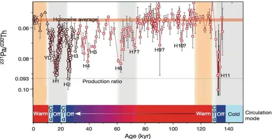
Furthermore, McManus et al. (2004) used measurements of 231Pa/230Th to trace the
strength of the AMOC since the LGM and confirmed that the AMOC was nearly, or completely, eliminated during cold abrupt deglacial intervals in the North Atlantic region, namely HS1 and the Younger Dryas (YD; Figure 2.4).
In the South Atlantic, low δ13C values (correlated with glacial SSW or more specifically
10
al., 2014), early in the deglaciation. While a few studies suggested that greater northward advection of GAAIW during HS1 caused low δ13C at relatively shallow depths (Rickaby et
al., 2005; Pahnke et al., 2008), more recent studies using cores from modern AAIW depths suggest that the northward extent of GAAIW decreased during HS1 and the YD, presumably
in response to a reduced AMOC (Xie et al., 2012; Huang et al., 2014).
It is still not clear if the AMOC has always controlled or at times only responded to abrupt climatic oscillations during the last glacial period (Böhm et al., 2015). Nevertheless,
ice cores show that Antarctica cooled during the major warm phases of the Greenland DO
cycles and vice versa (Blunier and Brook, 2001; EPICA Community Members, 2006), supporting the idea of an interhemispheric redistribution of heat (bipolar seesaw; EPICA
Community Members, 2006; Barker et al., 2009). WAIS Divide Project Members (2015)
results demonstrated north-to-south directionality of the abrupt climatic signal, propagated to
the SH high latitudes by oceanic processes (abrupt Greenland warming led Antarctic cooling
onset by 218 ± 92 years for D–O events, including the Bølling event, and Greenland cooling
led onset of Antarctic warming by 208 ± 96 years).
Figure 2.4: Predominant AMOC modes as derived from the combined 231Pa/230Th records. Figure
extracted from Böhm et al. (2015). Open red squares: Bermuda Rise 231Pa/230Th data. Dark red triangles: 231Pa/230Th data from McManus, 2004. Dark red circles: 231Pa/230Th data from Lippold et
al. 2009. HS1–HS11 mark the timing of major iceberg surges in the North Atlantic (Rasmussen et
11 2.2.2. Water masses on the Brazil continental margin during the Last Glacial
Maximum / Massas de água na margem continental do Brasil durante o Último
Máximo Glacial
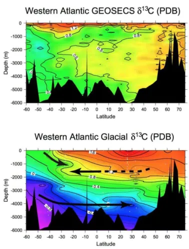
Along the Brazil Margin, South Atlantic δ13C values were much lower than North
Atlantic values at nearly every water depth during the LGM. Curry and Oppo (2005) updated the glacial western Atlantic cross section published by Duplessy et al. (1988) and indicated that above 2000 m, the bathymetric δ13C gradients in the South Atlantic revealed the presence
of two main water masses (Figure 2.5). The shallower, between 800 and 1200 m and centered at 1000 m water depth, was most likely sourced in the Southern Ocean and was interpreted as the glacial equivalent of AAIW (GAAIW). Centered at 1500 m and derived from the north there was another mid depth water mass, interpreted as the southern expression of GNAIW.
12
Still according to Curry and Oppo (2005), at 27ºS and during the LGM, GAAIW had a δ13C value of about 0.3–0.5‰. Oppo and Horowitz (2000) had already identified this water
mass as similar to AAIW but without the relatively high δ13C value caused by air-sea
exchange.
GNAIW originated in the North Atlantic with a δ13C value of about 1.5‰ and reached
the Brazil Margin with δ13C values of >0.8‰. Its much lower δ13C value in the South Atlantic
implies that GNAIW underwent significant aging along its flow path or its δ13C value resulted
from mixing with a water mass of lower δ13C.
Curry and Oppo (2005) reported LGM AABW as the third main water mass in the South Atlantic (below GNAIW), flowing from the deep Southern Ocean and originating with an end-member δ13C value of -0.2‰ and possibly as low as -0.9% (Ninnemann and Charles,
2002).
2.2.3. Millenial scale climate oscillations during late glacial and Termination I /
Oscilações climáticas de escala milenar durante a porção final do último período glacial e a Terminação I
The last glacial period exhibited abrupt climatic oscillations which were primarily
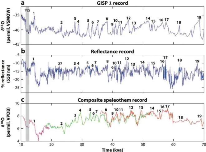
defined in the NH through δ18O analysis of ice cores from the Greenland Ice Sheet (Greenland
Ice Core Project and Greenland Ice Sheet Project 2, GRIP and GISP2, respectively; Langway et al., 1985; Grootes and Stuiver, 1997; Figure 2.6). These abrupt warm events were termed Dansgaard-Oeschger (DO). Cold events, defined by concentration of Ice Rafted Debris (IRD) –rich layers within marine sediment cores from the high latitudes of the North Atlantic were termed Heinrich (Bond et al., 1992).
Later on, Peterson et al. (2000), for instance, showed that the abrupt changes described for the high latitudes of the NH were also recorded in the tropics. They based their conclusions in a 90,000-year sediment record from the anoxic Cariaco Basin off the coast of northern Venezuela (Figure 2.6). Variations in the terrigenous input to Cariaco Basin reflected changes in the hydrological cycle related to the Atlantic ITCZ, which resulted in color reflectance variations. Within dating uncertainty, the Cariaco record matches the abrupt climate change showed in the Greenland ice cores. Another record, δ18O obtained from
13
Greenland δ18O record, showing all major Greenland DOs (Wang et al., 2001). These records
suggested a strong and fast linkage between the high-latitude North Atlantic temperatures with rainfall in the Atlantic ITCZ and Asian monsoon regions.
Heinrich Stadials impacted continental tropical climates mainly through changes in intensity of monsoon systems. In SA, during these events, a significant decrease in North Atlantic SST shifted the ITCZ location southwards, strengthening the SASM (Wang et al., 2004). In the NH, the same southward shift of the ITCZ associated with an expansion of the Siberian extratropical anticyclone reduced the Asian Monsoon intensity (Wang et al., 2001; Wang et al., 2008b).
Figure 2.6: Proxy records spanning from 10 to 70 cal kyr BP that demonstrate the close relationship between Greenland temperatures and rainfall records from the tropical Atlantic and China during the last glacial period. (a) Greenland temperatures during the last glacial period, as recorded by δ18O from the Greenland Ice Sheet Project 2 (GISP2) core (Grootes and Stuiver, 1997). Interstadial (warm) events are numbered. (b) 550-nm reflectance record from a sediment core from the Cariaco Basin (Peterson et al., 2000), resulting from changes to the terrigenous input that reflect continental hydrological changes. (c) Stable oxygen isotope record from speleothem records in Hulu Cave, China (Wang et al. 2001). Different-colored lines indicate the different speleothem records from the same cave. The timing of the Younger Dryas (YD) cold event is shown, banded in gray. Extracted from Chiang et al. (2012).
14
A modeling study by Chiang et al. (2003) highlighted the sensitivity of the Atlantic ITCZ position during the last glacial to changes in both land ice and sea ice extent. Together, modeling efforts are consistent with the hypothesis that AMOC variations, and their effect on heat transport, hemispheric SST patterns, and ITCZ position, can be invoked to explain the strong covariation observed between Greenland and Cariaco Basin proxy records (Hughen et al., 1996; Peterson et al., 2000; Chiang and Friedman, 2012).
In Brazil, the first studies on the impact of millennial abrupt events were (Arz et al., 1998; Arz et al., 1999), based in terrigenous input and planktonic foraminifera 18O off NE
Brazil. They showed increased terrigenous input during Heinrich events due to a southward shift of the ITCZ. Within the continent, series of δ18O from stalagmites confirmed the
antiphase correlation between the intensity of the Asian and South American monsoon systems, demonstrated that stalagmite growth in caves of northeastern Brazil occurred only during wet phases synchronous with Heinrich events (Wang et al., 2004; Wang et al., 2007) and related negative 18O excursions with SAMS intensification in speleothems from caves in
southeastern SA (Cruz et al., 2005a; Cruz et al., 2005b; Cruz et al., 2006; Wang et al., 2007). Other factors controlling regional paleoclimatic changes included latitudinal variations in the AMOC (Wang et al., 2007; Cruz et al., 2009).
2.2.4. The Bølling - Allerød Interstadial/ O interestadial Bølling-Allerød
The historical and widely employed nomenclature for the main climatic events that occurred during Termination I include (from oldest to youngest; Mangerud et al., 1974) the Oldest Dryas (OLD), Bølling, Older Dryas (OD), Allerød, and Younger Dryas (YD). These terms were established in the beginning of the 20th century, primarily describing
biostratigraphic changes, more specifically changes in the content of palynomorphs in sediment layers, in Danish lakes. The alternation between layers containing pollen from
Dryas octopetala, characteristic of tundra, and remains of Bertulaceae family, adjusted to temperate climate, indicated the oscillation between extremely cold and milder climates,
respectively (Iversen, 1954; Anderson, 1997).
In this sense, OLD is chronostratigraphically poorly defined, being usually replaced by
Heinrich Stadial 1 because of the apparent synchronicity (Rasmussen et al., 2014). The term
15
a comparably significant climatic oscillation between Allerød and Bølling warm phases outside of Northern Europe (Gray and Lowe, 1977), in principle justifying the usage of Bølling-Allerød as one continuous warm phase (interstadial). YD is a relative term distinguishing between a younger layer chronostratigraphically dated around 12 cal kyr BP and OD. Among these terms, YD is the most largely used.
The Bølling-Allerød Interstadial (BA), on the other hand, has been consistently described in tree-rings from Germany (Friedrich et al., 2001), marine sediments from Cariaco Basin (Hughen et al., 2000), stalagmites in Asia (e.g., Sinha et al., 2005; Cheng et al., 2013), Mg/Ca in planktonic foraminifera from the western South Atlantic (Chiessi et al., 2008), ice cores from Greenland (e.g., Rasmussen et al., 2014; although in this record BA is referred to as DO-1), and the South American Andes (e.g., Thompson et al., 1998).
The BA is one of the most significant abrupt events of Termination I. One of the reasons relates to the major increase in atmospheric CO2 and CH4 concentrations, around 12
ppmv (parts per million per volume) and 150 ppbv (parts per billion per volume), respectively, within a time interval between 50 and 200 years (Marcott et al., 2014), and a sea-level rise of ~20 m in less than 500 years, namely Melt Water Pulse 1A (MWP1A) (Deschamps et al., 2012).
The mechanisms that explain its occurrence remain unclear, but there have been indications that increased inflow of warm saline waters from the Indian Ocean entered the Atlantic via the Agulhas Leakage around 14.9 cal kyr BP (Chiessi et al., 2008), which may have contributed for the abrupt resumption of the AMOC and consequently for the warming in the NH (McManus et al., 2004). Further on, a study by Thiagarajan et al. (2014) showed evidence that a thermal inversion (warm waters under cold ones) developed in deep North Atlantic around 15 cal kyr BP. This metastable thermal inversion was sustained by differential salinity content and may have stored heat in deep North Atlantic, triggering the rapid AMOC restart at the onset of BA as the built up warmth was released (Thiagarajan et al., 2014). In yet another hypothesis, Koehler et al. (2014) defend that a sudden decrease in atmospheric 14C
around the onset of the BA indicates degassing of an extremely 14C–poor or even 14C–free
16
17
3.
Study area, modern oceanography and climatology
/ Área de
estudo, oceanografia e climatologia modernas
Study area
/ Área de estudo
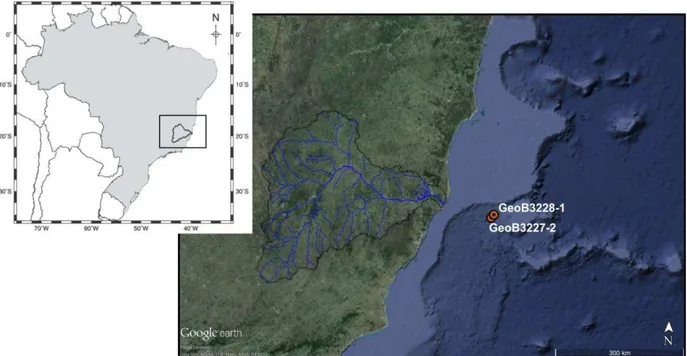
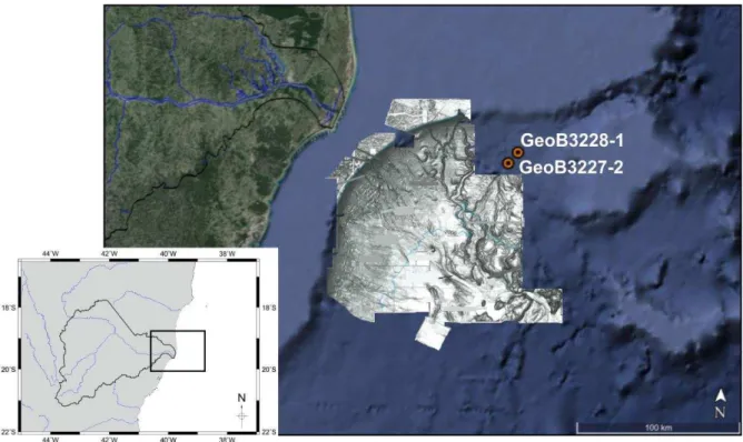
The marine sediment cores selected for this project, GeoB3227-2 and GeoB3228-1 (Pätzold et al., 1996) (see section 4.1), were collected on the eastern Brazilian continental slope at the Espírito Santo Basin, southward of the Abrolhos Bank and Vitória-Trindade Ridge and close to the Doce River Canyon System (Schreiner et al., 2009). Continental slopes present the most unstable sedimentation areas in the oceans, favorable for the development of canyons and submarine incisions that serve as channels for the transport of terrigenous sediments from shallower areas and the continent to the deep ocean by turbidity currents (Heezen et al., 1959).
Eastern Brazil (30°S to 15°S) is characterized by a mountainous landscape, bordered by narrow coastal plains, high rainfall, tropical vegetation, and relatively short coastal rivers, limiting the terrigenous input to the Eastern South American continental margin between La Plata and São Francisco rivers (Summerhayes et al., 1976; de Almeida et al., 1981).
The Doce River Basin (Figure 3.1) is an important medium sized drainage basin in eastern Brazilian coastal zone (Marques et al., 2004; de Oliveira et al., 2012) with area of
86.715 km2 (http://www.cbhdoce.org.br/; Souza and Knoppers, 2003) constituting the second
18
Terrigenous sediments at our marine core sites (Figures 3.1 and 3.2) have been directly delivered by the Doce River (Tintelnot, 1995; Tintelnot et al., 1998) during Late Pleistocene, when the river’s mouth was located beyond the current shelf break, locally between 60 and 70 m water depth (Bastos et al., 2015). Under Pleistocene low sea-level conditions, the likely transport path for terrigenous sediment to the study site was via one of the incised valleys of the Doce River Canyon System (Brush et al., 2004; Schreiner et al., 2009; Maia, 2013; Figure 3.2). Connections between the river and these incised valleys have been previously suggested in the scientific literature (França, 1979; Alves, 1999; Maia, 2013; França et al., 2015). Furthermore, geochemical measurements at the mid-continental slope of the Abrolhos Bank
and the Doce River shelf (Tintelnot, 1995; Massé et al., 1996) registered high kaolinite
contents, connected with the eastern and southeastern Brazilian rivers’ mineralogical
signature, supporting our provenance hypothesis.
19
The river’s mouth forms the largest wave-influenced delta in the Brazilian coast, which progradated continuously through the late Pleistocene, dominated by fluvial processes. The delta formation kept pace with the deglacial rising sea level due to relatively high rainfall in the Doce River drainage basin and high amount of total suspended sediments transported by the river (Rossetti et al., 2015).
20
Modern oceanography of the western South Atlantic adjacent to the
Doce River shelf /
Oceanografia moderna do oeste do Atlântico Sul
adjacente à plataforma do Rio Doce
The outer shelf and upper 600 m of the water column over the continental slope in the study area are occupied by the Brazil Current (BC). Starting around 10oS and flowing
southward, BC is the western boundary current that closes the SSG (Figure 3.3). It originates at the bifurcation of the southern branch of South Equatorial Current, that also feeds the North Brazil Current (NBC; Stramma, 1991; Stramma and England, 1999). The BC starts as a relatively weak western boundary current transporting waters warmer than 20°C and more saline than 36 psu, namely Tropical Surface Water (TSW), increasing its transport volume southwards as the South Atlantic Central Water (SACW) reinforces the southward flow (Emílsson, 1961; Peterson and Stramma, 1991; Stramma and England, 1999; da Silveira et al., 2000). The latter, is located just below the mixed layer (that has its lower limit around 70 m), and is described by a straight line between 20⁰C, 36 psu and 5⁰C, 34.3 psu in T-S diagrams (Figure 3.4; Stramma and England, 1999). Although SACW mainly originates in the SSG, it also receives contribution from the south Indian Ocean by Agulhas Current intrusions (Stramma and England, 1999). Only the upper ca. 100 m of the water column are affected by seasonally varying temperatures and salinities in the western tropical South Atlantic (Peterson and Stramma, 1991).
21
influencing the local sedimentation and primary production (Summerhayes et al., 1976; Ekau and Knoppers, 1996; Knoppers et al., 1999).
Below SACW, at intermediate depths (i.e., 500 to 1500 m), the Intermediate Western Boundary Current transports AAIW and the underlying UCDW equatorwards (Figure 3.4; Tsuchiya and Talley, 1994; Schmid et al., 1995; da Silveira et al., 2004). Compared with AAIW, SACW is warm and salty (Stramma and England, 1999). AAIW is formed in the Subantarctic Frontal Zone (Talley, 1996) from a surface region of the circumpolar layer and its characteristic relative oxygen maximum and salinity minimum were found in the study area at 800m water depth (Tsuchiya and Talley, 1994; Locarnini et al., 2013). Below AAIW, UCDW is defined by its very low oxygen content and can be recognized as an oxygen minimum tongue lying just under the relatively well oxygenated AAIW (Tsuchiya and Talley, Figure 3.3: (Above) Schematic representation of the
22
1994). UCDW’s relative potential temperature minimum and oxygen minimum were found around 1100m.
At greater depths, the western tropical South Atlantic is filled by the southward flowing North Atlantic Deep Water (NADW) between ca. 1500 and 3000 m water depth, and two southern sourced northward flowing water masses, namely Lower Circumpolar Deep Water (LCDW) between ca. 3000 and 3500 m water depth, and Antarctic Bottom Water (AABW) present between ca. 3500 m water depth and the bottom of the ocean (Stramma and England, 1999). While NADW shows relatively high salinities, low nutrient content and high oxygen values, AAIW and UCDW are relatively fresh, show high nutrient content and low oxygen values (Figure 3.4).
Figure 3.4: Properties of the water column in the study area. (a) Location of the interpolated data stations, (b) potential temperature-salinity diagram, (c) oxygen-phosphate diagram. Both panels (b and
c) were plotted based on World Ocean Atlas 2013 data from 18˚S to 23˚S, from the Brazilian coast to
36˚W, and from 0 to 3000m water depth, as shown in the inset map (a). Water masses are labeled by
their acronyms: AAIW – Antarctic Intermediate Water, NADW – North Atlantic Deep Water, SACW
23
Modern climatology of Doce River basin
/
Climatologia moderna da
Bacia do Rio Doce
The Doce River basin is located in a hot and humid tropical climate region with distinct rainy summer and dry fall-winter seasons (i.e., Cwb, Cwa and Aw, Köppen-Geiger climate types; Peel et al., 2007). This seasonality is due to SASM and SACZ activity, fed by moisture
from the ITCZ (see section 2.1.2). The average precipitation in the basin is 1400 mm/a with at least 80% of the rain falling during the rainy season (October to March; Figure 3.5). Exceptionally, in areas close to the coast, rains are distributed throughout the year, with austral winter rainfall brought by extratropical cyclones during the winter (Garreaud et al., 2009). The river discharge is also the second largest of the Brazilian eastern coast and is strongly seasonal, following the rainfall pattern. The river’s runoff averages at 900 m3/s,
varying from 500 m3/s, from May to October, to 1300 m3/s, from November to April
(www2.ana.gov.br; runoff measurements from the Colatina Water Station, located 90 km
from the river mouth). Table 3.1 provides details about the selected locations for which precipitation histograms are shown in Figure 3.5.
ANA code Nearest
city, state
Monitored period
Location within the basin
a 1842004
São Pedro do Suaçui,
MG
1941-2015 north
b 1939002 Linhares, ES 1974-2015 east
c 2043010 Piranga, MG 1941-2005 south
d 1942008 Dom Cavati, MG 1969-2005 center
e 56994500 Colatina, ES 1939-2014 from river mouth 90 km inland Table 3.1. Data from the selected monitoring stations for which histograms are shown in
24
Figure 3.5: Histograms of monthly precipitation at selected stations (panels a, b, c and d) from the
25
4.
Materials and methods
/
Materiais e métodos
Materials
-
Marine sediment cores
/
Materiais
-
Testemunhos sedimentares
marinhos
Gravity cores GeoB3227-2 (19°49’12” S, 38°47’24” W, 1340 mbsl and 564 cm total length) and GeoB3228-1 (19°45’36” S, 38°45’36” W, 1095 mbsl and 567 cm total length) were retrieved from the Brazilian continental slope during RV Victor Hensen cruise JOPS II, leg 8 (Pätzold et al., 1996). The core sites are located 105 km from the modern Brazilian coastline and 110 km of the current mouth of the Doce River, at the Espírito Santo Basin. The gravity cores were stored at 4oC under controlled humidity in the GeoB Core Repository,
MARUM - Center for Marine Environmental Sciences, University of Bremen, Germany.
Methods /
Métodos
4.2.1. Marine sediment cores visual evaluation, sampling and sample processing /
Avaliação visual dos testemunhos de sedimento marinho, amostragem e processamento das amostras
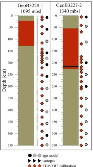
Gravity core GeoB3227-2, 564 cm long, is composed of olive gray clay and mud. Exceptionally, between depths 56 cm and 233 cm the sediment is reddish brown. Gravity core GeoB3228-1 presents similar characteristics to GeoB3227-2. It is constituted mostly of olive gray mud with a reddish brown layer between 66 cm and 150 cm (Figure 4.1).
Marine sediment core GeoB3228-1 was sampled for isotopic analyses every two centimeters (276 samples in total) with 10 ml syringes, labelled, weighted while wet, packed and brought to the Paleoceanography and Paleoclimatology Laboratory (P2L) at the School of
Arts, Sciences and Humanities of the University of São Paulo, Brazil.
The sample’s preparation for benthic foraminifera selection was executed in the P2L,
26
The sample’s preparation for calibration of the element intensities was executed in laboratories from the University of Bremen, Germany. At the MARUM – Center for Marine Environmental Sciences, 24 samples from GeoB3228-1 and 21 samples from GeoB3227-2 were selected and taken with cut syringes to be analyzed via Energy Dispersive X-Ray Fluorescence (EDP-XRF). Samples were spaced 25 cm on average, but a smaller value was chosen for a better representation of core sections that showed distinct features on a Fe/Ca
versus depth plot. The 45 samples were freeze-dried, powdered and homogenized with an agate mortar.
27 4.2.2. AMS radiocarbon dating and age models/ Datações radiocarbônicas AMS e
modelos de idade
Radiocarbon analyses were used to establish accurate age models for the sediment cores selected for this dissertation. With this purpose, one AMS 14C dating was performed
approximately every 50 cm for each marine sediment core.
Three AMS 14C ages obtained at 6, 200 and 300 cm core depths of core GeoB3227-2
were already available (Chiessi et al., unpublished data; Table 5.1, section 5.1). Similarly, seven AMS 14C ages at 8, 58, 108, 158, 208, 258 and 508 cm core depths of core GeoB3228-1
were also available (Chiessi et al., unpublished data; Table 5.1, section 5.1).
For this project, 15 samples were chosen to produce detailed age models for both gravity cores. After sample preparation, 10mg of Globiogerinoides ruber tests (around 600 tests) of each sample were selected for AMS 14C dating from the >125 µm fraction using
25-50X magnification under a binocular microscope. For those cases where not enough G. ruber
specimens were available, the sample was complemented with Globigerinoides sacculifer. When both species were not enough to reach the desired mass, the amount was completed with other planktic species, avoiding deep-dwellers such as Globorotalia truncatulinoides. The 15 samples were then sent for analyses via AMS at BETA Analytic Laboratory, Miami, USA.
The raw radiocarbon ages were calibrated for the reservatory effect (Franke et al., 2008) and for variations on the original 14C concentration in the atmosphere (Reimer et al., 2013).
For this calibration we used software Calib 7.0.2 (Stuiver and Reimer, 1993) and the Marine13 calibration curve (Reimer et al., 2013). Age models were produced based on the linear interpolation of the calibrated ages.
4.2.3. Benthic foraminifera selection strategy/ Estratégia para seleção de foraminíferos
bentônicos
Before starting the systematic picking of benthic foraminifera for 13C and 18O
28
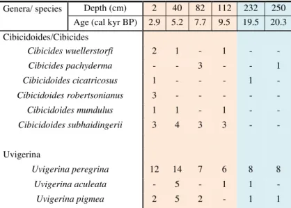
preliminary age model available. The results of this preliminary search are shown in Table 4.1.
Table 4.1 Results of the preliminary selection of benthic foraminifera from core GeoB3228-1,
considering the genera Cibicidoides/Cibicides and Uvigerina (orange and blue background show the
Holocene and Termination I, respectively). Number of specimens per sample.
Genera/ species Depth (cm) 2 40 82 112 232 250 Age (cal kyr BP) 2.9 5.2 7.7 9.5 19.5 20.3 Cibicidoides/Cibicides
Cibicides wuellerstorfi 2 1 - 1 - -
Cibicides pachyderma - - 3 - - 1
Cibicidoides cicatricosus 1 - - - 1 -
Cibicidoides robertsonianus 3 - - - - -
Cibicidoides mundulus 1 1 - 1 - -
Cibicidoides subhaidingerii 3 4 3 3 - -
Uvigerina
Uvigerina peregrina 12 14 7 6 8 8
Uvigerina aculeata - 5 - 1 1 -
Uvigerina pigmea 2 5 2 - 1 1
The only consistently found species was Uvigerina peregrina (Cushman, 1923) and no single Cibicidoides or Cibicides species was present on all samples. From these latter genera, the following species were found (from the more abundant to the less abundant): Cibicidoides subhaidingerii (Parr, 1950), Cibicides pachyderma (Rzehak, 1886) and Cibicides wuellerstorfi (Schwager, 1866). Thus, U. peregrina and Cibicidoides spp. (a mixture among
Cibicides and/or Cibicidoides specimes present at each sample) specimens were picked separately.
Microfossil slides were used to store three to eight tests of U. peregrina or Cibicidoides spp.. Each test was over 0.3 mm and picked from the >125µm fraction using 25-50X magnification under a binocular microscope. On eventual samples where the Cibicidoides
and/or Cibicides genera were abundant, three to five tests of individual species were picked. This aimed to perform a comparison between Cibicidoides spp. isotopic values and species specific isotopic offsets available in the scientific literature (e.g., Fontanier et al., 2006).
29 4.2.4. δ18O and δ13C of benthic foraminifera / δ18O e δ13C de foraminíferos bentônicos
Oxygen and carbon stable isotopes are traditional paleooceanographic proxies used for reconstituting physical and chemical characteristics of water masses and ocean circulation. 18O in marine carbonates is presently widely applied for assessing past variability in ocean
circulation (e.g., Lynch-Stieglitz et al., 2006), continental ice volume (e.g., Waelbroeck et al., 2002), ocean water salinity (e.g., Adkins et al., 2002; Weldeab et al., 2006) and, paired with Mg/Ca, temperature (e.g., Emiliani, 1955; Waelbroeck et al., 2002). 13C of foraminiferal
calcite provide a wealth of information on the carbon cycling of the oceans, and has been used to infer the distribution of deep water masses and their geographic and bathymetric distributions (e.g., Curry and Oppo, 2005), but also for variations of biological productivity and variations in the global carbon cycle (e.g., Duplessy et al., 1988).
Isotopic ratios of stable isotopes are a measurement of fractionation processes. The isotopic composition of a sample is expressed using the notation (i.e., 18O and 13C), which
represents the difference between the ratio of the least over the most abundant isotope of a sample and an internationally recognized standard, expressed in parts per thousand (i.e., ‰).
Equation 1 exemplifies the calculation of 18O.
Equation 1:
�18�
� � = [
( �18 ⁄16�) � � − ( �18 ⁄16�) � �
( �18 ⁄16�) � � ] � 3
, which can be written as:
�18�
� � = [
( �18 ⁄16�) � � ( �18 ⁄16�)
� �
− ] � 3
For carbonate isotopic ratios the most used standard is Vienna Pee Dee Belemnite (VPDB), normalized in relationship to the chemical composition of Belemnitella americana
30
The oxygen isotopic composition in marine carbonates varies both with temperature and the isotopic composition of seawater, which is in turn dependent on the global ice volume and
correlated with local salinity (Waelbroeck et al., 2002; Mulitza et al., 2003). Surface 18O w is
generally positively correlated to salinity because both parameters are largely controlled by evaporation and precipitation (Craig and Gordon, 1965). Although the relationship between salinity, temperature and foraminiferal 18O is relatively well understood, the latter cannot be
used as a directly proportionate proxy for either temperature or salinity because both affect 18O in opposite directions and, therefore, tend to cancel each other out (Curry and Oppo,
2005). Still, the equilibrium calcite 18O values of water masses originating in the South
Atlantic is generally higher at every water depth and denser than water masses originating in the North Atlantic because the difference in temperature dominates the equilibrium 18O
values (Curry and Oppo, 2005). 18O in benthic foraminifera is a valuable deep water tracer,
which values reflect conservative sea water properties and, assuming negligible geothermal and pressure heating effects, can only change due to mixing between water masses (e.g., Oppo et al., 2015).
A wide variety of factors affect seawater carbon composition (e.g., biological productivity and global carbon cycle) and its isotopic incorporation in foraminiferal calcite
(e.g., species specific vital effects). Despite of that, 13C is a useful proxy as water mass tracer
because it is characteristic of its formation and can only be altered by mixing with water
masses of another 13C composition, by the oxidation of low-δ13C organic matter or ‘‘aging’’
(Curry and Lohmann, 1982; Kroopnick, 1985; Curry and Oppo, 2005).
Foraminifera use marine total dissolved inorganic carbon (DIC) to precipitate their calcite tests, recording 13C of seawater. DIC comprises the sum of the concentrations of CO
2
(aqueous carbon dioxide), HCO3- (bicarbonate), and CO
32- (carbonate ion), and seawater pH
controls the relative proportion of the different components (Kroopnick, 1985). Biological primary production in the euphotic zone, when producers take up nutrients and carbon (photosynthesis), strongly fractionates stable carbon isotopes concentrating the light isotope
12C in organic matter, and enriching superficial water in 13C (Freeman and Hayes, 1992), as
recorded by shallow dwelling planktonic foraminifera. Deeper in the water column, the 12
C-rich organic matter is oxidized and remineralized, adding nutrients, and carbon with low