www.hydrol-earth-syst-sci.net/16/2469/2012/ doi:10.5194/hess-16-2469-2012
© Author(s) 2012. CC Attribution 3.0 License.
Earth System
Sciences
Assessing ecological land use and water demand of river systems:
a case study in Luanhe River, North China
D. H. Yan1,2, G. Wang1,2, H. Wang1,2, and T. L. Qin1,2,3
1State Key Laboratory of Simulation and Regulation of Water Cycle in River Basin, China Institute of Water Resources and
Hydropower Research, Beijing, 100038, China
2Water Resources Department, China Institute of Water Resources and Hydropower Research, Beijing, 100038, China 3Environmental Science and Engineering Department, Donghua University, Shanghai, 201620, China
Correspondence to:G. Wang ([email protected])
Received: 16 August 2011 – Published in Hydrol. Earth Syst. Sci. Discuss.: 17 October 2011 Revised: 7 July 2012 – Accepted: 10 July 2012 – Published: 6 August 2012
Abstract.Economic and social development has greatly in-creased ecological water demand and modified land use of river systems worldwide, causing overall degradation of many of these systems. In this study, theoretical and techni-cal frameworks for regionalization on the eco-environmental function of river systems are formulated and applied to the Luanhe River system. Based on its eco-environmental func-tions, this river can be regionalized into four types of first-class functional areas: ecological preservation areas, habi-tat restoration areas, ecological buffer areas and develop-ment and utilization areas. Considering the overall eco-environmental functions, we assessed the ecological land use of the Luanhe River system. The total area of basic ecological land use is 876.98 km2; the restrictive ecological land use is 1745.52 km2; ecological land use of the river system returned from farmland is 284.25 km2; and that returned from con-struction land is 17.35 km2. The average minimum ecologi-cal flow of mainstreams in upper and middle reaches of the Luanhe River is 4.896 m3s−1 based on the habitat method. And the recommended minimum and suitable annual eco-logical water demand of channels in the lower reaches are 391 million m3and 819.5 million m3, respectively. The evap-oration and seepage consumption and vegetation consump-tion in riparian zones of the Luanhe River system are ap-proximately 132.6 million m3and 145.3 million m3per year, respectively. Our results suggest that is crucial to regulate the instream ecological water use of the Luanhe River’s mainstream starting from the Panjiakou-Daheiting Reser-voir system. We recommend accelerating ecological land-use
planning and strengthening the regulation of ecological water use on this river system focusing on important lower reaches under the condition of competitive water demand.
1 Introduction
et al., 1997), is also seriously occupied. Consequently, the river system degrades under severe interference (Jones et al., 2010).
The earliest research on water demand of river ecologi-cal environment went back to the concern of US Fish and Wildlife Service (USFWS) about instream flow in the 1940s (Ward and Stanford, 1979). Between 1960s and 1970s, many scholars had discussed the methods for determining the min-imum ecological instream flow, which were applied to the assessment and planning of some famous rivers (Loar and Sale, 1981). Between 1980s and 1990s, more sophisticated theoretical and methodological systems for the calculation of instream flow have been proposed (Bovee, 1986; Petts, 1996; Poff et al., 1997; Lytle and Poff, 2004; Henry and Amoros, 1995; Henry et al., 1995; Geoffrey, 1996; Hughes, 2001). Since 1980s, the restoration of degraded riparian ecosystems and the management of riparian buffer zones have received lots of concerns from regulatory agencies worldwide. A large number of experiments and research focusing on water re-source protection, soil and water conservation and other ba-sic eco-environmental functions of riparian buffer zones have been conducted (Lowrance et al., 1985; Knopf et al., 1988; Phillips, 1989; Sweeney et al., 2004; Schoonover et al., 2005; Baker et al., 2006; Lees and Peres, 2008; Lennox et al., 2011). Consequently, a number of new regulations regarding riparian management were created (Morrison, 1988; Welsch, 1991; Smith and Hellmund, 1993). Currently, the majority of resource development and eco-environmental protection re-search focus on microcosmic processes disregarding macro-scopic aspects. Assessment on single functions (resource function or environmental function) is more frequently car-ried out than on multiple functions. Therefore, it is urgent to perform integrated management of river systems to maintain water and eco-environmental safety, so as to fully play the multi-attribute functions of the systems.
As one of the four first-class basins in Haihe River Basin, North China, Luanhe River Basin is not only an important mineral resource distribution area, but also one of the im-portant water sources of Bohai Rim economic circle. With increasing economic and social development, the ecolog-ical land use and water use of the Luanhe River system have been seriously modified, which causes overall degra-dation of the river system and threatens the entire ecological and water safety of the basin. The objective of this study is to formulate suggestions for government policy makers in planning regional eco-hydrological regulation of the Luanhe River Basin. We take the Luanhe River as an example for our study in which we (1) assessed the ecological water de-mand of the river system, (2) presented and argued the the-oretical and technical frameworks of regionalization on eco-environmental function of the river system, (3) regionalized the Luanhe River with systemic identification of crucial eco-environmental functional areas in the basin, and (4) evalu-ated the ecological land use in the Luanhe River system. We calculated the ecological instream flow including prototype
observation experiments. This calculation was made using the habitat method, which is based on the theoretical frame-work of IFIM (instream flow incremental methodology). In this study, aquatic macroinvertebrates were taken as target species for instream flow evaluation, assuming that these species play an important role in sustaining the integrity of the aquatic ecosystem. Statistical methods are used in con-junction with GIS techniques and approaches in the ecologi-cal land-use assessment.
2 Site description
Located between 115◦34′E–119◦50′E and 39◦02′N– 42◦43′N in the northeast of North China Plain, the Luanhe
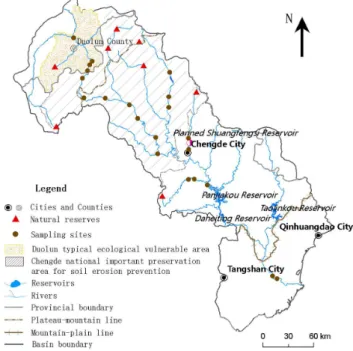
River Basin covers a total area of 44 700 km2 with an average width of 103 km. Originating from the north foot of the Bayanguer Mountain in Zhangjiakou, Hebei Province, the river travels through 27 cities and counties of Hebei Province, Inner Mongolia autonomous region and Liaoning Province and finally flows into the Bohai Bay. The basin is inclined from northwest to southeast. The upper basin consists of Bashang and paddock plateau regions with undu-lating terrain and lots of wind deflation hollows. The middle basin consists of North Hebei and Yanshan Mountain hilly areas with very deep river valleys. The lower basin consists of Yanshan Mountain front plain and Luanhe delta plain, which are intensively influenced by human interference. The Luanhe River Basin shows diverse geomorphic types, of which mountains, hills and basins cover about 70 % of the total basin area. Plateaus and plains account for about 16 % and 12 %, respectively. In addition, river valleys, beaches, terrace and tableland are also broadly distributed in this area, where typical temperate continental climate prevails as hot and rainy in summer and cold and dry in winter. The mean annual temperature is 7.6◦C and the mean annual rainfall is 520 mm with the rainy season from July to September. The river system is well developed in this basin, where nine first-class branch rivers exist with the catchment area more than 1000 km2. The location of the study area is shown in Fig. 1.
Fig. 1.Location of the study area.
is occupied by the unreasonable development and utilization of land resources in riparian zones, exacerbating the contra-diction of the land struggle between human and water. With global climate change, the runoff of the Luanhe River system is dramatically decreased and the mean annual surface water resource during the period 2000–2009 is only 40.6 % of that between 1956 and 2000 according to the long-term observa-tion data from gauging staobserva-tions. In addiobserva-tion, emerging with the rapid development of economy, water quality problem causes the contradiction of water supply and demand even harsher.
3 Materials and methods
3.1 Materials
3.1.1 Sampling
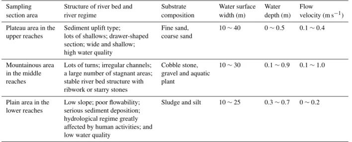
Sampling of benthic invertebrates in the Luanhe River Basin was completed in July and October of 2010. Samples were collected in a series of sites from upper plateau reaches, mid-dle mountainous reaches and lower plain reaches during dif-ferent months under various flow conditions (21 sites in total, with a minimum of three samples per location). The loca-tions of sampling sites in the Luanhe River Basin are shown in Fig. 2.
Firstly, study sections were divided into several areas ac-cording to habitat types of shallow, deep stream and deep pool for sample collection. The collection tools include a 30 cm×30 cm Surber sampler and a 15 cm×30 cm grab
Fig. 2.Sampling sites and crucial eco-environmental functional ar-eas in the Luanhe River Basin.
bucket-type sediment collector with primary collection ar-eas of 0.09 m2and 0.045 m2, respectively. The Surber sam-pler was applied to mountainous areas of the Luanhe River, where the substrate compositions of river beds are cobble or gravel with a water depth no more than 0.5 m. Equipped with a 200 µm stainless steel sieve, the grab bucket-type sedi-ment collector had obvious advantages when applied to lower reaches with poor flowability and sand substrate in plain ar-eas of the Luanhe River. The samples were fixed with 4 % formaldehyde. Meanwhile, we recorded the measurements of water depth, mean water column velocity, water surface width and substrate characteristics of each sampling place. Moreover, the position of each sampling site was determined with GPS.
In the entire investigation, a total of 49 kinds of benthic animals were collected, belonging to 12 orders (classes) and 30 families. Among them, 36 kinds are aquatic insects, be-longing to 7 orders and 21 families, accounting for 73.5 % of the total. Five kinds are mollusks, belonging to 4 families and accounting for 10.2 %. Four kinds of oligochaeta belong to 2 families, accounting for 8.2 %. The remaining four kinds be-long to 3 families, accounting for 8.2 %. Benthic animal com-munities, belonging to Chironomidae (Diptera), were identi-fied at all sampling places with higher species abundance and dominance.
and other properties of river banks, and the composition and distribution of instream biological groups. The descriptions of eco-environmental characteristics of sampling sites in dif-ferent areas are listed in Table 1.
3.1.2 Crucial eco-environmental functional areas
Crucial eco-environmental functional areas mean those areas that have important ecological service function and play an important role in providing goods and services, safeguarding ecological integrity and biological diversity, and maintain-ing regional eco-environmental safety (Arcese and Sinclair, 1997; Marulli and Mallarach, 2005; Yu et al., 2004). At the same time, they are generally of high ecological sensibility and vulnerability (Long, 2001), and special attention should be given in the ecological land use planning and water man-agement activities. The crucial eco-environmental functional areas in the Luanhe River Basin are shown in Fig. 2.
Crucial natural preservation areas
Lots of national and provincial natural reserves are dis-tributed along the headstreams of some important branch rivers in the mountainous areas of the upper and middle reaches of the Luanhe River Basin. With an outstanding func-tion of water source conservafunc-tion, a large area of complete typical forest or prairie ecosystem is reserved in these preser-vation areas. Moreover, natural preserpreser-vation areas possess abundant biological resources and gene pool resources with distinct and unique biological diversity. In addition, close to Beijing and Tianjin, these natural reserves play an impor-tant role in the protection of ecological safety of the Beijing-Tianjin area.
Chengde important national soil erosion preservation areas
The Luanhe River Basin in Chengde district is one of the 16 national important preservation areas in China approved by the State Council in 2006 for soil erosion prevention. The to-tal area is 23 000 km2, accounting for 80 % of the catchment above the Panjiakou Reservoir, and this area is an important water source of the reservoir. Statistics showed that, during the period from 1990 to 2000, mean annual sedimentation of Panjiakou Reservoir was 12.61 million m3, triple over the period from 1980 to 1989 (Wang and Song, 2007). By the end of 2000, accumulated sedimentation of the reservoir was 180 million m3, accounting for 6.9 % of the modified reser-voir capacity. Although the protection of forests and vegeta-tion has been strengthened in this area and the area of forest-land and grassforest-land has been greatly increased in recent years, the existing secondary forest still has poor soil and water re-taining capacity and the ecosystems of forestland and grass-land are vulnerable on the whole.
Duolun typical ecological vulnerable area in the upper Luanhe River Basin
The vulnerable area is located in Duolun County, Inner Mon-golia autonomous region, where lots of low hills and sand dunes exist. Natural secondary forest, sand meadow and nat-ural wetlands are sporadically scattered among sand belts. In this area, the annual rainfall is only about 380 mm and av-erage wind velocity is 3.0–3.5 m s−1. As a transitional agro-pasture area, Duolun County has a vulnerable ecological en-vironment with serious soil erosion problems. The soil ero-sion area reaches up to 3283 km2, accounting for 87 % of the total, and a large quantity of sediment flows into the lower reaches of the Luanhe River every year. The aggravation of soil erosion and sandstorms not only plagues this county, but also threatens the environmental quality of the capital Beijing and the drinking water quality in Tianjin district.
Water sources of major water supply and transfer projects
Panjiakou Reservoir and Daheiting Reservoir exist as the water sources of water diversion projects from the Luanhe River to Tangshan and Tianjin cities. Taolinkou Reservoir is the water source of the Qing-Qin water transfer project, and Chengde Shuangfengsi Reservoir has been approved in this basin. With rapid economic development in upper reaches of the reservoir, total discharged industrial wastewater and ur-ban domestic sewage have continuously increased in recent years, and the agricultural non-point source pollution has exacerbated by soil erosion. Moreover, water quality of the reservoirs has gradually degenerated with the development of mining industry around reservoirs in the upper reaches.
3.2 Methods
3.2.1 Assessing ecological instream flow demand
Among the body of techniques used to evaluate minimum flows, habitat method based on biological principles is re-garded as a more reliable quantifying method at present. The method is principally based on the theoretical frame-work of instream flow incremental methodology (Midcon-tinent Ecological Science Center, 2001). In this study, the habitat method-WUW (Weighted Usable Width Method) is used to determine the minimum ecological instream flow.
Table 1.Descriptions on eco-environmental characteristics of sampling sites in different areas.
Sampling Structure of river bed and Substrate Water surface Water Flow
section area river regime composition width (m) depth (m) velocity (m s−1) Plateau area in the Sediment uplift type; Fine sand, 10∼40 0∼0.5 0.1∼0.4 upper reaches lots of shallows; drawer-shaped coarse sand
section; wide and shallow; high water quality
Mountainous area Lots of turns; irregular channels; Cobble stone, 10∼30 0.1∼0.9 0.1∼1.0 in the middle a large number of stagnant areas; gravel and aquatic
reaches stable river bed structure with plant ribwork or starry stones
Plain area in the Low slope; poor flowability; Sludge and silt 10∼25 0.3∼0.7 0∼0.2 lower reaches serious sediment deposition;
hydrological regime greatly affected by human activities; and low water quality
histograms can be plotted as the mean number of individuals of per substrate category and normalized to one, as described by Bovee (1986). Then, according to suitability curves, suit-ability indicesf (V )andf (D)of each sampling sites are de-termined, which range from 0 to 1.0, indicating the surviving probability of target species under the corresponding habi-tat condition. For each habihabi-tat parameter, 0 indicates that the condition of the current habitat is completely not suitable for target species and 1.0 indicates the greatest suitability. Be-sides considering the influence of water quality on benthic animal, water quality suitability indexf (Q)was defined as 1.0, 0.6 and 0.3, indicating clean, polluted intermediately and polluted seriously, respectively (Duan et al., 2011). Finally, the habitat suitability width of each section and each target species (i.e., WUW) was calculated with Eq. (1) (Karim et al., 1995):
WUW=XF[f (Vi), f (Di), f (Ci), f (Qi)] ×Wi (1) whereWi is the section width ofi-th area in the study sec-tion; f (Vi),f (Di),f (Ci)and f (Qi) are the correspond-ing suitability indices of flow velocity, water depth, substrate composition and water quality, respectively; andF[ ] is the combined habitat suitability factor, expressed as CSF, calcu-lated with geometric mean method (Layher and Maughan, 1985):
CSF=(f (Vi)×f (Di)×f (Ci)×f (Qi))1/4. (2) Through establishing the relation curve between WUW and flowQ, the minimum flow can be finally obtained ac-cording to the determination of the breakpoint in the curve.
In all benthic animal communities, Diptera (especially Chironomidae), with the highest faunal diversity, were iden-tified as the dominant species in sampling. Therefore, as tar-get species, Chironomidae were used for constructing the habitat suitability model of benthic animals.
3.2.2 Assessing evaporation and seepage of the river system
In the surface evaporation of river water, evaporation depth of water body per unit area indicates evaporation capability. The following is the calculation equation on the net water demand of river evaporation consumption:
Ww=(Ew−P )×H×L (3) whereWw is the net annual water demand (m3)of surface evaporation consumption;Ew is the actual annual evapora-tion capability (mm);P is the average annual rainfall (mm) of a channel;His the average water surface width (m);Lis the river length (km).
Since the water surface width of a river greatly changes with runoff within a year, water surface width in a normal flow period was used as the average width to calculate sur-face evaporation. The data of evaporation capacity and rain-fall can be obtained from adjacent meteorological stations.
Water demand of channel seepage consumption can be cal-culated with the groundwater dynamic method and hydrolog-ical analysis method. However, it is difficult to obtain hydro-geological parameters related to these two methods in real calculation, and thus the water demand of seepage consump-tion was calculated roughly by multiplying the basic instream flow demand by a certain seepage rate. In reference to rele-vant research, the seepage rate of 0.15 was used for rough estimation (Wei et al., 2004).
3.2.3 Assessing water demand of vegetation in riparian zones
Water demand of vegetation in riparian zones can be simpli-fied into water demands of forest land and grassland, calcu-lated with the following equation:
whereWpis water demand of vegetation;Epis annual evap-oration capacity of vegetation (mm); Ap is the vegetation area in a riparian zone.
The physiological mechanism of water consumption by vegetation is very complicated, influenced by many fac-tors, such as climate condition, vegetation condition and soil moisture condition. For convenience, the vegetation in ripar-ian zone was classified into different vegetation types accord-ing to a general land utilization classification system and the value ofEp for each vegetation type was obtained based on the relevant research results of the Haihe River Basin (Li et al., 2002). The coverage area of each vegetation type can be obtained from the land-use data from 2005.
3.2.4 Eco-environmental functional regionalization of river systems
Connotation of functional regionalization
River functional regionalization refers to a river regionalized into functional areas with different utilization types and dif-ferent environmental quality requirements, according to lo-cation condition, resource condition, development and pro-tection situations of various river reaches and regional re-quirements of economic and social development (Xu et al., 2009). Based on the definite functional properties of different reaches, corresponding control indices and limitation condi-tions are proposed for reasonably controlling and correctly guiding the utilization of rivers, so as to achieve the multi-dimensional purposes of environment improvement, land-scape creation, ecological protection and sustainable utiliza-tion. Thereby, the contradiction between natural ecological functions and eco-social functions is well coordinated. Principles of functional regionalization
The functional regionalization should be carried out on the basis of some guiding principles, which are of great im-portance for the integrity, reasonability and operability of regionalization results. These principles include respecting the natural attributes of rivers, meeting the habitat continuity among various functional areas, considering both the natu-ral and social functions of rivers, giving prior to predominant functions and so on (Xu et al., 2009; Wu et al., 2011). The regionalization results should be consistent with water func-tional regionalization, which is particularly convenient for better protection and management of each functional zone. In addition, the regionalization should also be in line with the local socio-economic conditions to satisfy the reasonable water demands for economic development.
Functional regionalization system
There are lots of natural preservation areas in the upper reaches of the Luanhe River system with remarkable func-tions of water source conservation, protection of ecological
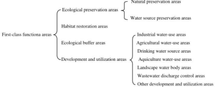
integrity and biological diversity. Moreover, Luanhe River Basin is one of the areas with rapid economic development in North China, where many cities are built in river valleys with urbanization process accompanied by huge demands for wa-ter resources. Therefore, it is necessary to regionalize rivers into ecological preservation areas and development and uti-lization areas, in order to protect the natural integrity of river functions as well as meet reasonable water requirements of human activities. Aiming at grassland shrinkage and soil ero-sion in the upper and middle reaches, ecological function degradation in the plain channels of the lower reaches and other serious issues, ecological restoration and even recon-struction are required in some crucial reaches. Therefore, it is necessary to plan certain ecological restoration areas. Be-sides considering that administrative divisions enable rivers and reaches to be attached to different management entities, buffer areas or transitional areas should be established to en-sure the functional integrality of the river corridor systems, so as to coordinate water demand contradiction among different management entities. Moreover, buffer areas should also be established among different functional areas. Thus, the first-class eco-environmental functional regionalization system is required to include four types of areas: ecological preserva-tion areas, habitat restorapreserva-tion areas, ecological buffer areas and development and utilization areas.
According to different water demand entities, develop-ment and utilization areas are further divided into second-class functional areas, such as industrial water-use areas, agricultural water-use areas, drinking water source areas, aquiculture water-use areas, landscape water body areas and wastewater discharge control areas. With different protection objects, preservation areas can be further divided into natural preservation areas and water source preservation areas. The river eco-environmental functional regionalization system is shown in Fig. 3.
The following are the explanations on first-class eco-environmental functional areas:
a. Ecological preservation areas
Similar to the connotation of preservation areas in water functional areas1, ecological preservation areas refer to the areas crucial for water resource preservation, protec-tion of natural eco-environment and rare or endangered species, in which all development activities are forbid-den. The ecological preservation areas include headwa-ter preservation areas, waheadwa-ter source areas of national and provincial natural reserves or natural ecology sys-tems with typical ecological protection value, and water source areas of large-scale trans-basin, trans-provincial and in-provincial water transfer projects.
1The Ministry of Water Resources of the People’s Republic of
Natural preservation areas Ecological preservation areas
Water source preservation areas Habitat restoration areas
First-class functiona areas Industrial water-use areas Ecological buffer areas Agricultural water-use areas Drinking water source areas Development and utilization areas Aquiculture water-use areas Landscape water body areas Wastewater discharge control areas Other development and utilization areas
Fig. 3. Eco-environmental functional regionalization system of Lu-anhe River.
b. Habitat restoration areas
Habitat restoration areas refer to the areas where river ecosystems have been damaged to some extent by hu-man interference, which can be restored to meet the requirements of continuity and functional integrity of stream habitats under the support of eco-social con-ditions and hydro-geographic concon-ditions. During eco-logical restoration process, it is essential to exert hu-man subjective initiative to restore existing damaged ecosystems, so as to improve and restore partial struc-tures and functions of ecosystems and realize their self-maintenance capabilities.
c. Ecological buffer areas
Ecological buffer areas are used for coordinating wa-ter demand issues among provinces and the areas with serious contradiction, in order to satisfy water require-ments of various entities. When ecological preservation areas and habitat restoration areas are connected with development and utilization areas, ecological buffer ar-eas can keep external influence away from ecological preservation areas, and connect broken habitats to real-ize structural integrity and functional continuity of river systems, thereby achieving the purposes of ecological buffering and social buffering.
d. Development and utilization areas
Same as the connotation of development and utiliza-tion areas in water funcutiliza-tional areas, development and utilization areas mainly refer to the water areas able to meet the water demands of various sectors. These ar-eas mainly consist of important urban reaches within the basin and the areas with extensive water intakes and large water demand on certain agricultural irrigation or fishery production.
3.2.5 Assessment on ecological land use of Luanhe River
The crucial issue for river ecological land-use assessment is to determine the scale and pattern of ecological land use. The
desirable scale of ecological land use should be differenti-ated based on different eco-environmental functions in vari-ous reaches of this basin so as to ensure scientific and practi-cable regionalization results.
Ecological land use of ecological preservation areas
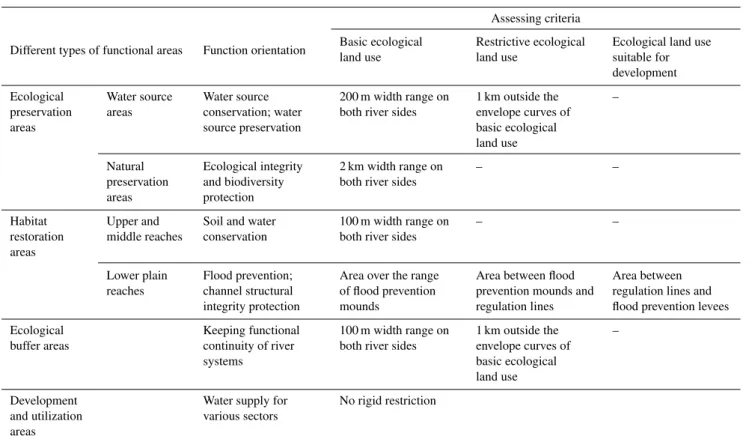
The river reaches with functions of water source conserva-tion and drinking water source preservaconserva-tion are mostly lo-cated in the upper reaches of mountainous areas with a small population and low river development and utilization degree, where ecological land use can be determined with the method of planning buffer areas. In reference to surface water re-source protection plan and regionalization results of urban centralized drinking water source in Hebei Province, the ar-eas within 200 m on both river sides were designated as basic ecological land use. Strict protection measurements should be taken to forbid any form of development activities. The areas 1 km outside the envelope curves of basic ecological land use were designated as restrictive ecological land use, in which development activities could not affect the eco-environmental functions of buffer zones. An increasing area of ecological land use is required for reaches crossing over natural preservation areas to protect the integrity and conti-nuity of habitats. The areas within 2 km on both river sides were designated as ecological land use in this study, and any form of developmental activities should be forbidden. Ecological land use of habitat restoration areas
a. In the upper and middle reaches
The habitat restoration areas in the upper and middle reaches of the Luanhe River are mainly composed of two parts. One is the Duolun typical ecological vulnera-ble area, located in a transitional agro-pasture area with serious desertification and grassland degradation issues. The other is the Chengde important national soil ero-sion preservation areas with vulnerable forest and grass-land ecosystems. Therefore, the riparian buffer zones with effective width are essential for controlling soil erosion. Research conducted by Copper et al. (1987) and Lowrance et al. (1988) showed that 80–100 m ri-parian buffer zones could effectively reduce 50–70 % of sediments. Therefore, 100 m buffer areas on both river sides were designated as ecological land use in the habi-tat restoration areas.
b. In the lower plain reaches
conservancy projects has greatly reduced the instream flow, riparian zone with serious desertification problem accounts for 30.4 % of embankment areas. Moreover, buildings and structures illegally established in channels are seriously affecting the flood discharge. The width of levees on both sides of the Luanhe River ranges from 2.5 km to 5.5 km, while flood prevention mounds, spur dikes and other control and regulation works have been built within the levees. According to the flood control plan of the Luanhe River Basin, the flood control stan-dard of mainstream is designed for resisting flood with a 50-yr reappearance period. Flood prevention mounds belong to beach flood discharge areas with short-term and long-term planning standards for resisting floods with 5-yr and 10-yr reappearance periods, respectively. According to the planning scheme of flood control and regulation approved by Department of Water Resources of Hebei Province, a regulation line with a total length of 75 km has been planned between Luanhe Jingshan railway bridge and the river estuary in the Luanhe River embankment area.
Complying with the principles of respecting actual situ-ations and taking the priority of flood control, ecological land use was assessed within the embankment area, with the regulation line and the flood prevention mounds as boundaries, respectively. The area within flood preven-tion mounds was defined as the protecpreven-tion area of ba-sic ecological land use, where enforced protection mea-sures should be taken to forbid any form of develop-ment and occupation, so as to protect natural ecologi-cal landscape. Moreover, artificial flood pulses should be made effectively in high flow years to flood beach areas periodically, so as to gradually restore the basic eco-environmental functions of damaged channels. The area between flood prevention mounds and regulation lines was designated as restrictive development ecolog-ical land use. Appropriate agricultural activities are al-lowed in this area on the premise of no damage to flood discharge. The area between regulation lines and flood prevention levees was designated as ecological land use suitable for development, and people are encouraged to plant trees and undergo other activities to effectively manage and protect the flood prevention levees.
Ecological land use of ecological buffer areas
The functions of ecological buffer areas were defined be-tween development and utilization areas and ecological preservation areas. It can be simply realized by designat-ing certain buffer areas. The areas within 100 m on both river sides and areas 1 km outside the envelope curves were planned to be basic and restrictive ecological land use, re-spectively.
Ecological land use of development and utilization areas
Most of the development and utilization areas are located in cities, towns and other areas with high population den-sity. The construction land use in riparian zones has formed in a certain scale and pattern; for example, the construction land in Chengde reach of the mainstream of Wuliehe River, a tributary of Luanhe River, accounts for 61 % of the 100-yr floodplain area. And a certain land should be reserved and planned for future urban development. Therefore, the ap-proach of designating a buffer area cannot be used for eco-logical land use assessment. Though the ecoeco-logical land use of these areas is not rigidly restricted in our study, we suggest more emphasis on the protection of existing ecological land use and the regulation of ecological land use pattern.
The assessment criteria for different types of areas are gen-eralized in Table 2.
4 Results
4.1 Ecological water demand of the Luanhe River system
4.1.1 Minimum ecological instream water demand
The suitability curves and substrate histograms are shown in Fig. 4. The flow velocity of the Luanhe River was measured between 0 and 0.97 m s−1. The suitability curve of flow ve-locity shows that the flow veve-locity suitable for Chironomidae is between 0.2–0.5 m s−1, and the most suitable flow velocity
is about 0.3 m s−1. Some types of Chironomidae can also live
in still water. When the flow velocity is higher than 0.6 m s−1,
the suitability index declines greatly. When the flow velocity is higher than 1 m s−1, the species of Chironomidae, unre-sisting to water flow, have more difficulties surviving.
The water depths at sampling sites of the Luanhe River ranged from 0.03 m to 1.05 m. The water depth suitable for Chironomidae is almost between 0.2 m and 0.4 m, and the most suitable water depth is about 0.3 m. Although some types of Chironomidae were identified in water areas above 0.7 m, the diversity of species declined significantly.
Table 2.Summary of criteria of ecological land-use assessment for different types of functional areas.
Different types of functional areas Function orientation
Assessing criteria
Basic ecological land use
Restrictive ecological land use
Ecological land use suitable for development
Ecological preservation areas
Water source areas
Water source conservation; water source preservation
200 m width range on both river sides
1 km outside the envelope curves of basic ecological land use
–
Natural preservation areas
Ecological integrity and biodiversity protection
2 km width range on both river sides
– –
Habitat restoration areas
Upper and middle reaches
Soil and water conservation
100 m width range on both river sides
– –
Lower plain reaches
Flood prevention; channel structural integrity protection
Area over the range of flood prevention mounds
Area between flood prevention mounds and regulation lines
Area between regulation lines and flood prevention levees
Ecological buffer areas
Keeping functional continuity of river systems
100 m width range on both river sides
1 km outside the envelope curves of basic ecological land use
–
Development and utilization areas
Water supply for various sectors
No rigid restriction
slightly, and the river bed substrate with submerged plant shows the lowest biodiversity.
The relationship between WUW of study sites and flow amount is shown in Fig. 5. Currently, slope and curvature methods are usually used for determining the critical mini-mum discharge, i.e., a breakpoint defined at the point of a specific slope (critical value 1 is taken generally) or the maxi-mum curvature on WUW-Qrelation curve (Gippel and Stew-ardson, 1998; Shang, 2008). This breakpoint represents a critical discharge below which habitat conditions for aquatic organisms (usually fish or macroinvertebrates) rapidly be-come unfavorable. The breakpoint in the relationship was calculated using the slope method. The threshold flow of 4.896 m3s−1 was obtained according to the fitting loga-rithmic function WUW = 4.896×ln(Q)+11.04 (p <0.001, R2=0.831). For comparison, we also calculated the average minimum monthly runoff of Sandaohezi, a typical hydrolog-ical station in the upper reaches of the Luanhe River. The value is 3.85 m3s−1, 21 % smaller than the recommended
value as being adequate for environmental protection. In ad-dition, the recommended value is also within the range sug-gested in the literature (Ji et al., 2010) using wetted perimeter approach to determine the minimum environmental flow.
With slow, even still flow, single river bed substrate and insignificant depth change gradient, the lower reaches of the Luanhe River are not suitable for establishing a suitable
physical model of benthic animals. Besides, most of the study sites were intensively distributed in the upper and mid-dle reaches of the river, where average minimum ecological flow of 4.896 m s−1can be used as the minimum ecological
instream flow of channels in the upper and middle reaches. In the research conducted by Wang et al. (2009), the min-imum and suitable annual ecological water demand in the lower reaches of the Luanhe River was 429 million m3 and 893 million m3, calculated with monthly frequency method and ecological hydraulic method, respectively. In addition, the ecological water demand and controllable indices of the Haihe Basin have been studied in the special research on China regional ecological water demand standards, a project in the Tenth Five-Year National Science and Tech-nology Breakthrough Plan. The minimum ecological water demand and suitable ecological water demand in the same river reaches were 353 million m3 and 746 million m3,
Fig. 4.Suitability model of Chironomidae (Diptera) to flow veloc-ity, water depth and substrate composition.
4.1.2 Evaporation, seepage and vegetation water demand of the river system
Calculated with the method introduced in Sect. 3.2.2, 74 million m3of water in the entire Luanhe River system are consumed by surface evaporation per year, and some detailed information is listed in Table 3. The annual channel seepage water consumption is 58.6 million m3, calculated by multi-plying 391 million m3by the seepage coefficient of 0.15. The ecological water demand of vegetation in riparian zones is about 145.3 million m3(Table 4), calculated with the method introduced in Sect. 3.2.3.
Fig. 5.Relationship between WUW and flow.
Fig. 6.First-class eco-environmental functional regionalization in Luanhe River.
4.2 Eco-environmental functional areas of the Luanhe River
Table 3.The statistics of water demand for surface evaporation in Luanhe River.
Different river Average Total river Water surface Actual annual Average Water demand reaches water surface length (km) area (km2) evaporation annual for evaporation
width (m) capability (mm) rainfall (mm) (×108m3)
Plateau area in the 21.3 654.5 13.9 1650 430 0.17
upper reaches
Mountainous area in 46.8 1354.3 63.4 1350 640 0.45
the middle reaches
Plain area in the 103.6 160.7 16.6 1380 650 0.12
lower reaches
Total 0.74
Table 4.The coverage areas and values of water demand for each vegetation type in riparian zones of Luanhe River.
Water demand Water demand for Vegetation type Area (km2) per unit area each vegetation
(mm yr−1) type (×108m3)
Forest land 67.19 500 0.336
Bush 83.10 330 0.274
Open forest land 10.36 330 0.034
Other forest lands 5.25 350 0.018
Grassland with high coverage 175.70 300 0.527 Grassland with medium coverage 115.99 210 0.244
Grassland with low coverage 12.86 150 0.019
Total 1.453
mainly distributed in the mountainous areas with significant importance in ecological preservation and water supply for downstream regions. Seven ecological restoration areas with a total river length of 533 km are mainly distributed in the upper and middle reaches of mountainous areas with seri-ous soil erosion issues. And the lower reaches greatly influ-enced by dam regulation are also included in this type of functional areas. With a total river length of 649 km, nine development and utilization areas are distributed in water ar-eas close to cities and towns with large and intensive water demands. With a total river length of 189 km, five ecologi-cal buffer areas are mainly distributed in the upper reaches of Hebei-Inner Mongolia provincial boundary areas and the inflow river reaches of Panjiakou Reservoir.
4.3 Assessment on ecological land use of the Luanhe River
According to criteria of ecological land use assessment for different types of functional areas introduced in Sect. 3.2.5, the ecological land use in ecological preservation areas, ecological buffer areas and habitat restoration areas of the Luanhe River was obtained and is shown in Fig. 7. The area of ecological land use for various functional areas was calculated with the help of geometry calculation tool in ArcGIS. The results are shown in Table 5. The areas of
basic and restrictive ecological land use are 876.98 km2and 1745.52 km2in the Luanhe River system, respectively. In ad-dition, ecological land use suitable for development with an area of 34.78 km2was designated in the habitat restoration areas of plain channels in the lower reaches of the river. The areas of land required to be returned from farmland and con-struction land are 284.25 km2 and 17.35 km2, respectively. Among them, basic ecological land use of ecological preser-vation areas accounts for 76.3 % with the maximum area of 669.36 km2. Therefore, the task on returning farmland and construction land is very tough.
5 Discussion
5.1 Suitability of habitat suitability model
Table 5.Ecological land-use assessment for different types of functional areas.
Functional Basic ecological Restrictive Land required Land required area type land use (km2) ecological land use to be returned from to be returned from
(km2) farmland (km2) construction land (km2)
Ecological 669.36 1271.15 212.31 13.49
preservation areas
Habitat 169.72 109.60 61.75 3.54
restoration areas
Ecological 37.90 364.77 10.19 0.32
buffer areas
Development and – – – –
utilization areas
Total 876.98 1745.52 284.25 17.35
accurate habitat models. In addition, aquatic species present great differentiation in community composition and distri-bution, which is determined by hydrological, ecological and environmental characteristics in different rivers. The habitat suitability model of Diptera with Chironomidae as the domi-nant species constructed in this paper is required to be further verified in other rivers.
5.2 Rationality of river eco-environmental functional regionalization
Generally, before the eco-environmental functional regional-ization, a comprehensive assessment on the functions of river systems is required. Therefore, a set of index system needs to be established for evaluating crucial ecological functions quantitatively. This method is feasible for the research on a certain river reach. However, great difficulty is encountered in information collection in terms of a complex river system. Therefore, the crucial eco-environmental functional areas of this basin were only macroscopically identified. It is neces-sary to evaluate the hydrology, ecology and environment of rivers comprehensively in subsequent research, on the basis of massive prototype observation experiments, so as to opti-mize and improve the eco-environmental functional areas. 5.3 Discussion on security regulation of ecological
land use
Aiming at the current intensive development and degradation issues of the Luanhe River system, basic ecological land use of this river was designated for protecting the critical eco-logical processes and maintaining the basic ecosystem ser-vices. The restrictive ecological land use serves as an impor-tant ecological barrier connecting basic ecological land use and human activity areas for alleviating the impact of human interference on the river system. This land-use type of the ecological preservation areas in the upper reaches is mainly used for blocking nutrient elements nitrogen and phospho-rus to cut the pollution burden of water sources caused by
agricultural non-point source pollution. The restrictive eco-logical land use of ecoeco-logical buffer areas in inflow rivers of the Panjiakou Reservoir provides the similar function for en-suring water supply security. The main water demand entity of habitat restoration areas in plain channels along the lower reaches of the river is agricultural irrigation with a low re-quirement on the standard of water quality. Thus, restrictive ecological land use is mainly used for preventing the effect of the flood discharge capacity of channels. The ecological land use suitable for development is mainly used for encouraging people to actively participate in embankment maintenance and management.
A large area of land needs to be returned from farmland in the upper and middle reaches of Luanhe River Basin. These areas are usually underdeveloped in economy with a large agricultural population, and thus land is the main source of income for people. Therefore, in order to guarantee local res-idents’ normal living standard and keep their enthusiasm on ecological land use protection, emphasis should be put on the issues of job placement and economic compensation. Al-though controllable indices are not required for farmland and construction land returning in the development and utiliza-tion areas along the middle and lower reaches of basin, eco-logical land use protection stress is actually transferred to the upper reaches. Therefore, the upper reaches should be compensated ecologically for fairness and coordination of the contradiction between upper and lower reaches.
5.4 Discussion on security regulation of ecological water use
Fig. 7.Distribution of ecological land use in ecological preservation areas, ecological buffer areas and habitat restoration areas of Luanhe River.
Fig. 8.Comparison between annual runoff and minimum ecological water demand of Sandaohezi Station in upper Luanhe River.
was not reduced as seriously as that of the lower ones, basi-cally meeting the minimum ecological instream flow demand (see Fig. 8). The actual annual runoff of the Luan County Station during the period from 1956 to 2006 showed that the runoff of channels in the lower reaches could meet the suitable ecological water demand (819.5 million m3)before 2000. However, with a gradual decrease in recent 10 yr, the runoff could not even satisfy the minimum ecological water demand (391 million m3)(see Fig. 9). Given the restoration of the ecosystem in the lower damaged reaches, the ecologi-cal water deficit of the river system would be bigger. There-fore, the reaches downwards from the Panjiakou Reservoir and the Daheiting Reservoir are important regulating areas. On the one hand, joint operation of existing multiple reser-voir systems in this basin should be strengthened to strive for more ecological water use for channels in lower reaches through scientific management and allocation; on the other
Fig. 9.Comparison between annual runoff and different levels on river ecological water demand at Luan County Station in lower reaches of Luanhe River.
hand, water sources transferred from other places should come into service, and industrial water and urban domestic water in the Tianjin area could be compensated effectively through the East Route Project of China’s South-to-North Water Transfer, so as to replace part of the ecological water use for improving the ecological environment of channels.
6 Conclusions
The theoretical and technical framework on eco-environmental functional regionalization of river systems was proposed. Based on its crucial eco-environmental func-tions, the Luanhe River system was regionalized into four types of first-class functional areas, i.e., ecological preserva-tion areas, habitat restorapreserva-tion areas, ecological buffer areas and development and utilization areas with river lengths of 728 km, 533 km, 189 km and 649 km, respectively. The eco-logical preservation areas and development and utilization ar-eas can be divided into several second-class functional arar-eas according to the function orientation and actual demands.
The assessment on ecological land use of the Luanhe River system was performed on a basis of the eco-environmental functional regionalization in this river. The total area of ba-sic ecological land use is 876.98 km2; the restrictive ecolog-ical land use is 1745.52 km2; ecological land use of the river system returned from farmland is 284.25 km2; and that re-turned from construction land is 17.35 km2. The area of ba-sic ecological land use in ecological preservation areas is the maximum at 669.36 km2, accounting for 76.3 % of the total; thus, the task for ecological land use regulation is very tough. Given the actual requirement of regional economic and social development, ecological land use in the development and uti-lization areas is not rigidly restricted, but the upper reaches of this basin should be compensated ecologically to some ex-tent.
The ecological water-use demand of the river system was systemically calculated and analyzed according to wa-ter demand characwa-teristics of ecological environment in the river system. Through constructing a large-scale phys-ical model of the benthic invertebrate habitat, the aver-age minimum ecological flow of mainstream in the upper and middle reaches of the Luanhe River was calculated at 4.896 m3s−1, and the present instream flow basically meets
the threshold value. The minimum ecological water demand is 391 million m3a−1 in the lower reaches of the Luanhe River, and the actual annual runoff in these reaches almost has failed to meet the recommended water demand since 2000. Therefore, the regulation on ecological water use of crucial reaches should be strengthened under the condition of competitive water demand. The annual water demand of evaporation and seepage consumption in the Luanhe River system is about 132.6 million m3, and water demand of the vegetation in riparian zones is about 145.3 million m3.
Acknowledgements. The authors would like to thank the the guest editor and two anonymous reviewers for their helpful comments, which improved the quality of the final manuscript. This study is jointly funded by climate change special fund (Grant No. 2010CB951102) and innovation research group foundation programme of Natural Science Foundation of China (Grant No. 51021066).
Edited by: A. Ghadouani
References
Arcese, P. and Sinclair, A. R. E.: The role of protected areas as eco-logical baselines, J. Wildlife Manage., 61, 587–602, 1997. Baker, M. E., Weller, D. E., and Jordan, T. E.: Improved methods
for quantifying potential nutrient interception by riparian buffers, Landscape Ecol., 21, 1327–1345, 2006.
Bovee, K. D.: Development and evaluation of habitat suitability cri-teria for use in the instream flow incremental methodology, In-stream Flow Information Paper No. 21, US Fish and Wild life Service, Biological Report, Vol. 86, Washington, DC, 1986. Copper, J. R., Gilliam, J. W., Daniels, R. B., and Robarge, W. P.:
Riparian areas as filters for agricultural sediment, Soil Sci. Soc. Am. J., 51, 416–420, 1987.
Duan, X. H., Wang, Z. Y., and Xu, M. Z.: Zoobenthos and eco-logical assessment on rivers, Beijing, Tinghua University Press, 2011.
Geoffrey, E. P.: Water allocation to protect river ecosystems, Regul. River., 12, 353–365, 1996.
Gippel, C. J. and Stewardson, M. J.: Use of wetted perimeter in defining minimum environmental flows, Regul. River., 14, 53– 67, 1998.
Gore, J. A. and Judy Jr., R. D.: Predictive models of benthic macroinvertebrate density for use in instream flow studies and regulated flow management, Can. J. Fish. Aquat. Sci., 38, 1363– 1370, 1981.
Gore, J. A., Layzer, J. B., and Mead, J.: Macroinvertebrate instream flow studies after 20 years: A role in stream management and restoration, Regul. River., 17, 527–542, 2001.
Gregory, S. V., Swanson, F. J., Mckee, W. A., and Cummins, K. W.: An ecosystem perspective of riparian zones, Bioscience, 41, 540–551, 1991.
Henry, C. P. and Amoros, C.: Restoration ecology of riverine wet-lands: I. A scientific base, Environ. Manage., 19, 891–902, 1995. Henry, C. P., Amoros, C., and Giuliani, Y.: Restoration ecology of riverine wetlands: II. An example in a former channel of the Rhone River, Environ. Manage., 19, 903–913, 1995.
Hughes, D. A.: Providing hydrological information and data anal-ysis tools for the determination of ecological instream flow re-quirements for South African rivers, J. Hydrol., 241, 140–151, 2001.
Ji, L. N., Liu, S. X., and Wang, X. C.: Wetted perimeter approach to estimate instream flow requirements: a case study in Luanhe water system, Res. Geogr., 29, 287–291, 2010 (in Chinese). Jones III, E. B., Helfman, G. S., Harper, J. O., and Bolstad, P. V.:
Effects of riparian forest removal on fish assemblages in southern Applachian streams, Conserv. Biol., 13, 1454–1465, 1999. Jones, K. B., Slonecker, E. T., Nash, M. S., Neale, A. C.,Wade, T.
G., and Hamann, S.: Riparian habitat changes across the conti-nental United States (1972–2003) and potential implications for sustaining ecosystem services, Landscape Ecol., 25, 1261–1275, 2010.
Jowett, I. G. and Richardson, J. Y.: Microhabitats of benthic vertebrates in a New Zealand river and the development of in-stream flow habitat models for Deleatidium spp., New Zeal. J. Mar. Fresh., 24, 19–30, 1990.
Knopf, F. L., Johnson, R. R., Rich, T., Samson, F. B., and Szaro, R. C.: Conservation of riparian ecosystems in the United States, Wilson Bull., 100, 272–284, 1988.
Layher, W. G. and Maughan, O. E.: Spotted bass habitat evaluation using an unweighted geometric mean to determine HSI values, Proc. Okla. Acad. Sci., 65, 11–17, 1985.
Lee, F. Q., Cai, Q. H., Fu, X. C., and Liu, J. K.: Suitability model construction on habitation of stream macrozoobenthos and re-search on instream environmental flow – taking Xiangxi River in Three Gorges Reservoir area as the example, Nat. Sci. Prog., 18, 1417–1424, 2008 (in Chinese).
Lees, A. C. and Peres, C. A.: Conservation value of remnant ripar-ian forests corridors of varying quality for Amazonripar-ian birds and mammals, Conserv. Biol., 22, 439–449, 2008.
Lennox, M. S., Lewis, D. J., Jackson, R. D., Harper, J., Larson, S., and Tate, K. W.: Development of vegetation and aquatic habitat in restored riparian sites of California’s north coast rangelands, Restor. Ecol., 19, 225–233, 2011.
Li, L. J., Li, H. B., and Wang, J.: Study on ecological water re-quirements outside riverways in Haihe River Basin, Haihe Water Resour., 4, 9–12, 16, 2002 (in Chinese).
Liu, C. M. and Liu, X. Y.: Healthy river and its indication, criteria and standards, J. Geogr. Sci., 19, 3–11, 2009.
Loar, J. M. and Sale, M. J.: Analysis of environmental issues related to small-scale hydroelectric development, Oak Ridge National Laboratory, Oak Ridge, 1981.
Long, H. L.: Construction and forecast impacts of special ecological functional area in headwater of Yellow River, Territory & Natural Resources Study, 1, 44–47, 2001 (in Chinese).
Lowrance, R., Leonard, R., and Sheridan, J.: Managing riparian ecosystems to control nonpoint pollution, J. Soil Water Conserv., 40, 87–91, 1985.
Lowrance, R., McIntyre, S., and Lance, C.: Erosion and deposition in a field/forest system estimated using cesium-137 activity, J. Soil Water Conserv., 43, 195–199, 1988.
Luo, H. M., Li, T. H., Ni, J. R., and Wang, Y. D.: Water de-mand for ecosystem protection in rivers with hyper-concentrated sediment-laden flow, Supplement 1, Sci. China Ser. E, 47, 186– 198, 2004.
Lytle, D. A. and Merritt, D. M.: Hydrologic regimes and riparian forests: a structured population model for cottonwood, Ecology, 85, 2493–2503, 2004.
Lytle, D. A. and Poff, N. L.: Adaptation to natural flow regimes, Trends Ecol. Evol., 19, 94–100, 2004.
Marulli, J. and Mallarach, J. M.: A GIS methodology for assessing ecological connectivity: application to the Barcelona Metropoli-tan Area, Landscape Urban Plan., 71, 243–262, 2005.
Midcontinent Ecological Science Center: PHABSIM for windows manual and exercise, US Geological Survey, USGS, 2001. Morgan, R. P., Kline, K. M., and Cushman, S. F.: Relationships
among nutrients, chloride and biological indices in urban Mary-land streams, Urban Ecosyst., 10, 153–166, 2007.
Morrison, S. W.: The Percival Creek Corridor Plan, J. Soil Water Conserv., 43, 465–467, 1988.
Petts, G. E.: Water allocation to protect river ecosystems, Regul. River., 12, 353–365, 1996.
Phillips, J. D.: Nonpoint source pollution control effectiveness of riparian forests along a coastal plain river, J. Hydrol., 110, 221– 237, 1989.
Poff, N. L., Allan, J. D., Bain, M. B., Karr, J. R., Prestegaard, K. L., Richter, B. D., Sparks, R. E., and Stromberg, J. C.: The natural flow regime, Bioscience, 47, 769–784, 1997.
Quinn, J. M. and Hickey, C. W.: Characterization and classification of benthic invertebrate communities in 88 New Zealand rivers in relation to environmental factors, New Zeal. J. Mar. Fresh., 24, 387–409, 1990.
Richter, B., Baumgartner, J., Wigington, R., and Braun, D.: How much water does a river need? Freshwater Biol., 37, 231–249, 1997.
Schoonover, J. E., Williard, K. W. J., Zaczek, J. J., Mangun, J. C., and Carver, A. D.: Nutrient Attenuation in Agricultural Sur-face Runoff by Riparian Buffer Zones in Southern Illinois, USA, Agroforest. Syst., 64, 169–180, 2005.
Shang, S. H.: A multiple criteria decision-making approach to esti-mate minimum environmental flows based on wetted perimeter, River Res. Appl., 24, 54–67, 2008.
Smith, D. S. and Hellmund, P. C.: Ecology of greenways: Design and function of linear conservation areas, University of Min-nesota Press, Mineapolis, 58–64, 1993.
Sweeney, B. W., Bott, T. L., Jackson, J. K., Kaplan, L. A., Newbold, J. D., Standley, L. J., Hession, W. C., and Horwitz, R. J.: Riparian deforestation, stream narrowing, and loss of stream ecosystem services, P. Natl. Acad. Sci. USA, 101, 14132–14137, 2004. Thame, R.: A global perspective on environmental flow assessment:
Emerging trends in the development and application of envi-ronmental flow methodologies, River Res. Appl., 19, 397–441, 2003.
Wang, L. Q. and Song, Q. B.: Study on the protection measures for the water source areas of Panjiakou and Daheiting Reservoirs, Haihe Water Resour., 4, 21–23, 2007 (in Chinese).
Wang, W., Yang, X. H., and Wang, Y. T.: Ecological water require-ments in the lower reaches of the Luanhe River Basin, Adv. Wa-ter Sci., 20, 560–565, 2009 (in Chinese).
Ward, J. V. and Stanford, J. A.: The ecology of regulated streams, Plenum Press, New York, USA, 1979.
Wei, Y. C., Miao, H., Ouyang, Z. Y., and Wang, X. K.: Primary estimate of ecological water requirement in Haihe Basin, Acta Ecologica Sinica, 24, 2100–2107, 2004 (in Chinese).
Welsch, D. J.: Riparian Forest Buffers: function and design for protection and enhancement of water resources, NA-PR-07-91, USDA Forest Service, Radnor, PA, 1991.
Wu, Y. X., Wang, G. X., Wu, Y. N., Feng, H. L., Shen, F. X., Lei, S. H., and Shi, R.: Methods for river functional regionalization and a case study, Adv. Water Sci., 22, 741–749, 2011.
Xu, S. G., Shi, R. H., and Zhao, Q.: Research on the river function regionalization, Sci. China Ser. E, 52, 3030–3037, 2009. Yu, R. H., Li, C. Y., Liu, T. X., and Xu, Y. P.: The environment