RELATING THE SPATIAL COMPONENT AND USERS
INTERESTS TO IMPROVE APPLICATIONS BASED ON
QUESTIONS, PETITIONS AND PARTICIPATORY
PROCESSES.
RELATING THE SPATIAL COMPONENT AND
USERS INTERESTS TO IMPROVE APPLICATIONS
BASED ON QUESTIONS, PETITIONS AND
PARTICIPATORY PROCESSES.
Dissertation supervised by
PhD Marco Painho
NOVA Information Management School Universidade NOVA de Lisboa,
Lisbon, Portugal
PhD Óscar Belmonte Fernández Institute of New Imaging Technologies
Universitat Jaume I, Castellón de la Plana, Spain
PhD Joaquín Huertas Guijarro Institute of New Imaging Technologies
Universitat Jaume I, Castellón de la Plana, Spain
ACKNOWLEDGMENTS
I would like to express my gratitude to PhD Marco Painho, PhD Óscar Belmonte Fernández and PhD Joaquín Huertas Guijarro for the help received to write this dissertation and for the time dedicated.
Special thanks to my friend and classmate Germán Martín Mendoza Silva for all the patience demonstrated. Thanks to my girlfriend Mercè Bou Cintas for the psychology support and to my friend Oriol Forts Marín for English advises.
I would like to extend my gratitude to my family who continuously gave me the support needed throughout my life. Brego.
RELATING THE SPATIAL COMPONENT AND
USERS INTERESTS TO IMPROVE APPLICATIONS
BASED ON QUESTIONS, PETITIONS AND
PARTICIPATORY PROCESSES.
ABSTRACT
Nowadays, participatory processes attending the need for real democracy and transparency in governments and collectives are more needed than ever. Immediate participation through channels like social networks enable people to give their opinion and become pro-active citizens, seeking applications to interact with each other. The application described in this dissertation is a hybrid channel of communication of questions, petitions and participatory processes based on Public Participation Geographic Information System (PPGIS), Participation Geographic Information System (PGIS) and ‘soft’ (subjective data) Geographic Information System (SoftGIS) methodologies. To achieve a new approach to an application, its entire design is focused on the spatial component related with user interests. The spatial component is treated as main feature of the system to develop all others depending on it, enabling new features never seen before in social actions (questions, petitions and participatory processes). Results prove that it is possible to develop a working application mainly using open source software, with the possibility of spatial and subject filtering, visualizing and free download of actions within application. The resulting application empowers society by releasing soft data and defines a new breaking approach, unseen so far.
KEYWORDS
Geographical Information System
WebGIS Application
Question based application
Support based application
Public Participation
Public Participation Geographic Information System
Participation Geographic Information System
SoftGIS
Spatial component
User interests
ACRONYMS
AJAX – Asynchronous JavaScript and XML
API – Application Programming Interface
BSD – Berkeley Software Distribution
CGI – Common Gateway Interface
CRS – Coordinate Reference System
CSS – Cascading Style Sheets
CSV – Comma-Separated Values
DOM – Document Object Model
EPSG - European Petroleum Survey Group
ETRS89 - European Terrestrial Reference System 1989
GeoJSON – Geographic JavaScript Object Notation
GIS – Geographic Information System
GML – Geography Markup Language
GPLv2 - General Public License
GUI – Graphical User Interface
HTML – HyperText Markup Language
HTTP – HyperText Transfer Protocol
ICT – Information and Communications Technology
INE – National Statistics Institute
JPA - Java Persistence API
JSON – JavaScript Object Notation
JSP – JavaServer Pages
NGO – Non-governmental Organization
OGC – Open Geospatial Consortium
OGP - Open Government Partnership
OSM - Open Street Maps
ORDBMS - Object-Relational Database Management System
PGIS – Participation Geographic Information System
PPGIS – Public Participation Geographic Information System
REST – Representational State Transfer Protocol
TCP – Transmission Control Protocol
VGI – Volunteering Geographic Information
XHR– XMLHttpRequest
XML – Extensible Markup Language
WMS – Web Map Service
WFS – Web Feature Service
WWW – World Wide Web
INDEX OF THE TEXT
ACKNOWLEDGMENTS ... iii
ABSTRACT ... iv
KEYWORDS ... v
ACRONYMS ... vi
1.
Introduction ... 1
1.1.Overview ... 1
1.2.
Objectives ... 2
1.3.
Dissertation structure ... 3
2.
Literature Review ... 4
2.1.Theoretical framework ... 4
2.1.1.
Internet: a social approach. ... 4
2.1.1.1.
Web 2.0 ... 5
2.1.1.2.
Social network ... 6
2.1.2.
Space: a social component. ... 7
2.1.2.1.
Place attachment ... 8
2.1.2.1.1.
Place attachment in personal context ... 8
2.1.2.1.2.
Place attachment in community context ... 9
2.1.2.1.3.
Place attachment in natural environment context ... 9
2.1.2.2.
Dimension of place attachment and no-‐native inhabitants ... 9
2.1.3.
Inhabitants and collectives ... 10
2.1.3.1.
Inhabitants ... 10
2.1.3.2.
Collectives ... 11
2.1.3.3.
Participation ... 11
2.1.3.4.
Participation and Geographic Information System ... 12
2.1.3.4.1.
Volunteered geographic information, Participatory GIS and Public participation GIS ... 12
2.1.3.4.2.
SoftGIS ... 13
2.1.4.
Relation between Internet and Space ... 14
2.1.5.
Relation between Internet and Inhabitants/Collectives ... 15
2.1.5.1.
Government ... 15
2.1.5.2.
Citizen ... 15
2.1.5.3.
Collectives ... 15
2.1.6.
Relation between Space and Inhabitants/Collectives ... 15
2.2.1.
Question based applications ... 16
2.2.2.
Support based applications ... 21
2.3.
Study Cases ... 23
2.3.1.
Picnic area case ... 24
2.3.2.
Guanyem’s case ... 26
3.
Application design and implementation ... 27
3.1.
Scenario description ... 27
3.1.1.
Official administrative boundaries of Spain ... 28
3.2.
Architecture ... 29
3.3.
WebGIS Technologies ... 30
3.3.1.
Server and Client Sides ... 31
3.3.1.1.
Client side ... 31
3.3.1.1.1.
HTML, CSS and JavaScript ... 31
3.3.1.1.1.1.
Bootstrap ... 32
3.3.1.1.1.2.
JQuery ... 32
3.3.1.1.2.
Maps and data visualization ... 33
3.3.1.1.2.1.
Google API V3 ... 33
3.3.1.1.2.2.
Google Chart ... 33
3.3.1.1.3.
Putting the pieces together ... 34
3.3.1.2.
Server side ... 34
3.3.1.2.1.
Database ... 35
3.3.1.2.1.1.
Postgresql ... 35
3.3.1.2.1.2.
PostGIS ... 35
3.3.1.2.1.3.
Java Persistence API (JPA) and hibernate spatial ... 35
3.3.1.2.2.
Web Server ... 36
3.3.1.2.2.1.
Apache Tomcat ... 36
3.3.1.2.2.2.
Web service (REST) ... 37
3.3.1.2.2.3.
Jersey ... 37
3.3.1.2.3.
Putting the pieces together ... 37
3.3.1.3.
Data exchange formats ... 37
3.3.1.3.1.
XML (EXtensible Markup Language) ... 37
3.3.1.3.2.
JSON (JavaScript Object Notation) ... 38
3.4.
Data ... 38
3.4.1.
Boundaries data ... 38
3.4.2.
User interaction data ... 39
3.5.
Actors and interactions between them ... 39
3.5.1.
User stories ... 39
3.5.2.1.
Inhabitant ... 40
3.5.2.2.
Collectives ... 40
3.5.3.
General functionalities and definitions ... 41
3.5.3.1.
Registration and preferences ... 41
3.5.3.2.
Make a Question ... 43
3.5.3.2.1.
Open question ... 43
3.5.3.2.1.1.
Geographic Question ... 44
3.5.3.2.2.
Close question ... 44
3.5.3.2.2.1.
Geographic Form ... 44
3.5.3.3.
Do a Petition ... 44
3.5.3.4.
Answer a Question or Sign a Petition ... 45
3.5.3.5.
Do a PPGIS or PGIS process ... 45
3.5.3.6.
Visualize results ... 45
3.5.3.6.1.
Bubble chart ... 45
3.5.3.6.2.
Map ... 46
3.5.3.7.
Download results ... 46
3.5.4.
Other functionalities ... 46
3.6.
Implemented functionalities ... 47
3.6.1.
Creating a close question ... 48
3.6.2.
Defining limits ... 49
3.6.3.
Answering questions ... 50
3.6.4.
Show results. Bubble chart. ... 50
3.6.5.
Download results ... 52
4.
Discussion ... 53
5.
Conclusions ... 54
5.1.
Future work ... 55
6.
Bibliographic References ... 58
INDEX OF TABLES
Table 1.- Characteristics of PPGIS, PGIS and VGI. [3] ... 13
Table 2.- Comparative study of question based applications. ... 20
Table 3.- Comparative study of support based applications. ... 22
INDEX OF FIGURES
Fig 1.- Schema and relations of literature review concepts ... 4
Fig 2.- Schema of Internet’s section content. ... 4
Fig 3.- Comparison between channels of information and communication. ... 6
Fig 4.- Maslow’s pyramid. [14] ... 7
Fig 5.- Schema of Space’s section content. ... 7
Fig 6.- Three-pole and four-dimensional conceptual model of place attachment. [24] ... 8
Fig 7.- Schema of Inhabitants/collectives section content. ... 10
Fig 8.- Schema of the relation between Internet and space ... 14
Fig 9.- Schema of the relation between Internet and inhabitants/collectives ... 15
Fig 10.- Schema of the relation between space and inhabitants/collectives ... 15
Fig 11.- Main web page of Appgree. ... 17
Fig 12.- Main web page of QueryDay ... 17
Fig 13.- Main web page of Your OPinion Platform (Yopp). ... 18
Fig 14.- Main mobile page of SafetyGPS. ... 19
Fig 15.- Image of picnic area project and suuroundings ... 24
Fig 16.- Percentage of signatures per municipality (*) representative municipalities. ... 25
Fig 17.- Spatial distribution of Figure 16 ... 25
Fig 18.- Study Area (dark green) ... 28
Fig 19.- Schema of the application’s architecture ... 30
Fig 20.- Schema of all the components and tecnologies related ... 31
Fig 21.- Schema of the database ... 36
Fig 22.- Schema of the parts of a collective ... 41
Fig 23.- Web user interface for a definite question ... 48
Fig 24.- Web user interface for defining limits ... 49
Fig 25.- Web user interface for answering questions ... 50
Fig 26.- Web user interface for visualizing data ... 51
1. Introduction
1.1. Overview
Most of the current information provided by governments is based on quantitative information and there are not allusions to the perception, the point of view and the inquisitiveness of the population. Data related to people’s opinion and their experience is not gathered systematically in accurate way as quantitative information. It is easier collect quantitative (hard) data because it is less exposed to change than the users’ opinion, but this last kind of data, called softdata1, can be as important as the other.
Both governmental and non-governmental organizations have been stressing the importance of creating new ways of communication, where citizens can express themselves and give their support to social initiatives. New technologies and Internet provide a good platform to achieve the broadest participation possible, aside from traditional techniques. Both collectives (from now, this dissertation understand as collective any aggrupation of inhabitants such as: government, enterprises, association, Non-governmental organization (NGO),etc.) and inhabitants are waiting to be heard and have their opinions gathered on a consensus with as much people as possible, instead of having a few deciding everything. Participation processes are becoming essential in collective actions. It is an interesting idea to provide citizenship an online channel to carry out social actions, such as asking for support on an initiative or just expressing their opinion. Citizenship has evolved and needs more resources in everyday life. Information and Communications Technology (ICT) offers new tools, with a great potential to generate and accelerate exchange and collaborative processes. These processes can be global, thanks to the Internet, but also can be local, revitalizing spaces and strengthening place attachment.
In recent years, some companies launched similar web and mobile applications with one described in this document to the market, with inexistent or unclear spatial component. (see Section 2.2) Relevant studies in Public Participation Geographic Information System (PPGIS), Participation Geographic Information System (PGIS), Volunteered geographic information (VGI) methodologies (see Section 2.1.3.4.1) and SoftGIS (see Section 2.1.3.4.2) methodology have been done over the last ten years. The localization of human experiences has a key role in regard to the applicability of social scientific knowledge, nevertheless, as pointed by K. Schmidt-Thome et al. [1], in location-based approaches, social sciences are
based on human figures, often forgetting about the personal environment, where the spatial component is crucial. Some possibilities of the resulting data from inhabitant’s experiences are: cartographic information for the planning sector; signs for urban planners; joining soft and quantitative data to open new paths to other fields; and finally map-based data visualizations, that offer a good way to engage in participatory process and create debate. These methodologies are well defined and several studies have been published [1], [2] showing great results on participative processes. The application described in this dissertation wants to give all actors of society the opportunity to start participatory processes, send a question or ask for supporting an initiative.
According to Greg Brown & Marketta Kyttä paper [3], this dissertation assumes that the difference between PPGIS and PGIS is related to the area of study, to the people behind the process and its aim (see Table 1). Thus, this application can cover both these methodologies and SoftGIS, since it is available for all the actors of society and either for urban and rural areas. The application described in this dissertation wants to go beyond an application restricted to a certain city council and become an agile system able to span all inhabitants and collectives in the society to provide them a channel where to engage questions, petition and participatory processes, bidirectional, based on spatial and user interests components. This dissertation covers on one hand a problem of miscommunication in social issues (questions and petitions) in society and, on the other hand, it handle with participatory processes between citizens and collectives using aforementioned methodologies. The application is fully described in this document, but due to its large size and the limited time to prepare this dissertation, it is the core part of the application implemented.
1.2. Objectives
The research question of this dissertation is:
How can the spatial component be related to user interests in order to improve polls, petitions and participatory processes applications?
The main goal of this application, resulting from the research question, is to create a new channel of communication (questions, petitions and participatory processes), based on spatial component related to user interests, for society (inhabitants and collectives). Simultaneously, this spatial component can also improve the processing and visualization of the results, that can be downloaded.
This main goal can be divided into these sub-objectives:
1. To make a deep study of the current similar applications. The aim of this section is to know what are their bottlenecks, strengths and weakness. (see Section 2.2)
2. To study some cases in order to identify the suitability of spatial component and justify the approach of this dissertation. (see Section 2.3)
3. To define all the functionalities and actors of the application. (see Section 3.5) 4. To design an architecture for the application, considering the best way for the
functionalities covered. (see Section 3.2)
5. To implement part of the application according to the architecture defined and mainly using open source software. (see Section 3.3)
1.3. Dissertation structure
The structure of this document is based on six chapters: Introduction, Literature Review, Application Design and implementation, Discussion, Conclusion and References. There are also an appendix: Appendix A: Database.
Introduction chapter describes the background in which the research takes place; it also defends the importance of the dissertation’s subject and shows an overview of its content. Literature Review describes all relevant concepts to understand the theoretical part behind the application, based on large number of references that have inspired this work. Then, chapter makes a revision of the different similar applications that users can find. Finally, this chapter shows some real examples where the spatial component is omitted.
Application design and implementation chapter introduces all the aspects related with both architecture and design of the application. It defines the web technologies needed, the architecture of the application, an scenario description, everything related with data management and it also describes system actors and functionalities, showing implemented pages of the application.
Discussion chapter describes the relation of dissertation’s application with the application showed in Similar Applications. There are listed also all the limitation and difficulties, as well as new concepts founded.
Conclusion chapter answers the research’s question and shows the relation with other chapters, by showing the achievements of the application and how it might be useful for its field. Furthermore, this chapter mentions features that have not been yet developed and that would be interesting to consider as future work.
2. Literature Review
2.1. Theoretical framework
The application’s aim is to create a strong symbiosis between citizens, space and Internet in order to create relevant social data and trigger participatory processes. Presenting a broad background of each concept, in the following sections there is a brief explanation of them from a social perspective.
Fig 1.- Schema and relations of literature review concepts
Fig 1 shows the schema followed by this section. Following Figures (Fig 2, Fig 5, Fig 7, Fig 8, Fig 9, Fig 10) are extracted from Fig 1 to show the relation between each section with this main figure. There are three main concepts: Internet, Space and Inhabitants/Collectives. These and the relation among them conform the theoretical background behind this dissertation.
2.1.1. Internet: a social approach.
Fig 2.- Schema of Internet’s section content.
and Communications Technology (ICT) offers us new tools with a great potential to generate and accelerate exchange and collaborative processes. New technologies are showing that alternative models are possible. Internet has allowed a level of organization and cooperation between citizens and organizations that is ahead of the modernization capacity of such organizations as city councils. Thus, the role of citizenship is becoming more complex over time; changing from “users and choosers” to “makers and shapers”[4].
Technological devices provide facilities to our daily life and work that had never been on our hands. We are redefining our social, labour and urban environment by introducing technology advances. These technologies, used by users and collectives for personal and shared empowerment are called social technologies[5]. From this perspective, the relation between user and technology result in two ways: on one hand, daily interaction creates a well-stocked two-way dialogue and on the other hand, alternatively, it is developing a citizen empowerment that leads, for instance, to autonomous collaborative projects. The dimension of social technology is as wide as unknown are its limits. For example, on an urban scope, social technology gives new ways to conceive and make cities, using a tool with a hitherto unknown power to generate exchange and collaborative processes. Internet is becoming the testing ground where culture of collaboration is being brought back. Users are creating organizations, within the network, completely disconnected from any political power, protecting their horizontal hierarchy. Nevertheless, there are huge companies that dominate a large percentage of the network, but the remaining smaller percentage can be as big as we want. Internet has become the largest information and decentralized attainable storage that has never existed [6].
2.1.1.1.
Web 2.0
Based on the Web 1.0, where people unidirectionally browse the Internet making inquires, in 2005 we shifted to Web 2.0, where users are connected to others with the aim of sharing [7]. Each picture, video or text shared in Internet feeds the network. Users are nourishing the network changing the paradigm, building from bottom to up. This symbolizes a high empowerment – collective and personal – involving an enormous capacity for transformation of our social, environmental and personal reality [8].
Web 2.0 has supposed a change of mind where the verbs sharing and collaboration are the most important ones. User actions are not only concerned to consume content but to contribute and produce new content. In the web 2.0 applications users are no longer on the receiving end but rather the major contributors of the knowledge base [9], [10]. Also it is revolting ways to present, share and analyse spatial data [11].
2.1.1.2.
Social network
Social networks remember our social relations. The need to communicate is an universal human condition. The aspect of organizing ourselves publicly and sharing information and knowledge goes beyond the technological development. It is a cultural and social phenomenon [12]. Social networks are enabling a new channel of communication between users and collectives seen never before. The irruption of social networks has changed our habits of communication. In contrast, by remaining permanently connected to Internet we are accepting that we are being controlled [13]. Immediate participation, through social network, enables people to give their opinion and become a pro-active citizen in contrast with vote system in Spain each four years, for instance.
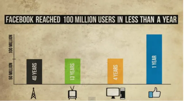
Fig 3.- Comparison between channels of information and communication.2
In 2014, the 42,3% of population in the world has Internet connection3. If we focus in this percentage, the most important applications with rapid development within the network have been social networks. If treated like only a channel of communication and information, we can compare with the rest of them. Fig 3 shows the incredible growth that this specific social network, Facebook4, has experienced, in comparison with traditional media. While radio,
television and Internet have needed between 40 and 4 years to have 50 million users, Facebook took less than a year to attract 100 million users.
2 http://www.lovesocial.org [accessed December 26th, 2014] 3 http://www.internetworldstats.com [accessed December 26th, 2014] 4 https://www.facebook.com [accessed December 26th, 2014]
Humans took information from public spaces (markets, social meetings…) in XIX century. Then, as humans needed more information, technology evolved and radio (late XIX and early XX) and television (around 1927) appeared. Nowadays, Internet, blogs and social networks are complementing radio and television with an unprecedented increase of users. Abraham Maslow [14] defined a pyramid that can explain some reasons of the increase of social networks in our society.
Fig 4.- Maslow’s pyramid. [14]
Pyramid (Fig 4) shows the humans’ social hierarchy needs. Social networks provide, in general terms, large doses of esteem and self-actualization to the user, the two terms in the top of the Maslow pyramid. [13] Thus, it is clear that social networks fill or refill two important terms for humans’ needs, promoting the unprecedented boom of social networks.
2.1.2. Space: a social component.
Fig 5.- Schema of Space’s section content.
Place is simply a geographic area that has meaning to people [15]. The study of placed-based theories and research on sense of place, place attachment, place dependence and place identity have made a critical contribution articulating the roles and meanings that places have in our lives [16]. These concepts are broadly defined [17], [18], [19], [20]. Sense of place is described as “an experiential process created by the setting, combined with what a
person brings to it” [17]. Place attachment is considered “the union of people to places” [18]. Meanwhile, place dependence is understood as the strong bond between a person and specific places [19]. Finally, place identity has been defined as interaction of someone in relation to the physical environment [20]. Some argue that sense of place, place dependence and place identity are forms of place attachment.[16] From now on, when this dissertation refers to place attachment is involving the others four terms.
2.1.2.1.
Place attachment
Place attachment to one’s home and local area is beneficial [21]. As much as possible, any participation with residence’s place is positive to create community outcomes. People with higher place attachment report greater social and political involvement in their communities [21]. Alternatively, they are more prone to successful teamwork [22] and to protect each other [21]. Moreover, high place attachment means better quality of life [22] and greater satisfaction with one's physical environment [23].
Fig 6.- Three-pole and four-dimensional conceptual model of place attachment. [24]
Fig 6, extracted from [24], shows a model of place attachment. Three poles overlapped in order to achieve a meaningful concept of place attachment compose this model. These three pillars are based on social psychology, environmental psychology and community sociology.
2.1.2.1.1. Place attachment in personal context
Different intensities of place attachment can be seen in personal context. These values depend on the degree of the relationship people-place, the size and the location of said place. Furthermore personal context depends on the interaction of someone in relation to the physical environment, the strength with the specific places and the roots established. Attachment to the place in a personal context can be predicted by certain social and
demographic factors. For example, it is stronger the feeling of belonging in a person who has bought a house than in another who is renting one [25]. But, what is the measure of this personal context? Studies have found that people give higher place attachment to their homes and surroundings than to their neighbourhoods. One possible explanation of these results could be that home is an easily definable space while neighbourhood is a broader concept [26]. As it was exposed above, Internet and social networks can strengthen the relationships of users in local areas in order to positively reassess neighbourhoods.
2.1.2.1.2. Place attachment in community context
The role of the community is an important input to create place attachment. The neighbourhood provides ideal scale for creating associations with diversity aims. As has already been pointed out, community attachment is strongly related to individual connections to local social networks (bonds) and the interactions between them. Kasarda and Janowitz [27] found that connections developed between people in a given place are more relevant than its population size or density.
There are two approaches to the concept of community in terms of space. First is the territorial and geographical notion of community. Second is the total number of residents and the connection between them without reference to location [27]. Gusfield [28], noted that both usages are not mutually exclusive. Modern societies with technological advances take less importance of people’s location to create a community, putting emphasis to sharing common interests. Nevertheless, facing the unstoppable process of globalization and cultural homogenization, there is a growing interest in the local context. It is in this environment where the geographical notion of community makes sense, which may be a determining and very powerful factor.
2.1.2.1.3. Place attachment in natural environment context
Last pillar of the Fig 6 is the connection to the natural environment without human beings (nature bonding). There are three ways to include natural environment identity as place attachment: environmental identity, emotional affinity towards nature, and connectedness to nature. [24]
2.1.2.2.
Dimension of place attachment and no-‐native inhabitants
Once the factors that take part in place attachment are exposed, the question is how to measure the dimension of place attachment. Some studies by Williams and colleagues [29] propose and validate 11 levels to evaluate and measure it. Among these levels, some are concerning nature bonding and social bonding, as proposed by Kyle et al. [30]. It seems that another logical approach to measure it are political and geographical boundaries, since there
is an inherent place attachment, result of living under the same delimitation and values. However, some of these boundaries are imposed, resulting from former political interests, historic events (war, treaties, etc.), geographic features, etc. which define the shape of countries, provinces, municipalities, etc.
Native or no-native nature in place attachment is studied deeply in a Hernández B. and colleagues’ paper. [26] From this study they extract interesting results concluding that the importance of being born in the place you live, in terms to value the place attachment. The following sentences are extracted from results of the investigation:
• “Results show that place attachment and place identity behave similarly in the case of natives born and raised in the same place but differently in the case of non-natives.
• Results also confirm that natives establish more intense links, whether of attachment or identity, with the island, the city and finally, with the neighbourhood where they live.
• Results show that neighbourhood lacks symbolism, while the city and particularly the island are heavily charged with content and relevant meaning. These results question the tradition of considering neighbourhood as the preferred place of attachment (Guest & Lee, 1983; Cuba & Hummon, 1993; Mannarini et al., 2006).”
2.1.3. Inhabitants and collectives
Fig 7.- Schema of Inhabitants/collectives section content.
2.1.3.1.
Inhabitants
The aim of this section is to list some opportunities and responsibilities that a responsible citizen must carry out in order to empower the relations and interactions of a given society. Bordieu [31] classifies between two kind of inhabitants: producers and consumers. Putting more weight of power in producers side. In contrast, Foucault [32] argues that power comes from everywhere. Producers or consumers, all of them are inhabitants and the public space is the meeting point where citizens interact with each other.
Inhabitant status represents a triple challenge to society, according to Borja, J. [33]: 1. Political challenge: preserves public policies that keep the rights of citizens.
2. Social challenge: promotes public policies that minimize the vulnerability of poor people.
3. (Only for urban environments): makes the city a producer of meaning to everyday life for citizens.
2.1.3.2.
Collectives
In Section 2.1.2.1.2 the community was defined from the point of view of space. In this section, it takes a social approach. In social sciences, ‘community’ cannot deny its roots in German sociology of XIX century under the name “Gemeinschaft” and whose invention corresponds to Ferdinand Tönnies in 1887 [34]. While “Gemeinschaft” (community) is inspired in the model of family ties, based on inherited and objectified social positions and relationships of intimacy and trust, “Gesellschaft” (association) is related to an ideal type of society based on impersonal relationships between strangers with independent links. It is accepted that the relationship between these concepts allowed society to evolve from a society based on kinship to one focused on contract and individual rights. This statement has different interpretations depending on the author’s point of view; while Tönnies regards “to feel the same thing” as “having the same feelings”[35], Durkheim interprets it as sharing the same sensations [36].
In order to distinguish between common and collective we must consider the study of Maurice Halbwachs [37]. A common memory is identical for all the members of certain society, while in a collective memory all members are articulating the distinct contribution, assuming distinct memories as well. The term ‘community’, based on common, is presented as a unique social body severely hierarchical that encloses its components in an organizational order. Nevertheless ‘collective’ term is associated with the idea of reaching an agreement that benefits all members, to achieve certain goal.
2.1.3.3.
Participation
Schlossberg and Shuford [38] define ‘public’ as those affected by a decision or program, who can bring important knowledge and who have power to influence the implementation. Relevant studies have addressed the complexity of participatory processes [39]–[41] giving more weight to participatory processes from top to bottom. Conversely, some studies in rural areas are focusing on how indigenous communities have articulated their participative process [42] [43], showing another kind of more decentralized participation. Horizontal processes where each inhabitant or collective can ask for participation to the others [42]. If the participatory process is well documented and communicated, each of the actors can give
a meaningful opinion and know the others’ vision [44]. Internet offers new channels of communication and organization that could enable true direct participation. The Network has allowed a degree of organization and citizen cooperation that goes far ahead of the modernization capacity of governmental organizations.
2.1.3.4.
Participation and Geographic Information System
Citizens handle a lot of information in their daily life, which includes complaints and opinions about their country, city/town or neighbourhood [45]. A big amount of tangible and intangible items in a city are available to be located in a position at a given time. This can be extrapolated to a multitude of areas and the resulting information can be analysed and visualized in a spatial way [46]. The demand of ubiquitous spatial applications is growing exponentially within all sectors of society [47]. But, how can GIS be involved in this participatory process? In 1996, a new discipline appeared: PPGIS. The following definition describes this topic: “Public Participation Geographic Information Systems (PPGIS) belong to the use of Geographic Information Systems (GIS) to broaden public involvement in policymaking as well as to the value of GIS to promote the goals of nongovernmental organizations, grassroots groups, and community-based organizations.” [48] From this definition, the main idea to be drawn is how PPGIS can extend and enforce public participation in order to be able to go along the generation of new policymaking approaches and strengthen the bonds of social organizations. Recognition that GIS can be a social technology implies that the GIS research agenda should be broadened to incorporate questions of the social site [49]. In certain ways, GIS is a good logic instrumental interlocutor for social science. The mapping of results and possibility to insert data to the map add another possibility to the user to interact with the process.
2.1.3.4.1. Volunteered geographic information, Participatory GIS and Public participation GIS
Nowadays, there are three important methodologies that merge participation and geographic information: VGI, PGIS and PPGIS. The difference between these three concepts is ambiguous, as researchers do not agree on the use between them [3]. Table 1 sums the characteristics of the three concepts, according to the point of view of Greg Brown and Marketta Kyttä [3]. As exposed before, the difference between them is still unclear, as this table includes generalization of concept’s uses, which are subject to exceptions.
Table 1.- Characteristics of PPGIS, PGIS and VGI. [3]
PPGIS are associated to developed countries and to enhancing public involvement to inform land use planning and management; while PGIS are used as a development tool in developing countries to achieve community empowerment and the creation of social capital. In many cases PGIS advocates more participation component than resulting maps. PPGIS also take care about social capital and enhancing community, albeit they regard it as secondary concepts. VGI typically uses citizen-initiated convenience sampling methods that generate individual mapping contributions [3]. VGI is closely related with “crowdsourcing” [50] and it is favoured by the increase of mapping applications.
Schlossberg and Shufford [38] note that “public” term in PPGIS is depending on its own definition. It may include “decision makers”, “affected individuals”, or the “random public”, among other groups. From this broad perspective, it makes sense not only to see GIS as a container of maps, if not as a tool to spatial decision-making [51], even more, as a provider of otherwise invisible or intangible geographical information [52].
Studies done by G. Brown et al. [3] demonstrate that participation rates in surveys have declining response rates in all methods. Internet-based methods, however, show 11% less responses rates than conventional modes. Moreover, comparing PPGIS web mode with paper mode, the rate is 2.5 times higher for the paper-based method. PPGIS was well received for those who saw the potential to gather knowledge from citizen experience, although there is still a big challenge in capturing the interest of lay people in participatory processes.
2.1.3.4.2. SoftGIS
“The descriptive term “soft” refers to the subjective and qualitative nature of the mapped attributes as a contrast to the “hard” spatial data layers usually associated with GIS.”[3] Furthermore, soft knowledge is based on people’s personal experiences, configuring a place with attributes coming from the memories, meanings and values of its inhabitants. SoftGIS methodology represents an improvement over PPGIS, as it enables to collect large data with user-friendly applications from citizens or groups of them. However, location-based approaches tend not to consider person environmental studies, neither within the social sciences tradition nor in environmental psychology studies. On the other hand, in Geography
takes places as the core of the discipline [1]. In order to confirm this point of view, it was introduced in previous sections the study of Lewicka [25] in which the focus of the revision is the person component instead the place or process components.
Map-based questionnaires [53] can be a suitable method to enhance and empower community organizations and stakeholders, further opening a way to create participatory processes by community organizations to enhance policy affairs. When citizen and stakeholders are motivated government intervention is needless. Resulting data from SoftGIS provides information that is not normally available. “Knowledge of the residents’ perceived quality and use of their living environment is particularly needed” [54]. Even more, it seems that planning processes are not prepared to incorporate this knowledge [55]. In fact, this is the motivation to develop SoftGIS; to fill the gap in planning process of perception and feelings of inhabitants. “This soft knowledge has been gathered and studied extensively, but it has not been systematically attached to places.” [54]
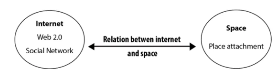
2.1.4. Relation between Internet and Space
Fig 8.- Schema of the relation between Internet and space
The irruption of technology in public spaces is changing the model of the society. In the past, emotional relationships were developed in a constant and close space (neighbourhood, cities, etc.) while nowadays they are also developed in a virtual space such as social networks. Internet is certainly one of the most extraordinary achievements of new technologies and its ability to complement the conventional public space must be considered.
The idea of global and globalization is a reality. However in opposition to this ideal, it also persists the resistance of the local space, where people’s experience is closer and face-to-face. Local uses of the Internet have shown to support the revitalization of local environment where they thrive. Therefore, a greater use of the Internet and the development of a digital culture is taking people out on the streets and bringing back many of the uses of the streets and the city [56].
On the other hand, virtual space is simulating public space like communication place, even though this virtual space, provided by the Internet, is growing stronger, people still identify their attachment with physic space [57]. Internet provides the tools to connect one local public space to others, forming a network of public spaces and feed on this connection.
2.1.5. Relation between Internet and Inhabitants/Collectives
Fig 9.- Schema of the relation between Internet and inhabitants/collectives
2.1.5.1.
Government
ICT are allowing specialized and general local/public spaces of dialogue, of different rank and size. And the new way of doing politics may be in the hands of these new public spaces. Though it involves new technology, Government 2.0 is really about a new approach to governance [58]. Nowadays it is possible to make processes more transparent with immediate participation. Surely, this is political leaders’ new main challenge in order to achieve democracy 2.0 or E-democracy [59].
2.1.5.2.
Citizen
Giovanni Sartori [60] argued in 1998 that we are in front of a genetic mutation, Homo sapiens, product of literacy, is being transformed into "homo videns" to whom the word has been dethroned by the image. According with this point of view, William Deresiewicz [61] thinks that the appearance of the camera has created a culture of celebrities and computers, a culture of connectivity. And Web 2.0 has enabled the convergence between them. For example, social networks merge both cultures: celebrities and connectivity. Thus, interaction allows individuals to be known, and it seems to be contemporary human’s main goal: “ to be visible” [61].
2.1.5.3.
Collectives
Technology itself can re-humanize social relationships [62]. New tools and channels of communication are awakening new consciences and collective values. If it is true and there is a strong local community recovered, new global consciences empower local collectives, thus providing several opportunities.
2.1.6. Relation between Space and Inhabitants/Collectives
A place is just a geographic area that has meaning to people [15], while inhabitants and collectives are the settlers of this place. In this relationship, technology can act in two directions, depending on how society uses it; on one hand it can cause offshoring, and on the other side it can also enable local approach a leading role. Internet’s nature is connecting people around the world. At the same time it can strengthen local and community relationships by sharing content. This philosophy, focused on collective participation, free access and freedom of use has given birth to a new type of more supportive and generous "society", where any professional can share knowledge, seeking to serve the common good. Periphery is no longer a geographical issue and has become almost a matter of attitude [63], where Internet plays a crucial role.
2.2. Similar applications
During the last few years, the number of social opinion applications has increased, thanks, in part, to the necessity for immediate communication and opinion by citizenship.
This section contains a brief description of some mobile and web applications. Section is divided in two parts: on one side there is a list of question based applications and on the other side, it is exposed some applications that ask for users support in social initiatives.
2.2.1. Question based applications
It is possible to distinguish between two different application formats; while some allow to create a unidirectional form in order to get answers for market research, others seek a two-way interaction, thus showing more concern about the users' point of view and enabling the sharing of information.
The ones presented in this list are applications of the second group. These platforms have appeared last years responding to the need of a channel through which people can express their opinion. Most of these applications are unknown to the general public, but in the coming years they have the potential to become a very useful tool. For each application there is a short description about its functions, the kind of interaction it enables with user and some relevant information.
Appgree
Appgree5 (Fig 11) is a web and mobile app that allows a different range of the population to communicate more easily. Its communication is bidirectional, but is always started by the site of the owner of the channel. Nowadays, Appgree is the most widespread application of the list because its easy way to merge hundreds or thousand voices into one and its flexibility
Fig 11.- Main web page of Appgree.
to create new interactions. It uses a breaking algorithm to analyse the opinion of a given amount of people and provide the most popular answer. This algorithm becomes more robust as more people respond. There are many channels available about different topics and some relevant political parties and enterprises are starting to use it to communicate with their users. QueryDay
QueryDay6 (Fig 12) is a mobile application that allows users to state their opinion through social voting. This application is the most similar to a social network from the list. Users can vote and comment on thousands of close questions, get real time opinions from their friends or the ones polled and get geolocated answers. QueryDay lets users interact with the system as a single anonymous user and sort questions by subject.
Fig 12.- Main web page of QueryDay
6
Your OPinion Platform(Yopp)
Yopp7 (Fig 13) is a mobile platform where users can give their opinion in shared form that
includes the other users’ opinions. This resourceful app enables users’ responses to be sent to decision-makers, whether in a neighbourhood, city or country scope, or their opinion groups. There is a two-way interaction; users can propose new questions for any group, public or private. Once the question is answered, the user is able to see the statistics of the responses. Users' opinions are anonymous and through them, a picture of user environment can be easily developed. Yopp allows the creation of groups (public or private) by users, while establishing a stable communication between government and citizens.
Fig 13.- Main web page of Your OPinion Platform (Yopp).
Safety GPS
SafetyGPS8 (Fig 14) is a mobile platform for exchanging information and geographic
location between entities and users. Any registered user can post a safety (message text, picture and position) to any entity registered on the platform. These safeties' functionalities are very broad: from reporting urban damage or abandoned vehicles to sending segmented notifications, sorted by topics, to any organization, or contact them on an emergency. Being a faster channel of communication than through conventional ones. In addition, users can read quickly and safely alerts sent by governmental organizations, for instance in the event of a natural disaster. SafetyGPS is the first platform that allows emergency communication with organizations that is 100% accessible to people with hearing and other disabilities. This is only a selection of applications currently available that are similar to parts of this dissertation's application. In Table 2 can be seen a comparative study of the different
7 http://youropinionplatform.net/index_es.php [accessed December 26th, 2014] 8 http://safetygps.com [accessed December 26th, 2014]
functionalities and main characteristics of the applications described above. This comparative is done by user perspective. Table 2 shows the main features and allows the reader to see the strengths and weaknesses of each application. At first glance, it is representative that none of them allow users to download the results of their own questions or safeties.
Fig 14.- Main mobile page of SafetyGPS.
Also, users cannot state their background, questioners cannot decide who they want to answer the questions, and there is no filter to set a geographical limit to send or receive notifications. Besides, none of the applications allow users to filter questions in order receive them sorted by topic. Queryday has the possibility to add a topic to the question, but when another follows a user, he or she receives all the questions created by the other user, in a similar way to Facebook4 notifications.
All the applications have representation in mobile platform and only Appgree can run in a computer with the same functionalities than mobile version. The geographic component for both sending and receiving questions, is present in some applications. While Yopp takes into account the geographical component to suggest groups and even to choose the interface language, Queryday shows the user a map segregating the answers by province limits, being this political limit the maximum scale of detail.
Table 2.- Comparative study of question based applications.
Appgree QueryDay Yopp SafetyGPS
Available platform Mobile App Web Platform Global distribution General functionalities Questions/group filter
Two-‐way free interaction
Create groups
Query/user search
Geographic group suggestion
User capabilities
Anonymous user
Users interaction
Available actions according user position
Questions and answers
Open questions
Share contents
Comment content
Filter questions to receive
Results
Open Results
Real time Results
Download Results
Segregate Results
Geographic Results
2.2.2. Support based applications
These platforms have appeared also during the last year, responding to the need to connect people in order to achieve a better world. The operation of the application is similar in all the applications of this kind. Citizens or a collective initiates an action to change something and the other users can support the initiative by signing the petition. Users or collective can also declare the minimum amount of signatures for the success and they can attach the addressee to whom the petition is directed.
Unlike last section, this one does not present a list with a short description of each application because their functionalities and procedure are very similar. Instead, there is a comparative table to show the main features, allowing the reader to see the strengths and weaknesses of each application. There are few applications that enable users to support initiatives for social change. Surely, change.org9 is the most famous and widespread around the world, followed, certainly, by care210. These two applications are the most important social change petition-based applications.
In Table 3 there is a comparative study of the different functionalities and main characteristics of change.org and care2. For the aim of this dissertation it is very surprising that none of them have taken the geographical component into account, neither in sharing petitions nor in filtering them. It is not possible to know who has signed the petition and only the petition’s owner has this privilege. As it would seem logical, it is not possible to sign any initiative as an anonymous user. Finally, change.org do not enable users to filter petitions neither by subject nor by delimitation, while in care2 subjects can be filtered. For instance, in order to find some petition related to your municipality you have to find manually the municipality’s name that appears in the heading of the petition, if it appears.
9 https://www.change.org [accessed December 26th, 2014] 10 http://www.care2.com [accessed December 26th, 2014]
Change.org Care2 Available platform Mobile App Web Platform Global distribution Doing petition Subject notation Sharing Facebook/twitter
Sharing by email
Sharing by geographical limit
User capabilities
Anonymous user
Users interaction
Available petition according users’ position
Searching petition Filter by location
Filter by subject
Signing a petition
Comment signature
Real time Results
Download Results
Subjective impression(*) Easy interface
The application described has the possibility to engage citizens in PPGIS or PGIS
processes (see Section 3.5.3.5). These kinds of practices are typical from government
or, in less measure, associations. For example, there are few cases of this nature in
Spain using Internet technologies, moreover they are isolated and almost all cases are
created by city councils in planning policy-making. This dissertation’s application
provides to any collective registered, the possibility to create participative processes
and send wherever, generating discussion and new points of view.
This chapter shows how there is still big room for improving different aspects like the interaction between inhabitants and collectives, easy access, performance, etc. There is an important lack of geographical features in all the last section’s applications, which share their content only in social networks and through mailing. Besides implementing more functionalities, the application described in this dissertation aims to fill the gaps in Table 2 and Table 3, understanding that geographical filtering, accessible data and sorting of information according to your interests, must be very important features for an application of this nature.
2.3. Study Cases
Final part of the chapter is related with two study cases. As it was shown in Section 2.2, it is still big room for improvement in different aspects of the current applications of this thematic. Overall, this dissertation’s main goal is to insert geographical component to an application of this nature, and, in fact, the aim of this section is to show some cases where the spatial component has been forgotten and why it is crucial to attend to this matter. There is an important lack of geographic component in applications showed, understanding that geographical filtering must be an essential and very useful tool to movement for social change.
In order to prove how spatial tools can help and optimize this kind of applications, there is here exposed one case extracted form change.org. It covers an issue in a municipality (La Garriga, Catalonia, Spain) with the aim to change something thanks to support from users. Furthermore, there is an example of a political party willing to prove their transparency in Barcelona: Guanyem11. Finally, the last section of this chapter introduces some hypothetical
case where application described in this document can help different users.
2.3.1. Picnic area case
Bordalla12 Association is an assembly of young people in La Garriga that started an initiative on 24th November 2014 against the construction of a picnic area in the municipality of
Cànoves-Samalús. The council of Cànoves-Samalús approved a project for a picnic area in a rural environment, which affected neighbouring towns such as La Garriga, since to arrive to the picnic area it is mandatory to pass through this town. The initiative wanted to collect signatures to pressure Cànoves-Samalús’ council to give up this idea. In general terms, Bordalla’s reasons to create this initiative are the risk of fire, destruction of the landscape and project deficiencies on the sewage system.
Fig 15.- Image of picnic area project and suuroundings
By the time this dissertation has been written (January 2015), the initiative has achieved 490 signatures distributed in 134 different areas.
Fig 16 shows the participation among representative municipalities. There are 134 areas involved in the petition and this 8 representative municipalities represent around 66,50% of the total signatures. The other components of the list do not exceed 3 votes, being 89 areas with one vote. At first glance, it is very surprising the percentage of votes from La Garriga (53,06%). This issue can be a result of the arguments exposed before, or due to the fact that Bordalla is an association based in La Garriga. The second higher value in the chart is Barcelona with 31 signatures (6,33%); it is not surprising, since Barcelona has more population than the rest of the municipalities, but focusing on what amount of people represents this percentage for Barcelona (right column), percentage of signing population is the lowest of the figure. The rest of the items are municipalities from the same comarca
county- (Vallès Oriental) where the picnic project area is located. As an anecdote, there is one vote from New York and another from United Kingdom (UK) being the only two signatures from outside Spain, demonstrating the internationality of change.org.
Fig 16.- Percentage of signatures per municipality (*) representative municipalities.
Fig 17.- Spatial distribution of Figure 16
Fig 17 represents spatial distribution of these 8 municipalities; only Barcelona is outside the comarca of Vallès Oriental. This map illustrates that the participation increases as the distance from the place decreases. From the eight highest values from the list (66,50% of the total), 57,95% are neighbouring towns, while 60,20% are municipalities from the same comarca (Vallès Oriental). Future work can be lead to find out which percentage of
Barcelona’s voters was born in La Garriga or are bonded with the town.
Attending to the percentages, it is possible to see that it would make sense to implement a new functionality in change.org in order to enable petitions to be sent to certain geographic limits, to increase diffusion. This new functionality does not need to replace the current methods of sharing petitions through social networks and mailing list, but it can be regarded as another channel to spread the petitions. As seen in the example above, it would represent, at least for local issues, a useful new feature.
2.3.2. Guanyem’s case
Guanyem11 is a new political party that is going to run in the upcoming municipal elections (May 24th 2015) for the city council of Barcelona.
In July 14th 2014 the following headline appeared in a newspaper13: “ “Guanyem” quiere ganar los barrios preguntándoles.” “ “Guanyem” wants to win the neighbourhoods by asking them.”
In order to achieve this proposal Guanyem used Appgree as a participation channel. In Section 2.2 the characteristics of this application were reviewed and the lack of the spatial component was pointed. Moreover, Guanyem understood that the decentralization of power is essential in order to achieve a better management and thus, there are created commissions in all the neighbourhoods of Barcelona that deal with local problems and advocated for participation, diffusion, transparency and collaboration.
The application described in this dissertation also regards decentralization and local management as essential to understanding better local social problems. (see Fig 22) The application described can provide the spatial component to Guanyem’s vision in order to understand opinions and problems at district level, instead of just having a general overview. Furthermore, Appgree channels are public and users from anywhere can enter the Guanyem Barcelona channel and give their opinion and send their answers through the channel. Then, a question appears: does it make sense to take into account the votes of citizens outside Barcelona in policy-making affairs? It is not an answer with easy solution, but at least it is a question to consider.
13

![Fig 4.- Maslow’s pyramid. [14]](https://thumb-eu.123doks.com/thumbv2/123dok_br/15636388.1056893/19.892.268.642.343.610/fig-maslow-s-pyramid.webp)
![Fig 6.- Three-pole and four-dimensional conceptual model of place attachment. [24]](https://thumb-eu.123doks.com/thumbv2/123dok_br/15636388.1056893/20.892.171.742.534.855/fig-pole-dimensional-conceptual-model-place-attachment.webp)
![Table 1.- Characteristics of PPGIS, PGIS and VGI. [3]](https://thumb-eu.123doks.com/thumbv2/123dok_br/15636388.1056893/25.892.151.767.122.255/table-characteristics-ppgis-pgis-vgi.webp)