Late Holocene evolution of the lower Tagus alluvial plain and heavy metals content : preliminary results
16
0
0
Texto
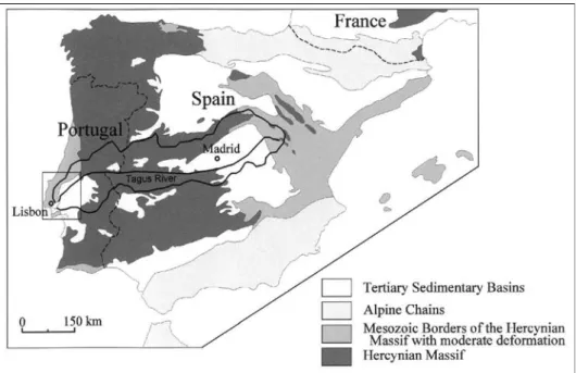
(2) C. Ramos, E. Reis, A. Ramos Pereira, T.M. Azevedo, E. Nunes, M.C. Freitas & C. Andrade. 1. Geological and geomorphological framework This work has been undertaken in the scope of the Praxis XXI Project untitled “An interdisciplinary approach to flood risk evaluation - hydrology, geomorphology and sedimentology of the Douro, Tagus and Sado Basins (IDAFRE)”. This paper aims to contribute to the fluvial dynamic knowledge of the Lower Tagus during the late Holocene, based on the sedimentological and geochemical analysis of the sediments from two cores. The cores were done in different geomorphologic positions chosen in the alluvial plain. The Tagus hydrographic basin has 80,629 km2 (55,769 km 2 in Spain and 24,860 km 2 in Portugal; Figure 1). In Portugal, this basin shows a strong morphologic and climatic dissymmetry between the two margins. The northern margin is more rainy (9002,000mm per year) than the southern (500-900mm per year). This contrast reflects a set of geomorphological features namely the Central Cordillera in the Hercynian Massif (granites and shales of the Central Iberian Zone) and the small limestone mountains (Aire, Candeeiros and Montejunto) in the Mesocenozoic Sedimentary Basin. The southern margin is lower and has several planation surfaces that cut the Hercynian and the Precambrian rocks (migmatitic shales and granites of the Ossa Morena Zone) and also the Miopliocene sediments (sandstones, conglomerates and clays with limestone layers) of the Tagus Cenozoic Sedimentary Basin. The sedimentary sequence is composed by 300 to 700 m thickness of continental siliciclastics sedi-. Figure 1. Structural framework of Tagus drainage basin (the square represents the more detailed map of figure 2).. 164.
(3) Late holocene evolution of the lower Tagus alluvian plain and heavy metals content: preliminary results. Figure 2 - Geomorphological framework of the Lower Tagus Basin. (D.B. Ferreira, 1980, simplified). ments, on both banks of the river. This sequence is best developed on the left bank of the Tagus (Figure 1), while the right bank has lutitic and carbonated sediments. The sediments thickness growths towards the center of the basin, from 400m at Pernes to 500600m at Ota (Barbosa, 1985) and about 1200m in the Peninsula of Setúbal or near V.F. de Xira, near the depocentre of the Basin. The diversified lithology of the Basin frame area as well as the great thickness and the low resistance to erosion of the tertiary infilling are responsible by the abundant and diversified nourishment of the Basin during the Pleistocene and the Holocene. Since the infilling reflects the geological framework of the Basin, its knowledge is specially important to identify the source of the heavy metals concentrations and to distinguish what is due to anthropogenic action. The Tagus valley can be divided in two geomorphologic sections. In the upstream section, between the Spanish border and Almourol, crossing the Hercynian Massif, the ENE-WSWvalley is deep and narrow, in special when it crosses quartzitic ridges or more resistant granites, and broadens when crossing small tectonic depressions. In the second section the valley broadens remarkably, since the river enters the wide Cenozoic Sedimentary Basin, flowing from NE to SW as far as Lisbon. This section is known as the Lower Tagus (LT). The valley is then dissymmetric because of the larger terraces on the left bank (Figure 2), probably related to the Lower Tagus fault. 165.
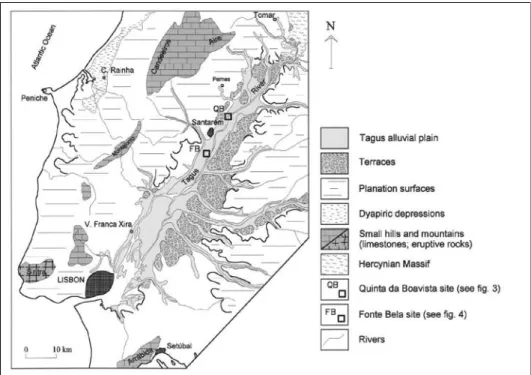
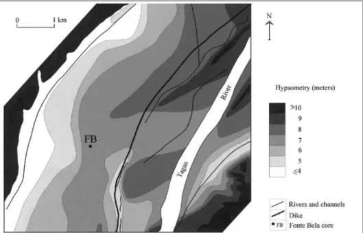
(4) C. Ramos, E. Reis, A. Ramos Pereira, T.M. Azevedo, E. Nunes, M.C. Freitas & C. Andrade. The LT alluvial plain is 5 to 15 km width and it gets the greater floods of Portugal, spreading over more than 800 km2. 2. Methodology The two core sites have been choose in different geomorphological positions in the LT alluvial plain (Figure 2): the Quinta da Boavista site is placed in the right bank of the Tagus main channel (Figure 3), while the Fonte Bela site, also in the right margin, is 2.5 km far from the main channel (Figure 4). The detailed alluvial plain morphology that frame the Quinta da Boavista core (Figure 3) shows several elongated lower areas that have been use to built ditches to improve the alluvial plain drainage and to irrigate the near agricultural areas. These lower areas witness the several positions of the Tagus main channel in its lateral migration, from east to west. On the opposite, the Fonte Bela core (Figure 4) was taken in an area with more calm sedimentation, between the present bars and the palaeochannel of the river. The coring sites were coordinated and connected to the UTM grid and Portuguese vertical Datum (mean sea level – msl). In the graphs of the sedimentological and geochemical data, the zero meters correspond to 6.5m above msl, at Quinta da Boavista (where the core reached 3.70 m) and to 5.32m above msl at Fonte Bela (where the core reached 7.40m).. Figure 3 - Morphological frame of Quinta da Boavista site.. 166.
(5) Late holocene evolution of the lower Tagus alluvian plain and heavy metals content: preliminary results. Figure 4 - morphological frame of Fonte Bela site.. At Fonte Bela, between 0 and 2.50m, sampling was carried in an irrigation ditch wall using 20 cm long and 5 cm diameter PVC tubes. From 2.50m to 7.40m, the sediment core was taken using 50 mm and 35mm diameter steel gauge augers, below ground surface where lateral and bottom attrition prevented further penetration. This last procedure was also used at Quinta da Boavista. The sediment cores were wrapped in plastic foil, transferred to plastic guttering, and taken for laboratory analysis. In the laboratory, each cored segment was opened longitudinally and described macroscopically. Both halves were then sub-sampled for sedimentological and geochemical analyses. Eighty-six (thirty eight at Quinta da Boavista and forty eight at Fonte Bela) whole rock (dried) sediment samples were analyzed by fusion inductively coupled plasma emission / mass spectrometry (ICP/MS) and instrumental neutron activation analysis (Activation Laboratories Ltd., Canada) for 37 major and several trace elements. Nine heavy metals have been selected (As, Au, Co, Cr, Cs, Cu, Fe, Pb e Zn) to illustrate the main kind of variation along the core or to show the surface contaminations due to human activity. We must emphasize that some heavy metals, for example the Hg, was not taken into account because its tenor was always below the detection threshold. The sediment samples collected for dating consisted of thin (1-2 cm) slices of muds. Samples were dated by standard accelerated mass spectrometry (AMS) and 14C radiometric determination at Beta Analytic Inc., USA. Calibration of radiocarbon dates was performed according to Vogel et al. (1993), Talma and Vogel (1993) and Stuiver et al. (1993). 167.
(6) C. Ramos, E. Reis, A. Ramos Pereira, T.M. Azevedo, E. Nunes, M.C. Freitas & C. Andrade. Figure 5 - Geochemical background value definition of the nine heavy metals at Fonte Bela.. The sedimentological study included the granulometric analysis of the whole sample. The sandy fraction (coarser than 63 µm) was sieved at 1f interval. The textural classification follows Folk & Ward (1957) and statistics of grain size distribution were calculated using the method of moments. The finer grained sediments (3 and 4 f) were sampled for heavy mineral suites, which were then mounted on thin plates for microscopic observation. The silty-clayed fraction (finer than 63 µm) was analyzed by a Philips X’Pert difractometer with the data being treated by a Philips Profile Fit programme. The mineralogy of the clays was identified and quantified along the profiles. The identification of the contaminants in the sediments of the alluvial plain and in those of the main channel assumes that the geochemical background is known. These values correspond to the heavy metal tenor in natural conditions, i.e., without relevant influence of human activities. Nevertheless, such values were never establishes before for the LT. To establish the geochemical background of each heavy metal we must know its depth variation. These values can be obtained by simple statistical procedures. As the heavy metals tenors depend mainly of the silty-clayed fraction, those values were weighed by the percentage of each fraction to eliminate silty-clayed influence. The geochemical background behavior was established using the two cores, after the definition of the general pattern. For each chemical element the average tenor was calculated, first taking into account the all cores and after the surface layers were removed 168.
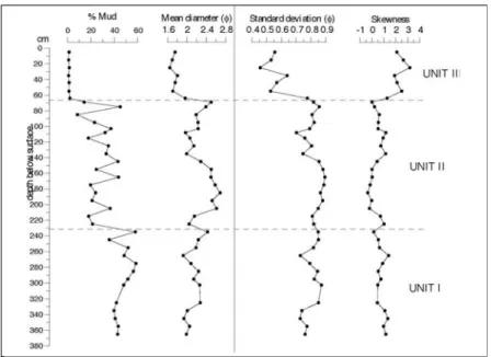
(7) Late holocene evolution of the lower Tagus alluvian plain and heavy metals content: preliminary results. successively until the mean value of each element reached stabilization. At this point the geochemical background was found (Figure 5). This methodology was applied to both cores. The heavy metal content lower with deep and the average values of each element get closer (Figure 6), reaching the background values. The lowest and the stabilized values were achieved in the deeper sedimentologic unit (250 to 740 cm – unit I) of Fonte Bela core (Figure 5). The analysis of data shows that there is a heavy metal contamination of the alluvial sediments when its tenors exceed three standard deviations the geochemical background. This procedure agrees with the conclusions present in the study of the marsh sediments of the Tagus estuary (Freitas et al, 1999).. Figure 6 - Comparision of geochemical background values from Fonte Bela (FB) core and those founded in Quinta da Boavista (QB9 core using average values for two different range depths.. 3. Sedimentological and geochemical analysis of Fonte Bela core The sedimentological study of Fonte Bela core allowed the definition of three sedimentary units (Units I to III) – table 1 and figure 7. Unit I (740 – 250 cm) – The basal unit consists essentially of mud and occasionally of muddy sands, the mud content averaging 90% of the total sample (between 44% and 99%). The topmost sample corresponds to muddy sand and most probably represents a lag deposit resting in the bottom of the ditch. Unit II (250 – 90 cm) – The intermediate unit consists of muddy sands, the mud content averaging 21% of the total sample (between 12% and 32%). The sand component is always fine, well sorted in its lower section and moderately sorted in the upper section (Figure 7); sorting decreases systematically up core, more pronouncedly above 135 cm, concomitant with increasing mean diameter (Figure 7). The skewness index remains fairly constant and negative across this unit. 169.
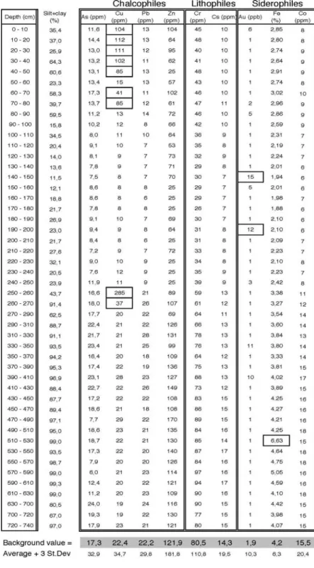
(8) C. Ramos, E. Reis, A. Ramos Pereira, T.M. Azevedo, E. Nunes, M.C. Freitas & C. Andrade. Table 1 - Heavy metals contamination at Fonte Bela core.. 170.
(9) Late holocene evolution of the lower Tagus alluvian plain and heavy metals content: preliminary results. Figure 7. Vertical profile of Fonte Bela core: mud content and textual parameters of sand fraction.. Unit III (90 cm – surface) – The upper unit consists of alternating muddy sand and sandy mud, the mud content varying between 23% and 64% of the sample and averaging 45%. The sand fraction is once again fine, moderately sorted and strongly negatively skewed. The oscillations found in the sand : mud ratio that exceeds the variations found in the intermediate unit, it is not translated into the vertical variation of the size distribution statistics of the sand fraction. In fact, the up core variation of the mean diameter and sorting index closely match the trends displayed by Unit II. The location of the coring site in an agriculture farmland may influence the large amplitude oscillations found in the mud/sand content. The opening of the irrigation ditch where the core was done exploit the contact between unites I and II, the first one with fine and massive sediments and the second mainly sandy. The heavy metals contents show the influence of the sediments texture; the higher values corresponding to the increase of the silty-clayed content (Figure 8). The gold is the exception. The highest tenors were found in the deepest unit (I), decreasing in the unit II and increasing again in the surface unit (III). About the 250cm deep, between units II and I, there is always a peak or a clear increase of all chemical elements (as well as about an increase of 20% of the silty-clayed fraction). Besides the texture effect, the presence of the bottom of the ditch at this level is the main reason to explain the increase of tenors at 250cm. The water stored in the irrigation ditch comes from the superficial soil wash of vineyards. The 171.
(10) C. Ramos, E. Reis, A. Ramos Pereira, T.M. Azevedo, E. Nunes, M.C. Freitas & C. Andrade. Figure 8 - Heavy metals contents fo Fonte Bela core.. vineyards are usually submitted to copper sulphate that contaminates the water and it is responsible for the Cu peak that reached 285ppm at the bottom of the ditch (between 250 and 260cm). The Cu value decreases to 37ppm (at 260-270 cm) despite the increase of the silty-clayed fraction (from 44% at 250-260cm to 91% at 260-270cm; table 1). All the values, except Cu, are below the threshold values of heavy metals in alkaline agriculture soils (pH from 7.9 to 8.3) established by the European and Portuguese legislation (table 1). Besides the high Cu value at the bottom of the ditch, the Cu values are always higher between 80cm and the surface independently of sediment texture, namely in the first 40cm, where the Cu is always above 100ppm. Taking into account that the threshold value for Cu in soils with 5.5<pH<7.0 is 100ppm (this value is 200ppm in soils with pH>7.0 and with agriculture for animal consumption, which is not the case) , the founded content show a clear Cu contamination in the LT alluvial soils. 4. Sedimentological and geochemical analysis of Quinta da Boavista core The results of Quinta da Boavista core show a clearly decreasing trend in the fine sedimentation through time (table 2). The sedimentological as well as the geochemical study of the core allowed the definition of three major sedimentary units (Units I to III) – Figure 9. Unit I (370 – 230 cm) – The basal unit consists essentially of muddy sands and sandy mud, the mud content averaging 48% of the total sample (from 36 to 59%). The sand component is fine, moderately sorted and always positively skewed (Figure 9). Unit II (230 – 68 cm) – The intermediate unit consists of slightly muddy sands to sandy mud, the mud content averaging 28% of the total sample (from 9 to 45%). The sand component is again fine and moderately sorted; the skewness parameter indicates predominance of positive values but a few symmetrical or negatively skewed samples occur (Figure 9). 172.
(11) Late holocene evolution of the lower Tagus alluvian plain and heavy metals content: preliminary results. Figure 9 - Vertical profile of Quinta da Boavista core: mud content and extual parameters of sand fraction.. Unit III (68 cm – surface) – The upper unit consists of clean to slightly muddy sands, the sand content always reach 98%. Sediment is represented by medium, moderately sorted (although better sorted than units I and II) and strongly positively skewed sand. The amplitude of the sorting index exceeds by a factor of two the equivalent range found in both the basal and intermediate units and decreases upcore (Figure 9). The sand : mud ratio varies within each sedimentary unit defining a number of positive and negative oscillations around the mean, with fairly constant amplitude. Yet, the transitions between adjacent units are characterized by sharp drops of the mud proportion, which shows a general decreasing trend towards the top of the column (Figure 9). In general, the grain size distribution of the sand fraction shows positive skewness. 5. Comparison of the two cores results The sedimentary column of Quinta da Boavista and Fonte Bela sites shares a threefold architecture, the transition between the lower and intermediate units in both sites being characterized by a marked decrease of the mud proportion. The top units are not comparable in this respect because Quinta da Boavista represents marginal channel sedimentation while Fonte Bela lies within the floodplain. The contrasting textural signatures of sediments cored in both sites (Figure 11) indicate that hydrodynamics, sediment sources or location relative to the main distributaries were different. In what concerns the mineralogy of the sand’s heavy fraction, very similar assemblages were found along both profiles: andalusite, tourmaline, zircon, sillimanite (fibrous and granular), green hornblende, garnet, staurolite and disthene. 173.
(12) C. Ramos, E. Reis, A. Ramos Pereira, T.M. Azevedo, E. Nunes, M.C. Freitas & C. Andrade. Figure 10 - Heavy metals contents of Quinta da Boavista core.. However, since the Fonte Bela (FB) assemblage clearly shows depositional episodes of very weak energy of flux, expressed by very high contents in biotite (often euhedrical) and less dense minerals, Quinta da Boavista (QB) presents higher concentration of denser grains such as garnets and zircons, rare biotite and some grains of apatite. All the grains are quite angulous showing slight maturity of sediments and short distance of transport, exception made to well-rounded garnet grains. In a sedimentological study of the Tagus estuary (Oliveira, 1967), the heavy minerals were analyzed with great detail and 7 different assemblages were found. One of them, “assemblage B”, was just the same that was found in this work and its area of distribution is «almost all of the estuary», which means that it is the most ubiquitous of all. Trying to find the rock source of these minerals, the author sampled the area upstream of the estuary, one of the samples being picked just in Santarém. The assemblage was again the same including the green hornblende and garnet. Once in the proximity of the estuary there are no rocks containing these two minerals; the explanation can only be the supply in the metamorphic rocks of the «Shale and greywacke Complex» (C.X.G.) that occurs in a more upstream segment of the river. The “assemblage C” - tourmaline, andalusite and staurolite with almost total lack of hornblende and garnet – is in turn originated in the continental Miocene and Pliocene sediments of the left bank of the estuary. Comparing these conclusions with the FB and QB profiles, it becomes clear that the sources of the heavy minerals found in both profiles are: a) the Paleozoic high-grade metamorphic rocks of the “Blastomylonitic zone”, preferably from the C.X.G. and localized downstream from it, for biotite, staurolite, silimanite, green hornblende, andalusite, angulous garnet, zircon and kainite; b) the sediments of the Tertiary Basin, that were in turn derived from the granitic and pegmatitic rocks of the Niza region (left margin), for tourmaline, andalusite and rounded garnet. 174.
(13) Late holocene evolution of the lower Tagus alluvian plain and heavy metals content: preliminary results. Table 2 - Heavy metals contamination at Quinta da Boavista core.. 175.
(14) C. Ramos, E. Reis, A. Ramos Pereira, T.M. Azevedo, E. Nunes, M.C. Freitas & C. Andrade. Figure 11 - plot of grain size distribution statistics (sand fraction) of sediments from Quinta da Boavista and Fonte Bela.. The methodological approach use in heavy metal analysis allow to recognize the Cu contamination in the superficial 50cm of the soil at Fonte Bela (table 1), where the tenors exceed 4 to 5 times the background value. Between 60 and 80cm deep it reach 2 to 4 times the background value. At the bottom of the ditch, between 250 and 270cm, the contamination is 13 times the background value. At Quinta da Boavista (table 2) the Cu, Pb and Cr contamination can be recognized in the superficial 70cm: 68cm belong to the surface sandy unit and 2cm to the unit II (where the silty-clayed fraction increase from 2% to 14%). This concentration shows not only the contamination but also the vertical migration of these elements and its retention by the silty-clayed fraction. At 10 and 20cm the Cu contamination reach 9 times the background value and between 30-40cm and 68-70cm this value is twice higher. The Pb is 1.4 times the background value between 10 and 20cm. The Cr reaches 250ppm between 68 and 70cm, i.e., 3 times the background value. The Cr highest values in this site can be related to the vicinity of the Tagus tributary River Alviela mouth, where tanning industries where settled. If we compare these results with those obtained by Freitas et al (1999), in the Seixal marsh of the Tagus estuary, we notice that the Zn and the As go along with the referred heavy metals and that they are related to chemical and metal-mechanic industries settled in the estuary. 6. Conclusions Both cores whether they are placed in the Tagus main channel (Quinta da Boavista) or whether they are 2.5km far from it in the alluvial plain show 3 sedimentological units. As several authors have mentioned before (Marriott, 1992; Asselman & Middelkoop, 1995), there is a relation between the morphology of the alluvial plain that frame the cores and the spatial textural variation of the sediments. In the studied case the sedimentological changes can be ascribed to lateral migration of the fluvial channel in the flood plain. 176.
(15) Late holocene evolution of the lower Tagus alluvian plain and heavy metals content: preliminary results. At Quinta da Boavista, in the right bank of a concave meander of the main channel, the decrease of the fine sedimentation through time (from 48% to 1%, between units I and III) is probably related to the forthcoming of the main channel, in an environment of increasing energy and a decrease of the fine sedimentation. The traces of the old channels on the left bank add to this conclusion. The 3 chronological data that was possible to obtain (due to the very low organic matter content), all in unit II, probably belong to a forthcoming of the main channel environment. They show an irregular sedimentation rate. The data were obtained from sediments at 163cm, 133cm and 129cm deep and the results have been 4020 ± 40 BP, 3920 ± 40 BP and 3480 ± 40 BP. The different evaluated sedimentation rates are of 3 mm/year between 163 and 133cm and 0.1 mm/year between 133 and 129 cm. At Fonte Bela, the higher silty-clayed fraction (90%) in the older unit (I) shows a more calm sedimentation environment, with low energy, like a lake or a swamp (?), sheltered from the main channel by a bar. In the unit II the silty-clayed fraction decreases to 21%, showing a clear rupture with the previous conditions, now in a more energetic environment (very similar to the unit II of Quinta da Boavista). The unit I witness the present conditions, i.e., the environment of the alluvial plain far from the main channel and from the bar deposits, where the fine sedimentation is higher (45%). The 3 chronological data reveal the following results: 70 ± 40 BP at 30cm deep, 1090 ± 70 BP at 70cm and 3400 ± 40 BP at 740 cm. The values show once again very different sedimentary rates: 2.9 mm/year between 740 and 70 cm deep; 0.4 mm/year between 70 and 30 cm, and 2.5 mm/year between 30 cm and the surface. The heavy metals tenors show an increasing and diversified contamination of the fluvial sediments (Cu due to cooper sulphate vineyards) as well as the irrigation ditches and fluvial channels (with higher tenors in Cu, Pb due to oil contaminants and Cr from the tanning industries). In the marshes downstream, the Cu tenors decrease while the Zn and As increase due to the chemical industries settled along the estuary. References Asselman, N.E.M.and Middelkoop, H. (1995). Floodplain sedimentation: quantities, patterns and processes. Earth Surface Processes and Landforms, 20 (6): 481-499. Ansari, A.A., Singh, I.B. and Tobschall, H.J. (2000). Importance of geomorphology and sedimentation processes for metal dispersion in sediments and soils of the Ganga Plain: identification of geochemical domains. Chemical Geology, 162: 245-266. Aswathanarayana, U. (1995). Geoenvironment. An introduction. A.A. Balkema, Brookfield, Rotterdam. Folk, R.L. and Ward, W.C. (1957). Brazos River Bar: a study in the significance of grain size parameters. Journal of Sedimentary Petrology, 27(1): 3-26. Freitas, M.C., Andrade, C., Moreno, J.C., Munhá, J.M. and Cachão, M. (1999). The sedimentary record of recent (last 500 years) environmental changes in the Seixal Bay marsh, Tagus estuary, Portugal. Geologie en Mijnbouw, 77: 283-293. 177.
(16) C. Ramos, E. Reis, A. Ramos Pereira, T.M. Azevedo, E. Nunes, M.C. Freitas & C. Andrade. Marriott, S. (1992). Textural analysis and modelling of a flood deposit. Earth Surface Processes and Landforms, 17 (7): 687-697. Stuiver, M. Long, A., Kra, R.S. and Devine, J.M. (1993). Calibration - 1993. Radiocarbon, 35. Talma, A.S. and Vogel, J.C. (1993). A simplified approach to calibrating C14 dates. Radiocarbon, 35: 317-322. Vogel, J.C., Fuls, A., Visser, E. and Becker, B. (1993) - Pretoria Calibration Curve for Short Lived Samples. Radiocarbon, 35: 73-86.. 178.
(17)
Imagem

+7


Documentos relacionados
As a conclusion, considering that the average lifespan of a Web document is of 140 days [2], equivalently 4.5 months, the fact of finding a great number of documents for the two
The L ower Tagll s Basin (LTB ) occupies a large area in Portugal, from the lilloral region of Lisbon-Seulbal Penin - sula , to beyond spa nish border near Castelo Branco (Beira
Tide and wind control of megalopal supply to estuarine crab populations on the Portuguese west coast
We addressed these problems by obtaining daily series of abundance of megalopae in the plankton, settle- ment of megalopae on bottom-deployed collectors, and physical parameters
After a preliminary characterization of the materials (organic matter content, volatile solid, and heavy metals content), heavy metal accumulation in soil caused by
Late Pleistocene and Holocene palaeogeography of the Lower Tagus Valley (Portugal): effects of relative sea level, valley morphology and sediment supply. In search of homelands:
In the present study, the shoots and roots dry matter yield, the B and heavy metals’ concentration in the plants and the total content of the element extracted varied de- pending on
The obtained data in different regions revealed that the content of sodium in the camel milk from Riyadh region of Saudi Arabia measured by atomic absorption spectroscopy was
Estamos perante uma necessidade de analisarmos todas as interações existentes neste contexto de aprendizagem, ou seja, não podemos isolar cada criança, nem o adulto e/ou
