Braz. J. of Develop., Curitiba, v. 5, n. 7, p. 8464-8474 jul. 2019 ISSN 2525-8761
Geoprocessing as a tool for environmental quality analysis in urban lagoon
Geoprocessamento como ferramenta para análise de qualidade ambiental
em lagoa urbana
DOI:10.34117/bjdv5n7-062
Recebimento dos originais:12/05/2019 Aceitação para publicação: 25/06/2019
Leonardo Monjardim Amarante
Engenheiro Agrônomo, Pós Graduado em Engenharia Ambiental, Mestre em Engenharia e Desenvolvimento Sustentável
Instituição: Universidade Federal do Espírito Santo
Endereço: Av. Fernando Ferrari, 514 - Goiabeiras, Vitória - ES, 29075-910 E-mail: [email protected]
Denise Machado Poton Engenheira Ambiental
Instituição: Faculdade Pitágoras Unidade Guarapari
Endereço: Rod. Jones dos Santos Neves, 1000 - Lagoa Funda, Guarapari - ES, 29214-005 E-mail: [email protected]
Marcelo Zucateli Cunha Engenheiro Ambiental
Instituição: Faculdade Pitágoras Unidade Guarapari
Endereço: Rod. Jones dos Santos Neves, 1000 - Lagoa Funda, Guarapari - ES, 29214-005 E-mail: [email protected]
Jackson Santana Ferreira Engenheiro Ambiental
Instituição: Faculdade Pitágoras Unidade Guarapari
Endereço: Rod. Jones dos Santos Neves, 1000 - Lagoa Funda, Guarapari - ES, 29214-005 E-mail: [email protected]
Murilo Petri Calanzani Engenheiro Ambiental
Instituição: Faculdade Pitágoras Unidade Guarapari
Endereço: Rod. Jones dos Santos Neves, 1000 - Lagoa Funda, Guarapari - ES, 29214-005 E-mail: [email protected]
ABSTRACT
Lagoa das Garças is totally eutrophic, mainly due to the launch of domestic and industrial effluents and the surface runoff. In order to promote the recovery of the lagoon, the document suggests the detection of pollutant sources by means of measures such as the mapping of
Braz. J. of Develop., Curitiba, v. 5, n. 7, p. 8464-8474 jul. 2019 ISSN 2525-8761 possible points of release of clandestine effluents or other sources that lead to its eutrophication. In addition to the regression in orbital images in Google Earth Pro, with the aid of DroneDeploy application, drone flight planning and execution were carried out, resulting in three maps showing the presence of constructions in Permanent Preservation Area. The resulting maps were important means of assessing the environmental aspects and impacts of the area, allowing the understanding of the local dynamics and providing subsidies to support future decisions.
Keywords — Geotechnology, geoprocessing, remote sensing, environmental quality, urban lagoon.
RESUMO
A Lagoa das Garças é totalmente eutrófica, principalmente devido ao lançamento de efluentes domésticos e industriais e ao escoamento superficial. A fim de promover a recuperação da lagoa, o documento sugere a detecção de fontes poluidoras por meio de medidas como o mapeamento de possíveis pontos de liberação de efluentes clandestinos ou outras fontes que levam à sua eutrofização. Além da regressão em imagens orbitais no Google Earth Pro, com o auxílio da aplicação DroneDeploy, foram realizados o planejamento e execução dos vôos dos drones, resultando em três mapas mostrando a presença de construções na Área de Preservação Permanente. Os mapas resultantes foram importantes meios de avaliar os aspectos e impactos ambientais da área, permitindo a compreensão da dinâmica local e fornecendo subsídios para subsidiar futuras decisões.
Palavras-chave - Geotecnologia, geoprocessamento, sensoriamento remoto, qualidade ambiental, lagoa urbana.
1 INTRODUCTION
The formation of low-income urban communities in developing countries follows failures in the removal of household waste and its disposal in the nearest water body. In this sense, considering that lakes and ponds constitute the fundamental components of the landscape, this factor promotes an increase of nutrients in the system, favoring the superproliferation of aquatic macrophytes in natural water bodies located in urban areas, leading the aquatic system to aging precocious. Commonly accelerated by marginal invasions, this dynamic characterizes by the rapid reduction of depth and surface area, transforming it into an initial terrestrial system. In this aspect, low-cost searches through processing and interpretation of orbital images demonstrate great utility in monitoring the proliferation of such plants as they provide valuable spatial and temporal information [1].
Thus, the use of remote sensing techniques is recommended for the monitoring and inventory of freshwater ecosystems, especially in developing countries where economic resources for research are often scarce, as well as information on such areas and their temporal change [2].
Braz. J. of Develop., Curitiba, v. 5, n. 7, p. 8464-8474 jul. 2019 ISSN 2525-8761 According to the environmental technical report issued by the Secretaria Municipal de Meio Ambiente e Agricultura de Guarapari (SEMAG) – local environmental agency –, Lagoa das Garças is totally eutrophic, with the main sources of eutrophication associated with the launching of domestic and industrial effluents, in addition to surface runoff. Among the negative impacts observed in the lagoon are the aesthetic and recreational problems, mainly associated with flowering, vegetation growth, bad odors and fish mortality. Besides these, anaerobiosis has also been reported in the bottom of the aquatic body; presence of elements such as Iron (Fe) and Magnesium (Mg) in the soluble form, damaging the water supply; hydrogen sulphide (H2S), causing bad odors; release of phosphorus (P) from
sediments; and algal toxicity associated with the gradual disappearance of the water body. With the objective of promoting the recovery of the lagoon, the document suggests the detection of pollutant sources by means of measures such as a mapping of possible clandestine effluent launching points or other sources that will lead to the eutrophication of the said aquatic body. This is because there are innumerable benefits associated with the recovery of the water body, which include the use of the local for ecological tourism and environmental education; the latter, above all, directed at the awareness of the adjacent population regarding the preservation of water resources.
2 MATERIALS AND METHODS
Environmental studies increasingly demand the development of more efficient and cost-effective technologies. In this scenery, the use of Unmanned Aerial Vehicles (UAVs), for decades applied in the military area, has been gaining a prominent position. Although often geared towards civilian use, it has a wide range of applications in environmental studies, some undergoing experimentation, others operational only. Its use provides direct lower benefits of equipment operation and maintenance costs, time resolution flexibility and high spatial resolution [3]. This is because they are flying instruments with the designation of an operant on land through a remote control; it depends on the model of the equipment. In this way, a pre-determined flight plan can be assign to them, using specific applications that can be modeled using smartphones, which capture images, videos and other updated information of the terrestrial surface. Thus, they present high potential of applications, besides functionality and practicality in the projective execution.
In order to gather information necessary for the development of the proposed project, on April 19th and 25th, 2018, on-site visits happened. The first one, with the assistance of the
Braz. J. of Develop., Curitiba, v. 5, n. 7, p. 8464-8474 jul. 2019 ISSN 2525-8761 environmental engineer responsible for the revitalization project of the Lagoa das Garças resulted in geo-referenced photographs of the main environmental impacts identified. The second visit, in turn, allowed the collection of images necessary for the elaboration of a geo-referenced photographic analysis using a drone model Phanton 4 Pro, in addition to a hardware with great technological power, allowing the analytical interpretation of the area with updated information in high quality.
The chosen model, Drone Phanton 4 Pro, owned by Faculdade Pitágoras Unidade Guarapari/ES has a weight of 1,388 grams (including battery and propellers) and estimated range of up to 7 kilometers in open and interference-free areas. Its choice was, among other factors, its ability to achieve up to 72 km/h of speed in the Sport flight mode, in addition to having a battery capable of allowing flights of approximately 30 minutes, with camera resolution of up to 4k videos and 20 MP for photos. In addition, it features a mechanical shutter with potential for improved motion pictures and a super sensor of one inch for exuberant quality assurance, yet features two front collision sensors and two rear collision sensors.
For Drone control handling, it was used an iPhone 7 hardware, in which the DroneDeploy application was previously installed. Such junction made possible the control of the equipment by the cellular screen, scheduling a flight that culminated, later, in the generation of ortomosaics from the compilation of the images obtained through the camera of the equipment.
The DroneDeploy application made it possible to create office flight plans and field trips – with and without the internet, respectively – in a fully automated manner. Pre-field and pre-flight checklists were also performed, followed by take-off and flight. The pre-take checklist started shortly after clicking the tool representing a plane arranged at the bottom of the application screen. Finally, it was necessary to import the photos into the image processing software, where they were processed, generating the desired product.
After the procedures described, the planning was concluded with the implementation of the field flight plan. Thus, from the synchrony between application, smartphone and the drone gave the technological and useful execution for the typology of the study involved, bringing viable and economical ways to execute and elaborate projects of the environmental assignments.
Braz. J. of Develop., Curitiba, v. 5, n. 7, p. 8464-8474 jul. 2019 ISSN 2525-8761 3 RESULTS
The various steps carried out throughout the project supported a more assertive analysis of the current situation of the lagoon environment under discussion, besides providing parameters for future observations of the results of the proposed rehabilitation, if effectively implemented.
From the satellite image regression carried out in the Google Earth Pro app, coupled with the perception regarding changes in its visual aspects, it was possible to analyze the evolution of the use and occupation of the soil of the study area.
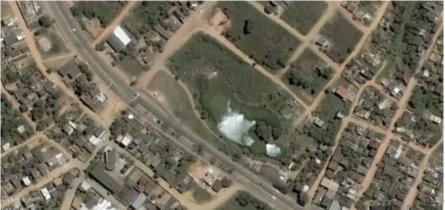
Figure 1. Aerial image of October 12th, 2005
The first, and therefore the oldest satellite image available in Google Earth Pro, corresponds to year 2005 (Figure 1), a period in which soil occupation, especially around the water body under analysis, was significantly lower than observed in later years. This place has a predominance of unpaved streets and expressive number of vacant lots; these associated factors, may contribute to less anthropogenic influence in the local watershed.
Braz. J. of Develop., Curitiba, v. 5, n. 7, p. 8464-8474 jul. 2019 ISSN 2525-8761
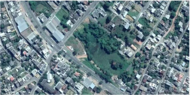
Figure 2. Aerial image of September 2nd, 2018
However, currently (Figure 2), it is the location of the bed at the edges of the highway, as well as a broad occupation of the ground throughout the area, including around the water body, with a number of dwellings and predominance of paved streets. In addition, it is possible to find the advanced stage of eutrophication to which a pond is subject, making possible – through the classification of historical images – its evolution. It is important to emphasize, however, the importance of considering the season, especially in the aspect of ciliary vegetation.
In short, the older images depict a greater comprehension of the water depth, indicating initial stages of eutrophication; less noticeable occupancy, noticeable by the presence of real estate under construction and vacant lots; besides the predominance of unpaved streets. Such aspects may contribute to less negative interference in the hydrographic basin and its related water resources and, in the same context, less waterproofing of the soil. The most recent images, on the other hand, depict a worrying scenario, which contributes to culminating in the advanced eutrophication of the subjected water body.
In this sense, the images in the historical series of Google Earth Pro provide important parameters for evaluating factors such as the evolution of eutrophication, especially in view of the water depth, less noticeable over the years. Thus, the analysis of the region suggests a disorderly growth and devoid of efficient urban and environmental planning.
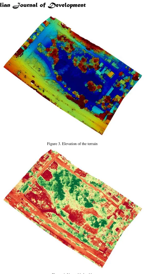
In addition to the regression in orbital images realized in Google Earth Pro, with the aid of the application DroneDeploy, the planning and the execution of the flight with drone were realized, resulting in three maps. The first one shows the elevation of the terrain (Figure
Braz. J. of Develop., Curitiba, v. 5, n. 7, p. 8464-8474 jul. 2019 ISSN 2525-8761 3), in which the dark shades of blue represent the deeper areas, while the shades of red and brown refer to the higher altitudes.
In this way, the lower areas are attributed to the interior of the lagoon, so that the flat areas are mostly associated with the region corresponding to the highway (green and yellow). On the other hand, high altitude areas are often associated with treetops still present on the site.
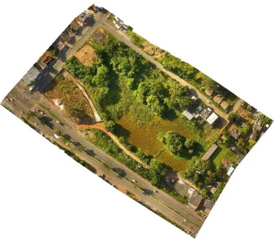
On the other hand, the vegetation health map (Figure 4) was generated from the application of the NDVI (Normalized Difference Vegetation Index) method, which emphasizes with greater intensity the regions that have greater interaction with the vegetation, and is therefore intensively applied in precision agriculture. This is because it allows highlighting the variation of the reflectance intensity of the radiation emitted by the plant species from the normalization of the infrared and near infrared frequencies.
Thus, the resulting map shows the presence of vegetation, especially in the northern portion of the lagoon, also evidencing the advanced stage of eutrophication inside the water body, as well as the removal of a significant portion of the ciliary vegetation – easily visible in the northwest region.
The flight planned with the drone resulted in numerous aerial images, which, compiled, allowed to generate an orthomosaic (Figure 5) that, despite small inconsistencies presented, was able to visually express various details of the region, besides consisting of an updated representation and high resolution digital.
Braz. J. of Develop., Curitiba, v. 5, n. 7, p. 8464-8474 jul. 2019 ISSN 2525-8761
Figure 3. Elevation of the terrain
Braz. J. of Develop., Curitiba, v. 5, n. 7, p. 8464-8474 jul. 2019 ISSN 2525-8761
Figure 5. Ortomosaic
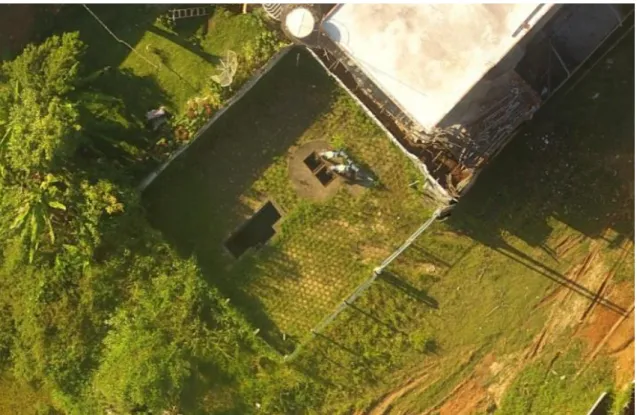
From this result, inside a property located on the banks of the lagoon, a water catchment structure was identified (Figure 6). Under this aspect, the identified illegal collection, in addition to its illicit nature, in view of not being granted by the competent agencies, contributes to burdening many aspects of the lagoon environment, reducing the already deficient flow of it.
Braz. J. of Develop., Curitiba, v. 5, n. 7, p. 8464-8474 jul. 2019 ISSN 2525-8761
Figure 6. Structure of clandestine uptake in the northeast portion of the orthomosaic (clipping)
4 DISCUSSION
In agreement with the other maps, the ortomosaic evidences the presence of constructions in areas very close to the lagoon, which are configured as Permanent Preservation Area. Additionally, in comparison to the most up-to-date orbital image available in Google Earth Pro – mainly due to the greater detail presented by the orthomosaic due, among other factors, to the low spatial resolution in which the photographs were obtained from the drone – it is possible to observe details previously noticed only in the field. In this context, it is possible to mention the construction of a wall delimiting an important region located in the northwest portion of the lagoon, besides the presence of a possible structure of water capture in the southeast region of the same. The first situation, mainly due to its proximity, can burden many of the characteristics of the aquatic body already compromised, while the second, if confirmed the catchment, is also capable of causing damages to the characteristics of the same, contributing to difficult its later recovery or rehabilitation. It is important to emphasize, however, the probable irregular character of the buildings, due to their proximity and/or non-exploitation of the water resource, associated to the fact that the SEMAG agents who accompanied the field visit did not identify the existence of projects that would make feasible structures and recognized their APP framework.
Braz. J. of Develop., Curitiba, v. 5, n. 7, p. 8464-8474 jul. 2019 ISSN 2525-8761 5 CONCLUSION
Thus, the products elaborated from the images obtained through the planned flight allowed to observe numerous aspects of the locality under study, culminating in a detailed analysis of the elevation, vegetation and other visual characteristics, such as use and occupation of the soil in the surroundings. In this way, the resulting maps became important means of assessing the environmental aspects and impacts of the area. This makes it possible to understand the local dynamics and provide support to support future decision-making – both regarding the depollution of the lagoon and refers to the framing of buildings and abstractions in disagreement with what is envisaged in the current environmental legislation.
REFERENCES
[1] Lannes, L. S. e Quintal, B., “Geoprocessing applied to spatial and temporal analyses of aquatic ecosystems as a tool in Science Education”, Vertices, v. 16, n. 2, p. 29-42, 2015. [2] Goudie, A., “Characterising the distribution and morphology of creeks and pans on salt marshes in England and Wales using Google Earth”, Estuarine, Coastal and Shelf Science, v. 129, p. 112-123, 2013.
[3] Peixoto, J. S., “Veículo Aéreo Não-Tripulado (VANT): Qualidade dos produtos e aplicabilidade em estudos ambientais”, Resultados preliminares, 2014.