HESSD
8, 9927–9959, 2011Hydrological heterogeneity in
Mediterranean reclaimed slopes
L. Merino-Mart´ın et al.
Title Page
Abstract Introduction
Conclusions References
Tables Figures
◭ ◮
◭ ◮
Back Close
Full Screen / Esc
Printer-friendly Version
Interactive Discussion
Discussion
P
a
per
|
Dis
cussion
P
a
per
|
Discussion
P
a
per
|
Discussio
n
P
a
per
|
Hydrol. Earth Syst. Sci. Discuss., 8, 9927–9959, 2011 www.hydrol-earth-syst-sci-discuss.net/8/9927/2011/ doi:10.5194/hessd-8-9927-2011
© Author(s) 2011. CC Attribution 3.0 License.
Hydrology and Earth System Sciences Discussions
This discussion paper is/has been under review for the journal Hydrology and Earth System Sciences (HESS). Please refer to the corresponding final paper in HESS if available.
Hydrological heterogeneity in
Mediterranean reclaimed slopes: runo
ff
and sediment yield at the patch and slope
scales along a gradient of overland flow
L. Merino-Mart´ın1, M. Moreno-de las Heras2, S. P ´erez-Domingo1, T. Espigares1, and J. M. Nicolau3
1
Departamento de Ecolog´ıa, Universidad de Alcal ´a, Alcal ´a de Henares, 28871 Madrid, Espa ˜na
2
Faculty of Engineering and Built Environment, University of Newcastle, Callaghan, NSW 2308, Australia
3
Departamento de Agricultura y Econom´ıa agraria, Escuela Polit ´ecnica Superior, Universidad de Zaragoza, Huesca, Espa ˜na
Received: 21 October 2011 – Accepted: 29 October 2011 – Published: 14 November 2011
Correspondence to: L. Merino-Mart´ın ([email protected])
HESSD
8, 9927–9959, 2011Hydrological heterogeneity in
Mediterranean reclaimed slopes
L. Merino-Mart´ın et al.
Title Page
Abstract Introduction
Conclusions References
Tables Figures
◭ ◮
◭ ◮
Back Close
Full Screen / Esc
Printer-friendly Version
Interactive Discussion
Discussion
P
a
per
|
Dis
cussion
P
a
per
|
Discussion
P
a
per
|
Discussio
n
P
a
per
|
Abstract
Hydrological heterogeneity is recognized as a fundamental ecosystem attribute in dry-lands controlling the flux of water and energy through dry-landscapes. Therefore, mosaics
of runoffand sediment sinks and source patches are frequently identified in these dry
environments. There is a remarkable scarcity of studies about hydrological spatial
5
heterogeneity in restored slopes, where ecological succession and overland flow are interacting. We conducted a field research to study the hydrological role of patches and slopes along an overland flow gradient in three reclaimed slopes coming from mining
reclamation in a Mediterranean-continental climate. We found that runoff generation
and routing in non-rilled slopes showed a pattern of source and sink areas of runoff.
10
Such hydrological microenvironments were associated to seven vegetation patches (characterized by plant community types and cover). Two types of sink patches were
identified: shrubGenista scorpiuspatches could be considered as a “deep sink”, while
patches where the graminoidsBrachypodium retusumand Lolium perenne dominate
were classified as “surface sinks” or “runoffsplays”. A variety of source patches were
15
also identified spanning from “extreme sources” (Medicago sativapatches; equivalent
to bare soil) to “poor sources” (areas scattered by dwarf-shrubs ofThymus vulgarisor
herbaceous tussocks ofDactylis glomerata). Finally, we identified the volume of
over-land flow routing along the slope as a controlling major factor of hydrological diversity: when overland flow increases at the slope scale hydrological diversity diminishes.
20
1 Introduction
Spatial heterogeneity is a fundamental ecosystem attribute in drylands, controlling the flux of resources and energy through landscapes (Noy-Meir, 1973; Schlesinger et al., 1990). Indeed, water-limited landscapes are generally arranged in a mosaic of patches
with diverse hydrological role, where surface fluxes of water runoff and sediments
HESSD
8, 9927–9959, 2011Hydrological heterogeneity in
Mediterranean reclaimed slopes
L. Merino-Mart´ın et al.
Title Page
Abstract Introduction
Conclusions References
Tables Figures
◭ ◮
◭ ◮
Back Close
Full Screen / Esc
Printer-friendly Version
Interactive Discussion
Discussion
P
a
per
|
Dis
cussion
P
a
per
|
Discussion
P
a
per
|
Discussio
n
P
a
per
|
interact with vegetation dynamics (Lavee et al., 1998; Puigdef ´abregas, 2005). The Trigger-Transfer-Reserve-Pulse (hereafter TTRP) conceptual model developed by Lud-wig et al. (1997, 2005) represents a useful framework for the understanding of these systems. This approach suggests that these ecosystems are structured as a mosaic of densely vegetated patches, with resource-sink hydrological role, interspaced within
5
a bare soil or scarcely vegetated component, with resource-source hydrological role.
The transfer of water runoffand sediments from the bare source areas to vegetated
patches (i.e. sinks) maximizes the use of resources, producing pulses of vegetation growth, which increase the ability of vegetation patches to capture surface resource fluxes and hence, enhance water and soil conservation at the landscape level.
10
Several studies have highlighted the operation of coupled eco-hydrological pro-cesses described by the TTRP conceptual framework in many semiarid and arid ecosystems throughout the world, including Niger (Seghieri et al., 1997; Bromley et al., 1997), Jordan (White, 1969), Australia (Dunkerley and Brown, 1995), USA (Reid et al., 1999) and Spain (Calvo-Cases et al., 2003). Further work refined the principles of
15
this approach, explaining that the sink-source hydrological role of vegetation patches does not only depend on vegetation density, but also on the specific traits of the domi-nant plant species growing in them (Bochet et al., 2006; Garcia-Estringana et al., 2010; Vasquez-Mendez et al., 2010).
The effects of disturbance on these resource-conserving natural ecosystems are
20
well known: rises in runoff generation and soil erosion, frequently associated to the
development of rill or gully networks (Davenport et al., 1998; Ludwig and Tongway, 2000; Wilcox et al., 2003). Under these conditions, vegetation patches are not able
to capture water and sediments efficiently, causing a significant loss of resources at
the landscape scale. These losses reduce vegetation growth and, in consequence,
25
HESSD
8, 9927–9959, 2011Hydrological heterogeneity in
Mediterranean reclaimed slopes
L. Merino-Mart´ın et al.
Title Page
Abstract Introduction
Conclusions References
Tables Figures
◭ ◮
◭ ◮
Back Close
Full Screen / Esc
Printer-friendly Version
Interactive Discussion
Discussion
P
a
per
|
Dis
cussion
P
a
per
|
Discussion
P
a
per
|
Discussio
n
P
a
per
|
high, favoured by structurally poor soils, rough topographical designs, and occasionally,
the presence of runoffcontributing areas (e.g. steep berms, tracks, etc.) located at the
top of slopes (Moreno-de las Heras et al., 2008; Hancock and Willgoose, 2004). When the amount of overland flow is high, intense soil erosion processes develop, rill erosion
being the most significant phenomenon. Rill networks drain runoff away from slopes
5
efficiently, reducing water infiltration, thus increasing the water deficit (Moreno-de las
Heras et al., 2010). As a result, vegetation dynamics is affected, constraining seed
ger-mination, plant establishment and development, and seed production (Espigares et al., 2011). These mechanisms drive the reclaimed ecosystem towards a highly degraded state, in which a very costly intervention is required to facilitate vegetation recovery
10
(Nicolau, 2003; Merino-Mart´ın et al., 2011).
To date, the study of the interactions between the dynamics of overland flow and
vegetation has focused on degradation processes affecting both natural and reclaimed
semiarid environments. Notably lacking are studies that focus on the opposite
ecosys-tem recovery phenomenon. Reclaimed mining environments offer excellent
opportuni-15
ties for the elucidation of the structural and functional dynamics of ecological systems, where soils and vegetation are in general very simple, so that plant communities and hydrological processes represent early stages of ecosystem organization (Aronson et
al., 1993). In this study, we analyze hydrological processes (i.e. runoffgeneration and
routing and sediment yield) acting at both the patch and slope scales in
Mediterranean-20
dry reclaimed mining slopes with sparse vegetation and with absent or poorly devel-oped (i.e. spatially discontinuous) rill networks. Previous work carried out in the same study area (Moreno-de las Heras et al., 2009, 2010) indicated that under these con-ditions overland flow is not routed by rill networks, running mostly as sheet flow over the surface, so the vegetation is able to establish successfully on slopes, promoting a
25
HESSD
8, 9927–9959, 2011Hydrological heterogeneity in
Mediterranean reclaimed slopes
L. Merino-Mart´ın et al.
Title Page
Abstract Introduction
Conclusions References
Tables Figures
◭ ◮
◭ ◮
Back Close
Full Screen / Esc
Printer-friendly Version
Interactive Discussion
Discussion
P
a
per
|
Dis
cussion
P
a
per
|
Discussion
P
a
per
|
Discussio
n
P
a
per
|
of this hydrological heterogeneity with the amount of overland flow routed along the slopes.
We state as a fundamental assumption that the different vegetation patches
devel-oped in these Mediterranean-dry reclaimed slope systems have a diverse hydrological role that can be functionally categorized as sources or sinks of resources, in
accor-5
dance with the TTRP conceptual framework (Ludwig et al., 1997, 2005). Furthermore, we hypothesize that the hydrological heterogeneity of these reclaimed ecosystems is modulated by the amount of overland flow running at the slope scale. This overland flow will increase the complexity of surface hydrological role as it decreases, as that
would indicate efficient runoffredistribution across the slope between different patches
10
fulfilling different hydrological roles. In addition, we hypothesize that we can find two
mosaic-generating processes along the overland flow gradient: mosaics driven by
differential erosion (i.e. Wainwright et al., 2002), where plant cover plays a passive
role, and mosaics driven by vegetation (i.e. Puigdef ´abregas, 2005), where vegetated patches become hot-spots of soil and vegetation change.
15
2 Methods
2.1 Study area
The study site is located within the Utrillas coalfield (∼1100 m a.s.l. above sea level)
in the Iberian Mountain Chain (Spain). This work was carried out in three reclaimed mining slopes located atEl Moral spoil bank (40◦47′50′′N, 0◦50′26′′W) that were
se-20
lected to span a gradient of overland flow. The climate is Mediterranean-Continental
with mean annual temperature of 14◦C (ranging from a minimum mean daily
temper-ature of 6.7◦C in December and a maximum mean daily temperature 23.1◦C in July),
with air frost period between October and April. The local moisture regime can be classified as dry Mediterranean (Papadakis, 1966) with mean annual precipitation of
25
HESSD
8, 9927–9959, 2011Hydrological heterogeneity in
Mediterranean reclaimed slopes
L. Merino-Mart´ın et al.
Title Page
Abstract Introduction
Conclusions References
Tables Figures
◭ ◮
◭ ◮
Back Close
Full Screen / Esc
Printer-friendly Version
Interactive Discussion
Discussion
P
a
per
|
Dis
cussion
P
a
per
|
Discussion
P
a
per
|
Discussio
n
P
a
per
|
of 759 mm, yielding a hydrological deficit of 292 mm running from June to October. The
mean number of annual rainfall events in the area is∼50, with some convective
rain-storms occurring especially in summer, characterized by high rainfall intensities of up to 100 mm in 24 h (Pe ˜na et al., 2002).
The slopes were built between 1987 and 1988 by theMinas y Ferrocarril de Utrillas
5
S.A.mining company, with between 18◦and 20◦inclinations and a layer of 100–250 cm
of a clay-loam overburden substratum free of major physicochemical constraints (see Table 1 for a detailed description of slopes). Revegetation of slopes was implemented
after cross-slope ploughing by sowing a mixture of perennial grasses (Festuca rubra,
Festuca arundinacea,Poa pratensisandLolium perenne) and leguminous herbs (
Med-10
icago sativa and Onobrychis viciifolia). Although the slopes were restored using the
same general procedures, they differed in their subsequent evolution (i.e. rilling,
veg-etation development), due to differences in their geomorphological design, chiefly in
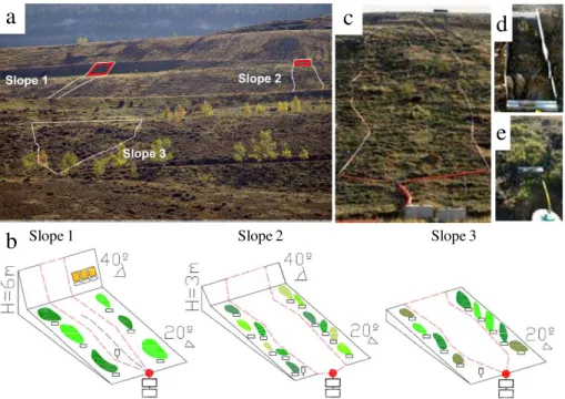
the upper part (Moreno-de las Heras et al., 2008, 2009). Indeed, a 40◦ steep berm
(barely covered; <3%) integrated at the top of some slopes (Fig. 1a and b) acts as a
15
water-contributing area, generating important amounts of overland flow and promoting rill erosion processes. This situation gave us the opportunity to select three reclaimed scenarios subjected to a variable amount of overland flow routed along the slopes since
their construction. Although there are no significant differences in soil traits between
slopes (Table 1), differences in the size of the up-slope water contributing area and
20
its associated erosion processes (discontinuous rilling on slope 1 and sheet flow on
slopes 2 and 3) have promoted large differences in vegetation development.
2.2 Hydrological measurements
Runoff and sediment yield at slope and patch scales were monitored on the three
experimental slopes from October 2007 to December 2008. The hydrological year in
25
HESSD
8, 9927–9959, 2011Hydrological heterogeneity in
Mediterranean reclaimed slopes
L. Merino-Mart´ın et al.
Title Page
Abstract Introduction
Conclusions References
Tables Figures
◭ ◮
◭ ◮
Back Close
Full Screen / Esc
Printer-friendly Version
Interactive Discussion
Discussion
P
a
per
|
Dis
cussion
P
a
per
|
Discussion
P
a
per
|
Discussio
n
P
a
per
|
At the slope scale, naturally delimited catchments (unbounded plots) were selected
(Fig. 1a–c). Therefore, the area of the slope-scale plots differed between the three
slopes (see Table 1). At the foot of each slope catchment two plastic collectors were
installed and a central cemented outlet fed into these collectors. From the outlet, runoff
was guided through a pipe into two 200-l storage tanks connected by a ten-slot runoff
5
divider.
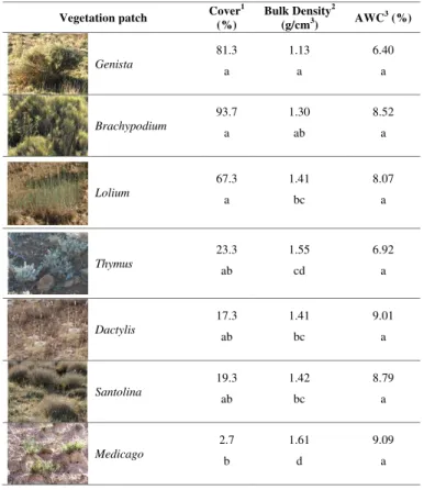
At the patch scale, a variable number of Gerlach plots were installed, encompassing
the different vegetation patches present in slopes. In total, we found seven different
types of vegetation patches dominated by different plant species (see Table 2 for a
detailed description of vegetation cover and soil structural properties of patches):
scat-10
tered clumps of legumes (M. sativa) and grasses (Dactylis glomerata) in a matrix of
bare soil, scattered dwarf shrubs (Santolina chamaecyparissus andThymus vulgaris)
in a matrix of bare soil, and finally, patches densely covered by grasses (L. perenne
and Brachypodium retusum) and shrubs (Genista scorpius). Three unbounded
Ger-lach plots 0.5 m wide (connected to 100 l runoff storage drums) per cover type were
15
established in each slope (Fig. 1e). Catchment areas of Gerlach plots were visually
delimitated on the basis of surface microtopography, and ranged from 1 to 16 m2. For
M. sativa patches, bounded 3 m long Gerlach plots were used (0.5 m wide; Fig. 1d),
since the high runoffvolumes produced by these patches – located on the steep berm
integrated at the top of slopes – compromised the operability of the experimental
de-20
sign. A 3 m length Gerlach plot was selected for these patches according to previous results obtained in the study site, which showed a low scale-dependency of
hydro-logical responses in plots of this length (Moreno-de las Heras et al., 2010). Runoff
collected from plots was measured after each runoff event (runoff-producing events
occurring within a 24 h period were considered the same event). Runoff was
deter-25
mined by measuring water level in the container and calculating final volume using
the relevant geometric equations. During the study period, no runoffevent exceeded
the storage capacity of tanks and drums, nor were there any significant losses from
HESSD
8, 9927–9959, 2011Hydrological heterogeneity in
Mediterranean reclaimed slopes
L. Merino-Mart´ın et al.
Title Page
Abstract Introduction
Conclusions References
Tables Figures
◭ ◮
◭ ◮
Back Close
Full Screen / Esc
Printer-friendly Version
Interactive Discussion
Discussion
P
a
per
|
Dis
cussion
P
a
per
|
Discussion
P
a
per
|
Discussio
n
P
a
per
|
1 l sample was taken by filling a 1 l plastic bottle from the bottom up in order to obtain an integrated sample. Sediment concentrations were determined by oven-drying (at
105◦C) the collected runoffsample until constant weight was achieved. Precipitation
amount and characteristics were measured using an automatic recording rain gauge
(GroWeather, Davis®) located about 500 m from experimental slopes. Total
precipi-5
tation was also recorded using three pluviometers, each located on one experimental slope. According to pluviometer data, spatial variations in precipitation during the study period were negligible.
2.3 Topographic and microtopographic measurements
A total station was used to carry out a topographical survey by tacheometry, defining
10
the surface of the vegetation patches. Filling points and break lines were defined in order to determine slope topography. In each slope, the presence of micro-topographic
structures and species vegetation cover was registered in 35 50×50 cm plots (seven
plots regularly distributed in five transects along the slope).
2.4 Soil moisture measurements
15
To test differences in soil water content between patches, TDR (Time Domain
Reflec-tometry) sensors were installed horizontally at 25 cm into the soil in four replicates of
each vegetation patch. A TDR cable tester (Tektronix® 1502C), was used to collect
the data, following the methodology proposed by Cassel et al. (1994), with an accu-racy of 94 % in soil moisture determination. Soil water content data were collected
20
within 5 days after each precipitation event.
2.5 Data analyses
Differences in runoff and sediment yield at the slope scale were analysed using
HESSD
8, 9927–9959, 2011Hydrological heterogeneity in
Mediterranean reclaimed slopes
L. Merino-Mart´ın et al.
Title Page
Abstract Introduction
Conclusions References
Tables Figures
◭ ◮
◭ ◮
Back Close
Full Screen / Esc
Printer-friendly Version
Interactive Discussion
Discussion
P
a
per
|
Dis
cussion
P
a
per
|
Discussion
P
a
per
|
Discussio
n
P
a
per
|
sediment yield and soil water content at the patch scale were analysed using non para-metric tests for repeated measures (Friedman test and post-hoc Wilcoxon-Nemenyi-McDonald-Thompson test; Hollander and Wolfe, 1999). In order to analyze the
influ-ence of rainfall characteristics on the hydrological role of the different patches, we used
linear regressions to relate runoffand sediment yield with rainfall properties (depth and
5
intensity). Runoff, soil moisture and sediment yield data were used to perform a cluster
analysis (Tryon, 1939) to separate out groups of patches with homogeneous hydrolog-ical role. The linkage rule employed was Ward’s method and City-block (Manhattan) as distances measures. We used Chi-Square test to analyze if there were significant relationships between vegetation patch hydrological behaviours and micro-topographic
10
structures.
We estimated the “hydrological diversity” of each slope by computing the Shannon diversity index, for which we included the hydrological groups obtained from the clus-ter analysis as species. This diversity index is dependent of both the richness and abundance (vegetation patch) of each hydrological group.
15
Statistical analyses were performed using STATISTICA (Statsoft, 2001). Post-hoc
Wilcoxon-Nemenyi-McDonald-Thompson tests were performed with the “coin” and “multcomp” packages of the R program (R Development Core Team, 2009) using the code of “Tal Galili”, published on r-statistics.com (http://www.r-statistics.com/2010/02/ post-hoc-analysis-for-friedmans-test-r-code).
20
3 Results
3.1 Rainfall characteristics
A total of 74 rainfall events were registered during the study period, accounting for a total rainfall of 703 mm. During the 2007 hydrological year a total of 550.7 mm were registered, which was above the historical average of 466.2 mm reported by Pe ˜na et
25
HESSD
8, 9927–9959, 2011Hydrological heterogeneity in
Mediterranean reclaimed slopes
L. Merino-Mart´ın et al.
Title Page
Abstract Introduction
Conclusions References
Tables Figures
◭ ◮
◭ ◮
Back Close
Full Screen / Esc
Printer-friendly Version
Interactive Discussion
Discussion
P
a
per
|
Dis
cussion
P
a
per
|
Discussion
P
a
per
|
Discussio
n
P
a
per
|
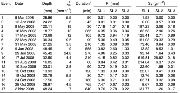
produced runoffat the slope scale. Characteristics of the runoff-producing rainfall and
hydrological responses to these events are shown in Table 3. Average duration and
depth of runoff-producing events was 233.8 min and 36.7 mm, respectively. Intensity of
maximum single event varied from 2.5 mm h−1to 24.8 mm h−1.
3.2 Runoff, erosion and soil moisture at the patch scale
5
Total runoff, runoffcoefficients and sediment yield differed significantly between cover
types (p <0.0001, Friedman test, Fig. 2). Multiple comparisons between vegetation
patches shown in Fig. 2 suggest that there is a gradient with two extremes: one patch
(Genista) showing lower runoffand sediment production and higher soil moisture and
another patch (Medicago) with higher runoffand sediment production rates and lower
10
soil water content.
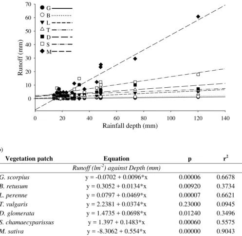
3.3 Hydrological role of vegetation patches vs. rainfall characteristics
Significant linear relationships between runoffand rainfall depth within each patch were
obtained, showing a variable effect of the amount of rain on runoff(Fig. 3a) depending
on patch. The slope of the regression equation can be used as a parameter to
mea-15
sure the effect of the different vegetation patches on hydrological processes (Fig. 3b).
In accordance with runoffyield results, the lowest slope of the regression equation
cor-responded to the vegetation patch with lowest runoff rates and sediment production
(Genista patches), and the highest slope of the regression to the Medicago patches
(which had highest runoffand sediment yield rates).
20
3.4 Hydrological groups
Classification of vegetation/cover patches based on hydrological properties (runoff,
runoffcoefficient and soil moisture) using cluster analysis resulted in 4 groups (Fig. 4).
Together with previous results, we related the resulting groups to four main
hydrolog-ical roles. One group (runoffsinks) included three patches (Genista, Brachypodium,
HESSD
8, 9927–9959, 2011Hydrological heterogeneity in
Mediterranean reclaimed slopes
L. Merino-Mart´ın et al.
Title Page
Abstract Introduction
Conclusions References
Tables Figures
◭ ◮
◭ ◮
Back Close
Full Screen / Esc
Printer-friendly Version
Interactive Discussion
Discussion
P
a
per
|
Dis
cussion
P
a
per
|
Discussion
P
a
per
|
Discussio
n
P
a
per
|
Lolium) with lower runoffand sediment production rates and higher soil water content
(Fig. 2). It was possible to distinguish two kind of sinks within this group; deep sinks (G)
and surface sinks (B, L), which appeared slightly different in the cluster classification
dendrogram. In contrast with this sink group there were two groups with the highest
amounts of runoffand sediment yield (SantolinaandMedicago), which were assigned
5
to moderate and extreme runoffsources, respectively. Between these contrasting roles,
a fourth group was found (low runoffresponse) which included two patches (Dactylis
andThymus) that played the role of poor runoffsources.
Runoffand sediment yield were only recorded for rainfall events that delivered runoff
at the foot of slopes (slope-scale runoffproducing events). In addition, we used
un-10
bounded gerlach plots to describe actual hydrological role of these patches; this ap-proach assumes the fact that some high-intensity precipitation events may have con-nected a greater surface than the estimated catchment areas for each patch. These
two design constraints explain the counterintuitive result of classifying as a runoffsink
a surface patch in which some (though very low) amounts of runoffand erosion were
15
recorded.
3.5 Micro-topographic forms
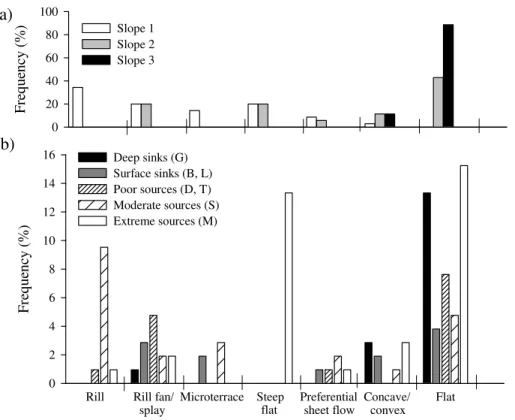
We found seven micro-topographic forms in the three slopes under study: flat areas, steep flat (flat forms with gradient of 40 %), concave/convex, preferential sheet-flow,
rills, rill fans/splays (where a rill interrupts) and runoffsplays (deposition areas formed
20
by water accumulation in micro-terraces built during restoration practices). In general, slopes 1 and 2 had many of these micro-topographic forms while slope 3 was mainly dominated by flat areas (Fig. 5a).
There was a significant relationship between the hydrological groups and the
micro-topographic structures found on the three slopes (Chi-Square=75.59; df=27;
25
HESSD
8, 9927–9959, 2011Hydrological heterogeneity in
Mediterranean reclaimed slopes
L. Merino-Mart´ın et al.
Title Page
Abstract Introduction
Conclusions References
Tables Figures
◭ ◮
◭ ◮
Back Close
Full Screen / Esc
Printer-friendly Version
Interactive Discussion
Discussion
P
a
per
|
Dis
cussion
P
a
per
|
Discussion
P
a
per
|
Discussio
n
P
a
per
|
contrast, extreme sources appeared associated with steep flat micro-topographic forms
and deep sinks (G) appeared more frequently in flat forms.
3.6 Hydrological heterogeneity at the slope scale
Runoff coefficient and sediment yield differed significantly between the three slopes
(p <0.0001, Kruskal-Wallis test, Fig. 6a and b), showing a gradient of soil erosion
5
from slope 1 to slope 3. Significant linear relationships were found between runoffand
rainfall depth at the slope scale, differences in the equation slope suggest a different
behavior for each of the three slopes (Fig. 6c).
When the abundance of each of the four hydrological groups of patches obtained from the cluster analysis in the three slopes were compared (Fig. 6d), extreme sources
10
were found to be absent in slope 3, which was characterized by a fairly homogeneous abundance of moderate and poor sources and sinks. On the contrary, slope 1 was characterized by a dichotomous hydrological role (with extreme and moderate sources and sinks) but without poor source patches, which were most abundant in slope 2. Hydrological diversity increased as overland flow decreased (Fig. 6e).
15
4 Discussion
Our results showed that patterns of runoff generation, infiltration and routing in
re-claimed slopes are highly dependent on the patch covering the soil, controlling the
final role as a runoffsource or sink. The cluster analysis applied to field data of runoff
and erosion rates and soil water content in the seven patches allowed us to identify
20
four “micro-environments” with different hydrological role: (1) sinks (Genista,
Brachy-podium, Lolium), (2) poor sources (Dactylis, Thymus), (3) moderate sources (
San-tolina) and (4) extreme sources (Medicago). These findings are supported by
compar-isons of runoff, sediment yield rates and soil water content, and by the identification of
different hydrological responses of patches to rainfall characteristics.
HESSD
8, 9927–9959, 2011Hydrological heterogeneity in
Mediterranean reclaimed slopes
L. Merino-Mart´ın et al.
Title Page
Abstract Introduction
Conclusions References
Tables Figures
◭ ◮
◭ ◮
Back Close
Full Screen / Esc
Printer-friendly Version
Interactive Discussion
Discussion
P
a
per
|
Dis
cussion
P
a
per
|
Discussion
P
a
per
|
Discussio
n
P
a
per
|
Our results suggest that the general model developed for semi-arid areas (TTRP) de-scribing two main types of hydrological microenvironments (sources and sinks) should be delved into in the case of constructed slopes. Bare patches between plants –
char-acterised by a poor soil structure and a low infiltration capacity – act as runoff
gen-erating areas; while areas under plant clumps function as runoffsinks, where organic
5
matter contents are higher, favouring soil aggregation and soil faunal activity, hence increasing macro-porosity and infiltration rates (Calvo-Cases et al., 2003; Ludwig and Tongway, 1995; S ´anchez and Puigdefabregas, 1994). In our study, we have also iden-tified the type of plant assemblages that play either role, as well as the intensity of that role in each case.
10
In the studied slopes, sinks were associated with the production of very low amounts
of runoffand sediments collected down slope from the patch. Furthermore, these low
runoffand sediment yield rates were relatively constant in these patches, even under
high precipitation or intense rainfall conditions. These patches are soil surface areas
densely covered by grasses (L. perenne, B. retusum) or shrubs with a dense
herba-15
ceous understory (G. scorpius).B. retusumis a common species following disturbance
in Mediterranean environments (Bautista et al., 1996; Cerd `a, 1998). It has been de-scribed as a good soil protector, with a high erosion control capacity (De Baets et al., 2007) thanks to a dense root system and the consolidation of soil aggregates (Cerd `a,
1998). We found that runoffand erosion rates where low for B. retusum, contrasting
20
with the low amounts of soil water content after rainfall at 25 cm, which could
sug-gest that this species is highly efficient in obstructing runoff and sediments although
it is not so efficient infiltrating water in depth. In fact, results and field observations
showedB. retusumclumps splaying rather than retaining the water and sediment flow.
Ryegrass (L. perenne) is not a characteristic species of Mediterranean degraded
en-25
vironments; it was introduced during revegetation practices. The effects of ryegrass
in reducing runoff and erosion rates have been broadly described (Zhou and
Shang-guan, 2007). It has been found that canopies of ryegrass usually contribute to runoff
HESSD
8, 9927–9959, 2011Hydrological heterogeneity in
Mediterranean reclaimed slopes
L. Merino-Mart´ın et al.
Title Page
Abstract Introduction
Conclusions References
Tables Figures
◭ ◮
◭ ◮
Back Close
Full Screen / Esc
Printer-friendly Version
Interactive Discussion
Discussion
P
a
per
|
Dis
cussion
P
a
per
|
Discussion
P
a
per
|
Discussio
n
P
a
per
|
decrease in sediment yields (Zhou and Shangguan, 2008). We also found that this
patch was highly efficient in obstructing runoffand sediments, although it is the sink
with the highest runoffand erosion rates and the most precipitation-dependent
hydro-logical behaviour.Genistapatches had the significantly lowest runoffand erosion rates
and highest soil water content. Soil moisture content after rainfall, which is a good
5
indicator of a runoffsink role, suggests that this patch is not only efficient in obstructing
runoffand sediments; it also incorporates water at depth. We found that the soil
char-acteristics ofG. scorpiusunderstorey are significantly different, with lower bulk density
and surface strength. The deeply infiltrated water is easily conserved against
evapo-ration and used byG. scorpius and associated plants during dry periods. Molinillo et
10
al. (1997) found also that under a denseG. scorpius cover, both runoffand sediment
yield are strongly controlled.
Briefly, our results emphasize the presence of a variety of sink roles dependent on
plant community characteristics; G. scorpius patch could be considered as a “deep
sink”, whileB. retusum andL. perennecould be described as “surface sinks” or “runoff
15
splays”.
Our results suggest an interrelation between micro-topographic structures and veg-etation patches present on these microstructures. The three selected slopes rep-resent a gradient of overland flow from discontinuous rilling to very low amounts of
runoffrouting as sheet flow along the slopes. This gradient generated different
micro-20
topographies through soil erosion: rills and rill-fans in the slope with highest runoff
volumes (slope 1), splays when runoff volumes decreased (slope 2), and absence of
micro-topographic structures in the slope with low runoffvolumes (slope 3). These
re-sults are supported by the fact that two of the three types of sink patches described
(LoliumandBrachypodium) are related to microterraces and splays forms (field
obser-25
vations relatedLolium to rill fans andBrachypodiumto splays). Thus, we suggest that
the proliferation of these cover types was related, in the early stages of succession, to
the existence of these micro-structures. In fact, the characteristic speciesL. perenne
HESSD
8, 9927–9959, 2011Hydrological heterogeneity in
Mediterranean reclaimed slopes
L. Merino-Mart´ın et al.
Title Page
Abstract Introduction
Conclusions References
Tables Figures
◭ ◮
◭ ◮
Back Close
Full Screen / Esc
Printer-friendly Version
Interactive Discussion
Discussion
P
a
per
|
Dis
cussion
P
a
per
|
Discussion
P
a
per
|
Discussio
n
P
a
per
|
conditions generated by rill fans. On the other hand, B. retusum, which is a pioneer
species typical in degraded environments, would have colonized only the splays where it can persist. These findings are in accordance with Wainwright et al. (2002), who worked in flows with a discontinuous pattern, with alternating areas of channelization and deposition, and found that rill fans (they called these areas “beads”) were areas
5
with higher concentrations of nutrient, water and seed resources, finding these sites favourable for the growth of “islands of fertility” (Garner and Steinberger, 1989). A
dif-ferent situation is found in slope 3, where different runoff volumes have not eroded
the surface differentially and did not generate different micro-structures. Therefore,
we suggest that the colonization ofGenista in this slope is independent of the
gen-10
eration of favourable hydric microenvironments and their initial spatial distribution was conditioned by other abiotic and biotic factors. Thus, we can say that we found the two mosaic-generating processes named by Puigdef ´abregas (1999): mosaics driven
by differential erosion, where plant cover plays a passive role (slopes 1 and 2), and
mosaics resulting from “nucleation” processes (slope 3), where vegetated patches
be-15
come hot-spots of soil and vegetation change. Besides, we found that the gradient of overland flow routing along the slope influences these mosaic generation processes, shifting the driving force of mosaic generation towards an abiotic control under higher overland flow volumes.
In contrast with the sink roles described,MedicagoandSantolinapatches played an
20
obvious role as sources.Medicagopatches had the highest runoffrates and sediment
yield (considered extreme sources of runoff), followed by Santolina (moderate runoff
source). Medicago patches have a high bare soil cover (vegetation cover<3 %) while
Santolina patches include vegetated interpatches of scattered dwarf-shrubs
(vegeta-tion cover ≈20 %). Similar runoff and erosion rates to those obtained for Medicago
25
plots were obtained in bare soil by other authors (Cerd `a, 1997).
Within these contrasting hydrological roles we found two patches (Thymusand
Dac-tilys) which belong to vegetated inter-patches areas with cover ranging from 15 to
HESSD
8, 9927–9959, 2011Hydrological heterogeneity in
Mediterranean reclaimed slopes
L. Merino-Mart´ın et al.
Title Page
Abstract Introduction
Conclusions References
Tables Figures
◭ ◮
◭ ◮
Back Close
Full Screen / Esc
Printer-friendly Version
Interactive Discussion
Discussion
P
a
per
|
Dis
cussion
P
a
per
|
Discussion
P
a
per
|
Discussio
n
P
a
per
|
orchardgrass (D. glomerata). Both species are characteristic of semi-natural
Mediter-ranean environments. T. vulgaris develops on relatively erodible soils (Cerd `a, 1998),
whereas the growth ofD. glomerata has been described as good for erosion control,
although not as good asL. perenne(Gokbulak, 2003). However, they play a similar
hy-drological role which could be explained by differences in cover (23.33 % forT. vulgaris
5
and 17.33 % forD. glomerata).
Our results confirm that not only plant cover plays a main role for hydrological
con-trol in inter-patch areas, but plant morphology is also important. AlthoughSantolina
patches had a similar vegetation cover to those ofThymus orDactylis, they have
sig-nificant higher erosion rates. This result agrees with those of Bochet et al. (2006), who
10
found that rates of soil loss and runoffreduction varied strongly between three different
Mediterranean species because of different plant morphology and features.
Our experimental design, which included three slopes subjected to the influence of
a range of upslope runoffgeneration, allowed us to evaluate the effect of overland flow
on hydrological heterogeneity. The particular influence of runon (in this case runoff
15
contributions from upslope structures) on the ecohydrology of these constructed sys-tems must be taken into account. Moreno-de las Heras et al. (2009) reported a trend towards hydrological and ecological simplification when run-on cause the development of dense rill networks. Our results, referred to non-concentrated overland flow regimes, illustrate how when the amount of overland flow routing along slopes decreases,
hy-20
drological heterogeneity increases. We obtained the highest runoffand erosion rates
for slope 1, which developed some discontinuous rills, finding significant differences
with the other two non-rilled slopes. Moreover, we obtained very different rainfall-runoff
relationships for the set of experimental slopes, with slope 1 being highly dependent on rainfall volume, which together with the previous result, suggests a greater
hydro-25
logical connectivity of this slope compared with slopes 2 and 3. In fact, these results can be explained as a consequence of the development of discontinuous rills, which
increase runoffconnectivity and consequently, runoffand soil erosion rates (Nicolau,
HESSD
8, 9927–9959, 2011Hydrological heterogeneity in
Mediterranean reclaimed slopes
L. Merino-Mart´ın et al.
Title Page
Abstract Introduction
Conclusions References
Tables Figures
◭ ◮
◭ ◮
Back Close
Full Screen / Esc
Printer-friendly Version
Interactive Discussion
Discussion
P
a
per
|
Dis
cussion
P
a
per
|
Discussion
P
a
per
|
Discussio
n
P
a
per
|
The proportion of runoffsources decreased along the overland flow gradient
repre-sented by the slopes, the extreme sources being absent in slope 3, with the lowest
runoffcoefficient. Moreover, this slope presented the highest values of “hydrological
diversity” (an index influenced by both the richness and proportion of each
hydrolog-ical group). This slope hosts conditions for the development of a very efficient sink,
5
clumps ofG. scorpiuswith a dense understorey of grasses and forbs. This sink shows
a remarkable capacity for overland flow interception as well as for increasing soil wa-ter content at 25 cm depth. These properties facilitate the development of vegetation and the spread of plant cover, leading the reclaimed ecosystem towards more com-plex states. Thus, we can say that as upslope generation of overland flow becomes
10
less important in theses slopes, hydrological heterogeneity increases and is driven by
vegetation, promoting a variety of sinks and low runoffproduction areas. Moreover,
hy-drological connectivity decreases and water availability for plants increases, reinforcing the trend towards the biological control of the hydrological processes.
Our experimental design also allows us to discuss these results under the
perspec-15
tive of the temporal evolution of sink-source patterns as ecological succession pro-ceeds in these reclaimed ecosystems. This phenomenon has been scarcely analysed: most previous studies depict hydrological heterogeneity for stable systems throughout the world where sources and sinks are coupled under a dynamic equilibrium state (Lud-wig et al., 1997, 2005), or address the stability of coupled systems under several types
20
of disturbances, mainly fires and overgrazing, which reduce vegetation cover, and thus
runoffobstruction, increasing runoffand erosion rates (Wilcox et al., 2003; McIvor et
al., 1995; Scanlan et al., 1996). Our research describes the variation of the sink-source pattern in a gradient of ecological recovery after slope reclamation. Thus, when
ups-lope runoffgeneration decreases and the vegetation is able to reach a higher level of
25
complexity, a new type of sink develops: theGenista scorpiusdeep sink, with a dense
HESSD
8, 9927–9959, 2011Hydrological heterogeneity in
Mediterranean reclaimed slopes
L. Merino-Mart´ın et al.
Title Page
Abstract Introduction
Conclusions References
Tables Figures
◭ ◮
◭ ◮
Back Close
Full Screen / Esc
Printer-friendly Version
Interactive Discussion
Discussion
P
a
per
|
Dis
cussion
P
a
per
|
Discussion
P
a
per
|
Discussio
n
P
a
per
|
the ecology of these slopes, although more research is needed to investigate whether the water accumulated in the patches provides a pulse for vegetation growth.
5 Conclusions
Runoffgeneration and routing in constructed slopes that have not developed
contin-uous rill networks revealed a pattern of source and sink areas. Such hydrological
5
microenvironments were associated to seven patches (characterized by different plant
communities and cover). Two types of sink patches were identified: G. scorpius
com-munity, considered as a “deep sink”;B. retusumandL. perennedescribed as “surface
sinks”. Surface sinks were related to previous micro-structures while the deep sinks were not related to a previous microtopography. A range of sources were also
iden-10
tified, spanning from “extreme sources” ofM. sativa (equivalent to bare soil) to “poor
sources”: areas with scattered dwarf shrubs (Thymus vulgaris)or herbaceous
orchard-grass tussocks (Dactylis glomerata).
The volume of overland flow routing along the slope controls hydrological diversity. As overland flow at slope scale increases, hydrological diversity decreases and it is
15
driven by overland flow, developing contrasted hydrological roles (extreme sources and
sinks). In fact, when runoffgeneration in the upper part of the slope stops, the
tem-pered roles (poor sources) become more abundant and a qualitative change occurs
as the deep sink formed by patches of G. scorpius emerges, hydrological diversity
being driven by vegetation in this case. This trend towards an increase in
hydrologi-20
cal diversity and the development of deep sinks reflects the evolution through time of the constructed slopes when ecological succession is not “arrested” by overland flow.
Thus, in this case, the described pattern of runoffsinks and sources is not stable, but
HESSD
8, 9927–9959, 2011Hydrological heterogeneity in
Mediterranean reclaimed slopes
L. Merino-Mart´ın et al.
Title Page
Abstract Introduction
Conclusions References
Tables Figures
◭ ◮
◭ ◮
Back Close
Full Screen / Esc
Printer-friendly Version
Interactive Discussion
Discussion
P
a
per
|
Dis
cussion
P
a
per
|
Discussion
P
a
per
|
Discussio
n
P
a
per
|
Acknowledgements. This work was supported by the Universidad de Alcal ´a, the project
CGL2010-21754-C02-02 from Ministerio de Ciencia e Innovaci ´on of the Spanish govern-ment and the project REMEDINAL (S2009AMB-1783), funded by the Regional Governgovern-ment of Madrid. We are grateful to the Utrillas Council for their active collaboration. We are also grateful to Oscar Godoy and Sara Godoy for their fieldwork help and Lucia G ´alvez for language
5
editing. We are very grateful to Jose Antonio Merino Mart´ın for his fieldwork help and his help with the spatial data.
References
Aronson, J., Floret, C., Le Floc’h, E., Ovalle, C., and Pontanier, R.: Restoration and rehabilita-tion of degraded ecosystems in arid and semi-arid lands, I. A view from the south, Restor.
10
Eco., 1, 8–17, 1993.
Bautista, S., Bellot, J., and Vallejo, V. R.: Mulching treatment for postfire soil conservation in a semiarid ecosystem, Arid Soil Res. Rehab., 10, 235–242, 1996.
Bochet, E., Poesen, J., and Rubio, J. L.: Runoffand soil loss under individual plants of a semi-arid mediterranean shrubland: Influence of plant morphology and rainfall intensity, Earth
15
Surf. Proc. Land., 31, 536–549, 2006.
Bracken, L. J. and Croke, J.: The concept of hydrological connectivity and its contribution to understanding runoff-dominated geomorphic systems, Hydrol. Process., 21, 1749–1763, 2007.
Bromley, J., Brouwer, J., Barker, A. P., Gaze, S. R., and Valentine, C.: The role of surface water
20
redistribution in an area of patterned vegetation in a semi-arid environment, south-west niger, J. Hydrol., 198, 1–29, 1997.
Calvo-Cases, A., Boix-Fayos, C., and Imeson, A. C.: Runoffgeneration, sediment movement and soil water behaviour on calcareous (limestone) slopes of some mediterranean environ-ments in southeast spain, Geomorphology, 50, 269–291, 2003.
25
Cassel, D. K., Kachanoski, R. G., and Topp, G. C.: Practical considerations for using a tdr cable tester, Soil Technol., 7, 113–126, 1994.
HESSD
8, 9927–9959, 2011Hydrological heterogeneity in
Mediterranean reclaimed slopes
L. Merino-Mart´ın et al.
Title Page
Abstract Introduction
Conclusions References
Tables Figures
◭ ◮
◭ ◮
Back Close
Full Screen / Esc
Printer-friendly Version
Interactive Discussion
Discussion
P
a
per
|
Dis
cussion
P
a
per
|
Discussion
P
a
per
|
Discussio
n
P
a
per
|
Cerd `a, A.: Soil aggregate stability under different mediterranean vegetation types, Catena, 32, 73–86, 1998.
Davenport, D. W., Breshears, D. D., Wilcox, B. P., and Allen, C. D.: Viewpoint: Sustainability of pinon-juniper ecosystems – a unifying perspective of soil erosion thresholds, J. Range Manage., 51, 231–240, 1998.
5
De Baets, S., Poesen, J., Knapen, A., Barbera, G. G., and Navarro, J. A.: Root characteristics of representative mediterranean plant species and their erosion-reducing potential during concentrated runoff, Plant Soil, 294, 169–183, 2007.
Dunkerley, D. L. and Brown, K. J.: Runoffand runon areas in a patterned chenopod shrubland, arid western new-south-wales, australia - characteristics and origin, J. Arid Environ., 30,
10
41–55, 1995.
Espigares, T., Moreno-de las Heras, M., and Nicolau, J. M.: Performance of vegetation in reclaimed slopes affected by soil erosion, Restor. Ecol., 19, 35–44, 2011.
Garcia-Estringana, P., Alonso-Blazquez, N., Marques, M. J., Bienes, R., and Alegre, J.: Direct and indirect effects of mediterranean vegetation on runoffand soil loss, Eur. J. Soil Sci., 61,
15
174–185, 10.1111/j.1365-2389.2009.01221.x, 2010.
Garner, W. and Steinberger, Y.: A proposed mechanism for the formation of fertile islands in the desert ecosystem, J. Arid Environ., 16, 257–262, 1989.
Gokbulak, F.: Comparison of growth performance of lolium perenne l., dactylis glomerata l. And agropyron elongatum (host.) p. Beauv. For erosion control in turkey, J. Environ. Biol., 24,
20
45–53, 2003.
Hancock, G. R. and Willgoose, G. R.: An experimental and computer simulation study of erosion on a mine tailings dam wall, Earth Surf. Proc. Land., 29, 457–475, doi:10.1002/esp.1045, 2004.
Hollander, M. and Wolfe, D. A.: Nonparametric statistical methods, Second ed., John
Wi-25
ley & Sons, Inc, New York, 1999.
Lavee, H., Imeson, A. C., and Sarah, P.: The impact of climate change on geomorphology and desertification along a mediterranean-arid transect, Land Degrad. Dev., 9, 407–422, 1998. Ludwig, J. and Tongway, D.: Viewing rangelands as landscape systems, in: Rangeland
de-sertification, edited by: Arnalds, O., and Archer, S., Advances in vegetation science, Kluwer
30
HESSD
8, 9927–9959, 2011Hydrological heterogeneity in
Mediterranean reclaimed slopes
L. Merino-Mart´ın et al.
Title Page
Abstract Introduction
Conclusions References
Tables Figures
◭ ◮
◭ ◮
Back Close
Full Screen / Esc
Printer-friendly Version
Interactive Discussion
Discussion
P
a
per
|
Dis
cussion
P
a
per
|
Discussion
P
a
per
|
Discussio
n
P
a
per
|
Ludwig, J., Tongway, D., Freudenberger, D., Noble, J., and Hodgkinson, K.: Landscape ecol-ogy, function and management: Principles from australia’s rangelands, CSIRO Publishing, Melbourne, Australia, 1997.
Ludwig, J. A. and Tongway, D. J.: Spatial-organization of landscapes and its function in semiarid woodlands, australia, Landscape Ecol., 10, 51–63, 1995.
5
Ludwig, J. A., Wilcox, B. P., Breshears, D. D., Tongway, D. J., and Imeson, A. C.: Vegetation patches and runoff-erosion as interacting ecohydrological processes in semiarid landscapes, Ecology, 86, 288–297, 2005.
McIvor, J. G., Williams, J., and Gardener, C. J.: Pasture management influences runoffand soil movement in the semiarid tropics, Aust. J. Exp. Agr., 35, 55–65, 1995.
10
Merino-Mart´ın, L., Breshears, D. D., Moreno-de las Heras, M., Villegas, J. C., P ´erez-Domingo, S., Espigares, T., and Nicolau, J. M.: Ecohydrological interrelationships between vegeta-tion patches and soil hydrological properties along a disturbance gradient: How sources and sinks of runoff determine a restoration threshold, Restor. Ecol., doi:10.1111/j.1526-100X.2011.00776.x, in press, 2011.
15
Molinillo, M., Lasanta, T., and GarciaRuiz, J. M.: Managing mountainous degraded landscapes after farmland abandonment in the central spanish pyrenees, Environ. Manage., 21, 587– 598, 1997.
Moreno-de las Heras, M., Nicolau, J. M., and Espigares, T.: Vegetation succession in reclaimed coal-mining slopes in a mediterranean-dry environment, Ecol. Eng., 34, 168–178, 2008.
20
Moreno-de las Heras, M., Merino-Mart´ın, L., and Nicolau, J. M.: Effect of vegetation cover on the hydrology of reclaimed mining soils under mediterranean-continental climate, Catena, 77, 39–47, 2009.
Moreno-de las Heras, M., Nicolau, J. M., Merino-Martin, L., and Wilcox, B. P.: Plot-scale effects on runoffand erosion along a slope degradation gradient, Water Resour. Res., 46, W0450,
25
doi:10.1029/2009wr007875, 2010.
Nicolau, J. M.: Runoffgeneration and routing on artificial slopes in a mediterranean-continental environment: The teruel coalfield, spain, Hydrol. Process., 16, 631–647, 2002.
Nicolau, J. M.: Trends in relief design and construction in opencast mining reclamation, Land Degrad. Dev., 14, 215–226, 2003.
30
HESSD
8, 9927–9959, 2011Hydrological heterogeneity in
Mediterranean reclaimed slopes
L. Merino-Mart´ın et al.
Title Page
Abstract Introduction
Conclusions References
Tables Figures
◭ ◮
◭ ◮
Back Close
Full Screen / Esc
Printer-friendly Version
Interactive Discussion
Discussion
P
a
per
|
Dis
cussion
P
a
per
|
Discussion
P
a
per
|
Discussio
n
P
a
per
|
Papadakis, J.: Climates of the world and their agricultural potentialities, edited by: Papadakis, J., Buenos Aires, 1966.
Pe ˜na, J. L., Cuadrat, J. M., and Sanchez, M.: El clima de la provincia de teruel, in: Cartilla turolense, Instituto de Estudios Turolenses (CSIC), Teruel, 2002.
Puigdef ´abregas, J.: The role of vegetation patterns in structuring runoffand sediment fluxes in
5
drylands, Earth Surf. Proc. Land., 30, 133–147, 2005.
Puigdef ´abregas, J., Sole, A., Gutierrez, L., del Barrio, G., and Boer, M.: Scales and processes of water and sediment redistribution in drylands: Results from the rambla honda field site in southeast spain, Earth-Sci. Rev., 48, 39–70, 1999.
R Development Core Team: R: A language and environment for statistical computing, R
Foun-10
dation for Statistical Computing, Vienna, Austria, 2009.
Reid, K. D., Wilcox, B. P., Breshears, D. D., and MacDonald, L.: Runoffand erosion in a pinon-juniper woodland: Influence of vegetation patches, Soil Sci. Soc. Am. J., 63, 1869–1879, 1999.
S ´anchez, G. and Puigdefabregas, J.: Interactions of plant-growth and sediment movement on
15
slopes in a semiarid environment, Geomorphology, 9, 243–260, 1994.
Scanlan, J., Pressland, A., and Myles, D.: Run-off and soil movement on mid-slopes in north-east queensland [australia] grazed woodlands, Rangeland J., 18, 33–46, doi:10.1071/RJ9960033, 1996.
Schlesinger, W. H., Reynolds, J. F., Cunningham, G. L., Huenneke, L. F., Jarrell, W. M., Virginia,
20
R. A., and Whitford, W. G.: Biological feedbacks in global desertification, Science, 247, 1043–1048, 1990.
Seghieri, J., Galle, S., Rajot, J. L., and Ehrmann, M.: Relationships between soil moisture and growth of herbaceous plants in a natural vegetation mosaic in niger, J. Arid Environ., 36, 87–102, 1997.
25
Statsoft: Statistica, Data analysis software system, Tulsa, OK, 2001.
Tryon, R. C.: Cluster analysis, Edwards Brothers, Ann Arbor, Michigan, 1939.
Vasquez-Mendez, R., Ventura-Ramos, E., Oleschko, K., Hernandez-Sandoval, L., Parrot, J. F., and Nearing, M. A.: Soil erosion and runoff in different vegetation patches from semiarid central mexico, Catena, 80, 162–169, doi:10.1016/j.catena.2009.11.003, 2010.
30
HESSD
8, 9927–9959, 2011Hydrological heterogeneity in
Mediterranean reclaimed slopes
L. Merino-Mart´ın et al.
Title Page
Abstract Introduction
Conclusions References
Tables Figures
◭ ◮
◭ ◮
Back Close
Full Screen / Esc
Printer-friendly Version
Interactive Discussion
Discussion
P
a
per
|
Dis
cussion
P
a
per
|
Discussion
P
a
per
|
Discussio
n
P
a
per
|
White, L. P.: Vegetation arcs in jordan, J. Ecol., 57, 461–464, 1969.
Wilcox, B. P., Breshears, D. D., and Allen, C. D.: Ecohydrology of a resource-conserving semi-arid woodland: Effects of scale and disturbance, Ecol. Monogr., 73, 223–239, 2003.
Zhou, Z. C. and Shangguan, Z. P.: The effects of ryegrass roots and shoots on loess erosion under simulated rainfall, Catena, 70, 350–355, doi:10.1016/j.catena.2006.11.002, 2007.
5
HESSD
8, 9927–9959, 2011Hydrological heterogeneity in
Mediterranean reclaimed slopes
L. Merino-Mart´ın et al.
Title Page
Abstract Introduction
Conclusions References
Tables Figures
◭ ◮
◭ ◮
Back Close
Full Screen / Esc
Printer-friendly Version
Interactive Discussion
Discussion
P
a
per
|
Dis
cussion
P
a
per
|
Discussion
P
a
per
|
Discussio
n
P
a
per
|
Table 1.Descriptive features for the three experimental slopes (mean±SE).
N Slope 1 Slope 2 Slope 3
Date of reclamation 1988 1988 1987
Topography
Slope area (m2) 497.5 510.6 1474.3
Slope gradient (◦) 20 20 20
Area ofWater-Contributing Area(m2) 50.4 22.7 0
Aspect North North North
Soil traits1
Stoniness (%) 9 39.17±4.54 a 40.50±3.16 a 41.91±3.36 a
Sand (%) 9 44.75±2.64 a 45.56±2.68 a 43.95±2.98 a
Silt (%) 9 28.68±0.27 a 25.19±1.07 a 29.75±1.23 a
Clay (%) 9 26.57±2.38 a 29.25±1.61 a 26.30±1.76 a
Texture 9 Clay loam Clay loam Clay loam
pH-H2O;w/v: 1/2- 9 8.38±0.25 a 8.32±0.15 a 8.01±0.22 a
EC-w/v: 1/2- (dS m−1) 9 0.31
±0.06 a 0.31±0.01 a 0.68±0.42 a
Organic matter (%) 9 1.18±0.25 a 1.55±0.34 a 1.99±0.37 a
CaCO3(%) 9 7.34±0.44 a 6.17±0.38 a 6.84±0.28 a
Bulk density2(g cm−3) 27 1.48
±0.08 a 1.52±0.03 a 1.43±0.01 a
Cover features3
Bare soil cover (%) 105 44.6±3.1 a 32.3±3.9 b 23.7±2.8 b
Stone cover (%) 105 25.5±3.0 a 22.7±1.6 a 21.1±2.6 a
Litter cover (%) 105 5.4±1.8 a 1.1±0.4 b 4.0±1.9 ab
Vegetation cover (%) 105 24.4±2.8 a 43.9±4.1 b 51.2±4.2 b
Plant traits3
Species Richness 105 3.83±0.28 a 6.43±0.44 b 9.26±0.55 c
Shannon’s index 105 0.80±0.08 a 1.21±0.08 b 1.30±0.08 b
Erosion features
Sheet Erosion Index4 9 0.70±0.09 a 0.59±0.05 a 0.52±0.06 a
Rill density5(m m−2
) 3 0.58 0.00 0.00
Rill erosion rate4,6(t ha−1yr−1) 3 8.41 0.00 0.00
HESSD
8, 9927–9959, 2011Hydrological heterogeneity in
Mediterranean reclaimed slopes
L. Merino-Mart´ın et al.
Title Page
Abstract Introduction
Conclusions References
Tables Figures
◭ ◮
◭ ◮
Back Close
Full Screen / Esc
Printer-friendly Version
Interactive Discussion
Discussion
P
a
per
|
Dis
cussion
P
a
per
|
Discussion
P
a
per
|
Discussio
n
P
a
per
|
Table 1.
Footnote:
Abbreviations:N: Number of samples; EC: Electrical conductivity;w/v: relation weight
(soil)/volume (water).
1
Measured in three composite samples (each formed by three subsamples) from the
5
first 10 cm in three transects regularly distributed along the slope.
2
Measured in nine randomly distributed unaltered soil cores (3 cm height by 5 cm diameter).
3
Cover, visually estimated in 35 regularly distributed 0.25 m2 plots per slope during
spring 2006.
10
4
Measured by the relationship: stone cover/stoniness; following Moreno-del Heras et al. (2008).
5
Linear rill length (m) measured per surface area (m2).
6
Measured from rill network dimensions following Morgan (1997).
Values with the same letters (a–c) within rows do not differ significantly at α=0.05.
15
HESSD
8, 9927–9959, 2011Hydrological heterogeneity in
Mediterranean reclaimed slopes
L. Merino-Mart´ın et al.
Title Page
Abstract Introduction
Conclusions References
Tables Figures
◭ ◮
◭ ◮
Back Close
Full Screen / Esc
Printer-friendly Version
Interactive Discussion
Discussion
P
a
per
|
Dis
cussion
P
a
per
|
Discussion
P
a
per
|
Discussio
n
P
a
per
|
Table 2.Characteristics of each patch present in the slopes under study.
Vegetation patch Cover
1
(%)
Bulk Density2
(g/cm3) AWC
3
(%)
Genista
81.3 a
1.13 a
6.40 a
Brachypodium
93.7 a
1.30 ab
8.52 a
Lolium
67.3 a
1.41 bc
8.07 a
Thymus
23.3 ab
1.55 cd
6.92 a
Dactylis
17.3 ab
1.41 bc
9.01 a
Santolina
19.3 ab
1.42 bc
8.79 a
Medicago
2.7 b
1.61 d
9.09 a
α = 0.05. Analyzed with Kruskal
Measured, as the difference between volumetric water content at field capacity (ψ= 0.03MPa) and wilting point (ψ=
Abbreviations: AWC=Available Water Content. Values with the same letters (a–d) within rows do not differ significantly atα=0.05. Analyzed with
Kruskal-Wallis and Mann-Whitney Upost-hoctests.
1
Cover, visually estimated in six 0.25 m2plots per vegetation patch in spring 2008.
2
Measured in unaltered soil cores (3 cm height by 5 cm diameter) in fifteen samples in each vegetation patch.
3Measured, as the di
fference between volumetric water content at field capacity (ψ=−0.03 MPa) and wilting point (ψ=−1.5 MPa) in three samples (each
HESSD
8, 9927–9959, 2011Hydrological heterogeneity in
Mediterranean reclaimed slopes
L. Merino-Mart´ın et al.
Title Page
Abstract Introduction
Conclusions References
Tables Figures
◭ ◮
◭ ◮
Back Close
Full Screen / Esc
Printer-friendly Version
Interactive Discussion
Discussion
P
a
per
|
Dis
cussion
P
a
per
|
Discussion
P
a
per
|
Discussio
n
P
a
per
|
Table 3.Rainfall characteristics, runoffand sediment yield of slopes.
Event Date Depth I301 Duration2 Rf (mm) Sy (g m−2)
(mm) (mm h−1
) (min) SL 1 SL 2 SL 3 SL 1 SL 2 SL 3
1 9 Mar 2008 28.86 5.5 90 0.01 0.00 0.00 1.93 0.00 0.00
2 13 Apr 2008 24.22 6 45 0.01 0.01 0.00 0.00 0.57 0.00
3 9 May 2008 120.11 15 30 17.18 1.01 0.18 187.23 3.06 0.18
4 16 May 2008 18.77 12 285 4.35 0.36 0.04 82.53 2.90 0.26
5 17 May 2008 73.68 12 105 9.72 3.94 1.19 125.41 2.71 0.89
6 23 May 2008 36.34 9.5 90 5.36 0.49 0.05 151.03 20.33 0.29
7 31 May 2008 27.25 3.5 210 1.35 0.08 0.00 73.40 0.64 0.00
8 9 Jun 2008 48.45 9 555 13.82 2.60 1.33 13.82 8.53 1.01
9 29 Jun 2008 45.42 24.8 270 4.96 0.25 0.03 93.14 1.64 0.43
10 17 Jul 2008 32.50 4.4 210 4.15 0.82 0.02 619.81 26.82 0.18
11 31 Aug 2008 16.05 4 60 0.84 0.42 0.01 214.64 6.37 0.24
12 10 Sep 2008 23.01 2.5 90 2.72 0.19 0.01 22.60 1.88 0.01
13 12 Oct 2008 13.93 7 120 1.33 0.09 0.00 22.07 0.41 0.03
14 18 Oct 2008 20.79 5.5 30 2.71 0.17 0.01 12.76 0.38 0.08
15 24 Oct 2008 17.56 8 180 6.36 0.71 0.03 63.71 3.32 0.08
16 28 Oct 2008 28.87 4.5 765 7.47 0.67 0.03 8.67 0.32 0.06
17 2 Nov 2008 48.24 7 840 19.76 2.78 0.22 131.77 1.20 0.17
1I
30=30 min maximum rainfall intensity.
2Duration of maximum rainfall intensity precipitation. Rf: Runo