Submitted 25 June 2015 Accepted 7 August 2015 Published10 September 2015 Corresponding author
Xiaoyan Chen, c400716@126.com
Academic editor Chiyuan Miao
Additional Information and Declarations can be found on page 9
DOI10.7717/peerj.1220 Copyright
2015 Huang et al.
Distributed under
Creative Commons CC-BY 4.0 OPEN ACCESS
An experimental study of rill sediment
delivery in purple soil, using the
volume-replacement method
Yuhan Huang1, Xiaoyan Chen1, Banglin Luo1, Linqiao Ding1and Chunming Gong2
1College of Resources and Environment, Southwest University/Key Laboratory of
Eco-environments in Three Gorges Region (Ministry of Education), Southwest University, Chongqing, China
2Chongqing Surveying and Design Institute of Water Resources Electric Power and Architecture, Chongqing, China
ABSTRACT
Experimental studies provide a basis for understanding the mechanisms of rill erosion and can provide estimates for parameter values in physical models simulating the erosion process. In this study, we investigated sediment delivery during rill erosion in purple soil. We used the volume-replacement method to measure the volume of eroded soil and hence estimate the mass of eroded soil. A 12 m artificial rill was divided into the following sections: 0–0.5 m, 0.5–1 m, 1–2 m, 2–3 m, 3–4 m, 4–5 m, 5–6 m, 6–7 m, 7–8 m, 8–10 m, and 10–12 m. Erosion trials were conducted with three flow rates (2 L/min, 4 L/min, and 8 L/min) and five slope gradients (5◦, 10◦, 15◦, 20◦, and 25◦). The eroded rill sections were refilled with water to
measure the eroded volume in each section and subsequently calculate the eroded sediment mass. The cumulative sediment mass was used to compute the sediment concentration along the length of the rill. The results show that purple soil sediment concentration increases with rill length before eventually reaching a maximal value; that is, the rate of increase in sediment concentration is greatest at the rill inlet and then gradually slows. Steeper slopes and higher flow rates result in sediment concentration increasing more rapidly along the rill length and the maximum sediment concentration being reached at an earlier location in the rill. Slope gradient and flow rate both result in an increase in maximal sediment concentration and accumulated eroded amount. However, slope gradient has a greater influence on rill erosion than flow rate. The results and experimental method in this study may provide a reference for future rill-erosion experiments.
Subjects Ecology, Environmental Sciences, Soil Science
Keywords Purple soil, Rill erosion, Sediment concentration, Flume experiment, Volume-replacement method, Ecology
INTRODUCTION
Zhang & Yan, 2009;Lei et al., 2008). In soil erosion, rill erosion contributes significantly to water and soil loss on sloping farmland (Li, Zhu & Li, 2008;Bhattarai & Dutta, 2007;Miao et al., 2014;Kr¨opfl et al., 2013). In regions with purple soil, rill erosion is an important mechanism of erosion on hillslopes, and is the main source of sediment particles in the watershed. Rill erosion therefore has a potentially important effect on the development and evolution of drainage-area landforms (Cai, Zhu & Wang, 2004;
Nearing, Norton & Bulgakov, 1997;Miao, Ni & Borthwick, 2010;Miao et al., 2015). In recent decades, many different research techniques have been used to study rill erosion, as outlined below. However, research into rill erosion in regions with purple soil remains limited.
In 1947,Ellison (1947)proposed a conceptual linear feedback model to describe the influence of rill sediment concentration on soil erosion process.Foster (1982)
distinguished rill erosion from interrill erosion and found that rill erosion led to an increase in eroded sediment particles compared with interrill erosion. Rill erosion is what the water flow scours the ground to form, when the slope thin layer flow assembles the linear small water flow (Zhao et al., 2015;Zhao et al., 2013). The rills are a product that the slope erosion turns to incising erosion.Abrahams, Parsons & Hirsh (1992)subsequently conducted a more detailed and comprehensive study on the mechanisms of rill erosion and the contributing factors. Since then, an increasing number of researchers in China and elsewhere have begun to research rill formation, the characteristics of rill flow hydraulics, and the process of rill erosion.
Zhang et al. (2002)designed a series of laboratory experiments to simulate rill erosion and conducted an energetic analysis of the effect of dynamic conditions and rill length on the degree of erosion.Xiao, Zheng & Jia (2003)used double flumes (a sand flume and an experimental flume) in runoffplots on an upper slope on the Loess Plateau to study the impact of flow rate and slope gradient on erosion yields in the plateau region.Yuan et al. (2010)studied rill runoffand sediment transport on loess slopes with constant-flow artificial drainage combined with rainfall simulation.Zhao et al. (2014a)also studied rill runoffand sediment transport on loess slopes but used laboratory experiments that simulated runoffscouring to infer a computational formula for runoff and sediment-transport rate.
time-consuming and requires specialized and expensive equipment. In addition, the results of many researchers indicated that various land use types have significant impact on the soil erosion. The change of land use type also caused the changing of soil erosion (Liu et al., 2014). Under the different land use types, the erosion mechanism of rill erosion needs to be researched.
In China, the study of rill erosion and sediment transport has concentrated predom-inantly on the Loess Plateau. However, regions with purple soil have similar hydraulic erosion. The purple-soil regions urgently require investigation, but related research is inadequate and lacks systematic methodology. To date, researchers have adopted the use of artificial rainfall simulations (Yan et al., 2010;Geng, Zheng & Liu, 2010;Gao et al., 2014a;
Gao et al., 2014b;Gao et al., 2012), but quantitative research on the process of rill erosion in purple soil is still lacking.
In this study, we measured the amount of soil erosion along the rill length with the volume-replacement method and calculated the sediment concentration along the length of the rill. Our experimental flume was 12 m long so we could easily observe the sediment transport from rill erosion even with a gentle slope and slow flow. We fit the experimental results to a model describing the relationship between sediment concentration and rill length.
THE VOLUME-REPLACEMENT METHOD FOR
DETERMINING RILL EROSION
Rill erosion is a critical factor underlying the high sediment concentration in water flows on sloping land. In a model situation, sediment concentration increases rapidly at the inlet of a rill and then the rate of increase subsequently slows. Once the sediment concentra-tion reaches a certain threshold, it stops increasing and rill sediment concentraconcentra-tion remains stable. At this point, the process in the rill switches from erosion to sediment transport. If sediment concentration continues to increase and exceeds the sediment transport capacity, sediment deposition occurs and can sometimes be observed in rills at a particular distance down the rill. Following sediment deposition, the sediment concentration decreases and new erosion can occur downstream. Therefore, the rate of rill erosion and sediment concentration estimated from the accumulated erosion amounts along the rill length may be higher than the real values. Cycles of erosion and deposition appear randomly, with erosion and deposition alternating both spatially and temporally.
Considering this, the basic assumptions of the volume-replacement method for determining rill erosion are as follows:
(1) The morphology of the eroded rill and the slope of the gully bed remain constant during the measurement; that is, the influence of changing rill morphology on erosion is ignored.
With the above assumptions, the dynamic process underlying rill erosion is as follows: At the rill inlet, the initial part of the rill flow, sediment concentration is zero. As erosion takes place, sediment concentration increases, leading to a reduction in erosion along the rill length. While there is no deposition, sediment concentration shows a net increase. When the sediment particles begin to deposit, erosion alternates randomly with deposition. Sediment concentration at the rill outlet is the maximum potential sediment concentration, as determined by the sediment transport capacity of the flow. It similarly represents the average sediment concentration in time and space of this section of the rill. Thus, the distribution of rill erosion is influenced mainly by the initial section in which sediment content sharply increases (the major of net growth), and sediment content along the rill is influenced mainly by the sediment export concentration.
Given the above, the process of rill erosion under different hydraulic conditions was determined experimentally. Rill erosion was conducted under constant hydraulic conditions to establish the changes in morphology along the rill. The total amount of water used for the rill erosion was calculated from the flow rate and duration. The total soil erosion at different sites along the rill was measured by the volume-replacement method. The average sediment concentration (allowing for deposition as well as erosion) was calculated from the sediment concentration in the collected runoff, and represents the maximum sediment concentration due to rill erosion.
We measured the accumulated amount of erosion in each rill section to obtain the to-tal amount of erosion, and then calculated the corresponding sediment concentration for each section. We could thus obtain an integrated value for sediment concentration along the rill length, despite variations in the rill morphology. Data values that were greater than the export sediment concentration reflect the influence of sediment deposition and were replaced with the outlet sediment concentration.
MATERIALS AND METHODS
Experimental materials and soil tank design
Typical purple soil from the Southwest University experimental base for soil and water conservation (106◦25′45′′E, 29◦49 18′′N) was collected for use in this study. The soil
contained 38.65% clay content (<0.005 mm), 35.74% silt content (0.005–0.05 mm), and 25.61% sand content. The soil was air-dried before being crushed and passed through an 8 mm square sieve. The experiment was conducted in the rainfall simulation hall at the Institute of Soil and Water Conservation, Chinese Academy of Sciences and Ministry of Water Resources, Yangling, Shanxi Province.
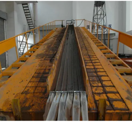
The laboratory flume measured 12 m×3 m, and the central portion was divided
into six 12 m×0.1 m sections by upright PVC boards (Fig. 1), to imitate well-defined
Figure 1 Experimental flume.
was packed with purple soil in layers of about 5 cm to a bulk density of approximately 1,300 kg m−3to simulate the cultivated layer. The soil near the flume walls was packed to be
slightly higher than the soil near the middle so that the water flow converged in the middle, which further minimized boundary effects. Prior to the experimental runs, the prepared rills were saturated by running a rainfall simulator for 24 h at an intensity of 60 mm/h to ensure that the water content was close to the field capacity.
Experimental design
We simulated rill erosion at five different slopes (5◦, 10◦, 15◦, 20◦, 25◦) and three water flow
Experimental methods
All sediment samples were collected in a sampling bucket placed at the rill outlet. After a period of water scouring and rill erosion, the soil flume was adjusted to the horizontal. Plastic film was twined in multiple layers to form eleven thin, waterproof; baffle plates the same width as the rill. The baffles were inserted at 0.5 m, 1 m, 2 m, 3 m, 4 m, 5 m, 6 m, 7 m, 8 m, 10 m, and 12 m from the rill entrance, thus dividing the eroded rill into the following sections: 0–0.5 m, 0.5–1 m, 1–2 m, 2–3 m, 3–4 m, 4–5 m, 5–6 m, 6–7 m, 7–8 m, 8–10 m and 10–12 m. The baffles were deep enough to prevent water from flowing between the rill sections.
Each section of rill was then filled with water and the soil erosion volume was calcu-lated by recording the volume of water in each rill section; then the quantity of soil erosion was calculated from the soil bulk. Unlike particulate matter such as soil, water fills the rill with no gaps. However, the impact of soil pores on the results can be excluded because the soil was pre-saturated. We obtained the values for rill erosion and sediment transport along the entire rill length from the cumulative values for each section.
Rill erosion proved to be low with a slope gradient of 5◦and a flow rate of 8 L/min, so
the lower flow rates of 2 L/min and 4 L/min were not tested at this gradient. Similarly, we did not test the 2 L/min flow rate with a 10◦slope because erosion was already very low at
the 4 L/min rate. All other combinations of gradients and flows rates were tested, resulting in twelve different experimental conditions in total. Each condition was repeated three times, resulting in a total of 108 separate trials.
Calculation of sediment transport along the rill length
Sediment concentration refers to the dry mass of sediment per unit volume of water:
Sci= 1,000•Msi
q•Δt (1)
Msi= 11
i=1
Viρb. (2)
In the formula,Sciis the total sediment content at the end of theith rill section (kg/m3), Msiis the cumulative mass of eroded sediment at the end of theith rill section (kg),qis the flow rate (L/min),Δtis the duration of each trial (min) (Zhao et al., 2014a;Zhao et al., 2014b);Viis the total volume of soil erosion in theith rill section, as measured by the volume replacement method (m3);ρbis the soil bulk density (kg/m3). FromEqs. (1)and (2), the sediment concentration can be calculated along the length of the rill, revealing the process of soil erosion along the rill length.
RESULTS AND DISCUSSION
After observing the overall trends in the experimental data, we used the following model to fit the data and reveal how rill sediment concentration changes with rill length:
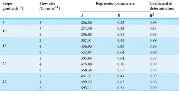
Table 1 Sediment concentration model parameters obtained under different experimental conditions.
Slope gradient/(◦)
Flow rate /(L·min−1)
Regression parameters Coefficient of determination
A B R2
5 8 206.56 0.25 0.98
4 274.39 0.28 0.93
10
8 296.88 0.31 0.96
2 387.31 0.41 0.99
4 456.93 0.43 0.99
15
8 532.97 0.64 0.99
2 395.84 0.64 0.98
4 476.80 0.70 0.99
20
8 548.56 0.57 0.96
2 451.71 0.41 0.99
4 499.22 0.62 0.96
25
8 595.11 0.51 0.99
C represents the sediment concentration(kg/m3); xrepresents the rill length (m);Arepresents the maximum possible sediment concentration in the flow,(kg/m3); Brepresents the decay rate for sediment concentration with speed of rill length increasing (1/m).
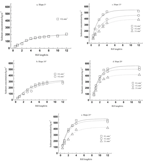
Equation (3)represents a situation in which sediment concentration increases with rill length, but the rate of increase decreases exponentially with distance along the rill, eventually tending towards a stable sediment concentration,A. WhenBincreases, the curve of the exponential function becomes steeper for a particular value ofA, meaning that the maximum sediment concentrationAis reached after a shorter distance along the rill. The experimental data fits to the model inEq. (3)are plotted inFig. 2, and demonstrate how purple-soil sediment concentration varies along the rill length, for the different slopes and flow rates.
The model parameters obtained under the different experimental conditions are listed inTable 1. The coefficient of determination(R2)was greater than 0.9 in each condi-tion, indicating that all fits to the model were very good. It can be seen from Fig. 2and Table 1that the tendency of purple-soil sediment concentration to increase with rill length was similar across conditions. Under conditions of known slope gradient and flow rate, the data followed the model closely: sediment concentration increased along the length of the rill but at a decreasing rate until the sediment concentration tended towards a stable value, and the rate of increase tended to zero.
Figure 2 Sediment concentration as function of rill length.
transports, and deposits the soil particles on the soil surface, destroying the soil structure (Zhang, Lei & Zhao, 2008;Cerd`a, 1999;Brevik et al., 2015;Cerd`a, 2001). The frictional force between rill flow and the soil surface influences the susceptibility to runoffscouring. In the context of our experiment, slope gradient affects the soil stress distribution: when the slope was steeper, the water flow dispersed and transported soil particles with greater speed and energy.
Table 1shows that, for identical slope gradients, parameterAincreases with increasing flow rates. Acan be considered to be the maximal potential sediment concentration for purple-soil rill flows. Our results therefore indicate that the maximal sediment concentration for purple-soil rill flow increases with flow rate under conditions of constant slope gradient. ParameterBrepresents the rate at which sediment concentration increases decay along the rill length. It can be observed fromTable 1thatBtended to increase with both slope gradient and flow rate, indicating a faster rate of increase in purple-soil sediment concentration with steeper slopes and greater flow rates. Similar results have been obtained in previous studies (Chen et al., 2014).
CONCLUSIONS
In this study, we investigated the process of rill erosion along the rill length by using a 12 m soil flume and the volume-replacement method. We used water to backfill the eroded rill because of its mobility and the ease of volume measurement. We ensured that there were no water leakages and so were able to quantitatively measure the process of rill erosion in purple soil. The relationship between sediment concentration and rill length was obtained by fitting the experimental data to a model with two free parameters. The results show that the sediment concentration increases along the length of the rill, and tends towards a stable value. The rate at which sediment concentration increases is highest at the rill entrance and then gradually decreases along the rill length. With steeper slopes and faster flow rates, the increase in sediment concentration is more obvious. These results may provide the basis for understanding the mechanisms of rill erosion and may provide estimates for parameter values in future simulated models of the erosion process in the purple soil.
ADDITIONAL INFORMATION AND DECLARATIONS
Funding
This work was supported by the Foundation of Graduate Research and Innovation in Chongqing under project CYS14054, and Construction Funds for Ecology Key Disciplines for Project 211 Southwest University. The funders had no role in study design, data collection and analysis, decision to publish, or preparation of the manuscript.
Grant Disclosures
The following grant information was disclosed by the authors:
Foundation of Graduate Research and Innovation in Chongqing: CYS14054.
Competing Interests
The authors declare there are no competing interests.
Author Contributions
• Yuhan Huang conceived and designed the experiments, performed the experiments,
analyzed the data, contributed reagents/materials/analysis tools, wrote the paper, prepared figures and/or tables, reviewed drafts of the paper.
• Xiaoyan Chen conceived and designed the experiments, performed the experiments,
reviewed drafts of the paper.
• Banglin Luo performed the experiments, contributed reagents/materials/analysis tools. • Linqiao Ding performed the experiments.
• Chunming Gong contributed reagents/materials/analysis tools, prepared figures and/or
tables.
Supplemental Information
Supplemental information for this article can be found online athttp://dx.doi.org/ 10.7717/peerj.1220#supplemental-information.
REFERENCES
Abrahams AD, Parsons AJ, Hirsh PJ. 1992.Field and laboratory studies of resistance to interrill overland flow on semi-arid hillslopes, Southern Arizona. London: UCL Press, 1–23.
Bhattarai R, Dutta D. 2007.Estimation of soil erosion and sediment yield using GIS at catchment scale.Water Resources Management21:1635–1647DOI 10.1007/s11269-006-9118-z.
Brevik EC, Cerd`a A, Mataix-Solera J, Pereg L, Quinton JN, Six J, Van Oost K. 2015. The interdisciplinary nature of Soil.Soil1:117–129DOI 10.5194/soil-1-117-2015.
Cai QG, Zhu YD, Wang SY. 2004.Research on processes and factors of rill erosion.Advances in Water Science15(1):13–18.
Casal´ı J, Loizu J, Campo MA, De Santisteban LM, ´Alvarez-Mozos J. 2006.Accuracy of methods for field assessment of rill and ephemeral gully erosion.Catena67:128–138
DOI 10.1016/j.catena.2006.03.005.
Cerd`a A. 1999.Parent material and vegetation affect soil erosion in eastern Spain.Soil Science Society of America Journal63:362–368DOI 10.2136/sssaj1999.03615995006300020014x. Cerd`a A. 2001.Effects of rock fragment cover on soil infiltration, interrill runoffand erosion.
European Journal of Soil Science52:59–68DOI 10.1046/j.1365-2389.2001.00354.x.
Chen JJ, Sun LY, Cai CF, Liu JG, Cai QG. 2013.Rill erosion on different soil slopes and their affecting factors (in Chinese).Acta Pedologica Sinica50(2):281–288.
Chen XY, Zhao Y, Mi HX, Mo B. 2014.Estimating rill erosion process from eroded morphology in flume experiments by volume replacement method.CatenaEpub ahead of print Feb 7 2015
DOI 10.1016/j.catena.2015.01.013.
Ellison WD. 1947.Soil erosion studies. Part VI. Soil detachment by surface flow.Agriculture Engineering28:402–408.
Gao Y, He NP, Yu GR, Tian J, Miao CY, Yang TT. 2014a.Impact of external nitrogen and
phosphorus input between 2006 and 2010 on carbon cycle in China seas. Regional
Environmental Change15(4):631–641DOI 10.1007/s10113-014-0664-2.
Gao Y, Zhu B, He NP, Yu GR, Wang T, Chen WL, Tian J. 2014b.Phosphorus and carbon competitive sorption-desorption and associated non-point loss respond to natural rainfall events.Journal of Hydrology517:447–457DOI 10.1016/j.jhydrol.2014.05.057.
Gao Y, Zhu B, Wang T, Wang YF. 2012.Seasonal change of non-point source pollution-induced bioavailable phosphorus loss: a case study of Southwestern China.Journal of Hydrology (420–421):373–379DOI 10.1016/j.jhydrol.2011.12.029.
Geng XD, Zheng FL, Liu L. 2010.Effect of rainfall intensity and slope gradient on the soil erosion process on purple soil hill slopes.Sediment Research6:48–53.
Kr¨opfl AI, Cecchi GA, Villasuso NM, Distel RA. 2013.Degradation and recovery processes in Semi-Arid patchy rangelands of northern Patagonia, Argentina.Land Degradation & Development24:393–399DOI 10.1002/ldr.1145.
Li ZB, Zhu BB, Li P. 2008.Advancement in study on soil erosion and water conservation.Acta Pedologica Sinica45(5):802–809.
Lei TW, Nearing MA. 2000.Laboratory experiments of rill initiation and critical shear stress in loose soil material (in Chinese).Transactions of the CSAE16(1):26–30.
Lei TW, Zhang QW, Yan YJ, Zhao J, Pan YH. 2008.A rational method for estimating erodibility and critical shear stress of an eroding rill. Geoderma 144:628–633
DOI 10.1016/j.geoderma.2008.01.015.
Lei TW, Zhang QW, Yan YJ. 2009.Rill erosion physical model. Beijing: Science Press, 102–116. Liu Z, Yao Z, Huang H, Wu S, Liu G. 2014.Land use and climate changes and their impacts
on runoffin the Yarlung Zangbo river basin, China.Land Degradation and Development 25:203–215DOI 10.1002/ldr.1159.
Miao CY, Ni JR, Borthwick AGL. 2010.Recent changes in water discharge and sediment load of the Yellow River basin, China.Progress in Physical Geography 34(4):541–561
DOI 10.1177/0309133310369434.
Miao CY, Ni JR, Borthwick AGL, Yang L. 2011.A preliminary estimate of human and natural contributions to the changes in water discharge and sediment load in the Yellow River.Global and Planetary Change76(3–4):196–205DOI 10.1016/j.gloplacha.2011.01.008.
Miao CY, Duan QY, Sun QH, Huang Y, Kong DX, Yang TT, Ye AZ, Di ZH, Gong W. 2014. Assessment of CMIP5 climate models and projected temperature changes over Northern Eurasia.Environmental Research Letters9(5):055007DOI 10.1088/1748-9326/9/5/055007. Miao CY, Ashouri H, Hsu K, Sorooshian S, Duan QY. 2015.Evaluation of the PERSIANN-CDR
daily rainfall estimates in capturing the behavior of extreme precipitation events over China.
Journal of Hydrometeorology16:1387–1396DOI 10.1175/JHM-D-14-0174.1.
Nearing MA, Norton LD, Bulgakov DA. 1997.Hydraulics and erosion in eroding rills.Water Resources Research33(4):865–876DOI 10.1029/97WR00013.
Olson KR, Beavers AH, Fan ZG. 1989.Methods to estimate soil loss (in Chinese).Scientific and Technical Information of Soil and Water Conservation2:34–40.
Xiao PQ, Zheng FL, Jia YY. 2003.Loess hill slope erosion and sediment yield process using a dual box system.Science of Soil and Water Conservation1(4):10–15.
Yan LJ, Yu XX, Lei TW, Zhang QW, Qu LQ. 2009.Finite element model for calculating effects of slope flow sediment transport capacity and soil erodibility on rill erosion process (in Chinese).
Acta Pedologica Sinica46(2):192–200.
Yan DC, Wen AB, Shi ZL, Ju M, He XB. 2010.Critical slope length and control of rill occurrence on cultivated land of purple soil in Sichuan Basin.Research of Soil and Water Conservation 17(6):1–4DOI 10.2489/jswc.65.1.1.
Yan DC, Wang YF, Wen AB, Su M, He XB. 2011.Configuration evolvement of rill development on purple slope land (in Chinese).Mountain Science29(4):469–473.
Zhang QW, Lei TW, Pan YH, Xia WS, Liu JG. 2002.Dynamic sediment yield of rill erosion.
Transactions of the CSAE18(2):32–35.
Zhao HB, Cao JJ, Yao WY, Shen ZZ. 2014a.Experimental study on process of sediment transport and overland flow on the loess slope.Research of Soil and Water Conservation21(1):90–94. Zheng FL. 1989.A research on method of measuring rill erosion amount.Bulletin of Soil and Water
Conservation9(4):41–49.
Zhang QW, Lei TW, Zhao J. 2009.Study of detachment rate in rills with the REE tracing method (in Chinese).Acta Pedologica Sinica42(1):163–166.
Zhang QW, Lei TW, Zhao J. 2008. Estimation of the detachment rate in eroding
rills in flume experiments using an REE tracing method. Geoderma 147:8–15
DOI 10.1016/j.geoderma.2008.07.002.
Zhao Y, Chen XY, Mi HX, Mo B. 2014b.A volumetric method based study on distribution of erosion along rills on loess slope.Acta Pedologica Sinica51(6):1234–1241.
Zhao X, Wu P, Gao X, Persaud N. 2015.Soil quality indicators in relation to land use and topography in a small catchment on the loess plateau of china.Land Degradation and Development26:54–61DOI 10.1002/ldr.2199.
Zhao G, Mu X, Wen Z, Wang F, Gao P. 2013.Soil erosion, conservation, and Eco-environment changes in the Loess Plateau of China.Land Degradation & Development 24:499–510