GEMMA: A GENERIC, EXTENSIBLE AND MODULAR MULTI-SENSOR NAVIGATION
ANALYSIS SYSTEM
J. A. Navarroa,∗
, M. E. Par´esa,*, I. Colominab
a
CTTC, Av. Carl Friedrich Gauss 7, 08860 Castelldefels, Spain - (jose.navarro, eulalia.pares)@cttc.es bGeoNumerics S.L., Av. Carl Friedrich Gauss 11, 08860 Castelldefels, Spain - ismael.colomina@geonumerics.com
ICWG III/I
KEY WORDS:Trajectory determination systems, Research toolset, Navigation, Sensor orientation
ABSTRACT:
This paper presents the concept of an architecture for a system that helps researchers in the field of Geomatics to speed up their daily research on kinematic geodesy, navigation and positioning fields. The presented ideas correspond to an extensible and modular software system aimed at the development of new navigation and positioning algorithms as well as at the evaluation of the performance of sensors. The concept, already implemented in the CTTC’s system GEMMA is generic and extensible. This means that it is possible to incorporate new navigation algorithms or sensors at no maintenance cost. Only the effort related to the development tasks required to either create such algorithms or model sensors needs to be taken into account. As a consequence, change poses a much smaller problem for CTTC’s research activities is this specific area. This system includes several standalone tools that may be combined in different ways to accomplish various goals; that is, it may be used to perform a variety of tasks, as, for instance, (1) define positioning and navigation scenarios, (2) simulate different kinds of sensors, (3) validate new navigation algorithms or (4) evaluate the quality of an estimated navigation solution.
1. INTRODUCTION
Nowadays, the research community is constantly developing new positioning and navigation algorithms. These algorithms aim at the determination of precise, accurate and robust trajectories. By trajectory we mean a path of an stochastic process; that is, it is one of the many time series realizations of an stochastic process. In the context of this paper, a trajectory is a time series of positions, velocities and attitudes of a moving object plus the calibration parameters of the instruments used to determine these as well as the estimated covariances of all the aforementioned values.
The navigation research community is currently dealing with two challenges: new technologies and their use in new applications. New sensors, able to provide data suitable for geoapplications, appear constantly in the market. As stated in (Groves et al., 2014a, Groves et al., 2014b), technology has to deal with new sensors—like plenoptic or photon-mixing cameras—, new per-formances—like the inertial sensors found in smartphones—and new environments—like indoor or urban canyons. Furthermore, there are still many issues to solve concerning the achievement of target precision, accuracy and reliability in the realm of position-ing and navigation. The followposition-ing are some examples: for mo-bile mapping purposes, GNSS accuracy is almost unachievable due to strong multipath in narrow urban environments (Xie and Petovello, 2015); completely autonomous or unattended driven systems (in aerial, marine or submarine environments) are still a wish for the surveying community due to the lack of reliabil-ity of navigation solutions (Velaga et al., 2012); kinematic air-borne gravimetry is not able yet to reach the maximum preci-sion because of the high level of noise present in INS/GNSS sys-tems (Skaloud et al., 2015).
The examples above define an scenario where continuous and in-tense research in a steadily changing technological environment is taking place. This constant, uninterrupted change and evolution
∗
Corresponding authors.
process constitutes a challenge (for instance, from the software engineering standpoint) for the research activities in this area.
Nowadays, researchers have at their hand a wide range of help-ful tools (either proprietary, free or open source). However, these have been conceived to perform rather specific tasks and not as components of a larger (tool) ecosystem. It is possible, for in-stance, to find MATLABR code to generate synthetic trajecto-ries (Ahmadzadeh, 2015), signal (IFEN, 2015) and measure-ment (MathWorks, 2015) generators or reliable and widely known trajectory determination and analysis systems like the Applanix or the Waypoint ones. Unfortunately, and in spite of (and be-cause of) this availability of tools, researchers will have to cope with problems as data format incompatibilities or, in the worst case, develop a full trajectory determination system when new algorithms need to be implemented.
This paper presents the concept of an architecture for a system whose target is to provide a reliable framework where research related to positioning, navigation and sensor modelling may take place. The goal of such system is to become the basic toolset for researchers in these areas, avoiding the need to start anew each time a new project begins or, thanks to some of the tools included in this architecture, not having to organize and execute costly data acquisition campaigns when (new or not) sensors need to be eval-uated. Additionally, an implementation of the aforementioned concept and architecture, is presented here: GEMMA (Generic Extensible andModular Multi-sensor navigation Analysis sys-tem).
GEMMA is a portable, extensible and modular software system aimed at the development of new navigation and positioning algo-rithms as well as at the evaluation of the performance of sensors. It has been conceived as a research toolset useful in laboratory en-vironments (as opposed to workshop or factory ones) (Navarro, 1999).
implementa-tion decided to incorporate some characteristics present in prod-ucts that are, indeed, commercial ones. For instance, GEMMA intends to be acompletetoolset or suite, providing anintegrated environmentwhere research tasks and work flows are facilitated; a data abstraction and their corresponding interface has been de-vised as well,to avoid impedancesbetween the tools integrating this suite, since the need of file converters is noticeably reduced; a batch interface exists, making possible theautomation of repet-itive tasks, while a—still very immature— graphic interface has been included to ease the interaction with end-users (researchers). In short, the essential traits (as scientific rigour) that are a must in a software toolset targeted at research have been complemented with other characteristics usually present in commercial systems.
Section 2. describes the architecture (and components) of GEM-MA from the conceptual and implementation standpoints (show-ing how the GEMMA system materializes the concept). Sec-tion 3. details how this system may be used in different scenarios (use-cases or work flows).
2. CONCEPT AND ARCHITECTURE
The architecture (and components) of a framework willing to pro-vide with a useful set of tools and procedures to facilitate the re-search tasks related to a specific set of disciplines may obviously vary depending on the actual experience of the people involved first in its inception and, later on, in its design and implementa-tion stages. This paper presents, therefore, the view of its authors, view that has been heavily influenced by their participation in a series of projects where the framework discussed here played a key role. Nonetheless, after several years of being put to the test, the implementation of the architecture discussed below has been able to cope with all the challenges faced up to the moment.
The components included in a positioning and navigation research framework should be able to offer, at least, the following set of features:
• Generation (densification) of realistic trajectories for any kind of platform: from spacecrafts, to aerial, terrestrial or marine vehicles, or even alive organisms;
• simulation of signals (measurements) for several types of sensors, as, for instance, IMUs or GNSS receivers,
• sequencing of sensor measurements,
• trajectory estimation and
• (trajectory) quality assessment.
Each of the features (and related tools) in the list above is impor-tant by itself. For instance, the ability to generate and densify tra-jectories avoids having to obtain such tratra-jectories by other meth-ods; when signal (measurement) generators are available, there is no need to organize data collection campaigns. In short, these tools help to save time and reduce costs, thus facilitating the work of researchers. However, it is the combination of different sub-sets of these features (tools) what reveals the versatility of the concept, and how it responds to different research use cases (see section 3.).
GEMMA implements these features, providing a tool for each of them. In particular, it includes four signal generators, for IMUs, magnetometers, odometers and GNSS receivers.
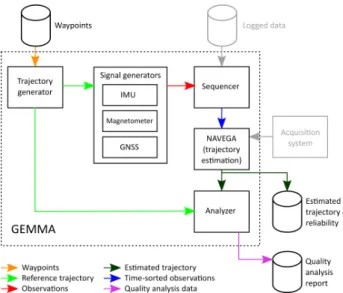
Figure 1 depicts all the features just discussed (implemented as a set of tools in the GEMMA system). Additionally,allthe possi-ble data flows between these are shown. Depending on the actual
scenario being tackled (see section 3. for some examples), only a subset of these tools and data flows will be used. For instance, when not working in a real-time environment, the trajectory es-timation tool will not be connected to an acquisition system but will use logged (pre-recorded) data (measurements), information coming from one or more of the available signal generators, or both.
Figure 1: GEMMA components and work flow
The following sections describe briefly the different components of the architecture and show how GEMMA implemented these.
2.1 Trajectory Generation
The ultimate goal of the trajectory generator tool is to create ref-erence trajectoriesto compare with when these do not exist or it is too expensive to obtain them—for instance, flying a real plane.
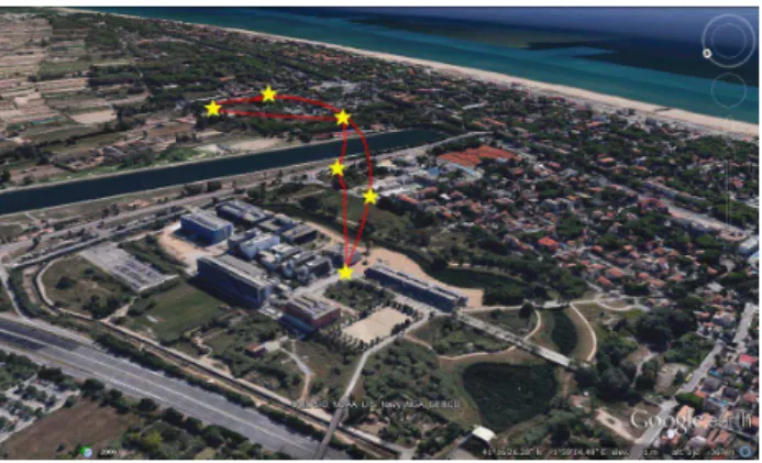
Strictly speaking, this tool is not about fully trajectory genera-tionbut about trajectorydensification. Given a set of way points (time-tagged positions, and eventually attitudes) an infinite num-ber of trajectories can be derived. The tool should be able to produce a denserealistictrajectory including not only the previ-ous way points but a much more extensive list of them as well as related velocities and orientations. Figure 2 depicts a densified trajectory using a few way points.
Figure 2: Example of a densified trajectory
the way points and the related orientation definition adhere to the specific dynamics of the selected platform. This translates into an extensible software component where the densification process is independent of the selected vehicle dynamics.
For versatility (and flexibility) reasons, the generator must be able to accept way points generated by different sources, as for in-stance, KML files or trajectories output by (realistic) flight simu-lators—file format converters may be needed to do so. The pa-rameters controlling the behaviour of the tool (as the output fre-quency) must be also configurable by the user.
GEMMA includes a trajectory generation tool complying with the functional requirements discussed above. Specifically, it is able to achieve the infinitely derivable position and orientation by convolving with aC∞
function and later on interpolating the resulting trajectory at the rate selected by the user; the realistic orientation for different platforms is obtained from the dynamics formulas of those vehicles (Rajamani, 2011, Roskam, 1995).
2.2 Signal Generators
A (software) signal1 generator simulates the observations that would have been delivered by a sensor if it would have actually been used in a real campaign.
Signal generators take as input a reference trajectory—however obtained—and use themodelsdefining the behaviour of the sen-sor these mimic to deliver the simulated observations. Note that these models must include theerrorsaffecting the sensors, so output data mirrors thisdefectivebehaviour.
Errors may correspond to various stochastic processes (as random walks, white noise or Gauss-Markov ones). Additionally, errors may be originated by different sources, as the instrument itself, the environment (temperature, magnetic fields, humidity among many others) or the platform the instrument is mounted on (ve-hicles, human or animal carriers). These kinds and sources of errors must be taken into account by a signal generator so reality is properly mirrored.
Signal generators may be either software or hardware compo-nents and the presented architecture makes no distinctions be-tween these. Software components, apparently, are less prone to obsolescence since it is possible to include new features just by maintaining the code.
There are different situations where the use of such generators prove to be useful. These are some, among others:
• To check how the quality of an estimated trajectory is im-proved by incorporating a sensor that is not available—but correctly modelled.
• To select the appropriate quality of a sensor according to the requisites that the estimated navigation solution must meet. For instance, a tactical grade GNSS receiver may not be nec-essary in all situations.
For instance, Figure 3 shows the behaviour of two different IMUs travelling along the same reference trajectory. Purple data cor-responds to a low-cost IMU unit while the green bar represents how a navigation-grade IMU behaves. The different responses of these two sensors are easily identifiable.
1The wordssignal,measurementandobservationare incorrectly used
as synonyms here for the sake of simplicity. For instance, in some situa-tions, additional processing may be needed to obtain a measurement out of a signal, but such distinction is not made in this paper.
Figure 3: Example of output of an IMU signal generation tool
At the moment of writing this paper, GEMMA includes four types of signal generators fully compliant with the functional de-scription above, namely odometers, magnetometers, GNSS re-ceivers and IMUs (Par´es et al., 2015). Others may be included in the future when needed. A hardware GNSS simulator, the IFEN NavX-NCS PROFESSIONAL GNSS simulator (IFEN, 2015), is also part of the system.
It is important to highlight that there exist nowadays many signal generators in the market for a variety of sensors—see (Ebinuma, 2015) and (Nievinski and Larson, 2014) for two examples of available GNSS simulators or (Yang et al., 2007) and (Yan et al., 2015) for IMU ones. In spite of this availability, the team in charge of the development of GEMMA decided to implement its own signal generators.
The extra cost of developing tools that already exist in the market is justified by several reasons that were deemed strategic. First, an in-house development allows for a higher degree of freedom when implementing a sensor simulator; additionally, it is possi-ble to incorporate any kind of error models that other tools might have not considered; moreover, the data formats used by in-house developments may be GEMMA’s own, reducing the data con-version steps needed to make data suitable for other tools in the toolset; last, but not least, it is possible to design these generators in such a way that these may be integrated in batch production en-vironments (to avoid the unnecessary repetition of routine tasks) and, at the same time, include a user-friendly graphic interface fa-cilitating the interaction between the researcher and the tool when required.
2.3 Sequencer
The goal of the sequencer is to sort a series of heterogeneous ob-servations in ascending time order. In this context,heterogeneous stands fororiginating in different kinds of sensors. The need to sort input data is motivated by the fact that the estimation of the successive values of the states integrating a trajectory is based on the use of observations that areclosein time.
A sequencer takes as input a series of files or TCP/IP (T rans-missionControlProtocol /InternetProtocol) socket connections containing or transmitting time-tagged observations measured by different sensors and outputs a single stream of data including these same observations conveniently sorted. This output stream may be either written to a file (for local, batch processing) or sent through a TCP/IP socket connection (remote, batch processing).
and, in this situation, some delays or shifts related to time stamps are to be expected. Therefore, such a tolerance parameter may be used to alleviate these discordances. Obviously, the trajectory estimation tool (see section 2.4) must be able to cope with such non-perfectly time-sorted stream of data for this feature to be of any use at all.
GEMMA includes a sequencer tool implementing almost all the features described above. The only limitation is that it is only able to accept input data stored in files (network input is not yet ac-cepted), so the discussion related to time tolerances do not apply here. The ability of the sequencer to send its output through a net-work connection opens the way todistributed research, which has been put into practice in several projects, as ATENEA (Fern´andez et al., 2011): observation data is obtained in one place, sequenced there, and sent via sockets to a second place, where it is pro-cessed.
2.4 Trajectory Estimation
The goal of this tool is to estimate trajectories (navigation solu-tion) out of a series of time-sorted, heterogeneous sensor obser-vations.
New sensors—the source of observations—appear constantly in the market and old ones are improved or modified. To cope with constant change and innovation, a trajectory estimator should be designed to be a generic and extensible tool, so the heavy toll that should be paid in terms of software maintenance due to such evolution may be avoided. To do so, the following principles should be the cornerstones on which a tool like this should rely:
• Separation of estimation and modelling. The tool must sepa-rate the estimation—“number crunching”—engine from the data being used and its relations. This allows a quick ex-tension of the software when new sensors appear. When the tool starts, it must load the components related to the intervening sensors as well as some mission-related states. These components, whatever they are, must not affect how the computational kernel (the estimation engine) behaves. In this way, the inclusion of new sensors imply the devel-opment of only relatively small fragments of code that are materialized as the aforementioned loadable components.
• Rigorous data modelling. Data must be modelled to repre-sent the esrepre-sential traits defining the four entities identified as key players in the positioning and navigation realm: (input) measurements, (input) auxiliary instrument constant values, (output) states and (equation) models relating all those ele-ments. The abstraction must therefore be generic and able to manage, at the same time, the variety of available sen-sors. Relying in a rigorous data model implies that the im-plementation or maintenance of sensor models may bene-fit of code reuse and object-orientation techniques—and its encapsulation, inheritance and polymorphism mechanisms. This leads to a substantial simplification of the system and much shorter times to implement new sensors, measurement and state models in the software.
• Generic and adaptable interface. The input / output inter-face of the trajectory estimator must mirror the data abstrac-tion process just stated, so the inclusion of new sensors im-plies no changes in the way data are handled. To enable either batch or real-time processing, at least two data in-terfaces should be defined: file and network—this last one based on TCP/IP sockets.
• Computational strategy object. Sensors (equipment) are not the only factor affecting the quality of a navigation solu-tion. Environmental conditions must also be taken into ac-count (Groves et al., 2014a, Groves et al., 2014b); the kind
of vehicle used (airplane, helicopter, terrestrial vehicle, to mention some) imposes a very different set of constraints on what kind of trajectories are possible. For instance, sud-den changes in the direction of movement are possible when equipment is carried by people, while airplanes are not able to do so. A trajectory determination system should be aware of these limitations that depend on the context, either be-cause it has been informed by the user or being able to deter-mine these by itself when no information is available. This is the task of the computational strategy object. This compo-nent must be able to determine—depending on the context it is working in—whether there is enough information to com-pute a solution and what to do when the answer is negative— as for instance, deliver a partial solution or just warning about its inability to proceed. The computational strategy object must be independent from the estimation (“number crunching”) engine; this approach allows for the combina-tion of different sensor models and environments (contexts) at no (source code) maintenance cost.
The channels used for input (observations) and output (trajecto-ries) data must be selectable freely; that is, any combination of file or TCP/IP sockets data channels for input or output must be possible. In this way, it is possible to use the trajectory estimation tool in a wide variety of scenarios. For instance, it may work as a real time (navigation)data loggerusing sockets on input and files on output; if both input and output channels are TCP/IP sockets, then the tool works as a real-time navigation system. Using files in both channels transforms the trajectory estimator into a batch tool.
NAVEGA (Par´es and Colomina, 2015) is the trajectory estima-tion component included in GEMMA. It has been designed ac-cording to the principles described above. In short, the most im-portant features of NAVEGA are:
• Robust trajectory estimation,
• using a geodetic approach, that is able to
• perform multi-sensor navigation,
• detecting and isolating faults,
• running either in real-time or batch environments, and that
• is available for the most common operating systems.
Currently, the number crunching engine of NAVEGA includes a family of Kalman filter algorithms and provides with Gaussian states, this is, the output are expected values and covariance ma-trices. Furthermore, it also provides the user with expected resid-uals and standard deviation values, suitable for a posteriori tra-jectory analysis (see section 2.5).
Regarding robustness issues, NAVEGA’s implemented analysis tools are able to deal with odometers and camera outliers. When working with GNSS modelling, the system is able to detect out-liers when these affect just one satellite. At this moment, more than one outlier cannot be properly detected.
Integrability is also a fact. It has been used in the framework of several projects as a location provider of different services, like mobile mapping systems (Fern´andez et al., 2011) or a GNSS receiver with tight coupling capabilities (Silva et al., 2006).
The use of NAVEGA in the aforementioned examples served to verify that this component is not only available for a wide range of platforms but also that its performance suits the needs of these. For instance, NAVEGA is able to process INS/GNSS solutions at 5000 Hz in real time when running on an Odroid-XU3 (HardKer-nel, 2015) with a negligible latency.
Finally, but no less important, the dual interface of the system (file and GUI) makes NAVEGA suitable for both Kalman filter experts and inexperienced users as well.
2.5 Analyser
The last tool in the system is the trajectory analyser. As its name indicates, the aim of this tool is to perform several quality analysis over an estimated trajectory. The main features it should include are:
• Given a reference trajectory, which is considered as the ab-solute truth, the system should be able to “translate” one trajectory to the other one and to compare them. By “trans-lation” we mean to apply the user’s requested offset and boresight matrix. The analyser should be able to compute statistics (like, mean, standard deviation and RMSE) fully describing the difference between these, which is the cor-nerstone to assess the quality of the estimated trajectory.
• Given a reference trajectory, the system should be able not only to compare estimated and reference trajectory as viously stated but also to check its coherence with the pre-dicted error, and to determine if those last values are under-or overestimated.
Given the residuals or the innovations of an estimated trajectory the system should be able to determine the stochastic process be-neath them, and to check if it is coherent with the expected one (typically white noise).
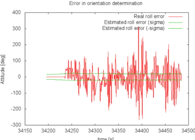
GEMMA’s trajectory analyser implements all the aforementioned features. Additionally, it is able to produce a series of plots de-picting some of the statistics discussed above to help to better understand them.
Figure 4 is an example of one of these plots: there, the actual error of an estimated trajectory (comparison between estimated and reference trajectories—in red) and the standard deviation of the estimator predicted error (in green) are shown. It may be observed how the estimated and actual errors do not match; thus, the trajectory determination system is being optimistic.
3. USE CASES
A toolset such the one presented in this paper may be used in a variety of research use cases, just combining, in different ways, the components that integrate it. The most usual use cases are:
Figure 4: Quality plot from the analyser tool
• Technology selection or validation.
• Algorithm verification and validation.
• Navigation and positioning in real-life environments.
The following sections describe these use cases and the role that play the different components of the toolset in each of these sit-uations. All the presented use cases have been successfully ad-dressed with GEMMA.
3.1 Use Case: Technology Selection or Validation
This use case takes into account two possible situations:
• It is necessary to select a sensor among a family of these whose quality is good enough—but not necessarily better— to estimate output trajectories that must match some preci-sion and accuracy requirements. For instance, not all appli-cations need a navigation-grade IMU, but it may be costly enough to determine what is the actual quality level that will guarantee the required output.
• Assessment of the quality of a single sensor, that is, deter-mining whether it is appropriate for the requisites affecting the estimated trajectory.
The advantage of using GEMMA in this case is that it is possi-ble tosimulatethe signals produced by these sensors and then estimate and evaluate, for each candidate, the respective output trajectories. Needless to say, proper modelling of the behaviour of the intervening sensors is required.
The components of GEMMA involved in this use case are shown in Figure 5. There, those GEMMA components that do not inter-vene in the use case are shown in pale grey.
The following would be the typical work flow to follow:
• First of all, a reference trajectory is needed to compare it with the output estimated ones. It may be either syntheti-cally generated by means of the trajectory generator compo-nent or taken from any field campaign.
Figure 5: The technology selection use case.
• Then the sequencer would time-sort all the observations pro-duced by the signal generators.
• The trajectory estimator component (NAVEGA) would be used to estimate the output trajectory, and, finally,
• the quality of the aforementioned trajectory would be as-sessed by the analyser component.
When comparing several sensor candidates to select the most ap-propriate one, the process above should be repeated for every sen-sor being evaluated. If the goal is just to determine whether a sensor is good enough to fulfil the stated goal (trajectory quality) then a single run should suffice.
A real project where this use case was put to the test was GINSEC (Navarro et al., 2015).
3.2 Use Case: Algorithm Verification and Validation
It has been stated several times in this paper that GEMMA is generic and extensible. This means that new sensors may be in-cluded into the system—or, those that have been modified, easily adapted—at almost no cost.
Including a new sensor means writing the mathematical equations modelling its behaviour and generating a loadable library includ-ing the new model. There is no need to change already existinclud-ing software to make the new model available to GEMMA; that is, when adding new sensors there is no need to maintain, change or adapt the existing code base. The new model will be loaded dy-namically upon request—that is, when data related to such model is processed.
As it happens to any kind of algorithm, it is necessary to verify and validate new models in order to guarantee their correctness (that is, the new code contains no bugs) and performance (the new sensor is correctly modelled). This is the algorithm verification and validation use case.
Figure 6 shows the components in the GEMMA system playing a role in this situation (note that, in this figure, those components not intervening in the process are shown in pale grey).
The sequence of steps to take when verifying and validating a new algorithm is defined below. A reliable reference trajectory, how-ever, must be generated beforehand. To create such trajectory, a
Figure 6: Algorithm verification and validation use case.
data collection campaign involving not only a set oftrusted sen-sors—that is, already correctly modelled—but also the new one must take place.
The reference trajectory must be estimated using only trusted sen-sors,so it is a reliable one to compare with(note that Figure 7 describes this procedure). Data coming from the new sensoris just logged, and will be later used to verify and validate the new model being developed.
Once the reference trajectory and the new sensor data are avail-able, the procedure to follow is:
1. Using the sequencer tool, data coming from all the sen-sors involved in the data collection campaign must be time-sorted.
2. The mathematical equations modelling the new sensor must be written. This, essentially, means filling the gaps in a tem-plate provided in GEMMA’s developer kit; such temtem-plate adheres to the API (ApplicationProgrammingInterface) de-fined by the system. In this way, developers need to have no prior knowledge about the internals of GEMMA; their knowledge may be just limited to sensor modelling 3. A dynamically loadable library is then created and included
in the GEMMA system.
4. NAVEGA is used to estimate a new trajectory.
5. The trajectory analyser is then used to compare the reference trajectory with the newly estimated one, thus assessing its quality.
Steps 2 to 5 may have to be repeated several times until the quality of the mathematical model is satisfactory.
Several projects that took place in the past were clear examples of this use case: GAL (Skaloud et al., 2015), ENCORE (Colomina et al., 2012) and ATENEA (Fern´andez et al., 2011).
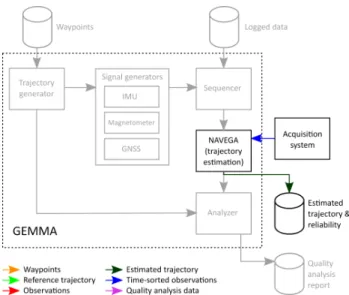
3.3 Use Case: Navigation and Positioning in Real-life Envi-ronments
Figure 7: Real-time environments use case.
Loaded with the appropriate set of models (those characterizing the sensors integrating an external acquisition system) NAVEGA might be used as a real-time server providing successive position and attitude values to some other subsystem(s). For instance, an autopilot system might decide to delegate the task of positioning the aircraft to NAVEGA, feeding this component with data com-ing from the different sensors on board, instead of performcom-ing this process itself. The GINSEC project (Navarro et al., 2015) is an example of this approach, where an implementation of a posi-tioning server inspired by NAVEGA was installed on a low-end board. Of course, other subsystems in need of georeferencing in real-time may benefit from such positioning server concept.
A variation of the example above would compute position and at-titude in real-time but log these data to permanent storage instead. This situation is typical in post-processing environments, when higher accuracy and precision are required. Processing the data collected with NAVEGA by means of techniques as PPP (Point PrecisePositioning) would improve the quality of the estimated trajectory to the level required by professional applications (as network bundle adjustment, for instance).
The project CLOSE-SEARCH (Molina et al., 2012a) is a typical example of this use case.
4. CONCLUSIONS
GEMMA is not only a concept but also a real, seasoned, research-oriented system, that has made possible a significant number of research projects in the past, covering a wide spectrum of situa-tions within the realm of kinematic geodesy, positioning, naviga-tion, and related disciplines and applications. This has been pos-sible thanks to the principles supporting its architecture, mainly genericity and extensibilty, as well as a powerful set of data and interface abstractions. These principles were crucial to cope with change and innovation from the very beginning, and still are.
GEMMA is composed of a variety of tools whose combination opens the path to its exploitation (as a research tool) in the most usual scenarios where navigation is involved, as the evaluation / modelling of new sensors or real-time navigation. At least one of these tools, the IMU signal simulator, as well as the definition of the generic and extensible data interface, are candidates to be put into the public domain (for more details, contact any of the corresponding authors).
ACKNOWLEDGEMENTS
The research reported in this paper started around eight years ago at the former Institute of Geomatics and has been funded by means of several European projects. We would like to highlight IADIRA, ATENEA, ENCORE, CLOSE-SEARCH, GAL and GIN-SEC.
REFERENCES
Ahmadzadeh, R., 2015. Trajectory
gener-ation (3rd & 5th orders). http://www. mathworks.com/matlabcentral/fileexchange/
40278-trajectory-generation--3rd---5th-orders-. Accessed: 24 November 2015.
Angelats, E., Molina, P., Par´es, M. E. and Colomina, I., 2014. A parallax based robust image matching for improving multisensor navigation in GNSS-denied environments. In: Proceedings of the 27th International Technical Meeting of The Satellite Division of the Institute of Navigation (ION GNSS+ 2014), Tampa, USA, pp. 2132–2138.
Angelats, E., Par´es, M. E. and Colomina, I., 2011. Methods, algorithms and tools for precise terrestrial navigation.
Colomina, I., Miranda, C. and Par´es, M. E., 2012. Galileo’s sur-veying potential. GPS World.
Ebinuma, T., 2015. GPS-SDR-SIM. https://github.com/ osqzss/gps-sdr-sim. Accessed: 21 March 2015.
Fern´andez, A., Diez, J., de Castro, D., Dovis, F., Silva, P., Friess, P., Wis, M., Colomina, I., Lindenberger, J. and Fern´andez, I., 2011. ATENEA: Advanced techniques for deeply integrated GNSS/INS/LiDAR navigation. In: Proceedings of the 24th Inter-national Technical Meeting of The Satellite Division of the Insti-tute of Navigation (ION GNSS), Portland, OR, USA, pp. 2395– 2405.
Groves, P. D., Wang, L., Martin, H. and Voutsis, K., 2014a. To-ward a unified PNT - Part 1, complexity and context: Key chal-lenges of multisensor positioning. GPS World 25(10), pp. 18–49.
Groves, P. D., Wang, L., Martin, H. and Voutsis, K., 2014b. To-ward a unified PNT - Part 2, ambiguity and environmental data: Two further key challenges of multisensor positioning. GPS World 25(11), pp. 18–35.
HardKernel, 2015. Odroid XU3 — Hardkernel.
http://www.hardkernel.com/main/products/prdt_ info.php?g_code=G140448267127. Accessed: 22 March 2015.
IFEN, 2015. NavX-NCS Professional GNSS
Simulator. http://www.ifen.com/products/
navx-ncs-professional-gnss-simulator.html. Ac-cessed: 6 October 2015.
MathWorks, 2015. Three-Axis Inertial Measurement Unit. http://es.mathworks.com/help/aeroblks/ threeaxisinertialmeasurementunit.html. Accessed: 25 November 2015.
Molina, P., Par´es, M. E., Colomina, I., Victoria, T., Silva, P., Skaloud, J., Kornus, W., Prades, R. and Aguilera, C., 2012b. Drones to the rescue! Inside GNSS July/August, pp. 36–47.
Monta˜no, J., Wis, M., Pulido, J. A., Latorre, A., Molina, P., Fern´andez, E., Angelats, E. and Colomina, I., 2015. Validation of inertial and imaging navigation techniques for space applica-tions with UAVs. In: Proceedings of Data Systems in Aerospace, Barcelona, Spain.
Navarro, J. A., 1999. Object-oriented technologies and beyond for software generation and integration in Geomatics. PhD thesis, Universitat de les Illes Balears.
Navarro, J. A., Par´es, M. E., Colomina, I., Bianchi, G., Pluchino, S., Baddour, R., Consoli, A., Ayadi, J., Gameiro, A., Sekkas, O., Tsetsos, V., Gatsos, T. and Navoni, R., 2015. A redundant GNSS-INS low-cost UAV navigation solution for professional applica-tions. In: International Archives of the Photogrammetry, Re-mote Sensing and Spatial Information Sciences, Vol. XL-3/W3, La Grande Motte, France, pp. 299–306.
Nievinski, F. and Larson, K., 2014. An open source GPS multi-path simulator in Matlab/Octave. GPS solutions 18(3), pp. 473– 481.
Par´es, M. E. and Colomina, I., 2015. On software architecture concepts for an unified, generic and extensible trajectory deter-mination system. In: Proceedings of the ION GNSS+, Tampa, USA, pp. 2518–2526.
Par´es, M. E., Navarro, J. A. and Colomina, I., 2015. On the generation of realistic simulated inertial measurements. In: Pro-ceedings of the ISS Gyro Symposium, Karlsruhe, Germany.
Rajamani, R., 2011. Vehicle dynamics and control. Springer Science & Business Media.
Roskam, J., 1995. Airplane flight dynamics and automatic flight controls. DAR corporation.
Silva, P., Silva, J., Caramagno, A., Wis, M., Par´es, M. E., Colom-ina, I., Fern´andez, J., Diez, J. and Gabaglio, V., 2006. IADIRA: Inertial aided deeply integrated receiver architecture. In: Pro-ceedings of the 19th International Technical Meeting of the Satel-lite Division of The Institute of Navigation (ION GNSS 2006, Fort Worth, USA, pp. 2686–2694.
Silva, P., Silva, J., Peres, T., Colomina, I., Miranda, C., Par´es, M. E., Andreotti, M., Hill, C., Galera, J., Camargo, P., Diez, J., Palomo, J. M., Barbin, S., Moreira, J., Streiff, G., Grane-mann, E. and Aguilera, C., 2011. ENCORE: Enhanced Galileo code receiver for surveying applications. In: Proceedings of the 24th International Technical Meeting of The Satellite Division of the Institute of Navigation (ION GNSS 2011), Portland, USA, pp. 3679–3689.
Skaloud, J., Colomina, I., Par´es, M. E., Bl´azquez, M., Silva, J. and Chersich, M., 2015. Progress in airborne gravimetry by com-bining strapdown inertial and new satellite observations via dy-namic networks. In: Proceedings of the IUGG 2015 conference, Prague, Czech Republic.
Velaga, N. R., Quddus, M., Bristow, A. L., Zheng, Y. et al., 2012. Map-aided integrity monitoring of a land vehicle navigation sys-tem. IEEE Transactions on Intelligent Transportation Systems 13(2), pp. 848–858.
Xie, P. and Petovello, M. G., 2015. Measuring GNSS multipath distributions in urban canyon environments. IEEE Transactions on Instrumentation and Measurement 64(2), pp. 366–377.
Yan, G., Wang, J. and Zhou, X., 2015. High-precision simula-tor for strapdown inertial navigation systems based on real di-namics from GNSS and IMU integration. In: Proceedings of the China satellite navigation conference (CSNC), Vol. 3, Xi’an, China, pp. 789–799.