141
P. Meire et al. (eds.), Integrated Water Management: Practical Experiences and Case Studies, 141–153.
IN THE SEVEN CITIES BASIN
TOMAZ PONCE DENTINHO*, JOÃO PORTEIRO, HELENA
CALADO, EMILIANA SILVA, JOSÉ CARLOS FONTES, PAULO BORGES
UAC- Azores University, Portugal JOÃO MARQUES
UCP - Catholic University, Portugal RICHARD JONKER
AS - AquaSense Grotmij, The Netherlands JOSÉ FERREIRA
UTL - Technical Universty of Lisbon, Portugal
Abstract. The Sete Cidades lake in the Azores, is located in a volcanic crater.
Increased frequency of logging (380 hectares of production forests) and the use of fertilizers on pastures and forages (450 hectares) that sustain 750 cows, provide direct employment to 67 farmers and induce employment to more 50 actives, but also increases the eutrophycation and sedimentation of the lake. To address the issue an integrated model generates efficient land use scenarios for different degrees of phosphorus emissions with related effects in the water quality. The model is used to obtain various indicators for each scenario that feed a multi-objective program able to find the dominant solutions. The final solution is chosen by the politicians: 600 cows that produce 3.0 millions of milk, provide direct employment to 55 farmers and induce employment to more 41 actives. This, jointly with a partial stream deviation, allows a reduction of 63% of the phosphorus load to the lake. Compensatory measures pay the farmers their losses and compensate the community for the lost employment.
Keywords: integrated water management; decision support system; Azores
*Tomaz Dentinho, UAC, University of Azores, [email protected]
______
1. Introduction
Water can be produced, transported and distributed by the environment, by diffused land users or by institutions that manage pipes and reservoirs. The prevailing idea is that integrated water management must be done by institutions able to control all the water in the watershed, and the easiest way to think and do that it is to store the water into reservoirs and to distribute it through pipes.
Meanwhile the role of the environment and land users in integrated water management turns to be assumed either as an environmental fatality or as land user nuisances. Even in terms of modelling there is an inadequate representation of land users’ decisions in integrated water management plans (Bazzani, 2005). Nevertheless some recent work has tried to overcome this limitation through the design of a DSS that simulates the economically driven decision processes of land users (Bazzani et al., 2005).
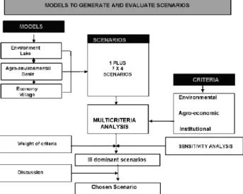
In line with this perspective, and to address the eutrophycation problem of Sete Cidades lake in the Azores, three integrated models (agro-environmental, environmental and economic) are designed to generate efficient land use for more than seven scenarios associated with different degrees of phosphorus emissions. Each one of these plus seven environmental scenarios is associated with different results in the water quality of the lake and with four alternatives of compensatory measures for the farmers and for the community, leading to 29 complete scenarios.
The combination of the three models allows the consistent estimation of various indicators for each scenario. Then a multiobjective program is used to get acceptable weights for each indicator by the stakeholders. The dominant solutions are selected and finally a solution is discussed.
2. Case Study Description and the Decision Problem
The Sete Cidades Lake (437 hectares) is located in the volcanic crater of the São Miguel Island (Azores). The watershed has 1923 hectares, which 25% is covered with water. The remaining areas are pastures (450 hectares), production forests (380 hectares), wild forests (450 hectares) and others, including social areas (160 hectares). Precipitation is 1600 mm per year. Extreme logging and the use of fertilisers in the pastures increased sedimentation and eutrophycation of the water body.
Since the problem was highlighted in the nineties, the regional government undertook a series of measures: land use planning without taking into account the social and economic effects and reactions; introduction of fish to remove the phosphorous and introduction of algae to protect the fish; removal of dead algae to clean the lake with a special boat; attempt to buy the milk quota from the
farmers; attempt to introduce agro-environmental measures without appropriate calibration. Unfortunately none of these measures were effective.
The problem seems to be that those policies never tried to understand the behaviour of the stakeholders. Farmers have 750 cows which produce 3.8 millions of milk per year, provide direct employment to 67 farmers and induce employ-ment to more 50 actives. They sustain 400 persons which represent half of the population of the watershed. On the other hand, these 750 cows generate 600 Kg of phosphorus per year which leads to an increased degradation of the lagoon, probably to a reduction of 15% in tourism (Dentinho et al., 2000) and to negative effects on employment outside the basin of around 250 employees. Intensified dairy production has successively resulted in depletion of the lakes mainly due to unsustainable farming and logging practices. Nevertheless the issue became a public issue when eutrophycation and sedimentation increased strongly in the tourists.
Figure 1 presents the current situation of the Sete Cidades Basin. The land is currently used for intensive dairy farming, which results in deforestation, soil erosion and sedimentation of the lake. The soil erosion increases the flow of nutrients and fertilizers in the Lake which contributes directly to eutrophycation. Until now, the increased sedimentation has resulted in a decrease of the depth
Figure 1. Current land use of Seven Cities Basin
of the lake by 10 meters. Continued sedimentation and eutrophycation will have two major impacts: 1) degradation of the landscape aesthetics and; 2) reduced water quality and availability.
The water flow of the basin is 14 million cubic meters per year. The reno-vation rate of the lake is 20% per year, which leads to an average time for renovation of five years. The average quality of the lake water measured by the Carlson Indicator of the Trophic State(CTS = 40-50), assessed by the trans-parency of the water, the concentration of phosphorus or the concentration of chlorophyll, shows a situation that varies between mesotrophy and meso-eutrophy along the last 10 years. Physical and chemical analysis of the various sub-basins show a close relation between the concentration of phosphorus and nitrogen, the distribution of cattle, and the functioning of the drainage and precipitation systems.
3. Methods
To address this problem (see Figure 2) we identify consistent scenarios and then evaluate them with a multicriteria analytical tool (Bana e Costa, C. et al., 2002). To obtain consistent scenarios, we formulate, calibrate and integrate three models: an environmental model of the lagoon, an agro-environmental model of the basin and an economic model of the village. To evaluate all the scenarios we use a decision support system and select three dominant scenarios based on twelve economic and environmental criteria.
The various scenarios result from the combination of four types of policies: • Preventive measures are related to changes on land use and defined
according to the effect on the emissions to the lagoon.
• Corrective measures involve the deviation of the polluted water to outside the basin and can also be associated with changes in the emissions to the lagoon.
• Social measures are due to compensate the loss of employment in the village that results from the changes imposed on land use.
• And economic measures aimed to compensate the loss of income by the farmers due to changes imposed in the land use.
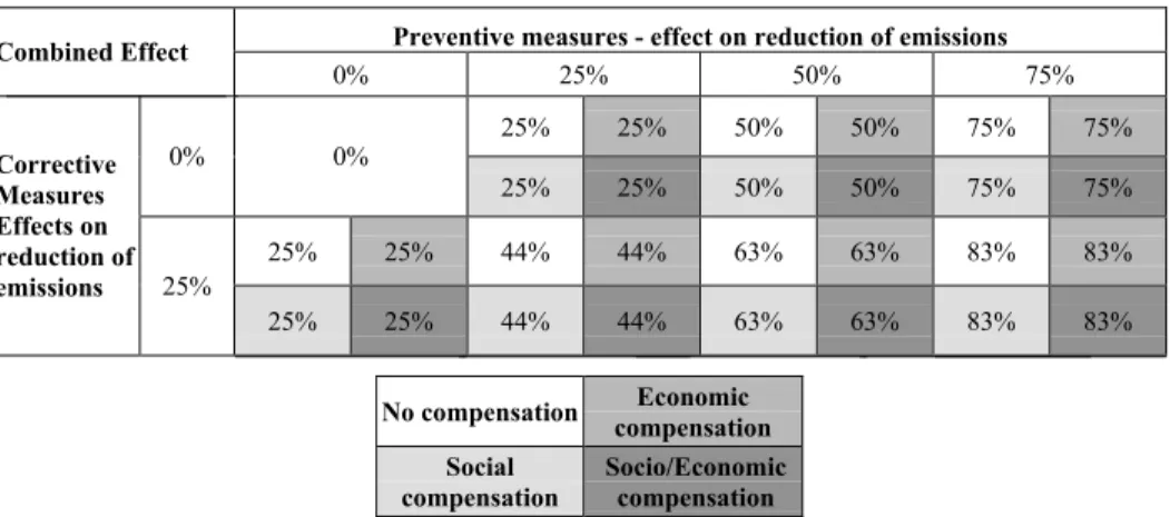
Table 1 presents the 29 scenarios associated with the combination of the measures described above and their effect on the reduction of emissions that reach the lagoon. These scenarios result from the combination of seven environmental alternatives with four alternatives for compensatory policies: a) yes or no to compensate the farmers from income loss; and b) yes or no to compensate the local community from direct and induced decrease in local employment.
The seven environmental scenarios are derived from the combination of corrective measures with preventive measures. The corrective measure taken into account is the construction of a tube to derive 25% of the polluted water from the fields to outside the basin through a discharger tunnel. The preventive measure is the reduction of 25%, 50% or 75% of phosphorus emissions. The 29th scenario is the existent situation.
TABLE 1. Effect of the different scenarios from emissions to the lake Preventive measures - effect on reduction of emissions Combined Effect 0% 25% 50% 75% 25% 25% 50% 50% 75% 75% 0% 0% 25% 25% 50% 50% 75% 75% 25% 25% 44% 44% 63% 63% 83% 83% Corrective Measures Effects on reduction of emissions 25% 25% 25% 44% 44% 63% 63% 83% 83% No compensation compensation Economic
Social compensation
Socio/Economic compensation
To estimate the effects of those scenarios on other environmental and economic indicators we need to formulate, calibrate and simulate the
environ-mental model of the lake, the agro-environenviron-mental model of the basin and the economic model of the village.
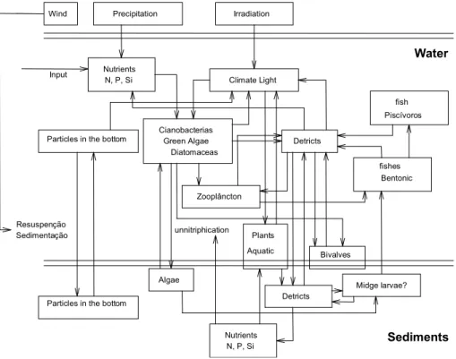
The environmental model of the lake is an adaptation of the model used by AquaSense Grontmi to the conditions of the Sete Cidades Lake. The model is calibrated based on data about the level of phosphate in the lake and phosphate emissions collected in the small streams that reach the lagoon, which accounts for an annual inflow of phosphorus of around 600 Kg per year.
The major problem related to water quality is the growth of cianobacteria and other phytoplankton that, during summer, are responsible for changes in the colour of the lake. It is the inflow of phosphate to the lake and the seasonal changes in the weather conditions that are responsible for the growth of ciano-bacteria and other phytoplankton, during summer, in Sete Cidades lake. Notice that the concentration of phosphorus is acceptable when compared with other lake systems. Wind Water Zooplâncton Detricts Input Nutrients N, P, Si Climate Light Resuspenção Sedimentação Cianobacterias Green Algae Diatomaceas Sediments unnitriphication Bivalves Algae Nutrients N, P, Si Midge larvae? Precipitation Irradiation Piscívoros fish Bentonic fishes Particles in the bottom
Detricts Plants Aquatic
Particles in the bottom
Figure 3. Environmental Model applied to Sete Cidades Lake
The adaptation of the Model used by AquaSense Grontmi (http://www. grontmij.com/) is made by dividing the Sete Cidades lake in three dimension cells. Then, based on the inflow of phosphorus and nitrogen, it is possible to estimate the evolution of the quality of the water across the lake.
This model is used to obtain indicators that quantify the environmental criteria selected in the multicriteria analysis for the different scenarious: the degree of light in the water; and the concentration of clorophile-a.
The agro-environmental model of the basin is based on a linear programm-ing model applied to the azorean dairy farms (Silva, 2001):
• Agricultural activities for low lands were not considered because all the basin is located on medium and high altitudes;
• Land uses were differentiated by type (wild forest, production forest, high pastures, medium pastures, forages and agriculture), by intensity of pastures, forages and agriculture (intensive or extensive), by sub-basin (Cemitério stream and others) and by area (commons, public area, highlands, Cemitério, Romangos, Arrebentões, Cerrado das Freiras, Margens da Lagoa, Bacias Endorreicas and agricultural area around the village);
• Two environmental restrictions were included (soil erosion and emission of phosphorus) for each sub-basin. The technical coefficients for these restrictions were retrieved from an hydrological model (OPUS) (http://www3.bae.ncsu. edu/Regional-Bulletins/Modeling-Bulletin/Opus_sbull.html) calibrated by José Fontes (2000) for the Azores pastures and forages.
• Feed supplement was discriminated by bimestrial and nutritional equili-brium equations were introduced to substitute imposed restrictions on cattle per hectare.
• Furthermore the correction of technical coefficients for lower use of fertilizer were estimated based on the results obtained by João Reis (2002). The variables of the agro-environmental model are:
• X1ij – High pasture area by zone (i) and intensity (j), for all i and j. • X2ij – Medium pasture area by zone (i) and intensity (j), for all i and j.
• X3ij – Forage area by zone (i) and intensity (j), for all i and j. • X4i – Forest area by zone (i), for all i.
• X5i– Wild forest by zone (i), for all i. • X6k – Feed by bimestrial (k), for all k. • X7 – Cows per year
• X8 – Milk per year
• X9 – Other cattle sold per year (in number) • X10k
• X11m
• X12m – Erosion by sub basin (m).
– Phosphorus emissions by sub basin (m) – working hours by bimestrial (k), for all k.
The coefficients of the Objective Function are positive for products (forest, milk and beef) and negative for intermediary products (pastures, forages, feed and labour). All direct subsidies related to the amount produced were included in the coefficients of the Objective Functions.
The following restrictions were taken into account:
• Land restrictions: land uses for high and medium areas must be lesser than the areas available for those altitudes.
• Rotation restrictions: for pastures and forages wheat cannot occupied more tan 20% of the area at medium altitude. And there is no wheat at high altitude.
• Labour restrictions: labour is contracted by bimestrial according to the need for the management of pastures, forages, forests and cattle.
• Nutritional restrictions: dairy cattle with 650 Kg and producing 25 litres of milk per day for 305 days of the year. They need 20% of substitution animals the nutrition components considered by bimestrial were Milk Forage Unities, Digestive Protein, Nitrogen Limits, Calcium and Phosphorus. We also took into account restrictions on feed consumption and the equilibrium between Digestive Protein, Nitrogen Limits and Milk Forages Units.
• Environmental restrictions: these restrictions related each one of the land uses with erosion and phosphorus emissions according to the type of soil that is occupied. The emissions of phosphorus and the erosion were obtained through the simulation of OPUS model, developed by the Agricultural Research Service of the Department of Agriculture of The United States.
The agro-environmental model was calibrated for the Sete Cidades through a small variation in the nutritional needs in order to get the total milk pro-duction of Sete Cidades. Once calibrated it was possible to simulate the eight basic scenarios of the Plan by changing the Right Hand Side of the restriction for phosphorus emissions.
The agro-environmental model generates different land uses. Based on land use we derived an indicator of biodiversity which was used in the multicriteria analysis.
This model is used to obtain indicators to quantify the agro-environmental criteria selected in the multicriteria analysis: Milk production per year; Net value for the economic compensation of the preventive measures; Net value of the social compensation of the preventive measures (employment compensation); Biodiversity; Phosphorus emissions; and Soil erosion.
Objective Function signals - - - + + - 0 0 Variables X1ij X2ij X3ij X4i X5i X6k X7 X8 X9 X10k X11m X12 m High Pas tures Medi um Pastur es Forages Forest Wild Forest
Feed Cows Milk
Other Cattle Labour Emissions Erosi
on Land Restrictions Rotation Restrictions Labour Restrictions Nutritional Restrictions Environmental Restrictions Basic activities produced externally Non Basic activities provided internally Natural resources of Seven Cities c External activities with use of local resources Basic activities produced internally Non basic activities provided externally Population d b a e f g h i j k
Figure 5. Economic System of Sete Cidades
The model for the local economy is represented in Figure 5. The idea is that the economic system of the village explained by a Base Model (Costa, J.S. et al., 2002), relates to the natural resources of the basin through the arrows: g,h,i,j,k.
Furthermore the coefficients a,b,c,d,e can be integrated in a model to esti-mate the multiplier effects of changes in the basic activities of the village (dairy
This model is used to obtain indicators to quantify the economic criteria selected in the multicriteria analysis: Number of vehicles that reach the village based on the change in the tourist attraction of the basin; change in the built area which is related to the number of extra jobs created in the tourist sector to compensate the loss in the agricultural sector; number of persons per house which is estimated according to the number of jobs generated by each scenario and the number of houses available; number of students that must go to a school outside the village which is a result of the social compensatory measures and the change in the population; number of second houses which derives from the changes in the economic tissue of the village; and number of actives with an employment in the village.
The method proposed to evaluate and compare the alternative scenarios for the Sete Cidades basin is the Multicriteria Decision Support System
.
TABLE 2. Multiplier Effects on the Employment and Population
Employment multiplier 1.75
Population multiplier 5.84
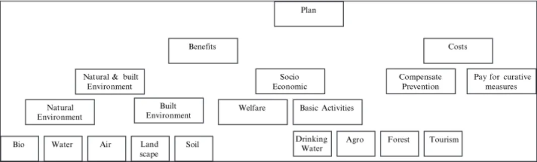
The criteria and their hierarchy presented in Figure 6 was established through a dialogue with the main stakeholders (regional, local and communal entities, farmers’ association and NGOs).
To operate these criteria it is necessary to choose an impact descriptor for each one of them. The descriptor can be direct or constructed, quantitative or qualitative, continuous or discrete. Once we have a descriptor associated to each criteria j (j = 1, …, n), it is possible to identify a profile of impacts (g1(a), …, gj(a), …, gn(a)) for each alternative scenario.
Figure 6. Hierarchy of Evaluation Criteria
production,…) in the total employment and total population of the village (Table 2).
Plan
Natural & built Environment Costs Benefits Socio Economic Natural Environment Built Environment Bio Water Air Land
scape Soil
Welfare Basic Activities
Agro Forest Tourism Drinking
Water
Compensate Prevention
Pay for curative measures
g1(a) Criterium 1
Profile of Impacts of Alternative a
Criterium 2 Criterium 3 Critérium 4 g2(a) g3(a) g4(a) g1(a) g2(a) g3(a) g4(a)
Figure 7. Impacts of Alternative a
Figure 7 illustrates the profile of impact for scenario a in a hypothetical situation involving four criteria. The descriptors for criteria 1 and 3 have a continuous scale whereas the descriptors for criteria 2 and 4 have discrete scale.
After that it is possible to define the weights of each criteria based on “Trade off procedure”, to undertake the global evaluation of the various scenarios and to proceed to the sensitivity analysis.
4. Results
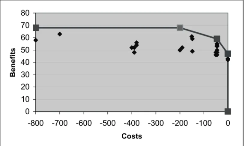
With the three models we get a table of 14 impacts descriptors for each one of the 29 alternative scenarios. With the multicriteria analysis we obtain a selection of the dominant scenarios (Figure 8).
0 10 20 30 40 50 60 70 80 -800 -700 -600 -500 -400 -300 -200 -100 0 Costs Benefits
Figure 8. Dominant Scenarios
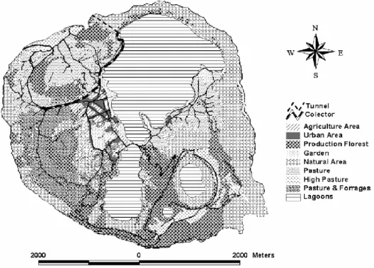
The scenario chosen accounts for 600 cows that produce 3.0 million litres of milk and provide direct employment to 53 farmers and induced employment to more 40 actives. Furthermore the deviation of one of the main water streams
Figure 9. Land Use Plan
that feeds the lagoon will allow a reduction of 63% of the phosphorus load on the lagoon. Compensatory measures, economic and social, will compensate the farmers for their losses and the community for the lost basic employment. The land use plan associated with the chosen scenario is presented in Figure 9.
5. Conclusion and Future Developments
The issue of the eutrophycation of the Sete Cidades Lake in São Miguel show that it is not possible to promote integrated water management without considering the process of land users’ decision makers. Mostly because most of the rural community depend on the land use and the generation of the purest water will lead to the end of that community.
Furthermore there is a need to improve the quality of the links between the various models. Actually, the global model was not designed a priori but resulted from the integration of three already developed models. The connections between assume some type of transformation between working hours and employment. On the other hand the link between the agro-environmental model and the the economic model of the village and the agro-environmental model had to
environmental model of the lake had to assume some transformation between the emissions from the land into inputs into the lake. Finally the results of the multicriteria analysis could be compared with the outcome from a pure cost-benefit analysis.
Acknowledgements
Part of the results of this work has been presented and discussed in the CCMS-NATO meeting of Genova.
Thanks to all the “Gabinete de Gestão e Conservação da Natureza” Joana Gonçalves, Luisa Calado, Vanda Serpa and Vasco Silva.
References
Bana e Costa C.A., De Corte J.-M., Vansnick J.-C, 2002, Multiple Criteria Decision Analysis: International Series in Operations Research & Management Science, 76: 409-442. (Preprint: Working Paper LSEOR 03.61 2003, London School of Economics).
Bazzani, G.M., 2005, An integrated decision support system for irrigation and water policy design: DSIRR Environmental Modelling & Software, 20: 153-163.
Bazzani, G.M. S. Di Pasquale, V. Gallerani, S. Morganti, M. Raggi, D. Viaggi, 2002, Environmental Modelling & Software, 20: 165-175.
Compêndio de Economia Regional. Associação Portuguesa de Desenvolvimento Regional. Dentinho, T., Etienne Lamy and Gorm Dige, 2000, Managing environmental trade-offs between
recreational uses and agriculture: the case of the Seven Cities Lake in São Miguel Island. In Perspectivas de Desenvolvimento para as Regiões Marítimas, Actas do VII Encontro da APDR, APDR. 787-800.
Fontes, J.C. 2002, Comportamento hidrologico dos solos agricolas da Terceira: avaliacao e simulacao com o modelo OPUS. Tese de doutoramento da Universidade dos Açores. (2000). Reis, J.C., 2002, Função de Produção Territorial de Leite com Base em Redes Neuronais. Tese de
Mestrado em Gestão e Conservação da Natureza. Universidade dos Açores.
Silva, E., 2001, Análisis Multicriterio de la Eficiencia económica de las Explotaciones Agroganaderas de las Azores, Tesis doctoral, Universidad de Córdoba.
The State of the Art Surveys, Figueira, S. Greco, M. Ehrgott (eds.), J Springer, Book Series: