Proceedings
ISBN 978-989-8780-07-2
25
th
APDR Congress
26
th
APDR Congress
ISBN 978-989-8780-07-2
Welcome to the 26
th
APDR Congress, July 4-5, 2019, Aveiro
APDR and the Local Organising Committee wish you a pleasant and inspiring
participation!
Table of Contents
TABLE OF CONTENTS ... 1
PROGRAMME OVERVIEW ... 2
OVERVIEW PARALLEL SESSIONS ... 3
THEMES ... 4
Umbrella Theme ... 4
General Themes ... 4
Special Sessions’ Themes ... 5
COMMITTEES ... 6
ORGANIZATION ... 6
CONGRESS VENUE ... 7
How to arrive at the University of Aveiro ... 7
DAY BY DAY PROGRAMME ... 8
Wednesday, 3 July 2019 ...9
Thursday, 4 July 2019 ... 10
Friday, 5 July 2019 ... 18
ABSTRACTS AND PAPERS ... 24
Parallel Sessions (1) ... 25
Parallel Sessions (2) ... 98
Parallel Sessions (3) ... 416
Parallel Sessions (4) ... 748
26
th
APDR Congress
ISBN 978-989-8780-07-2
108
01173 - USE OF DIFFERENT OPTIMIZATION ALGORITHMS TO DEFINE
SERVICE AREAS OF POLICE STATIONS IN PORTUGAL
André Duarte
1, Roberto Henriques
2, Sara Ribeiro
31 NOVA IMS Information Management School, Universidade Nova de Lisboa, Lisboa 1070-312, Portugal, g2016040@novaims.unl.pt 2 NOVA IMS Information Management School, Universidade Nova de Lisboa, Lisboa 1070-312, Portugal, roberto@novaims.unl.pt 3 NOVA IMS Information Management School, Universidade Nova de Lisboa, Lisboa 1070-312, Portugal, sribeiro@novaims.unl.pt
Abstract. Security is considered a fundamental right in democratic societies. Nowadays security forces reorganization
depends on the population distribution and dynamics. The spatial disposition of security forces and the corresponding adequacy of resources benefit from the use of advanced spatial analysis tools. In order to provide better police service, it is necessary to divide the territory into areas or contiguous geographic clusters, which criteria may be having the same population, a similar crime rate, or balanced agent workloads. The process of grouping small geographic areas in service areas is called districting or zone design. The main objective of this work is the spatial optimization of the distribution of security forces considering the spatial disposition of the population in Setubal administrative district. In this paper, a genetic algorithm metaheuristic that addresses the police redistricting problem is proposed. The process of grouping areas into service areas was subject to constraints of population equality, contiguity and compactness. Data analysis was done with the hot spot analysis to study the population and their distribution at freguesia level. A genetic algorithm was implemented to create service areas (also known r-districs) and experimental analyses were performed with the population data and vulnerable groups. The simulations were made on 55 freguesias for 28 service areas. We compared the results with the Automatic Zoning Procedure - Simulated Annealing (AZP-SA). The population concentrates in Setubal peninsula, denoting a great asymmetry on their geographical distribution. Experimental tests with the genetic algorithm show a large variation of a sum of the population differences in service areas. Genetic algorithm presented on average 30402 inhabitants per service area. In the other hand, AZP-SA average was 29980. As regards the group with more than 65 years, both algorithms present on average 5599 inhabitants. The lowest compactness values were obtained with AZP-SA in all tests performed. The absence of disaggregated data such as the number of crimes, geographical position of criminal incidents, the number of agents in the service, the number of cars per district were found as a drawback in our analysis. However, it is possible to simulate districts only with population data. The difficulty to obtain equitable areas is due to the great asymmetry of the population.
Keywords. Police Stations, Optimization, Genetic Algorithms, Service Areas, Districting, AZP-SA
1. INTRODUCTION
In the current context of threats and risks to internal security (Rodrigues, 2010), the national strategy for security needs a new paradigm. The population dynamics compel to the security forces reorganization (Weiner and Russell, 2001), at the resources level and spatial distribution.
The security forces distribution in Portugal is still based on the 1990s demographic criteria, so the need for revision is unequivocal (Painho and Ribeiro, 2018). The service areas were designed considering the freguesias and bairros (Henriques et al., 2018). Important metrics such as police/citizen ratios practiced (Oliveira, 2006) should be updated and reviewed in order to establish a better police service. According to Rodrigues et al. (2008), the social, economic, and political changes that have occurred since the mid-twentieth century promoted a great asymmetry in the territory. The migratory phenomena caused a significant difference between coastline and interior of the country in the resident population. Although, the over 65 years old group is growing in the interior, and a younger age group is decreasing. It is required a more effective distribution of security forces (Cabral et al., 2018).
The major concerns of the security forces are the delimitation of service areas. There is a need to define a territorial distribution strategy and operations management to minimize operational costs (Henriques et al., 2018). Service areas for a given objective are called districting or zone design. Districting consists of dividing a geographical region into subregions (Bucarey et al., 2015). Depending on the motivation, different criteria are used to design service areas, namely, population equality, geographical contiguity, and compactness (Bação et al., 2005).
Currently, the major difficulty to implement our strategy and modelling the problem is the absence of disaggregated data such as the number of crimes, geographical position of criminal incidents, the number of agents in the service, and the number of cars per district (Ribeiro, 2018). Despite this gap it is possible to plan the service areas based on population data at freguesia level, although with several limitations.
In this paper, it is presented a literature review on the police service areas and methodological approaches. A hot spot analysis is performed to study total population and vulnerable groups and their distribution. Consequently, we will present a proposal to the police service areas based on metaheuristic genetic algorithm. The major objective is the spatial optimization of security forces distribution considering the spatial disposition of the population in Setubal administrative district. It will be performed a comparison with the AZP-SA (Duque et al. 2011) solutions.
26
th
APDR Congress
ISBN 978-989-8780-07-2
2. LITERATURE REVIEW
Districting is the process of grouping small geographic areas into large districts or clusters (Kalsics, 2015). This process has been applied in political districting (Bação et al., 2005; Bozkaia, 2003), emergency services (Blais et al., 2003 and Baker et al. 1989), police districting (D’Amico et al., 2002) school districting (Ferland and Guénette, 1990), sales regions (Zoltners and Sinha, 1983 and Salazar-Aguilar et al.,2011), among others.
Typically, the most common works in literature are applications to political or electoral districting, which is the problem of dividing a governmental or administrative area into constituencies from which political candidates are elected (Kalsics, 2005). Usually, the concepts of population equality, contiguity, and compactness are presented in electoral districting to avoid the historical phenomena called “gerrymandering”, which are criteria to design districts (Levit and Wood, 2010). The concept of population equality refers to the principle of “one man-one vote”, i.e., all districts should contain approximately the same number of voters (Kalsics et al., 2005). When related to police districting this attribute could be workload or demand, total district area or average response time (Kistler, 2009). Essential constraints are geographical contiguity which are based on contiguous districts or quadrants, to prevent the gerrymandering and reduce travel distances. Compactness measures can be considered as compacted shapes, based on a perimeter-area ratio. D’Amico et al. (2002) refer that when these measures are combined, they determine the effectiveness of a specific problem. The major difference between police districting and other applications is an additional consideration for patrol officer workloads and response time to service calls.
2.1 Police districting problem
D’Amico et al. (2002) refer that the hierarchical structure is composed of command districts (precincts), patrol sectors (beats) and reporting districts (r-districts). Command districts are subdivided into patrol sectors and r-districts which constitute the smallest geographic element in which crime statistics are processed. According to Sarac et al. (1999), r-districts can correspond to small census block groups and are delimited according to physical elements such as avenues, streets, motorways, and rivers.
We have considered previous works on police districting approaching the balance and districts shape constraints. For instance, Mitchel (1972) proposed an optimization model to design car patrol based on the average of weighted distance defined by the sum of service and travel time, using the min-max clustering heuristic. Sarac et al. (1999) discuss the formulation of a multiobjective partition problem and present a practical application based on the classification of census blocks groups. Due to the unsatisfactory performance of the optimization algorithm, they abandoned the idea of police districts in the city of Buffalo, New York.
D'Amico et al. (2002) proposed new limits of command in the city of New York, Buffalo Police Department, through the simulated annealing metaheuristic. The authors used graphs of the partitions that surrounded the command area. The graphs were subject to constraints of contiguity, compactness, convexity, and equal size and response time. After each iteration of the algorithm, the Patrol Car Allocation Model (PCAM) was applied to find the patrol cars optimal allocation. Curtin et al. (2005) used a maximum covering model whose objective is to maximize the number of events that are closer to the center of the facility.
Zhang & Brown (2013) present a Constraint-based Polygonal Spatial Clustering method to solve the police patrol districting problem of the Charlottesville Police Department. This method was assessed with an agent-based model. Cammacho-Collados et al. (2015) defined a multicriteria method with the National Police Corps for the PDP to delineate and characterize the partitions of police departments according to their jurisdiction and hierarchical structure. In the first model, they considered area, risk, compactness, and mutual support attributes. Decision analysis was supported by decision makers preferences regarding attributes, workload balance, and efficiency.
A methodology named Street-Network Police Districting was proposed by Chen et al. (2018), in which the streets were used as basic units. Linear programming and heuristics were performed to solve the problem.
Finally, Henriques et al. (2018) proposed an optimization model for distribution the security forces in mainland Portugal based in a geometric semantic genetic programming system. This method followed the electoral redistricting problem by Castelli et al. (2015).
2.2 Genetic Algorithms
Genetic algorithms (GA) are biologically inspired algorithms for adaptive search methods and optimization problems, and machine learning (Goldberg, 1989; Costa and Simões, 2008). These algorithms are based on Darwin's theory of evolution. Initially, the population is generated randomly. Each individual in the population represents a candidate solution (Mitchel, 1998). The population will evolve over generations through the performance of selection mechanisms such as recombination and mutation operators. The best individuals are chosen based on an evaluation function (fitness function). Its reproduction consists in the exchange of genetic material between the progenitors that will give rise to the descendants. The mutation may still cause changes in individuals. There are several types of genetic operators. The user’s
26
th
APDR Congress
ISBN 978-989-8780-07-2
110
choice is very important because it allows the algorithm to explore the global search space (Costa and Simões, 2008). Genetic algorithms have the advantage of handling very specific tasks and are adjustable to difficult resolution problems. We can find in the literature works with genetic algorithms such as Hosage and Goodchild (1986), that presents the first research in the spatial optimization area using a GA to solve localization-allocation problems. Another example is Bação et al. (2005), where a political districting problem is solved with a genetic algorithm.
3. MATERIALS AND METHODS
3.1 Study area
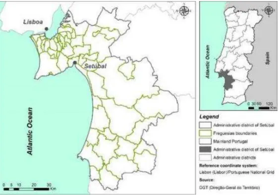
The study area is the administrative district of Setúbal located in the south of Portugal's capital, Lisbon. It has a total area of approximately 5214 km2 and consists of 13 municipalities and 55 freguesias (parishes) according to the new
administrative reorganization. Figure 1 shows the geographic location of the study area and the respective boundaries of the freguesias.
In 2017, according to the projections of INE5 (2018) and PORDATA6 (2018), the population of the capital of the district
was 116,330 inhabitants. The district has a total population of 851,258 inhabitants according to the 2011 census (INE, 2014).
Figure 1 - Geographic location of the study area
3.2 Data collection and exploratory analysis
The data collection and analysis were carried out at the freguesia level. The census data was collected on the website of the National Statistics Institute (INE). We aggregated the data according to the new administrative reorganization provided by the Carta Administrativa Oficial de Portugal (CAOP). In order to analyse the population data, we create two different datasets, where the first contained the resident population and the second the resident population over 65 years old.
Hot spot analysis, also known as Getis-Ord Gi* test, was performed to study the total population, and age group concentration and distribution. We applied the hot spot analysis tool of ArcGIS to boundaries of freguesias layer.
3.3 Districting model: definition and constraints
As we mentioned above criteria depend on the motivation of the problem. The proposal problem statement is based on Bação et al. (2005) and Castelli et al. (2015) districting models. The constraints of the districting problem are similar to the clustering problem. The problem can be formulated with the following characteristics:
- Population balance, where all districts must be equal in terms of population;
5 INE – Instituto Nacional de Estatística (National Statistics Institute)
26
th
APDR Congress
ISBN 978-989-8780-07-2
- Contiguity, each district should be a single and contiguous territory; Geographic compactness, districts should be compact;
- Population equality was assessed by the sum of the differences between the district population and the average population of all districts.
Bação et al. (2005), share the following objective function, where Pj represents the population of the jth service area and
µ the average population per service area.
min
|
j|
j
P
(1)
The population equality produces thin and long service areas, that will be difficult to manage the workloads and the travels between incidents. Radial compactness is an important constraint because is defined by the sum of all service areas, of the sum of Euclidean distances between the centroids of its service area and the center of that service area. Euclidean distance between the ith service area and jth the center of the service area is represented by dij:
j ij j i Z
RadialCompactness
d
(2)The compactness measure can be included in the objective function through the sum:
min
(|
|
)
j j ij j i ZP
d
(3) On the other hand, compactness can be calculated with the sum of the ratios between the square of the perimeter of each zone and its the area. Where pri2 is the square of perimeter of service area i, and ai is the area of the service area.2 i i i
pr
a
(4) This approach verifies that the contiguity restriction is respected. A method used to verify the contiguity was a U-matrix built with Pysal library.AZP-SA regionalization model (Openshaw & Rao, 1995) was used in order to compare the solutions. This model uses equation 1 to perform the solutions and use polygons instead of points. Clusterpy (Duque et al., 2011) was used to perform the algorithm.
3.4 The proposed genetic algorithm
The first step to be considered is the encoding of solutions. Our proposal is similar to the p-median problem. Each centroid of the freguesias was coded as a string with length k, where k is the number of service areas, and the ith element of the string is the position of the center of the ith service area. It was used 55 freguesias for 28 service areas, then the chromosome size is 28 genes. Dictionary of lists were used to represent the center of each service area, for instance {'C': ['A', 'Z', 'D'], 'F': ['W', 'H', 'U', 'T']}, where C and F are the center.
The genetic algorithm is randomly initialized through to relations of first-order neighbouring. U-matrix was used to perform the neighbouring relations. The initial population was 100 each one with 28 strings. Equations 1 and 3 were used to compute the fitness function.
The process of selecting parents which mate and recombine to create off-springs for the next generation was done with rank selection by descending order of the fitness function values. The random one-point crossover was used with a 100% rate. In order to introduce diversity in solutions was applied to the mutation genetic operator. The mutation rate was 1%. Finally, the stopping criterion consisted of the ending the algorithm after 500 generations.
We perform 150 tests with different parametrizations with the objective to find potential premature convergence. The genetic algorithm was implemented through pure python programming. Pysal library was used to produce the U-matrix.
4. RESULTS AND EXPERIMENTAL SETTINGS
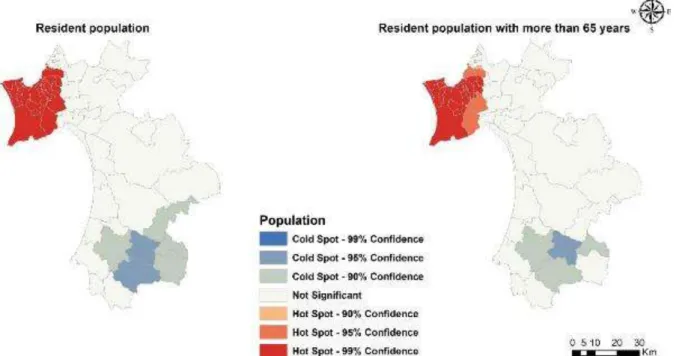
4.1 Hot spot analysis
Figure 2 shows the freguesias that constitute hot spot and cold spot concerning the resident population and the population over 65 years old. The resident population is concentrated mainly in the Setúbal peninsula as we can observe in Figure 2 (left). The cold spot is located in the south, with special emphasis to the freguesia of Abela and the União de Freguesias de São Domingos e Vale de Água.
26
th
APDR Congress
ISBN 978-989-8780-07-2
112
Concerning the population over 65 years old, it is found that its concentration is higher in the Setúbal peninsula, except for the Sesimbra freguesia which is not statistically significant (Figure 2 right). Abela is the freguesia with the most significant cold spot.
Figure 2 - Hot spot analysis with Resident population data (left) and population over 65 years (right).
This analysis shows that there is a great asymmetry in the population distribution, which makes difficult to plan and allocate service areas.
4.2 Experimental results
4.2.1 Resident population
Table 1 summarizes the results of the genetic algorithm and the AZP-SA for the resident population by freguesia. Regarding the average of inhabitants of the service areas of equations 1 and 3, it was found that they are similar (30402 inhabitants). The AZP-SA was obtained as a lower average, with 29981 inhabitants. The standard deviation to the mean is low in the AZP-SA with 22138 inhabitants. On the other hand, the worst result was obtained by equation 3. These results show that the AZP-SA performs better than the genetic algorithm. Here, it was clear the difficulty in obtaining population equitability due to the large asymmetry of the resident population.
Table 1 - Summary of the results of the service areas for the resident population
Equation 1 Equation 3 AZP-SA
Average 30402,1 30402,1 29980,6
Median 20664 14125 33653,5
Standard deviation 29239,8 34600,5 22138,5
Minimum 890,0 890,0 450,0
Maximum 115877,0 115683,0 96290,0
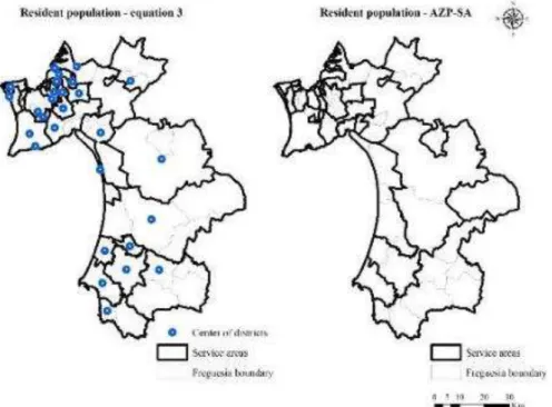
Figure 3 and 4 show the concentration of service areas in Setubal peninsula compared to the south of the administrative district. On the left, it is possible to observe an unexpected design of service areas due to the strong neighbourhood restrictions implemented. We expected to enclose circular or rectangular shapes. One of the reasons for this phenomenon is the strong restriction in the positioning service areas center. Another reason for these results is the great asymmetry of the resident population as we refer above. Bação et al. (2005), for the electoral districting problem, obtained more enclosed shapes and they refer the worst performance of the AZP-SA.
26
th
APDR Congress
ISBN 978-989-8780-07-2
Figure 3 - Service areas design with equation 1 for dataset 1
As regards to AZP-SA, it was expected to obtain fewer compact forms, because the compacity was not included as a constraint (Figure 4 on the right).
Figure 4 - Service areas design with equation 3 (left) and AZP-SA solution (right), both dataset 1
4.2.2 Population over 65 years old
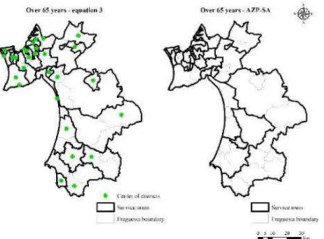
Table 2 summarizes the results of the genetic algorithm and the AZP-SA to the vulnerable group of the population over 65 years. Equation 3 and AZP-SA have the same average (5599.8), the deviations are greater with equation 3.
Table 2 - Summary of the results of the service areas for the population over 65 years old.
Equation 3 AZP-SA
Average 5599,8 5599,8
Median 3696,5 4580,0
Standard deviation 5278,6 4345,0
26
th
APDR Congress
ISBN 978-989-8780-07-2
114
As shown in Figure 5, an unexpected design of service areas was found as we refer above. In this case, the AZP-SA obtained oblong forms.
Figure 5 - Service areas design with equation 3 (left) and AZP-SA solution (right), both dataset 2
4.3 Comparison of the sum of population differences and compactness
Compactness to the resident population of the lowest value was obtained with equation 2 (1332.7) and the AZP-SA (1332.9). The lowest sum of population differences was obtained with the AZP-SA (501,320.7). The AZP-SA has lower compactness which means that features have more compact forms than the GA. The same happened to the population over 65 years old. The values of the sum of population differences with the AZP-SA were minimized (75691.5). Concerning the compactness, the lowest values were obtained with AZP-SA.
Table 3 - Comparison of results obtained
Dataset Algorithms Compactness Sum of population differences Resident population Equation 1 1351,4 678070,4
Equation 2 1332,7 789786,9 AZP-SA 1332,9 501320,7
Over 65 years Equation 3 1387,3 114030,5 AZP-SA 1372,3 75691,5
Nevertheless, these results are very encouraging although in our opinion some adjustments are required to solve the problem with genetic algorithm.
5. CONCLUSIONS AND FUTURE WORK
The main objective of this work was the spatial optimization of the distribution of security forces considering the population spatial disposition in Setubal administrative district. A genetic algorithm was implemented to create service areas and experimental analyses were performed with the population data and vulnerable groups. The simulations were made on 55 freguesias for 28 service areas. Results were compared with the Automatic Zoning Procedure - Simulated Annealing.
The great spatial asymmetry within the Setubal district population was the main drawback found. This fact was verified with hot spot analysis. This asymmetry makes it difficult to locate-allocate public services. Overall, this is an example of the Portuguese reality. The population is more concentrated on the coast than in the interior. When regards to security forces, this bring other concerns, since the countryside is now populated with elderly citizens, in very remote areas, living alone or with other elders, which makes these population group very vulnerable.
The development of different algorithms to create service areas for police stations has been implemented although there are some criteria and constraints to be improved. The GA allowed defining the service areas according to the established criteria. However, AZP-SA performance in solving this optimization problem was slightly higher with the tests performed. Increasing the search space of the GA is expected to improve the performance of the genetic algorithm.
In the future, we will test different encoding and neighbourhood relations to improve GA performance. On the other hand, the next step will be to apply GA and other metaheuristics to mainland Portugal.
26
th
APDR Congress
ISBN 978-989-8780-07-2
Acknowledgments
The authors would like to thank the SIM4SECURITY – Forecast and Spatial Analysis Model for Public Security Project.
REFERENCES
Bação, F., Lobo, V., & Painho, M. (2005). Applying genetic algorithms to zone design. Soft Computing, 9(5), 341–348.
Baker, J. R., Clayton, E. R., & Moore, L. J. (1989). Redesign of primary response areas for county ambulance services. European Journal of Operational Research, 41(1), 23–32.
Blais, M., Lapierre, S. D., & Laporte, G. (2003). Solving a home-care districting problem in an urban setting. Journal of the Operational Research Society, 54(11), 1141–1147.
Bozkaya, B., Erkut, E., & Laporte, G. (2003). A tabu search heuristic and adaptive memory procedure for political districting. European Journal of Operational Research, 144(1), 12–26.
Bucarey, V., Ordóñez, F., & Bassaletti, E. (2015). Shape and Balance in Police Districting. In Applications of Location Analysis, Santiago, Chile: Springer International Publishing Switzerland, 329-347.
Cabral, P., Ribeiro, S., Pereira, J., & Painho, M. (2018). Análise espacial avançada no contexto da segurança interna. In Modelos Preditivos & Segurança Pública, Porto: Fronteira do Caos, pp. 231–251.
Camacho-Collados, M., Liberatore, F., & Angulo, J. M. (2015). A multi-criteria Police Districting Problem for the efficient and effective design of patrol sector. European Journal of Operational Research, 246(2), 674–684.
Castelli, M., Vanneschi, L., Henriques, R., (2015). A geometric semantic genetic programming system for the electoral redistricting problem. Neurocomputing., 154, pp.200-207.
Chen, H., Tao Cheng & Xinyue Ye (2018): Designing efficient and balanced police patrol districts on an urban street network, International Journal of Geographical Information Science.
Costa, & Simões. (2008). Inteligência Artificial - Fundamentos e Aplicações (2.a edição). FCA edições.
Curtin, K. M., Hayslett-McCall, K., & Qiu, F. (2010). Determining optimal police patrol areas with maximal covering and backup covering location models. Networks and Spatial Economics, 10(1), 125–145.
Curtin, K. M., Qui, F., Hayslett-McCall, K., & Bray, T. M. (2005). Integrating GIS and Maximal Covering Models to Determine Optimal Police Patrol Areas. In F. Wang (Ed.), Geographic Information Systems and Crime Analysis, Hershey, PA: IGI Global. pp. 214-235. D’Amico, S., Wang, S.-J., Batta, R., & Rump, C. (2002). A Simulated Annealing Approach to police district design. Computers & Operations
Research, 29 (1999), 55–65.
Duque, J. C., Dev, B., Betancourt, A., & Franco, J. L. (2011). ClusterPy: Library of spatially constrained clustering algorithms, Version 0.9.9., Colombia, Retrieved October, 2018, from http://www.rise-group.org.
Ferland, J. A., & Guénette, G. (1990). Decision Support System for the School Districting Problem. Operations Research, 38(1), 15–21. Goldberg, D. (1989). Genetic Algorithms in Search, Optimization, and Machine Learning (First). Addison-Wesley Publishing Company. Henriques, R., Ribeiro, S., & Castelli, M. (2018). Modelo de otimização. In Modelos Preditivos & Segurança Pública, Porto: Fronteira do
Caos, pp. 291–302.
Hojage, C. & Goodchild, M. (1986). Discrete space location-allocation solutions from genetic algorithms. Annals of Operations Research, 2, 35-46.
INE (2014). Censos 2011 -População residente por freguesia, CAOP 2013, Retrieved October, 2018, from https://censos.ine.pt/xportal/xmain?xpid=CENSOS&xpgid=censos_quadros.
INE (2018). Estimativas da População Residente em Portugal-2017. Retrieved October, 2018, from, https://www.ine.pt/xportal/xmain?xpid=INE&xpgid=ine_destaques&DESTAQUESdest_boui=315156710&DESTAQUESmodo=2. Kalcsics, J. (2015). Districting Problems. In Location Science, Karlsruhe: Springer International Publishing Switzerland. pp. 595–622 Kalcsics, J., Nickel, S., & Schröder, M. (2005). Towards a unified territorial design approach - applications, algorithms, and GIS
integration. Top, 13(1), 1–56.
Kistler, A. (2009). Tucson Police Officers Redraw Division Boundaries to Balance Their Workload. Geography & Public Safety, 1(3), 1– 2. Retrieved October 2018, from https://ric-zai-inc.com/Publications/cops-w0550-pub.pdf%0Ahttp://www.nij.gov/topics/technology/maps/documents/gps-bulletin-v1i3.pdf.
Levit, J., & Wood, E. (2010). A citizen’s guide to redistricting (New York U) Retrieved October, 2018, from https://www.brennancenter.org/page/-/CGR%20Reprint%20Single%20Page.pdf.
Mitchell, P. (1972). Optimal Selection of Police Patrol Beats. The Journal of Criminal Law, Criminology and Police Science, 63(4). Mitchell, M. (1998). An Introduction to Genetic Algorithms. Cambridge, Massachusetts: MIT Press Cambridge, ISBN: 0262631857. Oliveira, J.F.(2006). As políticas de Segurança e os Modelos de Policiamento – A emergência do Policiamento de Proximidade, Coimbra,
Edições Almedina.
Openshaw, S., & Rao, L. (1995). Algorithms for reengineering 1991 Census geography, 27(April 1994), 425–446.
Painho, M., & Ribeiro, S. (2018). O projeto SIM4SECURITY. Um exemplo de aplicação de tecnologias diferenciadas em sede de políticas públicas. In Modelos Preditivos & Segurança Pública, Porto: Fronteira do Caos, pp. 157–167.
PORDATA (2018). Base de dados de Portugal contemporâneo. URL: https://www.pordata.pt/, consultado em outubro de 2018. Ribeiro, S., & Henriques, R. (2018). Aplicação dos Self-organizing Maps na análise da criminalidade em Portugal, 2011, 2016. In Modelos
Preditivos & Segurança Pública Porto: Fronteira do Caos, pp. 253–280.
Rodrigues, T. (2008). História da População Portuguesa. Das longas permanências à conquista da modernidade. Porto: Afrontamento, CEPESE.
Salazar-Aguilar, M. A., Ríos-Mercado, R. Z., & González-Velarde, J. L. (2011). A bi-objective programming model for designing compact and balanced territories in commercial districting. Transportation Research Part C: Emerging Technologies, 19(5), 885–895. Sarac, A., & Batta, R. (1999). Reconfiguring Police Reporting Districts In The City of Buffalo. O.R. Insight, 12(3), 16–24.
Weiner, M., Russell, S.(eds) (2001). Demography and National Security, Nova York, Oxford, Berghan Books.
Zhang, Y., Brown, D. (2013). Police patrol districting method and simulation evaluation using agent-based model & GIS. Security Informatics, 2(7),pp.1-13.