1
UNIVERSIDADE FEDERAL DO PARÁ
INSTITUTO DE GEOCIÊNCIAS
PROGRAMA DE PÓS-GRADUAÇÃO EM GEOLOGIA E GEOQUÍMICA
TESE DE DOUTORADO Nº 97
DESENVOLVIMENTO DA VEGETAÇÃO E MORFOLOGIA
DA FOZ DO AMAZONAS-PA E RIO DOCE-ES DURANTE O
QUATERNÁRIO TARDIO
Tese apresentada por
:MARLON CARLOS FRANÇA
Orientador: Prof. Dr. Marcelo Cancela Lisboa Cohen (UFPA)
Coorientador: Prof. Dr. Luiz Carlos Ruiz Pessenda (CENA/USP)
Dados Internacionais de Catalogação-na-Publicação (CIP) Sistema de Bibliotecas da UFPA
F798d França, Marlon Carlos
Desenvolvimento da vegetação e morfologia da foz do Amazonas-PA e rio Doce-ES durante o Quaternário tardio / Marlon Carlos França; Orientador: Marcelo Cancela Lisboa Cohen; Co-orientador: Luiz Carlos Ruiz Pessenda – 2013
Tese (doutorado em geologia) – Universidade Federal do Pará, Instituto de Geociências, Programa de Pós-Graduação em Geologia e Geoquímica, Belém, 2012.
1. Sedimentologia – Pará. 2. Sedimentologia – Espírito Santo. 3. Estratigrafia. 4. Palinologia. 5. Quaternário. 6. Planícies de mare. I. Cohen, Marcelo Cancela Lisboa, orient. II. Universidade Federal do
Pará. III. Título.
V
niversidade Federal do Pará
9!1iil!~
Instituto de Geociências
Programa de Pós-Graduação em eologia e Geoquímica
DESENVOLVIMENTO DA VEGETAÇÃ E MORFOLOGIA
DA FOZ DO AMAZONAS-PA E RIO DO E-ES DURANTE O
QUATERNÁRIO TARD O
TESE APRESENTADA PO
MARLONCARLOSFRA ÇA
Como requisito parcial à obtenção do Grau de Doutor em Ciê cias na Área de GEOLOGIA
Data da aprovação: 05/11/2013
AGRADECIMENTOS
Expresso aqui meu total agradecimento a Deus, por toda força e proteção que tem me concedido durante todos os dias da minha vida e, à minha família, por todo apoio e honestidade.
Agradeço ao meu orientador Prof. Dr. Marcelo Cancela Lisboa Cohen (UFPA), co-orientadores Prof. Dr. Luiz Carlos Ruiz Pessenda (USP) e Prof. Dr. Raymond S. Bradley (UMASS/Amherst), por todo o conhecimento científico e social transferido, por todas as discussões e sugestões, além dos incentivos diários para a composição deste e dos futuros trabalhos.
Aos amigos do PPGG e Biblioteca do Instituto de Geociências da UFPA, Cleida Freitas, Lúcia de Sousa e Hélio.
Aos Professores Dra. Dilce de Fátima Rossetti (INPE), Dr. Paulo C. F. Giannini (USP), Dr. Jolimar A. Schiavo (UEMS), Dra. Susy Eli Marques Gouveia e ao Dr. Franklin N. Santos pela amizade, por toda orientação nas atividades de campo, coleta dos testemunhos, atividades de laboratório e conhecimento transferido.
Aos amigos e professores do Instituto Federal do Pará, MSc. Osvaldo Teixeira, Dr. Maurício Zorro, MSc. Ruth Amanda, Dr. Roberto Vilhena, MSc. Pâmela Costa, MSc. Rayette Silva, Dr. Carlos Rocha, por todo apoio.
Aos amigos e profissionais do Laboratório de Dinâmica Costeira (LADIC), da Universidade Federal do Pará, Dr. José Tasso Felix Guimarães (VALE), Dra. Clarisse Beltrão Smith (UEPA), MSc. Yuri Friaes (PPGG/UFPA), MSc. Igor C. C. Alves (PPGG/UFPA) pela amizade, dedicação, sugestões e auxílio nos trabalhos de campo e laboratório. À Cleida Freitas pela amizade e eficiência profissional nos assuntos do PPGG/UFPA.
Aos amigos e profissionais do Laboratório de 14C (CENA/USP), MSc. Antônio Álvaro Buso Junior, MSc. Marcos A. Borotti Filho, MSc. Mariah I. Francisquini, MSc. Flávio L. Lorente, Thiago Barros, Liz Mary, Fernanda Torquetti W. Lima e Dra. Darciléa F. Castro, por todo apoio nas atividades de campo e laboratório para a construção deste trabalho.
Aos membros do Department of Geoscience,UMass/Amherst, Dr. Michael Rawlins,
Aos profissionais da Jones Library (Amherst/MA), Lew Hortzman, Lynne Weintraub e Tina Swift por todo carinho, amizade e apoio nos ensinamentos e revisões do Inglês.
Aos revisores anônimos das revistas científicas, obrigado por todos os questionamentos e sugestões, que colaboraram de forma construtiva para este trabalho.
À Universidade Federal do Pará (Programa de Pós-Graduação em Geologia e Geoquímica), pela disponibilidade de espaço e laboratórios.
Ao Instituto Federal de Educação, Ciência e Tecnologia do Pará, pela confiança e apoio no desenvolvimento deste trabalho.
À University of Massachusetts, Climate System Research Center, Department of Geosciences pela concessão de espaço e utilização dos laboratórios.
Ao CNPq pelo apoio financeiro (473635/2012-7) e concessão da bolsa de estudos (Doutorado Sanduíche - 202598/2011-0) nesta pesquisa.
À Fundação de Amparo à Pesquisa do Estado do Pará (FAPESPA), pelo financiamento do projeto de pesquisa (104/2008)
À Fundação de Amparo à Pesquisa do Estado de São Paulo (FAPESP), pelo financiamento do projeto de pesquisa (03615-5/2007 e 00995-7/2011).
Ao Centro de Energia Nuclear Aplicado à Agricultura (CENA-USP) e Laboratório de 14C.
Ao Laboratório e Oceanografia Química (LOQ-UFPA) e ao Laboratório de Dinânica Costeira da Universidade Federal do Pará (LADIC-UFPA).
À Reserva Natural Vale (Linhares – ES), pelo acolhimento e suporte durante as atividades de campo no Espírito Santo.
Agradeço novamente de forma especial à minha família, que tanto amo, por todo apoio e carinho durante a construção deste trabalho. À minha amada esposa Renata de Castro Ribeiro França, meus filhos Maria Clara e Yuri, meus pais Franco França e Valdilene Alves, meus irmãos Fabrycio França, Glayson França (in memoriam) Brandon França e Christopher
RESUMO
Este trabalho compara as mudanças morfológicas e vegetacionais ocorridas ao longo da zona costeira da Ilha de Marajó, litoral amazônico, e da planície costeira do Rio Doce, sudeste do Brasil, durante o Holoceno e Pleistoceno tardio/Holoceno, respectivamente, com foco especificamente sobre a resposta dos manguezais para as flutuações do nível do mar e mudanças climáticas, já identificadas em vários estudos ao longo da costa brasileira. Esta abordagem integra datações por radiocarbono, descrição de características sedimentares, dados de pólen, e indicadores geoquímicos orgânicos (δ13C, δ15N e C/N). Na planície costeira do Rio Doce entre ~47.500 e 29.400 anos cal AP, um sistema deltaico foi desenvolvido em resposta principalmente à diminuição do nível do mar. O aumento do nível do mar pós-glacial causou uma incursão marinha com invasão da zona costeira, favorecendo a evolução de um sistema estuarino/lagunar com planícies lamosas ocupadas por manguezais entre pelo menos ~7400 e ~5100 anos cal AP. Considerando a Ilha de Marajó durante o Holoceno inicial e médio (entre ~7500 e ~3200 anos cal AP) a área de manguezal aumentou nas planícies de maré lamosas com acúmulo de matéria orgânica estuarina/marinha. Provavelmente, isso foi resultado da incursão marinha causada pela elevação do nível do mar pós-glacial associada a uma subsidência tectônica da região. As condições de seca na região amazônica durante o Holoceneo inicial e médio provocou um aumento da salinidade no estuário, que contribuiu para a expansão do manguezal. Portanto, o efeito de subida do nível relativo do mar foi determinante para o estabelecimento dos manguezais na sua atual posição nas regiões norte e sudeste do Brasil. Entretanto, durante o Holoceno tardio (~3050-1880 anos cal AP) os manguezais em ambas as regiões retrairam para pequenas áreas, com algumas delas substituídas por vegetação de água doce. Isso foi causado pelo aumento da vazão dos rios associada a um período mais úmido registrado na região amazônica, enquanto que na planície costeira do Rio Doce, os manguezais encolheram em resposta a um aumento da entrada de sedimento fluvial associado a uma queda no nível relativo do mar.
ABSTRACT
This work compares the vegetation and morphological changes occurred along the littoral of the Marajó Island, Amazonian littoral, and the coastal plain of the Rio Doce, southeastern Brazil, during the Holocene and late Pleistocene/Holocene, respectively, focused specifically on the response of mangroves to sea-level fluctuations and climate change, which have been identified in several studies along the Brazilian coast. This integrated approach combined radiocarbon dating, description of sedimentary features, pollen data, and organic geochemical indicators (δ13C, δ15N and C/N). On coastal plain of the Doce River between ~47,500 and ~29,400 cal yr BP, a deltaic system was developed in response mainly to sea-level fall. The post-glacial sea-level rise caused a marine incursion with invasion of embayed coast and broad valleys, and it favored the evolution of a lagoonal/estuary system with wide tidal mud flats occupied by mangroves between at least ~7400 and ~5100 cal yr BP. Considering the Marajó Island during the early and middle Holocene (~7500 and ~3200 cal yr BP) mangrove area increased over tidal mud flats with accumulation of estuarine/marine organic matter. It was a consequence of the marine incursion caused by post-glacial sea-level rise, further driven by tectonic subsidence. Dry conditions in the Amazon region during this time led to a rise is tidal water salinity and contributed to mangrove expansion. Therefore the effect of relative sea-level (RSL) rise was determinant to the mangrove establishment in the southeastern and northern region. During the late Holocene (~3050 – 1880 cal yr BP) the mangroves in both regions were retracted to a small area, with some areas replaced by freshwater vegetation. This was caused by the increase in river discharge associated to a wet period recorded in the Amazon region, and considering the coastal plain of the Doce River (southeastern Brazil), the mangroves shrank in response to an increase in fluvial sediment input associated to a sea-level fall.
LISTA DE ILUSTRAÇÕES
1 CHAPTER I: VEGETATION AND MORPHOLOGY CHANGES IN MOUTH OF THE AMAZON-PA AND DOCE-ES RIVER DURING THE LATE QUATERNARY
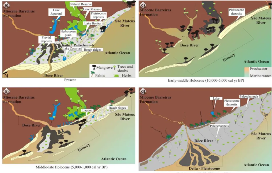
Figure 1 – A) South America with studies areas at the Brazilian littoral. B) Location of the study area and sampling site at the northern Brazil coast, northeastern Marajó Island, with sea water salinity, Amazon River plume and North Brazil Current-NBC (Santos et al., 2008). C) Sampling site at the Southeastern Brazil, State of Espirito Santo, Miocene Barreiras Formation and coastal plain of the Doce River, RGB Landsat composition – SRTM, with a topographical profile obtained from SRTM digital elevation data illustrating a large area slightly more depressed on coastal plain of the Doce River. D) Contact between arboreal vegetation and herbaceous vegetation at the coastal plain of the Doce River. E) Mangrove and herbaceous vegetation. F) Mangrove vegetation.
Figure 2 – Model of the Amazonian mangrove development during the Holocene in the: Macapá (2a and 2e); Marajó Island (2b and 2f) and eastern Marajó Island (2c and 2g).
Figure 3 – Model for coastal plain evolution of the Doce River during the late Pleitocene to Holocene.
2 CHAPTER II: THE LAST MANGROVES OF MARAJÓ ISLAND – EASTERN AMAZON: IIMPACT OF CLIMATE AND/OR RELATIVE SEA-LEVEL CHANGES
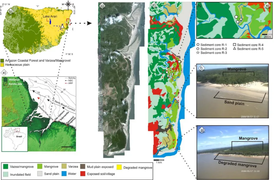
Figure 1 – Location of the study area: a) seawater salinity, Amazon River plume and North Brazil Current (Santos et al., 2008), b)Marajó Island; c) source coastal plain; d) vegetation units; e) sampling site on Soure coastal plain; f)mangrove and sand plain; g) degraded mangrove.
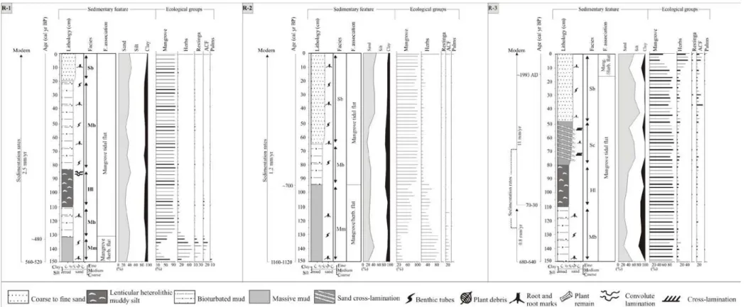
Figure 2 – Sediment profile with sedimentary features and ecological groups from cores R-1, R-2 and R-3.
Figure 3 – Sediment profile with sedimentary feature and ecological groups from cores R-4 and R-5.
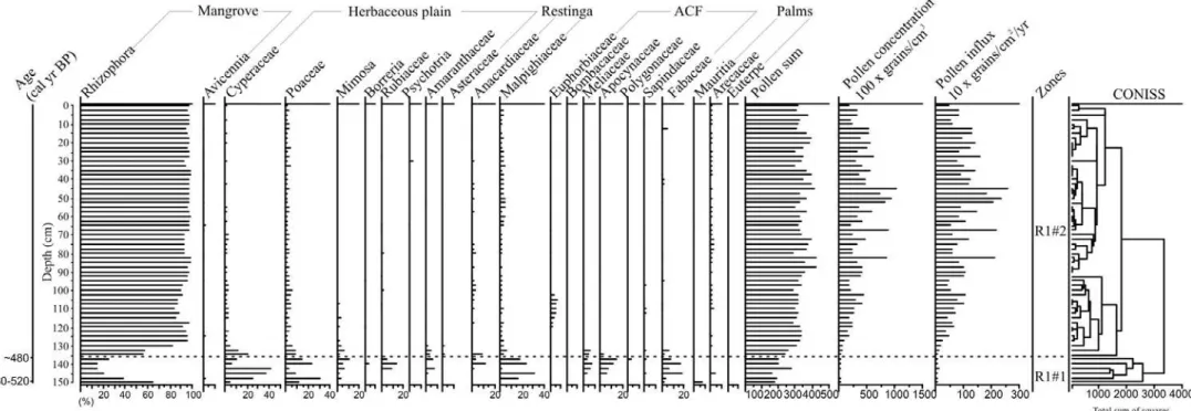
Figure 4 – Pollen record from core R-1 with percentages of the most frequent pollen taxa and sample age.
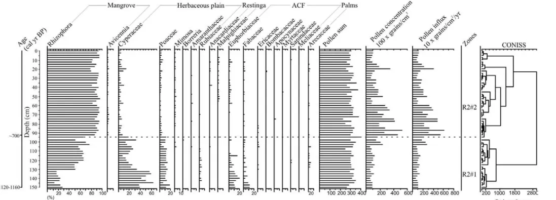
Figure 5 – Pollen record from core R-2 with percentages of the most frequent pollen taxa and sample age.
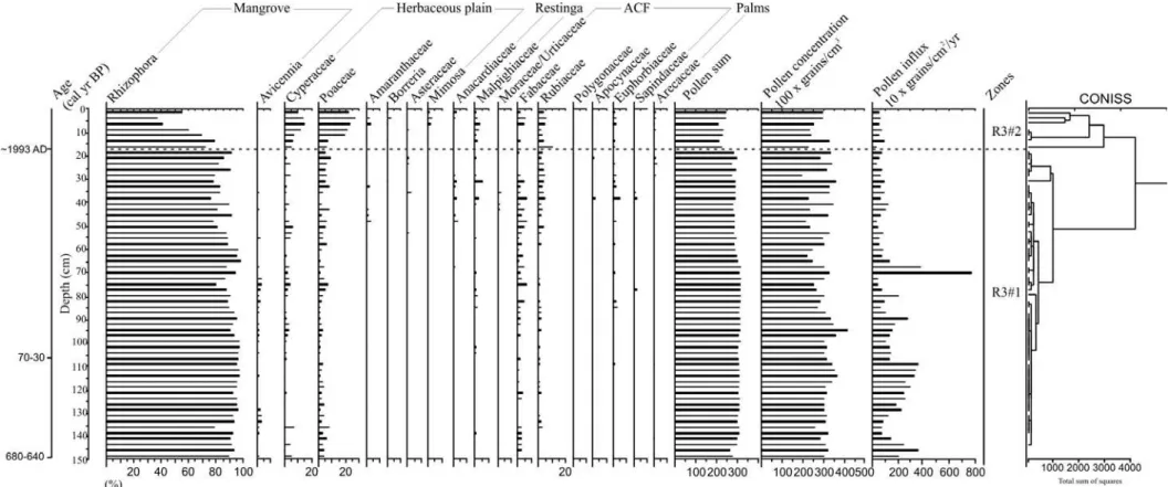
Figure 6 – Pollen record from core R-3 with percentages of the most frequent pollen taxa and sample age.
pollen taxa and sample age.
Figure 8 – Pollen record from core R-5 with percentages of the most frequent pollen taxa and sample age.
3 CHAPTER III: AN INTER-PROXY APPROACH TO ASSESSING THE DEVELOPMENT OF THE AMAZONIAN MANGROVE, DURING THE HOLOCENE
Figure 1 – Location of the study area: a) Sea water salinity, Amazon River plume and North Brazil Current (Santos et al., 2008); b) Marajó Island, which covers approximately 39,000 km2; c) Sampling in the mangrove; d) Sampling in the Lake São Luis; e) Mangrove and sand plain; f) Mangrove.
Figure 2 – Summary results for R-1 core: variation as a function of core depth from chronological, lithological profile, pollen analysis and geochemical variables.
Figure 3 – Summary results for R-2 core: variation as a function of core depth from chronological, lithological profile, pollen analysis and geochemical variables.
Figure 4 – Summary results for R-3 core: variation as a function of core depth from chronological, lithological profile, pollen analysis and geochemical variables.
Figure 5 – Summary results for R-4 core: variation as a function of core depth from chronological, lithological profile, pollen analysis and geochemical variables.
Figure 6 – Summary results for R-5 core: variation as a function of core depth from chronological, lithological profile, pollen analysis and geochemical variables.
Figure 7 – Binary diagram between δ13C x C/N for the different studies cores and different zones: a) R-1; b) R-2; c) R-3; d) R-4 and e) R-5 core. 7f) It represents the integration of δ13C and C/N data of organic matter preserved along the facies association Mangrove tidal flat. The different fields in the δ13C x C/N plots correspond to the member sources for organic matter preserved in sediments and trendline, on red line (modified from Meyers, 1997 and Lamb et al., 2006).
Figure 8 – Schematic representation of successive phases of sediment accumulation and vegetation change in the study area according to marine-freshwater influence gradient.
Figure 1 – a) Location of the study area, and its geological context. b) SRTM-DEM topography of the study site and lithostratigraphic profiles. C) Location of studied sediment cores and the spatial distribution of main geomorphological features.
Figure 2 – Topographic correlation among the facies associations identified in the studied cores.
Figure 3 – Stratigraphic description for Li01 with lithological profile, pollen analysis and geochemical variables.
Figure 4 – Stratigraphic description for Li24 with lithological profile, pollen analysis and geochemical variables.
Figure 5 – Diagram illustrating the relationship between δ13C and C/N for the different sedimentary facies, with interpretation according to data presented by Lamb et al. (2006) and Meyers (2003).
Figure 6 – Schematic representation of successive phases of sediment accumulation and vegetation change in the study area according to relative sea-level changes and sediment supply. ( cores location). Figure 7 – Global sea-level curves to the late Quaternary.
5 CHAPTER V: MANGROVE VEGETATION CHANGES ON HOLOCENE TERRACES OF THE DOCE RIVER, SOUTHEASTERN BRAZIL
Figure 1 – Location of the study area: a) Miocene Barreiras Formation and coastal plain of the Doce River; b) RGB Landsat composition – SRTM, with a topographical profile obtained from SRTM digital elevation data illustrating a large area slightly more depressed on coastal plain of the Doce River; c) palaeodrainage networks preserved, with lagoons and lake system originated at the Holocene. Note the presence of Pleistocene deposits. Observe also, the beach ridges which are related to coastal progradation.
Figure 2 – Sharp contact between arboreal vegetation and herbaceous vegetation marking the red line the contact zone between paleolake and the edge at the coastal plain of the Doce River. The herbs and grasses are current vegetation which has been developed during since at least 3043 cal yr BP above of paleolake sediments.
Figure 3 – The X-ray of the core with examples of sedimentary facies of the tidal plain deposits, illustrating: a) massive mud (facies Mm); b) parallel laminated mud (facies Mp), with rootlets and root marks; c) parallel-laminated sand (facies Sp); d) heterolithic mud/sand deposit with plain remain (facies Hm); e) lenticular heterolithic muddy silt with cross lamination (facies Hl); f) sandy layer, heterolithic mud/sand deposit with convolute lamination and shells (facies Hf).
organic geochemical variables and characteristics of organic matter influence. Pollen data are presented in pollen diagrams as percentages of the total pollen sum.
Figure 5 – Pollen diagram record with percentages of the most frequent pollen taxa, samples age, zones and cluster analysis.
Figure 6 – Diagram illustrating the relationship between δ13C and C/N ratio for the different sedimentary facies (foreshore, lagoon, lake and herbaceous plain), with interpretation according to data presented by Lamb et al. (2006); Meyers (2003) and Wilson et al. (2005) showing C4 plants with marine/brackish water influence and C3 plants with freshwater influence.
Figure 7 – Model of the geomorphology and vegetation development with successive phases of sediment accumulation according to relative sea-level changes during the Holocene.
LISTA DE TABELAS
1 CHAPTER I: VEGETATION AND MORPHOLOGY CHANGES IN MOUTH OF THE AMAZON-PA AND DOCE RIVER-ES DURING THE LATE QUATERNARY
Table 1 – Sites, vegetation types, sampling method, coordinate and location. Table 2 – Sediment cores with sampling site, depth, δ13C, 14C conventional and
calibrated ages (using Calib 6.0; Reimer et al., 2009) from Marajó Island (Amazon region) and coastal plain of the Doce River (Southeastern Brazil).
2 CHAPTER II: THE LAST MANGROVES OF MARAJÓ ISLAND – EASTERN AMAZON: IIMPACT OF CLIMATE AND/OR RELATIVE SEA-LEVEL CHANGES
Table 1 – Study site, vegetation types, sampling method and geographic coordinates in the coast-al plain of Soure–eastern Marajó Island.
Table 2 – Sediment samples selected for Radiocarbon dating and results (1, R-2, R-3, R-4 and R-5).
Table 3 – Lithofacies description of cores R-1, R-2, R-3, R-4 and R-5, from the Soure coastal plain, eastern margin Marajó Island.
3 CHAPTER III: AN INTER-PROXY APPROACH TO ASSESSING THE DEVELOPMENT OF THE AMAZONIAN MANGROVE, DURING THE HOLOCENE
Table 1 – List of the current vegetation and their δ13C value.
Table 2 – Material, Depth, δ13C, 14C conventional and calibrated ages (using Calib 6.0; Reimer et al., 2009).
Table 3 – Summary of facies association, pollen, isotopes and C/N values, with the proposed interpretation of the depositional environments.
4 CHAPTER IV: LANDSCAPE EVOLUTION DURING THE LATE QUATERNARY AT THE DOCE RIVER MOUTH, STATE OF ESPÍRITO SANTO, SOUTHEASTERN BRAZIL
Table 1 – Radiocarbon dates of studied sediment cores.
5 CHAPTER V: MANGROVE VEGETATION CHANGES ON HOLOCENE TERRACES OF THE DOCE RIVER, SOUTHEASTERN BRAZIL
Table 1 – Sediment samples selected for Radiocarbon dating and results from LI-32 core (coastal plain of the Doce River) with material, depth, δ13C, 14C conventional and calibrated ages (using Calib 6.0; Reimer et al., 2009). Table 2 – Summary of facies association with sedimentary characteristics, pollen
SUMÁRIO
DEDICATÓRIA AGRADECIMENTOS RESUMO
ABSTRACT
LISTA DE ILUSTRAÇÕES LISTA DE TABELAS
1 CHAPTER I: VEGETATION AND MORPHOLOGY CHANGES IN MOUTH OF THE AMAZON-PA AND DOCE RIVER-ES DURING THE LATE QUATERNARY
Introduction Study area
Geological Setting
Marajó island – northern brazil
Coastal plain of the doce river – southeastern brazil
Climate Vegetation
Materials and methods
Fields work and sample processing
Palynological analysis
δ13
C, δ15N and C/N
Radiocarbon dating
Results and discussions
Marajó Island – Northern Brazil
Geomorphology changes in the coastal plain of the Doce River during the
late Pleistocene and Holocene
Mangrove vegetation changes during the Holocene
Conclusions
2 CHAPTER II: THE LAST MANGROVES OF MARAJÓ ISLAND – EASTERN AMAZON: IMPACT OF CLIMATE AND/OR RELATIVE SEA-LEVEL CHANGES
* Paper published on Review of Palaeobotany and Palynology 187 (2012) 50-65 http://www.sciencedirect.com/science/article/pii/S0034666712002205
Introduction Study area
Present climate and vegetation
Materials and methods
Field work and sample processing
Pollen and spore analyses
Radiocarbon dating
Results
Radiocarbon dates and sedimentation rates
Facies description and pollen association
Mangrove/herbaceous flat facies association
Mangrove flat facies association
Lagoon facies association
Foreshore facies association
Lake facies association
Discussion
Pollen signal and vegetation changes in Marajó Island during the
Holocene (central and eastern coastal zone)
Mangrove dynamics during the last decades in the eastern coastal zone of
Marajó Island
Conclusions
3 CHAPTER III: AN INTER-PROXY APPROACH TO ASSESSING THE DEVELOPMENT OF THE AMAZONIAN MANGROVE, DURING THE HOLOCENE
* Paper accepted on Vegetation History and Archaeobotany Abstract
Introduction Study site
Geological and geomorphological setting
Regional climate and oceanographic characteristics
Modern vegetation
Facies analysis
Pollen analysis
Organic geochemistry
Radiocarbon dating
Results
Radiocarbon dates and sedimentation rates
δ13
C values of modern vegetation
Facies, pollen description and isotope values of the sediment cores
R-1 core (mangrove/várzea, 150 cm)
R-2 core (mangrove, 150 cm)
R-3 core (herbaceous plain/mangrove, 150 cm)
R-4 core (mangrove, 225 cm)
R-5 core (lake/herbaceous plain, 256 cm)
Interpretation and discussion
First phase (Early- to mid-Holocene – mangrove): ~7500 to ~3200 cal yr
BP
Second phase (Mid- to late-Holocene. – lake): ~3200 to ~1880 cal yr BP
Third phase (Late Holocene to modern – mangrove): ~1700 cal yr BP to
modern
Amazon River and Relative Sea Level (RSL) controlling mangrove
dynamics
Conclusions
4 CHAPTER IV: LANDSCAPE EVOLUTION DURING THE LATE QUATERNARY AT THE DOCE RIVER MOUTH, ESPÍRITO SANTO STATE, SOUTHEASTERN BRAZIL
* Paper accepted on Palaeogeography, Palaeoclimatology, Palaeoecology Abstract
Introduction Study area Location
Geology and geomorphology
Climate
Methods Remote sensing
Sampling processing and facies description
Pollen and spore analysis
Isotopic and chemical analysis
Radiocarbon dating
Results
Radiocarbon dates and sedimentation rates
Facies description
Delta plain and Estuary central basin/lagoon-bay (A)
Facies Association A1- Beach ridge complex
Facies Association A2- Lake
Facies Association A3-Fluvial channel
Facies Association A4-Tidal channel
Facies Association A5- Marshes
Facies Association A6- Estuary central basin/lagoon-bay
Deltaic system (B)
Facies Association B1-Delta Plain
Facies Association B2-Delta Front
Facies Association B3-Prodelta
Palaeoenvironmental Interpretation
Climate and sea-level changes during the late Quaternary Sea-level changes and fluvial sediment supply
Conclusion
5 CHAPTER V: MANGROVE VEGETATION CHANGES ON HOLOCENE TERRACES OF THE DOCE RIVER, SOUTHEASTERN BRAZIL
* Paper published on Catena 110 (2013) 59-69
http://www.sciencedirect.com/science/article/pii/S0341816213001501 Abstract
Introduction Modern settings
Study area and geological setting
Climate
Materials and methods
Field work and sampling processing
Facies description
Palynological analysis
Isotopic and chemical analysis
Radiocarbon dating
Results
Radiocarbon date and sedimentation rates
Facies, pollen description and isotopes values from sediment core
Facies association A (foreshore)
Facies association B (lagoon)
Facies association C (lake)
Facies association D (herbaceous plain)
Interpretation and discussion Early Holocene: foreshore to lagoon
Middle-Late Holocene: Lagoon/lake transition to herbaceous flat
Holocene sea-level changes, climate and vegetation dynamics
Conclusion
CHAPTER I:
VEGETATION AND MORPHOLOGY CHANGES IN MOUTH
OF THE AMAZON-PA AND DOCE-ES RIVER DURING THE
Introduction
Climate change and Atlantic sea-level oscillation have produced an impact on sedimentary dynamics and displacements of coastal ecosystems along the Brazilian littoral during the late Quaternary (Suguio et al., 1985; Dominguez et al., 1992; Ledru et al., 1996; Angulo and Lessa, 1997; Behling et al., 1998; Grimm et al., 2001; Bezerra et al., 2003; Martin et al., 2003; Cohen et al., 2005a,b; Angulo et al., 2006; Vedel et al., 2006; Behling et al., 2007; Sawakuchi et al., 2008; Lara and Cohen, 2009; Zular et al., 2013, Guimarães et al., 2012, 2013; Buso Junior et al., 2013 – in press; França et al., 2012; 2013a,b – in press). The
region is largely controlled by complex interactions involving gradients of tidal oscillation, river discharge, littoral currents, sediment and nutrient supply and winds (Dominguez, 2006; Schaeffer-Novelli et al., 2000; Cohen et al., 2005a,b; Amaral et al., 2006; Cohen et al., 2009; Dillenburg et al., 2009; Sanders et al., 2010, 2012; Pessenda et al., 2012; Smith et al., 2012; Guimarães et al., 2012).
Regarding the mangroves, they occur broadly on the Brazilian coast (Schaeffer-Novelli et al., 2000), and they have reacted clearly to climate change and sea-level fluctuations, as they respond to environmental factors such as water salinity, nutrients and input of sediment and freshwater (Krauss et al., 2008; Stevens et al., 2006; Stuart et al., 2007). The evolutionary development of these forests is controlled by land-ocean interaction, and their expansion is determined by topography, sediment geochemistry (Alongi, 2002), as well as current energy conditions (Woodroffe, 1982). This ecosystem is highly adaptive, with plants tolerant of extreme environmental conditions such as high salinity, anoxia and constant water inundation (Vannucci, 2001). This adaptability has allowed mangroves to withstand environmental change throughout the Holocene (Monacci et al., 2009), and become a marker of great importance for scientific analysis of coastal change (Blasco et al., 1996).
The mangroves in the northern Brazilian littoral were present along the current coastline since the early Holocene (Behling, 2001; Cohen et al., 2005a,b; 2012; Smith et al., 2011; França et al., 2012). This ecosystem expanded along the coastal plain of the Doce River during the early-middle Holocene (Buso Junior et al., 2013 – in press; França et al., 2013a – in press). Currently the mangroves have presented a limited distribution in the northern
Brazilian littoral influenced by Amazon River and along the southeastern Brazilian coastline (Amaral et al., 2006; Cohen et al., 2012; Pessenda et al., 2012).
al., 2008; Cohen et al., 2009; Smith et al., 2011; França et al., 2012; Guimarães et al., 2012; França et al., 2013b – in press). In this context, the goal of this study was to compare the
impact of sea-level fluctuations, and sediment/freshwater supply changes in mangrove areas and morphological dynamics influenced by Amazon and Doce River during the late Quaternary. This was carried out by the integration of multi-proxy data, including pollen, sedimentary features, δ13C, δ15N, C/N and radiocarbon-date from twelve cores sampled along the northern (Chapters II and III) and southeastern Brazilian coast (Chapters IV and V).
Study area
The study sites are located on Marajó Island (northern Brazil), at the mouth of the Amazon River, and in the coastal plain of the Doce River (southeastern Brazil) (Figure 1). Currently, the Marajó Island’s coastal vegetation is dominated by a regime of semidiurnal meso- and macro-tides (tidal range of 2 to 4 m and 4 to 6 m, respectively) with variations during the spring tide between 3.6 and 4.7 m (DHN, 2003), and influenced by Amazon River discharge of approx. 170,000 m3 s-1 (ANA, 2003). Consequently, the river discharge and hydrodynamic conditions allow a strong reduction of tidal water salinity along the adjacent coast (Vinzon et al., 2008; Rosario et al., 2009) with salinity values between 7 and 30‰.
Geological Setting
Marajó Island – Northern Brazil
The coastal plain of Soure is located on the Pará platform of northern Brazil. It pertains to a large area of crystalline and Palaeozoic sedimentary basement that remained tectonically stable relative to adjacent Cretaceous and Cenozoic sedimentary basins (Rossetti et al., 2008). The coastal plateau of northern Brazil is formed by the Barreiras Formation. These deposits occur from northern to southeastern Brazil and are of Miocene age (Arai, 1997).
Except for a narrow belt where the Barreiras Formation occurs, the eastern portion of the island is characterized by lowlands with altitudes averaging 4-6 m above the modern sea-level (Rossetti et al., 2007, 2008) and is dominated by Holocene sedimentation, which is topographically slightly lower than the western side (Behling et al., 2004; Rossetti et al., 2007; Lara and Cohen, 2009). Along the eastern portion, the Barreiras Formation is represented by sandstones and mudstones followed by post-Barreiras deposits (Rossetti et al., 2008).
Marajó Island has a river system consisting of numerous small, straight and meandering channels and ponds that are either permanent or ephemeral (Bemerguy, 1981). The flat surface of the eastern part of the island has been deeply incised by a drainage system during the Pleistocene and Holocene.
Coastal plain of the Doce River – Southeastern Brazil
The study site is located in the coastal plain between two large rivers, Doce and São Mateus, northern Espírito Santo – Brazil, running along a nearly N-S section between Conceição da Barra and Barra do Riacho (Suguio et al., 1982; Bittencourt et al., 2007). The Holocene sedimentary history in this sector is strongly controlled by RSL changes, fluvial supply and longshore transport. The formation of a barrier island/lagoonal system began about 7000 yr BP (Suguio et al., 1982; Martin et al., 1996; Martin et al., 2003).
constituted by sandstones, conglomerates and mudstones attributed mainly to Neogene fluvial and alluvial fan deposits, but possibly including deposits originating from a coastal overlap associated with Neogene marine transgressions (Arai, 2006; Dominguez et al., 2009). The drainage catchment slopes gently down towards the sea; and (3) a coastal plain area, with fluvial, transitional and shallow marine sediments, which were deposited during RSL changes (Martin et al., 1987) and (4) an inner continental shelf area (Asmus et al. 1971).
Climate
Climate along the northern coast of Brazil is tropical (warm and humid), with annual precipitation averaging 2300 mm (Lima et al., 2005). The rainy season occurs between the months of December and May, with a drier period between June and November. Average temperatures range between 25º and 29º C (Marengo et al., 1993, 2001; Nobre and Shukla, 1996; Fu et al., 2001; Liebmann and Marengo, 2001). Southeastern Brazil is characterized by a warm and humid tropical climate with annual precipitation averaging 1400 mm (Peixoto and Gentry, 1990). Precipitation generally occurs in the summer with a dry fall-winter season. The rainy season occurs between the months of November and January with a drier period between May and September. The average temperature ranges between 20º and 26º C (Carvalho et al., 2004).
Vegetation
Modern vegetation on Marajó Island consists of herbaceous flats, natural open areas that are dominated by Cyperaceae and Poaceae, “várzea” vegetation (swampland seasonally and permanently inundated by freshwater) is composed of wetlands trees such as Euterpe oleraceae and Hevea guianensis, while the “terra firme” vegetation, represented by the
Amazon Coastal Forest (ACF) unit, is characterized by Cedrela odorata, Hymenaea courbaril
and Manilkara huberi (Behling et at., 2004; Cohen et al., 2008; Smith et al., 2011, 2012).
“Restinga” (shrub and herb vegetation that occurs on sand plains and on dunes close to the shore line) is dominated by Anacardiaceae and Malpighiaceae. Mangroves (tree heights reaching ~20 m) are classified as Rhizophora sp. dominated with a presence of Avicennia sp.
and Laguncularia sp. (Cohen et al., 2008).
this region, where the most representative plant families are Annonaceae, Fabaceae, Myrtaceae, Sapotaceae, Bignoniaceae, Lauraceae, Hippocrateaceae, Euphorbiaceae, and Apocynaceae (Peixoto and Gentry, 1990). The mangrove ecosystem is characterized by
Rhizophora sp., Laguncularia sp. and Avicennia sp., which are currently restricted to the
northern and southern littoral part of the coastal plain (Bernini et al., 2006).
Materials and methods
Fields work and sample processing
For this study twelve sediment cores were analysed from areas occupied by different vegetation units (Table 1): “várzea” (R-1), mangroves (R-2 and R-4), mangrove and herbaceous vegetation (R-3), lacustrine herbaceous plain (R-5), herbaceous plain (01, LI-23, LI-26, LI-31, LI-32 and LI-33) and mixture between forest and herbaceous plain (LI-24). Three sediment cores were collected in northern Brazil (R-1, R-2 and R-3) using a Russian sampler (Cohen, 2003) and two sediment cores were taken with a vibracorer using an aluminium tube (R-4 and R-5). Considering the coastal plain of the Doce River, one sediment core was sampled (LI-32) using a Russian sampler and to the others was used a percussion drilling Robotic Key System (RKS), model COBRA MK1 (COBRA Directional Drilling Ltd., Darlington, U.K.).
Table 1 – Sites, vegetation types, sampling method, coordinate and location. Code
site
Unit vegetation Sampling method
Coordinates Location
R-1 Mangrove/várzea RSC S00º40’26”/W48º29’37” Marajó Island
R-2 Mangrove RSC S00º40’23”/W48º29’38” Marajó Island
R-3 Mangrove/herbaceous RSC S00º40’25”/W48º29’35” Marajó Island R-4 Mangrove VBC S00º39’37”/W48º29’3.3” Marajó Island R-5 Herbaceous plain VBC S00º55’41”/W48º39’47” Marajó Island LI-01 Herbaceous plain RKS S19º10’53”/W39º51’55” Doce River LI-23 Herbaceous plain RKS S19º08’58”/W39º53’29” Doce River LI-24 Forest/herbaceous plain RKS S19º9’8.5”/W39º55’47” Doce River LI-26 Herbaceous plain RKS S19º07’4”/W39º52’57” Doce River LI-31 Herbaceous plain RKS S19º11’16”/W39º49’33” Doce River LI-32 Herbaceous plain RSC S19º11’36”/W39º48’2” Doce River LI-33 Herbaceous plain RKS S19º10’19”/W39º53’10” Doce River RSC. Russian Sampler; VBC. Vibracorer; RKS. Percussion drilling
Palynological analysis
The sediment cores were sub-sampled with 372 total samples at different downcore intervals. 1 cm3 of sediment was taken for palynological analysis. All samples were prepared using standard analytical techniques for pollen including acetolysis (Faegri and Iversen, 1989). Sample residues were placed in Eppendorf microtubes and kept in a glycerol gelatin medium. Reference morphological descriptions (Roubik and Moreno, 1991; Behling, 1993; Herrera and Urrego, 1996; Colinvaux et al., 1999) were consulted for identification of pollen grains and spores. A minimum of 300 pollen grains were counted in each sample. Software packages TILIA and TILIAGRAPH were used to calculate and plot pollen diagrams (Grimm, 1990). The pollen diagrams were statistically subdivided into zones of pollen and spore assemblages using a square-root transformation of the percentage data, followed by stratigraphically constrained cluster analysis (Grimm, 1987).
δ13
C, δ15N and C/N
per mil notation with an analytical precision greater than 0.2‰, with respect to the VPDB standard and atmospheric air, respectively.
The relationship between δ13C, δ15N and C/N was used to provide information about the origin of organic matter preserved in the coastal environment (Fry et al., 1977; Peterson and Howarth, 1987; Schidlowski et al., 1983; Meyers, 1997, 2003; Wilson et al., 2005; Lamb et al., 2006).
The δ13C values have different mean value between terrestrial plants, freshwater and marine sources (Meyers, 1997). Some classes of plants also have different sources of CO2 (air vs. water) or different carbon isotopic fractionations (C3 vs. C4 photosynthetic pathways). Atmospheric nitrogen has a δ15N value of zero, and terrestrial plants tends to have δ15N values close to 0‰, whereas Spartinasp. has δ15N values around +6‰, and near shore plankton have
values of around +6 to +10‰ (Wada 1980; Macko et al., 1984; Altabet and McCarthy, 1985).
Radiocarbon dating
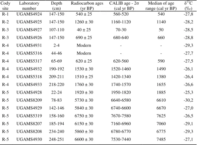
Table 2 – Sediment cores with sampling site, depth, δ13C, 14C conventional and calibrated ages (using Calib 6.0; Reimer et al., 2009) from Marajó Island (Amazon region) and coastal plain of the Doce River (Southeastern Brazil).
Cody site and lab.
number Sampling site Depth (m)
14C ages
(yr B.P.) CALIB - (cal yr B.P.) 2σ Median (cal yr B.P.) δ
13C
(‰) R-1
UGAMS4924 Marajó 1.47-1.50 540 ± 25 560-520 540 -27.8
R-2
UGAMS4925 Marajó 1.47-1.50 1260 ± 30 1160-1120 1150 -28.2
R-3
UGAMS4927 Marajó 1.07-1.10 40 ± 25 70-30 50 -28.5
UGAMS4926 Marajó 1.47-1.50 690 ± 25 680-640 660 -28.8
R-4
UGAMS5318 Marajó 2.09-2.11 1510 ± 25 1420-1340 1380 -26.4
UGAMS4933 Marajó 2.18-2.20 1760 ± 30 1740-1570 1655 -26.6
R-5
UGAMS4928 Marajó 0.22-0.24 1920 ± 30 1950-1820 1880 -25.3
UGAMS8209 Marajó 0.78-0.83 5730 ± 30 6640-6580 6610 -30.2
UGAMS4929 Marajó 1.42-1.46 5840 ± 30 6740-6600 6670 -27.0
UGAMS8207 Marajó 1.85-1.94 6150 ± 30 7160-6960 7060 -29.1
UGAMS4930 Marajó 2.48-2.51 6600 ± 30 7530-7440 7500 -27.1
LI-01
UGAMS10565 D. River 1.65-1.75 6710 ± 30 7556-7622 7600 -
UGAMS10566 D. River 3.70-3.75 24,610 ± 70 29,226-29,678 29,500 - LACUFF13018 D. River 6.20-6.30 33,358 ± 948 36,105-40,014 38,000 - UGAMS11693 D. River 8.80-8.86 31,220 ± 100 35,162-36,321 35,700 - LACUFF00038 D. River 11.5-11.7 44,232 ± 812 45,775-49,391 47,500 - LI-24
UGAMS10567 D. River 0.80-0.90 Modern Modern Modern -
UGAMS10568 D. River 2.70-2.80 1480 ± 25 1310-1400 1355 -32.5
UGAMS10569 D. River 4.80-4.90 4500 ± 25 5210-5290 5250 -29.8
UGAMS10570 D. River 6.73-6.77 6330 ± 30 7170-7230 7200 -29.6
UGAMS10571 D. River 9.40-9.50 6560 ± 30 7545-7555 7550 -29.6
LI-31
UGAMS10572 D. River 1.05-1.10 4320 ± 25 4840-4893 4860 -
UGAMS10573 D. River 4.95-5.00 3600 ± 20 3845-3933 3890 -
UGAMS10574 D. River 6.55-6.65 25,970 ± 80 30,465-31,022 30,700 - LI-32
LACUFF13019 D. River 0.67-0.72 2877 ± 79 3246-2840 3043 -
LACUFF12039 D. River 1.40-1.45 6237 ± 66 7278-6955 7116 -
UGAMS11695 D. River 3.40-3.45 6330 ± 30 7318-7172 7245 -27.6
UGAMS11694 D. River 4.30-4.35 6380 ± 30 7339-7259 7300 -27.5
Results and discussions
Marajó Island – Northern Brazil
The cores from Marajó Island consist of dark gray and light brown muddy and sandy silt sediments. Grain size increases towards the top of the core (see Chapter II). The δ13C isotopic results exhibit values from –29.34‰ to –22.07‰ (mean= –26.55‰), which indicate the dominance of C3 plants (–32‰ to –21‰; Deines, 1980; Boutton, 1996). The δ15N record shows values between –0.61‰ and +6.04‰ (mean= +2.46‰), which suggests a mixture of terrestrial plants (~0‰) and aquatic matter (+6 to +10‰) as observed by Wada (1980), Macko et al. (1984) and Altabet and McCarthy (1985). The C/N values showed considerable variation between 3.55 and 45.67 (mean= 22.04), which also indicate a mixture of organic matter from vascular plants and algae (<10 algae dominance and >12 vascular plants; Meyers, 1994; Tyson, 1995) (França et al., 2013b – in press; see Chapter III).
The texture analysis and description of sedimentary structures of the materials collected in the tidal flat, together with pollen records, grain size, isotopic (δ13C and δ15N) and C/N values, allowed five facies associations to be defined: mangrove flat, lake, foreshore, lagoon and mangrove/mixed flat on the eastern coast of the island during at least the last 7500 cal yr BP.
The results indicate a tidal mud flat colonized by mangroves with estuarine organic matter between ~7500 and ~3200 cal yr BP. During the late Holocene this led to a gradual migration of mangroves from the central region to the northeastern littoral zone of the island, and, consequently, its isolation since at least ~1150 cal yr BP. This likely results from lower tidal water salinity caused by a relatively wet period that resulted in greater river discharge during the late Holocene. The northeastern area of the island exhibits relatively greater tidal water salinity, due to the southeast-northwest trending littoral current which brings brackish waters from more marine influenced areas. It has provided a refuge for the mangroves of Marajó Island (França et al., 2012, see chapter II).
Over the last century, the increase in flow energy evidenced by upward mud/sand transitions also contributes to mangrove retraction, as recorded in the upper part of core R-3 (see Chapter II). This is mainly due to landward sand migration, which covers the mudflat and asphyxiates the mangrove. The increase in flow energy and exposure to tidal influence may
The mangrove dynamic during the Holocene has also been recorded by Cohen et al. (2005a,b, 2009; 2012), Guimarães et al. (2012), Smith et al. (2012) and França et al. (in press) at the northern Brazilian coast, related to RSL change and or/ river water discharge (Figure 2).
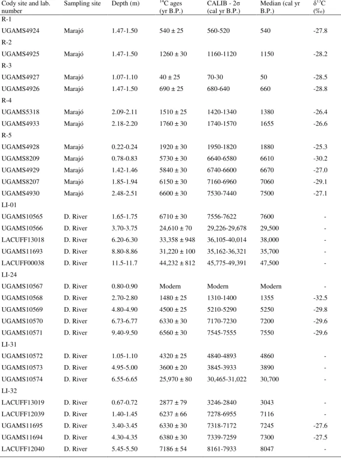
Geomorphology changes in the coastal plain of the Doce River during the late Pleistocene
and Holocene
The observed succession of facies association Delta Plain, Estuary Central Basin/Lagoon-bay (mangrove/herbaceous flat) and Deltaic System might be a product of driving forces regulated by cyclic mechanism leading to a delta, estuary and following to a delta plain environment. The Holocene evolution had been controlled by relative sea-level changes, fluvial sediment transport and longshore transport. The build up of its Holocene part began with the formation of a estuary/lagoonal system (Figure 3 and chapter IV).
Probably, the changes in this depositional environment were driven by the equilibrium between the sea-level changes and fluvial sediment supply during the late Pleistocene and Holocene. Probably, this depositional architecture of the late Pleistocene coastal system evolving from a prodelta to a delta front, followed by the delta plain in response to relative sea-level fall between ~47,500 and ~29,400 cal yr B.P.
The deltaic system deposits were recorded during the eustatic sea-level fall between ~47,500 and ~29,400 cal yr B.P. The sediment accumulated during the LGM and the late Pleistocene/Holocene transition was not characterized. Probably, from ~ 30,000 cal yr B.P. to ~7500 cal yr B.P., a sedimentary hiatus occurred, related to an erosive event associated to the rapid post glacial sea-level rise.
The estuary with mangroves was formed during the sea-level rise of the Holocene (~7550 to ~5250 cal yr BP). These environments were formed during the early and middle Holocene as a response of an eustatic sea-level rise that resulted in significant changes in the coastal geomorphology. During the early Holocene, the arboreal and herbaceous vegetation dominated the coastal plain, and the equilibrium between the relative sea-level and fluvial sediment supply created conditions to the development of an estuarine system with fluvial and tidal channels, lagoons and tidal flats colonized by mangroves.
32
33
Mangrove vegetation changes during the Holocene
During the Holocene, the post-glacial sea-level rise and changes in river water discharge have been considered the main driving forces behind the expansion/contraction of mangroves in northern Brazil (Cohen et al., 2008; Lara and Cohen, 2009; França et al., 2012; Guimarães et al., 2012; Smith et al., 2012). The data from Marajó Island indicates a tidal mud flat colonized by mangroves with an influence of estuarine organic matter and terrigenous input between at least ~7500 and ~3200 cal yr BP (chapters II and III). This is likely due to the relatively higher marine influence caused by post-glacial sea-level rise, and the dry period experienced by the Amazon region during the early and middle Holocene (Pessenda et al., 2001; Behling and Hooghiemstra, 2000; Freitas et al., 2001; Sifeddine et al. 2001; Weng et al., 2002; Bush et al., 2007). As rainfall controls the volume of the Amazon River (Eisma et al., 1991; Maslin and Burns, 2000; Latrubesse and Fanzinelli, 2002), lower precipitation resulted in severely reduced freshwater discharge (Amarasekera et al., 1997; Toledo and Bush, 2007, 2008). This led to a greater influence of saline marine water and mangrove expansion in the northern Brazil (Cohen et al., 2012).
During the late Holocene occurred a decrease in mangrove vegetation area in the Marajó Island. Likely it was caused by an increase in river discharge, which resulted in a relatively low tidal water salinity during that time (França et al., 2012; see chapter II and III).
In contrast, the dynamics of these forests in southeastern Brazil have been controlled mainly by sediment supply associated to sea-level fluctuations. The post-glacial sea-level rise caused change in the coastal environment along southeastern Brazil (Giannini et al., 2007; Guedes et al., 2011; Pessenda et al., 2012), which resulted in the formation of numerous lagoons and estuarine systems around 7800 cal yr BP (Martin et al., 1996; Sallun et al., 2012) colonized by mangrove and herbaceous vegetation (Buso Junior et al., in press). Sea-level
Doce River indicate a predominance of muddy sediments supply and that C4 plants are present, with greater influence from C3 plants and estuarine water. During the middle to late Holocene, an increase in the contribution of sandy sediments and terrestrial organic matter occurred with C4 plants influence (chapters IV and V), probably associated with a RSL fall, resulting in a retraction of mangroves and expansion of herbaceous vegetation, trees and shrubs.
During the late Holocene, there was a decrease in the extent of mangrove vegetation in Marajó Island and in the coastal plain of the Doce River, mainly caused by increase of freshwater discharge and sandy sediment supply associated to RSL fall, respectively. Mangrove environments are now isolated in areas with some marine influence and suitable mud sediment supply. Regarding the coastal plain of the Doce River, the data indicate that the input of freshwater organic matter and terrigenous material during the late Holocene was higher than the early and middle Holocene. This transition from marine to freshwater influence, likely is due to the combined action of RSL fall and sedimentary supply during the late Holocene. Furthermore, tectonic activities may have caused RSL changes in both studied sectors with a potential impact on mangrove distribution (Rossetti et al., 2007; Miranda et al., 2009; Rossetti et al., 2012).
Conclusions
The delta plain of the Doce River presents a stratigraphic sequence with development of a deltaic system to estuarine and to continental terraces produced by the interplay of relative sea-level changes and sediment river discharge. The regressive deposits reveal highstand systems tracts and forced/normal regressive systems tracts in cycles developed according to the rate of relative sea-level changes combined with local sediment supply.
Therefore, the equilibrium between the relative sea-level and fluvial sediment supply allowed the development of a deltaic system in response mainly to sea-level fall during at least ~47,500 and ~29,400 cal yr B.P (chapter IV). After the post-glacial sea-level rise, an estuarine complex was developed with wide tidal mud flats occupied by mangroves during the early and middle Holocene both in the mouth of the Amazon (chapter II and III) and Doce River (chapter V).
Holocene, there was a decrease in the extent of mangrove vegetation in Marajó Island and in the coastal plain of the Doce River, mainly caused by increase of freshwater discharge and sandy sediment supply associated to RSL fall, respectively. Mangrove environments are now isolated in areas with some marine influence and suitable mud sediment supply. Regarding the southeastern Brazil, the data indicate that the input of freshwater organic matter and terrigenous material during the late Holocene was higher than the early and middle Holocene. This transition from marine to freshwater influence, likely is due to the combined action of RSL fall and sedimentary supply during the late Holocene. In the Marajó Island, during the late Holocene, there was a return to more continental conditions, heavily influenced by freshwater with mangroves isolated to a small area (100-700 m width) in the northeastern part of the island (chapter III).
Over the last century, the increase in flow energy evidenced by upward mud/sand transitions also contributes to mangrove retraction in the Marajó Island (see chapter II). This is mainly due to landward sand migration, which covers the mudflat and asphyxiates the mangrove. The increase in flow energy and exposure to tidal influence may have been driven
CHAPTER II:
THE LAST MANGROVES OF MARAJÓ ISLAND – EASTERN
AMAZON: IMPACT OF CLIMATE AND/OR RELATIVE
SEA-LEVEL CHANGES
Abstract
The dynamics, over the last 7,500 years, of a mangrove at Marajó Island in northern Brazil were studied by pollen and sedimentary facies analyses using sediment cores. This island, located at the mouth of the Amazon River, is influenced by riverine inflow combined with tidal fluctuations of the equatorial Atlantic Ocean. Herbaceous vegetation intermingled with rainforest dominates the central area of the island, while várzea is the main vegetation
type along the littoral. In particular, the modern northeastern coastal zone is covered by a mosaic of dense rainforest, herbaceous vegetation, mangroves, várzea , and restinga. The
integration of pollen data and facies descriptions indicates a tidal mud flat colonized by mangroves in the interior of Marajó Island between ~ 7,500 cal yr BP and ~ 3,200 cal yr BP. During the late Holocene, mangroves retracted to a small area (100-700 m in width) along the northeastern coastal plain. Mangrove expansion during the early and mid Holocene was likely caused by the post-glacial sea-level rise which, combined with tectonic subsidence, led to a rise in tidal water salinity. Salinity must have further increased due to low river discharge resulting from increased aridity during the early and mid Holocene. The shrinking of the area covered by mangrove vegetation during the late Holocene was likely caused by the increase in river discharge during the late Holocene, which has maintained relatively low tidal water salinity in Marajó Island. Tidal water salinity is relatively higher in the northeastern part of the island than in others, due to the southeast-northwest trending current along the littoral. The mixing of marine and riverine freshwater inflows has provided a refuge for mangroves in this area. The increase in flow energy during the last century is related to landward sand migration, which explains the current retraction of mangroves. These changes may indicate an increased exposure to tidal influence driven by the relative sea-level rise, either associated with global fluctuations or tectonic subsidence, and/or by an increase in river water discharge.
Introduction
Mangroves are highly susceptible to climatic changes and sea-level oscillations (e.g., Fromard et al., 2004; Versteegh et al., 2004; Alongi, 2008; Berger et al., 2008). They have been almost continuously exposed to disturbance as a result of fluctuations in sea-level over the last 11,000 years (Gornitz, 1991; Blasco et al., 1996; Sun and Li, 1999; Behling et al., 2001; Lamb et al., 2006; Alongi, 2008; Berger et al., 2008; Cohen et al., 2008; Gilman et al., 2008). During the Holocene, the post-glacial sea-level rise and changes in river water discharge have been considered the main driving forces behind the expansion/contraction of mangroves in northern Brazil (Cohen et al., 2008; Lara and Cohen, 2009; Guimarães et al., 2010; Smith et al., 2012). However, important changes in coastal morphology have been recorded in this region as a result of tectonic reactivations, which could have modified the relative sea-level (RSL), with a potential impact on mangrove distribution (Rossetti et al., 2007; Miranda et al., 2009; Rossetti et al., 2012).
An empirical model based on an ecohydrological approach, which allows the integration of hydrographical, topographical and physicochemical information with vegetation characteristics of mangroves and marshes, indicates that changes in pore water salinity affect vegetation boundaries (Cohen and Lara, 2003; Lara and Cohen, 2006). In addition to studies in northern Brazil, the relationship between mangrove distribution and sediment geochemistry has been widely studied in other coastal regions (Hesse, 1961; Baltzer, 1970; Walsh, 1974; Baltzer, 1975; Snedaker, 1982; Lacerda et al., 1995; McKee, 1995; Pezeshki et al., 1997; Clark et al., 1998; Youssef and Saenger, 1999; Matthijs et al., 1999; Alongi et al., 1998, 1999, 2000).
Generally, mangroves are distributed parallel to the coast with some species dominating areas more exposed to the sea, and others occurring landward at higher elevations (Snedaker, 1982). This zonation is a response of mangrove species mainly to tidal inundation frequency, nutrient availability, and porewater salinity in the intertidal zone (Hutchings and Saenger, 1987).
Mangroves of the littoral of northern Brazil follow well-known patterns (Behling et al., 2001; Cohen et al., 2005a), where salinity results in the exclusion of freshwater species (Snedaker, 1978) and leads to characteristic patterns of species zonation and predictable types of community structure (Menezes et al., 2003). Mangroves are more tolerant to soil salinity than is várzea forest (Gonçalves-Alvim et al., 2001) and sediment salinity is mostly controlled
Changes in mangrove distribution may also reflect changes in variables that control coastal geomorphology (e.g. Blasco et al., 1996; Fromard et al., 2004; Lara and Cohen, 2009). The development of mangroves is regulated by continent-ocean interactions and their expansion is determined by the topography relative to sea-level (Gornitz, 1991; Cohen and Lara, 2003) and flow energy (Chapman, 1976; Woodroffe, 1989), where mangroves preferentially occupy mud surfaces. Thus, a relative rise in sea-level may result in mangroves migrating inland due to changes in flow energy and tidal inundation frequency. Similarly, vegetation on elevated mudflats is subject to boundary adjustments, since mangroves can migrate to higher locations and invade these areas (Cohen and Lara, 2003).
The potential of each variable to influence mangrove establishment will depend on the environmental characteristics of the given littoral. Climate and hydrology are the main factors controlling the modern distribution of geobotanical units along the coast of the Amazon (Cohen et al., 2008, 2009). According to these authors, mangroves and saltmarshes dominate the marine-influenced littoral when tidal water salinity lies between 30 and 7‰ to the southeastern coastline, and várzea and herbaceous vegetation dominate
freshwater-influenced coasts with tidal water salinity below 7‰ in the northwest. The littoral of Marajó Island, at the mouth of the Amazon River, is part of the fluvial sector (Figure 1a) (Cohen et al., 2008; Smith et al., 2011, 2012).
The mangroves of Marajó Island are currently restricted to a relatively narrow section of the northeastern area of the island (Cohen et al., 2008; Smith et al., 2012). This mangrove has developed continuously since at least 2,700 cal yr BP (Behling et al., 2004). According to pollen records from hinterland (Lake Arari), the area covered by mangrove vegetation was wider between ~7,250 and ~2,300 cal yr BP (Smith et al., 2011).
The purpose of this work was to study the environmental history of the northeastern part of Marajó Island, and discuss the processes that caused the contraction of the mangrove during the Holocene. We focus on vegetation development, the location of boundaries between mangrove and dry herbaceous vegetation, and areas where changes in sensitive vegetation related to RSL and tidal water salinities can be expected. This approach is based on the integration of pollen and facies analyses of five sediment cores, collected at distinct locations presently covered by mangrove, várzea and herbaceous vegetation.
Study area
Amazon River (Figure 1). Sediment cores were taken on the coastal plain of the town of Soure and from a lake surrounded by a herbaceous plain, and cores were denominated 1, R-2, R-3, R-4 and R-5 (Table 1).
41
42
Table 1 – Study site, vegetation types, sampling method and geographic coordinates in the coastal plain of Soure– eastern Marajó Island.
Cody site
Unit vegetation and main taxa Sampling method Coordinates
R-1
Mangrove/varzea transition – characterised by Rhizophora mangle
and others taxa: Arecaceae (Euterpe oleracea; Mauritia flexuosa); Araceae
(Montrichardia arborescens);
Aizoaceae (Sesuvium); Acanthaceae
(Avicennia germinans); Cyperaceae;
Heliconiaceae; Musaceae; Myrtaceae (Psidium guajava); Poaceae (Olyra);
Pteridaceae (Acrostichum auereum)
Russian Sampler S 00º40’26.3 / W 048º29’37.2”
R-2 Mangrove – characterised by
Rhizophoramangle
Russian Sampler S 00º40’23.1 / W 048º29’38.8” R-3
Herbaceous and restinga vegetation – characterised by Arecaceae (Euterpe oleracea; Mauritia flexuosa);
Birzonimia; Cyperaceae; Poaceae (Olyra); Malpiguiaceae
Russian Sampler S 00º40’25.2” / W 48º29’35.7”
R-4 Mangrove – characterised by
Rhizophoramangle
Vibracorer S 00º39’37” / W 048º29’3.3” R-5 Herbaceous flat – characterised by
Convovulaceae; Rubiaceae; Cyperaceae and Poaceae
Vibracorer S 00º55’41” / W 048º39’47”
Geological and geomorphological setting
The coastal plain of Soure is located on the Pará platform of northern Brazil. It pertains to a large area of crystalline and Palaeozoic sedimentary basement that remained tectonically stable relative to adjacent Cretaceous and Cenozoic sedimentary basins (Rossetti et al., 2008). The coastal plateau of northern Brazil is formed by the Barreiras Formation. These deposits occur from northern to southeastern Brazil and are of Miocene age (Arai, 1997).
Marajó Island has a river system consisting of numerous small, straight and meandering channels and ponds that are either permanent or ephemeral (Bemerguy, 1981). The flat surface of the eastern part of the island has been deeply incised by a drainage system during the Pleistocene and Holocene.
Present climate and vegetation
The region is characterized by a warm and humid tropical climate with annual precipitation averaging 2,300 mm (Lima et al., 2005). The rainy season extends between December and May, with average temperatures ranging between 25 and 29ºC. The region is dominated by a regime of meso- and macrotides (tidal range of 2 to 4 m and 4 to 6 m, respectively) with variation during the spring tide between 3.6 and 4.7 m (DHN, 2003).
In contrast to most regions of Amazonia, where dense forest dominates, northeastern Marajó Island is covered with open vegetation. Restinga vegetation is represented by shrubs
and herbs (e.g., Anacardium, Byrsonima, Annona, Acacia) that occur on sand plains and
dunes near the shoreline. Mangrove is represented by Rhizophora and Avicennia (tree heights
reaching ~20 m). The herbaceous plain consists of naturally open areas dominated by
Cyperaceae and Poaceae that widely colonize the eastern side of Marajó Island. Várzea
(swamp seasonally and permanently inundated by freshwater, featuring wetland trees such as
Euterpe oleracea and Hevea guianensis) and Amazon coastal forest (ACF) (composed of
terrestrial trees such as Cedrela odorata, Hymenaea courbaril and Manilkara huberi) occur
on the western side (Cohen et al., 2008). Narrow and elongated belts of dense ombrophilous forest are also present along riverbanks (Rossetti et al., 2008). Detailed information on the most characteristic taxa of each vegetation unit is found in Smith et al. (2011).
Materials and methods
Field work and sample processing
LANDSAT images acquired in 2010 were obtained from INPE (National Space Research Institute, Brazil). A three-color band composition (RGB 543) image was created and processed using the SPRING 3.6.03 system to discriminate geobotanical units (Cohen and Lara, 2003). Aerial photography, visual observation, photographic documentation, and GPS measurements were used to determine typical plant species and characterize the main vegetation units.
vibracorer using aluminum tubes (R-4 and R-5). Cores were taken from an area occupied by different vegetation units: mangroves (R4 and R2), várzea (R-1), mangrove and herbaceous
vegetation (R-3), and a lacustrine herbaceous plain (R-5) (Table 1).
The cores were submitted to X-ray to identify sedimentary structures. Samples were collected for grain size analysis at the Chemical Oceanography Laboratory of the Federal University of Pará (UFPA). This analysis made use of a laser particle size analyzer (SHIMADZU SALD 2101), and graphics were obtained using the Sysgran Program (Camargo, 1999). Grain size distribution followed Wentworth (1922), with separation of sand (2 - 0.0625 mm), silt (62.5-3.9 µm) and clay (3.9-0.12 µm) fractions. Facies analysis included descriptions of color (Munsell Color, 2009), lithology, texture and structure (Harper, 1984; Walker, 1992). The sedimentary facies were codified according to Miall (1978).
Pollen and spore analyses
For pollen analysis, 1 cm3 samples were taken at 2.5 cm intervals along sediment cores R-1, R-2 and R-3 (each 150 cm deep). From sediment cores R-4 and R-5, 24 and 36 samples were collected, respectively. Prior to processing, one tablet of exotic Lycopodium
spores was added to each sediment sample to allow the calculation of pollen concentration (grains cm-3) and pollen influx rates (grains cm-2 yr-1). All samples were prepared using standard analytical techniques for pollen including acetolysis (Faegri and Iversen, 1989). Sample residues were placed in Eppendorf microtubes and kept in a glycerol gelatin medium.
Reference morphological descriptions (Roubik and Moreno, 1991; Behling, 1993; Herrera and Urrego, 1996) were consulted for identification of pollen grains and spores. A minimum of 300 pollen grains were counted in each sample. The pollen sum excludes fern spores, algae and micro-foraminifers. Pollen and spore data are presented in diagrams as percentages of the pollen sum. Taxa were grouped into mangrove, herbaceous plain elements,
restinga, palms, and Amazon coastal forest. Software packages TILIA and TILIAGRAF were
used to calculate and plot pollen diagrams. The pollen diagrams were statistically subdivided into zones of pollen and spore assemblages using a square-root transformation of the percentage data, followed by stratigraphically constrained cluster analysis (Grimm, 1987).
Radiocarbon dating
under the microscope. The organic matter was submitted to chemical treatment to remove any younger organic fractions (fulvic and/ or humic acids) and carbonates. This treatment consisted of extracting residual material with 2% HCl at 60°C during 4 h, washing with distilled water until neutral pH, followed by drying at 50 ºC. A detailed description of the chemical treatment for sediment samples can be found in Pessenda et al. (1991, 1996).
A chronological framework for the sedimentary sequence was provided by conventional and accelerator mass spectrometer (AMS) radiocarbon dating. Samples were analyzed at the University of Georgia’s Center for Applied Isotope Studies (UGAMS). Radiocarbon ages are reported as 14C yr (1σ) BP normalized to a δ13C of -25‰ VPDB and calibrated years as cal yr (2σ) BP using CALIB 6.0 (Stuvier et al., 1998; Reimer et al., 2004, 2009). In the text we use the median of the range for our and other authors’ data.
Results
Radiocarbon dates and sedimentation rates
Table 2 –Sediment samples selected for Radiocarbon dating and results (R-1, R-2, R-3, R-4 and R-5).
Cody
site Laboratory number Depth (cm) Radiocarbon ages (yr BP) CALIB age - (cal yr BP) 2σ range (cal yr BP) Median of age δ
13C
(‰)
R-1 UGAMS4924 147-150 540 ± 25 560-520 540 -27,8
R-2 UGAMS4925 147-150 1260 ± 30 1160-1120 1140 -28,2
R-3 UGAMS4927 107-110 40 ± 25 70-30 50 -28,5
R-3 UGAMS4926 147-150 690 ± 25 680-640 660 -28,8
R-4 UGAMS4931 2-4 Modern - - -29,3
R-4 UGAMS5316 44-46 Modern - - -27,7
R-4 UGAMS5317 65-69 620 ± 25 620-560 590 -27,5
R-4 UGAMS4932 190-192 1530 ± 30 1520-1460 1490 -26,1
R-4 UGAMS5318 209-211 1510 ± 25 1420-1340 1380 -26,4
R-4 UGAMS4933 218-220 1760 ± 30 1740-1570 1655 -26,6
R-5 UGAMS4928 22-24 1920 ± 30 1950-1820 1885 -25,3
R-5 UGAMS8209 78-83 5730 ± 30 6640-6580 6610 -30,2
R-5 UGAMS4929 142-146 5840 ± 30 6740-6600 6670 -27,0
R-5 UGAMS5319 158-160 6750 ± 30 7670-7580 7625 -26,5
R-5 UGAMS8207 185-194 6150 ± 30 7160-6960 7060 -29,1
R-5 UGAMS8208 234-240 5860 ± 30 6780-6770 6775 -29,3
47
48
49
Facies description and pollen association
The cores present dark gray and light brown muddy and sandy silt with an upward increase in grain size. These deposits are massive, parallel laminated or heterolithic-bedded. The texture and description of sedimentary structures allowed the identification of eleven sedimentary facies (Table 3).
Table 3 –Lithofacies description of cores R-1, R-2, R-3, R-4 and R-5, from the Soure coastal plain, eastern margin Marajó Island.
Facies Description Sedimentary process
Bioturbated mud
(Mb) Brownish black and brown mud with many roots and root marks, dwelling structure and diffuse fine sand following the root traces and benthic tubes.
Diffused mixture of sediments and alternating colors by intense
bioturbation and diagenic process, repectively. Lenticular heterolitic
(Hl) Dark brown mud with single and connected flat lenses of bright brown, rippled fine to very fine sand.
Low energy flows with mud deposition from suspension, but with periodic sand inflows through migration of isolated ripples. Cross laminated sand
(Sc) Brownish gray, well sorted, fine to medium sand with current ripple cross-lamination.
Migration of small ripples formed during low energy, either unidirectional or combined (unidirectional and oscillatory) flows. Bioturbated sand (Sb) Pale olive silty sand with light
gray mottles, many roots, roots traces in growth position and dwelling structures.
Sediment homogenization and mottling by biological activity and diagenic process, repectively. Parallel laminated mud
(Mp)
Plastic, gray to black mud with parallel lamination and muds with thin, continuous streaks of gray to olive, silty to very fine grained sand.
Deposition of mud from suspension under very low flow energy.
Massive mud (Mm) Plastic, massive mud, gray to dark gray and green, with many roots and root marks