(Annals of the Brazilian Academy of Sciences) ISSN 0001-3765
www.scielo.br/aabc
Tectonic control on the stratigraphic framework of Late Pleistocene
and Holocene deposits in Marajó Island, State of Pará, eastern Amazonia
DILCE F. ROSSETTI
Instituto Nacional de Pesquisas Espaciais – INPE, Observação da Terra-Divisão de Sensoriamento Remoto (OBT/DSR), Rua dos Astronautas, 1758, Caixa Postal 515, Jardim da Granja, 12245-970 São José dos Campos, SP, Brasil
Manuscript received on November 17, 2008; accepted for publication on March 26, 2009
ABSTRACT
The traditional view that the Brazilian Amazonia is located in a tectonically stable area since the Cretaceous is changing in front of the increasing documentation of fault reactivations even during the Holocene. How the sedi-mentary record has responded to these events is an issue that remains to be approached with basis on field data. This work focuses on the stratigraphic correlation of late Quaternary deposits from eastern Marajó Island, with the goal of demonstrating the role of fault reactivation on the origin and preservation of these deposits. Despite the location in a stable platform of a continental passive margin, three studied stratigraphic units display significant vertical offsets that define two depocenters that are better explained through tectonic displacements. This interpretation is reinforced by several morphostructural features related to faults that occur between the studied drills. Without the influence of tectonics, sediment preservation in this characteristically low-lying terrain would have been negligible. The results of the present work motivate to look for other tectonically-influenced areas in Amazonia, which similarly might have acted as sites for sediment accommodation during the late Quaternary. These sedimentary records have great potential to be the source of valuable information for reconstructing Quaternary geological events in Northern Brazil.
Key words:Amazonia, tectonics, Quaternary, stratigraphic framework, radiocarbon dating, sedimentation.
INTRODUCTION
Marajó Island is a flat-lying area of very low relief po-sitioned almost at the modern sea level. Its western side is located in the Limoeiro Sub-basin. This is the cen-tral depression of the Marajó Graben System, a structure that resulted from reactivation of normal and strike-slip faults related to the opening of the Equatorial South At-lantic Ocean (Azevedo 1991, J.M.C. Villegas, unpub-lished data, Costa and Hasui 1997). Faults remained active in this area through the Cenozoic, with some mo-tion occurring even during the Holocene (J.M.C. Ville-gas, unpublished data). In contrast to the tectonically active nature of western Marajó, its eastern side, inserted in the Pará Platform, has been traditionally regarded as an area of great stability. This feature corresponds to
E-mail: rossetti@dsr.inpe.br
of soft sediment deformation structures related to seis-mic activity in support of fault displacement in eastern Marajó. Interestingly, some of these faults have caused many segmentation of geomorphological features related to Late Pleistocene to Holocene paleochannels (Rossetti and Valeriano 2007, Rossetti et al. 2007, 2008b), attest-ing that fault motion took place very recently in this area. Seismographic records revealing earthquakes as large as magnitude 4.8 in eastern Marajó (Miotto 1993) also sustain this interpretation.
Despite the available evidence for tectonic activ-ity in eastern Marajó Island, further investigation is still needed in order to provide a widespread documentation concerning to the influence of fault activity on sediment deposition during the Quaternary of this area. In partic-ular, the faults must be mapped in sub-surface. Unfortu-nately, subsurface data, particularly considering seismic lines, are not available for study.
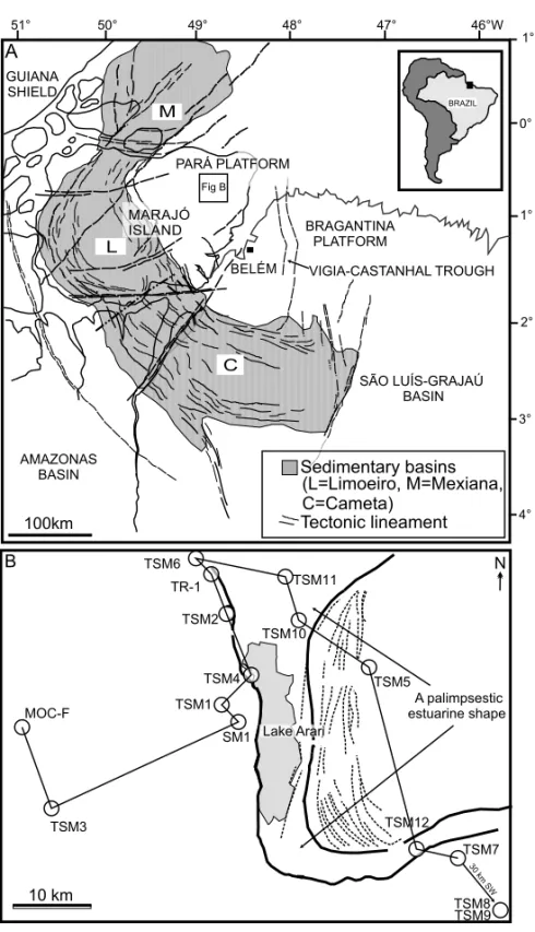
The present work has the main goal of furnishing the stratigraphic framework of late Quaternary deposits of eastern Marajó Island (Fig. 1A) based on core data ob-tained along a nearly 170 km-long transect (Fig. 1B). The lateral distribution of sedimentary units along this sec-tion, combined with radiocarbon ages and morphostruc-tural information derived from remote sensing interpre-tation, helped to demonstrate that fault reactivation is an important process controlling the sediment piling in this flat-lying area of Northern Brazil.
GEOLOGICAL CONTEXT
The Pará Platform, located in the northeast of the State of Pará, Northern Brazil, is bounded by the Vigia-Castanhal trough to the east, Mexiana Sub-Basin to the north, Li-moeiro basin to the southwest, and Cametá Sub-basin to the southeast (Fig. 1A). The three latter Sub-basins are part of the Marajó Graben System, while the Vigia-Castanhal trough represents an offshore extension of the Cametá Sub-basin.
The Marajó Graben System encompasses an area of 1.5×10⁶ km2, and consists of a NW-SE, and then a NE-SW, oriented rift. This structure is defined mostly by NW-SE and NE-SW normal faults reactivated from the Precambrian basement, but E-W to ENE-WSW and NE-SW strike-slip faults have also been recorded (Aze-vedo 1991, Costa and Hasui 1997, Fig. 1A). The rift
ex-perienced two extensional phases. The first one is related to the opening of the Equatorial South Atlantic Ocean in the late Jurassic and early Cretaceous (Szatmari et al. 1987), but a second, and more important, extensional episode took place in the Aptian-Albian transition. In addition, seismic data from all sub-basins of the Marajó Graben System show indications of fault reactivation along strike slip zones throughout the Cenozoic (J.M.C. Villegas, unpublished data).
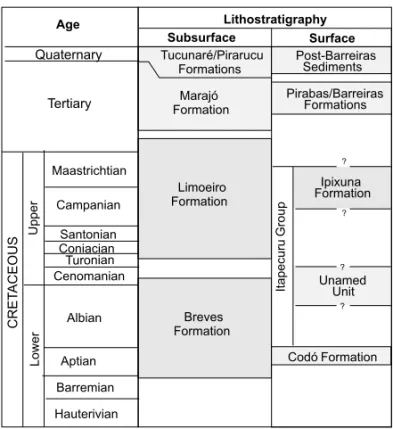
The sedimentary fill of the Marajó rift basins (Fig. 2), mostly based on subsurface data, consists of Creta-ceous to Quaternary fluvial to nearshore deposits (J.M.C. Villegas, unpublished data). Sandstone of the Breves/ Jacarezinho Formations (Aptian-Cenomanian), and silty mudstones of the Anajás Formation (Cenomanian) are overlain by sandstones, mudstones and conglomerates of the Upper Cretaceous to Paleocene Limoeiro Forma-tion. Other Tertiary deposits consist of mixed silici-clastic limestones of the Marajó Formation (Paleocene-Pliocene), as well as sandstones and mudstones of the Tucunaré and Pirarucu Formations of the Pará Group (Quaternary). The latter includes the studied Quaternary deposits in eastern Marajó Island.
METHODS
Lake Arari B
10 km
30km
SW
A palimpsestic estuarine shape
N
A
TSM11
S 1M TSM1 MOC-F
TSM2
TSM4
TSM3
TR-1 TSM6
TSM10
TSM5
TSM12
TSM7
TSM8 TSM9
3° 2° 1° 0° 1°N 48°
49° 50°
51° 47° 46°W
4°
100km
AMAZONAS BASIN
SÃO LUÍS-GRAJAÚ BASIN GUIANA
SHIELD
BRAGANTINA PLATFORM
C L
BRAZIL M
BELÉM
(L=Limoeiro, M=Mexiana, C=Cameta)
Tectonic lineament Fig B
MARAJÓ ISLAND
Sedimentary basins PARÁ PLATFORM
VIGIA-CASTANHAL TROUGH
Fig. 1 – A) Location of the study area in northeastern Marajó Island, Pará Platform, Northern Brazil. B) Location of the studied drills in Lake Arari area, with indication of a morphological feature related to the paleoestuary discussed in the text.
discontinuity surfaces that could be significant for strati-graphic correlation.
The chronology was based on 39 radiocarbon analy-ses undertaken at the Beta Analytic Radiocarbon Dating Laboratory and at the AMS-Labor Erlangen. Samples of peat, wood, and organic sediments were dated using the Accelerator Mass Spectrometer (AMS). The
sam-ples were pre-treated with acid to remove carbonates and weaken organic bonds, washed with alkali to remove sec-ondary organic acids, and then combined with acid again to provide more accurate dating. Conventional14C ages were calibrated to calendar years according to Talma and Vogel (1993) and McCormac et al. (2004).
fea-Hauterivian Barremian Aptian Albian Maastrichtian Campanian Santonian Coniacian Turonian Cenomanian Quaternary Tertiary L o w e r U p p e r C R E TA C E O U S Breves Formation Limoeiro Formation Marajó Formation Tucunaré/Pirarucu Formations Pirabas/Barreiras Formations Post-Barreiras Sediments Unamed Unit It a p e cu ru G ro u p Codó Formation ? ? ? ? Ipixuna Formation
Fig. 2 – Simplified litostratigraphic chart representative of the sedi-mentary sub-basins in the Marajó Graben System.
tures based on remote sensing analysis was performed in selected areas in order to discuss the fault interpreta-tion provided in the geological secinterpreta-tion. This procedure was based on Landsat 5-TM (Ref. 224-060 and 225-061 from INPE, the Brazilian National Institute for Space Research) and Landsat 7-ETM (Ref. 060 and 223-061, GLCF) images, collected on August 2001. Topog-raphy derives from data collected by the Shuttle Radar Topography Mission (SRTM-90 m), freely distributed by the National Aeronautics and Space Administration – NASA.
DESCRIPTION OF SEDIMENTARY UNITS
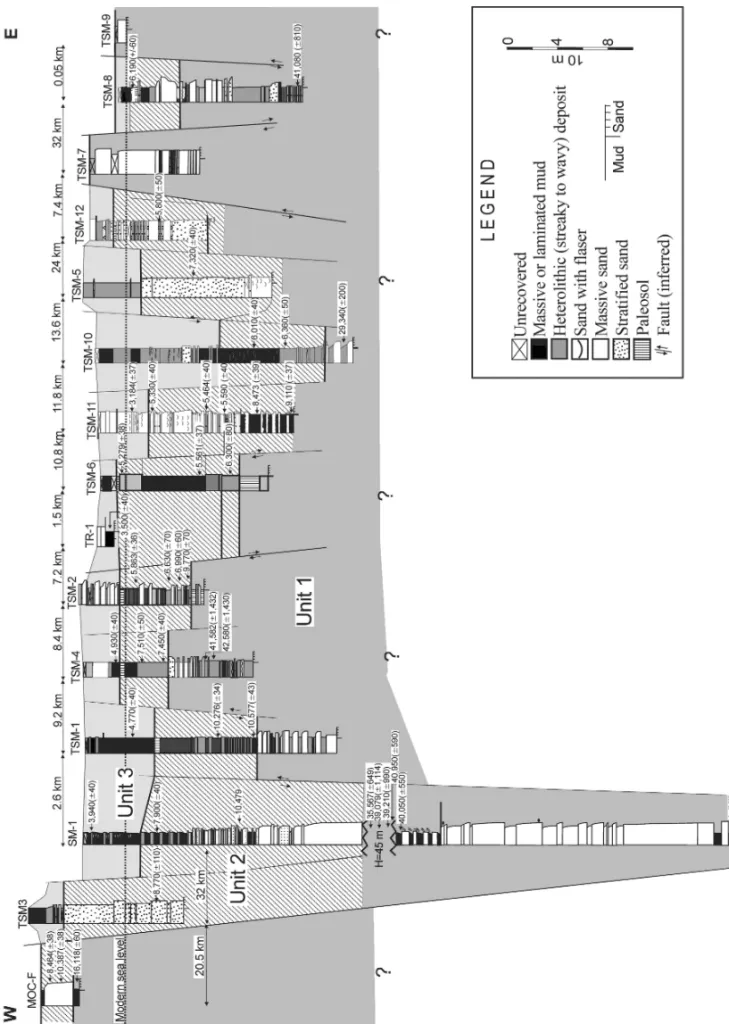
Integration of core information with radiocarbon dat-ing provided the basis for establishdat-ing the stratigraphic framework for the latest Quaternary sedimentation of eastern Marajó Island (Fig. 3). Three broad stratigraphic units were recognized, named herein as units 1, 2 and 3. These are composed by fluvial, lacustrine and estuarine deposits ranging from mud to coarse-grained sands that commonly display variable volumes of plant debris (Ros-setti and Valeriano 2007, Ros(Ros-setti et al. 2007). Analy-sis of the lateral distribution of these units throughout the study area revealed significant thickness variations
for individual units. In general, two depocenters, char-acterized by an overall increased thickness of the sed-imentary units, are present, one at SM-1 and the other one at TSM-10. The first is the deepest one, located at 120 m depth and circa 100 m below the depocenter at drill TSM-10. The geological section presented in Figure 3 depicts several interpreted faults that better accommo-date both the great differences in bed thickness and the lateral distribution of radiocarbon ages. After descrip-tions of individual sedimentary units, provided below, a following section will discuss the fault interpretation suggested in this figure.
Unit 1 occurs at the base of the drills. Its base could not be observed in the cores, but it reaches almost 90 m in drill SM-1. The top of this unit is very irregular, be-ing located at 33 m depth at the main depocenter, while away from this area it can be at the surface (drill TSM-7). The two drills located at the western and eastern extremities of the studied transects display the top of Unit 1 as shallow as 2 and 1 m, respectively. This unit is lacking in the drills TSM-5, TSM-11 and TSM-12. Unit 1 consists of sandy packages that are up to 35 m thick and often organized into numerous fining upward cycles. The sands are massive, cross-stratified, parallel-laminated or display several soft sediment deformation structures, mostly including convolute folds and micro-faults (see Rossetti et al. 2008a for a detailed descrip-tion of these deformadescrip-tion structures). The sandy strata are interbedded with packages up to 10 m thick consist-ing of muds and heterolithic deposits that are frequently organized into coarsening upward cycles. The irregular top surface characterizes a discontinuity surface that, in shallow depths, overlies highly weathered deposits con-sisting of a massive, homogenous, endured and often fer-ruginous nature. Noteworthy is that these strata, which may reach up to 2 m thick, grade downward into deposits displaying primary sedimentary structures. Radiocar-bon ages obtained from Unit 1 range between 55,082 (±12,354) 14C yr B.P. and 16,118 (±80) 14C yr B.P. (Table I).
depth in the drill SM-1, where it occurs 33 m below the modern surface; the drill MOC-F displays Unit 2 at the surface. In general, there is an overall thickness decrease toward the edges of the studied transect. The deposits are lithologically similar to Unit 1, consisting of fining up-ward sand packages that either are interbedded or grade upward into muddy strata. However, there are several places where either sand beds (MOC-F, TSM3, TSM-7, TSM-5, TSM-13) or mud beds (TSM-1, TSM-4, TSM-6, TSM-10) dominate. Deposits underlying the top discon-tinuity surface also have evidence of weathering, being characterized by mottled sands and muds with red and dark yellow colors due to iron staining. The thickness of the weathered deposits, however, is much less than (i.e., only few centimeters thick) in similar deposits observed at the top of Unit 1. Unit 2 records only early to middle Holocene ages, indicated by radiocarbon dates ranging from 10,577 (±43)14C yr B.P. to 5,279 (
±38)14C yr. B.P. (Table I).
The uppermost Unit 3 is, in general, thinner relative to the other ones, with a maximum thickness of 11.5 m, as verified in the drill TSM-10. Away from this area, this Unit becomes thinner, being completely absent in some drills located in the western and eastern extremities of the studied transect (i.e., drills MOC-F, TSM7 and TSM-9). Due to the proximity to the surface, the de-posits are often weathered and mottled in yellow and reddish. Sandy deposits dominate in the drills TSM-2, TSM-7, TSM-11, TSM-1TSM-2, while in the others the prevailing lithologies are muds and heterolithic deposits. Radiocarbon dating recorded ages younger than the mid-dle/early Holocene, ranging from 4,770 (±40) 14C yr B.P. to 3,184 (±37)14C yr B.P. (Table I).
MORPHOSTRUCTURAL CHARACTERIZATION
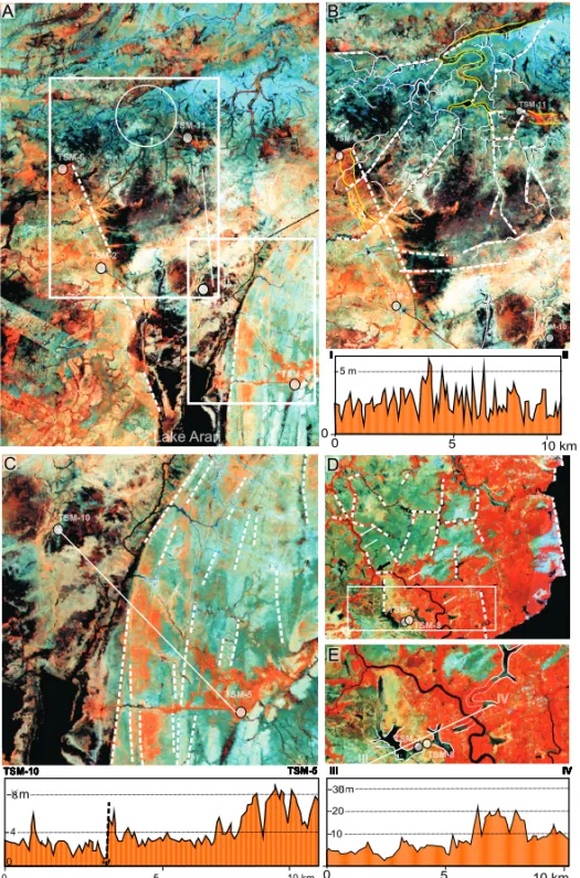
Analysis of the processed Landsat image reveals sev-eral morphostructural lineaments defined by straight drainage segments that are suggestive of fault activity along the areas located among the studied drills. The goal of this section is not to present an extensive descrip-tion of the morphostructural context for the study area. The focus will be on selected areas among and around the studied drills in order to support the existence of tectonic faults suggested by the stratigraphic correlation shown in Figure 3.
The first area to be described is the one between the drills TSM-6 and TSM-11. This area is at the mouth of a large palimpsestic feature related to a paleoestuary that, once abandoned, gave rise to Lake Arari (Rossetti et al. 2007, Fig. 1B). Drills TSM-6 and TSM-11 are lo-cated at the left margin and in the center of this estuary (Fig. 4A,B), respectively. The paleoestuary margin is straight, and a previous work has shown its relation to tectonic faults (Rossetti et al. 2008a). Additionally, the drainage system between these drills, as well as from their adjacencies, is complex, being characterized by an abundance of straight channels that not rarely bifurcate at high angles of, or close to, 90◦. Main, NE-SW
ori-ented straight channels parallel to each other cut across the entire area, reaching the paleoestuary margin. Note-worthy are the drainage anomaly consisting of straight channels that become highly meandering, and the trib-utary channel that is linked to the main stream through a segment of channel much narrower than its average width (Fig. 4B). The prevailing drainage pattern can be classified as angular, with local development of trellis. Furthermore, it is interesting to notice the segments of paleochannels with sharply based edges, defined by the interception of straight modern channels.
The second area relevant to this study locates be-tween the drills TSM-11 and TSM-10, the latter po-sitioned at the center of the paleoestuary, circa 12 km south of drill TSM-11 (Fig. 4B). Likewise the area de-scribed above, this one is also characterized by straight channels connected at angles of 90◦ which define the
prevalence of an angular drainage pattern. However, the most striking feature in this sector is a northward and a southward drainage basin separated by an area crossed by two straight parallel channels showing an E/NE-W/SW orientation. Despite the overall very low topography, digital elevation data suggest slightly higher altitudinal values in this place (see the topographic profile in the lower part of Fig. 4B).
TABLE I
Radiocarbon ages for samples collected from the three stratigraphic units of the study area. STRAT.
Drill Type of Material 14C yr B.P. Cal year B.P. 2-sigma
UNIT calibration (type of analysis)
MOC-F organic sediment 16,118 (+/-80) (AMS) organic sediment 35,587 (+/-649) (AMS) organic sediment 39,079 (+/-1,114) (AMS) organic sediment 39,210 (+/-990) (AMS) organic sediment 40,050 (+/-550) (AMS) 1 organic sediment 40,950 (+/-590) (AMS) organic sediment 40,200 (AMS) TSM4 organic sediment 41,582 (+/-1,432) (AMS) organic sediment 42,580 (+/-1,430) (AMS) TSM8 organic sediment 41,080 (+/-810) (AMS) TSM10 organic sediment 29,340 (+/-200) (AMS) MOC-F organic sediment 8,464 (+/-38) (AMS)
organic sediment 10,387 (+/-38) 7,575-7,447 (AMS) SM1 organic sediment 7,900 (+/-40) 8,800 to 8,600 (AMS)
organic sediment 10,479 (AMS) TSM1 organic sediment 10,577 (+/-43) (AMS) organic sediment 10,276 (+/-34) (AMS)
TSM2 peat 6,630 (+/-70) 7,610 to 7,420 (radiometric) peat 6,990 (+/-80) 7,940 to 7,680 (AMS) peat 9,770 (+/-70) 11,250-11,100 (AMS) TSM3 peat 8,850 (+/-110) 10,220-9,550 (radiometric) TSM4 organic sediment 7,450 (+/-40) 8,360 to 8,180 (AMS)
2 organic sediment 7,510 (+/-50) 8,400 to 8,200 (AMS) TSM6 organic sediment 5,279 (+/-38) 6,031-5,909 (AMS)
organic sediment 5,561 (+/-37) 6,402-6,270 (AMS) peat 6,300 (+/-80) 7,410-7,000 (radiometric) TSM8 peat 6,190 (+/-60) 7,250-6,900 (radiometric) TSM10 organic sediment 6,010 (+/-40) 6,950 to 6,740 (AMS)
organic sediment 6,360 (+/-50 7,420 to 7,170 (AMS) organic sediment 5,330 (+/-40) 6,210 to 5,990 (AMS) TSM11 organic sediment 5,464 (+/-40) 4,349-4225 (AMS)
organic sediment 5,590 (+/-40) 6,440 to 6,300 (AMS) organic sediment 8,473 (+/-39) 7,579-7,448 (AMS) organic sediment 9,110 (+/-37) 8,320-8,222 (AMS) TSM12 organic sediment 5,800 (+/-50) 6,730 to 6,480 (AMS)
SM1 organic sediment 3,940 (+/-40) 4,510-4,470 (AMS)
Km Km
A B
0 5 10 km
0 4 8
A
C
0 5 10 km
10 20 30
D
E
0 5 10 km
5 m
0
of the estuary margin boundary, respectively (see the to-pographic profile in the lower part of Fig. 4C). In addi-tion, the area located to the east of the estuary is dom-inated by a series of NNE-SSW straight sand bars that parallel the estuary margin. These were related to the westward migration of the estuarine channel (Rossetti et al. 2007). Although main water courses in this area flow northwestward, crossing over the sand bars, some channels parallel these sand ridges, configuring an an-gular drainage pattern. The last area to be described is the one around the drills TSM-8 and TSM-9. These drills are located near the western margin of Marajó Is-land (Fig. 4D), in a place that marks a sharp boundary between dense forest over Miocene strata to the west, and savanna over Quaternary deposits to the east. The modern drainage, particularly to the north of the drills, is arranged in an angular to rectangular pattern.
Another remarkable feature in this area is the oc-currence of several elongated lakes that are aligned re-sembling sinuous channels (Fig. 4E). Interestingly is that these lakes show continuity with paleochannel seg-ments. This situation reveals that the lakes are most likely primarily part of a channel system in process of abandonment. Noteworthy is the presence of a NW-SE oriented modern channel to the west of the drills, which varies rapidly from meandering to straight, with the change in pattern taking place at high angles right at the boundary between forest and savanna (Fig. 4E). This contact is marked by a digital topographic gradient up to 15 m (see the topographic profile in the lower part of Figure 4E), which results from the combined effect of vegetation and a true topographic difference, as verified during fieldwork.
DISCUSSION
Both the spatial distribution of the sedimentary units and the morphostructural features described herein are consistent with the interpreted geological section pro-vided for the study area. Tectonic faults were added in order to accommodate the differences in age and in bed thickness among the investigated drills. An alternative interpretation that could also explain the observed differ-ences in age and bed thickness was disregarded herein, based on the following lines of evidence:
1) there is a significant variation in the thickness of the stratigraphic units when all drills are compared, with correlatable beds displaying offsets larger than 30 m;
2) the changes in thickness of the stratigraphic units are not random, but instead they follow a regular pattern of simultaneous increment with respect to the suggested depressed areas;
3) there is a subtle change in unit thickness at some places, with all units being much thicker in drill SM-1;
4) strata recording comparable radiocarbon ages are vertically displaced up to 100 m depth, as occurs with deposits at the bases of the drills SM-1 and TSM-4. This attests the presence of areas with high accommodation rates, in contrast to adjacent areas where sediment accumulation took place relatively at a slower pace; and
5) there is an overall upward reduction in the thick-ness of the sedimentary units, which suggests that the youngest unit was deposited when accommo-dation space was reduced with respect to the older units.
in effect up to the Holocene (Costa et al. 1996, 1997, 2001, Bezerra 2003, Silva 2005).
The morphostructural characterization provided herein is consistent with the presence of faults among the studied drills in eastern Marajó. Tectonic influence is suggested by several features, mostly including: abun-dance of straight channels that are either connected at high angles or are distributed parallel to each other; lo-cally meandering channels that give rise to straight chan-nels; rapid change from large to narrow chanchan-nels; domi-nance of drainage organized into an angular, rectangular or parallel pattern; and presence of segments of pale-ochannels with sharply based edges, defined by the inter-ception of straight modern channels. All these features are regarded as highly suggestive of tectonic influence during the development of drainage systems (Howard 1967, Ouchi 1985, Summerfield 1993).
The area between the drills TSM-11 and TSM-6 displays a set of NE-SW oriented, straight channels that are highly suggestive of major faults. It is interesting to notice that the drill TSM-6, located at the western mar-gin of the paleoestuary, shows stratigraphic units that are positioned at shallower depths with respect to cor-relatable strata from drill TSM-11, this located in the center part of the paleoestuary. This situation is consis-tent with SW-dipping fault planes, as depicted in Fig-ure 3. The two ENE-WSW oriented channels located in an area with slightly higher topography between the drills TSM11 and TSM-10 are also attributed to the in-fluence of faults. This is proposed with basis on their straight course, the parallel arrangement to each other, and the anomalous orientation separating northward and southward flowing channels.
FINAL REMARK
The stratigraphic framework proposed herein for the sedimentary succession in eastern Marajó Island indi-cates that tectonics related to fault reactivation was an important process to preserve the late Quaternary sed-imentary units. Without the influence of this factor, sediment preservation on this low-lying terrain would have been negligible, even considering the influence of global eustatic rises. The sedimentary pile accumulated as a function of fault displacement in this area serves
as an important information source for reconstructing the effect of Quaternary events in low-lying Amazonian areas.
The increasing documentation of Quaternary tec-tonics in Amazonia motivates to look for other areas sim-ilar to Marajó Island, where fault displacement creates enough space to accommodate significant sedimentation. This can provide information for reconstructing the effect of Quaternary events in Northern Brazil.
ACKNOWLEDGMENTS
This work was funded by Fundação de Amparo à Pes-quisa do Estado de São Paulo (FAPESP – Project # 004/ 15518-6), and it had the logistic contribution of the Museu Paraense Emílio Goeldi.
RESUMO
A visão tradicional de que a Amazônia brasileira localiza-se em uma área tectonicamente estável desde o Cretáceo está mudando perante a crescente documentação de reativações de falha, até mesmo durante o Holoceno. Como o registro sedi-mentar respondeu a esses eventos é um tema que permanece por ser abordado com base em dados de campo. Este tra-balho enfatiza a correlação estratigráfica de depósitos quater-nários tardios no leste da Ilha do Marajó, com o objetivo de demonstrar a importância de reativações de falha na origem e preservação desses depósitos. Apesar da localização em área de plataforma de uma margem continental passiva, três unidades estratigráficas estudadas mostram significantes rejeitos verti-cais, que definem dois depocentros, explicados por desloca-mentos tectônicos. Esta interpretação é reforçada por várias feições morfoestruturais relacionadas com falhas localizadas entre os poços estudados. Sem influência tectônica, a preser-vação de sedimentos nesse terreno, caracteristicamente plano, seria imperceptível. Os resultados do presente trabalho mo-tivam a procurar outras áreas tectonicamente influenciadas da Amazônia, que possam ter atuado como sítios de acomodação de sedimentos durante o Quaternário tardio. Esses registros sedimentares têm grande potencial de serem fontes de infor-mações valiosas para auxiliar na reconstrução de eventos geo-lógicos quaternários no norte do Brasil.
REFERENCES
AZEVEDORP. 1991. Tectonic evolution of Brazilian
Equa-torial Continental Margin Basins. PhD Thesis, University of London, London.
ALMEIDA-FILHORANDMIRANDAFP. 2007. Mega cap-ture of the Rio Negro and formation of the Anavilha-nas Archipelago, Central Amazonia, Brazil: evidences in an SRTM digital elevation model. Rem Sens Envir 110: 387–392.
BEMERGUYRL, COSTAJBS, HASUIY, BORGESMSAND
SOARES JR AV. 2002. Structural geomorphology of the Brazilian Amazon region. In: KLEINEL, VASQUES
MLANDROSACOSTALT (Eds), Contribuições à
Geo-logia da Amazônia: SBG-Núcleo Norte, Belém, PA, p. 245–258.
BEZERRAPEL. 2003. Compartimentação morfotectônica do interflúvio Solimões-Negro. PhD Thesis, Universidade Federal do Pará, Belém, PA.
COSTAJBS ANDHASUI Y. 1997. Evolução geológica da Amazônia. In: COSTAMLANDANGÉLICARS (Eds),
Contribuições à Geologia da Amazônia: SBG, Belém, PA, p. 15–19.
COSTA JBS, BORGESMS, BEMERGUY RL, FERNANDES
JMG, COSTAJRANDCOSTA ML. 1993. A evolução cenozóica da região de Salinópolis, nordeste do Estado do Pará. Geociências 12: 373–396.
COSTAJBS, HASUIY, BORGESMSANDBEMERGUYRL. 1995. Arcabouço tectônico mesozóico-cenozóico da re-gião da calha do Amazonas. Geociências 14: 77–83. COSTAJBS, BERMEGUYRL, HASUIY, BORGESMS, FER
-REIRAJRCRP, BEZERRAPEL, COSTAMLANDFER
-NANDESJMG. 1996. Neotectônica da região
amazônica-aspectos tectônicos, geomorfológicos e deposicionais. Geonomos 4: 23–44.
COSTAJBS, BEMERGUYRL, HASUIYANDBORGESMS. 2001. Tectonics and paleogeography along the Amazon River. J South Am Earth Sci 14: 335–347.
COSTA ML, MORAES EL, BEHLING H, MELO JCV, SIQUEIRANVM ANDKERN DC. 1997. Os
sedimen-tos de fundo da Baía de Caxiuanã. In: LISBOA PLB (Ed), Caxiuanã: Populações Tradicionais, Meio Físico e Diversidade Biológica: Mus Par Em Goeldi, Belém, PA, p. 121–137.
COSTA ML, KERN DC, BEHLING H AND BORGES M. 2002. Geologia. In: LISBOAPLB (Ed), Caxiuanã: Popu-lações Tradicionais, Meio Físico e Diversidade Biológica: Mus Par Em Goeldi, Belém, PA, p. 179–206.
HOWARDAD. 1967. Drainage analysis in geologic interpre-tation: A summation. Am Assoc Petrol Geol Bull 51: 2246–2259.
IGREJAHLS. 1992. Aspectos Tectono-sedimentares do
Fa-nerozóico do Nordeste do Estado do Pará e Noroeste do Maranhão. Doctoral Thesis, Universidade Federal do Pará, Belém, PA.
MCCORMACFG, HOGGAG, BLACKWELLPG, BUCKCE,
HIGHAMTFGANDREIMERPJ. 2004. Southern Hemi-sphere Calibration, 0-11.0 Cal kyr BP. Radiocarbon 46: 1087–1092.
MIOTTO JA. 1993. Sismicidade e zonas sismogênicas do Brasil. Doctoral Thesis. Universidade Estadual Paulista, Rio Claro, SP.
OUCHI S. 1985. Response of alluvial rivers to slow active
tectonic movement. Geol Soc Am Bull 96: 504–515. ROSSETTIDFANDVALERIANOMM. 2007. Evolution of
the lowest Amazon basin modeled from the integration of geological and SRTM topographic data. Catena 70: 253–265.
ROSSETTIDF, VALERIANOMMANDTHALLES M. 2007. An abandoned estuary within Marajó Island: implications for Late Quaternary paleogeography of Northern Brazil. Est and Coasts 30: 813–826.
ROSSETTIDF, GÓESAM, VALERIANOMMANDMIRAN -DAMCC. 2008a. Quaternary tectonics in a passive
mar-gin: Marajó Island, Northern Brazil. J Quat Sci 23: 121–135.
ROSSETTIDF, VALERIANOMM, GÓESAMANDTHALLES
M. 2008b. Paleodrainage in Marajó Island (Northern Brazil) and its relation to Holocene relative sea-level. The Holocene 18: 923–934.
SILVACL. 2005. Análise da tectônica Cenozóica da região
de Manaus e adjacências. Doctoral Thesis, Universidade Federal do Amazonas, Manaus, AM.
SUMMERFIELDMA. 1993. Global geomorphology: an
intro-duction to the study of landforms. Logman Scientific & Technical, New York, USA.
SZATMARIP, FRAÇOLIN JBL, ZANOTTO OAND WOLFF
S. 1987. Evolução tectônica da margem equatorial bra-sileira. Rev Bras Geoc 17: 180–188.