$*,60HWKRGRORJLFDO)UDPHZRUN%DVHG2Q)X]]\6HWV
7KHRU\)RU/DQG8VH0DQDJHPHQW
*SOZX_1[XZKTKX
'MXUVN_YOIGR8KYKGXIN/TYZOZ[ZK
-XG`NJGTYQ_VXUYVKIZ9Z6KZKXYH[XM
8[YYOG
KSGOR )U[XZKTK&*1YVHKJ[
<RGJOSOX(GJKTQU
9Z6KZKXYH[XM9ZGZK:KINTOIGR;TO\KXYOZ_
6UROZKINTOINKYQGOGYZX9Z6KZKXYH[XM
8[YYOG
KSGOR HGJKTQU&\KTZ[XKYVHX[
Abstract
This paper considers a GIS methodological framework based on fuzzy sets theory for land use management. Some principles of development of the GIS methodological framework are formu-lated. Applications of the GIS methodological framework are designed. In particular GIS knowledge management fuzzy models for analysis of soil commutative contamination by heavy metals, for the study of soil acidity, and for evaluation of soil conservation actions are obtained.Keywords: geoinformation systems, fuzzy sets theory, GIS knowledge management, land use prediction models
1 Introduction
Fuzzy set theory is a useful tool for dealing with knowledge about territory, taking into account uncer-tainty in the interpretation of quantitative information on land use, particularly when this is automated in Geo-graphic Information Systems (GIS). These and other problems of integration of fuzzy set methods to a GIS environment for land use are discussed in many top-ranking international journals [13-16]. The applications of knowledge management for land use, which may be generated from, or adapted to, fuzzy sets theory and fuzzy logic, are wide-ranging: numerical classification of soil and mapping, land evaluation, modeling and simula-tion of soil physical processes, soil quality indices and fuzzy measures of imprecisely defined soil phenomena.
This paper shows a methodological framework using GIS for knowledge management for land, based on the fuzzy set theory.
The rest of this paper is organized as follows. Section 2 gives a brief overview of how to consider knowledge management within a GIS framework for the land use
application domain. Section 3 introduces the definitions of the fuzzy sets theory which are used in this work. Section 4 shows examples of the use of the frame-work for real data, in Russia. Finally, section 5 presents conclusions and directions of ongoing work.
2 Conception of GIS knowledge
man-agement for land use
When one considers a methodological framework of GIS knowledge management for land use based on fuzzy sets theory, the most appropriate form of discussion is not detailed consideration, but rather high-level principles. Some principles for creating such a framework are listed below:
2. The result of combining these approaches is a hy-brid set of models to be applied to the data. These hyhy-brid solutions will be named in this paper GIS knowledge management fuzzy models.
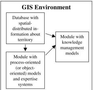
3. A GIS knowledge management fuzzy model must be built considering at least the following (software) modules (see Figure 1):
A module which contains a library of process-oriented (or object-process-oriented) models and expertise sys-tems that are integrated into the GIS environment.
A module with fuzzy algorithms that is integrated into the GIS environment.
The library of process-oriented (or object-oriented) models and expertise systems is intended to create new data, new information and new knowledge. These new data, information and knowledge are built from applying the fuzzy algorithms to the data in the spatial database, using the process oriented models.
Figure 1: Structure of the GIS knowledge management fuzzy model.
3 Fuzzy sets theory
It is well known that many elements of land plot properties (soil, fertility of soil, microclimate, etc) have
The fuzzy sets theory originated in the work of Lotfi Zadeh. According to Zadeh [11,12] “The theory of fuzzy sets is, in effect, a step toward a rapprochement between the precision of classical mathematics and the pervasive imprecision of the real world - a rapprochement born of the incessant human quest for a better understanding of mental processes and cognition”.
Fuzzy sets theory is a mathematical method used to characterize and propagate uncertainty and imprecision in data and functional relationships. Fuzzy sets are espe-cially useful when insufficient data exist to characterize uncertainty using standard statistical measures (e.g., mean, standard deviation, and distribution type).
An underlying philosophy of the fuzzy sets theory is to provide a strict mathematical framework, where the imprecise conceptual phenomena in decision making may be precisely and rigorously studied, in particular for knowledge management. The fuzzy sets theory includes fuzzy mathematics, fuzzy measures, fuzzy integrals, etc.
Fuzzy logic is a minor aspect of the whole field of fuzzy mathematics. In classical sets theory, the member-ship of a set is defined as true or false, 1 or 0. Member-ship of a fuzzy set, however, is expressed on a continuous scale from 1 (full membership) to 0 (full non-membership). We now introduce some formal defini-tions, which we will use later on [4, 12]:
Definition 1. Let X be a set (universe). D is called a fuzzy subset of X if D is a set of ordered pairs: D = [(x,
µD(x)), x ∈ X], where µD(x) is the grade of membership of
X in D. µD(x) takes its values in the closed interval [0,1]. The closer µD(x) is to 1, the more x belongs to D; the closer it is to 0 the less it belongs to D. If [0,1] is replaced by the two element set {0,1}, then D can be regarded as a subset of X.
Definition 2. The α level set of fuzzy subset D is the set of those elements that have at least a membership:
D(α) = [x: µD(x)≥ α]. A fuzzy subset n* is called normal if there is at least one z such that µn* (z) = 1
Definition 3. A fuzzy subset n* of the set of real numbers is called convex if
for each real number (x,y) u
∈
[0,1] one has:mn* (ux + (1 - u)y)
≥
min(mn*(x), mn*(y)]Definition 4. A fuzzy subset n* is called a fuzzy
GIS Environment
Module with process-oriented
(or object-oriented) models
and expertise systems Database with
spatial-distributed in-formation about
territory Module with knowledge management
4 Applications of the GIS
methodo-logical framework based on fuzzy
sets theory for land use
The GIS methodological framework based on fuzzy sets theory for land use management was considered by Kurtener et al. [5-7]. Some new results are shown in this section.
4.1. Analysis of soil contamination by heavy
metals
In the analysis of soil contamination by heavy metals it is very important to obtain thematic maps describing the index of cumulative soil contamination. Application of the GIS methodological framework with this aim gives a possibility for solving of the problem.
A GIS knowledge management fuzzy model includes two sub-models. The first describes an index of soil con-tamination by i - pollutant with the following equation:
0: C < th/3
µi = 1,5C / th –0,5: th/3 < C < th (1)
1: C > th
where th is threshold of i - pollutant, C is the current value of this pollutant.
The second sub-models describing index of cumula-tive soil contamination
•
com is based on the use of theoperation of algebraic sum for fuzzy sets [4]
•
com =•
1 ⊕•
2 ⊕ ... ⊕•
k (2)where
•
j is index of soil contamination by i – pollutant.On the basis of the model, a software oriented for use with MapInfo Professional GIS software, version 4,0 has been designed.
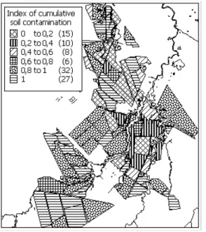
The approach was used for management of agrarian territories located in suburbs of St. Petersburg. In par-ticular, values of indices of soil contamination by differ-ent heavy metals and their cumulative affects are calcu-lated and mapped automatically (Figures 2 – 4).
Figure 2: Thematic map describing index of soil contami-nation by copper.
Figure 4: Thematic map describing index of cumulative soil contamination
4.2 Multiple assessment of land parcels for
soil conservation
The second example of the use of the methodological framework concerns assessment of land parcels, having soil conservation as a goal. In the process of monitoring natural resources it is a need to estimate an effect of soil conservation actions taking into account ecological, agri-cultural, and socio-economic factors.
In this case, the GIS knowledge management fuzzy model is based on a multicriteria theory of multiple as-sessment of landscape parcels and choice of alternatives [3]. In particular, consider there is a set of m landscape plots as described in equation (3):
A={a1, a2, ... am} (3)
and a fuzzy set of criteria described in (4):
C={µc(a1)/a1, µc(a2)/a2, ..., µc(am)/am}, (4)
where the membership function µc(ai) expresses the ex-perts knowledge about grade of landscape plots satisfac-tion to criteria C.
If there are several criteria C1, C2, ..., Cn, and the coef-ficients of relative significance of these criteria are
α
1,
α
α
where is
,
*
ii
C
C
i=
α
0
,
1
.
1 1 ; ,1
∑
=
=
≥
=
ni n n
i i
i
α
α
The coefficients of relative significance
α
iare found by comparison of pairs of criteria. To start this assess-ment, these criteria are initially entered into matrixB
.
Elements bij of matrix
B
are defined in Table 1 and must satisfy the conditions: bij = 1, bij = 1/bji . For example, if user is estimated relative importance of criteria Ciand Cj as equilibrium so element bij = 1; if user is estimated rela-tive importance of criteria Ciand Cj as great importance so element bij = 7.Relative importance of
criteria Ciand Cj Element bij
Equilibrium 1 Very of little importance 3 Of little importance 5 Importance 7 Great importance 9 Intermediate value 2, 4, 6, 8
Table 1. Scale of evaluation of relative importance of criteria
Next, the self-vector of the matrix
B
is determined from the solution of equation (5):Bw = λmax w (5)
where
λ
max is maximum of self-number of the matrix. The solution sought is given byα
i= n w
i , wheren
is apredefined number of criteria.
The mathematical operation of intersection of fuzzy sets is in agreement with operation of the search for minimum of the membership functions of these fuzzy sets. In this specific problem, preference is given to land plots that are characterized by the greatest value of the membership function.
Let us consider an example of multiple assessment of soil conservation actions by this approach. We will pro-ceed to analyze the territory located in the suburbs of St. Petersburg. The plots submitted for analysis are shown on Figure 4 with membership function = 1. They differ in types of soil type, soil hydrology, microclimate, proc-esses of soil degradation, procproc-esses of soil contamination, crop rotation, etc.
Social criteria (SC).
With the TC we try to evaluate soil conservation ac-tions and the feasibility of re-making the area. TC =1, if the action is fully suitable; TC = 0, if it is not.
With the EC we evaluate the economical efficiency of soil conservation actions. EC =1, if the action is eco-nomically efficient; EC = 0, if it is not.
With the ECC we evaluate the environmental addi-tional negative effect of the soil conservation actions. ECC =1, if the environmental additional negative effect is absent, ECC = 0, if it is not.
Figure 5: Integral index of evaluation of soil conservation action for selected land plots.
SC provides an estimate of the social factors. SC =1, if the human response is positive; SC = 0, if the human response is negative.
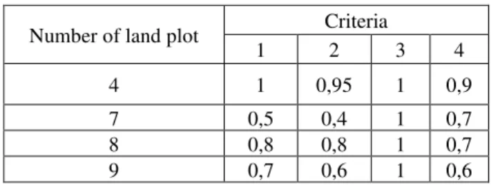
In practice, the values of the four criteria would be as-signed by an expert panel. In this example we use the values given in Table 2.
Criteria Number of land plot
1 2 3 4 4 1 0,95 1 0,9 7 0,5 0,4 1 0,7 8 0,8 0,8 1 0,7 9 0,7 0,6 1 0,6
Table 2. Values of the 4 criteria assigned by an expert panel.
The coefficients of relative significance
α
iare found by comparison of pair of criteria. In particular, matrix Bwas reconfigured, as shown in (6)
1 4 / 1 6 / 1 7 / 1
4 1 4 / 1 6 / 1
6 4 1 5 / 1
7 6 5 1
=
B (6)
Components of self-vector of the matrix with
λ
max = 4,390 are:w
1 = 0,619;w
2 = 0,235;w
3 = 0,101;w
4 = 0,045. Coefficients of relative significance of criteria are:α
1 = 2.48;α
2 = 0,94;α
3 = 0,4;α
4 = 0,18.On the basis of the fuzzy model, a software oriented for use with MapInfo Professional GIS software, version 4,0 has been designed. By this, software values of inte-gral index of multiple assessment of soil conservation action for selected land plots are calculated and mapped automatically (Figure 5). In particular from Figure 5 it follows that priority should be given to the land plot where the index of multiple assessment > 0,9.
4.3 Analysis of soil acidity
It is well known, that soil acidity (pH) is of one of most important characteristic of soil. Also there is infor-mation that agricultural plants may be classified roughly according to their dependence to pH according to three classes (first approximation):
(Class 1) 6 < pH <7;
(Class 2) 5 < pH <6; (6) (Class 3) 4 < pH <5.
The GIS knowledge management fuzzy model is based on the theory developed by Bogardi et al. [2]. Let
R and L denote the pH of plot and pH for one of these three classes respectively, described by triangular fuzzy numbers (Figure 6).
Figure 6: Fuzzy number for plots (R) and 3 fuzzy numbers for 3 class of plants.
The fuzzy number Z is obtained by the subtraction operation between R and L:
Z(α) = R(α) - L(α), ∀α∈ [0,1]. (7) Using fuzzy arithmetic the membership function of the fuzzy number Z(α) = [Z1(α), Z2(α)] can be computed from the level sets using the formulas in (8):
Z1(α) = R1(α) - L2(α),
Z2(α) = R2(α) - L1(α), ∀α∈ [0,1] (8) The conformity between pH of a plot and pH of one of classes occurs when R(α) > L(α), i. e. Z(α)>0. The event Z(α) > 0 implies compatibility. To define a meas-ure to determine the compatibility under such circum-stances, we propose a fuzzy compatibility index Co as follows in equation (9):
∫
∫
>=
z z
o
z z
dz
z
dz
z
Co
)
(
)
(
µ
µ
(9)
Here µz(z) is membership function of fuzzy number Z.
On the basis of the model, a software oriented for use with MapInfo Professional GIS software, version 4,0 has been designed.
The approach was used for management of agrarian territories located in the suburbs of St. Petersburg. In
Most of the territory is suitable for agricultural plants of the first group (Figure 8).
Figure 7: Thematic map describing index of correlation between acidity of land plots and requirements of agricultural
6 Conclusions
This paper presented a GIS methodological frame-work based on fuzzy sets theory for land use manage-ment.
It has discussed three applications of the GIS meth-odological framework. Recently we have applied this framework to several other applications. In particular, for evaluation of cumulative influence of consequence of flooding [8] and for multiple assessment of the territorial prophylactic action in the design of strategy of using the health resources [9]. Currently, we have developed an application for the determination of priority for the resto-ration of burned areas.
The further development of this approach could cre-ate a methodological framework for GIS oriented for social, economical and environmental support of deci-sion-making processes.
References
[1] M. Abbott. Introducing hydroinformatics. Jour-nal of Hydroinformatic.s 1(1):3-20, 1999.
[2] I. Bogardi, A. Bardossy, M.D. Mays, L. Duck-stein. Risk Assessment and Fuzzy Logic as Ra-lated to Environment. Data Reliability and Risk Assessment in Soil Interpretation.SSSA Special Publication. 47:81-97, 1996.
[3] A.N. Borisov,. O.A. Krumberg, I.P. Federov. Decision-making on the base of fuzzy models. Zinatre Publ. Riga. 1990.
[4] A. Kaufmann, M. Gupta Fuzzy mathematical models in engineering and management science. Amsterdam. Elsevier Science, 1988.
[5] D. Kurtener, V. Badenko.. Questions of integra-tion of some ecological models into geoinforma-tion system. In Proceeding of 21st Urban Data Management Symposium. CD-ROM, Theme V, 1999.
[6] D. Kurtener, G. Richard, V. Badenko.. Theoreti-cal description of heat and water flow in soil taking into account soil tillage. In Agrophysical and Ecological Problems Of Agriculture in The 21st Century. 1:29-53. 1998
[7] D.A. Kurtener, V.L. Badenko. Use of geographi-cal information systems (GIS) in agrophysics. In Proceeding on Flow and deformation in biology
and environment. Prague, pages 34-39, 1998
[8] D. Kurtener and V. Badenko. Questions of inte-gration of some ecological models into geoin-formation system. In Proceedings of UDMS’99 on Information technology in the service of local government planing and management. Venice, Italy, pages 21-23, 1999.
[9] Dmitry Kurtener, Viktor Yakushev, Vladimir Badenko, Elaheh Pourabbas. Development of methodology of multiple assessment of land-scape parcels on the base fuzzy models inte-grated into GIS environment. R. 1, St. Peters-burg, Russia, 23p. 1999.
[10] V.P. Yakishev, D.A.. Kurtener, N.V. Arefiev, V.L. Badenko, N.M. Khimin, T.I. Prokof’eva and L.K. Shvetsova. Use of geographical infor-mation systems (GIS) in agrophysics. Russian Agricultural Science. 2:52-54. 1999.
[11] L.A. Zadeh. Fuzzy sets. Inform. Control. 8(3):338-353, 1965
[12] H.J. Zimmerman. Fuzzy set theory and its appli-cation. MA, 1985
[13] X.Y. Chen. A multivatiable analysis of grid data as a soil classification and mapping tool: a case study of a homogeneous plain in Vagia, Viotia, Greece. Geoderma. 77(1):63-81, 1997.
[14] Alex McBratney, Inakwu, O.A. Odeh. The ap-plication of fuzzy sets in soil science: fuzzy logic, fuzzy measurements and fuzzy decisions.
Geoderma. 77(2-4):85-113. 1997.
[15] R.M. Lark, H.C. Bolam. An uncertainty in the prediction and interpretation of spatially variable data on soils. Geoderma. 77(2-4):263-282, 1997.