SED
7, 2735–2773, 2015Spatial evolution of Zagros collision zone
in Kurdistan
S. Sadeghi and A. Yassaghi
Title Page
Abstract Introduction
Conclusions References
Tables Figures
◭ ◮
◭ ◮
Back Close
Full Screen / Esc
Printer-friendly Version Interactive Discussion
Discussion
P
a
per
|
Discussion
P
a
per
|
Discussion
P
a
per
|
Discussion
P
a
per
|
Solid Earth Discuss., 7, 2735–2773, 2015 www.solid-earth-discuss.net/7/2735/2015/ doi:10.5194/sed-7-2735-2015
© Author(s) 2015. CC Attribution 3.0 License.
This discussion paper is/has been under review for the journal Solid Earth (SE). Please refer to the corresponding final paper in SE if available.
Spatial evolution of Zagros collision zone
in Kurdistan – NW Iran, constraints for
Arabia–Eurasia oblique convergence
S. Sadeghi and A. Yassaghi
Department of Geology, Tarbiat Modares University, Tehran, Iran
Received: 1 August 2015 – Accepted: 20 August 2015 – Published: 22 September 2015
Correspondence to: A. Yassaghi ([email protected])
SED
7, 2735–2773, 2015Spatial evolution of Zagros collision zone
in Kurdistan
S. Sadeghi and A. Yassaghi
Title Page
Abstract Introduction
Conclusions References
Tables Figures
◭ ◮
◭ ◮
Back Close
Full Screen / Esc
Printer-friendly Version Interactive Discussion
Discussion
P
a
per
|
Discussion
P
a
per
|
Discussion
P
a
per
|
Discussion
P
a
per
|
Abstract
Stratigraphy, detailed structural mapping and crustal scale cross section of the NW Zagros collision zone evolved during convergence of the Arabian and Eurasian plates were conducted to constrain the spatial evolution of the belt oblique convergence since Late Cretaceous. Zagros orogeny in NW Iran consists of the Sanandaj–Sirjan, Gaveh
5
Rud and ophiolite zones as internal, and Bisotoun, Radiolarite and High Zagros zones as external parts. The Main Zagros Thrust is known as major structures of the Za-gros suture zone. Two stages of deformation are recognized in the external parts of Zagros. In the early stage, presence of dextrally deformed domains beside the re-versely deformed domains in the Radiolarite zone as well as dextral-reverse faults in
10
both Bisotoun and Radiolarite zones demonstrates partitioning of the dextral trans-pression. In the late stage, southeastward propagation of the Zagros orogeny towards its foreland resulted in synchronous development of orogen-parallel strike-slip and pure thrust faults. It is proposed that the first stage related to the late Cretaceous oblique obduction, and the second stage is resulted from Cenozoic collision.
Ceno-15
zoic orogen-parallel strike-slip component of Zagros oblique faulting is not confined to the Zagros suture zone (Main Recent) but also occurred in the more external part (Marekhil–Ravansar fault system). Thus, it is proposed that oblique convergence of Arabia–Eurasia plates occurred in Zagros collision zone since the Late Cretaceous.
1 Introduction
20
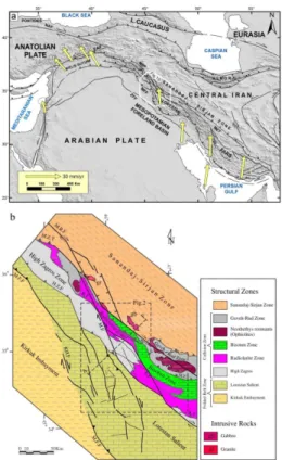
As an active orogeny, Zagros is evolving through the convergence of the Arabia and Eurasia plates (Fig. 1). Zagros collision zone in NW Iran consists of the Sanandaj– Sirjan, Gaveh Rud and Ophiolite zones as internal, and Bisotoun, Radiolarite and High Zagros zones as external parts (Fig. 1b). Zagros orogeny started from obduction of the Neotethys Oceanic crust upon the Arabian Plate in Late Cretaceous (Gidon et al.,
25
SED
7, 2735–2773, 2015Spatial evolution of Zagros collision zone
in Kurdistan
S. Sadeghi and A. Yassaghi
Title Page
Abstract Introduction
Conclusions References
Tables Figures
◭ ◮
◭ ◮
Back Close
Full Screen / Esc
Printer-friendly Version Interactive Discussion
Discussion
P
a
per
|
Discussion
P
a
per
|
Discussion
P
a
per
|
Discussion
P
a
per
|
Continent collision of Arabia with the Central Iran (Braud, 1987; Berberian, 1995; Mc-Quarrie et al., 2003). Late Cretaceous obduction caused deformation at the northeast-ern margin of the Arabian Plate or Neotethys passive margin, (i.e., the Bisotoun and Radiolarite zones) (Gidon et al., 1974; Kazmin et al., 1986; Agard et al., 2005) while Cenozoic collision caused southwest-ward propagation of Zagros orogeny toward its
5
external (Folded Belt zone) (Falcon, 2010; Berberian, 1995; Hessami et al., 2010). GPS measurements show that the recent Arabian Plate movement in relation to Central Iran is oblique in Iran and Iraq (Vernant et al., 2004). Transpressional zones and strike-slip faults in Zagros are likely manifestations of the oblique convergence, but their spatial and temporal evolution and their distribution across the Zagros remain
10
controversial. It is generally believed that the major belt parallel (Main Recent Fault (MRF)) and transverse faults (Kazerun, Karebas, Sabzpoushan and Sarvestan faults) accommodate almost all strike-slip component of the Zagros orogeny during Cenozoic continent-continent collision (Berberian, 1995; Talebian and Jackson, 2002; Allen et al., 2004; Authemayou et al., 2006; Hatzfeld et al., 2010). Similarly, ductile transpression
15
were also proposed for the evolution of the Zagros internal parts (Sanandaj–Sirjan Zone) (Mohajjel et al., 2000, 2003; Sarkarinejad, 2007; Sarkarinejad and Azizi, 2008). However, few and sparse structural data is present to constrain evolution of Zagros collision zone by oblique convergence since Late Cretaceous.
In this paper, stratigraphy, detailed structural mapping and crustal scale cross section
20
of Zagros collision zone were conducted to constrain the spatial evolution of Zagros oblique convergence. To achieve it, the Bisotoun, Radiolarite and High Zagros zones (Fig. 1) as the Zagros external parts in Kurdistan area (NW of Iran) are investigated. Spatial constrain on the oblique convergence of the Zagros collision zone in Cenozoic during its southwest-ward propagation followed by development of transverse
strike-25
SED
7, 2735–2773, 2015Spatial evolution of Zagros collision zone
in Kurdistan
S. Sadeghi and A. Yassaghi
Title Page
Abstract Introduction
Conclusions References
Tables Figures
◭ ◮
◭ ◮
Back Close
Full Screen / Esc
Printer-friendly Version Interactive Discussion
Discussion
P
a
per
|
Discussion
P
a
per
|
Discussion
P
a
per
|
Discussion
P
a
per
|
2 Tectonic setting
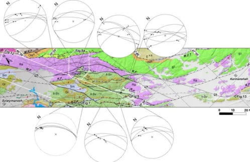
Zagros orogen is generally comprises the Sanandaj–Sirjan zone as internal and the Za-gros Fold–Thrust Belt as external parts, separated by the Main ZaZa-gros Thrust (Falcon, 1974; Berberian, 1995; Mohajjel et al., 2000; Agard et al., 2005). In Kurdistan area (NW Iran), Zagros orogeny composed of seven zones, as Sanandaj–Sirjan, Gaveh
5
Rud, Ophiolites as internal, and Bisotoun, Radiolarite, High Zagros and Folded belt zones as external parts (Fig. 1b). These seven zones are inherited from the Permian– Triassic extensional events related to the Neotethys opening and Late Cretaceous to Cenozoic compressional events. Though the Main Zagros Thrust separates partly the Ophiolites, Gaveh Rud and Sanandaj–Sirjan zones from the Bisotoun, Radiolarite and
10
High Zagros zones, but could not be considered as suture zone (Nemati and Yassaghi, 2010). Therefore, in this study we use the term “Collision Zone” for the Sanandaj–Sirjan zone, Gaveh Rud volcanic arc, Ophiolite, Bisotoun platform, Radiolarite and High Za-gros zones (Fig. 1b).
Ophiolites, Gaveh Rud and Sanandaj–Sirjan zones as internal parts of the Zagros
15
orogeny are accumulated to the Arabian Plate during the closure of the Neotethys Ocean. Ophiolite zone is the remnant of the Neotethys oceanic crust obducted on the Arabian Platform in Late Cretaceous to early Paleocene (Kazmin, 1986; Agard et al., 2011; Karim et al., 2011). Gaveh Rud zone comprises of volcano-sedimentary units collided with the margin of the Arabian Plate in Oligocene-early Miocene (23–16 Ma)
20
(Ali et al., 2013). The more Iraq’s part of this zone is named as Walash and Naopurdan groups (Ali et al., 2013) while the more Iranian’s part is known as Gaveh Rud (Homke et al., 2010; Vergés et al., 2011). Sanandaj–Sirjan zone as the metamorphic core of the Zagros orogeny has a long lived deformation and magmatism of Mesozoic subduction (Mohajjel et al., 2000; Azizi and Jahangiri, 2008) and Cenozoic collision (Berberian,
25
1995; McQuarrie et al., 2003).
SED
7, 2735–2773, 2015Spatial evolution of Zagros collision zone
in Kurdistan
S. Sadeghi and A. Yassaghi
Title Page
Abstract Introduction
Conclusions References
Tables Figures
◭ ◮
◭ ◮
Back Close
Full Screen / Esc
Printer-friendly Version Interactive Discussion
Discussion
P
a
per
|
Discussion
P
a
per
|
Discussion
P
a
per
|
Discussion
P
a
per
|
thick shelf deposit from Permian–Triassic to Cenozoic with some facies changes and discontinuities (James and Wynd, 1965; Koop and Stoneley, 1978; Harison and Frost, 1987; Beydoun, 1991). The major differences of the Lorestan Salient and Dezful Em-bayment arise from difference in the basal décollement rheology during deformation as well as variations on fold style due to the effect of the middle décollements (Sherkati
5
et al., 2006; Farzipour-Saein et al., 2009, 2014)
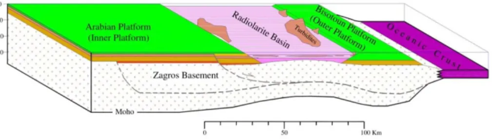
Bisotoun and Radiolarite zones are also resulted from thinning of the Arabian Plate during the Neotethys opening in Permian–Triassic time (Searle and Graham, 1982; Kazmin et al., 1986; Fontaine et al., 1989). Bisotoun zone (or Bisotoun platform) com-posed of thick carbonate deposits at the northeastern rim of the Arabian Plate.
Radi-10
olarite zone with 50 to 70 km widens, developed as marginal basin (Radiolarite basin) between the Bisotoun Platform and the rest of Arabian platform (i.e., High Zagros and Folded Belt zones) (Ricou, 1976; Wrobel-Daveau et al., 2010; Vergés et al., 2011) (Figs. 1b and 2).
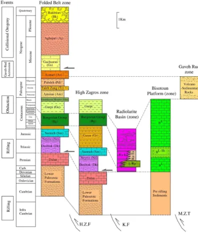
3 Stratigraphy of the Zagros collision zone
15
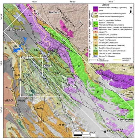
stratigraphic columns of sedimentary basins on Zagros collision zone in the Kurdistan area (Bisotoun platform, Radiolarite basin, High Zagros zone and Lorestan salient) are drawn (Fig. 3) using present stratigraphic columns (e.g., Farzipour-Saein et al., 2009; Motiei, 1993) and Radiolarite Basin in Iran (Gharib et al., 2010) and Iraq (Jassim and Buday, 2006) as well as field measurements during this study (A to F line of cross
20
section in Fig. 2).
Detailed study on stratigraphic columns of the Lorestan salient, Radiolarite and Biso-toun platforms as to the timing of the main extensional and compressional events can be addressed as follow:
– From Triassic to Jurassic period, Radiolarite basin existed at the northeast rim of
25
SED
7, 2735–2773, 2015Spatial evolution of Zagros collision zone
in Kurdistan
S. Sadeghi and A. Yassaghi
Title Page
Abstract Introduction
Conclusions References
Tables Figures
◭ ◮
◭ ◮
Back Close
Full Screen / Esc
Printer-friendly Version Interactive Discussion
Discussion
P
a
per
|
Discussion
P
a
per
|
Discussion
P
a
per
|
Discussion
P
a
per
|
and Arabian (James and Wynd, 1965; Koop and Stoneley, 1978; Sherkati et al., 2006) platforms. The Radiolarite basin is filled by up to 300 m of rhythmically thin-bedded cherts alternating with millimeter in thickness of shales (Gharib et al., 2010) (Fig. 3).
– During Early Cretaceous, the thickness of the Garau Formation pelagic sediments
5
increased from 200 m in the Folded Belt zone to about 1200 m in High Zagros zone. This variation is more likely related to normal mechanism of the High Zagros Fault (HZF) and other normal faults in High Zagros zone. At the same time, in the Radiolarite basin, thick sediments (up to 1200 m) consist of radiolarian cherts with slivers of limestone and brecciated limestones or turbidites were deposited (unit
10
Ra-Li in Fig. 3). These variations inferred to the simultaneous subsidence of both High Zagros and Radiolarite basin on the hanging wall of the HZF.
– In Cenomanian–Turonian, the subsidence in the Radiolarite basin and High Za-gros reduced which resulted in sedimentation of the carbonate Ilam–Sarvak for-mations over High Zagros and Folded Belt zones. At the same time, the
Radiolar-15
ite basin filled with thick conglomerates (unit C in Fig. 3) (500 to 1400 m of pebble and small boulders of limestone and brecciated limestone) (Jassim and Buday, 2006).
The sedimentary basins across the northeastern margin of the Arabian Plate were active until Late Cretaceous (Fig. 4). The obduction of the Neotethys oceanic crust in
20
the Late Cretaceous–Paleocene is recorded in the stratigraphic column of the Zagros Folded Belt zone as deposition of the Amiran Formation (i.e. Amiran flysh) (Fig. 3). Beside unconformities in the Radiolarite zone, this event is also caused unconformities in Campanian and Maastrichtian sedimentary cover of High Zagros zone (Karim et al., 2011). The growth syncline in the limestone rocks of the Campanian–Maastrichtian
25
SED
7, 2735–2773, 2015Spatial evolution of Zagros collision zone
in Kurdistan
S. Sadeghi and A. Yassaghi
Title Page
Abstract Introduction
Conclusions References
Tables Figures
◭ ◮
◭ ◮
Back Close
Full Screen / Esc
Printer-friendly Version Interactive Discussion
Discussion
P
a
per
|
Discussion
P
a
per
|
Discussion
P
a
per
|
Discussion
P
a
per
|
4 Structure of the Zagros collision zone
The study area in the Kurdistan part of Zagros (NW of Iran) provides very good outcrops across the various zones of the Zagros collisional zone; herein two key regions as Kermanshah–Soleymanieh (KS) and Salas area are selected (Fig. 2). In this section detailed structural mapping of the selected areas along which a regional x section
5
using field and available stratigraphic and subsurface data are presented:
– The KS area is a long sector parallel to the main trend of Zagros (Figs. 2 and 6). The area covers the three main subzones of the Zagros Collision zone as the Bisotoun, Radiolarite and High Zagros zones. The Main Zagros thrust, HZF, Kermanshah Fault and MRF, as major well-known faults, and the Marekhil (M.F),
10
Paveh (Pv.F), and Ravansar (R.F) faults, as new faults, mapped during this study (Fig. 6).
– The Salas area is located in the western part of the Lorestan Salient (Posht-e-Kuh arc) near to the Kirkuk Embayment of the Zagros Folded Belt zone (Figs. 2 and 15).
15
4.1 Structure of the Kermanshah–Soleymanieh (KS) area
Structural mapping carried out in this area reveal temporal development of the early structures as mesoscopic scale folds and faults cross-cut by the late strike-slip faults.
4.1.1 Early structures
Beside the major thrust faults (i.e., the Kermanshah and High Zagros faults), minor
20
SED
7, 2735–2773, 2015Spatial evolution of Zagros collision zone
in Kurdistan
S. Sadeghi and A. Yassaghi
Title Page
Abstract Introduction
Conclusions References
Tables Figures
◭ ◮
◭ ◮
Back Close
Full Screen / Esc
Printer-friendly Version Interactive Discussion
Discussion
P
a
per
|
Discussion
P
a
per
|
Discussion
P
a
per
|
Discussion
P
a
per
|
Faults
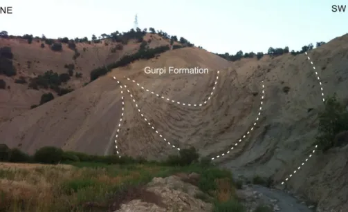
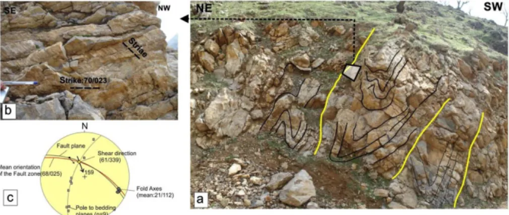
The High Zagros and Kermanshah faults are major reverse faults in the study area. The HZF, that is the southwestern boundary of the High Zagros zone, acted as a basin con-troller in subsidence of the Garau Formation during Early Cretaceous (refer to Sect. 3). In the KS area, the fault zone is well exposed with about 300 m in width in which several
5
drag folds and fault planes are mapped (Fig. 7). Most of the folds in the HZF zone are inclined folds plunging toward southeast and show the oblique kinematics of the fault with notable strike-slip component (Fig. 7).
The Kermanshah Fault as the other major fault of the KS area emplaces the Radio-larite basin material over the Arabian platform (Figs. 1 and 2).
10
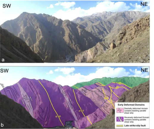
There are also early faults in the Radiolarite and Bisotoun zones (Fig. 8a). Using drag folds as kinematic indicators, the early faults in the Bisotoun zone and NE margin of the Radiolarite zone are dextral-reverse (Figs. 8a and 10) while in the central and SW parts of the Radiolarite zone, faults have both dextral-reverse and reverse mechanisms (Figs. 7 and 8a and their stereographic projections).
15
Folds
In the Radiolarite zone, mesoscopic scale folds are mapped within the alternation of medium to thick bedded radiolarite, pelagic limestone and shale (Figs. 8b and 9). Two types of deformed domains were identified in this zone. The reclined and inclined plung-ing folds developed by strike-slip kinematics and referred here as dextrally deformed
20
domains (Figs. 8b and 9). In the remaining parts of the Radiolarite zone, where hori-zontal inclined folds are dominant, they are kinematically inferred as reverse domains (Figs. 8b and 9). Narrow bedding parallel shear strips are also present in the Radiolar-ite zone, which contain plunging inclined folds (Fig. 11b) and reclined folds (Fig. 11a) in the dextrally deformed domains and horizontal inclined folds (Fig. 11c) in reversely
25
SED
7, 2735–2773, 2015Spatial evolution of Zagros collision zone
in Kurdistan
S. Sadeghi and A. Yassaghi
Title Page
Abstract Introduction
Conclusions References
Tables Figures
◭ ◮
◭ ◮
Back Close
Full Screen / Esc
Printer-friendly Version Interactive Discussion
Discussion
P
a
per
|
Discussion
P
a
per
|
Discussion
P
a
per
|
Discussion
P
a
per
|
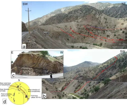
4.1.2 Late structures
The NW-trending Marekhil–Ravansar faults that are sub-parallel to the main trend of Zagros are two main strike-slip faults in the KS area (Fig. 6).
The Marekhil Fault offsets dextrally the early structures such as the Marekhil Anticline and Kermanshah Fault for about 32 km (Fig. 12). Towards southeast, the Marekhil Fault
5
joins to the HZF and caused reactivation of the fault in dextral manner. Similarly, the Ravansar Fault also offsets the early thrusts as well as the HZF early structures. Toward southeast, the Ravansar Fault strike-slip splays cut the HZF related folds and thrusts (Fig. 13) in which faults with old reverse-slip kinematics are reactivated by later dextral-slip movements (Fig. 13b).
10
Minor strike-slip faults in the restraining zone between the Marekhil and Ravansar faults also cut the early structures. There are outcrops where fault striations of both minor later strike-slip faults and older reverse faults are mapped (Fig. 14).
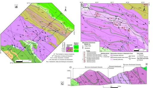
4.2 Structure of the Salas area
The Salas area that is located in the southwest of the HZF within the Folded Belt zone
15
is studied in detail to investigate the effect of Zagros oblique orogeny away from the collision zone (Figs. 2 and 15). Structures within this area comprise thrusts and related folds typical of the Folded Belt zone structures. Geometric and kinematic analysis of these structures (Fig. 15) showed that like the other part of the Zagros Folded Belt zone, thrust faults have no strike-slip component (e.g., Fars domain; Hessami et al.,
20
2001; McQuarrie, 2003). These structures cut by a series of transverse strike-slip faults (Figs. 1b and 15) consists of two major NNW-trending dextral-slip (Figs. 16a) and ENE-trending sinistral-slip faults (Figs. 16b) or normal faults with a component of sinistral-slip (Fig. 16c). There are also some locations where thrusts and folds cut by later strike-slip faults (Fig. 17b and f).
SED
7, 2735–2773, 2015Spatial evolution of Zagros collision zone
in Kurdistan
S. Sadeghi and A. Yassaghi
Title Page
Abstract Introduction
Conclusions References
Tables Figures
◭ ◮
◭ ◮
Back Close
Full Screen / Esc
Printer-friendly Version Interactive Discussion
Discussion
P
a
per
|
Discussion
P
a
per
|
Discussion
P
a
per
|
Discussion
P
a
per
|
4.3 Regional geological cross section
A regional cross section across the Zagros collision zone in NW Iran (Fig. 17) is drawn using direct field measurements and present stratigraphy data as well as assumptions in stratigraphy, time and depth of deformation as follows:
– The Phanerozoic sedimentary succession of Zagros comprises 7–12 km (Alavi,
5
2004) or up to 12 km (Colman-Sadd, 1978; Falcon, 1974a; James and Wynd, 1965; Stocklin, 1968) of sediments including Paleozoic, Mesozoic and Cenozoic strata. We considered the thickness of about 12 km (Fig. 3) for this succession in construction of the cross section (Fig. 17).
– Deformation in the Bisotoun (platform) and Radiolarite (basin) zones occurred
10
as thin skinned tectonic during the Late Cretaceous (Kazmin et al., 1986). Thick skinned tectonic, thus, did not have any major effect on the overall deformation of these zones.
– After collision of the Arabian Plate with Central Iran, a thick viscous layer at the base of the sedimentary cover (Hormoz salt) (McQuarrie, 2004) or its equivalents
15
(Sherkati and Letouzey, 2004) as a basal décollement zone decouple basement from the cover during the deformation. The Mountain Front Fault is considered as the SE boundary of the Hormoz salt or its equivalent shale basins (McQuarrie, 2004) (Fig. 17).
– Timing on involvement of the basement in the deformation is not clear but
as-20
sumed to occur in the last stage of deformation (Cenozoic) (e.g., Molinaro et al., 2005; Casciello et al., 2009; Mouthereau et al., 2007).
– Restoration of the cross section has been carried out using the line-length bal-ancing technique for all formations except Hormoz salt and Radiolarite zone sed-iments where area-balancing technique used (Fig. 17b). The total shortening of
25
SED
7, 2735–2773, 2015Spatial evolution of Zagros collision zone
in Kurdistan
S. Sadeghi and A. Yassaghi
Title Page
Abstract Introduction
Conclusions References
Tables Figures
◭ ◮
◭ ◮
Back Close
Full Screen / Esc
Printer-friendly Version Interactive Discussion
Discussion
P
a
per
|
Discussion
P
a
per
|
Discussion
P
a
per
|
Discussion
P
a
per
|
in Fig. 17). This shortening amount can be divided into 13 km for the sedimen-tary cover of both High Zagros and Folded Belt zones and remaining 49 km for the Bisotoun and Radiolarite zones (distance between L2 and L’2 in Fig. 17). The 13 km of shortening in sedimentary cover is equal to the initial length of cross section (distance between P and L2 in Fig. 17). The same amount of shortening
5
(16.5 %) is also obtained for the Folded Belt zone (distance between L1 and L’1 in Fig. 17).
5 Discussion
The proposed pre-convergence paleogeography of Zagros in Turonian (Late Creta-ceous) time shows that the northeastern margin of the Arabian platform was fully
10
extended and the Radiolarite basin and Bisotoun platform were developed (Fig. 4). Development of the Radiolarite basin constrain by synchronized thickening of the Ga-rau Formation in the High Zagros zone and sedimentation of thick sediments contains limestone and chert in the Radiolarite zone within the hanging wall of the High Zagros initially normal fault (Fig. 17b). The initial normal mechanism of the HZF (e.g., Jackson,
15
1980; Berberian, 1995) caused northward thickening of the sedimentary cover until the Late Cretaceous (e.g., Farzipour-Saein et al., 2009). This proposed paleogeography is similar to the ones presented by Kazmin et al. (1986), Fontaine et al. (1989) and Mo-hajjel et al. (2003). In Turonian–Campanian, the basin is inverted due to the obduction of Neotethys oceanic crust (Fig. 18a).
20
The obduction of Neotethys oceanic crust over the Bisotoun zone occurred in Maastrichtian–Paleocene along the so-called Main Zagros Thrust (Takin, 1972; Berbe-rian, 1995) (Fig. 18b). After the obduction, subduction of the oceanic crust resulted in development of the Gaveh Rud volcanic arc and Sanandaj–Sirjan metamorphic zone. This subduction was continuing until Early to Late-Miocene (McQuarrie et al., 2003;
25
meta-SED
7, 2735–2773, 2015Spatial evolution of Zagros collision zone
in Kurdistan
S. Sadeghi and A. Yassaghi
Title Page
Abstract Introduction
Conclusions References
Tables Figures
◭ ◮
◭ ◮
Back Close
Full Screen / Esc
Printer-friendly Version Interactive Discussion
Discussion
P
a
per
|
Discussion
P
a
per
|
Discussion
P
a
per
|
Discussion
P
a
per
|
morphic zone over the ophiolite zone (Fig. 18c). These major compressional events in the northeastern margin of the Arabian platform can be classified into the Late Creta-ceous oblique obduction related transpressional deformation and Cenozoic partitioning of oblique convergence described in more detail in the following sections.
5.1 Late Cretaceous oblique obduction related transpressional deformation
5
The early structures mapped in the Bisotoun and Radiolarite zones (Figs. 9–11) are considered as the result of the Neotethys oceanic crust obduction. This obduction that is considered to occur in Late Cretaceous (Kazmin et al., 1986; Agard et al., 2005; Wrobel-Daveau et al., 2010; Vergés et al., 2011; Karim et al., 2011) (Fig. 18a) is proposed to follow till Maastrichtian–Paleocene (Fig. 18b). About 49 km (79 %) of
10
shortening measured by restoration of the cross section is proposed to occur by the Late Cretaceous Oblique obduction (Fig. 17). In the Radiolarite zone, presence of dextrally deformed domains beside the reversely deformed domains (Fig. 9) implies the effect of Late Cretaceous transpression deformation related to oblique obduction (Fig. 18a and b). This demonstrates partitioning of the transpressional deformation to
15
dextrally deformed and reversely deformed domains. In addition, the presence of sev-eral dextral-reverse faults in the Bisotoun zone and NE of Radiolarite zones (Figs. 8 and 10) is in accordance with this oblique obduction. Similar type of deformation par-titioning was addressed for Silurian Caledonide orogeny in the sedimentary sequence consisting predominantly of turbiditic greywacke rocks by Jones et al. (2004).
20
5.2 Cenozoic partitioning of oblique convergence
The main stage of deformation in the Zagros orogeny was occurred by Cenozoic event (e.g., Falcon, 1976; Berberian and King, 1981). It is proposed that 13 km (16.5 %) of shortening measured by restoration of the regional cross section (Fig. 17) is occurred during the Cenozoic time. Despite contrasts on timing of the Cenozoic deformation, it is
25
SED
7, 2735–2773, 2015Spatial evolution of Zagros collision zone
in Kurdistan
S. Sadeghi and A. Yassaghi
Title Page
Abstract Introduction
Conclusions References
Tables Figures
◭ ◮
◭ ◮
Back Close
Full Screen / Esc
Printer-friendly Version Interactive Discussion
Discussion
P
a
per
|
Discussion
P
a
per
|
Discussion
P
a
per
|
Discussion
P
a
per
|
by the belt-parallel strike-slip faults (Talebian and Jackson, 2000; McQuarrie et al., 2003; Fakhari et al., 2009; Axen et al., 2010). The Marekhil–Ravansar fault system (Figs. 2 and 6) in the study area is evidence of such strike-slip faulting. These fault system laterally cut the early structures of dextrally deformed and reversely deformed domains as well as dextral-reverse faults (Figs. 8 and 9). These late strike-slip faults
5
in the Radiolarite and High Zagros zones imply that they are not confined to the Main Reverse Fault but distributed in outer parts of Zagros orogeny such as Radiolarite and High Zagros zones (Fig. 18c and d). The presences of the late strike-slip faulting are also documented by Gavillot et al. (2010) farther to the southeast part of High Zagros zone. Along the Marekhil Fault, as one of the main strike-slip faults in the study
10
area, around 32 km of strike-slip displacement is measured (Fig. 12). This shows that apart from the MRF, the Marekhil–Ravansar fault system is also accommodated a large amount of strike-slip deformation related to the Cenozoic oblique collision. The amount of 50 km of strike-slip displacement is proposed by Talebian and Jackson (2002) for the MRF activity. In the study area, however, this amount of displacement is proposed
15
as 10–15 km by Copley and Jackson (2006) and 16 km by Alipoor et al. (2012). We propose that 32 km out of 50 km of the MRF strike-slip displacement is more likely to be accommodated by the Marekhil–Ravansar fault system. Thus, we proposed that the total orogen-parallel strike-slip faulting in the study area is accommodated by both the Marekhil–Ravansar fault system as well as the MRF.
20
In the Salas area (within the Folded Belt zone), faults are generally pure thrust (Figs. 2, 15 and 16). These thrust faults, however, are laterally cut by strike-slip faults. Like the major transverse strike-slip faults in other parts of the Zagros Folded Belt zone (e.g., the Kazeroun Fault), these strike-slip faults likely have basement nature (e.g., Berberian, 1995; Hessami et al., 2001; Bahroudi and Koyi, 2003; Yassaghi, 2006) but
25
SED
7, 2735–2773, 2015Spatial evolution of Zagros collision zone
in Kurdistan
S. Sadeghi and A. Yassaghi
Title Page
Abstract Introduction
Conclusions References
Tables Figures
◭ ◮
◭ ◮
Back Close
Full Screen / Esc
Printer-friendly Version Interactive Discussion
Discussion
P
a
per
|
Discussion
P
a
per
|
Discussion
P
a
per
|
Discussion
P
a
per
|
5.3 Constrain for Arabia–Eurasia oblique convergence
There are two interpretations for inception time of the Zagros oblique convergence. The first interpretation proposes Pliocene (3–5 Ma) for initiation of the Zagros oblique con-vergence (e.g. Talebian and Jackson, 2002), while the second interpretation proposes the oblique collision at early to middle Miocene (19–15 Ma; Gavillot et al., 2010) or
ear-5
lier (Allen et al., 2004; Axen et al., 2010). The presented structural evidences in this paper constrain that the oblique convergence of the Arabia and Eurasia plates along the Zagros occurred since the late stage of orogeny in late Cretaceous–Paleocene. Similarly, these evidences might not support a possible scenario for drastic change in Arabia–Eurasia convergence from orthogonal to oblique manner (e.g. Navavabpour
10
et al., 2012; Mouthereau, 2011). Thus we propose that the Arabia–Eurrasia oblique convergence alongside Zagros occurred during all stages of Zagros orogeny since the Late Cretaceous.
6 Conclusions
The main outcomes of this study are summarized in the following points.
15
Extension of the Arabian platform in Early Cretaceous to form passive continental margins constrain by synchronized thickening of sedimentary rocks on the hanging wall of the High Zagros initial normal fault.
Presence of reversely and dextrally deformed domains within the Radiolarite zone are taken as a clue to conclude that oblique convergence related to the late Cretaceous
20
obduction event occurred in the early stage of the Zagros collision zone.
The Zagros oblique convergence is continued in Cenozoic by synchronously south-westward propagation of the Zagros orogeny via propagation of pure thrusts and re-lated folds (the Zagros Folded Belt zone) as well as overprinting of orogen-parallel strike-slip faulting on the late Cretaceous obduction related structures.
SED
7, 2735–2773, 2015Spatial evolution of Zagros collision zone
in Kurdistan
S. Sadeghi and A. Yassaghi
Title Page
Abstract Introduction
Conclusions References
Tables Figures
◭ ◮
◭ ◮
Back Close
Full Screen / Esc
Printer-friendly Version Interactive Discussion
Discussion
P
a
per
|
Discussion
P
a
per
|
Discussion
P
a
per
|
Discussion
P
a
per
|
Restoration of the regional cross section across the Zagros collision zone showed that large amount of shortening (79 %) occurred during the obduction. Propagation of the orogeny toward its more external part (i.e., the Zagros Folded Belt zone) caused 16.5 % of shortening.
Cenozoic strike-slip faulting is not confined to the Zagros suture zone (i.e., the Main
5
recent Fault), but distributed towards the more external parts of the orogeny (Marekhil– Ravansar fault system). Therefore, it is more likely that inception of these strike-slip faulting started from early to middle Miocene.
Presence of dextral transpressional deformation in Kurdestan area is used to pro-pose that oblique convergence of the Arabia–Eurasia plates affected during entire
his-10
tory of the Zagros orogeny (since the Late Cretaceous).
Acknowledgements. People of the Kurdistan province of Iran are acknowledged for their
sup-port during field works in the high Zagros Mountains near Iran and Iraq border with high risk of mine fields remained from 8 years of war.
References
15
Agard, P., Omrani, J., Jolivet, L., and Mouthereau, F.: Convergence history across Zagros (Iran): constraints from collisional and earlier deformation, Int. J. Earth Sci., 94, 401–419, 2005. Agard, P., Omrani, J., Jolivet, L., Whitechurch, H., Vrielynck, B., Spakman, W., Monié, P.,
Meyer, B., and Wortel, R.: Zagros orogeny: a subduction-dominated process, in: Geody-namic Evolution of the Zagros, edited by: Lacombe, O., Grasemann, B., and Simpson, G.,
20
Geological Magazine, Cambridge, UK, 692–725, 2011.
Alavi, M.: Regional Stratigraphy of the Zagros fold-thrust belt of Iran and its proforeland evolu-tion, Am. J. Sci., 304, 1–20, doi:10.2475/ajs.304.1.1, 2004.
Alavi, M.: Structures of the Zagros fold-thrust belt in Iran, Am. J. Sci., 307, 1064–1095, 2007. Ali, S., Mohajjel, M., Aswad, K., Ismail, S., Buckman, S., and Jones, B.: Tectono-stratigraphy
25
SED
7, 2735–2773, 2015Spatial evolution of Zagros collision zone
in Kurdistan
S. Sadeghi and A. Yassaghi
Title Page
Abstract Introduction
Conclusions References
Tables Figures
◭ ◮
◭ ◮
Back Close
Full Screen / Esc
Printer-friendly Version Interactive Discussion
Discussion
P
a
per
|
Discussion
P
a
per
|
Discussion
P
a
per
|
Discussion
P
a
per
|
Alipoor, R., Zaré, M., and Ghassemi, M. R.: Inception of activity and slip rate on the main recent fault of Zagros Mountains, Iran, Geomorphology, 175–176, 86–97, 2012.
Allen, M.: Roles of strike-slip faults during continental deformation: examples from the active Arabia–Eurasia collision, in: The Evolving Continents: Understanding Processes of Conti-nental Growth, Geological Society, London, UK, 329–344, 2010.
5
Allen, M., Jackson, J., and Walker, R.: Late Cenozoic reorganization of the Arabia–Eurasia collision and the comparison of short-term and long-term deformation rates, Tectonics, 23, TC2008, doi:10.1029/2003TC001530, 2004.
Authemayou, C. Chardon, D. Bellier, O. Malekzadeh, Z. Shabanian, E. and Abbassi, M. R.: Late Cenozoic partitioning of oblique plate convergence in the Zagros fold-and-thrust belt (Iran),
10
Tectonics, 25, TC3002, doi:10.1029/2005TCOO1860, 2006.
Axen, G., Fakhari, M., Guest, B., Gavillot, Y., Stockli, D. F., and Horton, B.: Distributed Oblique-dextral Transpression in the High Zagros Mountains, Iran, in: Tectonic Crossroads: Evolving Orogens of Eurasia-Africa-Arabia, Ankara, Turkey, Abstracts, 73 pp., 2010.
Azizi, H. and Jahangiri, A.: Cretaceous subduction-related volcanism in the northern Sanandaj–
15
Sirjan Zone, Iran, J. Geodyn., 45, 178–190, 2008.
Bahroudi, A.: The Effect of Mechanical Characteristics of Basal Décollement and Basement Structures on Deformation of the Zagros Basin, PhD Thesis, Uppsala University, Uppsala, Sweden, 43 pp., 2003.
Bahroudi, A. and Koyi, H. A.: Effect of spatial distribution of Hormuz salt on deformation style in
20
the Zagros fold and thrust belt: an analogue modelling approach, J. Geol. Soc. London, 160, 1–15, 2003.
Berberian, M.: Contribution to the Seismotectonics of Iran, Part II, Geological Survey of Iran, Tehran, Iran, 518 pp., 1976.
Berberian, M.: Master “blind” thrust faults hidden under the Zagros folds; active basement
tec-25
tonic and surface morphotectonics, Tectonophysics, 241, 193–224, 1995.
Berberian, M. and King, G. C. P.: Towards a paleogeography and tectonic evolution of Iran, Can. J. Earth Sci., 18, 210–265, 1981.
Beydoun, Z. R.: Arabian Plate Hydrocarbon, Geology and Potential – A plate Tectonic Ap-proach, American Association of Petroleum Geology, Studies In Geology, 33, 77 pp., 1991.
30
SED
7, 2735–2773, 2015Spatial evolution of Zagros collision zone
in Kurdistan
S. Sadeghi and A. Yassaghi
Title Page
Abstract Introduction
Conclusions References
Tables Figures
◭ ◮
◭ ◮
Back Close
Full Screen / Esc
Printer-friendly Version Interactive Discussion
Discussion
P
a
per
|
Discussion
P
a
per
|
Discussion
P
a
per
|
Discussion
P
a
per
|
Braud, J.: La suture du Zagros au niveau de Kermanshah (Kurdistan Iranien): reconstitution paléogéographique, évolution géodynamique, magmatique et structurale, PhD Thesis, Paris-Sud, Orsay, p. 488, 1987.
Casciello, E., Vergés, J., Saura, E., Casini, G., Fernandez, N., Blanc, E., Homke, S., and Hunt, D. W.: Fold patterns and multilayer rheology of the Lurestan Province, Zagros Simply
5
Folded Belt (Iran), J. Geol. Soc. London, 166, 947–959, doi:10.1144/0016-76492008-138, 2009.
Colman-Sadd, S.: Fold development in Zagros simply folded belt, Southwest Iran, AAPG Bull., 62, 984–1003, 1978.
Copley, A. and Jackson, J.: Active tectonics of the Turkish-Iranian Plateau, Tectonics, 25,
10
TC6006, doi:10.1029/2005TC001906, 2006.
Cotton, J. T. and Koyi, H. A.: Modelling of thrust fronts above ductile frictional de’collements: application to structures in the Salt Range and PotwPlateau, Pakistan, Geol. Soc. Am. Bull., 112, 351–363, 2000.
Fakhari, M. D., Axen, G. J., Horton, B. K., Hassanzadeh, J., and Amini, A.: Revised age of
15
proximal deposits in the Zagros foreland basin and implications for Cenozoic evolution of the High Zagros, Tectonophysics, 451, 170–185, 2008.
Falcon, N. L.: Southern Iran: Zagros Mountains, in: Mesozoic-Cenozoic Orogenic Belts, edited by: Spencer, A., Geological Society, London, Special Publications, London, UK, 4, 199–211, 1974.
20
Farzipour-Saein, A., Yassaghi, A., Sherkati, S., and Koyi, H.: Mechanical stratigraphy and fold-ing style of the Lurestan region in the Zagros Fold-Thrust Belt, Iran, J. Geol. Soc. London, 166, 1101–1115, doi:10.1144/0016-76492008-162, 2009.
Fontaine, J. M., Monod, O., Braud, J., and Perincek, D.: The Hezan Units: a fragment of south Neo-Theethyan passive continental margin in SE Turkey, J. Petrol. Geol., 12, 29–50, 1989.
25
Gavillot, Y., Axen, G. J., Stockli, D. F, Horton, B. K., and Fakhari, M. D.: Timing of thrust activity in the High Zagros fold-thrust belt, Iran, from (U/Th)/He thermochronometry, Tectonics, 29, TC4025, doi:10.1029/2009TC002484, 2010, 2010.
Gharib, F. and De Wever, P.: Mesozoic radiolarians from the Kermanshah formation (Iran), C. R. Palevol, 9, 209–219, 2010.
30
SED
7, 2735–2773, 2015Spatial evolution of Zagros collision zone
in Kurdistan
S. Sadeghi and A. Yassaghi
Title Page
Abstract Introduction
Conclusions References
Tables Figures
◭ ◮
◭ ◮
Back Close
Full Screen / Esc
Printer-friendly Version Interactive Discussion
Discussion
P
a
per
|
Discussion
P
a
per
|
Discussion
P
a
per
|
Discussion
P
a
per
|
Harrison, P. M., Frost. S. H., Seiglie, G. A., and Scheneidermann, N.: Regional unconformities and depositional cycles, cretaceous of the Arabian Peninsula, AAPG Memoir., 36, 67–80, 1984.
Hatzfeld, D. and Molnar, P.: Comparisons of the kinematics and deep structures of the Zagros and Himalaya and of the Iranian and Tibetan plateaus and geodynamic implications, Rev.
5
Geophys., 48, RG2005, doi:10.1029/2009RG000304, 2010.
Hessami, K. Koyi, H. A., Talbot, C. J., Tabasi, H., and Habanian, E. S.: Progressive unconformi-ties within an evolving foreland fold-and-thrust belt, Zagros Mountains, J. Geol. Soc. London, 158, 969–981, 2001.
Homke, S., Vergés, J., Serra-Kiel, J., Bernaola, G., Sharp, I., Garcés, M., Montero-Verdú, I.,
10
Karpuz, R., and Goodarzi, M. H.: Late Cretaceous–Paleocene formation of the proto-Zagros foreland basin, Lorestan Province, SW Iran, Geol. Soc. Am. Bull., 121, 963–978, 2009. Homke, S., Vergés, J., Van Der Beek, P., Fernàndez, M., Saura, E., Barbero, L., Badics, B.,
and Labrin, E.: Insights in the exhumation history of the NW Zagrosfrom bedrock and detrital apatite fission-track analysis: evidence for a long-lived orogeny, Basin Res., 22, 659–680,
15
2010.
Jackson, J. A.: Reactivation of basement faults and crustal shortening in orogenic belts, Nature, 283, 343–346, 1980.
James, G. A. and Wynd, J. G.: Stratigraphic nomenclature of Iranian oil consortium agreement area, AAPG Bull., 49, 2162–2245, 1965.
20
Jassim, S. Z. and Buday, T.: Tectonostratigraphy of the Zagros suture, in: Geology of Iraq, edited by: Jassim, S. Z. and Goff, C., Dolin, Prague and Moravian Museum, Brno, Czech Republic, 341 pp., 2006.
Jones, R. R., Holdsworth, R. E., Clegg, P., McCaffrey, K., and Tavarnelli, E.: Inclined transpres-sion, J. Struct. Geol., 26, 1531–1584, 2004.
25
Karim, K. H., Koyi, H., Baziany, M. M., and Hessami, K.: Significance of angular unconformities between Cretaceous and Tertiary strata in the northwestern segment of the Zagros fold– thrust belt, Kurdistan Region, NE Iraq, Geol. Mag., 148, 925–939, 2011.
Kazmin, V. G., Ricou, L. F., and Sbortshikov, I. M.: Structure and evolution of the passive margin of the eastern Tethys, Tectonophysics, 123, 153–179, 1986.
30
SED
7, 2735–2773, 2015Spatial evolution of Zagros collision zone
in Kurdistan
S. Sadeghi and A. Yassaghi
Title Page
Abstract Introduction
Conclusions References
Tables Figures
◭ ◮
◭ ◮
Back Close
Full Screen / Esc
Printer-friendly Version Interactive Discussion
Discussion
P
a
per
|
Discussion
P
a
per
|
Discussion
P
a
per
|
Discussion
P
a
per
|
McClusky, S., Balassanian, S., Barka , A., Demir, C., Ergintav, S., Georgiev, I., Gurkan, O., Hamburger, M., Hurst, K., Kahle, H., Kastens, K., Kekelidze, G., King, R., Kotzev, V., Lenk, O., Mahmoud, S., Mishin, A., Nadariya, M., Ouzoums, A., Paradissis, Y. P., Prilepin, M., Reilinger, R., Sanli, I., Seeger, H., Tealeb, A., Toksoz, M. N., and Veis, G.: Global Positioning System constraints on plate kinematics and dynamics in the eastern Mediterranean and
5
Caucasus, J. Geophys. Res., 105, 5695–5719, 2000.
McQuarrie, N.: Crustal scale geometry of the Zagros fold-thrust belt, Iran, J. Struct. Geol., 26, 519–535, 2004.
McQuarrie, N., Stock, J. M., Verdel, C., and Wernicke, B. P.: Cenozoic evolution of neotethys and implications for the causes of plate motions, Geophys. Res. Lett., 30, 2036,
10
doi:10.1029/2003GL017992, 2003.
Mohajjel, M. and Fergusson, C. L.: Dextral transpression in Late Cretaceous continental colli-sion, Sanandaj-Sirjan Zone, western Iran, J. Struct. Geol., 22, 1125–1139, 2000.
Mohajjel, M. and Fergusson, C. L.:: Jurassic to Cenozoic tectonics of the Zagros Orogen in northwestern Iran, Int. Geol. Rev., 56, 263–287, doi:10.1080/00206814.2013.853919, 2013.
15
Mohajjel, M., Fergusson, C. L., and Sahandi, M. R.: Cretaceous-Tertiary convergence and continental collision, Sanandaj-Sirjan Zone, western Iran, J. Asian Earth Sci., 21, 397–412, 2003.
Molinaro, M., Leturmy, P., Guezou, J.-C., and Frizon de Lamotte, D.: The structure and kine-matics of the south-eastern Zagros fold-thrust belt; Iran: from thin-skinned to thick-skinned
20
tectonics, Tectonics, 24, TC3007, doi:10.1029/2004TC001633, 2005.
Motiei, H.: Stratigraphy of Zagros, Treaties on the Geology of Iran, Geol. Survey of Iran Publi-cation, Tehran, Iran, 536 pp., 1993 (in Persian).
Mouthereau, F., Tensi, J., Bellahsen, N., Lacombe, O., De Boisgrollier, T., and Kargar, S.: Tertiary sequence of deformation in a thin-skinned/thick-skinned collision belt: the Zagros
25
Folded Belt (Fars, Iran), Tectonics, 26, TC5006, doi:10.1029/2007TC002098, 2007.
Mouthereau, F., Lacombe, O., and Vergés, J.: Building the Zagros collisional orogen: timing, strain distribution and the dynamics of Arabia/Eurasia plate convergence, Tectonophysics, 532–535, 27–60, 2012.
Navabpour, P. and Barrier, E.: Stress states in the Zagros fold-and-thrust belt
30
SED
7, 2735–2773, 2015Spatial evolution of Zagros collision zone
in Kurdistan
S. Sadeghi and A. Yassaghi
Title Page
Abstract Introduction
Conclusions References
Tables Figures
◭ ◮
◭ ◮
Back Close
Full Screen / Esc
Printer-friendly Version Interactive Discussion
Discussion
P
a
per
|
Discussion
P
a
per
|
Discussion
P
a
per
|
Discussion
P
a
per
|
Nemati, M. and Yassaghi, A.: Structural characteristics of the transitional zone from internal to external parts of the Zagros orogen, Iran, J. Asian Earth Sci., 39, 161–172, 2010.
Ricou, L. E., Braud, J., and Brunn, J. H.: Le Zagros, Société Géologique de France, Mémoire Hors Série, 8, 33–52, 1977.
Sarkarinejad, K.: Quantitative finite strain and kinematic flow analyses along the Zagros
trans-5
pression zone, Iran, Tectonophysics, 442, 49–65, 2007.
Sarkarinejad, K. and Azizi, A.: Slip partitioning and inclined dextral transpression along the Zagros Thrust System, Iran, J. Struct. Geol., 30, 116–136, 2008.
Searle, M. P. and Graham, G. M.: “Oman Exotics” – oceanic carbonate build-ups associated with the early stages of continental rifting, Geology, 10, 43–49, 1982.
10
Sherkati, S., Letouzey, J., and Frizon de Lamotte, D.: Central Zagros fold-thrust belt (Iran): new insights from seismic data, field observation, and sandbox modeling, Tectonics, 25, TC4007, doi:10.1029/2004TC001766, 2006.
Stocklin, J.: Structural history and tectonics of Iran; a review, AAPG Bull., 52, 1229–1258, 1968. Talbot, C. J. and Alavi, M.: The past of a future syntaxisacross the Zagros, in: Salt Tectonics,
15
edited by: Alsop, G. I., Blundell, D. J., and Davison, I., Geological Society of London, London, UK, Special Publication no. 100, 89–109, 1996.
Talebian, M. and Jackson, J.: Offset on the main recent fault of NW Iran and implicationson the late Cenozoic tectonics of the Arabia–Eurasia collision zone, Geophys. J. Int., 150, 422–439, 2002.
20
Tatar, M., D., Hatzfeld, J., Martinod, A., Walpersdorf, M., Ghafori-Ashtiany, and Chéry, J.: The present-day deformation of the central Zagros from GPS measurements, Geophys. Res. Lett., 29, 1927, doi:10.1029/2002GL015427, 2002.
Vergés, J., Saura, E., Casciello, E., Fernàndez, M., Villaseñor, A., Jiménez-Munt, I., and Gar-cíaCastellanos, D.: Crustal-scale cross-section across the NW Zagros Belt: implications for
25
the Arabian Margin reconstruction, in: Geodynamic Evolution of the Zagros, edited by: La-combe, O., Grasemann, B., and Simpson, G., Geological Magazine, Cambridge, UK, 148, 739–761, 2011.
Vernant, P., Nilforoushan, F., Hatzfeld, D., Abassi, M., Vigny, C., Masson, F., Nankali, H., Mar-tinod, J., Ashtiani, A., Bayer, R., Tavakoli, F., and Chery, J.: Contemporary crustal deformation
30
SED
7, 2735–2773, 2015Spatial evolution of Zagros collision zone
in Kurdistan
S. Sadeghi and A. Yassaghi
Title Page
Abstract Introduction
Conclusions References
Tables Figures
◭ ◮
◭ ◮
Back Close
Full Screen / Esc
Printer-friendly Version Interactive Discussion
Discussion
P
a
per
|
Discussion
P
a
per
|
Discussion
P
a
per
|
Discussion
P
a
per
|
Figure 7. (a, b)The High Zagros Fault Zone;(c)close view of the drag folds with line drawing;
SED
7, 2735–2773, 2015Spatial evolution of Zagros collision zone
in Kurdistan
S. Sadeghi and A. Yassaghi
Title Page
Abstract Introduction
Conclusions References
Tables Figures
◭ ◮
◭ ◮
Back Close
Full Screen / Esc
Printer-friendly Version Interactive Discussion
Discussion
P
a
per
|
Discussion
P
a
per
|
Discussion
P
a
per
|
Discussion
P
a
per
|
Figure 11.Bedding parallel shear strips in the Radiolarite zone and their kinematic interpreta-tion using stereographic projecinterpreta-tion as:(a)bedding parallel shear strips with recline folds;(b)
SED
7, 2735–2773, 2015Spatial evolution of Zagros collision zone
in Kurdistan
S. Sadeghi and A. Yassaghi
Title Page
Abstract Introduction
Conclusions References
Tables Figures
◭ ◮
◭ ◮
Back Close
Full Screen / Esc
Printer-friendly Version Interactive Discussion
Discussion
P
a
per
|
Discussion
P
a
per
|
Discussion
P
a
per
|
Discussion
P
a
per
|
Figure 13. (a)Overall view of the outcrop and line drawing of horizontally inclined folds in the pelagic limestone of Ilam Formation in the High Zagros Fault footwall cut by younger strike-slip faults; (b) stereographic projection show interpreted movement direction of fault zone (black arrow) based on attitudes of folds axes;(c) fault with 1st generation (St.1) reverse and 2nd generation (St.2) dextral-reverse slickenlines;(d, e)dextral faults with reverse component;(f)
SED
7, 2735–2773, 2015Spatial evolution of Zagros collision zone
in Kurdistan
S. Sadeghi and A. Yassaghi
Title Page
Abstract Introduction
Conclusions References
Tables Figures
◭ ◮
◭ ◮
Back Close
Full Screen / Esc
Printer-friendly Version Interactive Discussion
Discussion
P
a
per
|
Discussion
P
a
per
|
Discussion
P
a
per
|
Discussion
P
a
per
|
Figure 17. (a) Regional cross section across the Zagros orogeny in NW Iran (see line A–E in Fig. 2 for the section location and descriptions of its lithological and lithostratigraphic units);
SED
7, 2735–2773, 2015Spatial evolution of Zagros collision zone
in Kurdistan
S. Sadeghi and A. Yassaghi
Title Page
Abstract Introduction
Conclusions References
Tables Figures
◭ ◮
◭ ◮
Back Close
Full Screen / Esc
Printer-friendly Version Interactive Discussion
Discussion
P
a
per
|
Discussion
P
a
per
|
Discussion
P
a
per
|
Discussion
P
a
per
|
Figure 18.Possible scenario for the Zagros oblique convergence history since the Late Cre-taceous.(a)The initial stage of the convergence by obduction of the Neotethys oceanic crust;