Automated Generation of Indoor Accessibility Information
for Mobility-Impaired Individuals
Nemanja Kosti´c
Institute for Geoinformatics, University of M¨unster
Abstract. One section of the general population that can greatly benefit from the current interest in indoor navigation systems comprises the various disabled groups. In developing assistive navigation systems an important issue is how to obtain information relevant for nav-igation from the perspective of these special user groups. The theory of affordances coupled with computer-based simulation offers a solution for automated extraction of this information from readily available sources - architectural floor plans. Simulation of movement in space can be used to derive a user-relative selection of accessible space by comparing the degree of match between the geometrical demands of navigation and the relevant physical properties of the environment. We also investigate what is the right level of representation of the envi-ronment for running the simulations as well as deriving higher-level networks of places and their connections that facilitate orientation and the interaction between user and navigation system.
1 Introduction and Motivation
Various kinds of disability - motor, visual, auditory, cognitive - affect the ease and safety of navigation in space. The spatial decision-making process of disabled groups can be facil-itated by building assistive navigation systems that offer access to environmental informa-tion that would otherwise either be out of reach or acquirable at the expense of much effort and frustration. Historically, such navigation systems have overwhelmingly dealt with out-door environments since precise localisation techniques (such as GPS) were only available outside. However, recent developments in sensor-based positioning and ubiquitous comput-ing have extended these efforts indoors [1]. Indoor spaces pose their own unique obstacles for attempts to develop a successful navigation aid; one such challenge is the availability of navigationally relevant information, especially for architecturally complex public buildings. To begin with, we can ask what kind of environmental information an assistive naviga-tion system should provide. The type of disability plays a crucial role in determining where and how navigation can be helped; focusing on an example scenario of a wheelchair user planning and executing a visit to a large public building, the most critical piece of infor-mation concerns accessibility: whether the space allows the user to move between indoor locations of interest, and if so, what are the optimal ways to do so.
In case of the relevant information not being readily available, how can we obtain it in an exhaustive, reliable and relatively simple way? A common way to assess the accessibility of an environment is to perform a survey while making note of potential obstacles for movement (presence of stairs/ramps, ramp slopes, etc.). This raw data can be compared
to established criteria for accessibility assessment (such as legally defined guidelines for the design of public buildings; see for example [15]); in this way, accessibility is determined in situ and later entered as annotation into a computer model of the environment for use in navigation systems or further analyses. The process is relatively easy to perform (though not always to manage), but also time-consuming and prone to different types of uncertainty: it cannot guarantee exhaustiveness and is often dependent on subjective assessment.
Automatisation of accessibility assessment has been suggested in research on public transportation planning [12, 13] and ergonomics in the workplace [6]; how to go about this task in the context of assistive indoor navigation systems is the focus of this paper. We propose a method to compute a user-relative selection of accessible space as well as a set of accessible paths between indoor places. We also discuss the right level of representation of the indoor environment to serve as input for the computation by preserving in detail geometrical properties of the environment while at the same time allowing straightforward extraction of a network of accessible places and their connecting paths.
The next section presents previous work related to our goal, before we turn to the specifics of the proposed methodology of accessibility information extraction, a use case of a real-world indoor environment and finally a discussion of open questions and possible ways of integrating the resulting information into different types of navigation systems.
2 Discussion of Related Work
2.1 Affordances
The kind of disability determines its distinctive effects on navigation in space. One valuable attempt to theoretically model this interdependency of individuals’ capabilities and the environment they act in has been made in ecological psychology. Gibson introduced the idea of affordances as opportunities for action offered by the environment: different objects or their constellations are suitable through their properties for different types of use, and humans and other animals can perceive and act on these opportunities [9]. In this way, the environment takes on meaning, in the sense that it carries information that can guide behaviour [19]. That there is an interdependency between these action potentialities and the acting entities means that affordances are what they are only for specific kinds of animals. A person in a wheelchair, for example, faced with a flight of stairs, ”perceives obstacles where other people just perceive a step they can climb” [16]. For any customised information system, modelling the environment in terms of affordances offers ”an experiential view of space, because they offer a user-centered perspective” [17].
2.2 Situated Simulation
What determines the existence of an affordance? The agent-environment complementarity that the notion of affordance models means that an affordance can be assigned to an object only when a potential action exists that includes the object [19]. Recent developments in
cognitive science hint in the direction of action-dependent meaning as well. Barsalou refers to ad-hoc grouping of environmental objects based on their usefulness for the action being planned or executed; in this way dynamic categories arise, such as ’things to stand on’ when planning to replace a lightbulb on the ceiling. This judgement of usefulness of an object depends on the mental simulation of the action on the object and its success (or lack thereof) and relies on object concepts encoding the objects’ affordances: concepts are toolboxes for action [3, 4]. Building on this, Scheider proposed to ground affordances as perceivable potential events - successful simulations of actions generated while processing environmental input [20].
Experiments have shown that not only are people very good at correctly judging objects in this way, but that this process can be quantified. Warren’s trials resulted in a ratio value between a subject’s leg length and the riser height of a flight of stairs as the determinant of the existence of the climbability affordance in the subject’s perception - when this ratio exceeded 0.88 the stairs were clearly assessed as unclimbable [22]. Except for simple cases, however, body scales are not enough to solely explain the existence of affordances, because they fail to fully describe what one can do - one’s ability, or functional properties [7]. A paralysed individual’s leg length can be the same as that of an able-bodied person but the environment’s climbability affordances are drastically different for them.
Two main insights of the work on the emergence of affordances are relevant for our goal. Firstly, treating affordances as agent-action-environment relations means that a record of properties of an environment cannot be equated with a description of its affordances - these emerge only when concrete actors and actions enter into the equation. Furthermore, the set of affordances of an environment can be derived by situated simulation of action, where situatedness refers to its grounding in concrete agent-side constraints and simulation to the possibility of assessing affordances independently of the action being actually performed.
2.3 Automated Mobility Affordance Assessment
The idea of automating the task of deriving information meaningful for navigation appears in [13]; it is further elaborated in [12]. The authors propose a computer-based ”translation of selected environmental attributes [of public park paths] into a scaled suitability value for individual mobility” as an alternative to subjective or rule-of-thumb affordance assess-ment. Suitability here refers to the extension of the concept of affordance beyond simple (im)possibility of action to include different levels to which an action can be afforded by an object. For example, a ramp may allow movement to many people but demand different amounts of effort from each of them, which may significantly influence their spatial decision making.
In a related application area, computer simulation was suggested in [5] to assess the ergonomic quality of workplaces using 3D virtual reality techniques. A wheelchair user was modelled based on statistical data on maximal arm reach to identify zones out of reach of the user in order to assess the need for a rearrangement of the work environment.
A similar goal drove the development of the HADRIAN database and SAMMIE simula-tion environment; these encompass not only the specific needs of disabled individuals but also the effects of age and/or difference in body scales, thereby allowing increasingly fine adjustments to individual needs [23].
The Environment When assessing mobility affordances we must ask what features in the environment enable or impede movement; in the case of automation, the question refers to the choice of an adequate input spatial model for the procedure, since this restricts the amount and type of environmental information to be analysed. [12, 13] use a network model - paths as edges and intersections as nodes - with relevant environmental properties (such as length or slope) as well as the resulting suitability values aggregated on path level.
In the case of clearly delineated path in a park it is justified to assign affordances to it. However, in indoor environments such as halls or rooms there are not always obvious paths: such spaces appear not to be discretised into networks but rather exhibit continuity and are better described as scenes [18]. As noted in [21], we should bear in mind that unlike vehicles, pedestrians are not constrained to linear routes: to exhaustively model indoor movement using a network we should identify all possible paths between all possible pairs of destinations, leading to huge networks even for moderately complex indoor environments. It is clear then that aggregating environmental properties into discrete objects is not an optimal solution for indoor accessibility assessment. If one can move between two locations in a room, which of the many possible paths between them is the affordance bearer? Selecting one of them arbitrarily would imply unjustified ’gerrymandering’ (to borrow a phrase from Lewis as quoted in [19]), whereas modelling each one explicitly is very difficult. In indoor environments, mobility affordances are better thought of as attributes of the continuous space itself, and only after accessibility has been determined on the level of continuous geometry of obstacles and free space can we start breaking down the environment into destinations (in one way or another; this is quite arbitrary below the level of obvious architectural units such as rooms or corridors). For accessibility analysis, therefore, an input spatial model preserving the continuity of space is called for.
The Agent The other side of the affordance relation comprises agent-side properties; which among these hold relevance for an assessment procedure depends on the action in question. As we have seen, body scales are just a stand-in for what one can effectively do, and not always a good one at that; is there another way to encode ability? The procedure presented in [12, 13] builds on the idea of affordances as ratio values as outlined in section 2.2: different levels of various factors of motor ability are expressed as scaled values to be compared to the corresponding physical properties of the environment.
Another way to look at motor ability representation is hinted at in [1]. The authors’ proposal of a spatial model for indoor navigation consists of three levels: spatial, feature and action. Whereas the spatial level captures continuous geometric information on in-door environments, the feature level explicitly models objects (mobile and static). One
important set of attributes of an object are its interaction spaces: properties modelling the objects’ physical extent or spaces needed for them to perform their expected actions (”operational space”). The intention here is to semantically enrich the spatial layer with meanings of spaces as they relate to different types of objects. However, we can use the idea of attributing action-relative spatial extents to users for our purpose: spatial analysis for affordance derivation.
2.4 Types of Information for Indoor Navigation Systems
Basic functions of indoor navigation systems comprise user localisation, path planning, directions derivation and provision of information on the objects in the user’s surroundings [8]. These services rely on two broad categories of spatial knowledge encoded in navigation systems: geometric and semantic, where the former models space as a collection of points with numeric coordinates while the latter decomposes space into chunks to which human-readable descriptions are attached (e.g. ”You are in the entrance hall.”), making it better suited to user-system interaction [2].
Looking back at our hypothetical scenario, what is sought is information on the extent to which the building’s space offers basic mobility to the user, while asking for answers in terms of the building’s semantics (e.g. ”Can I - and what is the easiest way to - get from the entrance hall to room 3?”). This twofold perspective on environments - space vs. place, geometry vs. semantics (also: continuity vs. topology [14]) - is an integral part of accessibility assessment when its final goal is its use in navigation systems. The input model for our procedure has to enable the derivation within the accessible space of a structure of places as well as their optimal connections, for which network-based analyses are necessary. Following the discussion in section 2.3, it appears that there are conflicting demands from the model: it should be both non-network and network. A model that stores environmental properties in a way that fits both descriptions is discussed in section 3.2.
3 Discussion of Methodology
In this section we discuss a methodology to automatically extract accessibility information on indoor environments for use in assistive navigation systems, focusing on the case of wheelchair users. We start with a widespread and readily available information source on indoor spaces - architectural floor plans in CAD format - as a sufficient record of environ-mental properties for accessibility computation. Integrating the insights presented in [12, 13], [5] and [1], we propose to derive mobility affordances for a wheelchair user by simu-lating movement in space. This is done by matching the geometrical constraints of actions involved in moving in a wheelchair with the geometry of obstacles in the environment. Based on assessment at the level of environmental geometry we can derive a set of optimal paths between places in the indoor environment. The way we conceptualise agents, their movement and the environment is explained in the following subsections, before we outline the procedure itself.
3.1 Modelling the Agent and Action
We propose an algorithm for mobility affordance derivation that performs an exhaustive analysis of space for the possibility of movement. To do this, we conceptualise continuous path taking in space as a set of a set of discrete moments; at each moment the agent occupies a particular location and performs what we term a movement primitive: a person either simply fits into the space, only to move at the next moment to the adjacent location in the same direction, or performs a turn to change direction. To derive mobility affordances for an environment, we test whether each location within it affords movement itself by testing whether the moving primitives are afforded.
At each location, then, we test two conditions: first, with the agent’s centroid at the location, whether the surrounding space allows fit; second, whether it affords unobstructed spinning so that turns can be made. The two tests rely on three agent-relative movement constraints: the geometries of fit (in the x− and y−direction) and spinning, with the latter implying the other two. These geometrical constraints depend both on body scales as well as any additional equipment necessary for movement, such as a wheelchair or walking stick. They have been extensively studied and have entered national guidelines for the design of indoor spaces: German DIN 18024-1 standard ([24]) provides useful quantifications (Fig. 1a, b).
If both conditions hold, we say that the location affords full possibility of movement; if only the former is true, the location is a potential point on a path but affords no turns - movement can only proceed straight ahead in the x− or y−direction (provided that the adjacent location itself allows at least fit). What we obtain in this way is a network of locations with turn restrictions, suitable for routing; we term the set of all such locations occupiable space and the corresponding network accessibility graph.
The effect of running the tests at each location is similar to running vast numbers of agent-based simulations between pairs of locations, requiring however less time, generating no noise and, most importantly, providing exhaustiveness. It models the possibility of movement in the simulated space without reference to any individual paths: unlike agent-based simulations, mobility affordances do not emerge here as results of simulated path taking but as possibilities for it. Furthermore, continuous testing across space is in accord with the conclusion that mobility affordances are attributes of continuous space rather than of any one environmental object.
3.2 Modelling the Environment
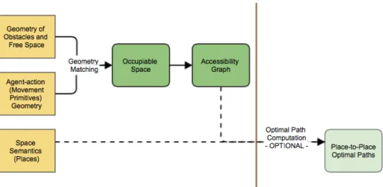
Referring to the discussion in section 2, there are conflicting demands on our input model: it should preserve the continuity of the indoor geometry yet either incorporate or enable the derivation of network-based structures of space and the running of network-based analyses. The various required conceptions of space as inputs and outputs for our analysis are shown in Fig. 2.
Fig. 1. a. Path taking can be thought of as a collection of discrete moments tn; b. Movement primitives
geometry: x-direction fit (green), y-direction fit (blue) and spinning (violet; based on DIN 18024-1); within this layout of obstacles (grey), only x-direction fit is afforded
Our search for an adequate spatial model is guided by the comparative review presented in [2], as well as the procedure outlined in section 3.1. The geometry of obstacles is captured with precision in a CAD model; however, its lack of the explicit encoding of empty space prevents easy action-environment geometry match necessary to derive occupiable space. Moreover, standard network-based analyses such as optimal paths computation cannot be run on CAD models. The issue of continuous coverage of space can be resolved by using cell-based models (tessellations); additionally, these implicitly model spatial adjacency. This is crucial in our case: to establish the possibility of movement between locations in space by only testing the locations themselves for mobility affordances, we must ensure that locations - cells - adjacent in the model represent locations adjacent in reality.
We decided that a regular tessellation (grid) lends itself best to our method. While irregular cells in general capture the geometry of obstacles with more precision, they also have an important drawback from the perspective of our goal. To test locations (cells) for movement affordances as described above, at each cell a neighbourhood of i ∗ j surrounding cells models the agent-relative geometry of fitting in space and spinning. Easy automation of the testing procedure asks for a uniform cell size across the modelled space so that these action geometries can be consistently compared against the environmental geometry.
To allow routing on the occupiable space, we propose to use the idea of the grid graph as outlined in [14]. The grid graph model starts from a regular tessellation of the environment and then builds a base graph on top of it by treating each cell as a network node and
Fig. 2. Spaces as input (yellow) and output (green) of accessibility analysis
connections between the cell and adjacent cells as edges to which weights are attached. In this way it offers the analytical advantages of network representations while retaining the continuity of spatial geometry. Another welcome feature of the grid graph model is that it stores the space semantics by labeling each node with membership in a named architectural unit (place); the structure of places is modeller-specified. In this way place-based graphs of various levels of abstraction can be derived from the base graph.
Modelling the geometry of obstacles to movement requires a working definition of ob-stacle. These usually refer to architectural barriers - walls and ceilings - but an advantage of a continuous spatial representation is that fixtures and furniture too can be explicitly modelled. In this way a very precise selection of accessible space can be computed: taking as an example our use case of a public library, stack areas can be tested and fine routing performed on the resulting occupiable space.
Our procedure as outlined below is constrained to two-dimensional space. The algorithm does not check for differences in the height coordinates of cells and the restrictions to movement in a wheelchair that this can cause. For this reason, stair and ramp areas are treated as obstacles from the outset, cells belonging to these areas being excluded from occupiable space computation.
To settle the issue of optimal grid resolution, we performed a comparative analysis of three different resolutions in our use case (section 4) and compared them to the CAD source to determine how the difference affects the resulting occupiable space computation. This calibration of grid resolution would have to be performed for each environment being analysed.
3.3 Accessibility Assessment: Procedure
The outlined procedure was implemented in the TerraME modelling environment [6], with the conversion from CAD to tessellation done via the TerraView GIS. TerraME’s Cellu-larSpace class implements the grid graph idea by allowing explicit modelling of connection weights between adjacent grid cells so that network analyses can be run on it. The algorithm runs in linear time O(n) for all outlined steps.
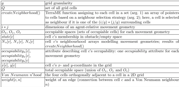
Table 1. Symbols Used in Pseudocode g grid granularity
Q set of all grid cells
createN eighborhood() TerraME function assigning to each cell in a set (arg. 1) an array of pointers to cells based on a neighbour selection strategy (arg. 2); here, a cell is selected as neighbour if it is one of the (i/g) ∗ (j/g) surrounding cells
i ∗ j dimensions of an agent-relative movement geometry
Ox, Oy, Os occupiable spaces (sets of occupiable cells) for each movement geometry
state[c] cell c’s membership in obstacle/empty space
Nx[c], Ny[c], Ns[c] cell c’s neighbourhood arrays modelling movement geometries; results of
createN eighborhood() occupiabilityx[c],
occupiabilityy[c],
occupiabilitys[c]
attribute describing cell c’s occupability: one occupiability attribute for each movement geometry
x[c], y[c] cell c’s x- and y-coordinate in the grid
O total occupiable space (union of Ox, Oyand Os)
V on N eumann n0hood the four cells orthogonally adjacent to a cell in a 2D grid
weight[c, n] weight of an edge (connection between cell c and a Von Neumann neighbour n)
0. Convert the CAD files into a grid with granularity g; g should be divisible without remainder into the dimensions of agent-relative movement geometries (fit and spin). Each cell belongs either to empty space or an obstacle; these membership values are stored in cells’ state attribute.
1. For each agent-relative movement geometry (x- and y- direction fit and spinning), assign the cells modelling it to each grid cell, for testing in step 2.
function assignMovementGeometriesToCells(Q) . for each cell, create three neighbourhoods . modelling the three movement geometries createN eighborhood(Q, (ix * jx)/g2) . x-fit: ix= 120 cm, jx= 75 cm
createN eighborhood(Q, (iy * jy)/g2) . y-fit: iy = 75 cm, jy= 120cm
createN eighborhood(Q, (is * js)/g2) . spinning: is = 150cm, jy= 150 cm
2. For each agent-relative movement geometry, compute the respective occupiable space. For each cell, test whether all the assigned cells modelling the movement geometry belong
to empty space; if so, the cell is labelled occupiable and added to the occupiable space. The pseudocode below shows the computation for x-direction fit; the procedure is identical for the other two movement geometries.
function getOccupiableSpaceXDir(Q) initialise Oxas empty set
for each cell c in Q do
if state[c] = EM P T Y then for each cell n ∈ Nx[c] do
if state[n] = EM P T Y then count ← count + 1
if count = size(Nx[c]) then . size(N [c]) = (i ∗ j)/g2
occupiabilityx[c] ← OCCU P IABLE
add c to Ox
return Ox
3. Construct the accessibility graph on the total occupiable space by instantiating con-nections (edges) between occupiable cells (nodes). Each occupiable cell is connected to those of its orthogonally adjacent cells (comprising the cell’s Von Neumann neighbourhood) to-wards which movement is afforded; the existence of a connection depends on the types of occupiability of both current and adjacent cell as well as the adjacent cell’s location relative to the current cell. For example, based on the limitations of moving in a wheelchair, if an agent can fit in a cell in the x-direction only (no spinning afforded), it can only proceed in a straight path - that is, to the adjacent cells with the same y-coordinate, and only so if they allow (at least) fit in the x-direction as well. Since movement was modelled for the x- and y-directions only, diagonally adjacent cells are not considered when constructing the graph; the encoded turns are therefore 90-degree. Each possible connection is assigned a weight equalling grid granularity g; impossible connections carry very high weights to avoid routing through them.
4 Case Study: ULB
As a test case, we dealt with the university and state library (Universit¨ats- und Landes-bibliothek, ULB) in M¨unster. In this chapter we shortly discuss the results.
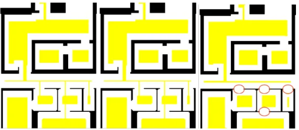
A preliminary occupiable space computation for a section of the ULB was performed on grids with granularity 5, 7.5 and 10 cm respectively (Fig. 3). Comparison to the CAD source revealed that while there was virtually no difference between the former two in correctly identifying overall accessibility, the latter rendered some accessible door spaces inaccessible: the coarser resolution meant that some empty space was lost in the CAD-grid conversion by being assigned to cells mostly comprised of obstacle space. Only a few centimeters lost, however, means that the constraints of action (passing through) are no
function constructAccessibilityGraph(O) for each cell c in O do
if occupiabilitys[c] = OCCU P IABLE then . spinning at c possible
for each Von Neumann neighbour n of c do
if (x[n] = x[c] and ocupiabilityy[n] = OCCU P IABLE) or (y[n] = y[c] and ocupiabilityx[n]
= OCCU P IABLE) then
weight[c, n] ← g . weight is equal to grid granularity else
weight[c, n] ← inf inity . any very large value else if occupiabilityx[c] = OCCU P IABLE then . fit in the x-direction at c possible
for each Von Neumann neighbour n of c do
if y[n] = y[c] and occupiabilityx[n] = OCCU P IABLE then
weight[c, n] ← g else
weight[c, n] ← inf inity
else if occupiabilityy[c] = OCCU P IABLE then . fit in the y-direction at c possible
for each Von Neumann neighbour n of c do
if x[n] = x[c] and occupiabilityy[n] = OCCU P IABLE then
weight[c, n] ← g else
weight[c, n] ← inf inity
longer satisfied. For reasons of computational performance, resolution of 7.5 cm was chosen for the subsequent analysis.
Fig. 4 shows the different ways in which locations (cells) can afford mobility. An agent can simply fit into the space (in the x- or y-direction) or the full possibility of turning can be afforded. All three subsets of the overall space are needed to model movement and routing algorithms have to take into account the turn restrictions. Fig. 5 shows a shortest path computed using a Dijkstra algorithm that implements these restrictions. Turns can only occur at cells that have come out from the occupiable space computation as allowing turns.
5 Conclusion
Limitations of the Method and Possible Improvements The procedure is restricted to two-dimensional space; to fully assess the accessibility of an indoor environment an extension into the third dimension is needed. Movement of wheelchair users can be impeded by features such as door handles or elevator buttons that are out of reach. 3D extension would also make it redundant to label stairs and ramps as obstacles in advance and exclude them from occupiable space computation: ramps could be assessed based on the slope and stairs on the riser/tread ratio within the procedure itself, meaning less effort in the preparation step.
A refinement of the method to compute occupiable space is possible. For our present purposes, a rather crude division between fit in the x- and y- direction and full spinning
Fig. 3. Occupiable space depending on grid resolution (yellow): a. 5 cm, b. 7.5cm, c. 10cm; red circles mark existing connections lost due to lower granularity
was used. One way to improve this would be to break down full spinning occupiability into four turning possibilities (90 degree turns) and encode such partial turn restrictions depending on the results of the analysis to make for a finer routing.
Integration of Procedure Results into an Indoor Navigation System The out-lined procedure is only a first step towards realising a full-fledged navigation aid and the information obtained can be used in different ways depending on the way space is encoded in the navigation system.
Using the grid graph as the system’s underlying spatial model has been suggested in [1]. Steps 1- 3 of the procedure can then be implemented to obtain a selection of occupiable nodes and a routing graph for wheelchair users. Depending on the indoor environment a large number of inaccessible nodes can be removed at the outset thus relieving some of the computational costs associated with large numbers of nodes that the fine resolution of the graph implies. Routing can then be performed in a number of ways. The simplest one would be to use a variant of the Dijkstra algorithm that implements turn restrictions as above. Wheelchair users can benefit from least effort paths in addition to shortest, so additional costs for turns can be encoded. Moreover, a less greedy search such as the A* algorithm with the Euclidean distance heuristic can be used to further increase computational performance. On the other hand, if issues of memory usage are paramount and there is no space for a complex and memory-intensive model such as the grid graph, we can extend the outlined procedure to come up with a pre-computed set of shortest paths accessible for a wheelchair user; this would then constitute the system’s sole spatial knowledge base. We begin by using the semantic information on the indoor environment encoded at cell level: each cell is a member of a place (e.g. room or corridor); see section 3.2). For each pair of places
Fig. 4. Occupiable space (yellow): a. x-direction only, b. y-direction only, c. full turn possible
we run a shortest path computation, with a randomly chosen occupiable cell within each place as start/goal cell. The resulting path geometries are then turned into semantic path descriptions by querying the cells comprising them for their membership values. Routing can then be done simply by retrieving a path description for each start and goal place input. Moreover, path geometries encode metric information that can be used to compute the time cost as another piece of semantic information attached to a path.
It can be seen by referring to Figs. 3 and 4 that although some places can be part of the occupiable space by allowing movement of a wheelchair user within them, they are cut off by doors not allowing passage to the rest of the occupiable space. The shortest path computation as described is able to identify such cases.
If the navigational system uses a model based on semantics (see [2] for a thorough review of those) such as a place graph, the results of our procedure can be entered as annotation. Places can be tagged for accessibility in a similar way outdoor elements are in WheelMap [25], while their connections can be labelled with optimal distances and times resulting from a computation such as the one outlined above. To achieve this, however, we first need a definition of what makes a place such as a room accessible. A working definition could be that belonging to the occupiable space of the building and being connected to at least one more place via the occupiable space justifies the ’accessible’ tag, but this remains open for discussion. It is also possible to include occupiable space as a category in an ontology of the indoor environment to allow reasoning on navigation-related questions as outlined in [11]. Since affordances are fundamentally about meaning, ontologies are the right places for results of their automated derivation to come to full fruition [16].
Final Remarks Indoor navigation systems can be of great help to the disabled, provided they adopt the distinctive perspective on navigation of these special user groups. Following
Fig. 5. a. Shortest path (green) between start (red) and goal (blue) cells with turn restrictions: the two necessary turns (circled) are constrained to cells affording full spinning (yellow)
the procedure outlined in this paper, we have been able to ascertain the extent to which an indoor environment allows movement to wheelchair users as well as lay the foundations for a routing system that takes the special features of movement using a wheelchair into account. Future work will concentrate on improving the accessible space computation by refining movement primitives to align them more to the way wheelchair users actually move. We plan to use the results of our case in developing a resource navigator application for the ULB.
Acknowledgements The work presented in this paper was conducted and financed as part of the LIFE project at the Instutute for Geoinformatics (IFGI), University of M¨unster. The Universit¨ats- und Landesbibliothek were kind enough to provide floor plans for the library building. The author owes gratitude to Dr Simon Scheider of IFGI for his advice and many fruitful discussions, Dr Pedro Ribeiro de Andrade of Brazil’s National Institute for Space (INPE) for his help with programming in the TerraME modelling environment, as well as Dr Marco Painho of the NOVA School of Statistics and Information Management (ISEGI-NOVA) and Dr Rui Li of IFGI for their valuable input.
6 References
[1] Afyouni, I., Ray, C., Claramunt, C.: A Fine-grained Context-dependent Model for Indoor Spaces, Pro-ceedings of 2nd ACM SIGSPATIAL International Workshop on Indoor Spatial Awareness, 2010
[2] Afyouni, I, Ray, C., Claramunt, C.: Spatial Models for Context-Aware Indoor Navigation Systems: A Survey, Journal of Spatial Information Science, Number 4, 2012
[3] Barsalou, L. W.: Perceptual Symbol Systems, Behavioral and Brain Sciences, 22:4, 1999
[4] Barsalou, L. W.: Situated Simulation in the Human Conceptual System, Language and Cognitive Processes, 18 (5/6), 2003
[5] Budziszewski, P., Grabowski, A., Milanowicz, M., Jankowski, J., Dzwiarek, M.: Designing a Work-place for Workers with Motion Disability with Computer Simulation and Virtual Reality Techniques, In-ternational Journal on Disability and Human Development, 10(4); 2011
[6] Carneiro, T., Cˆamara, G., Ribeiro de Andrade, P.: An Introduction to TerraME, INPE and UFOP Report, Version 1.5, February 2011
[7] Chemero, A.: An Outline of the Theory of Affordances, Ecological Psychology, 15(2), 2003 [8] Fallah, N., Apostolopoulos, I., Bekris, K., Folmer, E.: Indoor Human Navigation Systems: A Survey, Interacting with Computers, Vol. 25 No. 1, 2013
[9] Gibson, J.J.: The theory of affordances, In: Perceiving, Acting, and Knowing: Toward an Ecological Psychology, Shaw, R., Bransford, J. (eds.), Lawrence Erlbaum, Mahwah, 1977
[10] Golledge, R. G.: Geography and the Disabled: A Survey with Special Reference to Vision Impaired and Blind Populations, Transactions of the Institute of British Geographers, 1992
[11] H¨ollerer, T., Hallaway, D., Tinna, N., Feiner, S.: Steps Toward Accommodating Variable Position Tracking Accuracy in a Mobile Augmented Reality System, AIMS ’01: Second International Workshop on Artificial Intelligence in Mobile Systems, 2001
[12] Jonietz, D., Schuster, W., Timpf, S.: Modelling the Suitability of Urban Networks for Pedestrians: An Affordance-Based Framework, Geographic Information Science at the Heart of Europe, Lecture Notes in Geoinformation and Cartography, Vandenbroucke, D. et al. (eds), 2013
[13] Jonietz, D., Timpf, S.: An Affordance-Based Simulation Framework for Assessing Spatial Suitability, COSIT2013
[14] Li, X., Claramunt, C., Ray, C.: A Grid Graph-Based Model for the Analysis of 2D Indoor Spaces, Computers, Environment and Urban Systems, 32, 2010
[15] Neufert, E.: Bauentwurfslehre, Vieweg Verlag, Wiesbaden, 2005
[16] Ortmann, J., Kuhn, W.: Affordances as Qualities, http://ifgi.uni-muenster.de/ kuhn/research/ publications/pdfs/refereed%20conferences/Ortmann%20Kuhn%20FOIS%202010.pdf
[17] Raubal, M.: Wayfinding: Affordances and Agent Simulation, Encyclopedia of GIS, 2008
[18] R¨uetschi, U-J., Timpf, S.: Modelling Wayfinding in Public Transport: Network Space and Scene Space, Spatial Cognition IV, Freksa, C. (ed.), 2005
[19] Scarantino, A.: Affordances Explained, Philosophy of Science, 70, 2003
[20] Scheider, S.: Grounding Geographic Information in Perceptual Operations, PhD Thesis, Westf¨alische Wilhelms-Universit¨at M¨unster, 2011
[21] Swobodzinski, M. , Raubal, M.: An Indoor Routing Algorithm for the Blind: Development and Comparison to a Routing Algorithm for the Sighted, International Journal of Geographical Information Science, Vol. 00, No. 00, 2008
[22] Warren, W.H.: Perceiving Affordances: Visual Guidance of Stair Climbing, Journal of Experimental Psychology, Vol.10(5), 1984
[23] http://www.lboro.ac.uk/microsites/lds/sammie/reshad.htm [24] http://nullbarriere.de/din18024-1.htm