i
Senait Meles Alema
USING LOCATION-BASED SERVICES TO IMPROVE MENTAL
HEALTH INTERVENTIONS
ii
USING LOCATION-BASED SERVICES TO IMPROVE
MENTAL HEALTH INTERVENTIONS
Dissertation supervised by
Sven Casteleyn, PhD
Dissertation co-supervised by
Carlos Granell, PhD
Roberto Henriques, PhD
February 2020i
ACKNOWLEDGEMENTS
First and foremost, I would like to express my profound gratefulness to my supervisor Dr. Sven Casteleyn for his continuous support, aspiring guidance, encouragement, suggestions, and valuable comments from the beginning until the end of my thesis work. It is a great pleasure for me to conduct this thesis under his supervision. I am also very grateful for my co-supervisors Dr. Carlos Granell and Dr. Roberto Henriques for their suggestions and helpful comments in my thesis.
I would like to thank the staff of Geotec research group, especially Nacho and Alberto for their helpful support, suggestions, and their valuable time throughout my thesis work.
This work has been supported by the SYMPTOMS project and in collaboration with LABPSITEC (Laboratory of Psychology and Technology) team. Special thanks to the members of LABPSITEC for their willingness to participate during the evaluation and helping me to complete my work.
I would like to express my gratitude to Erasmus Mundus Program for offering me the scholarship to study my MSc degree in best universities in Geospatial technologies and to meet students of diversified culture. Additionally, I would like to express my thankfulness to all my professors and administrators for their effort, lectures and support during my study.
Last but not the least I wish to present my special thanks to my beloved family, Michiye and friends for their endless assistance, encouragement and love.
ii
USING LOCATION-BASED SERVICES TO IMPROVE
MENTAL HEALTH INTERVENTIONS
ABSTRACT
The rapid developments in the functionalities of smartphones and technological innovations play a vital role in providing location-based services in healthcare. A mental health sensor-based software platform has been developed by the Geospatial Technologies research group (Geotec), consisting of an application generation framework that offers basic geospatial building blocks (location tracking, trajectory recording, geo-fencing), communication building blocks (notifications) and a basic visualization of collected data for therapists. The framework has been successfully tested for building an application to treat agoraphobia, addiction, and depression, using location-based notifications. However, defining the places of interest for a patient is addressed to a limited extent only. Thus, therapists have difficulties of identifying and defining multiple places of interest, and the generated apps were therefore mostly limited to single places of interest, which were manually defined. Hence, they are difficult to use in larger areas. This thesis aims to use a location-based service to support therapists in defining places of interest, based on location and place categories. The work is carried out as an extension of the SYMPTOMS platform, and it allows therapists to define multiple places of interest automatically and for larger areas. The added value of the approach (in terms of automation, ease of use, and universally usable of therapies) by the location-based services in improving mental health interventions is evaluated. As a result, the application was found to be usable with SUS score of 91.875 and useful for therapists to define multiple places of interest at the same time which simplifies the configuration process and makes therapies universally usable. Reproducibility self-assessment (https://osf.io/j97zp/): 2, 2, 1, 2, 2 (input data, pre-processing, methods, computational environment, results).
iii
KEYWORDS
Application Programming Interface Geofence
Location-based services Mental disorder
Mental health intervention Places of interest
iv
ACRONYMS
API Application Programming Interface DOM Document Object Model
GEOTEC Geospatial Technologies
GIS Geographic Infromation Systems
GPS Global Posistioning System
HTTP HyperText Transfer Protocol JSON JavaScript Object Notation
LABPSITEC Laboratory of Psychology and Technology LBS Location Based Services
MSNS Mobile Social Network Services MVC Mdel View Controller
PDA Personal Digital Assistant
REST Representational State Transfer
SUS System Usability Scale WHO World Health Organization
v
Table of Contents
ACKNOWLEDGEMENTS ... i ABSTRACT ... ii KEYWORDS ... iii ACRONYMS ... ivINDEX OF FIGURES ... vii
INDEX OF TABLES ... viii
1. INTRODUCTION ... 1
1.1. Problem Statement ... 2
1.2. Goal and Research Objectives ... 3
1.3. Methodology ... 4
1.4. Outlines ... 5
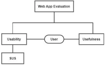
2. BACKGROUND AND RELATED WORK... 6
2.1. Location-based Services ... 8
2.1.1. Location-based Services for Navigating Mental Disorders ... 9
2.1.2. Location-based Services for Monitoring State of Mental Disorders ....11
2.1.3. Location-based Services for Intervention with Mental Disorders ...13
2.2 Geofences ...15
2.2.1. Geofences for Treatment of Mental Disorders ...18
2.3. Technologies and Tools ...19
2.3.1. HTML, CSS, JavaScript ...20
2.3.2. Angular ...22
2.3.3. Firebase ...24
2.3.4. Foursquare Places API ...24
3. THE SYMPTOMS PROJECT ...27
4. SYMPTOMS EXTENSION WITH LOCATION BASED SERVICES ...31
4.1. Identifying the Location-based Service ...32
4.2. Features of Location-based Services and Integration Process ...34
4.3. The Web Application with Location-based Service ...34
4.3.1. Flow of Tasks to Use the Application ...35
4.3.2. User Interface of the Application ...37
vi 5. EVALUATION...43 5.1. Usability Evaluation ...44 5.2. Usefulness Evaluation ...46 5.3. Summary of Evaluation ...50 6. CONCLUSION ...52 6.1. Summary ...52
6.2. Research Objectives and their Respective Solutions ...54
6.3. Limitations ...55
6.3. Future Works ...55
7. REFERENCES ...57
8. APPENDICES ...62
8.1 Appendix A: Demo of the Web Application with LBS ...62
8.2 Appendix B: System Usability Scale (SUS) Form ...63
vii
INDEX OF FIGURES
Figure 1: Framework, libraries and tools used in this work ...20
Figure 2: Angular architecture overview (Angular, 2019) ...23
Figure 3: Overview of SYMPTOMS platform components and their interactions, based on (González A., et al. 2019) ...28
Figure 4: Web and Mobile Applications interaction with Firebase services in the platform, based on (González A., 2018)...30
Figure 5: The structure of SYMPTOMS Web Application with LBS ...31
Figure 6: Flowchart of the SYMPTOMS Web Application with LBS ...36
Figure 7: The general view of SYMPTOMS Web Application with LBS ...38
Figure 8: Foursquare API places search results (bars and casinos in Valencia) .39 Figure 9: Bars and Casinos with size changed ...40
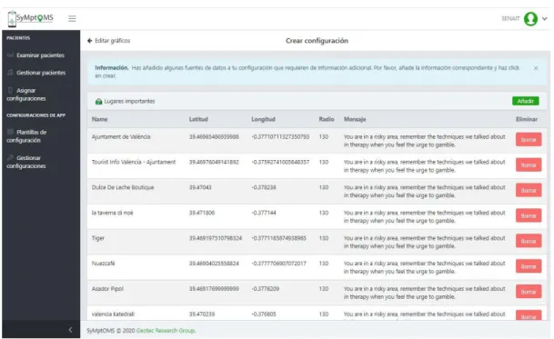
Figure 10: Saved configuration information of a patient...41
Figure 11: The general overview of the evaluation ...43
Figure 12: Comparison of SUS scores in grade scale, adjective scale ratings and acceptability ranges (Bangor et al., 2009) ...46
Figure 13: General usefulness and desire to use the application ...47
viii
INDEX OF TABLES
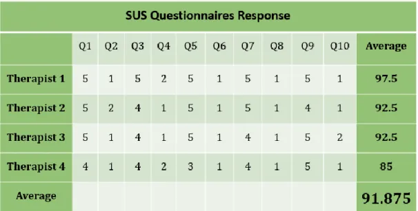
Table 1: Comparison between location-based services ...32 Table 2: System Usability Scale response with average score ...45 Table 3: Summary of responses for the open questions ...49
1
1. INTRODUCTION
Smartphones are sophisticated devices that are advantageous for the interaction of people with technologies since we carry them everywhere and they have data storage and processing capabilities. Providing location-based services utilizing built-in technologies like GPS receivers is one functionality of these devices. These all provide a mechanism to log and process geospatial data collected by patient’s smartphones (P. A. Prociow & Crowe, 2010). Using GPS enabled mobile phones to collect location and movement data of patients enables psychologists to assist the following time consuming and incomplete tasks such as interviewing patient’s, requesting to fill questionnaires, and observing behavioural changes to assess the state of depression of patients suffering from mental disorder (Grünerbl et al., 2012). This can be manifested from the collected geospatial data by evaluating changes in spatial movements such as spending less time away from home, visiting fewer places, or disruption to daily routines, and the type of places they have visited (Palmius et al., 2017). With the help of modern technologies, the cycle of data collection, data delivery, data processing and interpretation can be significantly improved. The core improvements that the current technological advancements may bring are briefly summarized as follows. Firstly, the utilization of mobile technologies (i.e. GPS, ubiquitous Internet connectivity) enable to accurately track and store user’s location and trajectories, and to interact, on real-time basis with the user (i.e. notifications). Secondly, GIS technologies allow easily analyzing and interpreting the collected mobility data, and taking appropriate actions (e.g. geo-fencing, trajectory analysis, etc.). Thirdly, visualization and visual analysis enable to visualize and interpret the data in such a way that it specifically supports treatments of mental disorder patients.
The Geospatial Technologies research group (Geotec) has developed a mental health application builder software platform, it has an application generations framework accessible via a web interface, which allows health professionals to generate a mobile application for the treatment of a mental disorder patients
2 (González A. et. al., 2019). The framework therefore offers some basic geospatial building blocks (location tracking, trajectory recording, geo-fencing), communication building blocks (location and time-based notification) and a basic visualization of collected data by therapists (chart- and map-based view). The framework has been successfully tested for building an application to treat patients with agoraphobia, addiction and depression.
Even though early successes confirmed the value of in-situ services (e.g. notifications), setting up such service remained cumbersome. Therefore, current therapies focus on a single or few places. Besides, therapists need to have good knowledge of the area where the patient lives in order to know the locations of places of interest and their details, for example, if the therapist doesn’t know the city, he/she may not know where the places of interest (bars, gambling places, parks, etc.) are located. This thesis aims to improve the process of defining the places of interest by integrating a location-based service in the configuration component of SYMPTOMS Web Application, which allows therapists to define multiple places of interest automatically based on location and categories of places of interest. Therapists won't need to have detail knowledge of the area (city), they can get list of places of interest and their details from the location-based service. Moreover, the work enables to define various types of places at the same time (e.g., bars and casinos), and allows to specify multiple places of interest in different areas which makes the therapy more universally usable.
1.1. Problem Statement
In the field of health, the location and movements of a patient is a key resource for the treatment of mental disorders (e.g. depression, agoraphobia, gambling addictions, etc.). Even these days, psychologists most often rely on pen and paper, asking the patient to carefully write down their location, movement, activities, states and habit. Despite the best intentions of the patient, such data could be very subjective and incomplete. And, this results in delay between data collection, delivery, processing and providing treatment. The SYMPTOMS
3 platform developed by Geotec resolves these problems by automating the cycle of patient’s data collection, data delivery, data processing and interpretation. The platform allows therapists to build a mobile application for patient’s treatment that provides location- and time-based interventions. For setting up this mobile application, therapists need to define the places of interest for patients such as bars, parks, gambling areas etc. There may be a lot of these places in one area and currently, therapists must define all the relevant places manually, one by one, which is tedious and time consuming. And therapists need to have detailed knowledge of the area, in other way, they cannot define such places in an area they don’t know. Moreover, this approach is not generalizable, unfeasible in bigger cities or for more elaborate treatments, when many places of interest may be relevant, and is difficult to use in different cities. Therefore, it is vital to provide assistance to therapists in this process, in order to improve the efficiency, feasibility and usability of the system.
1.2. Goal and Research Objectives
The main goal of this work is to improve a mental health intervention by integrating location-based services for better treatment of patients diagnosed with a mental disorder. Hence, to achieve this, the main objectives to be performed within the scope of this work are stated bellow.
The research objectives:
O1. Integrate location-based services to improve the treatment of mental disorder patients by making mobile application configuration process easier and faster.
O2. Improve the way of defining the places of interest to make the mobile applications more usable in different and larger places.
O3. Explore further use of location-based services in psychological intervention beyond the current stated functionalities.
4
1.3. Methodology
The methodological approach to achieve the defined goal is as follows:
1. Understanding the context of location-based services for mental health intervention and identifying the problems through explorative literature review.
2. Requirement determination for developing the application through having detailed discussion with Geotec members and exploring existing discussion results with professional therapists about the existing system. 3. Identifying types of places of interest for patients and finding data source for the work through exploring web services API for geo-data (places API).
4. Based on the requirements identified, extend the Web Application of SYMPTOMS framework by integrating a location-based service which enables therapists to define patients’ places of interest automatically. The Agile Scrum development methodology is used to manage the implementation process and create potentially deliverable product. Advanced web technologies and frameworks are utilized to implement the application (detailed information is stated in section 2.3).
5. Evaluate the usability and usefulness of the web application with location- based service.
• An experiment has performed with the help of professional therapists to test the usage of the application by allowing them to automatically define places of interest of patients while setting up the configuration.
• The System Usability Scale has been used to assess the interaction of the user (in this case a therapists) with the application, to know how easy it is to use.
• The usefulness of the application is evaluated using a custom questionnaire prepared to assess the functionalities of the specific
5 components of the application and to identify if there is a missing part to be improved for the future.
6. Analyse and interpret testing results (evaluation) of the application. 7. Writing report.
1.4. Outlines
The structure of this work is organized as follows: The first chapter is the introduction part of the work which states the problem statement, goal, research objectives and the methods used to achieve the research objectives. The second chapter is about background and related works. It explains LBS and its functionalities in psychological treatments, significances of geofences, and all the tools and technologies used in this work. Chapter three describes the existing SYMPTOMS platform which is extending with the proposed solution. In chapter four a comparison between location-based services and detailed description of web application with location-based service developed within the scope of this thesis is stated. Then, chapter five describes the process of evaluating the usability and usefulness of the application and discusses the results of the evaluation. Finally, chapter six summarizes the main points of the thesis and states the future work.
6
2. BACKGROUND AND RELATED WORK
The advancements in mobile based applications, Health Information System, and Geographical Information System are astounding assets for the development of Location Based Services (LBS) in healthcare. Health information systems provide detailed information about facilities of healthcare. Combining LBS with Health information systems results in a customized geospatial application which considers users preference (Poornima & Ganesan, 2015). Therefore, LBS can contribute to several benefits in the area of healthcare; ranging from navigating to obtain the closest healthcare facility based on user’s preference to providing improved interventions between patients and health specialists for better treatment.
These days, the quality of life has been observed to improve from time to time. Moreover, individuals are emphasizing more on securing their health. Thus, they seek for latest technologies for treatment at any time and place. Following this, the interest for remote treatment is showing higher increasing. A solution could be to develop a system that can detect patient’s location, monitor their status and provide real-time treatment distantly. That system with the above-mentioned functionalities as LBS could help rescuing patients more quickly. LBS enable the process and management of patient’s locational data remotely. Bearing this in mind, first-aid service can distantly be provided knowing patients location and status (Ahn, Heo, Lim, Seo, & Kim, 2008).
The systematic review of World Health Organization (WHO) in 2014 states that around 83 million people aged from 18-65 in European countries and 30% of the global population has suffered from mental health disorder in the past years. And 2–4% of the general population also suffers from bipolar disorder (World Health Organization, 2018). The condition of mental disorder can be described by two extreme patient’s activities. These are: depression phase with lower activity or inactivity and manic phase with hyperactivity and more talkative. These different activities can be indicated by assessing number of the most
7 visited places, type of places of interests and time spent at home or outside (P. Prociow, Wac, & Crowe, 2012). Based on the estimation of WHO, depression will be the second largest cause of “lost years of healthy life” worldwide by 2020. Besides, it takes months or years to identify and treat it with the existing healthcare system. Thus, the efficient way of monitoring depression is to make improvements on the delivery of location-based treatment utilizing mobile technologies such as smartphones equipped with powerful sensors which can continuously monitor patient’s context, including physical activity, location, and environment (Saeb et al., 2015).
The exponential growth in mobile phones that use GIS technologies have a great impact on the treatment of patients in healthcare. (Exler et al., 2018) noted that estimating whether a person is in company or alone is an important indicator for keeping track of patient’s mental health status in psychological treatment. This enhances the traditional methodology of assessing patient’s social activities which is using self-reported questionnaires. For automating this process of assessment, the embedded sensor of smartphones is suitable. Context-aware systems have better usability for mobile devices which can adapt their functionalities concerning user’s location and time.
The way of responding to smartphone notifications and interruption can affect social context of users. Furthermore, obtaining access to these changes in social context is important for detecting the current state and state change in patients with mental disorder for providing enhanced treatment. By monitoring certain places of interest and patient activities, through the configuration of time-related attributes, it is possible to detect whether a patient is in company or alone and based on this information it becomes easy to monitor their state change. However, combining patient location data with temporal features and activity information for detecting state change is not enough to improve patient’s treatments. Assessing patient’s psychological state and providing location-based notifications and intervention reduces time spent for patient-therapist communication and provide better treatment. The detailed
8 explanation of the term LBS and its functionalities in the area of mental health such as, navigating, monitoring states, and providing interventions are stated below.
2.1. Location-based Services
The term location-based service is a concept that provides applications which are resulted from the integration of the user’s geographic location and other information, based on mobile communication network. At the beginning, positioning system was used for military purposes and in later distributed all over the world freely and became usable by various industries to improve their products and services. With the emergence of mobile network and localization technologies the interest in location data for providing emergency service appeared. This was used to get the current location automatically from the mobile phone in the event of an emergency, for example. Now, it is applicable in service advertisements and service re-usability, transportation for navigating users, in tourism for tour planning and navigating tourists (Jochen Schiller, Agnès Voisard, 2004). LBS is one of the key functionalities of mobile phones, which enables users to retrieve the information about their current location and process that data to get more useful information near to their location.
With the increasing popularity of smartphones, fast Internet growth together with a rapid proliferation of social media services and users, the role of location in digital life is also changing. Smartphone users utilize location-based service for getting location-related information such as directions and targeted recommendations, and to share their location and activities with their friends. According to (Zickuhr, 2013) 74% of smartphone owners aged 18 and older use their phone for navigation and to get access for various information related to their current location such as getting geofenced notification like sales in shopping malls, information of traffic conditions, and patient treatment information when they are close to companies or service providers or when they enter to other places which are not allowed for them, respectively. And
9 30% of social media users used to tag their current location on their posts, and 12% of the smartphone users are using geosocial services such as Foursquare to “check in” to locations or share their whereabouts with friends. This kind of functionality is applied in many social media sites, which enable users to set up the services to tag their current location with their updates on the site (Liu, Chang, & Chen, 2009). The available usage of LBS in healthcare such as patient treatment, and providing emergency services is very limited. The functionalities of LBS in healthcare for treatment of mental disorder patients are discussed below.
2.1.1. Location-based Services for Navigating Mental Disorders
Navigation application is used to analyse and compile LBS information and provides detailed information of places. And this detail of places helps people to find and access the desired healthcare facilities quickly. To access LBS information mobile devices can use mobile network and utilizing these location aware devices users can find access to details of their surroundings, positioning technologies, and wireless communications. LBS can contain the users route information, store their location trace, provide map visualization, and directory services. Several governmental and private hospitals exist in one city, and they offer many specialized and non-specialized services. Introducing information system that helps to find routes and service specific information and checking availability of expertise in the healthcare can improve the non-specialized services. Using LBS helps to get the actual position of the healthcare centre utilizing spatial data and road network data of it, getting access of location, time and situation based available service and relevant information about the healthcare. This can assist patients by providing access to safety information, emergency service, information of travelling time and distance from their current location to the nearest healthcare based on their specific needs (Poornima & Ganesan, 2015).
10 In other cases, it is common to see people travelling for more than an hour or change different transportations to travel from their home to workplace and vice versa. People with mental disorder problems are always excluded from works market and considered as unable to work. With appropriate assistance, and training, several patients of mental health disorder can participate in work and social connection. Moreover, this plays a vital role in improving social interaction of the patients. However, while they are travelling caregivers or job coaches will be worried until they arrive at a desired place because they may still require assistance. Using an LBS system for navigating the patients and notifying caregivers as they have arrived at the targeted destination is very helpful. Therefore, patients need an understandable guidance or navigation systems when they travel from home to their workplace alone.
The location-based guiding and tracking service for mental disorder patients which can be used in public transit system was investigated by (Liu et al., 2009). It helps patients to perform different tasks on a personal basis and travel from home to their workplace independently. And their caregivers can monitor them being at other places or doing other tasks. In order to prevent the limitations of GPS which can fail to work in an underground place or indoor, the Wi-Fi signals were used for estimating the current location of the patients. The system was implemented as a mobile application and patients can use it while travelling with transportation. When the patient chooses a station to get off, the application displays a photo to show the right direction. The photo is based on the current location of the patient, which is to be compared with real place where around. It also displays a message window as a reminder to get off at the next stop. If the patient misses the get off stop or use a wrong direction it vibrates and/or sounds for 3 seconds to alert the patient, and it continues until the user presses “OK” button. Besides, the system can send a short message alert to caregiver for reporting whether the patient has arrived or not on schedule at a specified time and place (Liu et al., 2009).
11
2.1.2. Location-based Services for Monitoring State of Mental
Disorders
Different states of mental disorders can be monitored from their daily behavioural changes, activities and movements. This can be performed by collecting spatial and temporal data of the patients. Measuring behaviour is not easy as measuring temperature, and psychologists rely on paper-based questionnaires, interviews and observations to detect the state changes. Automated behaviour monitoring system could yield significant benefits in providing subjective and complete data for mental health diagnosis.
A state transition can be indicated by features derived from data of location, motion, and phone calls or social interactions of a patient. This can simplify the way of delivering effective interventions and guarantee availability of in-time treatment. Collecting patient’s data is easier using Android based mobile application. It can start automatically on device boot and works in the background without any user interaction. It can record GPS, Wi-Fi cell information, acceleration, compass, number of phone calls and visible Bluetooth
devices. The states of mental disorder can be depressive, normal, and mania. For
detection of these states, the ratio between times spent indoor and outdoor by the patients were considered as indicators. After evaluating location, movement and activity data, it is explained that patients who are always stay inside their home are in the state of depression, and patients spent more time outside and have different movement activities are in the state of mania. From the psychologists point of knowledge “manic people become quieter in normal state while depressed people become more active” and this is used to prove the above result (Grünerbl et al., 2015).
Identifying the levels of depression using location movement’s data, which is also recorded using an application installed in android mobile phone of mental disorder patients is performed. This was done to enable healthcare providers to monitor and identify those in need of treatment. It is demonstrated that the
12 assessment can provide a useful metric for the identification of depressive symptoms in mental disorder patients in community settings. The variability of time spent in different locations, moving between different locations, and percentage of time spent inside the home are used as indicators. Patients staying at home and visiting fewer locations were both shown to be strong indicators of severely depressed (Palmius et al., 2017).
The potential of utilizing geospatial information for early recognition of symptoms and providing mobile based therapy for patients is explored by (Prociow et al. 2010). Incorporating wearable and ambient sensors into patient’s environment could improve the way of identifying behavioral changes and create awareness of self-care. And this can result in potential means of monitoring the state and informing the caregivers, clinicians and the patients themselves about current mental state. This also enhances the self-awareness of mental disorder patients by enabling them to monitor their activities related to mental state. The patients positional and social interaction data were collected using a smartphone with GPS receiver and Bluetooth enabled. Density-based Algorithm was used as clustering mechanism for the geospatial data to discover meaningful locations which are most visited places by the patients. Unusual places visited and meeting more new people can also be monitored. If the patient was active for a long time like “restlessness and night terror” are also the main indicators of depression (Gravenhorst et al., 2015; Prociow et al., 2012).
The relationship between self-reported depressive symptoms and features derived from location and phone usage data was examined by (Saeb et al. 2015). For protecting patient’s sensitive data, encryption mechanism was used before storage and transmission. And the K-means clustering algorithm was used for identifying places where patients spent most of their time such as homes, workplaces, parks, etc, which are helpful to identify places of interest, monitor the level of depression of patients and detect risk states and places. Besides, monitoring behavioural changes related to movement through space, mobile
13 phones can enable assessing the changes and monitoring of at-risk population for providing just-in-time treatment through interventions.
Patients who stay longer in clinic meant that they were feeling more depressed or vice versa. In fact, patients with more severely depressed tend to stay longer in the clinic till they recover (Sabatelli et al., 2014).
Having detected places of interest, state changes in behaviour, movement activities and social interaction of patients are not enough for better treatment of patients. Reducing the manual process and providing location-based services through professional interventions for improved treatment is necessary.
2.1.3. Location-based Services for Intervention with Mental
Disorders
The process of monitoring patient’s state is not enough to treat mental health disorders. Based on the detected states, providing time and location-based treatment services is helpful. A location-based and participatory approach which provides an early mental health services for individuals during disasters is developed. “cellphone-type teleoperated android robots” was used and it was connected to a central system where volunteer mental health professionals were available. And this has a great impact in solving the problem of lack of access to adequate mental-health professionals. To make GIS web services more flexible and overcome limitations of centralized services, the techniques of using a peer-to-peer system architecture in providing location-based services are studied. A robot called Elfoid was on the hand of the patients which conveys them the presence of the mental health professionals who are in remote location using voice, appearance, touch, and motion. A geographical web service was developed to provide an emergency mental health support services to patients in the time of disaster event. The way of using the service such as consultation can be started by the service receiver users by using the robot to connect to the web service or the service provider users (professionals) can use the location-based service for looking the robots which are spatially located
14 inside the disaster-affected area and provide a psychological treatment service. The system also works in allocating nearest medical centres or field hospital and prioritizing service receivers based on their levels of mental vulnerability (Vahidi et al., 2014).
User’s physical activity such as walking, running, biking, stationary biking and changes in geographic range are helpful in assessing mental wellness. Decreased physical activity is also an indicator of depression level. Detecting changes in mental well-being and providing “context-aware micro-interventions” to patients at the time and place they need it and helping them to develop their understanding about their illness for introducing enhanced self-tracking improves treatment. When patients become aware of their illness and could identify their symptoms, it can create the opportunity to provide just-in-time interventions for better treatment (Matthews, Abdullah, Gay, & Choudhury, 2014).
A location, community and time based mobile social network services (MSNSs) is developed to improve social connectedness and quality of life for people with mental impairments. MSNSs works on Personal Digital Assistant (PDA) carried by the patients to provide them assistance; when they get lost, became confused on their way or in case they are sick and needed treatment. It uses map web service from map server to process and display the current location of a patient on a geographical map viewed on a web page. When a patient asks for help (push help) the system compares the patient’s need and service providers’ expertise, working hour, and availability. In case of matching, the system returns lists of service providers. Then further processing is undertaken to identify which care provider should respond to an emergency call. Then the identified service provider gets a request to offer the service (Chang, Liu, & Wang, 2009).
The MSNSs system also tracks the person who deviated from the pre-set route to the targeted place, and then tries to locate the caregivers who are within a certain distance from the lost person depending on the patient’s preference and
15 available caregivers. Then a short message is sent to the matched caregivers, and to the patient to inform to stay calm. The system has an active alarm with which a caregiver can mark a region for targeted place and set target time then the patient get notified if they haven’t reached at the specified place and time or if they leave workplace unexpectedly and the caregiver also get a notification of place change and arrival or not (Chang et al., 2009).
Geotec has developed a location-based and context-aware platform to provide improved treatment for mental disorder patients. As an extension of this platform (Gebreegziabiher, 2019) investigated on providing interventions between patients and therapists to enhance the treatment by sending automated location- and time-based messages and questionnaires to patients. The existing location-based notification system was extended to use context-based triggers and assess patients state ubiquitously for providing improved psychotherapeutic interventions. When the patient enters/leaves a fenced place or stay more than specified time in targeted place the application automatically sends a supportive messages or questionnaires based on the location to assess the current emotional state and provide a required treatment.
2.2 Geofences
Users can get access to location-based services which originate from the geographic location of their mobile device. It is possible to trigger these services when the mobile device is at a specific location. In order to satisfy the location-based requests such as finding areas of interest, checking traffic conditions, finding our friends, assets, resources, machines and emergency requests, the service can originate from the mobile device itself or another entity like application provider or network operator (Sathiyavathi, Vimali, & Sasikumar, 2014).
Modern mobile device platforms have better location tracking functionality which is an important feature for mobile applications that require knowledge of whether a user is entering or exiting defined geographical areas. And most
16 location-based services are often based on an area or place not on accurate determination of precise location. Based on the observation that users move from one place (for example, commercial properties, homes, office centres, etc.) to another and then stay at that place for a while, an event can be fired to notify the user.
Geofences are a virtual fences or perimeters around physical location established automatically based on the location of an asset along with a range or distance to enable remote monitoring of geographic area. It is used to detect when someone comes in or leaves the given region and to trigger events. When this happens, it is possible to trigger events and actions such as sending notification to the users’ mobile phone. Every time a user moves around with the mobile phone, a new position is calculated from various sources such as Wi-Fi, cellular data, GPS, and Bluetooth beacons. Using the new calculated position an action can be triggered in case of enter or leave the geofences. These actions can depend on the coverage area by selecting centre point (longitude and latitude values), radius around the point, and may be an expiry time-out for an alert. And they can let the users know that they have entered the geofence, for instance by displaying a notification. However, they can also be silent without informing the user, such would be the case if we want to track how many times the user has come into the desired place and how much time they spend there (David C. McCoy, 2013; Namiot & Sneps-Sneppe, 2013). Geofences are applicable in several areas such as marketing by detecting user’s proximity to a shop and notify them of special offer in order to attract them, and to build profile of customer’s preferences by detecting the time spent at each part of the shop.
Geofences can also be used to display relevant content of a place, such as in a museum to display information relevant to the place that the user is looking at. We can define any type of actions when the user enters or leaves any of the geofences and can also perform analysis on the user’s behaviour. We can use it also for advertising products, when customers download and install the application of their favourite product store or subscribed and enable location
17 services the next time they pass by that location they might get a coupon, a promotional ads or a simple reminder to drop in. To see when employees enter or exit workplace or to ensure only verified employees can access secure areas. As location tracking is an important technique for preventing theft of assets or recovering stolen assets, geofences can be valuable in tracking vehicle’s location. Owners can track their vehicles and get an alert notification in case the defined geofence is violated by the driver leaving the boundary. Authorities looking for stolen vehicle can also use the ongoing location tracking to find it (Raynaud-richard, 2010).
Using GIS technologies an event may also be alerted for preventing undesirable circumstances and hazardous materials from entering a high-density population area. Predictive geofence systems are helpful to prevent accidents of conveyances by predicting the geofence crossing for a specified distance and time horizon. This predicts the distance of an object to travel for a set of time in the future by comparing the distance between the geofence and the object with the distance-horizon. By storing spatial characteristics of objects such as position, speed of travel, and direction of travel in a database, the system can predict the future position of the object by processing this stored information. And a notification alert can be generated if the predicted future positions of the objects result in a geofence crossing (Jason T. Putz, St. Louis, 2013).
With the increasing availability of smartphones and their advanced services, users can control power consumption and prevent unintended interruption at public places or remote areas. Geofence services enable remote control and automated operations based on the user’s current geographic location. Users can define one or more geofences based on the location determined by their mobile device.
Using geofence applications mobile devices volumes or power control settings can automatically adjust based on the user’s current location inside or outside of a geofence. In another example, it is possible to selectively control the temperature setting of a building or a house based on the user’s proximity to the geofence defined relative to the building. We can also automatically activate or
18 control electrical appliances within a geofence (within a house) based on the user’s current geographical location relative to the geofence (Clara et al., 2017).
2.2.1. Geofences for Treatment of Mental Disorders
The presence of technologies such as advanced features of smartphones, digital maps, and geofencing techniques has changed in the way people do activities. For example, parents monitoring their children’s activities, caregivers or therapists monitoring activities and movements of mental disorder patients, and business owners controlling activities of employees (Raflesia, Lestarini, Taufiqurrahman, & Firdaus, 2017).
A continuous GPS tracking device is helpful for mental disorder patients by minimizing the risk of entering dangerous areas and to help keep them safe and secure. This can release the burden and worries of caregivers. These devices use a GPS module to receive patient’s location data from satellite and then transfer the real-time location to a central server. By comparing the locations with the defined geofence that is safe zone, a timely intervention triggers from a caregiver if necessary (Hadwen, Smallbon, Zhang, & D’Souza, 2017).
Geofence also helps caregivers to check if patients are inside a defined area, it could be home, clinic or workplace, while travelling to check if they are following the right way, and if they reach to the desired area with in the specified time by getting a notification if the conditions fail to fulfil.
Using interventions, it is possible to increase human engagement and connections with natural environment, which are widely accessible and cost-effective ways of improving human well-being and reducing health inequalities. As of European Environment Agency recommendation, people should have access to green space within a 15-min walk from their home. The World Health Organisation states that urban green space is a “necessary component for delivering healthy, sustainable, liveable conditions” (World Health Organization, 2016).
Having access to green areas close to home provides day-to-day stress relieving effects by reducing anxiety and stress hormones. Through GPS positioning and
19 geofences of green areas, providing interventions to encourage mental disorder patients to stay inside the natural environment is helpful. The intervention could be by sending messages to enjoy the area, questionnaires to respond their feeling inside the area, or warnings about something not allowed for them (Borgi et al., 2019).
In general, all the reviewed works show that geospatial applications in psychological treatments have less but good progress. Almost all of them provide different features such as detecting patient’s location and state level, and some involve with limited interventions. Moreover, there is a possibility of marking targeted place (geofence) and time to receive notification of encountering one. But still now there are many limitations and manual works which can delay the treatment.
The applications of the Geotec platform can provide automated treatment techniques by reducing cycle of data collection, automate data processing and delivery so that therapists can easily visualize and interpret the data. Thus, it enables them to provide time- and location-based improved treatment based on the analysis result. With the current applications of the platform some configurations are not fully automated. This thesis aims in integrating location-based services by allowing therapists to automatically define multiple places of interest of patients.
2.3. Technologies and Tools
For developing a web application with location-based service, various types of technologies can be utilized depending on the functionality of the application ranging from providing an interactive and user-friendly interface up-to requesting, processing and visualizing geo-data from web services then providing services based on analysis result. To extend the configuration component of the existing Web application; client-side scripting technologies, server-side design, frameworks, libraries, cloud database, and web services are used (Figure 1).
20 Figure 1: Framework, libraries and tools used in this work
2.3.1. HTML, CSS, JavaScript
Client-side Scripts are used to generate a code that can be executed or interpreted by browsers without needing the server-side processing. Utilizing effective client-side scripting can significantly reduce the server load. It is designed to run as a scripting language utilizing a web browser as a host program.
HTML is a mark-up language and the fundamental building block of web
programming which provides the frame or structure to the web page. It identifies and describes the arrangement of various components of the document (TechDifference, 2018).
CSS is a style sheet which provides a way to design the graphic elements which
helps in making the appearance of the web application more attractive. It is used to control the fonts, colours, background images, line spacing, special effects and basic animations of a page.
The extension of the syntax of CSS called SCSS provides a better workflow for maintaining the style sheet and allows to use features that are not part of the CSS standard yet. It is a pre-processor and helps to reduce the amount of time to repeat a code and ensures writing clean, maintainable code for the future (Robbins, 2012).
21
JavaScript is one of the high-level and dynamic programming languages which
is relevant for object-oriented and functional programming styles. It is also one of the most popular and widely used programming languages in the world right now. It is growing faster than any other programming language and big companies are using it for building their entire applications. The syntax of JavaScript is obtained from the Java (first-class function).
JavaScript can perform the processes of making the scripts to interact with the user, manage the content which appears within the browser window, and handle and control the web browser. It is possible to merge scripting feature of an interpreter with Document Object Model (DOM) which is specified by the web browser.
JavaScript was invented for the specific purpose and for a long time it was only used in browser to build interactive web pages, but currently there are various frameworks used as server-side scripting technology. Utilizing JavaScript, we can build Web/Mobile Applications, Real-time Networking Applications like chats and video streaming services, command-line Tools, and Games. It was only used to run in JavaScript Engines such as SpiderMonkey and v8 (Mosh Hamedani, 2018).
In 2009 an engineer called Ryan Dahl created NodeJS which is a C++ program that includes googles JavaScript v8 engine, which provides service of running JavaScript code outside of a browser. Now, it is possible to pass JavaScript code to Node for execution, and this means we can build the back end for our web and mobile applications (TechDifference, 2018). Therefore, JavaScript code can be run inside a browser or in Node, both provide a runtime environment for a JavaScript.
Typescript is a superset of JavaScript which is planned to simplify development of large-scale JavaScript applications. Furthermore, it is an open source programming language that compiles directly to JavaScript code. It can be compiled with Typescript NodeJS package from command line and many IDEs support it without any setup requirements (Bierman et al., 2014).
22
2.3.2. Angular
Angular is an open-source, Typescript based framework designed for developing web applications. It makes web application development easier by providing applications clean structure that is easy to understand, maintain, and includes a lot of re-usable codes that can be reused in various applications. It also makes applications more testable. Automated test can easily be written, and various parts of the application can be tested. It is one of the fast-growing frameworks used for building single page applications and progressive web applications.
The first version was named AngularJS, which is a JavaScript based framework, designed based on the traditional MVC (model, view, and controller) architecture to write cleaner and more efficient code. It was maintained by dedicated (and highly talented) Google engineers, and it enables to write the application logic instead of making manual change on views and allows to decorate the HTML special mark-up that synchronizes with the JavaScript (Jain, Mangal, & Mehta, 2014).
Due to the drawbacks of AngularJS in performance and how things work under the hood, Angular development team keeps updating and release new versions. AngularJS uses the concepts of scope and controller or rootScope. This works by adding a variable which will be visible in view and controller. Instead, the main architectural concept of Angular is a hierarchy of components. Thus the concept of scope and controller in AngularJS are replaced by components and directives in the new versions (M, 2018).
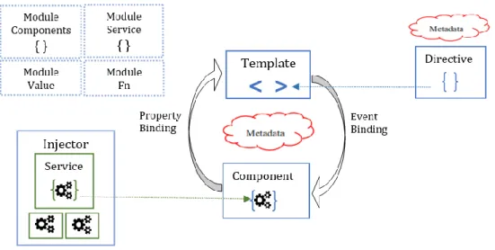
As shown in (Figure 2) each Angular application has at least one Component, the root component that provides the connection between components hierarchy and the page document object model (DOM). Each component of an application has a Typescript class defined to control an application data and business logic. It is also associated with an HTML Template that provides a view to be displayed in a target environment. For connecting the application data with DOM or component and template, the concept called data binding is used. Event Binding
23 is used for updating application data and Property Binding for interpolation of values, are types of binding. Metadata interprets whether a certain class is component or injectable and Directive instructs the template. Services are used in logic part for fetching data from server, validating input and so on (Angular, 2019).
Figure 2: Angular architecture overview (Angular, 2019)
Moreover, Angular is a structural framework used for developing dynamic web application. It provides an improved performance, reduces code redundancy, enables smooth migration, and makes developers’ life easy. Applications developed using Angular are modular and easily maintainable. Each component of the application can be updated independently, it doesn’t refresh the whole page. And this saves bandwidth and external files don’t load every time when page is loaded on each user action. Therefore, subsequent pages of the application load very fast (Jadhav. et al., 2015). Taking these advantages into account, the latest version Angular 8 is used for developing the location-based web application.
Libraries are a group of pre-compiled code or modules which can be used by multiple independent programs. They store useful modules that are frequently used and no need to write or link these modules in every program that uses them. To develop the Web Application various third-party libraries and Angular libraries are used, some of them are stated in (Figure 1).
24
2.3.3. Firebase
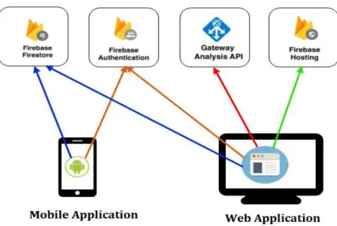
Firebase is a database service platform for mobile and web applications development that allows developers to efficiently deploy applications. It is a real-time database technology that provides hosted back-end services, allows to make web applications without server-side programming, and provides easier and quicker development. Firebase also provides the services of authentication, problem reporting, remote configuration, and hosting static files (see Figure 4). With very little configurations, firebase can take all the necessary steps; we don’t have to worry about managing server spaces and building REST APIs. It can perform the activities of user verification, data storage, and implementation access rules (Kumar et al., 2016).
Firebase have a nice coordination with systems like Angular. Accordingly, it is valuable, flexible, and allows us to make an application in a brief timeframe. Due to the cloud storage of data, Firebase database takes care of the real-time information update for the application. For data protection Firebase uses 2048-piece SSL encryption during exchange of information.
In Firebase data is stored in different secure areas to protect information loses, and it stores in the form of JSON. Applications can control and use data, without thinking about how it will be stored, and the synchronization various applications. Firebase supports the iOS, web, OS X, and Android clients (Kumar et al., 2016). Generally, Firebase saves a lot of extra time, and real-time functionality offers offline support for all types of users and provides data access from anywhere.
2.3.4. Foursquare Places API
The source of location data for places of interest is preferred to be Foursquare API based on a comparison between three location-based services (detail information is stated in section 4.1). Foursquare places API is a service that provides a real-time access to Foursquare’s global database of rich venues. It returns a JSON based detail information about places utilizing HTTP requests. It
25 is possible to get access to the API key for free, display places data in any map and easy to setup request. For getting granted with the API key (Client ID and Client Secret), the process is creating an account on their website, and create a new application (Foursquare, 2019).
Foursquare is a location data platform that consists of a user’s generated physical places for business and point of interests and enables users to share their whereabouts. Foursquare API allows developers to build applications with capabilities of place search and places details. According to (Foursquare, 2019), there are more than 50 million users and 150,000 partner companies (e.g. Uber, Apple, Samsung, and Twitter) are also registered to use Foursquare’s developer tools. It provides access for more than 62 million commercial places around the world through Application Programming Interfaces (API).
The primary source of information for Foursquare is users’ check-in through social networks utilizing mobile devices. The Foursquare venue categories changes every four months. The current top level pre-defined venue categories are Arts & Entertainment, College & University, Event, Food, Nightlife Spot, Outdoors & Recreation, Professional & Other Places, Residence, Shop & Service, Travel & Transport. And each category has several subcategories with more than 30 attribute fields as place detail. The attributes can include venue address, latitude/longitude, opening time, prices, photos, and other more information (Agryzkov et al., 2015).
Foursquare places API has several ways of requesting venues, and “Search for Venues” is one of them. The HTTP URL request has to be defined as https://api.foursquare.com/v2/venues/search?Parameteres.
The parameters are:
• Client Id and Client Secret: access keys
• near or ll: one of them is required. Near is a place name where we are looking for venues and ll is for longitude and latitude of a place.
• intent: one of the checkin, global, browse, or match
• sw, ne: latitude and longitude of South West and North East corners to limit results to a bounding box
26 • query: a venue type to be searched (e.g. bar, park, casino, etc.)
• limit: the maximum number of venues we want to display
For requesting more details of places there are also other optional parameters (Foursquare, 2019). Moreover, foursquare API allows up to 950 Regular API calls and 50 Premium API calls per day without providing credit card. By upgrading to Personal Tier Account and verifying a credit card, it is possible to increase the quota up to 99,500 Regular API calls and 500 Premium API calls per day. For unlimited API calls and points of interest the payment is only $599 per month (Team, Onsen UI, 2016).
27
3. THE SYMPTOMS PROJECT
SYMPTOMS (González A. et al., 2019) is an ecosystem of applications developed by GeoSpatial Technologies Research Lab (GEOTEC) with the psychological knowledge and experiment of the Laboratory of Psychology and Technology (LABPSITEC). This research group is aimed at researching and using geospatial and mobile technologies for mental health by developing innovative solutions for diagnosis, treatment, and prevent relapse of mental health disorders (Geotec, 2016).
SYMPTOMS platform enables therapists to specify, deploy and follow-up location- and sensor-based assessments and interventions for various mental disorders. It also provides a remote treatment utilizing the patient’s smartphone at any place (ecological) and time (momentarily). It has developed to offer a flexible and user-friendly Web interface by abstracting the technical details of configuration of the assessment and intervention in order to make it easily usable without programming knowledge. The flexible configurable platform consists of client-side applications (mobile application and web application) and set of server-side services (see Figure 3).
28 Figure 3: Overview of SYMPTOMS platform components and their interactions,
based on (González A., et al. 2019)
The SYMPTOMS Mobile Application is an Android-based application developed for patients. It monitors patients by passively (collecting built-in and external sensor data) and actively (collecting explicit patient feedback, e.g., questionnaires), and delivers interventions based on the analysis result of the collected data.
The SYMPTOMS Web Application is developed for therapists to register patient information, remotely configuring the Mobile Application, and to monitor the patient’s progress by visualizing a chart- and map-based analysis of the data obtained through Mobile Application. The configuration is specifying data of interests to be collected (e.g. sensor data or questionnaire), interventions that must be performed and its delivery condition based on the current context of the patient and analysis result of the collected data, and frequency of data collection.
29 The other component of the platform is the server-side services. It provides services of authentication, data storage, and analysis. All the collected data are accessible from the Analysis Services for extracting valuable information to improve the treatment of patients. The analysis could be about time spent inside and outside the home, patient mobility, and analysis of points of interest leave or enter. The Web Application can request and retrieve the analysis results by accessing the HTTP Gateway. Finally, the Firebase Hosting is used to upload the web projects of the platform (Figure 4).
With the existing applications of the platform, therapists can visualize and create a customized and personalised configuration of screened patients for treatment. Both applications use the Firebase Authentication services for personalizing the access and providing security (see Figure 4). And Firebase Firestore cloud database is used for storing patient information to be used by the application, treatment-based detail configuration performed by the therapists with the Web Application, and to store the sensor and location data collected utilizing the Mobile Application. The configuration is based on the information needed to be obtained from the patient which are basic for determining the conditions that must be met for intervention and content delivery.
30
Figure 4: Web and Mobile Applications interaction with Firebase services in the platform, based on (González A., 2018)
The platform can automatically activate the source of passive data collection (i.e., GPS, accelerometer, heart-rate monitor, etc.) utilizing the configuration engine of the Mobile Application based on the type of processed information that the therapist selected (e.g. number of times of home exits, time spent at a certain kind of place, anxiety level, etc.). The server-side analysis processes the collected data and therapists can access it through the Web Application to obtain valuable information. A treatment intervention can be triggered if conditions of captured data meet local analysis result (e.g. when the patient enters an area of interest), or changes detected in patient’s behaviour resulted from server-side analysis(González A. et al., 2019).
The reactive nature of the cloud database offers the capability to notify the changes performed by server- or client-side processes in the information stored within it. The Mobile Application can locally process the new data collected for determining if an intervention should be delivered. This results in reducing time between data collection (capture of an event) and the action taken, and no need to wait for periodically scheduled server-side analysis to decide on delivering treatment intervention (Gebreegziabiher, 2019).
31
4. SYMPTOMS EXTENSION WITH LOCATION BASED
SERVICES
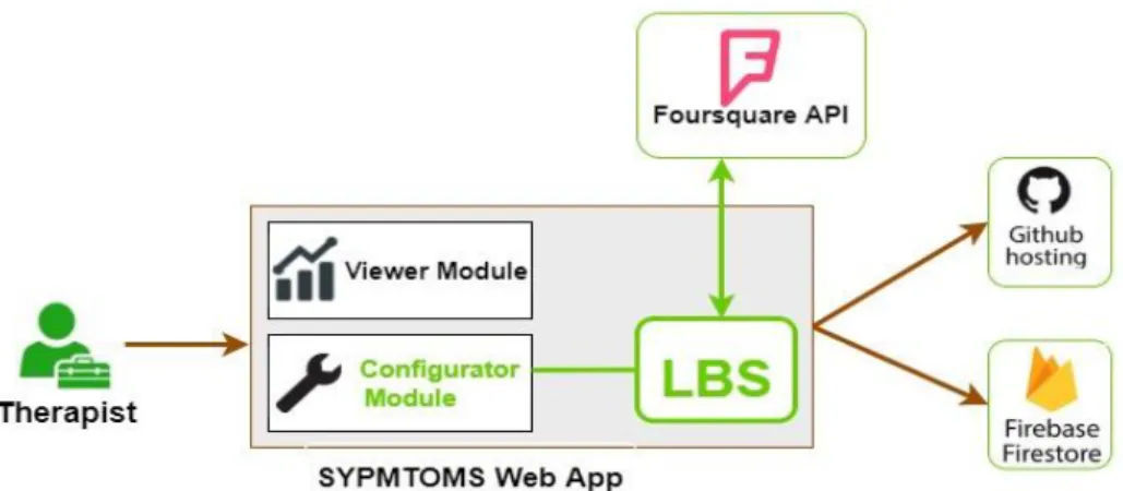
The existing SYMPTOMS Web Application helps therapists to provide the best location- and time-based treatment for mental disorder patients. It enables to consider the different levels of patient’s follow up and provides flexibility of generating improved mobile therapy. Furthermore, therapists use Configuration Module (Figure 5) of the web application for setting up the process of generating the mobile therapy. It allows defining places of interest, specifying conditions and types of interventions, and preparing the specific questionnaire or message to be sent to the patient in case the specified conditions are met. The Viewer Module of the web application enables to visualize location data, collected by patient’s mobile phone, and to view the questionnaire response from patients. However, in the case of defining places of interest, it is only possible to define one place of interest at a time. For example, if there are 30 gambling areas in a city that need to be defined as places of interest for a one gambling addicted patient, the configuration process must be done 30 times, which may be cumbersome, time consuming and error prone. Furthermore, as the therapist needs to manually indicate these places of interest, a good knowledge of the area is needed. To facilitate and automate this process, the SYMPTOMS Web Application is extended by integrating a location-based service (see Figure 5).
32
4.1. Identifying the Location-based Service
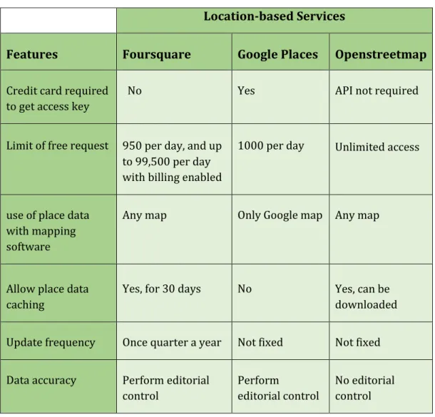
To identify the best source of detailed information for places of interest of mental disorder patients’, the comparison between three location-based services (Foursquare, Google Places, and OpenStreetMap) is performed. The following features were considered in the comparison: the requirement to get access key, the limit of free requests per day, use of place data with mapping software, place data caching, update frequency, and data accuracy.
Table 1: Comparison between location-based services
Location-based Services
Features Foursquare Google Places Openstreetmap
Credit card required to get access key
No Yes API not required
Limit of free request 950 per day, and up to 99,500 per day with billing enabled
1000 per day Unlimited access
use of place data with mapping software
Any map Only Google map Any map
Allow place data caching
Yes, for 30 days No Yes, can be downloaded Update frequency Once quarter a year Not fixed Not fixed Data accuracy Perform editorial
control
Perform
editorial control
No editorial control
To retrieve places data from Foursquare and Google Places, the API key must be included in all API requests. As shown in Table 1, providing credit cards and enabling billing is mandatory to get an API key and request places detail in