Esta obra foi licenciada com uma Licença Creative Commons - Atribuição 3.0 Não Adaptada.
AQUIFER RECHARGE: EPISTEMOLOGY AND INTERDISCIPLINARITY1
Vitor Vieira Vasconcelos2 Paulo Pereira Martins Junior3 Renato Moreira Hadad4 Sucharit Koontanakulvong5
Abstract:
The environmental issues related to aquifer recharge and discharge present challenges that require an interdisciplinary approach. This paper reports an epistemological study on the contribution of different fields of knowledge to the research on hydrogeological processes. The study is based on the hypothesis that this dialog is essential to the resolution of current and future environmental problems, including those related to water use. The first proposition is to discuss epistemological and information management approaches that may contribute to a better spatial, qualitative and quantitative characterization of aquifer recharge. Preliminary conceptual models are developed to demonstrate the possibilities of interdisciplinary collaboration to solve the environmental issues presented here. The paper concludes with a discussion of the possibilities of incorporating knowledge on aquifer recharge into environmental and water resources policies.
Keywords: Aquifers. Hydrogeology. Epistemology. Environment. Interdisciplinarity.
1
We thank FINEP [Financiadora de Estudos e Projetos (Funding Authority for Studies and Projects)], FAPEMIG [Fundação de Amparo à Pesquisa do estado de Minas Gerais (Minas Gerais Research Foundation)], CNPq [Conselho Nacional de Desenvolvimento Científico e Tecnológico (National Counsel of Technological and Scientific Development)] and CAPES [Coordenação de Aperfeiçoamento de Pessoal de Nível Superior (Coordination for the Improvement of Higher Level Personnel)] for funding the research projects that enabled the elaboration of this paper. This paper was developed in the PhD Graduate program in Crustal Evolution and Natural Resources of the Federal University of Ouro Preto (Universidade Federal de Ouro Preto – UFOP). We thank the Geology Department of the UFOP for hosting this research project.
2
PhD Candidate in Geology, UFOP, Ouro Preto, Minas Gerais, Brazil. Consultant in Environment and Sustainable Development of the Legislative Assembly of Minas Gerais, Belo Horizonte, Minas Gerais. E-mail: vitor.vasconcelos@almg.gov.br
3
PhD Candidate in Géologie Dynamique. Université Pierre et Marie Curie, LISE / CNRS, France. Full Researcher of the Technological Center Foundation of Minas Gerais (Fundação Centro Tecnológico de Minas Gerais - CETEC-MG). Professor in the Department of Geology of UFOP, Ouro Preto, Minas Gerais, Brazil. E-mail: paulo.martins@cetec.br
4
PhD in Computer Science at the Federal University of Minas Gerais (Universidade Federal de Minas Gerais – UFMG), Belo Horizonte, Minas Gerais, Brazil. Professor in the Graduate Program in Geography - Spatial Information Treatment of the Pontifical Catholic University of Minas Gerais (Pontifícia Universidade Católica de Minas Gerais - PUC-Minas). Pro-Rector of the PUC-Minas, Barreiro Campus, Belo Horizonte, Minas Gerais, Brazil. E-mail: rhadad@pucminas.br
5
INTRODUCTION
The topics of water infiltration into soil, the recharge and discharge of aquifers and the relationship between precipitation and groundwater flow have been addressed by a number of academic networks and communities. The departmental structure of academia often results in research centers that gather professionals with the same academic training, who specialize in a specific problem and therefore provide an expert response (ROCHA, 2003, p. 162-165). For example, there are research groups for aspects of the theme studied here in areas such as hydrogeology (stricto sensu), structural geography, geotechnics, hydrology, agronomy, sanitary engineering, environmental engineering, karst geomorphology, environmental management and urban planning.
Each research center develops techniques in its research projects that are related to different scales of approach and methods of analysis in research contexts that differ in the available human and financial resources and the time devoted to each research project, as well as other characteristics (MARTINS JUNIOR, 2000; SCANLON et al., 2002). This relative heterogeneity of the research groups results in a specialization of the conceptual and theoretical discourse over time (BAUER, 1990, p. 105-110) and, finally, different means of analyzing hydrogeological phenomena.
Parallel to the scientific progress that resulted from the disciplinary approach to knowledge (specialization), academia has recognized the possible benefits that may emerge from a dialogue between the different research centers. This recognition resulted in the valorization of interdisciplinary research. Typically, the interaction between different research areas enables a broader analysis of the issues to be studied (ROCHA, 2003, p. 169-170; ROCHA, 2004, p. 9). In addition, regarding the advancement of scientific knowledge, the exchange between research communities usually enables researchers to advance beyond the paradigms of each specific area through exposure to new approaches to a given problem (FLORIANI, 2004, p. 36; OLIVEIRA, 2005; SIVALAPAN, 2005).
Solving today’s environmental problems, which are often related to the management of natural resources, is a clear example of the need for interdisciplinary collaboration. As a means of interdisciplinary integration, Martins Junior (1998) suggests that the fields of knowledge that originate from geoscience be combined in
R. Inter. Interdisc. INTERthesis, Florianópolis, v.10, n.2, p. 360-409, Jul./Dez. 2013
interdisciplinary solutions to the sustainable management of a region. A number of environmental and epistemological studies have been performed using this approach (MARTINS JUNIOR, 2006; MARTINS JUNIOR et al., 2006; 2008; 2009; 2010; 2012), which demonstrated how land use management may be aided by a joint analysis of aspects such as aquifer recharge, agricultural suitability and vegetation connectivity as they regard both economic and ecological implications.
However, interdisciplinary dialog is not a challenge-free task. Such dialog is based on a detailed analysis of the conceptual meanings of each of the theoretical bodies of knowledge involved (BAUER, 1990, p. 113-115; FRANCELIN, 2011), which often includes clarifying different interpretations of the same word or expression (MARI, 2005). Transcending the concepts, the possibilities of links between the theoretical configurations and approach paradigms require detailed epistemological study (MARTINS JUNIOR, 2000; OLIVEIRA, 2005). These research efforts are not always easy in the academic and professional environment because they require changes in the custom of only valuing an expert in a particular field of knowledge and considering his/her field as inviolable (ROCHA, 2003, p. 172-178).
Thus, this paper discusses the epistemological aspects related to the possibilities of interdisciplinary dialog on the processes of groundwater circulation, with special emphasis on aquifer recharge. The paper starts with a discussion of the concepts and methods available for the different objects and scales of approach to this process. Then, an interdisciplinary modeling of this knowledge is proposed using diagrammatic and textual models based on information management technologies. The paper concludes with a discussion of how knowledge regarding aquifer recharge may support environmental and water resources policies.
EPISTEMOLOGICAL ISSUES REGARDING OBJECTS, CONCEPTS AND
MULTISCALE METHODS
Epistemological Fields and Conceptual Domains
knowledge and the studies involved but considering the main axes that resulted in structural advance in these scientific studies.
The semantic drift of concepts used in the communication between the fields of knowledge may mask biases that, when not divergent, at least focus on different aspects. One example is the concept of surface formation, which is important in delineating, in many bodies of knowledge, the object of study with respect to aquifer recharge and discharge. When used in agronomy and geomorphology, the concept of surface formation is related to the layer “composed of decayed material or weathered parent material covering the bedrock - therefore, it encompasses the
notions of soil and part of the subsoil” (GUERRA; GUERRA, 2006, p. 284). However, in geology, this term is often used in the field of surficial geology, where it incorporates the interpretation of formation as a category of stratigraphic classification. Thus, this concept emphasizes the correlation between rocks, structures, sedimentary deposits, weathered mantle and other outcropping geological features (JACKSON, 1997).
Box 1 – Epistemological fields of knowledge, research objects and classic questions according to professions and disciplinary specializations.
Research Area Scale of the Research Object
Classic Questions
Agronomy Soil profile Relationship between soil structure and water regarding the availability for plants and irrigation.
Geotechnics Weathered mantle Relationship between water and soil structure regarding stability or risk for occupation Hydrology Isotropic (spatially
homogenized) hydrographic basin
Water balance for the
calculation of water availability and flood control in projects of human water supply and reservoir construction Mining
Engineering
Surface geological formations
Lowering of the water table for mining
Geochemistry Groundwater flow Characteristics of the origin of water and its contamination Karst Geomorphology Route between dolines, sinks, cavities and resurgences
Role of water circulation in the genesis of the exo- and endokarst
Hydrogeology Aquifer Structural delineation of aquifer-bearing rock systems to support well drilling and exploitation
R. Inter. Interdisc. INTERthesis, Florianópolis, v.10, n.2, p. 360-409, Jul./Dez. 2013
hydrogeology also demands a number of epistemological adaptations.
For example, the cartography of lineaments, a subfield of structural geology, was developed primarily to analyze the direction and magnitude of tectonic stresses. Nevertheless, in the last decades many studies have attempted to correlate the density, direction and connectivity of lineaments with aquifer characteristics, under the hypothesis that the advance of tectonic stresses, which is related to an increase in the number of faults, will also increase aquifer recharge in anisotropic milieus (FERRIL et al., 2004).
However, Martins Junior et al. (2006) note that for the research to be minimally consistent, it would have to differentiate between the lineaments that correspond to ductile and brittle structures, thus differentiating their roles in the hydrological flow of the aquifer under study. In addition, CETEC (1981) emphasizes that studies that consider only the two-dimensional density of fractures may mask substantially more significant effects related to the spatial heterogeneity in the depth and width of these fractures.
Additionally, the normal, inverse and transcurrent tectonic movements associated with geological faults may cause discontinuities that block the hydrological flow of porous bedding, as noted by Gleenson and Novakowski (2009). An analogous case was observed in the Guarani aquifer in South America, where structural analyses of the Santa Maria and Piramboia Formations by Rosa Filho et al. (2003) and Soares (2008) demonstrated that understanding the movement associated with faults required a review of the preliminary models and calculations of recharge, flow and discharge (ROCHA, 1997), which had been based on the theoretical assumption of continuous porous media.
Scales of Approach to Groundwater Circulation
isotope analysis.
The variation in the spatial scale of the study objects reflects relevant epistemological implications. When methods employed for small experimental areas are expanded for larger areas, they risk not taking into account spatial heterogeneities, emergent properties and interrelationships between wider-scale processes.
For example, when applying a theoretical construct of a homogeneous soil profile structure to a large tridimensional extension of a specific environment, there is a risk that the variations of complexity due to scale will not be taken into account. Reggiani et al. (2000) propose that when traditional hydrogeological flow equations are applied to hydrographic basins, those equations must consider a system perspective that incorporates the feedback between the processes involved in the water balance and the variations in the pressure of the hydraulic gradient. For this purpose, the authors demonstrate that the emergent properties may be estimated by a thermodynamic approach, including an assessment of the system’s entropy.
In another consideration of this subject, Sivalapan (2005) proposes a focus on the identification of patterns, processes and functions at the scale of the larger basins that encompass the different data on and models already available for small basins. This approach would be an alternative to the current strong reductionist approach to research on water resources (at the spatial scale and in disciplinary specialization) and a step toward a more comprehensive theory.
Inter-scale Differences in Hydrographic Basins
At the hydrographic basin scale of analysis, the assessment of the hydrological and hydrogeological processes of different sub-basins must consider the area and position of the sub-basins in the topographic equilibrium profile because these processes change gradually from upstream to downstream areas.
R. Inter. Interdisc. INTERthesis, Florianópolis, v.10, n.2, p. 360-409, Jul./Dez. 2013
day (NAGHETTINI; PINTO, 2007, p. 8). As for the hydrogeological processes in these sub-basins, the hydraulic gradient conditioned by altitude results in the spatial predominance of areas with a more expressive recharge, even though this typology of discharge is also relevant in the spring sites (MARTINS JUNIOR et al., 2009).
Moving downstream from the top of the hydrographic basin, the recharge and discharge processes tend to reach equilibrium, forming what Souza and Fernandes (2000) refer to as a transmissivity (or transience6) area. Further downstream, the
accumulated discharge of local and regional hydrogeological processes continues to provide an increasingly stable participation of the baseflow in the total flow of the riverbed. The greater the extension of an underground aquifer is, the more important and complex is the research regarding its structural and lithostratigraphic geology, which aims to confidently delimit the tridimensional outline and the anisotropy of the porous, fractured and karst media, as well as the distinction between the local and regional hydrogeological flows.
In larger-sized basins, the frontal precipitation has the greatest effect on recharge and flow. Additionally, the influence of this precipitation depends on whether the instability front moves from upstream to downstream or in the opposite direction (TUCCI, 2009, p. 393). In addition, the occurrence and extension of flood plains and the accumulated effect of friction along the hydraulic course of the riverbed affect the analyses of flow and recharge (TUCCI, 2009, p. 601) by the seasonal variation in riverbed siltation as opposed to lowering (CHEVALLIER, 2009, p. 512-513) and by cushioning the flood waves (SILVEIRA, 2009, p. 44). Such phenomena also result in sequential evapotranspiration and infiltration at marginal lakes and hydromorphic alluvial soils (TUCCI, 2009, p. 249).
Therefore, studies performed in only one isolated basin may result in uncertainties regarding their application in other basins, especially at other scales of approach. Sivalapan (2005) emphasizes that the progress of hydrological and hydrogeological science demands a methodological reorientation such that studies on hydrographic basins are conducted on a system of nested basins whenever possible. In this way, the evaluation of a hydrogeological process would have to be
6
measured at different points throughout the hydrographic basin, while subdividing the data by sub-basin to assess how this process varies with the increase at the basin scale.
Soil Drainage as Object of Interdisciplinary Dialog
The issue of specialization and of the possibilities of interdisciplinary dialog may also be addressed from the variables and attributes measured in the research projects. When interpreting the water flow in porous media, the variables used by the different academic communities clearly show how the same subject may be approached from different ways. Pedology (Soil Science, understood both as the basic soil survey and as the study of agricultural suitability) and slope profile analysis (employed with different, but complementary, focuses in Geotechnics and Structural Soil Analysis) comprise such an example, and an approximation of their concepts is shown in Box 2. In this box, each column corresponds to a disciplinary approach (Soil Survey, Agricultural Suitability and Slope Profile Analysis), whereas the arrows show the interconnections among the variables studied in each of these approaches. Thus, Box 2 shows the possibility of interdisciplinary dialog between the theoretical matrices as a way of contributing to a deeper understanding of their study objects.
Other concepts are potentially of interest when the relationship among soils, plant cover and aquifer recharge is considered, even if these concepts are not always directly related to aquifer recharge in conventional academic studies. Examples are the concepts of moisture profile and capillary tension, as well as the attributes described in the center column of Box 2. As phenomena such as interception, evapotranspiration, infiltration and surface runoff are influenced by the vegetation type, the aspect of soil water availability may transfer to the study of
R. Inter. Interdisc. INTERthesis, Florianópolis, v.10, n.2, p. 360-409, Jul./Dez. 2013
Box 2 – Comparison between the variables used in pedology, agricultural suitability and slope profile analysis, based on Martins Junior et al.
R. Inter. Interdisc. INTERthesis, Florianópolis, v.10, n.2, p. xxx, Jul./Dez. 2013 Observations regarding Box 2:
* applicable to soils (Structural Soil Analysis and Geotechnics) and to rocks bearing aquifer
reservoirs.
** the impermeable terrain presents problems to agriculture and is inferred from the profile’s
internal characteristics (underground impermeable horizons, or 2:1 clays in plain topography or
depressions) and external characteristics, such as the general topography of depressions. This
requires the observation of the terrains of marginal lakes, of flood plains, of shallow depressions
and of hydromorphic soils in general.
When recovering principles of Structural Soil Analysis, Queiroz Neto (2000), Santos (2000) and Juhász et al. (2006) demonstrate the limitations of conventional soil studies that only examine the vertical variation in the soil profile without emphasizing the horizontal and sub-horizontal processes, such as slope, the subsurface lateral flow of solutions and free aquifer runoff in the soil’s saturated zone. Regarding this topic, when interpreting soil within the context of slope and hydrographic basin, Reggiani et al. (2000, p. 1861) emphasize the necessity of performing new studies that involve the circulation of water as vapor, from the saturated and unsaturated zones to the surface (considered as soil evaporation), while taking into account the vertical heterogeneity of the soil horizons. This author also notes the necessity of correlating on wider spatial scales attributes of slope, hydraulic gradient and soil evaporation (REGGIANI et al. 2000, p. 1856).
Drainage (or internal redistribution) is an attribute used in soil surveys that is
of interest for soil water flow. The concept of drainage refers to the dynamics of water spread in the soil profile in response to the gravity and pressure gradients after the
infiltration phenomenon has ceased (SILVEIRA et al., 2009, p. 356). This variable was initially formulated to characterize whether the soils would display a reaeration ability (by water runoff and desaturation) after precipitation events (including irrigation) so not to hamper the growth of agricultural crops.
may encompass the processes that result from parameters such as permeability, structure and conductivity but on a wider scale that includes the storage capacity of the soil profile, the variation in the water table and the flow processes in the hydrogeological basin.
Specialization and Transdisciplinary Dialog in the Study of Aquifer Recharge
Reanalyzing Box 1 and the previous considerations, it must be acknowledged that hydrogeology and hydrology have become, in many research centers, areas in which the knowledge produced by other academic communities has converged. Therefore, these convergence areas have had the opportunity to develop a valuable interdisciplinary nature. However, the opposite route is also necessary in order that scientific progress in the aquifer recharge field, which has been achieved by hydrogeology and hydrology, may be applied by other fields of knowledge that contend with environmental and agricultural issues. This issue will be addressed in later sections of this paper.
The need for internal specialization by hydrogeology (including hydrology) research teams has resulted in specialized technical and scientific knowledge domains. One noteworthy specialization is that of the mathematical-statistical modeler, in contrast to the professional who interprets field data and systematizes them in geographic information systems.
In large-scale research projects, these functions are often performed by different professionals or different research teams (HOLTSCHLAG, 1997, p. 3; FLYNN; TASKER 2004, p. 24). In such projects, the field geoprocessing team transfers the measured and processed environmental variables to the mathematical-statistical modelers. The modelers then construct the relevant models by contrasting these spatial input variables with the variables related to water and hydrogeological measurements.
R. Inter. Interdisc. INTERthesis, Florianópolis, v.10, n.2, p. 360-409, Jul./Dez. 2013
programming.
Conceptual and Empirical Hydrogeological Models
Transcending the different approaches used by different departments, the theoretical constructs may also be analyzed using more general epistemological models. Novaes (2005, p. 9-15) differentiates between two categories of hydrogeological and hydrological models: conceptual and empirical.
The functions of the conceptual models are constructed based on concatenated observations of the physical processes described in the literature regarding the hydrogeological cycle (NOVAES, 2005, p. 11-12). The methodological issue faced by these models is that given their need for a relatively large number of variables and measurements in space, their application in larger spatial dimensions becomes more difficult. This difficulty is even larger in developing countries, which do not possess sufficiently detailed hydrological and environmental databases (SIMMERS, 1988, p. 7). Given the difficulty of obtaining the parameters required by these models, they are often based on estimates, which diminishes the degree of certainty of the models (NOVAES, 2005, p. 12).
Another criticism is that a large number of conceptual models are formulated and calibrated based on the environmental processes of the temperate countries of the Northern Hemisphere, which results in significant errors when these models are applied to other contexts, such as tropical areas (ANDRADE et al., 2006, p. 24). The required calibration of these models to the context of tropical basins may distort the original models beyond acceptable limits. In addition, this practice prevents learning from patterns that could potentially emerge from new observations in these basins (SIVALAPAN, 2005).
Empirical models, in contrast, begin with the cause-and-effect relationships between the input and output variables and then calibrate functions that indirectly simulate the physical processes involved (TUCCI, 2002), in a black-box-type approach. Typically, the models involve multivariate analyses, such as neural networks and principal components analysis, applied to stochastic hydrological data.
or groundwater flow, or less often baseflow), the calibration process results in infinite combinations of the variables that plausibly pertain to hydrogeological basins, which produces uncertainties in parameter definitions. Such uncertainties are potentiated by the frequent spatial correlation among environmental variables, as a result of the joint bio-pedo-morpho-litho-climatic formation history of each local ecosystem (RETALLACK, 2008).
To reduce the number of uncertainties found in the empirical models, Clarke (2009, p. 667-668) recommends that parameters be included parsimoniously. Therefore, it is important to use quantitative statistical methods to assess whether each new variable should be included. This economy of constructs may be performed by using variables that are correlated to systemic spatial variables, such as the area of the hydrographic basin, altitude position in the equilibrium profile and evapotranspiration. However, the use of a smaller number of variables not only
results in more spatially homogeneous (simplified) results but also complicates inferences regarding the role played by different environmental parameters in the given hydrogeological process.
INTERDISCIPLINARY MODELING OF AQUIFER RECHARGE AND DISCHARGE
This section proposes a textual and diagrammatic modeling approach that encompasses the different information originating from the knowledge domains involved in the environmental analysis of aquifer recharge and discharge. This model is intended to provide an integrated and epistemologically consistent view of the encompassed knowledge. The computational formalization of the knowledge on aquifer recharge presented below consists of the work of the CETEC-MG (Fundação Centro Tecnológico de Minas Gerais [Technological Center Foundation of Minas
Gerais]) and the UFOP (Universidade Federal de Ouro Preto [Federal University of Ouro Preto]) joint research team, which includes this paper. The studies of this research team were documented by Martins Junior (2006; 2007) and Martins Junior et al. (2009) and synthesized by Vasconcelos et al. (2005; 2011) and Martins Junior et al. (2006; 2008; 2010).
R. Inter. Interdisc. INTERthesis, Florianópolis, v.10, n.2, p. 360-409, Jul./Dez. 2013
well as knowledge regarding the explicit textual content or the tacit knowledge of the researchers. The formalization of the knowledge modalities and their logical typologies are crucial in defining the possibility of using information models and tools to solve the problems related to groundwater circulation.
The modeling was performed by stages based on information science methods, such as conceptual maps (SOWA; MOULIN; MINEAU, 1993), SisORCI/SisARCQ (MARTINS JUNIOR et al., 2006; 2007), CommonKADS (knowledge acquisition and documentation structuring) (SCHREIBER et al., 1999), Unified Modeling Language (UML) (BOOCH et al., 1999) and knowledge representation (SOWA, 2000). The conceptual models introduced here were elaborated based on advice from expert researchers and review of the technical literature. The models are not intended to provide complete coverage of the fields of knowledge but aim to represent the connections that were deemed most relevant.
Box 3 presents a preliminary integration that indicates how the different fields of knowledge may contribute to the study of aquifer recharge areas. The box uses aquifer recharge zone (ARZ) and precise recharge area (PRA) as defined by Martins Junior et al. (2006, p. 652). An ARZ corresponds to an area in which infiltration plays a significant role in the hydrogeological cycle. Such areas are clustered geographically based on pedological, geomorphological and lithostratigraphic studies and recognized on a regional scale. PRAs may be recognized at a more detailed scale within the ARZ context and therefore require more comprehensive studies that include the delimitation of the aquifers and the groundwater flows.
Using the method of interdisciplinary matrices (MARTINS JUNIOR, 2006), Box 3 facilitates the visualization of how the different disciplinary approaches may interact in an articulated manner, thus increasing the knowledge on a given environment and revealing previously implicit or unnoticed correlations. This method consists of listing (in the rows and columns) the different knowledge areas and approaches. The potentially interdisciplinary and transdisciplinary concepts, objects and relationships are emphasized in the cells that correspond to the intersection between rows and columns (VASCONCELOS et al., 2005). This method was also used in the elaboration of Box 4, with the goal of better examining the possibilities of the interdisciplinary integration of the environmental issues related to aquifer discharge and recharge.
related to hydrogeology, environmental studies and land use by defining their axes of interdisciplinary integration. According to Martins Junior et al. (2008), such axes arise largely from the spatial topographic connections, as well as from the topological connections between the environmental systems and the fields of knowledge involved. Box 4 shows potential pathways for the use of the parametric variables and those variables related to measurable processes. The aim is to model the ideal conditions for land use by means of the “permission x impediments x specific
R. Inter. Interdisc. INTERthesis, Florianópolis, v.10, n.2, p. 360-409, Jul./Dez. 2013
Box 3 – Topics related to the specialist scientific fields and to the central issues of land use in ARZs and PRAs. Adapted from Martins Junior et al. (2010).
Scientific fields
and topics Hydrostratigra phy Structural geology and Geomorpholog y Pedology (Soils) Soil Suitability
for Agriculture Geotechnics Climatology
Hydrodynamic modeling Hydrogeoche mistry Central questions
Location of the ARZs Stratigraphy; delimitation of fractured, karst and porous aquifers Geoformations; topography
Soil types by drainage classes Types of suitability Surface formations Precipitation; temperature; evapotranspirati on; agroclimatologi cal maps Separation between surface runoff and baseflow Contamination sources; risk areas; water use sites
Location of the PRAs Detailed stratigraphy; delimitation of aquifers, aquiperms (aquitards and aquicludes) Slope; position on slopes; lineament density; brittle and ductile structures
Soil types by first-level classification
Correlation between soils and vegetation;
optimal use x effective occupation Geotechnical risks; erodibility; soil saturation Floods; photoperiodicity ; slope exposure; water balance Infiltration modeling; sub-surface runoff Families of groundwater that may become polluted Geoenvironme ntal characterizatio
n by ARZ and PRA type Petrography; weathering; sedimentology. Geoformations; geostructures; elluvial, colluvial and alluvial cover; gap size
and depth of brittle structures
Soil types by detailed-level classification; physical properties Technological implications for
soil and water conservation; suitability studies; indicator species Hydrogeochemi cal flow in slopes; soil
physical properties; laminar or deep
Box 4 – Groups of variables appropriate to integrating the interdisciplinary concepts applicable to the relationships hydrogeological processes x soil use type x environmental conservation. Adapted from Martins Junior et al. (2008).
Groups of variables
Hydrology /
Hydrogeology Geology Geomorphology
Pedology
(Soils) Botany Agronomy Geotechnics
G 1 – Fluvial
environments Specific subsurface flow
Quaternary detritic alluvial deposits
Minor, major and flood riverbeds.
Hydromorphic soils; alluvial
neosols
Riparian forests Irrigation
G 2 – Topologic and topographic correlations for aquifer recharge
and discharge
Drainage network; surface runoff after rain;
infiltration; surface baseflow; evapotranspiration. Porous formations; permeable brittle structures Cartography of the various geoformation types Cartography of the various soil
types Vegetation formations; ecosystems; phytogeography; phytosociology
Areas of iso-suitable soils;
soil drainage
Geotechnical risks; porosity; void index; moisture content,
natural density; degree of saturation
G 3 – Water quality Recharge zones; hydraulic gradient Lithostratigraphy; structural modeling; geochemical signature
Buffer zones Infiltration of
agricultural input
G 4 – Resurgence
typology Flow in springs
Rock attitudes; resurgences from
fractures
Slope models for resurgences Hydrophytic and hygrophytic vegetation Irregular occupation of permanent preservation areas around springs Siltation
G 5 – Seasonal analyses
Surface and underground circulation
time; climatic cycles
Karst hydrogeological
cycles
Cycles and seasonality of plant
in general Cycles and seasonality of domestic plants Geotechnical risks during extreme climatic events
G 6 – Water use recession coefficient; Flow maintenance; Q7,10 Well prospection Dependency on ecological water output Optimization between consumption and recharge in irrigation
G 7 – Soil degradation
R. Inter. Interdisc. INTERthesis, Florianópolis, v.10, n.2, p. 360-409, Jul./Dez. 2013
Figure 1 shows an ontological diagram of the environmental issues related to aquifer recharge in a simple hierarchical multi-perspective (SHriMP) structure (STOREY et al., 2002) created using the Protégé software. Ontology corresponds to the network of entities and processes by which the subjects and communities organize theories and assumptions from culture in the broad sense to academic knowledge. Generally, to study ontologies is to define categories for objects that exist within the same domain (ALMEIDA; BAX, 2003) and therefore to create an explicit specification of a concept (CORAZZON, 2002).
The SHriMP ontological diagram presents an efficient approach to detailing classes and subclasses of entities. The visualization of classification systems is an important step for future modeling studies that will be more accessible to the programmer, such as the Unified Modeling Language (UML) (BOOCH et al., 1999). In addition, Protégé is practical because it exports directly to the Ontology Web Language (OWL) (SMITH; WELTY; McGUINNESS, 2004).
One limitation of ontological diagrams is that they do not enable an efficient visualization of conceptual topics. Additionally, they do not indicate the relationships between the entities. Therefore, concept maps are used as a complementary instrument. Concept maps may be understood as structures, diagrams or graphics used to represent the way a subject understands and learns about a given subject
(LIMA, 2004). Although these maps do not explicitly represent a term’s semantic
content, they may be a powerful instrument to transmit a semiotic diagram that will be more efficient in recovering information and building knowledge.
In addition, concept maps aim to support the learning process (LIMA, 2004) by indicating the interrelationship between concepts and the interdisciplinary view. Starting from a universe of information, the concept map helps to concatenate ideas and to produce a more ample and systemic view. Thus, the concept map enables the acquisition and transmission of knowledge by making it easier to perceive contradictions, paradoxes and flaws in the organized content.
interest.
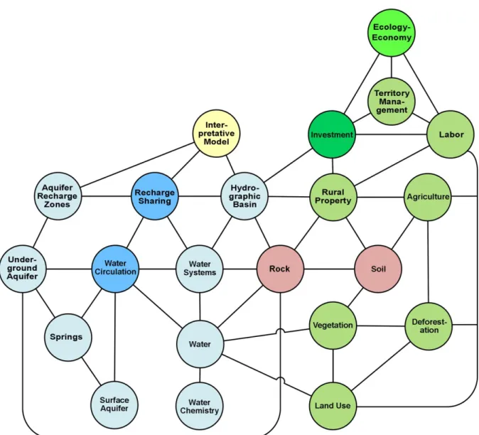
To take advantage of these technical possibilities, Martins Junior (2007)
proposed a new method termed ‘Organograma de Rodas de Correlação e Impactos’ [Wheel Charts for Correlation and Impacts] (ORCI). ORCI is integrated into a web system formerly known as SisORCI and currently referred to as SisARQC. Therefore, the use of ORCI organograms for knowledge architecture may be understood as an innovation of the concept maps method. Figure 2 shows the ORCI developed for the subject of aquifer recharge.
R. Inter. Interdisc. INTERthesis, Florianópolis, v.10, n.2, p. 360-409, Jul./Dez. 2013
Figure 1 – Ontological graph of the structure of the system and subsystems used for aquifer management in a SHriMP reference visualization using the Jambalaya manipulation platform (Storey et al. 2001) and Protégé software. The term aquiperm encompasses aquitards and
Relationships between the color shades of the content wheels and the phenomena encompassed by the ORCI organogram of ARZs:
Tone Related Phenomena
Light blue Water systems
Dark blue Dynamic water processes Pink Rocks and weathering mantle
Light green Processes related to land cover and use
Other green Economic and financial systems
Figure 2 – An ORCI organogram for ARZs. There is no hierarchy in the ORCI organogram. Instead, there are sequential, parallel and simultaneous relationships. The relationships may
be, e.g., conceptual, systemic or pertaining to sensitivity.
R. Inter. Interdisc. INTERthesis, Florianópolis, v.10, n.2, p. 360-409, Jul./Dez. 2013
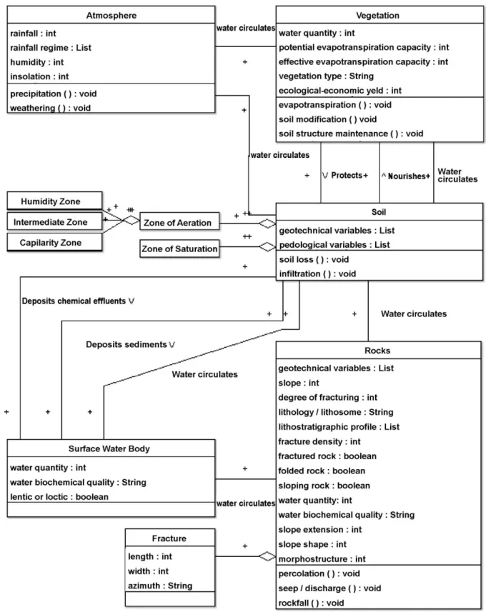
Figure 3 – Context-level UML class diagram. The geological objects (ARZs, aquifer reservoirs and discharge zones) are indicated. Natural and induced processes may alter the energy and mass exchange rates. The safety methods (conservation, optimal soil use, use restrictions,
yields, conservation methods) may be programmed. Symbols: int – numerical information; string – textual information; Boolean – logical information; void – functions the value of which
is to be filled according to the given instances; list – list of variables.
Figure 4 – Context-level UML class diagram, in which the objects and processes are represented according to a view delineated from the environmental systems under consideration. The ORCI organogram (Figure 2) presents itself as a preliminary stage for the
formalization of this diagram.
R. Inter. Interdisc. INTERthesis, Florianópolis, v.10, n.2, p. 360-409, Jul./Dez. 2013
Figure 5 – Context-level activity diagram for environmental management of aquifer recharge. Decision making is aided by considering the limit conditions (preservation area, conservation
area, chemical security, mandatory methods of geotechnical security, reciprocal compatibilities and incompatibilities among the various parameters).
INCORPORATING HYDROGEOLOGY INTO THE PUBLIC POLICIES ON
ENVIRONMENTAL AND WATER RESOURCES
Legal Aspects
The assessment of the possibilities of using knowledge on aquifer recharge and discharge processes in the environmental analyses of public policies requires the characterization of the normative context of such policies. Considering that the instruments used to develop environmental and water resources policies are delimited in a body of legal and infra-legal norms, the dialog between hydrogeology and environmental law becomes vital.
The current Brazilian judiciary system makes few references to the protection of hydrogeological processes. If the norms were to delimit the need for a minimal knowledge on aquifer recharge and discharge in areas of human intervention, the government and the private sector would have to incorporate this topic into their technical work.
The permanent preservation areas (PPAs), which are defined by the Native Vegetation Protection Law (Federal Law nº 12,651, of 2012), offer partial protection to key areas of the hydrogeological cycle. However, this protection is not specific and therefore not easily adapted to different hydrogeological contexts. The Conama (Conselho Nacional de Meio Ambiente [National Council of Environment]) Resolution nº 369 of 2006 (when describing studies needed for environmental intervention in urban PPAs) and certain reference terms for environmental impact assessment (EIA) in karst areas demand the specific consideration of hydrogeological processes. However, the incorporation of this legal provision must be founded on social legitimacy and practicality. Otherwise, its application and enforcement may not be effective. Thus, an interesting strategy is to progress from simple use restriction (not-doing) toward sustainable conditions of land use (how to do).
Based on a comparative analysis of laws in several countries, the primary tool for groundwater protection has been the establishment of areas of well protection. The methods vary from the adoption of a fixed circular perimeter to the calculation of the groundwater flow rate (COELHO; DUARTE, 2003, p. 81-82).
R. Inter. Interdisc. INTERthesis, Florianópolis, v.10, n.2, p. 360-409, Jul./Dez. 2013
groundwater flow area and does not consider differences in the groundwater flow rate (USEPA, 1986, p. 9-12; CARVALHO; HIRATA, 2012). Useful inferences to delimit the protection area may be obtained using the aquifer-pumping test or tridimensional numerical/analytical simulation modeling of the drawdown cone relative to the catchment (COELHO; DUARTE, 2003; CARVALHO; HIRATA, 2012). However, in areas with intense well drilling, the drawdown cones may become interconnected, which demands more complex and larger-scale regional studies (CETESB, 2004).
In Brazil, the sources of mineral water (that is, wells or springs with strict economic value, specifically hydromineral or bottling facilities) require studies for the protection of their recharge areas. These studies are detailed in the DNPM [Departamento Nacional de Produção Mineral (National Department of Mineral Production)] Ordinance nº 231 of 1998. Analogous to the protection perimeters of wells in European countries, this ordinance prescribes the following classification:
Influence Zone (Zona de influência, ZI) – area relative to the drawdown cone (lowering of the potentiometric surface). The ZI is the immediate perimeter of the well or spring, where only activities necessary for catchment
are allowed. The zone’s dimensions are a function of the source’s
hydrogeological characteristics and how vulnerable the source is to short-term contamination.
Transport zone (Zona de transporte, ZT) – area between the recharge area and the catchment site. This zone determines the time required for a contaminant to travel between the recharge zone and the catchment site. This zone is designed to protect against the more persistent contaminants.
Contribution zone (Zona de contribuição, ZC) – recharge area of the catchment site, which is delimited by the flow lines that converge to this point (equivalent to the effective hydrogeological basin).
areas with a distance estimated based on the soil’s hydraulic conductivity, which is
calculated using analyses of granulometric texture.
Regarding these protection perimeters, USEPA (1986, p. 13) notes that the legal criteria for the protection areas of wells are primarily designed to ensure the water quality of the wells and thus take no significant consideration of ecological impacts, relationships of aquifer discharge with the springs downstream, and multiple water and land uses.
Regarding international law, the United Nations’ International Law
Commission has been discussing over the last decade how to improve the international agreements that pertain to underground aquifers (UNITED NATIONS, 2008). This discussion has a special relevance for Brazil in connection with the Guarani Aquifer (spread among Brazil, Argentina, Uruguay and Paraguay). Analogous to the difficulties in managing trans-border international aquifers, in Brazil, there is the additional difficulty of managing trans-border aquifers between different states because the Brazilian Federal Constitution determines that states have autonomy over the groundwater within their territorial limits (art. 26, item I). This case is an example of how the discussions pursued on one scale of approach (international) may be used for management on a different scale (interstate). In both approaches, the impact of soil use on the recharge area within the territory of one political entity may compromise the use of the aquifer by the other political entities.
In Brazil, the federal law has no specific rules for groundwater management. Resolutions no. 15/2001, 22/2002, 76/2007 and 92/2008 of the National Council for Water Resources (Conselho Nacional de Recursos Hídricos - CNRH) state the need to include groundwater in the instruments of the Water Resources Policy. However, the resolutions are general and do not specify specific instruments for groundwater management. Nevertheless, groundwater is addressed by general instruments presented in the water resources national law: hydrographic basin master plans, water resources information systems, permits for water use and charges for water use.
R. Inter. Interdisc. INTERthesis, Florianópolis, v.10, n.2, p. 360-409, Jul./Dez. 2013
hydrogeochemical influences. Therefore, there are uncertainties regarding the scientific knowledge and local assessment of these characteristics, as well as regarding the use and management demands. Analogously, the criteria for the concession and management of permits to use groundwater remain far from understanding the seasonal volume and recharge of the underground aquifers and, to a greater extent, from understanding how the underground water catchments affect the surface water systems.
Since the updating of the Safe Drinking Water Act in 1986, the US government may delimit areas critical to the protection of aquifers based on specific technical studies (USEPA, 1986). The Brazilian Water Resources National Policy has no similar provision. To close this gap in federal legislation, the states of Minas Gerais, São Paulo, Pernambuco, Pará, Goiás, Rio Grande do Sul, Mato Grosso, Mato Grosso do Sul, Distrito Federal, Acre, Paraná, Rio de Janeiro, Piauí, Amazonas, Rondônia, Tocantins and Roraima have issued their own normative instruments to address groundwater protection, all in similar ways, according to a survey by Toscano et al. (2008).
Regarding the recharge of aquifers for public supply (from wells or resurgences), the previously mentioned state legislation provides the possibility to delimit three zone types:
Maximum Protection Area - encompasses in full or in part aquifer recharge areas that are highly vulnerable to pollution and that correspond to groundwater deposits essential for public supply.
Restriction and Control Area - characterized by the necessity to restrict abstraction and by maximum control of established pollution sources and new potentially polluting activities.
Protection Area of Wells and Other Catchments - includes the minimal distance between wells and other catchments and the respective protection perimeter.
Dutra (2005, p. 30) criticizes the term maximum protection area because the adjective maximum, which was adopted from comparative international laws with the meaning of the maximum area of coverage, is commonly misinterpreted as the area of maximum protection in Brazil. In addition, the Protection Areas of Wells and Other
Maximum Protection Areas, analogously to the European system (COELHO;
DUARTE, 2003; UNITED KINGDOM ENVIRONMENTAL PROTECTION AGENCY, 2008, p. 80). For the public, this meaning of “maximum protection area” increases the difficulty of its application, because it does not create the impression that it is possible to reconcile sustainable land use with aquifer protection.
Although a large proportion of these state normative instruments of groundwater protection have been sanctioned in Brazil since the 1990s, they have been little used. In São Paulo state, the use of such an instrument has been formally recorded in two areas: Ribeirão Preto (DAEE [Departamento de Águas e Energia Elétrica (Department of Water and Energy Resources)] Ordinance no. 1.594, October
5, 2005; CRH [Conselho Estadual de Recursos Hídricos (State Council for Water Resources)] Deliberation no. 82, June 18, 2008) and Jurubatuba (SÃO PAULO, 2009).
In both cases, these measures were applied after the emergence of serious social conflicts related to groundwater shortages, both in quality and quality. Therefore, it is expected that with increasing demand for water for different activities (rural, industrial and urban) and the associated expansion of potential pollution sources, the protection instruments based on state policies will receive increased use in other Brazilian regions.
Conservation Units in Aquifer Recharge Zones
In addition to the instruments of the Water and Groundwater Resources Policy, the government has often attempted to protect the recharge of public supply sources by other means, such as using conservation areas. A typical conservation model has been established in Minas Gerais and São Paulo: the spring protection area. In addition, in 1992, Minas Gerais promulgated State Law no 10,793, which provides additional rules for the licensing of enterprises in areas that contribute to springs used for public supply, including those outside conservation areas.
R. Inter. Interdisc. INTERthesis, Florianópolis, v.10, n.2, p. 360-409, Jul./Dez. 2013
society to obey these rules. A more effective implementation of these instruments depends on a strategic view that includes the relations of politics, power, conflicts and social processes (BRASIL, 2001, p. 152).
An interesting approach has been to include segments of the society in the elaboration, implementation and revision stages of the delimitation of restricted use areas. This inclusion has been implemented using deliberative councils with public participation, public hearings, and other direct and indirect means of participative democracy. In regions where land use is more homogeneous, such as those occupied by agricultural activities, the joining of efforts in relation to common interests is simpler and strongly motivates individuals to value the social capital. Conversely, in areas with a larger diversity of social representations, this endeavor may be more complex because of the more fragmented and diffuse interests (BRASIL, 2001, p.153).
Human Resources
Although the technical community increasingly considers hydrogeological analyses in the context of water and environmental management to be vital, these analyses are seldom performed. Among the obstacles to the analysis of hydrogeological processes are limited numbers of trained personnel, financial resources and time. Typically, environmental and water resources agencies have few geologists on staff, which is a barrier to the incorporation of geological knowledge in the execution of the instruments of their respective public policies.
A possible explanation of this problem in Brazil is the insufficient number of professionals in the geology and mining engineering fields available to the mining and mineral prospecting labor market (even in the medium term, according to BRASIL, 2011). In addition, the lack of basic training in hydrogeology of the other professionals in the environmental studies teams hinders the initiation of the dialog to solve the previously mentioned problems.
assigning of new tasks to these professionals is a potential means to ensure minimal quality in areas in which such knowledge is crucial.
However, in a context in which interdisciplinary approaches are sought, restricting the professional background of the relevant employees may diminish the possibilities of dialog and of providing a more ample interpretation of the environmental problems related to aquifer discharge. The issue of the qualifications of different professionals becomes more complex with the increasing creation of new undergraduate- and graduate-level courses that intersect with the interests of the water resources field and geoscience.
One alternative is to use a minimal set of disciplines (knowledge matrix) instead of demanding a specific graduate diploma, as proposed by the 2005 CONFEA [Conselho Federal de Engenharia e Agronomia (Federal Council of Engineering and Agronomy)] Resolution no. 1,010, which was intended to come into force in Brazil in 2012. However, on May 25, 2012, the CONFEA plenary voted to temporarily suspend this resolution, claiming that additional studies and specifications were required.
Methodological Considerations on Aquifer Recharge Study Techniques
Despite the issues regarding the availability of trained professionals to address the hydrogeological aspects of the environmental and water resources public policies, such considerations do not exclude the possibility that the currently available methods of hydrogeological studies are not adequate for the contexts in which they are needed to solve environmental and water use issues. Such inadequacy may be the result of a number of issues, such as [1] initially available data, [2] scale(s) of spatial dimension and detail, [3] available professionals, [4] time and financial resources, [5] the required response and [6] the required degree of certainty.
Doubtless, the development and application contexts in which the various approaches and methods of hydrogeological study have been developed originate in the academic setting or research institutes. In such contexts, research is based on funded projects, each of which requires years of development, supported by teams of
R. Inter. Interdisc. INTERthesis, Florianópolis, v.10, n.2, p. 360-409, Jul./Dez. 2013
in well construction, the drawdown of water tables in mining activities and dam construction.
However, such separation between theoretical and practical development caused Dooge (1988) to recognize the link in the water resources field between a theoretical science (which seeks academic advances in knowledge) and an applied science, which is dedicated to using certain sets of consolidated practices to solve practical problems. Although academic research often focuses on problems with current practical relevance to society, its main goal remains to advance scientific knowledge and to improve the correspondence between models and reality.
Such considerations indicate a need to develop methods to diagnose aquifer recharge and discharge such that their application will be viable in the current context of public policies on environmental and water resources. Such methods may provide key information to aid in decision making based on local instruments (e.g., permits to use water resources, environmental licensing, the allocation of legal preservation areas, deforestation permits) and the development of regional planning (e.g., water resources master plans, municipal master plans, ecological-economic zoning).
Many of the diagnostic and mapping techniques currently applied in environmental and water resources policies exhibit a compartmentalized, static view of the environment. Therefore, groundwater circulation may, by means of aquifer recharge and discharge, reflect the spatio-temporal topological relationships between the elements of the environment, which integrate ecosystems, geosystems and land and water use. Such methodological developments require a good epistemological foundation, with an interdisciplinary focus directed toward water and environmental management.
Strategies to Incorporate Hydrogeological Information in the Public Policies
restrictions must be considered. However, it is largely recognized that the technical possibilities of contaminated soil and aquifer recovery are substantially more costly than restrictive prevention measures (SOUZA, 2010).
Preventive management, such as the identification of areas with increased potential for conflict and areas in which the population is more dependent on the access to groundwater, is another possible strategy. In the US, the government has an institutional policy of identifying priority areas in which the population is more than 50% dependent on the access to groundwater (USEPA, 2005). These regions are subject to special management procedures, including more detailed studies regarding access to surface sources. In the state of Texas, the areas identified as important aquifers by the communities are managed by aquifer councils (FLORES, 2008), similar to the hydrographic basin committees in conventional water resources legislation.
The location of current and potential water sources for public supply has been identified throughout the United Kingdom (UNITED KINGDOM ENVIRONMENTAL PROTECTION AGENCY, 2008). To protect these perimeters, special spring protection areas were delimited in a conceptual manner. In addition, local (case-by-case) analyses are conducted using weighted checklists to determine whether more detailed studies are required for the application of specific management instruments in the recharge areas (UNITED KINGDOM ENVIRONMENTAL PROTECTION AGENCY, 2008).
Because of the high cost of hydrogeological studies, exploratory methods that perform at least a preliminary characterization of the aquifer recharge processes in a given region may provide the initial information that can be used by environmental and water resources agencies, particularly in developing countries. For example, mapping the relative height to the position of springs (RENNÓ; SOARES, 2003), complemented by mapping the relative height to water courses (RENNÓ et al., 2008; NOBRE et al., 2011), may reveal regions with a predominance of aquifer recharge and discharge.
R. Inter. Interdisc. INTERthesis, Florianópolis, v.10, n.2, p. 360-409, Jul./Dez. 2013
subsurface and groundwater flow, while providing direct information on the behavior of the distinct hydrological dynamics of the basin associated with each station (VASCONCELOS et al., 2013).
Regarding the local action instruments, the environmental impact assessment (EIA), the instrument of the National Environmental Policy in Brazil encompasses rapid diagnostic methods (LOHANI et al., 1997). Rapid diagnostic methods, which are frequently used in environmental impact assessments in riparian ecosystems (BARBOUR et al., 1999; CALLISTO et al., 2002; RODRIGUES, 2008), consist of a set of easily and swiftly applied field procedures and structured spreadsheets. The adaptation of these methods to assess aquifer recharge appears to be an interesting tool for learning and for field application by environmental and water resources professionals (VASCONCELOS et al., 2012b).
With the gradual implementation in Brazil of databases and decision-making support systems in the water resources management agencies, the data related to the permits to use groundwater becomes an important source of information regarding aquifers and their use. One example is SIAGAS (Groundwater Information System – Sistema de Informações de Águas Subterrânea), which contains information on the lithological profiles, hydrogeochemical data and pumping tests of wells with permits granted throughout Brazil (NASCIMENTO et al., 2008).
Notwithstanding SIAGAS’s unquestionable usefulness for groundwater
management, the statement by Gomes (2008) continues to apply: the use of these data is extremely limited for the modeling of the aquifers to which they refer. After all, these wells were located in areas in which they would have maximum efficiency
according to the driller’s knowledge and based on field information that is not noted in
regional-scale maps (i.e., the wells are not spatially random). In addition, the wells are not homogeneous with respect to depth and other construction characteristics, which increases the difficulty of comparisons and spatial interpolations.
FINAL CONSIDERATIONS
The environmental analyses of aquifer recharge and discharge have demonstrated that this area of research can be a fruitful interdisciplinary field, both for scientific development and for the sustainable management of water and land use. The transdisciplinary dialog presents a number of challenges. However, it promises improved understanding and maturity in the various scientific communities involved. This paper attempted to clarify the relationships between the existing disciplinary knowledge bases and to indicate the potential of new pathways for this interdisciplinary research. Nevertheless, it is recognized that we remain far from achieving a concise and integrated theoretical base that would effectively encompass the knowledge and action dynamics related to the underground aquifers.
The application of computational modeling, as presented in this paper, may be useful for the development of computational models and specialized diagnostic and decision-making support systems for aquifer management. In future studies, a promising way of modeling would involve the creation of more detailed diagrams, while aiming to integrate decision-making support systems and geographic information systems (GIS). This integration may be performed with the aid of the theoretical propositions on geo-ontologies (FONSECA et al., 2000; FONSECA et al., 2006; WANG et al., 2008; among other works), which would connect the existing discussions on the representation, structuring, treatment and management of expert geoscience information. In addition, using the diagrams shown in Figures 3 and 4, future studies could analyze which classes and treatments deserve the joint treatment of temporal and spatial dynamics (DIAS et al., 2005).
This paper demonstrated that the incorporation of hydrogeological processes into the environmental and water resources policy demands, first of all, that this area of knowledge (hydrogeology) be able to show that it possesses practical methods to solve the environmental issues in question. This demonstration involves the development of methods adapted to the application context and the capacity to transmit and teach this knowledge to professionals from other fields.
R. Inter. Interdisc. INTERthesis, Florianópolis, v.10, n.2, p. 360-409, Jul./Dez. 2013
the application of financial resources with the agility necessary to solve the problems faced. Therefore, the development of methods that can be applied in environmental and water resources management must consider the limitations on time, human resources, information sources and legal possibilities inherent to their respective application contexts.
RECARGA DE AQUÍFEROS: EPISTEMOLOGIA E INTERDISCIPLINARIDADE
Resumo:
As questões ambientais envolvendo recarga e descarga de aquíferos apresentam-se como um desafio para a interdisciplinaridade. Empreende-se, neste artigo, um estudo epistemológico da contribuição de diversas áreas de conhecimento à pesquisa dos processos hidrogeológicos. Apresenta-se, como hipótese, que esse diálogo acena a desenvolvimentos imprescindíveis para a resolução dos problemas ambientais e de uso da água contemporâneos e vindouros. Destarte, propõe-se discutir perspectivas epistemológicas e de gestão de informações que possam contribuir para a melhor caracterização espacial, qualitativa e quantitativa da recarga de aquíferos. São elaboradas modelagens conceituais preliminares demonstrando as possibilidades de articulação interdisciplinar para resolução dos desafios ambientais apresentados. Por fim, são discutidas as possibilidades de incorporação do conhecimento sobre recarga de aquíferos nas políticas públicas de meio ambiente e recursos hídricos.
Palavras-Chave: Aquíferos. Hidrogeologia. Epistemologia. Meio Ambiente. Interdisciplinaridade
RECARGA DE ACUÍFEROS: EPISTEMOLOGÍA E INTERDISCIPLINARIDAD
Resumen:
Los temas ambientales relacionados con la recarga y la descarga de acuíferos presentan-se como un desafío interdisciplinario. En este estudio, propone-se una investigación epistemológica acerca de la contribución de las diversas áreas de conocimiento aplicadas a la pesquisa de los procesos hidrogeológicos. Presenta-se, como hipótesis, que esto diálogo señala a desarrollos imprescindibles para la resolución dos problemas ambientales e del uso del agua no presente e en lo futuro. Por lo tanto, propone-se discutir perspectivas epistemológicas y de gestión ambiental que contribuyan para una mejor caracterización espacial, cualitativa y cuantitativa, de la recarga de los acuíferos. Son elaborados modelos conceptuales preliminares demostrando las posibilidades de articulación interdisciplinaria para la resolución de los problemas ambientales presentados. Por último, se discute la posibilidad de incorporar el conocimiento acerca de la recarga de los acuíferos por las políticas públicas de medio ambiente y recursos hídricos.