Earth mortars from pre-historic
habitat
settlements in south Portugal
Case studies
Patrícia Bruno
UNIARQ/ University of Lisbon, Portugal
Paulina Faria
Polytechnical Institute of Setúbal, Portugal
António Candeias
Hércules Center/ University of Évora, Portugal
José Mirão
Hércules Center/ University of Évora, Portugal
ABSTRACT:
Analyzing earth mortars from five archaeological habitat settlements in south Portugal allowed deepen the knowledge of some pre-historic building techniques and also contributed to the interpretation and reconstitution of those sites domestic structures.
The analysed materials were composed by different types of earth traces: small clayish daub fragments coming from the renderings of two neolithic pits, from Defesa de Cima 2 (Évora); fragments of clayish mortars with branches prints, coming from covering and filling wood structures, from calcolithic settlement of São Pedro (Redondo, Évora); manual and perhaps moulded mudbricks, probably belonging to a wall adjacent to a surrounding moat, from calcolithic settlement of Alto do Outeiro (Beja); big fragments of a hut wall, probably made of stacked earth, from Alcalar calcolithic settlement (Portimão, Faro).
Earth materials were burnt by fire, which permitted their conservation until nowadays.
1. Introduction
The present article is based on the final results of a research project which had the main objective of deepen the knowledge on earth constructive use on pre-historic domestic structures.
Starting from the analysis of structures traces that existed in a considered set of archaeological sites in south Portugal, allowed characterizing pre-historic domestic architectures, attending to aspects like shape, typology, construction techniques and building materials.
Regarding earth constructive use, different building techniques were identified: - Molded earth, used on walls;
- Stacked earth, used on walls;
- Earth mortars covering and filling vegetable structures; - Earth mortars binding stone masonry;
- Earth mortars rendering pits; - Mudbricks masonry.
The most antique techniques seem to be molded earth and earth mortars rendering pits, and they were identified since Ancient Neolithic; the first one, apparently used on the construction of culinary ovens and the second, rendering underground storage bins. The other techniques were all identified since Calcolithic Period, but, apparently, only earth mortars binding stone masonry and covering and filling vegetable structures seem to be used on Bronze Age domestic structures (Bruno, 2007).
Case studies provided a larger vision of some of those building techniques, contributing to the interpretation and reconstitution of the analyzed structures.
fragments of clayish mortars with branch prints, coming from covering and filling of wood structures, from calcolithic settlement of São Pedro (Redondo, Évora); manual and perhaps moulded mudbricks, probably belonging to a wall adjacent to a surrounding moat, from calcolithic settlement of Alto do Outeiro (Beja); big fragments of a hut wall, probably made of stacked earth, from Alcalar calcolithic settlement (Portimão, Faro).
All materials were burnt by fire, which permitted their conservation until nowadays.
2. Territory
The studied area sets in the south of the current Portuguese territory and is limited north by Tagus river, east by Spain border, west and south by the Atlantic Ocean.
Plain landscapes are dominant, mostly less than 400 m, with punctual elevations. Geologically, the territory is generically characterized by the presence of metamorphic and eruptive rocks from Hesperic Massive (in interior Alentejo) and sedimentary accumulations (in littoral areas and Sado and Tagus basins) (Ribeiro, 1945). Tagus, Sado and Guadiana are the main rivers of the region.
Climate is typically Mediterranean, with high temperatures, strong insulations and absence of rain on summer. In the Atlantic coast, relative humidity is higher and temperature moderate than in interior Alentejo. The warm and luminous weather goes until the autumn, despite temperature coolness and the occurrence of some rain. Generally, rain falls strongly from December to March (ibid.)
Plant life, conditioned by climate, is mainly composed by Mediterranean species: trees and bushes of green leafs like cork trees, holm oaks, pine trees (specially stone pines), arbutus trees, heathers, laurels, lentisks, butcher’s brooms, oleanders, canes, rock roses; aromatic plants from dry soils like rosemary, lavender and thyme; planted trees and bushes like almond trees, fig trees, carob shrubs, orange trees, olive trees and vineyards (ibid.).
3. Case studies 3.1. Methodology
Generally, analyzed samples were selected from units containing materials stratigraphically related with domestic structures traces, like pits, hut bottoms, wall bases or post holes. Morphological diversity of samples was also considered as a preponderant factor, in order to characterize building systems.
Beyond mortars composition study, in some of the cases, possible relations between mortar fragments and associated structures were establish, in order to formulate some hypotheses about building systems and trying to reconstitute architectures.
Methodology used on materials analyses from case studies included, in a first stage, visual observation and describing samples by measurement, drawing and photo register; later, some of those samples were observed with binocular glass and subject to granulometric and mineralogical analysis.
3.2. Defesa de Cima 2
- Location and
archaeological interventionAncient neolithic habitat of Defesa de Cima 2 was located in Torre de Coelheiros, Évora. Geologically, occupation was implanted over an eruptive rocks substrate, mostly composed by granitic quartzodiorites and granodiorites not porphyritics. Soils are mediterranean brown, of quartzodiorites and granodiorites (SROA, 1967).
Archaeological intervention provided a large set of anthropic origin pits, excavated in the geological substrate, apparently used has storage bins.
fully sedentary (Santos & Carvalho, 2008). Burning interior renderings would provide preservation of stored products, by protecting them from the soil humidity.
- Analysis of materials
Analyzed samples were composed by small plaques of clay mortars, with 2.0-3.0 cm of thickness, collected from pit 5 and pit 16 renderings.
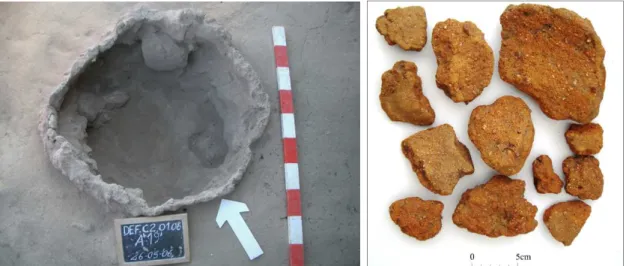
Pit 5 (figure 1) had circular plan, with 0.80 m of diameter and 0.83 m of maximum preserved depth; inside, close to the basis, contained imbricate stones with combustion vestiges. Clayish renderings were continuous, surfacing the pit’s lateral walls.
Pit 16 was too much destroyed. It had circular plan, with 0.80 m of diameter and 0.50 m of maximum preserved depth. Only part of lateral renders was preserved.
Morphologically, all samples were composed by small nodules and plaques of various dimensions, with 3.0 cm of maximum thickness (figure 2). Concave faces of the plaques were smoothed and some of them had finger prints.
Mortars had brown-reddish colors and homogeneous compositions. There were not detected different layers on the renderings, negative traces of organic materials, animal or vegetable fibers.
At binocular glass, little porous were observed, with diameters until 1.0 mm; microfissures were also rare, with apertures until 0.2 mm.
Disaggregating samples to granulometric analyses was quite easy. Fragments interior was almost raw, showing different degree of burning.
Granulometric analyses (Table 1) showed similar compositions for both samples: fine aggregates were dominant (84.55% e 85.74% of sands in samples from pit 5 and pit 16, respectively), followed by ligands portions (8.2% and 12.5% of silt and clay, in samples from pit 5 and pit 16, respectively) and, lesser extent, large aggregates (7.25% and 1.26% of pebbles, in samples from pit 5 and pit 16, respectively).
Table 2 presents X ray diffractometry analysis, made to samples from pits 5 and 16.
Figures 1 and 2 – Defesa de Cima 2: left, pit 5 after excavation (photo: Arqueohoje); right, samples from pit 5 rendering
Table 1 - Defesa de Cima 2: granulometries from pit’s 5 and 16 renderings
Fraction Ø (mm) % - pit 5 % - pit 16
Large pebbles 60-20 0 0
Medium pebbles 20-6 0 0.21
Small pebbles 6-2 7.25 1.55
Coarse sand 2-0.6 21.70 25.69
Medium sand 0.6-0.2 50.60 41.05
Fine Sand 0.2-0.06 12.25 19.00
Table 2 - Defesa de Cima 2: mineralogical composition of pit’5 and 16 renderings
Compounds identified pit 5 pit16
OF FF OF FF
Quartz ++ ++++ ++++ ++++
Anortoclase - ++ + -
Plagioclase (albite) +++ - ++ ++
Amphibole (Riebeckite) tr + tr +
Zircon - + - -
Illite ++ ++ - +++
OF – overall fraction FF – fine fraction
++++ - predominant compound +++ - relatively high proportion ++ - average proportion + - low proportion tr - traces - - not detected
- Analysis of results
Obtained results showed that samples compositions have typical characteristic features of clay rendering mortars:
- Regarding granulometry, both samples showed low quantities of larger aggregates, with predominance of fine elements (specially sands) and good proportions of ligands, which is also essential for adhesion to the substrate in any rendering mortar;
- Samples minerologies were also very similar, essentially composed by siliceous elements and good proportions of clayish minerals (illite, in this case, probably from chemical modification of eruptive mica), which is a characteristic feature in clay rendering mortars.
Moreover, aggregates mineralogy suggests the use sands derived from chemical modification of eruptive rocks (quartz, feldspar and amphiboles), which is consentaneous with the local geology.
3.3. São Pedro
- Location and
archaeological interventionCalcolithic settlement of São Pedro (figure 3) was located in Redondo (Évora), occupying the top and the strands of a hill at the Northeast current area of the village, with wide visual field of the landscape.
Geologically, the area falls in Redondo/ Ossa anti-form. Shale rocks are predominant in the archaeological site. Surrounding, granitic rocks are also presents – granodiorits and quartzodiorits, mostly (SPG, 1986). Local soils are mediterranean brown (SROA, 1964).
Archaeological interventions between 2004 and 2009 allowed identifying a fortified settlement, with occupations dating the 4th and 3rd millennium b.C., developed on five differenced phases.
During excavations, many traces of dwellings were found, specially belonging to the 3rd and 5th
phase.
Most of the analyzed materials – fragments of clay mortars with branches prints – were collected from 3rd phase stratigraphic units. Unfortunately, it was not possible to clearly relate
them with any of the identified structures.
The 3rd phase corresponded to the abandonment and dismantling of defensive structures from
2nd phase and, apparently, was characterized by an open occupation, mostly composed by
Figure 3 – São Pedro: general view of the excavated area, taken from North (photo: Rui Mataloto)
- Analysis of materials
Analyzed materials were chosen from units that contained fragments of clay mortars with branches prints, considering the following aspects:
- Samples dimensions;
- Branches or other prints, possibly related with support structures elements; - Final surfaces evidences, smoothed or decorated.
Unit 0 was the one that provide the larger quantity of fragments with branches prints and smoothed surfaces. So, and despite the problems to associate these materials to underlying structures, it was decided to register some of this unit samples.
Many of the fragments showed branches prints and, simultaneously, on their opposite face, smoothed surfaces, some of them with finger prints. Those final surfaces had plain, concave and convex forms.
As to dimensions, fragments had maximum thickness of 3.4-6 cm and distances between branches and smoothed surfaces about 1.2 cm to 1.9 cm. Branches had parallel, perpendicular and oblique directions between them, measuring 0.3 cm to 1.8 cm.
Figures 4 and 5 – São Pedro: samples SP-11 and SP-12
Sample SP-12 (figure 5) also showed three smoothed surfaces, two of them forming corner, with an open angle of about 140º. One of those faces may probably correspond to a wall.
Both samples had finger prints in their smoothed faces.
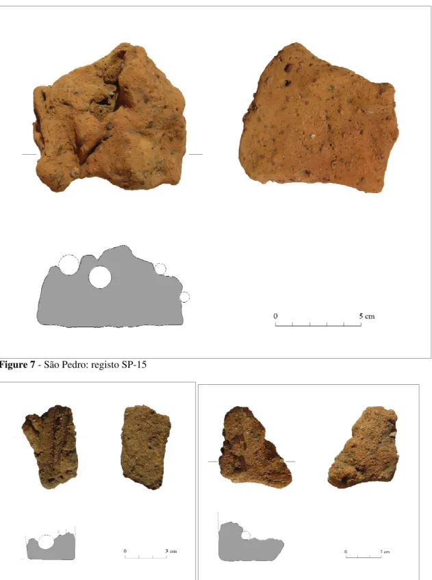
Sample SP-13 (figure 6), showed several parallel and perpendicular branches prints. This sample registered the higher thickness of all the set (6.0 cm). In the face with branches prints, a very fine branch, like a thread followed the bands of the larger branches, suggesting that branches were bound by that element.
Figure 6 - São Pedro: sample SP-13
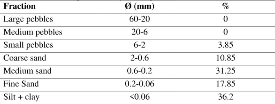
Materials from unit 476 were collected in the North strand of São Pedro and were probably related with a circular plan hut from the 5th phase.
However, materials were majority composed by small deformed nodules, without branches prints.
From this set, only dethatched sample SP-15 (figure 7), which had several parallel branches, with diameters between 0.5 cm and 1.5 cm. One of them conserved the integral negative section, which proves that, contrary of what was thought, combustion not always causes the total fracture of coating layers in contact with branches (Bruno, 2006).
Unit 644 was located in the South strand of the hill, partially under part of a wall from the 2nd
phase and a stone layer from the drop of a probable structure. Once again, it was not possible to associate clay fragments with any structure.
Samples maximum thickness measured about 2.0-8.0 cm. Distances between surfaces with branches prints and smoothed surfaces were about 0.9-2.6 cm.
Branches had circular and oval sections, with diameters of 0.5 cm to 1.5 cm and had parallel, perpendicular and oblique orientations between them.
Figure 7 - São Pedro: registo SP-15
Figures 8 and 9 – São Pedro: samples SP-19 and SP-20
Materials from units 661, 804 and 887 had few branches prints. These units located at the East strand of the site, and it was not possible to relate clay fragments with any structure.
Figure 10 – São Pedro: sample SP-27
Laboratorial analyses were made with fragments from unit 644, which was the one that provided the greatest quantity of materials.
Binocular glass observation showed that mortars were extremely homogeneous and had red ocher colors. Mortars had brown-reddish colors and homogeneous compositions. There were not detected different layers on the renderings, negative traces of organic materials, animal or vegetable fibers.
Mortars had few porous, with diameters until 1 mm; microfissures were also rare, with apertures until 0.1 mm.
Samples disaggregation for analyses was extremely difficult, due to the intense combustion they suffered.
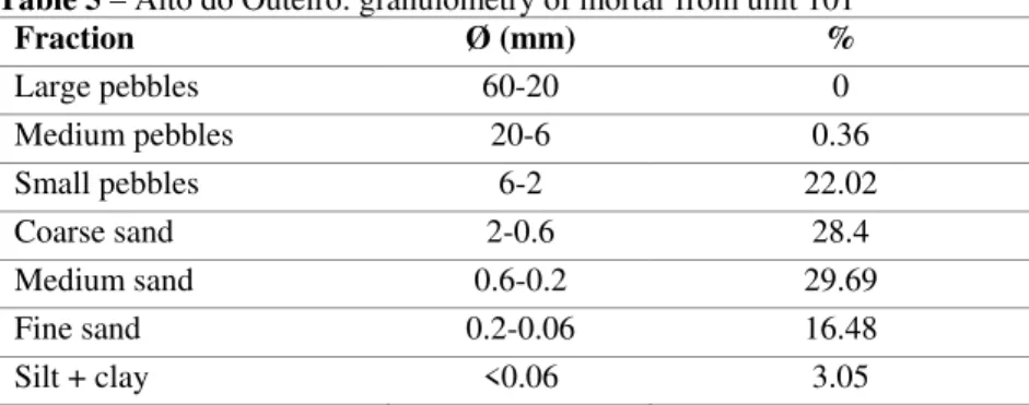
Granulometric analyses (Table 3) showed that mortar was majority composed by fine aggregates (59.95% of sands), 36.2% of ligands and only 3.85% of pebbles.
Table 4 presents X ray diffractometry analysis, made to a sample from unit 644.
Table 3 – São Pedro: granulometry of sample from unit 644
Fraction Ø (mm) %
Large pebbles 60-20 0
Medium pebbles 20-6 0
Small pebbles 6-2 3.85
Coarse sand 2-0.6 10.85
Medium sand 0.6-0.2 31.25
Fine Sand 0.2-0.06 17.85
Table 4 – São Pedro: mineralogical composition of sample from unit 644
Compounds identified OF FF
Quartz ++++ ++++
Muscovite + +
Illite + +
OF – overall fraction FF – fine fraction
++++ - predominant compound +++ - relatively high proportion ++ - average proportion + - low proportion tr - traces - - not detected
- Analysis of results
Obtained results showed that samples compositions have typical characteristic features of clay rendering mortars, essentially composed by fine aggregates (sands) and with a high proportion of ligands.
Identified minerals suggest the use of local soils, particularly quartzite and muscovite sands and illitic clays.
3.4. Alto do Outeiro
- Location and
archaeological interventionCalcolithic settlement of Alto do Outeiro was located in Baleizão, Beja. Occupying the top of a small altitude hill, the site possessed, however, a prominent deployment, in the peneplain surrounding landscape.
Geologically, the settlement area falls in the Beja gabbros region, were dioritic-gabbro rocks are dominant. In the closest surrounding area are also present quartz-diorites, porphyry, conglomerates, sandstones, marls with calcareous concretions, clays, gravels, limestone terraces and tufts. Soils are included in “Beja clays” region, with caulinitic and montmorilonitic clays (SGP, 1992b; Oliveira, 1992).
The settlement was identified and excavated in 2005, due to irrigation system works in the area. Archaeological intervention revealed the existence of a pre-historic habitat surrounded by three undulating moats, possibly supplemented by mudbrick masonry walls.
Large quantities of fragmented mudbricks were detected upon the clogging levels of the most exterior moat (figure 11) and an adjacent stone base, with about 0.5 m of thickness. Those mudbricks, apparently coming from structure decay, probably belonged to a wall upon that stone base.
Excavations and geomagnetic prospection also allowed detecting a large set of underground storage bins, mostly located in the top of the hill, and a water tank, linked by a channel to the most exterior moat (Grilo, 2008).
- Analysis of materials
Chosen materials were selected from two different clogging levels (units 90 and 101), which one containing big fragments and deform nodules of clay mortars from mudbricks.
Materials from unit 90 were composed by several nodules of clay mortar reddish color and a big mudbrick fragment (sample AO-706, figure 12).
The four surfaces of the mudbrick fragment were plain, with straight edges, which suggest the use, on his manufacturing, of some kind of mold.
One of the faces (the smallest) showed two finger prints, which seemed to result from the mudbrick handling while he was still in plastic state. The fragment weighed 2.832 kg and measured 17 cm x 14 cm x 6.5 cm, showing two fractured faces.
Figures 11 and 12 – Alto do Outeiro: left, clogging levels of the exterior moat, were mudbrick fragments were found (photo: Carolina Grilo); right, fragment of mudbrick AO-706, from unit 90
Figure 13 – Alto do Outeiro: fragment of mudbrick AO-729, from unit 101
Several samples taken from de nodules and two samples taken from each mudbrick were observed with binocular glass. As observations showed that materials from unit 90 had many differences, laboratorial analyses were only made with samples from unit 101, clearly similar to mudbrick 729.
Samples disaggregation for analyses was quite easy because, on the inside, fragments were not burnt.
Table 5 – Alto do Outeiro: granulometry of mortar from unit 101
Fraction Ø (mm) %
Large pebbles 60-20 0
Medium pebbles 20-6 0.36
Small pebbles 6-2 22.02
Coarse sand 2-0.6 28.4
Medium sand 0.6-0.2 29.69
Fine sand 0.2-0.06 16.48
Silt + clay <0.06 3.05
Table 6 – Alto do Outeiro: mineralogical composition of a sample from unit 101
Compounds identified OF FF
Quartz + +++
Plagioclase (albite) ++++ ++++
Amphibole (Riebeckite) + -
Iron ores (chamosite, hematite) tr tr
Illite - tr
Montmorillonite - tr
Calcite ++++ ++++
OF – overall fraction FF – fine fraction
++++ - predominant compound +++ - relatively high proportion ++ - average proportion + - low proportion tr - traces - - not detected
- Analysis of results
Mortars from analyzed samples were mostly composed by fine aggregates, some pebbles and low percentage of silt and clay. Such small quantity of ligands is, however, unusual on mudbrick mortars (Dethier, 1986; Guillaud & Houben, 1989); perhaps for this reason vegetable fibbers were not added to the moisture (a frequent procedure on mudbrick moistures, to control clay retraction after drying).
Still, calcium carbonate (calcite) acted in the moisture as ligand, contributing to stabilize materials and, at the same time, to increase mudbricks exterior surfaces resistance; perhaps for this reason these mudbricks, almost raw, survived until nowadays.
Calcite presence in mudbricks from Alto do Outeiro suggests the utilization of local soils, which contain calcium carbonate resulting from their genesis (Cardoso, 1965).
Aggregates mineralogy also suggests the utilization of sands with common compounds to gabbros and diorites – plagioclases, iron ores (amphiboles) and quartzes – which suggests that they were extracted from local soils; montmorillonite presence (clay mineral which usually derives from basic rocks, gabbros and diorites), associated to illite, reinforces this hypothesis (Ibid.).
Examples of mudbricks composed by large quantities of calcium carbonate (also in the form of nodules of calcite) were found in several neolithic settlements of the Rift Valley, in Jordan, in Çatalhoyuk (Turkey) and in the minoan settlement of Palaikastro (Crete, Greece), in alignment with local soils (Politis, 1993; Doherty, 2007; Jerome, 1993).
3.5. Alcalar
- Location and
archaeological interventionAlcalar calcolithic archaeological set is located in Algarve, between Alvor estuary and Monchique mountain, near the village of Mexilhoeira Grande, Portimão.
The habitat area sets south of the monumental necropolis, in a prominent hill with broad visual control of the surrounding. It occupied an area of about 10 ha, surrounded by a set of moats possibly complemented by walls
(Morán, 2001).
Geologically, the settlement locates in Algarve Barrocal, were sedimentary rocks predominate. The area corresponding to the village is based on a formation of limestones, sandstones and marl-limestones (SGP, 1992a). Soils are mediterranean red or yellow, of limestones or dolomias (SROA, 1959).
Besides surrounding moats, excavations and geomagnetic prospection in Alcalar allowed discovering several domestic structures, mostly composed by hut bottoms, combustion structures and storage bins (Morán, 2001).
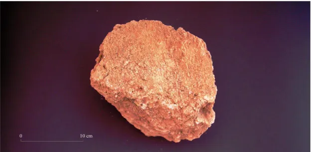
Analyzed materials were collected from a drop inside a big hut with oval plan (figure 14), located in the settlement’s central area. They were found upon the hut’s large stone base and in its interior and probably belong to a massive earth wall. In the hut’s interior existed a fire place, with circular plan on torus form, made on small pebbles and clay mortar, clay rendered.
Figure 15 – Alcalar: sample ALC5-10
- Analysis of materials
Chosen materials were selected from the drop inside the hut (unit 698), which was composed on about 1 m3 of big fragments of earth mortar, orange color, without branches traces.
Generally, selected samples (figure 15) showed irregular textures and seemed apparently rich in fine aggregates (sands), with some pebbles of larger dimensions (limestones and shells), comparing to other analyzed materials; almost all fragments showed carbonated aspect, possibly caused by chemical modification of aggregates.
Many samples showed a smoothed face, sometimes with finger prints.
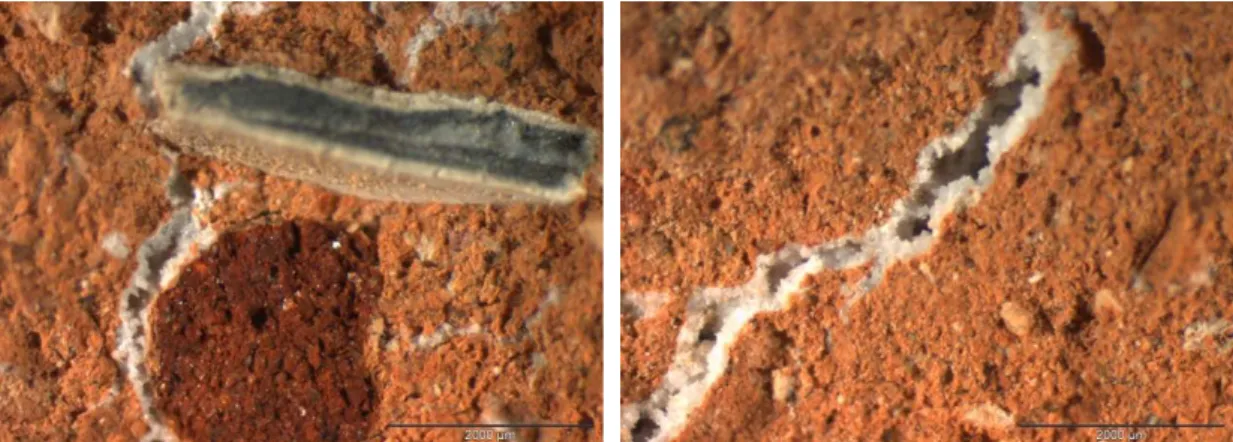
Binocular glass observation (figures 16 and 17) showed that mortars had larger quantities of aggregates than other analyzed materials and also more heterogenic compositions. There were not detected traces of organic materials, vegetable or animal fibers.
Mortars had some circular and oval porous, with diameters until 0.5 mm.
As to conservation status, materials showed chemical modification, by generalized presence of calcareous concretions, probably due to water percolation in the interior of materials. Those concretions were majority associated to large and numerous cracks.
Disaggregating materials to granulometric analyses was extremely difficult, due to its calcification.
Figures 16 and 17 – Alcalar: binocular glass photos of two mortar samples, 20x amplified
Granulometry results (Table 7) showed that mortar was predominantly composed by fine aggregates (65.34 % of sands), followed by pebbles (32.86%), and, in less quantity, by ligands (only 1.8% of silt and clay).
Table 8 presents X ray diffractometry analysis, also made to a sample from unit 698.
Table 7 – Alcalar: granulometry from sample ALC5-07, unit 698
Fraction Ø (mm) %
Large pebbles 60-20 0
Medium pebbles 20-6 0.4
Small pebbles 6-2 32.46
Coarse sand 2-0.6 20.14
Medium sand 0.6-0.2 24.38
Fine sand 0.2-0.06 20.82
Table 8 – Alcalar: mineralogical composition of a sample from unit 698
Compounds identified OF FF
Quartz +++ ++++
Hematite ++ -
Illite + -
Calcite ++++ ++++
OF – overall fraction FF – fine fraction
++++ - predominant compound +++ - relatively high proportion ++ - average proportion + - low proportion tr - traces - - not detected
- Analysis of results
Analyzed mortar was majority composed by fine aggregates, with good proportion of pebbles and low quantities of silt and clay, which is, somewhat understandable, taking into account the construction technique used.
On the other hand, it is possible that on granulometric analyze ligand fraction was obtain by default; in other words, some ligands may have been "glued" to aggregates.
However, and like the previously analyzed materials (fragments of mudbricks from Alto do Outeiro), also here the presence of large quantities of calcium carbonate acted on the moisture as ligand, contributing to stabilize and increase the mortar resistance.
Regarding mineralogical composition, results are consentaneous with local geology, characterized by the presence of limestones, sandstones and marl-limestones; the presence of quartz, calcium carbonate, hematite and illite also suggests the utilization of local soils.
3.6. Rocha do Vigio 2
- Location and
archaeological interventionFinal Bronze Age habitat of Rocha do Vigio2 located in Campinho (Reguengos de Monsaraz, Évora), implanted on a small platform of a rocky spur, on the right bank of Álamo.
Regarding geology, this is an area of silurian formation of metamorphic rocks, were clayish shale dominate (SGP, 1976). Soils are
mediterraneum yellow and brown, of shales (SROA, 1965).
Excavation allowed identifying the traces of an oval plan hut (figure 18), composed by a stone base and a row of slabs of shale, vertical arranged, which defined its exterior perimeter (Calado, Mataloto & Rocha, 2002).
In the interior of that structure were found abundant fragments of clay mortars with branches prints, probably belonging to the walls and roof of the hut, composed by wood structures.
- Analysis of materials
Selection of samples took account, like in São Pedro case, parameters like fragments dimensions, presence of branches prints and the existence of smoothed surfaces. Chosen materials came from units 39, 59, 64 and 67, located in the presumable central area of the hut. Materials from unit 39 seem to have, on visual observation, different compositions. Some of the fragments showed straw traces, apparently added to earth moistures. Generally, all smoothed faces were plain or concaves.
Two samples were drawn: individual records 445 and 1031.
Individual record 445 (figure 19) had 5.6 cm of thickness. The fragment showed a concave smoothed face and, on the opposite site, an irregular surface, with a branch trace with about 3.6 com of diameter; one of the lateral faces had a small branch trace, with 0.5 cm diameter, perpendicular to the larger branch.
Individual record 1031 (fig. 20) had only one branch, with 4.0 cm of diameter. Alongside this, the fragment showed a shaped surface, that seems to have made the frame finish of a jamb or lintel of a doorway.
Figures 19 e 20 – Rocha do Vigio 2: individual records 445 and 1031
Unit 59 presented the largest number of fragments. Manny of them showed smoothed surfaces with finger prints, always planes and concaves.
Branches prints, always opposite to the smoothed ones, measured 0.2-4.0 cm of diameter. Many fine branches prints appeared, apparently from reed. All samples showed straw prints, incorporated into earth moistures.
Individual record 1103 (figure 21) measured 4.7 cm of thickness. It showed a plank and four branch prints. The plank measured 5.0 cm of width and branches 1.0-3.7 cm of diameter.
All materials from unit 64
showed straw prints, incorporated into earth moistures. A good part of fragments also showed reed traces.Fragments with smoothed faces showed finger prints and all of them had plane and concave shapes.
Figure 21 – Rocha do Vigio 2: individual record 1103
Figure 22 - Rocha do Vigio 2: individual record 975
All materials from unit 67
showed straw prints, incorporated into earth moistures. Fragments with smoothed faces showed finger prints and all of them had plane and concave shapes.Branch prints had diameters between 0.5-5.5 cm. Some fragments had planks prints. Three samples were drawn: individual record 901 and samples RV-14 e RV-15.
Individual record 901 (figure 23) had about 4 cm of thickness. It showed a smoothed face, with finger prints; in the opposite face had two branch prints, with diameters of about 1.8 and 2.9 cm, and two planks, all parallels.
Figure 23 – Rocha do Vigio 2: individual record 901
Figures 24 and 25 – Rocha do Vigio 2: samples RV-14 and RV-15
Sample RV-15 (figure 25) measured 4 cm of thickness. It showed a smoothed face, with finger prints, and five parallel branch prints in the opposite face, with diameters of 0.7-1.5 cm. also had two plank prints, apparently parallels to the branches.
Two samples from unit 59 were observed at binocular glass (figure 26).
Disaggregating samples to granulometric analyze was quite easy because, on the inside, fragments were not badly burnt.
Granulometric analyze results (table 9) showed a composition very rich on fine aggregates (70.55% of sands), followed by small pebbles fraction, with 12.9%, and, on less quantity, of ligands (8.55% of silt and clay).
Table 10 presents X ray diffractometry analysis, also made to a sample from unit 59.
Table 9 – Rocha do Vigio 2: granulometry of a sample from unit 59
Fraction Ø (mm) %
Large pebbles 60-20 0
Medium pebbles 20-6 0
Small pebbles 6-2 12.9
Coarse sand 2-0.6 32.5
Medium sand 0.6-0.2 30.35
Fine sand 0.2-0.06 15.7
Silt + clay <0.06 8.55
Table 10 – Rocha do Vigio 2: mineralogical composition of a sample from unit U.E. 59
Compounds identified OF FF
Quartz ++++ ++++
Muscovite + +
Illite + +
OF – overall fraction FF – fine fraction
++++ - predominant compound +++ - relatively high proportion ++ - average proportion + - low proportion tr - traces - - not detected
- Analysis of results
Analyzed samples shown that mortar composition had a low quantity of large aggregates, predominance of fine elements (sand), and a good proportion of ligands, which is characteristic of a plaster finish.
Minerals nature suggests the utilization of quartzite and muscovite sands and illitic clays, which is consentaneous with local geology.
3.7. Commentaries to results
Analysis results suggest, in all cases, that mortars were produced with local materials.
Generally, samples morphologies and compositions revealed consistent with the probable building techniques – mortars exclusively use on renderings showed the lowest percentages of pebbles (Defesa de Cima 2); rendering and filling mortars (Defesa de Cima 2, São Pedro, Rocha do Vigio 2) showed highest percentages of clay than de others, used on the construction of monolithic structures (Alcalar) or mudbrick masonry (Alto do Outeiro).
In Alcalar case, which building technique was apparently monolithic earth, mortar had less quantity of ligands and higher percentage of large aggregates (pebbles, gravel and seashells), similarly to moistures frequently used on the construction of massive walls, such as those of rammed earth. However, it seems that there were not used moulds on Alcalar hut walls construction.
To clarify stays why having good clayish soils, constructers from Alcalar and Alto do Outeiro choose others, with such low quantities of clay and rich in calcium carbonate. Perhaps they knew that calcium carbonate could act as ligand, and be used it to produce more resistant moistures, almost similar to the ones that, on future times, would be called “lime mortars”.
References
Bruno, P. (2006). O uso da terra na construção de uma cabana do Bronze final. Estudo dos materiais provenientes do sítio proto-histórico Rocha do Vigio 2 (Campinho, Reguengos de Monsaraz). Terra:
forma de construir. Arquitectura-Antropologia-Arqueologia. Lisboa: Argumentum, p. 67-73
Bruno, P. (2007). Arquitectura de terra na Pré-história – vestígios de estruturas habitacionais, do VI ao II milénio a.C., no Sul de Portugal. Terra em Seminário 2007 – V Seminário de Arquitectura de Terra em
Portugal. Lisboa: Argumentum, p. 149-152
Calado, M.; Mataloto, R.; Rocha, A. (2002). Relatório de escavação do povoado proto-histórico da
Rocha do Vigio 2 (Reguengos de Monsaraz). Campanha 3 (2001). Lisboa: Fundação da Universidade de
Lisboa/ Centro de Arqueologia da Universidade de Lisboa
Cardoso, J. C. (1965). Solos de Portugal – sua classificação, caracterização e génese. Lisboa: Secretaria
de Estado da Agricultura, Vol. I – a Sul do Tejo
Dethier, J. (1986). Arquitecturas de Terra ou o futuro de uma tradição milenar. Europa -Terceiro
Mundo - Estados Unidos. Lisboa: Fundação Calouste Gulbenkian
Doherty, C. (2007). Clay sourcing, Çatalhoyuk 2007 - Matching the materials and the landscape.
Çatalhöyük 2007 Archive Report. http://www.catalhoyuk.com/archive_reports/2005/ar05_34.html
Grilo, C. (2008). O povoado pré-histórico do Alto do Outeiro, Baleizão, Beja, III Encontro de
Arqueologia do Sudoeste Peninsular. Vipasca - Arqueologia e História. Aljustrel: Câmara Municipal de
Aljustrel, n.º 2, 2ª série, p. 95-106
Guillaud, H. ; Houben, H. (1989). Traité de construction en terre. Marseille: Parenthèses
Jerome, P. (1993). Analyses of Bronze Age mudbricks from Palaikastro, Crete. 7ª Conferência Internacional sobre o estudo e conservação da arquitectura de terra. Silves. Portugal. 24 a 29 de
Outubro/ 1993. Lisboa: DGEMN, p. 381-375
Mataloto, R.; Müller, R. (in press). Construtores e metalurgistas. Faseamento e cronologia pelo radiocarbono da ocupação calcolítica do São Pedro
Morán, E. (2001). Aproximación al estudio geoarqueológico de Alcalar (Portimão, Algarve-Portugal) en el III milénio a.n.e.: Evidencias arqueológicas de la existencia de una sociedad clasista inicial. Revista
Atlántico-Mediterránea de Prehistoria y Arqueología Social. Cádiz: Universidad de Cádiz, 4, p.169-205
Oliveira, J. T. (1992). Carta Geológica de Portugal. Notícia Explicativa da Folha 8. Lisboa: Serviços
Geológicos de Portugal
Politis, K. D. (1993). An ethnoarchaeological study on the technology and use of adobe in the Jordan Rift Valley. 7ª Conferência Internacional sobre o estudo e conservação da arquitectura de terra. Silves.
Portugal. 24 a 29 de Outubro/ 1993. Lisboa: DGEMN, p. 387-392
Ribeiro, O. (1945).Portugal, o Mediterrâneo e o Atlântico. Lisboa: Livraria Sá da Costa
Santos, F. ; Carvalho, P. (2008). O sítio neolítico da Defesa de Cima 2 [Torre de Coelheiros, Évora]. Primeiros resultados. III Encontro de Arqueologia do Sudoeste Peninsular, Vipasca - Arqueologia e
História. Aljustrel: Câmara Municipal de Aljustrel, n.º 2, 2ª série, p. 56-68
S.G.P. (1986). Carta Geológica de Portugal: folha 36-D [material cartográfico]. Escala 1: 50 000.
Lisboa: Serviços Geológicos de Portugal
S.G.P. (1992a).Carta Geológica da Região do Algarve: folha ocidental [material cartográfico]. Escala 1:
100 000. Lisboa: Serviços Geológicos de Portugal
S.G.P. (1992b).Carta Geológica de Portugal: folha 8 [Material cartográfico]. Escala 1: 200 000. Lisboa:
Serviços Geológicos de Portugal
S.R.O.A. (1959). Carta de Solos de Portugal: folha 49-C [material cartográfico]. Escala 1:50 000.
Lisboa: Serviço de Reconhecimento e de Ordenamento Agrário
S.R.O.A. (1965). Carta de Solos de Portugal: folha 41-C [material cartográfico]. Escala 1:50 000.
Lisboa: Serviço de Reconhecimento e de Ordenamento Agrário
S.R.O.A. (1967). Carta de Solos de Portugal: folha 40-A [material cartográfico]. Escala 1:50 000.