Position Paper 18
Achieving Ecologically Coherent
MPA Networks in Europe:
Science Needs and Priorities
Cover photograph credits:
Left: Sedlo seamount Marine Protected Area (vertical exaggeration: 5x). High-resolution bathymetry is only available for the southeastern-most peak. (Graphics courtesy, F. Tempera ©ImagDOP. Bathymetry data courtesy, project OASIS; Lourenço et al., Mar. Geoph. Res., 1998).
Right from top to bottom: Coral (courtesy, INAT, Italy); Juvenile Lobster, Columbretes Island (courtesy, David Díaz); Aerial photo of the main Island of the Columbretes Islands MPA (courtesy, Silvia Revenga); Seahorse
(courtesy, National Institute for Marine Research and Development “Grigore Antipa”, Romania).
European Marine Board
The Marine Board provides a pan-European platform for its member organizations to develop common priorities, to advance marine research, and to bridge the gap between science and policy in order to meet future marine science challenges and opportunities. The Marine Board was established in 1995 to facilitate en-hanced cooperation between European marine science organizations towards the development of a common vision on the research priorities and strategies for marine science in Europe. Members are either major national marine or oceanographic institutes, research funding agencies, or national consortia of universities with a strong marine research focus. In 2013, the Marine Board represents 35 Member Organizations from 20 coun-tries. The Board provides the essential components for transferring knowledge for leadership in marine research in Europe. Adopting a strategic role, the Marine Board serves its member organizations by providing a forum within which marine research policy advice to national agencies and to the European Commission is developed, with the objective of promoting the establishment of the European Marine Research Area.
Achieving Ecologically Coherent MPA Networks in Europe:
Science Needs and Priorities
European Marine Board Position Paper 18
Coordinating author
Esben Moland Olsen
Contributing authors Luciano Fonseca Raquel Goñi David Johnson* Stelios Katsanevakis Enrique Macpherson Esben Moland Olsen (Chair) Dominique Pelletier
Marijn Rabaut Marta Chantal Ribeiro Phil Weaver
Tania Zaharia
*External editorial support was provided by David Johnson of Seascape Consultants Ltd.
Series Editor
Niall McDonough
Publication Editors
Kate Larkin, Maud Evrard, Aurélien Carbonnière
Acknowledgements
Ricardo Santos, Jeff Ardron, Angela Benn, Montserrat Gorina-Ysern
External Review by:
1. Tundi Agardy; Executive Director, Sound Seas 2. Anonymous
This Position Paper is based on the activities of the European Marine Board Working Group on Marine Protected Areas (WG MPA) which held 4 meetings between March 2010 and October 2011.
Suggested reference:
Olsen EM, Johnson D, Weaver P, Goñi R, Ribeiro MC, Rabaut M, Macpherson E, Pelletier D, Fonseca L,
Katsanevakis S, Zaharia T (2013). Achieving Ecologically Coherent MPA Networks in Europe: Science Needs and Priorities. Marine Board Position Paper 18. Larkin, KE and McDonough N (Eds.). European Marine Board, Ostend, Belgium.
The content of this document has been subject to internal review, editorial support and approval by the Marine Board member organizations (shown on the back cover).
Table of Contents
Foreword 5
Executive summary 7
A. General introduction 9
A.1 Marine Protected Areas 10
A.2 European and regional initiatives 13
A.3 Towards ecosystem-based marine spatial management 19
B. Design of MPAs 21
B.1 Design criteria from binding agendas and legal texts 22
B.2 The role of science in designing MPAs 24
B.3 General scientific recommendations for designing MPA networks 26 B.4 How is the design of MPA networks currently achieved? 27 B.5 Where are we now in the process of MPA implementation at the European level? 29
C. Science-based management and assessment of MPA networks 33
C.1 Current practice 34
C.1.1 Management practices 34
C.1.2 Assessment practices 38
C.2 Gaps in protection for unexploited species 43 C.3 Enforcement & surveillance of networks of MPAs 43
D. Science needs and priorities for achieving coherent MPA networks in Europe 47
D.1 A more rigorous scientific approach, including baselines and controls 48
D.1.1 Monitoring 48
D.1.2 Management control measures 48
D.1.3 Experimental design 49
D.2 Understanding connectivity 49
D.3 Ecological mapping and classification as a means of determining MPA network representativeness 50 D.4 Considering resilience to climate change 51
D.5 No-take zones and recovery 51
D.6 Human responses, socio-economic effects 51
D.7 Possible linkages between scientific monitoring and surveillance 51 D.8 Clarifying legal issues for enforcement and surveillance of national/international networks of MPAs 53 D.9 Improving the social science surrounding stakeholder participation 53
Conclusions and recommended research priorities 55
References 59
List of acronyms 66
Annex I: Supporting tables 69
A1: Selected management units used internationally and within Europe 69
B1: IUCN criteria for MPA design 70
B2: Prescribed criteria for the selection of sites related to the Habitats Directive 72 B3: Principles for the design of networks of MPAs and recommendations for the design
of a UK-wide ecologically representative network of MPAs (Prior, 2009) 73
Annex II: Examples of MPA status at National level 75
Foreword
This position paper highlights a set of science needs and priorities that can best contribute to the process of establishing a coherent network of Marine Protected Areas (MPAs) in Europe. The paper examines the different phases of MPA development, e.g. design, man-agement and assessment, as a contribution towards the ecosystem-based management of European seas and oceans. The establishment of networks of reserves has been proposed by many scientists and wildlife manag-ers as a way to effectively protect biodivmanag-ersity (Santos
et al., 1995; Allison et al., 1998; Sala et al., 2002; Airamé et al., 2003; Lubchenco et al., 2003; Fernandes et al.,
2005; Green et al., 2009). An effective network of MPAs needs to span large geographical distances and encom-pass a substantial area to protect against catastrophes (Lubchenco et al., 2003) and increasing environmental variability as a result of climate change. The fisheries management benefits of these ecological reserves are also increasingly recognized and include protecting critical feeding, nursery and spawning grounds which in turn help to build and maintain fish populations result-ing in improved fishresult-ing yields (United Nations General Assembly A/Res/61/105).
The main challenge in producing this position paper has been to ensure that its recommendations both re-flect the complex and rapidly evolving landscape, while providing significant added value to the current scien-tific and policy debate on MPAs. Therefore, the working group has consulted with several stakeholder entities at both the international (IOC-UNESCO) and national (e.g. national agencies responsible for MPAs implementation) levels. This partnership has allowed the working group to identify specific research gaps and needs intended to improve prospects and approaches towards imple-mentation of a coherent network of MPAs in Europe. It was not the intention of the working group to be exhaus-tive in detailing a complete global research effort; firstly because of obvious time constraints and secondly to ensure that the recommendations are targeted, con-cise and adapted to the current European situation. To comply with this overarching objective, the Group relied heavily on case studies, a number of which are included here for illustrative purposes.
In producing this position paper the primary objective of the working group has been to strengthen the research basis to inform, engage and empower stakeholders in planning networks of MPAs by:
I. Profiling and highlighting the key scientific priori-ties that will inform the development of a coherent network of MPAs in Europe, and support its man-agement and monitoring processes.
II. Providing European research programme managers with a list of key research priorities and needs in order to best promote, inform and support the rapid implementation of a network of MPAs in Europe. III. Providing science based recommendations to
as-sist MPA planners, MPA managers and EU/national decision makers.
On behalf of the European Marine Board, we would like to sincerely thank all of the members of the working group who so willingly gave their time and expertise to support the production of this important position paper. Their work has been crucial to review the cur-rent practices for MPA management and to highlight the importance of scientific research in underpinning ecosystem-based management and the development of a coherent network of MPAs across Europe. Our special thanks goes to the working group Chair, Esben Olsen, and to Kate Larkin, Maud Evrard and Aurélien Carbonnière of the Marine Board Secretariat for their diligent support to the working group and and in final-izing this report. We also thank European Marine Board delegates and two external reviewers for their invaluable comments and suggestions.
Kostas Nittis
Chair, European Marine Board
Niall McDonough
Executive Scientific Secretary, European Marine Board
Executive summary
Marine Protected Areas (MPAs) are clearly defined geo-graphic areas which are designated, regulated and/or managed to achieve specific conservation objectives. MPAs are an acknowledged tool for protecting marine biodiversity (marine species, habitats and ecological processes), contributing to an Ecosystem Approach for integrated management of marine resources. However, their establishment in Europe has lagged behind ter-restrial equivalents and has taken place in an ad hoc and largely uncoordinated way in response to political drivers. European MPAs have been established for a variety of purposes and protection categories and, as with distribution globally, their coverage is both uneven and unrepresentative at multiple scales.
Networks of MPAs contributing to ecosystem-based marine spatial management are perceived as an optimal way to safeguard biodiversity assets. In Europe, the Natura 2000 network and networks promoted by the European Regional Seas Conventions have grown considerably in recent years, making significant progress towards global targets.
Designing MPAs encompasses both ecological and practical considerations. A variety of formal and informal guidelines have been developed but all rely on science to determine conservation objectives and evaluate site-specific considerations. Effective MPA network design encompasses considerations of scale, size and spacing, and definition and mapping of ecosystem components are an essential prerequisite for the management of MPAs. Within Europe this ‘ecological mapping’ has been undertaken at different spatial and temporal resolutions and often on a project basis, resulting in an incomplete and uneven coverage. In practice, MPA establishment therefore varies from ad hoc to more systematic ap-proaches. Understanding and achieving ecological coherence is a major challenge. Critically, connectivity and ecosystem-engineered habitats are identified as important research priorities. Management practice is also variable, often driven by funding availability. How-ever, science can inform success criteria to measure the effectiveness of management actions. Managers need to develop realistic operational objectives and re-lated indicators against which effectiveness can then be measured. Enforcement and surveillance are also integral to MPA success. Stakeholder participation from the design stage is also critical. In the past, insufficient involvement of stakeholders in the planning process has been a common cause of failure for many MPAs. A broad array of science needs and priorities, together with clear attainable and measurable objectives, are necessary to establish ecologically coherent MPA networks. Assessing the connectivity of marine populations remains a challenge for most species and
multidisciplinary studies combining oceanographic modeling, larval ecology and population genetics are needed. Knowledge on connectivity is even more essential for designing networks of MPAs. A general understanding of the effectiveness of MPA networks as a fisheries management and conservation tool will depend on a broader range of case studies that apply new methods (such as genetics) to quantify connectivity. Assessing a coherent network of MPAs ideally requires an EU-wide coherent network of monitoring stations, particularly for evaluating recovery processes inside MPAs and connectivity between MPAs. Habitat structuring species have been identified as a conservation target. Biologically engineered habitats are important for the maintenance of biodiversity and ecosystem functioning. Such species provide the template for other ecosystem processes, making them useful for MPA management. Therefore, it is necessary to investigate under which status an ecosystem-engineered habitat can potentially be used within marine management strategies.
A significant limitation to assessing the effectiveness of some existing MPAs is the lack of before-after-control-impact assessment. In order to assess MPA effects there is inevitably a need to compare against baseline data prior to reserve establishment. Also, in order to separate protected area effects from other environmental changes, there is a need to compare against the control areas that are not connected to the MPA. Similarly, without no-take zones, it is not possible to assess the effectiveness of partial protection (e.g. the North Sea Plaice Box case study, page 38), or to gain knowledge about baseline ecosystem status. Integral to a precautionary approach is the recognition that in many areas, data for the marine environment is lacking and further work on the basic understanding of ecological functioning is needed. Such comparisons are extremely valuable as assessment tools. However, strong linkages in the marine environment mean that it will be difficult to establish true baselines, as exploitation of neighbouring ecosystems may, in turn, affect the protected area. Establishing when a system has recovered to a state in line with its conservation objectives also poses a significant challenge. Monitoring series will need to track the development of a range of species and processes within MPAs for a considerable period, in comparison to the development outside protected areas. Long-term monitoring studies are essential and research funding schedules should be adapted accordingly. Changing environmental conditions may also lead to changes in species distributions and larval development times and connectivity patterns. Measuring the resilience of an MPA network in the face of climate change is, therefore, a major challenge.
To assist managers, scientific advice and adequate tools for monitoring and assessing MPA performance are required. The development of such approaches requires a sound collaboration between scientists and MPA managers. In addition, the evaluation of MPA performance involves assessing not only the state and evolution of ecosystems, but also anthropogenic pressures, in particular those due to uses that can be influenced by the MPA, and the attitudes of stakeholders. Empirical assessment of socio-economic effects of MPAs is sparse. Such assessment of MPAs must analyze and evaluate different groups of stakeholders to understand the overall magnitude of the costs and benefits of different conservation policies and their social implications.
Drawing on literature and practical case studies, this paper identifies science needs in the areas of data collection; habitat classification; baselines and monitoring; ecological coherence and connectivity, and ecological processes. These are complemented by a recognition of the need for further research and guidance for MPAs in the context of emerging issues, legal clarifications, stakeholder involvement, policy guidance informed by science, and the benefits of closer cooperation between scientific monitoring and surveillance and enforcement activities.
Executive summary
Summary of identified science needs and priorities
• Promote a coordinated, harmonized and open access approach to MPA-relevant data obtained through marine survey work;
• Refine habitat classifications using modelling distributions of critical or vulnerable marine ecosystem indicators at a scale relevant to both MPA planning and fisheries management; • Promote systematic long-term monitoring of
MPAs and their surrounding waters; • Advance the understanding of ecological
coherence gaps and critical components such as connectivity;
• Establish a core set of indicators to measure MPA network efficiency;
• Promote the incorporation of adaptive
approaches and new and emerging issues such as climate resilience and blue carbon in MPA management;
• Provide legal clarity to establish clear guidelines for international bodies and Member States regarding cooperation in the high seas and implementation of stringent MPA management measures;
• Establish culturally appropriate guidance to promote stakeholder engagement and incorporate socio-economic issues;
• Develop policy-relevant guidance for systematic and harmonized MPA network development, management and review; and
• Promote cross-sector partnerships and develop pilot projects that link marine monitoring with maritime surveillance.
Further details on each of these research priorities is provided on p.56-57 of this paper.
Striped dolphins from the Pelagos Sanctuary, Mediterranean (courtesy, C. Lanfredi, Tethys Research Institute)
A.1 Marine Protected Areas
The term Marine Protected Area (MPA) has been used to describe a wide range of marine areas where human activities are subject to some level of restriction to pro-tect living, non-living, cultural, and/or historic values. MPAs are seen as a means, consistent with interna-tional law, for instituting protective conservation, res-toration or precautionary measures related to specific areas or sites and related to specific species, habitats or ecological processes. The MPA concept has a long history, but the process leading to MPA establishment has gained momentum in recent years, largely through the recognition of political objectives to halt the loss of biodiversity. Following the first individual national efforts (e.g. in New Zealand), European policy-making has been in the vanguard of setting a more strategic collective agenda (see p.13, Natura 2000). Key steps along the way at global level, as outlined by the UNEP-WCMC (2008), have been:
• In 2002, the World Summit on Sustainable Develop-ment (WSSD) called for the “establishDevelop-ment of marine protected areas consistent with international law and based on scientific information, including representa-tive networks by 2012”.
• In 2003, the 5th World Parks Congress called on
coun-tries to establish a global system of MPA networks to cover 20 to 30% of the world’s oceans by 2012. • In 2003, the Evian Agreement signed by the G8 Group
of Nations called for the creation of ecosystem net-works of marine protected areas under international law by 2012.
• In 2004, the Convention on Biological Diversity (CBD COP7) agreed to the WSSD plan with the following statement that covers terrestrial and marine areas: “The establishment and maintenance by 2010 for terrestrial and by 2012 for marine areas of com-prehensive, effectively managed, and ecologically representative national and regional systems of pro-tected areas that collectively, inter alia through a global network, contribute to achieving the three objectives of the Convention and the 2010 target to significantly reduce the current rate of biodiversity loss at the global, regional, national and sub-national levels and contribute to poverty reduction and the pursuit of sustainable development.” (http://www. cbd.int/decision/cop/?id=7765 item 18).
Decision VII/28 of CBD COP7 laid out the process by which these targets were to be met, with the following deadlines:
• By 2006, complete protected area system gap analy-ses at national and regional levels.
• By 2008, take action to address the under-represen-tation of marine ecosystems in existing national and
regional systems of protected areas, taking into ac-count marine ecosystems beyond areas of national jurisdiction in accordance with applicable interna-tional law.
• By 2009, designate the protected areas identified through the gap analyses.
• By 2012, complete the establishment of compre-hensive and ecologically representative national and regional systems of MPAs.
At the Nagoya CBD COP 10 in November 2010, the Par-ties recognized that the 2010 biodiversity targets had not been reached. Decision X/2 of COP10 provided a re-vised and updated strategic plan for 2011-2020 in which Aichi Target 11 under Strategic Goal C states that by 2020, at least 17% of terrestrial and inland water, and 10% of coastal and marine areas, especially areas of particular importance for biodiversity and ecosystem services, are conserved through effectively and equita-bly managed, ecologically representative and well con-nected systems of protected areas and other effective area-based conservation measures, and integrated into the wider landscape and seascapes.
The Ecosystem Approach (EA) is fundamental to the CBD process and is defined as “a strategy for the inte-grated management of land, water and living resources that promotes conservation and sustainable use in an equitable way” (http://www.cbd.int/ecosystem/), the ecosystem being defined as “an interacting complex of living communities and the environment, functioning as a largely self sustaining unit.” It recognizes that humans, with their cultural diversity, are an integral component of ecosystems. Thus truly resilient and productive net-works must also bring together marine-coastal-estu-arine-riverine protected areas (see “What is a Marine Protected Area?” box on page 11).
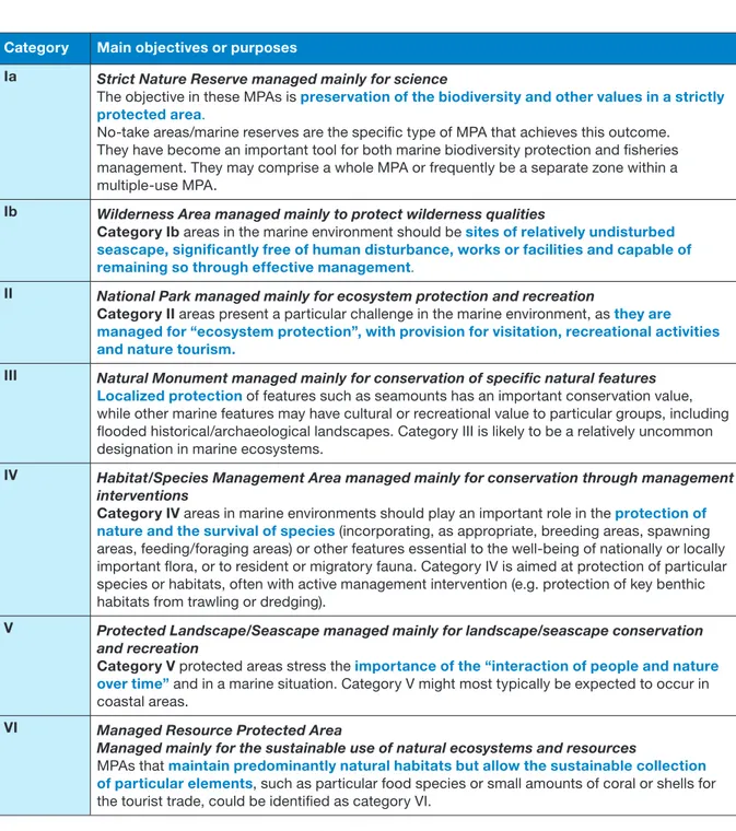
Not all MPAs offer full environmental and species pro-tection. Indeed in the design of an MPA, it is common practice to identify the management category as defined by the International Union for the Conservation of Na-ture (IUCN) (Dudley, 2008) – see Table 1. The categories range from totally protected areas to areas managed for sustainable use of resources. Different management plans are applicable to each category with Categories V and VI offering somewhat less protection to the eco-systems. Supplementary guidelines provide additional advice on applying these IUCN categories. These in-clude guidance on how characteristics of the marine environment affect MPAs, applying the categories to dif-ferent zones in an MPA, detailing relationships between the categories and different activities (Day et al., 2012), and clearly indicating that areas allowing extractive use with no long-term conservation goal should not qualify as MPAs.
A. General introduction
A current on-going debate about ‘what counts as an MPA’ 1 recalls two new global tabulations of MPAs – the
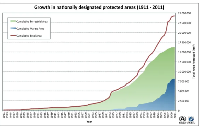
MPA Atlas (http://mpatlas.org/) and a calculation by the Marine Reserves Coalition, both taking a more inclusive position that incorporates a wide range of sites than the stricter IUCN-WCPA definition. This presents an as yet unresolved choice on how global MPA coverage should be measured. Despite an estimated quadrupling of MPA coverage over the last 10 years (see Figure 1), there is concern that progress on defining MPAs, based on MPA coverage as the primary indicator, is very slow on a global scale. According to Spalding et al. (2010) approximately 4.21 million km2, 1.17% of the world’s
oceans and 2.86% of the total marine area within Ex-clusive Economic Zones, were protected at the start of 2010. However, there is a growing trend to define very large MPAs such as the Chagos MPA of 545,000 km2
that was defined in 2010, and prospective designations in Australia, New Caledonia and the Cook Islands. A re-evaluation by the Nature Conservancy (2012) estimates
1 MPA News 14(3) November/December 2012 (http://depts.washington. edu/mpanews/issues.html)
that coverage has increased to 8.3 million km2, 2.3% of
the world’s oceans and 7.9% of continental shelf and equivalent areas (<200m deep) and 1.79% of off-shelf waters with only 0.17% of the high seas.
The global distribution of protected areas is both un-even and unrepresentative at multiple scales. The Na-ture Conservancy (2012) analysed both biogeographic and political coverage. They concluded that whilst there is now MPA representation in all coastal realms and provinces, this masks a spectrum of eco-region cov-erage and a paucity of covcov-erage of pelagic provinces in offshore waters. Similarly, whilst 28 countries and territories (including 10 Member states of the EU) have over 10% coverage, 111 countries and territories have less than 1% MPA coverage (including 11 who have no recorded MPAs) (Nature Conservancy, 2012).
The progression from the single MPA vision to the MPA network vision is gaining momentum (Sala et al., 2002; Dudley, 2008; Higgins et al., 2008; Laffoley, 2008). Eco-logical benefits include protecting representative areas of species and habitats, including threatened species and habitats through all stages of their lifecycle. In addi-tion, MPA networks have been recognised as beneficial to both fisheries (Hall and Mainprize, 2004; Pitchford et
al., 2007) and to socio-economic welfare (Pomeroy et al., 2005). However, design and management of
net-works is still relatively poorly understood (Johnson et al., 2008). It is important that MPAs cover the full spectrum
of ecosystems and vulnerable species and that they are part of a broader ecosystem-based management ap-proach in which networks of MPAs play a significant role (Rogers et al., 2007). Currently the global set of MPAs does not represent an effective network on a hierarchi-cal shierarchi-cale (e.g. national to regional to global) and most progress in the near future is likely to be made at the national and regional scales. Toropova et al., 2010 and Agardy et al., 2011 list 5 shortcomings of MPAs including 1) many MPAs are too small to achieve their goals, 2) many are inappropriately planned or managed, 3) many fail due to degradation of the surrounding unprotected area, 4) many do more harm than good due to displace-ment and unintended consequences of managedisplace-ment, 5) MPAs may create a dangerous illusion of protection when in fact no protection is occurring. Like individual
MPAs, once established, networks of MPAs need to be effectively managed with enforcement of the rules plus regular assessment to ensure that the objectives are being achieved (Toropova et al., 2010). Management, enforcement and assessment are often more difficult and costly in marine sites as opposed to terrestrial sites, particularly in remote high-seas areas with a low level of regulation for fishing vessels. In areas beyond national jurisdiction legislation may also be more complex.
What is a Marine Protected Area?
The definition of an MPA has evolved over time, and relies on the same concepts. Until recently the most commonly used definition of an MPA was provided by the IUCN:
“Any area of intertidal or subtidal terrain,
togeth-er with its ovtogeth-erlying wattogeth-er and associated flora, fauna, historical and cultural features, which has been reserved by law or other effective means to protect part or all of the enclosed environment”
(Kelleher, 1999).
The most recent definition was established in 2007 by IUCN-WCPA and covers all protected areas whether marine or terrestrial. Although this makes the definition less specific, it eliminates problems of definition when the MPA spans both land and sea. The definition clearly identifies the long-term con-servation focus.
A protected area is “A clearly defined
geographi-cal space, recognised, dedicated and managed, through legal or other effective means, to achieve the long-term conservation of nature with associated ecosystem services and cultural values” (Dudley, 2008).
Under this new definition, regulated fisheries (among other human activities) within an MPA may be pos-sible where there is no conflict with long-term conservation objectives.
A. General introduction
Table 1. Application of categories in marine protected areas (from IUCN Dudley, 2008)
Category Main objectives or purposes
Ia Strict Nature Reserve managed mainly for science
The objective in these MPAs is preservation of the biodiversity and other values in a strictly protected area.
No-take areas/marine reserves are the specific type of MPA that achieves this outcome. They have become an important tool for both marine biodiversity protection and fisheries management. They may comprise a whole MPA or frequently be a separate zone within a multiple-use MPA.
Ib Wilderness Area managed mainly to protect wilderness qualities
Category Ib areas in the marine environment should be sites of relatively undisturbed seascape, significantly free of human disturbance, works or facilities and capable of remaining so through effective management.
II National Park managed mainly for ecosystem protection and recreation
Category II areas present a particular challenge in the marine environment, as they are managed for “ecosystem protection”, with provision for visitation, recreational activities and nature tourism.
III Natural Monument managed mainly for conservation of specific natural features
Localized protection of features such as seamounts has an important conservation value, while other marine features may have cultural or recreational value to particular groups, including flooded historical/archaeological landscapes. Category III is likely to be a relatively uncommon designation in marine ecosystems.
IV Habitat/Species Management Area managed mainly for conservation through management
interventions
Category IV areas in marine environments should play an important role in the protection of nature and the survival of species (incorporating, as appropriate, breeding areas, spawning areas, feeding/foraging areas) or other features essential to the well-being of nationally or locally important flora, or to resident or migratory fauna. Category IV is aimed at protection of particular species or habitats, often with active management intervention (e.g. protection of key benthic habitats from trawling or dredging).
V Protected Landscape/Seascape managed mainly for landscape/seascape conservation
and recreation
Category V protected areas stress the importance of the “interaction of people and nature over time” and in a marine situation. Category V might most typically be expected to occur in coastal areas.
VI Managed Resource Protected Area
Managed mainly for the sustainable use of natural ecosystems and resources
MPAs that maintain predominantly natural habitats but allow the sustainable collection of particular elements, such as particular food species or small amounts of coral or shells for the tourist trade, could be identified as category VI.
A. General introduction
A.2 European and regional initiatives
Within Europe a large number of different types of spa-tial marine management units have been defi ned (see Appendix II A1). Some of these are recognised inter-nationally and some are country-specifi c e.g. a Marine Conservation Zone (MCZ) is new type of reserve in-troduced under the UK Marine Act. The establishment of European MPA networks should contribute to and take account of States’ obligations under international Conventions and Directives, including EC Directives, measures taken under the Berne, Bonn and Ramsar Conventions, the Convention on Biological Diversity, Regional Seas Conventions, the Trilateral Wadden sea Co-operation and the commitments made, inter alia, at the World Summit on Sustainable Development and the North Sea Conferences.
EU Directives
Natura 2000 is an EU initiative which supports prac-tical implementation of the Habitats Directive 2 and
the Birds Directive 3, both of which include legally
bind-ing marine components. The Birds Directive requires the establishment of Special Protection Areas (SPAs) for birds, whilst the Habitats Directive requires Special Areas of Conservation (SACs) to be designated for par-ticular species and habitats, which are listed respec-tively in Annexes I and II of the Habitats Directive. Sites designated under the Habitats Directive, are built in three stages: 1) National Lists of Sites of Community Importance (SCIs) are produced based on ecological criteria; 2) approval by the European Commission of the defi nitive lists of Sites of Community Importance for each biogeographical region; 3) Designation, at
na-2 Directive 9na-2/43/EEGC of na-21 May 199na-2 on the Conservation of Natural Habitats and of Wild Fauna and Flora, PB L 206, 22 July 1992 http:// ec.europa.eu/environment/nature/legislation/habitatsdirective/index_ en.htm.
3 Directive 79/409/EEG of 2 April 1979 on the Conservation of Wild Birds, PB L 103, 25 April 1979
http://eur-lex.europa.eu/LexUriServ/site/nl/consleg/1979/L/01979L0409-20070101-nl.pdf.
Figure 1. Growth in nationally designated protected areas (1911-2011). Graph excludes 43,674 protected areas with unknown year of
establishment. Source: IUCN and UNEP-WCMC (2012) The World Database on Protected Areas (WDPA): February 2012. Cambridge, UK: UNEP-WCMC. http://www.bipindicators.net/pacoverage 0 2 500 000 5 000 000 7 500 000 10 000 000 12 500 000 15 000 000 17 500 000 20 000 000 22 500 000 25 000 000 1911 1913 1915 1917 1919 1921 1923 1925 1927 1929 1931 1933 1935 1937 1939 1941 1943 1945 1947 1949 1951 1953 1955 1957 1959 1961 1963 1965 1967 1969 1971 1973 1975 1977 1979 1981 1983 1985 1987 1989 1991 1993 1995 1997 1999 2001 2003 2005 2007 2009 2011
Total Area Protected (
km
2)
Year
Growth in na8onally designated protected areas (1911 -‐ 2011)
Cumula1ve Terrestrial Area Cumula1ve Marine Area Cumula1ve Total Area
Source: IUCN and UNEP-WCMC (2012) The World Database on Protected Areas (WDPA): February 2012. Cambridge, UK: UNEP-WCMC. Note: Excludes 43,674 protected areas with no known year of establishment.
0 2 500 000 5 000 000 7 500 000 10 000 000 12 500 000 15 000 000 17 500 000 20 000 000 22 500 000 25 000 000 1911 1913 1915 1917 1919 1921 1923 1925 1927 1929 1931 1933 1935 1937 1939 1941 1943 1945 1947 1949 1951 1953 1955 1957 1959 1961 1963 1965 1967 1969 1971 1973 1975 1977 1979 1981 1983 1985 1987 1989 1991 1993 1995 1997 1999 2001 2003 2005 2007 2009 2011
Total Area Protected (
km
2)
Year
Growth in na8onally designated protected areas (1911 -‐ 2011)
Cumula1ve Terrestrial Area Cumula1ve Marine Area Cumula1ve Total Area
Source: IUCN and UNEP-WCMC (2012) The World Database on Protected Areas (WDPA): February 2012. Cambridge, UK: UNEP-WCMC. Note: Excludes 43,674 protected areas with no known year of establishment.
A. General introduction
tional level, of Special Areas of Conservation, including the approval of the conservation measures required to support them (e.g. management plans). Marine SACs are in many aspects synonymous with the traditional concept of MPAs. However, only a small fraction of the listed species and habitats are marine. Compared with 230 terrestrial habitats, only 9 marine habitats are in-cluded in the EU Habitats Directive. Moreover, these conform only to very general categories and include no open-water habitats. In this respect, there are many gaps concerning marine species. For example, many deep sea habitats are not specifically listed and are not being considered for ‘priority natural habitat’ qualifica-tion. Deep-sea ecosystems which are integrated in the Natura 2000 framework, such as seamounts and hydro-thermal vents, are included on a voluntary basis. The latest report lists 2,341 marine Natura sites covering an area of 217,464 km2 (Natura 2000 Newsletter, no. 32,
July 2012 http://ec.europa.eu/environment/nature/info/ pubs/natura2000nl_en.htm). Many of these, however, are small and in coastal or inland waters. The Emerald network 4 extends the Natura 2000 network to some non-EU countries.
Although implementation of the Natura 2000 network is mandatory for all Member States there are issues about limiting some human activities such as fishing and ship-ping. The conservation of marine fisheries resources belongs exclusively to the competence of the EU, within the framework of the Common Fisheries Policy (CFP) 5.
Environmental issues however, are shared between the EU and the Member States 6. Thus it is not clear
to what extent the Member States have legal authority to take measures for the restriction of fishing activities within the framework of marine nature conservation, and whether such measures can be taken through the CFP. Four possible options exist: 1. fisheries can only be re-stricted by the EU within the framework of the CFP; 2. fisheries can also be restricted by Member States within the framework of the CFP; 3. restrictions to fisheries as a tool for MPA protection is seen as a nature conservation measure and is taken by the individual Member State; 4. nature conservation measures are taken by the EU. The final decision of the appropriate legal basis will eventu-ally have to be taken by the European Court of Justice. However, the European Court of Justice has not yet had cause to make clear what should be the appropri-ate legal basis for measures restricting the activities of fishing vessels for the purposes of nature conservation (Owen, 2004a and b), although for individual MPAs (such as Bratten, Sweden – see box on page 15) a way forward
4 http://www.coe.int/t/dg4/cultureheritage/nature/econetworks/ default_en.asp
5 Article 3(1)(d) and article 4(2)(d) of the Treaty on the Functioning of the European Union (TFEU).
6 Article 4(2)(e) of the TFEU.
has been found.
The Water Framework Directive (WFD, 2006/60/ EC) 7 and the Marine Strategy Framework Directive
(MSFD, 2008/56/EC) 8 both call for integrated
ecosys-tem management and set targets of good ecological or environmental status. The WFD covers lakes, rivers, transitional and coastal waters, while the MSFD for all marine territorial waters (including coastal). The step from WFD to MSFD implies a better incorporation of an Ecosystem Approach to Management, as it requires elevating consideration from the structural commu-nity level to a functional ecosystem assessment (Van Hoey et al., 2010). The MSFD has added a new impetus within the EU since it will establish a framework within which Member States will take measures to maintain or achieve ‘good environmental status’ (GES) in the marine environment by 2020. These measures must address spatial protection in order to contribute to coherent and representative networks of MPAs that adequately cover the diversity of the constituent ecosystems.
The challenge of establishing networks of MPAs and thereby protecting biodiversity and ecosystem function is recognised as an essential step by all the EU marine and maritime policies. The implementation of the Natura 2000 Network is at the core of the entire process. Within the framework of the CFP however, it can be argued that the aim of a ‘sustainable’ use (conservation and management of fishery resources) is primarily aimed at continuity of the fishing activity rather than solely envi-ronmental concerns. It is clear that a ‘sustainable use’ can only be achieved when pressure reduction plays a key role in the management of MPAs and marine areas in general. These conflicts can only be resolved via the use of ecosystem-based marine spatial management, which should become the essential approach for the integrated management of the sea (Katsanevakis et al., 2011).
Regional Initiatives
The European Regional Seas Conventions, together with related Agreements, have promoted the designation of MPAs in marine areas under their respective jurisdic-tions as follows:
HELCOM 9. In the Baltic, appropriate Natura 2000 sites
are to be designated as Baltic Sea Protected Areas (BSPAs) and new BSPAs are to be designated by in-dividual member states. A BSPA should give particular
7 Directive 2000/60/EC of the European Parliament and of the Council establishing a framework for the Community action in the field of water policy
8 Marine Strategy Framework Directive (MSFD), Directive 2008/56/EC, of 17 June, OJ L 164/19.
A. General introduction
protection to conserve biological and genetic diversity and should protect ecological processes and ensure ecological function (HELCOM Recommendation 15/5 on BSPAs). To date, 159 BSPAs have been designated covering 42,823 km2 and representing 10.3% of the
marine area (HELCOM, 2010a). Analysis of network co-herence in the Baltic was the subject of the EU-funded BALANCE project (2002-2005) 10. Subsequently, despite
encouraging developments, it has been concluded that full management plans are not in place and the MPAs established to date have been judged to not yet form a coherent or comprehensive network (HELCOM 2010b). This judgement took into account adequacy in terms of size, 21 indicator species and 7 biotype indicators, selected essential habitats, and the environmental qual-ity of the network in relation to three key anthropogenic pressure criteria. An evaluation was also made of rep-resentativity, replication and connectivity.
10 http://balance1.uni-muenster.de/
OSPAR 11. In the North East Atlantic, the OSPAR
Com-mission is committed to establish a network of MPAs as part of its programmes and measures (OSPAR, 2003a). OSPAR maintains an annual status report of MPAs which have been established in waters belong-ing to their Contractbelong-ing Parties (includbelong-ing appropriate Natura 2000 sites) and in Areas Beyond National Juris-diction (ABNJ) included in the ‘OSPAR maritime area’. The interim 2012 report (OSPAR, 2012) lists 283 sites, including 276 MPAs situated within the national waters of Contracting Parties and seven MPAs in ABNJ. Col-lectively, these sites cover 654,898 km2 or 4.83 % of
the ‘OSPAR maritime area’ in the North-East Atlantic. This percentage, however, masks wide variability with 16% of coastal waters being designated as MPAs and 0.89% of offshore territorial waters. The distribution of MPAs across the five OSPAR Regions is also
imbal-11 http://www.ospar.org/content/content.asp?me nu=00120000000011_000000_000000 Bratten and CFP
began and biological and social values of the area and threats to these values were identified by the Bratten area theme group, consisting of members from both national and regional authorities and scientists, repre-senting Sweden, Norway and Denmark. Discussions followed with Greenpeace and the Swedish Minister of Environment, who want the fisheries in the Natura 2000 sites to be regulated by individual permissions. Neither the theme group for Bratten, nor the Danish government agree, preferring instead to use the CFP. At a meeting between the theme group and fishermen and their organizations from the three countries, the fishermen were informed about the values of the area and they, in turn, informed the theme group about fisheries. There were also discussions about how ex-tensive the threats from the fisheries are and how they can be reduced. A similar meeting was subsequently held with the Swedish Angling Association.
Recent work on the management plan has includ-ed meetings in December 2012 with a representa-tive group of fishermen and the Swedish Angling Association to discuss how the regulations should be designed, and a stakeholder workshop to present and discuss the proposed regulations as well as other parts of the Management plan. Following a further pe-riod of consideration, the management plan will be established and the proposed fishery regulations will be handed over to the Swedish Agency for Marine and Water Management (SwAM) for EU negotiations. Bratten is a large offshore area in the Swedish
Exclusive Economic Zone of Skagerrak which was recently added to the Natura 2000 and OSPAR MPA networks. Bratten characteristics are unique to Sweden, with different canyons cutting through the landscape including reefs (Natura 2000 habitat 1170) which are home to many unusual and threatened species (according to the Swedish red list, based on the IUCN criteria). The reefs include several unusual species of horn corals (of which some are threatened) eight species of sea pens and the Gorgons head bas-ket star (Gorgonocephalus caputmedusae).
The main “threats” to the biological values of the area are identified as trawling and angling. Shrimp trawl-ers, mainly from Denmark and Sweden, operate in the eastern part of the area. Other commercial species of importance in the area are plaice, saithe, cod, ne-phrops, haddock and anglerfish. Commercial landings comprise a diverse range of species and can include deep living and threatened species. The area is also of importance for recreational fishing.
The management plan for Bratten falls within the In-terreg Project “Hav möter Land” (Sea meets Land). Since the area was proposed by the Swedish Govern-ment to be included in the Natura 2000 network, per-mits are needed for all new activities that can damage the Natura 2000 habitats and species according to the Natura 2000 legislation in the Swedish Environ-mental Code. A management plan for the area is not yet established. However, during 2012 the process
A. General introduction
cover a total area of 287,065km2 protecting a series
of seamounts and sections of the Mid-Atlantic Ridge and hosting a range of vulnerable deep-sea habitats and species. Four of the MPAs were established in collaboration with Portugal. A seventh ‘pelagic’ High Seas MPA, Charlie-Gibbs North (178,094 km2), was
des-ignated in 2012 in waters superjacent to an Icelandic submission to the Commission on the Limits of the Con-tinental Shelf. Because of the constraints of the Law of the Sea Convention, major challenges can occur when MPAs are defined in areas that span the boundary from national jurisdiction to areas beyond national jurisdiction (Ribeiro, 2010). In these cases the approval of a man-anced. The Greater North Sea, the Wider Atlantic and
the Celtic Seas are the best represented OSPAR Re-gions, with 9.44%, 7.56%, and 4.97% coverage respec-tively, while coverage of the Arctic Waters is at 1.47%, and the Bay of Biscay and Iberian Coast have less than 1% protected by OSPAR MPAs. Final figures for 2012 are expected to confirm that MPA coverage exceeded 5% of the OSPAR Maritime Area by the end of 2012 (pers. comm. OSPAR Secretariat; Based on Draft 2012 Status Report of the OSPAR Network of MPAs, to be published in June 2013).
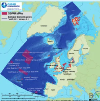
The 6 MPAs in ABNJ were established by OSPAR at its Ministerial Meeting in 2010 (Bergen, Norway). They
in order to protect the whole ecosystem. OSPAR gives good examples of this strategy. At its meeting in September 2010 (Bergen), OSPAR established six marine protected areas (Figure 2) covering a total area of 287,065 km2 protecting a series of seamounts and
sections of the Mid-Atlantic Ridge and hosting a range of vulnerable deep-sea habitats and species.
Figure 2. Map of the OSPAR Network of Marine Protected Areas (as of end of June 2012) prepared for OSPAR by Mirko Hauswirth, German Federal Agency for Nature Conservation (BfN).
Four of the MPAs (Altair, Antialtair and the Josephine Seamounts High Seas MPAs, as well as the Mid-Atlantic Ridge North of the Azores High Seas MPA) were established in collaboration with Portugal.
Background
OSPAR has taken on the responsibility to define MPAs in Areas Beyond National Jurisdiction in the North East Atlantic. From a legal point of view the ‘Areas Beyond National Jurisdiction’ include the ‘high seas’ and the ‘Area’. According to the Law of the Sea Convention (LOSC), of 1982, the ‘high seas’ only includes the water column superjacent to the seabed beyond 200 nautical miles, if the coastal State declared an exclu-sive economic zone with this extension, and the living resources of the seabed beyond the limits of the (ju-ridical) continental shelf. Actually, with regard to the seabed beneath the high seas, a distinction must be made between the ‘Area’ and the ‘continental shelf’. The ‘Area’ only embraces the mineral resources found in the seabed and subsoil beyond national jurisdic-tion. The ‘continental shelf’ embraces the mineral and other non-living resources of the seabed and subsoil, as well as the living organisms belonging to sedentary species, under national jurisdiction. This distinction is of great relevance, namely in the situa-tions where a coastal State has submitted a process to the Commission on the Limits of the Continental Shelf in order to establish the outer limits of its con-tinental shelf. Cases may occur where an ecosystem includes features and organisms belonging to the out-er (‘extended’) continental shelf (undout-er coastal State jurisdiction) plus features and organisms belonging to the high seas (beyond coastal State jurisdiction).
MPAs in the Wider Atlantic
The legal divisions of the ocean are largely based on the situation that prevailed in 1982. Nevertheless, from an ecological point of view, the legal statute of the ocean may not be coherent. As an example, in the case of seamounts located in the outer (‘extended’) continental shelf, commitments must be concluded between the coastal State and regional organizations
Case study 1: High Seas, designing MPAs beyond national jurisdiction
A. General introduction
with the European Union fisheries policy (as regards its Member States), or international shipping which is covered by the International Maritime Organization (IMO). With regard to the other two MPAs estab-lished by OSPAR in the Bergen meeting – the Milne Seamount Complex MPA and the Charlie-Gibbs South MPA – another complicating factor must be added. These MPAs embrace the seabed and the superjacent water column, being both beyond national jurisdic-tion. This means that, according to LOSC, the seabed is qualified as ‘Area’ and the water column as ‘high seas’. Therefore, mining is covered by the International Seabed Authority (ISA) competence. Hence OSPAR now needs to reach further agreements with the men-tioned bodies before full protection can be given to the six new sites. The North-East Atlantic Fisheries Commission has already imposed closures for bottom fisheries in four of the new MPA locations though Milne Seamount and Josephine Seamount do not have any current protection.
Effectively, the four MPAs are complementary to an-other four MPAs embracing the (outer ‘extended’) continental shelf (seabed and subsoil) nominated by Portugal. With this solution Portugal and OSPAR overcame the difficulty to protect the whole seamount ecosystems; the protection and management of the seabed and subsoil is under Portuguese responsibil-ity and the protection and management of the water column is under OSPAR responsibility. This approach obviously requires an effective collaboration between the two parties.
Issues
Due to the legal divisions of the ocean (Figure 3) and the inherent distribution of jurisdiction and compe-tences, the protection and management of the water column related to the four OSPAR high seas MPAs faces other complicated factors. Namely, OSPAR does not have competent authority for controlling fishing activities, which is covered by the North East Atlantic Fisheries Commission (NEAFC), eventually combined
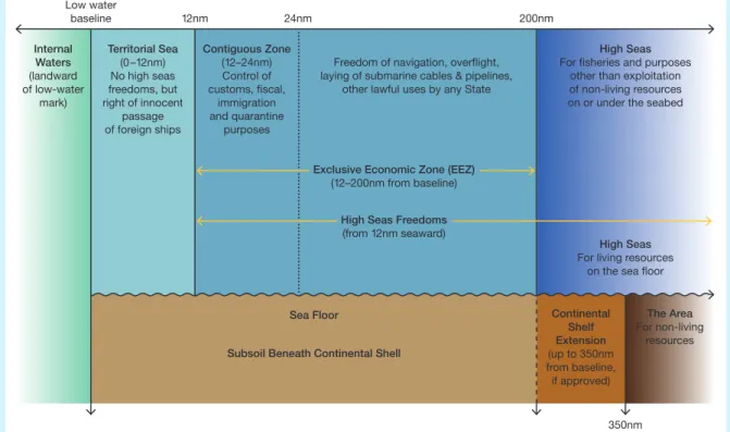
Low water baseline 12nm 24nm 200nm 350nm Territorial Sea (0–12nm) No high seas freedoms, but right of innocent passage of foreign ships Internal Waters (landward of low-water mark) Contiguous Zone (12–24nm) Control of customs, fiscal, immigration and quarantine purposes
Exclusive Economic Zone (EEZ) (12–200nm from baseline)
High Seas Freedoms (from 12nm seaward) Continental Shelf Extension (up to 350nm from baseline, if approved) Sea Floor
Subsoil Beneath Continental Shell
High Seas For fisheries and purposes
other than exploitation of non-living resources on or under the seabed Freedom of navigation, overflight,
laying of submarine cables & pipelines, other lawful uses by any State
High Seas For living resources
on the sea floor The Area For non-living
resources
Figure 3. Maritime Zones under United Nations Convention on the Law of the Sea (UNCLOS) of 1982 (redrawn from original figure
provided by Montserrat Gorina-Ysern, PhD, Independent LOS Consultant, USA). nm = nautical mile
agement plan or individual conservation measures may need to respect both national requirements and those of international bodies.
Barcelona Convention: Most countries bordering the
Mediterranean only recognize their offshore territory to 12 nautical miles, with the area beyond being defined as ‘Area’ and high seas. The designation of MPAs within territorial waters is very uneven across the Mediterra-nean with, for example, 26 listed in the MPA GLOBAL da-tabase (http://mpaglobal.org/) for France, 19 for Greece, 85 for Italy and 36 for Spain, whilst many other countries have very few. Many of the MPAs declared in the Medi-terranean are very small. For example, of the 26 MPAs listed in French territory 14 are less than 5 km2 in area.
In contrast, the Columbretes Islands MPA at the edge of the Spanish Mediterranean continental shelf offers full protection from fishing to 55 km2 of rocky and
coral-ligenous habitats (see case study 6). The largest by far is the Pelagos sanctuary for marine mammals (qualified as a Specially Protected Area of Mediterranean Impor-tance – SPAMI) which extends for 87,492 km2 including
an area beyond national jurisdiction. Within the Medi-terranean there are numerous MPA network initiatives to encourage more MPA designations. The Barcelona Convention embraces both MPAs established in mari-time areas belonging to their Contracting Parties 12 and
in areas beyond national jurisdiction (e.g. the SPAMI)
12 http://www.unep.ch/regionalseas/regions/med/t_barcel.htm
and the most recent Mediterranean-wide evaluation of designation progress in the biodiversity ‘hotspot’ can be found in the 2012 status report (Gabrie et al., 2012). The Regional Activity Centre for Specially Protected Ar-eas (RAC/SPA) was established in 1985 by a decision of the Contracting Parties to the Barcelona Convention with the aim of assisting Mediterranean countries in the conservation of habitats, ecosystems, sites and species in the Mediterranean 13. MedPan (http://www.medpan.
org/) is a network of MPA managers, with 63 members and partners from 17 countries around the Mediterra-nean. The objective of the network is to improve the ef-fectiveness of MPA management in the Mediterranean. The IUCN’s Centre for Mediterranean Cooperation is actively promoting MPA designation in the region. Nev-ertheless, the IUCN/WWF/MedPan report (Abdulla et al., 2008) predicted that despite the large number of existing protected sites, “the present system of Mediterranean marine protected areas is not representative and the objectives set by the Biodiversity Convention for 2012 will most likely not be attained. The management effec-tiveness of Mediterranean marine protected areas must be improved. Furthermore, marine protected areas are threatened by substantial external pressures at local, regional and global levels.” This has prompted an ini-tiative to identify large scale ecological units, based on
13 http://ec.europa.eu/world/agreements/
prepareCreateTreatiesWorkspace/treatiesGeneralData.do?step=0&redir ect=true&treatyId=598
A. General introduction
Lessons learnt Research priorities and needs
Seabed and subsoil that are part of the outer (‘extended’) continental shelf are under jurisdiction of the relevant coastal state. Hence the water column and seabed may be subject to different jurisdiction
1) Seamounts: A) direct study and comprehensive understanding of seamount ecosystems; B) specifically research on the interaction between features and living organisms related to the seabed and the ones related to the water column (e.g. complementarity; high, medium or low dependency etc.)
2) Hydrothermal vent fields: improve knowledge about the interaction with the water column of the living communities, in order to find out if an MPA may be effective with the sole protection of the seabed
3) Codes of conduct and guidelines Synergistic management
efforts are essential
1) between Member States and OSPAR,
2) between OSPAR and other competent authorities (RFMO; EU; IMO; ISA)
1) Research on the damaging effects of fisheries and other human activities related to deep-sea ecosystems (e.g. seamounts, hydrothermal vent fields, cold coral reefs etc.)
2) Develop science-based autonomous management measures concerning the seabed and the water column that, as a whole, assure the protection of the whole ecosystem
3) Support development of a supra-national approach to deep-sea ecosystems management (for the ones located in areas beyond national jurisdiction)
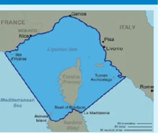
biogeographic eco-regions and associated sub-regions, assessment of critical habitats (Hoyt and Notarbartolo di Sciara, 2008), and acknowledgement of knowledge gaps (e.g. ecology and biomass of key species such as northern krill in the Ligurian-Corsican area) reflecting a geographical and seasonal imbalance of data availabil-ity. A proposal was put forward by Oceana (2011) for a network of Mediterranean MPAs that would cover a wide variety of habitats and, when combined with existing MPAs, would reach a total of 12% of the surface of the Mediterranean (see http://oceana.org/en/eu/our-work/ habitats-protection/mediterranean/mednet/overview).
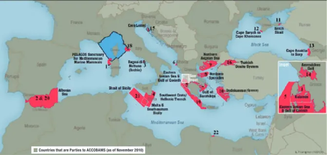
ACCOBAMS: ACCOBAMS (http://www.accobams.
org/) is a cooperative tool for the conservation of ma-rine biodiversity in the Mediterranean and Black Seas. It has recommended the establishment of 22 MPAs in the Mediterranean and Black Sea to protect cetaceans (ACCOBAMS Resolution 4.15; see Figure 4).
CoCoNet: CoCoNet (http://www.coconet-fp7.eu/) is a
European project tackling the need for interconnected MPAs in the Mediterranean and the Black Sea regions. Involving 22 countries from three continents (Africa, Asia, Europe), the project has created a network of scientific excellence for issuing guidelines for effective transnational environmental management, encompass-ing local (sencompass-ingle MPA) to regional (networks of MPAs) from the shore to the high and deep sea, coupled with sea-based wind energy potential.
A.3 Towards ecosystem-based
marine spatial management
Individual MPAs often end up being rather small in size owing to numerous competing demands for use of the marine space. In contrast, the range of many mobile species can be large. Migratory mammals, birds and fish can travel hundreds or even thousands of kilometres to breed or to feed. Adequate protection for these or-ganisms can be provided by defining a coherent series of MPAs that are designed to address the vast home ranges of some species, whilst leaving areas in between open to commercial activity. Such networks have been defined by the WCPA/IUCN as “A collection of individual
MPAs operating cooperatively and synergistically, at various spatial scales, and with a range of protection levels, in order to fulfil ecological aims more effectively and comprehensively than individual sites could alone.” (WCPA/IUCN 2007, p.3). These networks of MPAs can
also be designed to include representative examples of all the different ecosystems, habitats and commu-nities over a wide area, providing stepping-stones of genetic, demographic and ecological connectivity. MPA networks are equivalent to creating vegetation corridors on land. The concept of the MPA network also opens up the possibility to design from the outset the possibility to manage species and ecosystems under a changing climate regime.
Figure 4. Recommendation for 22 MPAs in the Mediterranean and Black Sea to protect cetaceans as defined by ACCOBAMS (source
ACCOBAMS-MOP4/2010/Res 4.15). Disclaimer: The designations employed and the presentation of the information on this figure do not
imply the expression of any opinion whatsoever on the part of ACCOBAMS concerning the legal status of any country, territory, city or area of its authorities, or concerning the delimitation of its frontiers or boundaries.
A. General introduction
Some countries have begun to plan networks of MPAs as part of larger frameworks of ecosystem-based man-agement, integrated ocean governance and integrated coastal management. This concept, known as Ecosys-tem-Based Marine Spatial Management (EB-MSM), is gaining momentum as a planning tool to make informed and coordinated decisions about how to use marine resources in a sustainable manner (see box above). EB-MSM is being promoted by several European countries and by OSPAR and HELCOM and is being informed by current research (e.g. MESMA 14). By using this approach
a variety of management plans can be devised ranging from areas with full protection – that is, areas where no extractive activities such as fishing or the removal of resources are permitted, to areas with controlled use.
14 www.mesma.org
MPAs within the context of ecosystem-based marine spatial management
an integrated approach towards the stewardship of natural systems and adopting a long-term approach. The emphasis is on a nested or hierarchical approach with overarching policy frameworks, national plans and local actions.
MPAs and EB-MSM or MSP are not interchangeable concepts. EB-MSM has a broader remit and provides an overall spatial framework for managing maritime activities. Both MPA networks and MSP are recog-nised as practical tools for implementing the EB-MSM approach, and both represent area-based tools that are recognised as being insufficient in achieving the all-encompassing EB-MSM goals if applied on their own (Douvere, 2008; Halpern et al., 2010; Katsanevakis
et al., 2011). A key difference between MPA networks
and MSP is that the former places emphasis on the protection of ecological features and processes that merit site-specific management measures by con-trolling pressures due to human uses, while the latter also (sometimes primarily) addresses inter-sectoral conflicts that might not be related to conservation. In comparison to MSP, there are fewer economic sectors involved in MPAs in general, and MPA zon-ing restrictions mainly target various forms of fishzon-ing, shipping, and recreational use. Nevertheless, as more and more multiple-use MPAs are being designated, MPA networks also serve multiple ecological, socio-economic, and cultural purposes (Jones 2001; Halpern
et al., 2010).
Ecosystem-based marine spatial management (EB-MSM) is an emerging paradigm of ocean management, which is being promoted by institutions worldwide as the best way to deal with conflicts among various users of the seas and to ensure the sustainability of marine ecosystems and their services to humans (Katsanevakis et al., 2011). EB-MSM recognizes the full array of interactions among ecosystem components and human users, rather than considering in isolation single sectors, species, or ecosystem services. Its goal is to maintain marine ecosystems in a healthy, productive and resilient condition by balancing the increasing diversity and intensity of human activities with the ocean’s ability to provide ecosystem services. Although there are ecosystem approaches to marine management that are not necessarily place-based, in most cases marine ecosystems are fixed in space. Hence, the spatial component is inherently critical in the concept of ecosystem-based management (Katsanevakis et al., 2011).
Marine Spatial Planning (MSP) is a crucial tool for EB-MSM that has emerged as a means of resolving inter-sectoral and cross-border conflicts over maritime space (Ehler, 2008; Halpern et al., 2008; Douvere, 2010). MSP is a public process of analysing and allocating the spatial and temporal distribution of human activities in marine areas to achieve ecological, economic, and so-cial objectives that have usually been specified through a political process (Ehler and Douvere, 2007). MSP sits within the field of environmental planning taking
Aerial photo of Columbretes Islands Marine Reserve (courtesy, Columbretes Islands Marine Reserve, Spain)
B. Design of MPAs
B.1 Design criteria from binding
agendas and legal texts
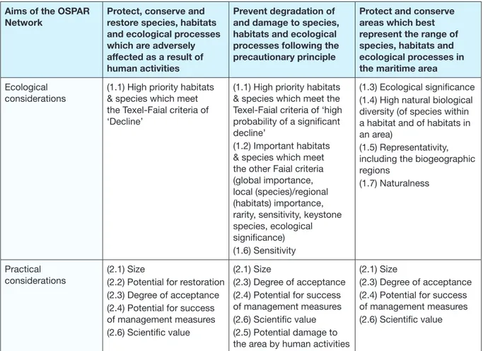
Design issues have long been addressed by MPA practitioners and many organizations are dedicated to the creation of protected areas for both conservation of biodiversity and sustainable use of resources, e.g. the IUCN, the Nature Conservancy, or the UNEP-MAP Regional Activity Centre for Specially Protected Areas (RAC-SPA), and those agencies in charge of designating marine reserves or protected areas at the national level. Guidelines for the identification and selection of MPAs established by OSPAR provide a useful template, com-bining ecological criteria/considerations (subject to prioritisation) with practical criteria/considerations (e.g. comparatively higher stakeholder support and political acceptability). Table 2 (From OSPAR 2003b, Appendix 3) correlates the two sets of OSPAR criteria in the context of the aims of the OSPAR MPA network.
Similar guidelines have been adopted by the Depart-ment of Fisheries and Oceans of Canada (DFO, 2004) based on Uniqueness, Aggregation 15, and Fitness
Con-sequences, while accounting for Resilience and Natural-ness of the area; by other Regional Conventions (e.g. HELCOM 2010b); and by a number of groups who are actively defining MPAs, such as Natural England and the JNCC in the UK (Ashworth et al., 2010). All of the above general selection criteria pertain to the objectives of conservation of biodiversity and associated resources, a major and common goal of most MPAs.
With respect to networks, IUCN has promoted five general criteria to define a MPA network (IUCN-WCPA, 2008): i) include the full range of biodiversity present in the biogeographic region; ii) ensure ecologically sig-nificant areas are incorporated; iii) maintain long-term
15 Aggregation refers to the existence of species aggregations or to the occurrence of critical ecological process within the area, even temporarily
Aims of the OSPAR Network
Protect, conserve and restore species, habitats and ecological processes which are adversely affected as a result of human activities
Prevent degradation of and damage to species, habitats and ecological processes following the precautionary principle
Protect and conserve areas which best represent the range of species, habitats and ecological processes in the maritime area
Ecological considerations
(1.1) High priority habitats & species which meet the Texel-Faial criteria of ‘Decline’
(1.1) High priority habitats & species which meet the Texel-Faial criteria of ‘high probability of a significant decline’
(1.2) Important habitats & species which meet the other Faial criteria (global importance, local (species)/regional (habitats) importance, rarity, sensitivity, keystone species, ecological significance) (1.6) Sensitivity
(1.3) Ecological significance (1.4) High natural biological diversity (of species within a habitat and of habitats in an area)
(1.5) Representativity, including the biogeographic regions
(1.7) Naturalness
Practical considerations
(2.1) Size
(2.2) Potential for restoration (2.3) Degree of acceptance (2.4) Potential for success of management measures (2.6) Scientific value
(2.1) Size
(2.3) Degree of acceptance (2.4) Potential for success of management measures (2.6) Scientific value (2.5) Potential damage to the area by human activities
(2.1) Size
(2.3) Degree of acceptance (2.4) Potential for success of management measures (2.6) Scientific value
Table 2: OSPAR Commission criteria for MPA selection