1Departamento Nacional de Produção Mineral, Superintendência do Amazonas, Manaus (AM), Brazil. E-mail: [email protected] 2Programa de Pós-Graduação em Geociências, Universidade Federal do Amazonas, Manaus (AM), Brazil. E-mail: [email protected] 3Universidade Federal de São Paulo, Santos (SP), Brazil. E-mails: [email protected], [email protected], [email protected]
*Corresponding author.
Manuscript ID: 20160009. Received in: 01/13/2016. Approved in: 05/16/2016. ABSTRACT: In the scope of Solimões-Amazon luvial system be-tween the Negro and Madeira tributaries, three levels of Quaternary luvial terraces overlie the Alter do Chão and Novo Remanso for-mations further than 100 km southward its current main channel. Smooth undulated topography presenting low drainages density formed by sparse secondary plain channels and rounded lakes char-acterizes these deposits. Internally, they show point bars morphology constituted by intercalated layers of mud (silt and clay) and sand forming an inclined heterolithic stratiication. he asymmetric distri-bution of luvial terraces allied to the records of old scroll-bars features and paleochannels in many extensions of the Solimões River suggests the predominance of a meander pattern between 240 to 6 kyears. On the other hand, the development of the current anabranching pattern took place in the last six kyears due to the Holocene sea-level rise, besides the action of neotectonics and rainforest establishment related to the increase of humidity in Amazonia.
KEYWORDS: Amazonian continental Quaternary; Solimões-Amazon luvial system; Amazon basin.
RESUMO: No trecho do sistema luvial Solimões-Amazônia que com-preende os tributários Negro e Madeira, três níveis de terraços luviais Quaternários recobrem as rochas das formações Alter do Chão e Novo Re-manso por mais de 100 km ao sul do principal canal atual. Esses depósitos são caracterizados por uma topograia suavemente ondulada apresentando baixa densidade de drenagens, formadas por canais secundários esparsos e lagos arredondados. Internamente, apresentam morfologias de barras em pontal constituídas por intercalação de camadas de lama (silte e argila), além de areia, formando pares de estratiicações heterolíticas inclinadas. A predominância de um padrão meandrante há 240.000 e 6.000 anos é sugerida pela distribuição assimétrica dos terraços luviais, aliada aos reg-istros de antigas barras em pontal e paleocanais em diversos trechos do Rio Solimões. Por outro lado, o desenvolvimento do atual padrão anabranching se iniciou nos últimos 6.000 anos em virtude da subida do nível do mar no Holoceno, além da ação de eventos neotectônicos e o estabelecimento da lo-resta tropical, que está relacionado ao aumento da umidade na Amazônia. PALAVRAS-CHAVE: Quaternário continental da Amazônia; siste-ma luvial Solimões-Asiste-mazônia; bacia do Asiste-mazonas.
Pleistocene-Holocene sedimentation of
Solimões-Amazon luvial system between
the tributaries Negro and Madeira,
Central Amazon
Sedimentação Pleistocênica-Holocênica do sistema luvial
Solimões-Amazonas entre os tributários Negro e Madeira, Amazônia Central
Eliezer Senna Gonçalves Júnior1,2*, Emílio Alberto Amaral Soares2,
Sonia Hatsue Tatumi3, Marcio Yee3, Juan Carlos Ramirez Mittani3
INTRODUCTION
In the extent of the Solimões-Amazon luvial system, between Negro and Madeira tributaries, the post-Miocene deposits related to channels and marginal areas of the largest Amazonian rivers cover parts of the Cretaceous and Miocene
units of the Amazon Sedimentary Basin (Dino et al. 2006;
2012, Dantas & Maia 2010, Soares et al. 2010). However, in spite of their relevance to the local landscape, there is no formal standard for these deposits. Over the years, they have received diferent denominations and difuse geological boundaries in many studies (Latrubesse & Franzinelli 2002, Rossetti et al.
2005, Riker et al. 2008, Soares 2007, Rozo et al. 2012), and
were occasionally associated with Solimões and Iça Formations (Latrubesse & Franzinelli 2002, Rossetti et al. 2005).
hereby, one of the reasons for the lack of formal stra-tigraphic standards to these post-Miocene deposits in the Amazon Basin is the reduced number of sediment burial ages. Hence, some authors have been successfully using the optically stimulated luminescence (OSL) to determine
luvial terraces ages in Central Amazon (Soares et al. 2010,
Rozo et al. 2012, Fiore et al. 2014). his has been done
due to the higher chronological range in comparison with radiocarbon, as well to the dismissive availability of organic
matter (Tatumi et al. 2008, Fiore et al. 2014).
Regarding the relative low volume of post-Miocene depo-sit ages, many investigations focused on luvial dynamics and geomorphological features in order to understand the deve-lopment of the Solimões-Amazon luvial system, thus indi-cating the currently predominance of a very stable anasto-mosing pattern (Mertes et al. 1996, Latrubesse & Franzinelli
2002, Rossetti et al. 2005, Rozo et al. 2012). On the other
hand, some authors support the prevalence of an anabran-ching luvial style in Solimões-Amazon system in the
pre-sent days (Latrubesse 2008, Soares et al. 2010, Passos et al.
2012). According to Nanson & Knighton (1996), the gene-ric term ‘anabranching river’ is applied to any type of mul-tiple channel systems with stable alluvial islands dividing the low, whereas the term anastomosed river is associated with a speciic subset of low-energy anabranching system.
hus, Rozo et al. (2012) concluded that the current
con-formation of the Amazon River could be considered both anastomosing and anabranching.
Paleochannels and scroll-bar sets have been recognized in Solimões-Amazon system alluvial plain in many diferent rea-ches (Mertes et al. 1996, Latrubesse & Franzinelli 2002, Rozo 2004, Soares 2007, Soares et al. 2010, Teixeira & Soares 2011, Rozo et al. 2012, Gonçalves Junior et al. 2014). However, there is still no consensus about the meaning of these meander-related features. Rozo (2004), Soares et al. (2010) and Teixeira & Soares (2011) suggest the prevalence of a single meander channel that
gradually evolves to an anastomosed river along the Pleistocene, whereas Latrubesse & Franzinelli (2002) and Rozo et al. (2012) assign the alluvial plain meander characteristics to the activity of secondary channels in a multiple-channel river system.
In the present study, the geomorphologic analysis allied to the OSL dating of luvial terraces southward the Solimões-Amazon River in the extension between Negro and Madeira tributaries, grounds the construction of a model for the local landscape evolution, since the Middle Pleistocene until the present days.
GEOLOGICAL SETTING
he Quaternary sedimentation in the Solimões-Amazon luvial system spread between Negro and Madeira tributaries is mostly related to channel areas and alluvial plains (Soares
et al. 2010) that cover Alter do Chão (Kistler 1954) and Novo
Remanso Formations (Rozo et al. 2005,Dino et al. 2012).
According to Latrubesse & Franzinelli (2002), the lower Solimões River alluvial deposits can be divided into three different units, considering their geomorpho-logical and sedimentogeomorpho-logical features:
1. the older scroll-dominated plain formed by a Late
Pleistocene silt-clay rich terrace bearing a well-develo-ped morphology of scroll bars;
2. the impeded loodplain that is eventually inundated by
annual loods and characterized by round or irregular--shaped lakes and grey-greenish muddy sediment depo-sits; and
3. channel-dominated loodplain, gathering current luvial
channel bars, levees and present-day scroll bars deposits.
In a study carried out in the area between the Brazilian-Peruvian border up to the Amazon River outlow, Rossetti
et al. (2005), based on radiocarbon (14C) data, proposed the existence of four diferent levels of Quaternary deposits. hey are laterally discontinuous and perpendicularly settled to the Solimões and Amazon rivers, informally called Q1 (43.7 to 37.4 kyears), Q2 (~27.2 kyears), Q3 (6.73 to 2.48 kyears), and Q4 (280 to 130 years).
On the other hand, Soares et al. (2010), mainly using OSL
data, found ages varying from 65,200 to 7,500 years for luvial ter-races along the Solimões River, between Manaus and Manacapuru, which are disposed in parallel strips along the main channel and extending for tens of meters. Additionally, Fiore et al. (2014) determined ages from 205,000 to 83,000 years associated with luvial deposits in the conluence of Solimões and Purus rivers.
Recently, Rozo et al. (2012) found four diferent
1. terraced deposits represented by Alter do Chão and Novo Remanso Formations, which bear elongated-ramiied lakes commonly mouth-damned;
2. scroll bars deposits (7,500 to 3,400 years old) that shape
most alluvial islands and part of the right bank of the Amazon River, represented by successive intercalations of silty ine-grained sand and grayish clay layers that form inclined heterolithic stratiication (IHS) pairs;
3. loodplain deposits (1,100 to 990 years old) made up
by greyish to brown organic matter-rich, laminated and massive clays, characterized by a very lat surface holding irregularly rounded and oxbow lakes; and, inally,
4. the channel bar deposits represented by present-day
ine-grained sandy Amazon River channel bars, orien-ted along the current main low direction.
Despite the major inluence of sedimentological, geo-morphological, and environmental dynamics in the deve-lopment of the landscape and drainage systems in Central Amazon, some authors have observed the role of neotec-tonics in those processes through the operation of an E-W transcurrent dextral system (Franzinelli & Igreja 1990, Igreja
1998, Igreja et al. 1999). his system probably reactivated
old structures (Costa et al. 1996) and enabled the formation
of half-grabens, which accommodated the largest part of the post-Miocene sedimentation in Central Amazon (Fernandes
Filho 1996, Silva et al. 2007, Franzinelli & Igreja 2011,
Igreja 2012). hus, they caused the straightening of rivers segments (Latrubesse & Franzinelli 2002), and modeled the local landscape.
MATERIAL AND METHODS
Geomorphological analysis of the study area was per-formed using a 6-m-spatial resolution of synthetic aperture
radar images provided by Centro Gestor e Operacional do
Sistema de Proteção da Amazônia (CENSIPAM). It sought to identify the largest lineaments, the secondary channels that straighten segments, the main morphological featu-res of the luvial terraces, and geological boundaries of the studied units.
For the OSL dating procedures, 23 samples were collec-ted from the top sandy layers of the luvial terraces point bars through aluminum tubes of 50 cm long and a 7 cm diameter. A single aliquot regenerative (SAR) dose protocol (Murray & Wintley 2003) was applied on the quartz-rich samples (Fig. 1). No signiicant signal in the infrared stimulated luminescence (IRSL) analysis conirmed the absence of feldspar grains in the aliquots. he protocol application irstly requires a pre-vious sieving in order to attain 180 to 250 µm-sized grains
followed by four hours of H2O2 treatment to eliminate
orga-nic matter. hen, 45 minutes of hydroluoridric acid (HF) 20% exposure to eliminate external alpha ionization contri-bution, two hours of HCL 20% with the purpose of carbo-nates and luorites removal and, inally, heavy liquid treat-ments (Sodium Polytungstat – SPT) in order to separate the quartz grains from the heavy minerals (density = 2.85), and the feldspar from quart grains (density = 2.58).
he OSL measurements were performed through a RisØ TL/OSL reader, model DA-20 (DTU National Laboratory for Sustainable Energy). Blue light was applied for quartz stimulation with one to ive seconds of integration limits and background calculation of 200 to 250 seconds. he best pre-heat temperature obtained through dose recovery test was 220°C, and the test results indicated 10.3 ± 0.5 Gy reco-vered dose. Hoya U-340 optical ilter was used for the OSL signal detection. Radionuclides concentrations for dose rate calculation were measured through gamma spectroscopy with the NaI (Tl) detector, model 802, Canberra Industries Inc., and standard soils samples JR-1, JG-1a, JB-3 and JG-3. he measurements were performed with about 100 g of the
OSL (cts per 0.12 s)
Lx/Tx
2,200 2,000 1,800 1,600 1,400 1,200 1,000 800 600 400 200 0
Time (s)
11 10 9 8 7 6 5 4 3 2 1 0
0 5 10 15 20 25
Natural
56β
0 20 40 60 80 100 120 140 160 180
sediment, which had been previously stored and sealed in a plastic container for two weeks to assure the secular equi-librium. Water content was also measured for the annual dose rate correction. Field gamma-ray spectra were
collec-ted using a Canberra Portable Plus γ- spectrometry system
model 802, equipped with a 2 × 2 inch NaI(Tl) detector. he measurements were performed with the equipment placed at 1.5 m from the ground, and the detector was calibrated according to the procedure described by Murray (1981).
In order to avoid the natural contributions of radionuclides from the soil, the measurements were performed over Guamá River for eight hours. For calculating the annual dose rate, the integral count rate must be converted into counts per area and time N, divided by the efective area of the NaI crystal. For the standard rock, the dose rate is: D = 9.37 N, in which D is in Gyka-1 and N in counts/cm-2s-1 (Prescott & Clay 2000). Cosmic ray dose rates for luminescence and Electron Spin Resonance (ESR) dating are measured with a scintillation counter. he water con-tent in the samples luctuated from 0.69 to 1.11%, however the variations of water between the seasons was not found.
RESULTS
Morphostratigraphic units
Geomorphological analysis from radar images based on depositional morphology of the Solimões-Amazonas River luvial terraces, on secondary drainage patterns in alluvial plain and relief features, allied to ield sampling, supported the deinition of three distinct Quaternary luvial terrace levels, surrounding a few older cores of Alter do Chão and Novo Remanso Formations.
Alter do Chão and Novo Remanso
Formations
Situated between 100 and 50 meters above sea level, Alter do Chão and Novo Remanso Formations consist of elongated cores that are laterally limited by lineaments visi-ble from satellite images, which are mainly pointed NE-SW and NW-SE. White to reddish, occasionally rusty colored, sandstones, mudstones and conglomerates make up these units. hey show a peculiar geomorphology represented by a dissected relief forming hills and plateaus held up by fer-ruginous lateritic paleosoil levels.
Quaternary morphostratigraphic units
he Quaternary luvial terraces of Solimões-Amazon sys-tem, between Negro and Madeira tributaries, are asymmetri-cally distributed and arranged as elongated stripes following the river channel and smoothly South to North raked. hey can be divided into three distinct levels herein informally
denominated as Upper Terrace (UT), Intermediate Terrace (IT) and Lower Terrace (LT), according to their geomorpho-logical (Fig. 2) and geochronogeomorpho-logical features (Tab. 1, Fig. 3).
Upper Terrace
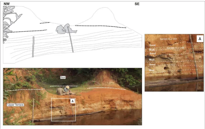
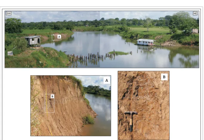
he UT occupies most of the study area and represents the older morphostratigraphic unit of Solimões-Amazon luvial system alluvial plain, presenting OSL ages varying between 240,000 ± 16,000 and 51,000 ± 5,000 years (Tab. 1). Currently, this unit occurs far enough from the modern main channel, free of its annual loods and presenting a modera-tely dissected geomorphological pattern, which is associated with the predominance of sub-rectangular to sub-dendritic drainage types (Fig. 2). Pedogenesis processes enabled the occurrence of a metric orange clay soil layer that allows the installation of large trees over these deposits (Fig. 4).
Preserved old point bars lead to the development of a sequence of smooth valleys and undulations (Fig. 5) that reach up to 80 meters above sea level in the South of the study area, decreasing northward and coming down to merely 30 meters above sea level, near the contact with the younger Quaternary deposits.
Blockage of the lower course of secondary drainages caused by factors such as levees deposits, rise of the main channel water level and, occasionally, the tectonic uplift, formed elongated and branched lakes over the UT surface.
Internally, intercalations in diferent proportions of whi-tish to reddish mud and yellowish to reddish sandy layers
form IHS pairs (sensu homas et al. 1987) in the remaining
point bars features (Fig. 6).
Intermediate Terrace
With OSL ages varying from 30,900 ± 8,000 to 19,100 ± 6,300 years, the IT is disposed as a continuous elongated strip parallel to the Solimões-Amazon luvial system main channel (Fig. 2), which is eventually being subject to the annual loods.
Lower Terrace
Near 18,300 ± 4,000 to 2,000 ± 1,000 years, LT depo-sits occur mostly as elliptical-shaped islands and sometimes as elongated thin strips on the Solimões-Amazon-Madeira luvial system banks (Fig. 2). heir relief is plain with ele-vations between 25 and 10 meters above sea level, contai-ning a few mild undulations formed by sequences of crests and depressions related to kilometric bent accretion lines.
Currently, LT deposits are totally subject to annual loods, and their drainage system is based on narrow lakes formed between the accretion lines and some 200 m wide secondary channels (‘furos’ and ‘paranás’). he surface is covered by small vegetation, mainly made up by grasses and shrubs, seated on a thin undeve-loped soil layer that was originated by hydromorphic processes. Internally, the deposits are composed of intercalations of metric dark-brown silty layers and sub-metric light grey, well selected and ine-grained sandy layers that together make up IHS pairs (Fig. 8).
Some preserved sedimentary structures, like planar bed-ding, cross-stratiication and, in a few cases, laser bedbed-ding, are observed. Furthermore, bioturbation records represent the
post-sedimentary features found on the deposits. Occasionally, younger dark grey centimetric organic matter-rich (partially decomposed pieces of trunks, roots, and leaves) mud layers overlay the IHS pairs.
Tectonic features
he tectonics performs a relevant factor of landscape transformation and geomorphological evolution in the stu-died Pleistocene deposits. Tens of kilometers lineaments, observed by radar images, mold the largest part of the Solimões-Amazon system riverbanks and are responsible for the luvial capture processes on secondary plain chan-nels. Furthermore, these structures contour and shape many relicts of Alter do Chão and Novo Remanso Formations placed in the alluvial plain, sustained by levels of paleo-soils and lateritic crusts.
hese lineaments show two dominant trends controlling most of the secondary drainages in the alluvial plain of the study area: N40-55E and N50-65W, being
compati-ble to the structures pointed by Costa et al. (1996),
con-trolling the Madeira River channel, and those marked by
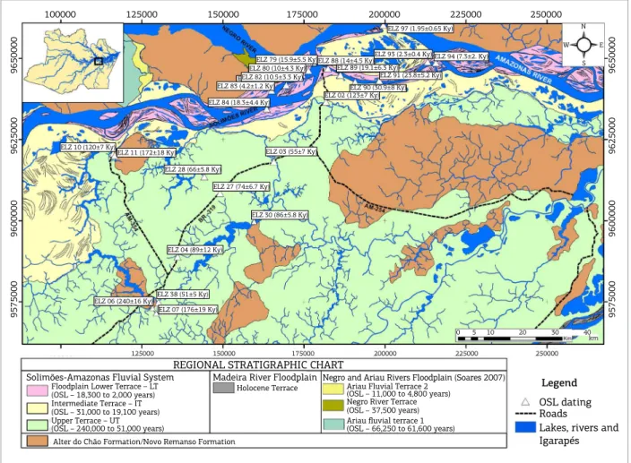
REGIONAL STRATIGRAPHIC CHART Solimões-Amazonas Fluvial System
Floodplain Lower Terrace – LT (OSL – 18,300 to 2,000 years) Intermediate Terrace – IT (OSL – 31,000 to 19,100 years) Upper Terrace – UT
Alter do Chão Formation/Novo Remanso Formation (OSL – 240,000 to 51,000 years)
Madeira River Floodplain
Holocene Terrace
Negro and Ariau Rivers Floodplain (Soares 2007) Ariau Fluvial Terrace 2
(OSL – 11,000 to 4,800 years) Negro River Terrace
(OSL – 66,250 to 61,600 years) Ariau fluvial terrace 1
Legend
OSL dating Roads
Lakes, rivers and Igarapés
(OSL – 37,500 years)
100000 125000 150000 175000 200000 225000 250000
N
W E
S
0 5 10 20 30 40 km
9575000
9600000
9625000 ELZ 10 (120±7 Ky)ELZ 11 (172±18 Ky)
ELZ 28 (66±5.8 Ky)
ELZ 27 (74±6.7 Ky)
ELZ 03 (55±7 Ky) ELZ 79 (15.9±5.5 Ky)
ELZ 97 (1.95±0.65 Ky)
ELZ 93 (2.3±0.4 Ky) ELZ 94 (7.3±2. Ky) ELZ 88 (14±4.5 Ky)
ELZ 89 (19.1±6.3 Ky) ELZ 91 (23.8±5.2 Ky) ELZ 90 (30.9±8 Ky) ELZ 02 (123±7 Ky) ELZ 80 (10±4.3 Ky)
ELZ 82 (10.5±3.3 Ky) ELZ 83 (4.2±1.2 Ky) ELZ 84 (18.3±4.4 Ky)
ELZ 30 (86±5.8 Ky)
ELZ 04 (89±12 Ky)
ELZ 06 (240±16 Ky)
ELZ 07 (176±19 Ky) ELZ 38 (51±5 Ky)
9650000
9575000
9600000
9625000
9650000
125000 150000 175000 200000 225000 250000
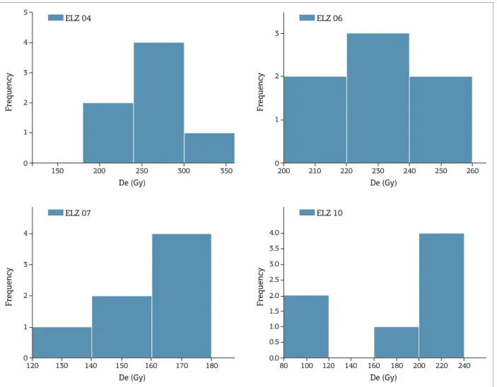
Sample U (ppm) Th (ppm) K (%) no/n De (Gy) AD (µGy/a) Age (ky) SAR
ELZ02 2.69 ± 0.55 7.12 ± 0.26 0.07 ± 0.01 12/7 232 ± 19 1931 ± 402 123 ± 7
ELZ03 6.26 ± 0.61 14.42 ± 0.52 - 12/7 149 ± 14 2708 ± 213 55 ± 7
ELZ04 2.34 ± 0.87 7.12 ± 0.26 0.49 ± 0.07 12/7 235 ± 47 3002 ± 406 89 ± 12
ELZ06 0.25 ± 0.03 2.62 ± 0.09 - 12/7 233 ± 16 972 ± 218 240 ± 16
ELZ07 0.61 ± 0.05 2.29 ± 0.08 - 12/7 166 ± 33 895 ± 96 176 ± 19
ELZ10 2.99 ± 0.80 11.62 ± 0.42 3.06 ± 0.44 12/7 192 ± 41 1765 ± 264 120 ± 7
ELZ11 0.59 ± 0.03 3.74 ± 0.13 - 12/7 112 ± 25 890 ± 143 172 ± 18
ELZ 27 1.87 ± 0.06 6.63 ± 0.14 0.61 ± 0.01 12/7 132 ± 12 1842 ± 17 74 ± 6.7
ELZ 28 1.64 ± 0.05 7.02 ± 0.17 0.40 ± 0.01 12/10 102 ± 9 1592 ± 15 66 ± 5.8
ELZ 30 1.73 ± 0.06 11.00 ± 0.28 0.010 ± 0.001 12/7 126 ± 9 1564 ± 18 86 ± 5.8
ELZ 38 1.27 ± 0.05 6.30 ± 0.11 1.20 ± 0.02 12/8 112 ± 11 2262 ± 18 51 ± 5
ELZ 79 1.34 ± 0.07 2.11 ± 0.07 - 24/16 12.0 ± 0.5 755 ± 233 15.9 ± 5.5
ELZ 80 1.26 ± 1.14 2.96 ± 0.10 - 24/20 8.0 ± 0.4 798 ± 305 10.0 ± 4.3
ELZ 82 1.22 ± 0.86 1.82 ± 0.06 0.34 ± 0.04 24/24 11 ± 0.5 1047 ± 278 10.5 ± 3.3
ELZ 83 1.31 ± 0.62 1.71 ± 0.06 - 24/18 3.0 ± 0.2 716 ± 165 4.2 ± 1.2
ELZ 84 1.25 ± 0.54 2.59 ± 0.09 - 24/20 14.0 ± 0.7 766 ± 145 18.3 ± 4.4
ELZ 88 1.4 ± 0.80 1.96 ± 0.07 - 24/20 11.0 ± 0.6 782 ± 212 14.0 ± 4.5
ELZ 89 1.06 ± 0.67 1.64 ± 0.06 0.006 ± 0.001 24/18 12.5 ± 0.7 656 ± 182 19.1 ± 6.3
ELZ 90 0.79 ± 0.46 1.66 ± 0.06 - 24/21 18 ± 0.9 581 ± 122 30.9 ± 8.0
ELZ 91 1.03 ± 0.37 0.59 ± 0.02 0.005 ± 0.001 24/15 13.5 ± 0.7 567 ± 96 23.8 ± 5.2
ELZ 93 1.93 ± 0.40 4.27 ± 0.15 0.67 ± 0.09 12/11 4 ± 0.2 1760 ± 216 2.3 ± 0.4
ELZ 94 3.11 ± 0.11 1.30 ± 0.69 - 12/12 6 ± 0.3 820 ± 189 7.3 ± 2.0
ELZ 97 0.54 ± 0.07 0.78 ± 0.03 - 12/9 6 ± 2 3078 ± 281 2.0 ± 1.0
Table 1. Concentrations of radioactive isotopes, equivalent dose, annual dose rate, and ages through the single aliquot regenerative protocol.
SAR: single aliquot regenerative protocol; De: equivalent dose; Adc.r: annual dose rate.
Franzinelli & Igreja (2011), limiting the Careiro-Island mar-gins at the Solimões-Amazon system channel. Moreover, the intersections of lineaments make up many rhombohedral basins, resembling the grabens of Paciência and Careiro described by Franzinelli & Igreja (2011) and Igreja (2012), which accommodated part of the Holocene sediments in the Solimões River channel on the studied reach.
As observed by radar images, the N40-55E lineaments control part of the right margin of the Solimões-Amazon system in the studied extent, and they are linked to the direction of lotic water bodies in the alluvial plain. On the other hand, the N50-65W lineaments are majorly responsi-ble for inlecting the secondary plain channels through short segments (Fig. 9), thus increasing the hydraulic gradient and forming limits of linear lakes in those rivers. Two less prominent directions, N65-75E and E-W, represent scat-tered smaller lineaments in the alluvial plain and control third-order drainages.
Additionally, the direction control of the right banks of Solimões River associated with the pattern of bypasses of the secondary plain channels suggests the predominance of a dextral kinematic related to the NE, NW and E-W struc-tures, as can be seen in Fig. 9.
DISCUSSION
Evolution of the Solimões-Amazon
fluvial system in the Quaternary
Large scale scroll bars and IHS depositional morphology preserved in the alluvial plain on the studied reach of the Solimões-Amazonas system, besides the record of at least ive paleochannels with tens of kilometers, which truncate
the luvial terraces upstream the studied area (Mertes et al.
F
requency
5
4
3
2
1
0
150 200 250 300 350 De (Gy)
ELZ 04
F
requency
4
3
2
1
0
130
120 140 150 160 170 180 De (Gy)
ELZ 07
F
requency
3
2
1
0
200 210 220 230 240 250 260 De (Gy)
ELZ 06
F
requency 2.0
2.5 3.0 3.5 4.0
1.5
1.0
0.5
0.0 100
80 120 140 160 180 200 220 240 De (Gy)
ELZ 10
Figure 3. Histograms of luvial terraces older level ages (single aliquot regenerative – SAR protocol).
resumption of the sedimentation in the Solimões-Amazon luvial system. he combination of these features supports the hypothesis of a meandering pattern prevalence in the past, despite the currently anabranching style.
The term anabranching was assumed in the present work to refer to the currently pattern of the studied extent of Solimões-Amazon luvial system due to the occurrence of many secondary meandering channels, difering from regular anastomosed rivers, which are laterally stable (Smith & Putman 1980) and with no major secondary contribu-tion of channels. In addicontribu-tion, Nanson & Knighton (1996) emphasize the anastomosed pattern to be limited to a spe-ciic low energy branch-channeled subset that is very often associated with ine-grained sediments deposition and the presence of organic matter, difering from the studied river reach, which presents some luvial pattern variations and a relevant presence of sandy sediments.
Latrubesse & Franzinelli (2002) proposed the possi-ble prevail of a secondary meandering system of channels
forming the older loodplain of Solimões River during the
Late Pleistocene; however, they attributed the 14C 1,030 ±
50 and 310 ± 50 years-dated younger scroll bars formation to the modern anastomosed pattern, thus they did not
deter-mine the exact point of change. More recently, Rozo et al.
(2012), based on OSL data, airmed that the anastomosed style has already been consolidated around 7,500 ± 850 and 3,400 ± 600 years, thus forming the islands complexes on the main channel of the Amazon River, while the develop-ment of the scroll bars on the alluvial plain was due to the secondary meandering channels activity.
Considering the OSL data attained in the present work, the development of the Quaternary luvial terra-ces in the studied reach of the Solimões-Amazon system may have started linked to a meandering river around 240,000 ± 16,000 ago. his fact is corroborated by OSL
maximum 204,600 ± 54,600 years recorded by Fiore et al.
Figure 4. Upper terrace outcrop covered by a thick clay soil layer in let margin of BR-319 road, near Careiro-Castanho city. Internally, the unit contains sand and mud intercalated layers showing inclined heterolithic stratiication.
Figure 5. Sequence of smooth undulations and valleys on MamoriLake let brim, showing the preservation of old
point bars with inclined heterolithic stratiication features making up the typical morphology of the Upper Terrace.
he meandering luvial pattern was probably developed with a high sinuosity single-channel and strong lateral migration that is usual to this type of rivers, as described
by Riccomini et al. (2000). Soares (2007) suggested the
low stability of the Solimões-Amazon riverbanks enabled the intense lateral migration of the meandering channel during the Upper Pleistocene, due to the low aggradation rates caused by sea level decrease and low subsidence rates
(Wright & Marriott 1993 and Zhang et al. 1997). In this
way, Irion et al. (1997) recorded a decrease of sea level,
between 120,000 and 18,000 years ago.
At some point in Early to Middle Holocene (sensu Walker
et al. 2012), the luvial system began a gradational change
to the present anabranching pattern, with secondary con-tribution of channels, due to the combination of the regio-nal base level rise, the environmental changes during the Holocene, and the tectonic action (Soares 2007).
he regional base level change is probably associated with
the blockage of the Amazon river outlow (Irion et al. 1997,
Soares 2007) caused by a global gradual sea level rise, which started at the end of Upper Pleistocene related to the begin-ning of the current interglacial age. he sea level arrived its
largest global mark at the Middle Holocene (sensu Walker
et al. 2012), around 6,000 to 5,000 years BP, as recorded
by Vieira (1981), Irion et al. (1997), Mörner (2005), and
Rossetti et al. (2005).
A
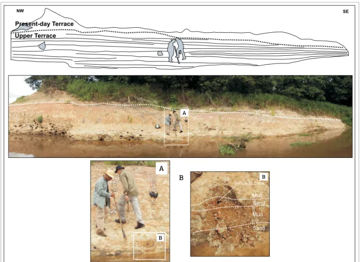
Figure 6. Intercalations of ine sand and mud layers forming inclined heterolithic stratiication on the Upper Terrace outcrop located at the right margin of the Paraná Comprido. The older deposit is partially covered by a present-day terrace formed as the result of recent evolution of the tributary river.
NW SE
Present-day Terrace
Upper Terrace
SE
A
A
B
B
Sample ELZ 02A
Mud Sand
Mud
Sand
Thus, the gradual base level rise associated with the tilting of tectonic blocks southward the Solimões-Amazon alluvial plain suggested by Soares (2007), led to the generation of accommodation space and consequent
increase of channel-bed aggradation (Zhang et al. 1997,
Blum & Törniqvist 2000). hese factors were involved in the reduction of channel low velocity and increment of suspended ine sediments load, leading to the deve-lopment of more cohesive riverbanks, thus restricting the migration of the meander channel and favoring the stabilization of the river course, a remarkable feature of anabranching rivers.
In addition, Wright & Marriott (1993) pointed out that luvial systems are substantially variable and respond even to low intensity climatic and tectonic changes. hus, approxi-mately at the same time the sea level reached its largest mark in Holocene palynological, evidence showed the increasing rates of humidity in Central Amazon around 5,000 to 4,000
years ago (Latrubesse & Franzinelli 1993, Baker et al. 2001
and Rossetti et al. 2005). In this sense, Behling et al.
(2010) and Behling (2011) remarked increment phases of
varzea and Igapó vegetation at 4,610 and 2,060 years BP, favoring the phytostabilization of the riverbanks and conse-quent major contribution of more cohesive ine sediments in the suspended load.
The neotectonics probably developed a secondary role in the fluvial pattern shift, enabling the accom-modation of the Holocene sediments at Paciência, Manaus and Careiro rhombograbens (Franzinelli & Igreja 2011, Igreja 2012) in the Solimões-Amazonas River floodplain and Tubinambarana lineament (Costa
et al. 1996), which fits the Madeira River and its fluvial terraces. Igreja (2012) registered sedimentation rates varying from 2 to 7 mm per year in Careiro Island in
the last 2,840 years, whereas Rozo et al. (2012)
recor-ded 1.1 mm per year over the last 7,500 years, confir-ming the tendency of space generation by subsidence in the basin. Additionally, Soares (2007) suggested the
A A
B
A
SW NE
B
A
B B
Figure 7. Typical relief of Intermediate Terrace surface, sectioned by a tributary river. A and B show details of the river margin composed by brown massive silt-clay sediments.
SW NE
A
Mud
Sand Mud
Sand Sand
Mud
A
Sample ELZ 83A Sand Mud
Sand Mud
Figure 8. Lower Terrace outcrop on Solimões River right brink showing the front face of a point bar constituted by intercalations of mud (dark grey) and sand (light grey) metric layers. (A) Detail of layers forming the inclined heterolithic stratiication, and the site of sampling to optically stimulated luminescence analysis.
A
A
B
B
A
tectonic blocks basculation as one of the causes of pro-gressive abandon of the Solimões-Amazon system floo-dplain from South to North.
The OSL data found related to the lower terrace deposits suggest that the beginning of the sedimenta-tion became the predominance of a meandering flu-vial system at the end of Upper Pleistocene. However, given the environmental changes and subsidence action recorded in the Holocene, it is reasonable to assume that part of the development of this geomorphological unit occurred during a gradual transition period, from the meandering pattern to the current anabranching, which was probably concluded around 7,000 to 6,000 years ago, with the maximum regional base level cau-sed by the sea level rise. Thereby, the point bar deposits younger than 7,300 ± 2,000 OSL ages are considered results from the secondary channels of an anabranching river, corroborating the fluvial dynamics proposal by
Rozo et al. (2012).
Evolution model of
Quaternary fluvial terraces
Subsidence phase on the basin floor (Rossetti et al.
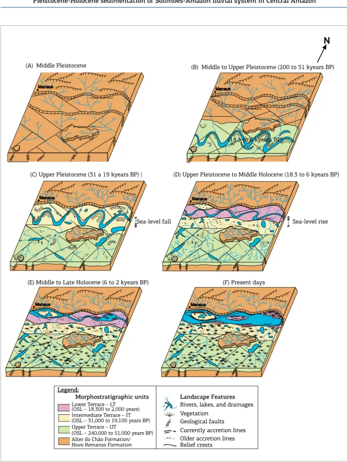
2005, Soares 2007) enabled the initial deployment of the Solimões-Amazon luvial system hundreds of kilometer sou-thward from the current main channel (Fig. 10A). Attained OSL ages suggest the beginning of the UT sedimentation at 240,000 ± 16,000 years ago, at the end of the Middle Pleistocene, extending until the Upper Pleistocene at 51,000 ± 5,000 years ago (Fig. 10B).
Afterwards, the increasing displacement of the basin South brim (Soares 2007) associated with the regional base level drop caused by the sea level fall in the Late Pleistocene (Irion et al.
1997), aforded the northward luvial system continuous late-ral migration, thus developing the IT level between 30,900 ± 8,000 and 19,100 ± 6,300 years ago (Fig. 10C).
he northward meandering luvial system progress was interrupted, and its sinuosity started to decrease when the main channel reached a resistant and elevated obstacle represented
Madeirinha ‘Paraná’
Janaucá Lake MamoriLake
Castanho-Mirim ‘Paraná’
Castanho Lake
Castanho River
N
9560000
9570000
9580000
9560000
190000 200000 210000
190000
100000 110000 120000 130000 140000 130000 140000 150000
130000 140000 150000
100000 110000 120000 130000 140000
200000 210000
9570000
9580000
9570000
958000
9590000
9600000
9570000
9610000
9620000
9610000
9620000
958000
9590000
9600000
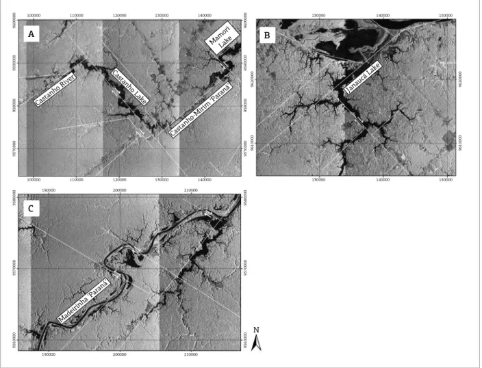
Figure 9. Fluvial capture features on CastanhoRiver (A), Janauacá Lake (B), and Paraná Madeirinha(C). Sets of sub-rectangular pattern of drainages prevails on the study area aforded by NE and NW (orthogonal) lineaments trend.
A
C
by clifs of Alter do Chão and Novo Remanso Formations sited between Manacapuru and Itacoatiara regions, develo-ping the LT between 18,300 ± 4,400 and 7,300 ± 2,000 years ago (Fig. 10D). he point bars younger than 7,300 ±
Present days
Middle to Upper Pleistocene (200 to 51 Kyears BP) (B)
Upper Pleistocene (31 a 19 Kyears BP)
( C) (D)Upper Pleistocene to Middle Holocene (18.3 to 6 Kyears BP)
(F)
N
Middle Pleistocene (A)
Middle to Late Holocene (6 to 2 Kyears BP) (E)
Manaus Manaus
Sea-level rise Sea-level fall
Legend:
Alter do Chão Formation /Novo Remanso Formation
Upper Terrace - UT
(OSL - 240.000 to 51.000 years BP) Intermediate Terrace - IT (OSL - 31.000 to 19.100 years BP) Lower Terrace - LT
(OSL - 18.300 to 2.000 years BP)
Morphostratigrafic units
Rivers, lakes and drainages Vegetation
Geological faults Currently acretion lines Older acretion lines Relief crests
Landscape features
Manaus Manaus
Manaus Manaus
Sea-level fall
(18.3 to 6 kyears BP)
(E) Middle to Late Holocene (6 to 2 kyears BP) (F) Present days
Legend:
Morphostratigraphic units
Lower Terrace – LT (OSL – 18,300 to 2,000 years) Intermediate Terrace – IT (OSL – 31,000 to 19,100 years BP) Upper Terrace – UT
(OSL – 240,000 to 51,000 years BP) Alter do Chão Formation/ Novo Remanso Formation
Landscape Features
Rivers, lakes, and drainages Vegetation
Geological faults Currently accretion lines Older accretion lines Relief crests
Sea-level rise (A) Middle Pleistocene (B) Middle to Upper Pleistocene (200 to 51 kyears BP)
(C) Upper Pleistocene (31 a 19 kyears BP) | (D) Upper Pleistocene to Middle Holocene (18.3 to 6 kyears BP)
Figure 10. Landscape evolution model diagrams from the Pleistocene until the present days.
In the last 2,000 years, the Solimões-Amazon luvial sys-tem, between the Negro and Madeira rivers tributaries, has showed a well stable anabranching pattern with low rates of channels migration (Mertes et al. 1996, Rozo et al. 2005; 2012,
Passos et al. 2012). he consistency of the younger luvial bars
top is corroborated for 14C ages up to 2,800 BP attained by
Sternberg (1960), dating Native American ceramics and Absy (1979) organic matter. Nowadays, the Solimões-Amazon system truncates and reworks the IT and the LT deposits (Fig. 10F), favoring the development of unconsolidated sandy bars within the main channel and forming elongated islands.
CONCLUSIONS
he present study enabled the establishment of a relation between the morphostratigraphic sequence evolution and the reassembly of the Solimões-Amazon river in the extent between Negro and Madeira tributaries activity in the last 240,000 years. OSL indings have showed the beginning of sedimentation in the Solimões-Amazon luvial system loo-dplain from the Middle to Upper Pleistocene. hey also evi-denced a Northward main channel migration trend, leaving behind, for a hundred kilometers, three terraces levels mos-tly formed by diferent proportioned mud and sand interca-lated layers, representing IHS pairs in old point bars. his fact suggests the prevailing of the meandering luvial style
Absy M.L. 1979. A palynological study of Holocene sediments in the Amazon Basin. PhD Thesis, University of Amsterdam, Amsterdam, 100 p. Baker P.A., Seltzer G.O., Fritz S.C., Dunbar R.B., Grove M.J., Tapi P.M., Cros L.S., Rowe H.D., Broda J.P. 2001. The history of South America precipitation for the past 25,000 years. Science, 291(5504):640-643. Behling H. 2011. Holocene environmental dynamics in coastal, eastern and central Amazonia and the role of the Atlantic sea-level change. Geographica Helvetica, 66(3):208-216.
Behling H., Bush M.B., Hooghiemstra H. 2010. Biotic development of Quaternary Amazonia: a palynological perspective. In: Hoorn C. & Wesselingh F.P (eds.) Amazonia: landscape and species evolution. A look into the past. Oxford, Wiley-Blackwell Publishing Ltd., p. 335-345. Blum M.D. & Törnqvist T.E. 2000. Fluvial responses to climate and sea-level change: a review and look forward. Sedimentology, 47(1):2-48. Costa J.B.S., Bemerguy R.L., Hasui Y., Borges M.S., Ferreira Junior C.R.P., Bezerra P.E.L., Costa M.L., Fernandes J.M.G. 1996. Neotectônica da região amazônica: aspectos tectônicos, geomorfológicos e deposicionais. Geonomos, 4(2):23-44.
Dantas M.E. & Maia M.A.M. 2010. Compartimentação geomorfológica. In: Maia M.A.M & Marmos J.L. (org.) Geodiversidade do estado do Amazonas. Manaus, Serviço Geológico do Brasil-CPRM, p. 27-44.
REFERENCES
Dino R., Soares E.A., Riccomini C., Antonioli L., Nogueira A.C.R. 2006. Caracterização palinoestratigráica de depósitos miocênicos da bacia do Amazonas, região de Manacapuru, AM. In: VII Simpósio do Cretácio do Brasil Cretáceo, I Simpósio do Terciário do Brasil, Serra Negra, Anais, p. 43.
Dino R., Soares E.A., Antonioli L., Riccomini C., Nogueira A.C. 2012. Palynostratigraphy and sedimentary facies of middle miocene luvial deposits of the Amazon Basin, Brazil. Journal of South American Earth Sciences, 34:61-80.
Fernandes Filho L.A. 1996. Geologia, Mineralogia e Geoquímica dos Lateritos de Manaus-Amazon. MS Dissertation, Instituto de Geociências, Universidade Federal do Pará, Belém, 96 p.
Fiore M., Soares E.A.A., Mittani J.C.R., Yee M., Tatumi S.H. 2014. OSL dating of sediments from Negro and Solimões rivers – Amazon, Brazil. Radiation Physics and Chemistry, 95:113-115.
Franzinelli E. & Igreja H.L.S. 1990. Utilização do sensoriamento remoto na investigação da área do baixo Rio Negro e grande Manaus. In: VI Simpósio Brasileiro de Sensoriamento Remoto, Manaus, Anais, v. 3, p. 641-648. Franzinelli E. & Igreja H.L.S. 2011. Ponta das Lajes e o Encontro das Águas, AM – A Formação Alter do Chão como moldura geológica do espetacular Encontro das Águas Manauara In: Winge M., Schobbenhaus C., Souza C.R.G., Fernandes A.C.S., Berbert-Born M.,
throughout the Upper Pleistocene, corroborated by the kilo-metric paleochannel features truncating the luvial terraces. Since the Middle Holocene until nowadays, the gradual conversion from the meandering to the current anabranching system has been happening, due to the increase of the regio-nal base level caused by the sea level rise registered from the Upper Pleistocene to the Middle Holocene. It is associated with the environmental changes in the past 7,000 to 6,000 years in Amazon that were driven by the increasing humi-dity rates and consequent development and expansion of the rain forest, therefore providing the stabilization of river banks and, ultimately, the tectonic features, represented by rhombograbens that enabled the Holocene sedimentation in the Solimões-Amazon current river course.
ACKNOWLEDGMENTS
he inancial support was provided by Fundação de
Amparo à Pesquisa do Estado do Amazonas (FAPEAM)
through the project: “Estudo Sedimentológico e Estratigráico
Sallun Filho W., Queiroz E.T. (eds.) Sítios Geológicos e Paleontológicos do Brasil. Brasília, Serviço Geológico do Brasil-CPRM, 3, 332 p. Available at: <http://sigep.cprm.gov.br/sitio054/sitio054.pdf>. Accessed in Jan. 2016.
Gonçalves Junior E.S., Soares E.A.A., Tatumi S.H. 2014. Terraços luviais Quaternários do sistema Solimões-Amazon ao sul de Manaus. In: 47° Congresso Brasileiro de Geologia, Salvador, Anais, CD-ROM.
Igreja H.L.S. 1998. Aspectos do modelo neotectônico na Placa Sul-Americana na Província Estrutural Amazônica, Brasil. Thesis, Universidade Federal do Amazonas, Manaus, 155 p.
Igreja H.L.S. 2012. A neotectônica e as mudanças hidrogeológicas do sistema luvial Solimões-Amazon: “Encontro das águas de Manaus – EAM” – Amazon, Brasil. Revista Geonorte,Edição Especial, 2(4):20-33.
Igreja H.L.S., Franzinelli E., Repolho T. 1999. Neotectonic inluence on luvial capture in the Amazon Basin, state of Amazon, Brazil. In: GLOCOPH ’98 conference, Kumagaya, Science Reports of Tohoku University, v. 49(2), p. 197-206.
Irion G., Junk W.J., Nunes de Mello J.A.S. 1997. The large central Amazonian rivers loodplain near Manaus: geological, climatological, hydrological and geomorphological aspects. In: Junk W.J. (eds.) The
central Amazon loodplains: ecology of a pulsing system. Berlin, Spring Verlag, p. 23-46.
Kistler P. 1954. Historical resume of the Amazon Basin. PETROBRAS/ RENOR, Belém, Relatório Interno.
Latrubesse E.M. & Franzinelli E. 1993. Reconstrução das condições hidrogeológicas do passado. Ciências Hoje, 16(93):40-43.
Latrubesse E.M. & Franzinelli E. 2002. The Holocene alluvial plain of the middle Amazon River, Brazil. Geomorphology, 44(3):241-257. Latrubesse E.M. 2008. Patterns of anabranching channels: The ultimate end-member adjustment of mega rivers. Geomorphology, 101:130-145.
Mertes L.A.K, Dunne T., Martinelli L.A. 1996. Channel-loodplain geomorphology along the Solimões-Amazon River, Brazil. Geological Society of American Bulletin, 108(9):1089-1107.
Mörner N.A. 2005. Changing sea-levels. In: Schwarts L.M. (eds.) Encyclopedia of coastal science. Dordretch, Spring, p. 229-233.
Murray A.S. 1981. Environmental radioactivity studies relevant to thermoluminescence dating. PhD Thesis, Oxford University, Oxford, 391 p. Murray A.S & Wintley A.G. 2003. The single aliquot regenerative dose protocol: potential for improvements in reliability. Radiation Measurements, 37:377-381.
Nanson G.C. & Knighton A.D. 1996. Anabranching rivers: their cause, character and classiication. Earth Surface Process and Landforms, 21:217-239.
Passos M.S., Soares E.A.A., Salazar C.A. 2012. Análise bitemporal do Rio Solimões no trecho entre Manacapuru e Manaus (Amazônia Central) por meio de imagens Landsat-5/TM. In: 43° Congresso Brasileiro de Geologia, Santos, Anais, CD-ROM.
Prescott J.R., Clay R.W. 2000. Cosmic ray dose rates for luminescence and ESR dating: measured with a scintillation counter. Ancient TL, 18:11-14. Riccomini C., Gianinni P.C.F., Mancini F. 2000. Rios e processos aluviais. In: Teixeira W., Toledo M.C.M., Fairchild T.R., Taioli F. (eds.) 2000. Decifrando a Terra. São Paulo, Oicina de Textos, 568 p. Riker S.R.L., Reis N.J., D’Antona R.J.G., Brito I.A. 2008. Projeto materiais de construção no domínio médio Amazona. In: Informe de Recursos Minerais, Série Rochas e MineraisIndustriais n° 3. Manaus, Serviço Geológico do Brasil-CPRM, 168 p., CD-ROM.
Rossetti D.F., Toledo P.M., Góes A.M. 2005. New geological framework for Western Amazonia (Brazil) and implications for biogeography and evolution. Quaternary Research, 63(1):78-89.
Rozo J.M.G. 2004. Evolução Holocênica do Rio Amazonas entre a Ilha do Careiro e a foz do Rio Madeira. Msc Thesis, Departamento de Geociências, Universidade Federal do Amazonas, Manaus, 93 p. Rozo J.M.G., Nogueira A.C.R., Carvalho A.S. 2005. Análise multitemporal do sistema luvial do Amazonas entre a Ilha do Careiro e a foz do Rio Madeira. In: XII Simpósio Brasileiro de Sensoriamento Remoto, Goiânia, Anais, p.1875-1882.
Rozo J.M.G., Nogueira A.C.R., Truckenbrodt W. 2012. The anastomosing pattern and the extensively distributed scroll bars in the middle Amazon River. Earth Surface Processes and Landforms, 37(14):1471-1488. Silva C.L., Morales N., Crósta A.P., Costa S.S., Jiménez-Rueda J.R. 2007. Analysis of tectonic-controlled luvial morphology and sedimentar processes of the Western Amazon Basin: an approach using satellite images and digital elevation model. Anais da Academia Brasileira de Ciências, 79(4):693-711.
Smith D.G. & Putnam P.E. 1980. Anastomosed luvial deposits: modern and ancient examples from Alberta, Canada. Canadian Journal of Earth Sciences, 17(10):1396-1406.
Soares E.A.A. 2007. Depósitos pleistocenos da região de conluência
dos rios Negro e Solimões, Amazonas. PhD Thesis, Instituto de Geociências, Universidade de São Paulo, São Paulo, 205 p.
Soares E.A.A., Tatumi S.H., Riccomini C. 2010. OSL age determinations of Pleistocene luvial deposits in central Amazonia. Anais da Academia Brasileira de Ciências, 82(3):14-19.
Sternberg H. 1960. Radiocarbon dating as applied to a problem of Amazonian morphology. In: XVIII Congress International de Géographic, Anais, v. 2, p. 399-424.
Tatumi H.S., Silva L.L., Pires E.L., Rossetti D.F., Góes A.M., Munita C.S. 2008. Datação de sedimentos pós-barreiras no norte do Brasil: implicações paleogeográicas. Revista Brasileira de Geociências, 38(3):514-524.
Teixeira S.G. & Soares E.A.A. 2011. Uso de imagens multi-sensores na identiicação de paleocanais na planície aluvial do Rio Solimões, Amazônia Ocidental. In: XIII Congresso da Associação Brasileira de Estudos do Quaternário – ABEQUA. Búzios, Anais, CD-ROM. Thomas R.G., Smith D.G., Wood J.M., Visser J., Calverley-Range E.A., Koster E.H. 1987. Inclined Heterolithic Stratiication – terminology, description, Interpretation and signiicance. Sedimentary Geology, 53(1-2):123-179. Vieira P.C. 1981. Variações no nível marinho: Alterações eustáticas no Quaternário. Revista Instituto de Geociências, 2(1):39-58. Walker M.J.C., Berkelhammer M., Björck S., Cwynar L.C., Fisher D.A., Long A.J., Lowe J.J., Newnham R.M., Rasmussen S.O., Weiss H. 2012. Formal subdivision of the Holocene Series/Epoch: a Discussion Paper by a Working Group of INTIMATE (Integration of ice-core, marine and terrestrial records) and the Subcommission on Quaternary Stratigraphy (International Commission on Stratigraphy). Journal of Quaternary Science, 27(7):649-659.
Wright V.P., Marriott S.B. 1993. The sequence stratigraphy of luvial depositional systems: The role of loodplain sediments storage. Sedimentary Geology, 86:203-210.
Zhang Z., Sun K., Yin J. 1997. Sedimentology and sequence stratigraphy of the Shanxi Formation (Lower Permian) in the northwestern Ordos Basin, China: an alternative sequence model for luvial strata. Sedimentary Geology, 112:123-126.