1Faculdade de Geologia, Universidade Federal do Pará – UFPA, Belém (PA), Brazil. E-mail: [email protected]
2Departamento de Geociências, Universidade Federal do Amazonas – UFAM, Manaus (AM), Brazil. E-mail: [email protected]
*Corresponding author.
Manuscript ID: 20160066. Received in: 05/19/2016. Approved in: 05/20/2016. ABSTRACT: he development of the transcontinental Amazon Ri-ver System involved geological events in the Andes Chain; Vaupés, Purus and Gurupá arches; sedimentary basins of the region and sea level changes. he origin and age of this river have been discussed for decades, and many ideas have been proposed, including those pertai-ning to it having originated in the Holocene, Pleistocene, Pliocene, Late Miocene, or even earlier times. Under this context, the geology of the sedimentary basins of northern Brazil has been analyzed from the Mesozoic time on, and some clariications are placed on its stratigra-phy. Vaupés Arch, in Colombia, was uplifted together with the Ande-an Mountains in the Middle Miocene time. In the Cenozoic Era, the Purus Arch has not blocked this drainage system westward to marine basins of Western South America or eastward to the Atlantic Ocean. Also the Gurupá Arch remained high up to the end of Middle Mioce-ne, directing this drainage system westward. With the late subsidence and breaching of the Gurupá Arch and a major fall in sea level, at the beginning of the Late Miocene, the Amazon River quickly opened its pathway to the west, from the Marajó Basin, through deep headward erosion, capturing a vast drainage network from cratonic and Andean areas, which had previously been diverted towards the Caribbean Sea. During this time, the large siliciclastic inlux to the Amazon Mou-th (Foz do Amazonas) Basin and its fan increased, due to erosion of large tracts of South America, linking the Amazon drainage network to that of the Marajó Basin. his extensive exposure originated the Late Miocene (Tortonian) unconformity, which marks the onset of the transcontinental Amazon River lowing into the Atlantic Ocean. KEYWORDS: Amazon River reversion; Headwater erosion; Torto-nian; Gurupá Arch.
RESUMO: O desenvolvimento do Sistema de drenagem do Rio Am-azonas envolveu eventos geológicos nos Andes; arcos de Vaupés, Purus e Gurupá; bacias sedimentares da região, assim como mudanças do nível do mar. A origem e a idade deste rio têm sido discutidas por décadas, e muitas ideias têm sido propostas, incluindo aquelas relacionadas a ele ter se originado no Holoceno, Pleistoceno, Plioceno, Neomioceno, ou mesmo antes. Nesse contexto, a geologia das bacias sedimentares do norte do Brasil foi analisada a partir da era Mesozoica, e alguns es-clarecimentos são colocados na sua estratigraia. O Arco de Gurupá permaneceu elevado até o Mesomioceno, direcionando o sistema de drenagem primeiro para o oeste e posteriormente para norte, sem ob-strução do Arco do Purus na Amazônia central. O Arco de Vaupés, na Colômbia, foi soerguido junto com as montanhas dos Andes no Mesomioceno, separando a drenagem do Caribe da do Rio Amazonas. Com a subsidência tardia e o brechamento do Arco do Gurupá e uma grande queda no nível do mar no início do Neomioceno, o Rio Amazo-nas abriu rapidamente seu caminho, de leste para oeste, a partir da Ba-cia do Marajó. Isto aconteceu através de erosão remontante profunda, que capturou a vasta rede de drenagem das áreas cratônicas e andinas, que anteriormente se desviara ao mar do Caribe. Durante esse tempo, o grande inluxo de siliciclásticos à Bacia da Foz do Amazonas e seu leque aumentou, em razão da erosão em vastas áreas da América do Sul, incorporando a rede de drenagem da Bacia do Marajó à drenagem amazônica. Essa exposição extensiva originou a discordância tortoni-ana que marca o estabelecimento do Rio Amazonas transcontinental em direção ao Oceano Atlântico.
PALAVRAS-CHAVE: Reversão Rio Amazonas; Erosão remontante; Tortoniano; Arco do Gurupá.
Eustatic and tectonic change efects
in the reversion of the transcontinental
Amazon River drainage system
Efeitos de mudanças eustáticas e tectônicas na reversão
do sistema de drenagem do Rio Amazonas transcontinental
Mario Vicente Caputo1*, Emilio Alberto Amaral Soares2
INTRODUCTION
In Brazilian Amazonia, geological data from wells and geophysical surveys initiated by the National Petroleum Council (Conselho Nacional de Petróleo – CNP), in 1939, and by Petrobras, in 1953, revealed three structural arches, which presented diverse ages and origins, while in Peruvian and Colombian Amazonia, other arches were also identi-ied. In Brazil, the Iquitos, Purus and Gurupá arches seg-mented the sedimentary area in the Upper, Middle and Lower Amazon basins, respectively (Morales 1957, 1959). According to this author, the Iquitos Arch separates the Acre and Andean Foreland basins from the Solimões Basin (formerly denominated Upper Amazon Basin); the Purus Arch separates the Solimões and Amazon basins (designated Middle Amazon Basin); and the Gurupá Arch separates the latter from the Marajó Basin (denominated Lower Amazon Basin) (Schobbenhaus et al. 2004).
Gurupá Arch is the shoulder of the Marajó rift that formed in the early phases of the Central Atlantic Ocean opening, in the Early Cretaceous time (Caputo 2012). Purus Arch resulted from a Middle Proterozoic graben in central Brazil, with an approximate north-south direction, which crossed the Amazonian basin area and reversed in the Late Proterozoic, becoming an exposed high up to the Mississippian time (Wanderley Filho 1991).
he Iquitos Arch resulted from a Neogene periph-eral isostatic forebulge brought about by the Andean chain overloading on the South-American Plate west-ern edge (Caputo 1985a,b, 1991, 2012, Roddaz et al. 2005, Caputo & Silva 1990). his arch, with a NW-SE direction, has remarkable expression in Peru, but is less visible in Brazil, where it has been inferred in several positions, being for this reason diicult to determine its actual location. Nevertheless, this arch does not separate the Acre and Andean foreland basins from the Solimões Basin in Brazil, being this separation accomplished by the Envira Arch, formed by the Late Jurassic Juruá Orogeny (Caputo 2014).
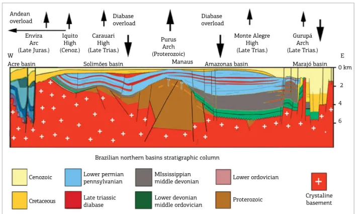
In addition to the mentioned arches, highs are also described in the basins of northern Brazil. he Monte Alegre Dome, with an area of 20 by 30 km, does not segment the Amazon Basin, having local character in the Amazon Basin’s Northern Platform, and its genesis is likely related to Mesozoic basic intrusions. he Carauari High subdivides the Solimões Basin in the sub-basins of the Juruá (East) and Jandiatuba (West), and its genesis is related to an iso-static peripheral forebulge of a thick diabase sill (upper sill; Fig. 1). Vaupés Arch, in Colombia, a transversal feature to the Andes, was formed with the Andean uplift in the Middle Miocene (Mora et al. 2010), caused by the Nazca and South-American plates collision.
Crystaline basement Andean
overload Diabaseoverload Diabaseoverload Envira
Arc (Late Juras.)
Iquito High (Cenoz.)
Carauari High (Late Trias.)
Purus Arch (Proterozoic)
Monte Alegre High (Late Trias.)
Gurupá Arch (Late Trias.) W
Acre basin Solimões basin Manaus Amazonas basin Marajó basin E 0 km 2 4 6
Brazilian northern basins stratigraphic column Cenozoic
Cretaceous
Lower permian pennsylvanian Late triassic diabase
MIssissippian middle devonian Lower devonian middle ordovician
Lower ordovician Proterozoic
Figure 1. The Schematic longitudinal section of the Acre, Solimões, Amazon and Marajó basins shows structural
Tectonic activity of structural highs and arches was fun-damental in directing the northern South-American drainage network, while sea level changes inluenced on sedimentation (continental and marine) and erosion in sedimentary basins.
AMAZONIA STRUCTURAL
ARCHES GENESIS AND
PALEOGEOGRAPHY GURUPÁ ARCH
AND NEIGHBORING AREAS
Paleozoic Amazon and Parnaíba basins were connected between themselves and the Paleozoic basins of northwestern Africa (Taodeni and Accra basins), with marine ingressions originated through that continent. In Accra Basin (Ghana), in onshore and ofshore regions, the Paleozoic column pres-ents the same stratigraphy and glacial evpres-ents as that of the Parnaiba basin, up to the Carboniferous (Caputo 1984a). Gondwana and Laurasia continents amalgamation in the Mississippian time caused the North African Paleozoic basins to uplift and close, bringing about the Amazon Basin’s marine sedimentation discontinuity. Only in Pennsylvanian did the sea enter again, coming from the West, through the Solimões Basin and Purus Arch. In the Permian, the sea retreated from the area towards the coastal marine basins of Western South America (Caputo 1984a).
In the Triassic time, an intercontinental drainage sys-tem linked the current high Sahara region (Africa) to the western portion of South America, where correlative sedi-ments were deposited. his would be the irst intercontinen-tal Amazon River. At the inal stage of the Triassic Period, a thermal uplifting, at the junction between these conti-nents (Aires 1985), broke the continuity of that drainage, being that the portion which remained in South America, from the east end of the Amazon Basin, would have kept its course westwards, constituting the irst transcontinental Amazonian drainage. he aforementioned uplifting caused widespread erosion and may be connected to a hot spot, since data from gravimetric modeling conducted by Aires (1985) suggested crustal replacement for denser mantle mate-rial to have occurred in the Marajó region, when the North Atlantic Ocean rifting took place. he continental crust was thinned and heated, causing it to arch and rise along with the Paleozoic sedimentary package of the Amazon Basin east-ern end (Fig. 2). Extensive old NW cratonic fractures were reactivated and illed with diabase during the basic intru-sions of Penatecaua Formation, which presented its largest number of fractures in this direction (Fig. 3), according to geological data from the Amapá State cratonic area (Villegas 1994, Costa et al. 2002).
Probably, from the Jurassic began to take place the most posi-tive trend of uplift of the Marajó region. Its climax occurred in the
BASEMENT GURUP
Á ARCH
ENE Amazon basin
WSW
Graben Negative flower
Gurupá Arch
Time in seconds
0.0
1.0
2.0
Alter do chão Fm.
Pre-cenozoic unconformity Paleozoic
Basement
0 20 km
BASEMENT GURUP
Á ARCH
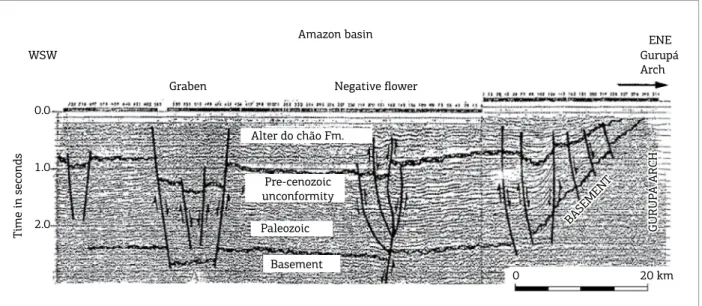
Figure 2. Seismic geological section of Gurupá Arch, where the basement still remains elevated, at the Amazon Basin’s eastern end. This high hindered the Amazon and Solimões basin eastward drainage and directed it at irst
westward and later, with the construction of the Andes, northward toward the Caribbean Sea. The horizontal
Early Cretaceous with the rupture of the Gondwana Continent and the formation of the Central Atlantic Ocean and the Marajó rift, the shoulder of which constituted the Gurupá Arch (Fig. 1), situated near the new ocean coast (Zalán & Matsuda 2007).
his arch became a watershed between the Amazon and Marajó basins (Fig. 2). he latter basin consists of an assem-blage of genetically related taphrogenic sub-basins (Figs. 1 and 3), formed on the Brasiliano-Pan African Araguaia and
4ºN
2ºN
0º
2ºS
4ºS
52ºW 50ºW 48ºW 46ºW
Marajó Basins System Phanerozoic Sedimentary cover Mesozoic diábase dique
Precambrian crystalline basement and orogenic/shear belts
Mexiana sub-basin Limoeiro sub-basin Cametá sub-basin Mocajuba sub-basin
Strike slip fault Normal fault Inverse fault Arch Isobath (m)
N
0 100 km
Gurupi belts (Zalán & Matsuda 2007, Costa et al. 2002). he oldest Mesozoic layers drilled in this region show to be as old as Barremian, but seismic sections indicate signiicant presence of older Mesozoic beds.
he rifting, which gave rise to the Marajó Basin, at the Early Cretaceous, caused independent sedimentation from the Amazon Basin. he Marajó Basin has many ainities and formations common to the Grajaú (Parnaíba Basin) and Foz do Amazonas basins (Zalán & Matsuda 2007, Santos & Rossetti 2006, Rossetti & Valeriano 2007, ANA 2015).
Following the opening of the Amazon Basin (Cuminá Event) in the beginning of the Paleozoic, the Gurupá tec-tonism was the most expressive tectonic event, since it deinitely destroyed the Amazon Basin’s physical continu-ity with the Parnaíba and northwestern Africa basins, and uplifted its eastern Pre-Ordovician basement during the rupture of the Gondwana Continent (Caputo et al. 1983, Caputo 1984a, 2012).
he continental crust stretching was not enough to break up the continental plate and form an oceanic crust on the Marajó Basin loor. he Gurupá Arch uplift brought about the erosion of over 5,000 m of Paleozoic strata and diabase sills, as well as Pre-Ordovician rocks of unknown thickness. Remnants from Amazon and Parnaiba basins’ Paleozoic strata were preserved on Marajó rift (Caputo 1984a, Zalán & Matsuda 2007), indicating their preterit continuation with the Parnaíba and African basins. On the west edge of this rift, by the Gurupá Arch, occurred sedimentation of fan-glomerates (Jacarezinho Formation), resulting from debris lows along a steeped faulted zone, similar to what occurred with the Salvador Formation in the Recôncavo Basin (Bahia State), throughout the rift stage, indicating a high relief on this border. At the end of the Albian, occurred an interrup-tion in the sedimentainterrup-tion that lasted near 3 Ma, with the closing of the rift stage (Zalán & Matsuda 2007). With the return of the sedimentation in the post-rift stage there was an expansion of the deposional site, with sediments over-lapping deposits from the rift stage and the basement por-tion of the adjacent Amapá and Ponta de Pedras platforms (Fig. 3) from the end of the Albian onwards (Galvão 2004, Zalán & Matsuda 2007).
he Gurupá Arch did not apparently subside completely due to the thermal decay that should normally take place 40 Ma following the rifting, because other tectonic forces also began to work in the area. During the subsidence and deposition in the post-rift stage of the Marajó Basin, uplifting in the area of the arch occurred, suggesting a possible tec-tonic decoupling between the arch and taphrogenic basins, from the Albian onwards. While subsidence and deposition continued in the Marajó Basin up to the Quaternary, with few sedimentation breaks, subsidence ceased for a long time
on other Brazilian coast’s aborted Cretaceous rifts (Tacutu, Bragança-Vizeu, Araripe, Jatobá, Tucano and Recôncavo). Marajó Basin and Gurupá Arch presented an anomalous behavior as to subsidence when compared with other men-tioned rifts.
From the Cretaceous, the Marajó Basin deposition had continuity with the Grajaú Basin (Parnaíba) equivalent for-mations, represented by Codó, Itapecuru, Ipixuna, Pirabas, Barreiras and Post-Barreiras formations (Santos & Rossetti 2006, Zalán & Matsuda 2007, Figueiredo et al. 2007).
Cretaceous and Cenozoic sediments presented a quite signiicant amount of Braziliano zircon minerals in the Foz do Amazonas Basin (Jorge de Jesus Picanço de Figueiredo, personal communication, 2015), indicating a different source than that of the rocks of the Amazon River Valley.
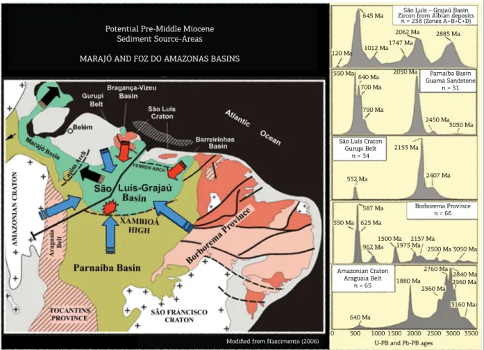
he presence of abundant Brasiliano-aged and older zircon minerals in the Itapecuru Formation suggests, for Marajó Basin, a major sediment source from tectonostrati-graphic terranes of Araguaia and Gurupi Brasiliano belts, and older rocks recycled from Parnaíba Basin, Borborema and Maroni-Itacaúnas Provinces (Fig. 4) (Nascimento 2006). he greater sedimentary supply on Marajó Basin arose from its East-southeast flexural border, and originated from drainage from Grajaú and Parnaíba basins, as well as the ancestral Tocantins River (Figs. 3 and 4), which
cur-rently drains 700,000 km2 of the Central region of Brazil
(Latrubesse et al. 2010).
Gurupá Arch stayed exposed from its formation up to the early Late Miocene. he arch’s elevation maintenance is also deduced, since an epeirogenesis in the Amazon Basin occurred, from the Albian, evidenced in several apatite is-sion track studies (Gonzaga et al. 2000, Pina et al. 2014, among others), and neither presents marine formations, since the end of the Paleozoic (Daemon & Contreiras 1971a, b), conversely to what is seen in Marajó Basin.
Toward the Gurupá Arch apex, in the seismic section (Fig. 2), the latest Cenozoic beds are seen to onlap the Paleozoic sedimentary package. his shows that the region has been high up to the Middle Cenozoic time. Some anomalous dips in the section are due to the presence of normal faults. Nevertheless, the possible Late Miocene-Early Pliocene lay-ers downlap towards Marajó basin is not observed due to the lack of a farther to the east seismic record (Fig. 2). Gurupá Arch was only covered by sediments in the latest Miocene.
of clastic contribution to the open sea, through this basin, when the Amazon drainage went westward.
In the beginning of the Late Miocene, due to glacia-tion in Antarctica, a major sea level drop triggered deep river incision and headward erosion, extending the Amazon River drainage from the Atlantic coast westward up to the Andes and Vaupés foothills, thus coniguring a large trans-continental river. his brought a larger sedimentary income, due to the incorporation of the Amazon River drainage into that of the Marajó Basin, and sea-level fall, beyond the shelf edge, causing the destruction of the carbonate platform in the Foz do Amazonas Basin.
At this time, a larger amount of clastics would have been carried out to the open sea, through the Mexiana Sub-basin (Fig. 3), forming valleys in the continental shelf. In the continental slope, a large submarine canyon directed sediments to abyssal regions of the Foz do Amazonas Basin (Castro et al. 1978). his is made clear by the presence of coarser clastics in the Foz do Amazonas Basin in the con-tinuation of the Mexiana Sub-basin. Most sedimentation
on the Amazonian cone was directed northward from the Amazon River Mouth, in the confrontation with Amapá state, due to sediments dragging and transporting caused by northward marine currents along the north Brazilian coast. With high deposition rates, a section as thick as 8,000 m was deposited at the foot of the continental slope, building the Foz Amazon Basin fan (Silva et al. 1999).
Following the Antarctic glaciation, the sea level raised transferring most of the Andean-sourced sedimentation to the continental area with the deposition of the Late Miocene-Pliocene Solimões Formation in northern basins of Brazil. With the new glaciations in the northern hemisphere, at the end of the Pliocene and Pleistocene (Miller 2011), new erosion on the continental basins increased the sedi-mentary income on the Foz do Amazonas Basin and on its submarine fan. At this time, deposition of the Tucunaré Formation sandy deposits on the Marajó Basin and upon the Continental Platform (Figueiredo et al. 2007), and sedi-mentation of thin clastics of Pirarucu and Orange formations on the slope and deep regions, respectively, have increased.
Potential Pre-Middle Miocene Sediment Source-Areas
MARAJÓ AND FOZ DO AMAZONAS BASINS
São Luís – Grajaú Basin Zircon from Albian deposits
n = 238 (Zones A+B+C+D)
120 Ma 645 Ma
1012 Ma1747 Ma
2062 Ma 2885 Ma
Parnaíba Basin Guamá Sandstone
n = 51 550 Ma 640 Ma
700 Ma
790 Ma 2050 Ma
2450 Ma 3050 Ma
São Luís Craton Gurupi Belt
n = 34
552 Ma
2153 Ma
2407 Ma
Borborema Province n = 66 550 Ma
587 Ma
625 Ma
962 Ma 1500 Ma
1975 Ma2137 Ma2500 Ma 3050 Ma
Amazonian Craton Araguaia Belt
n = 65
640 Ma
1880 Ma 2560 Ma
2760 Ma 2840 Ma 2960 Ma
3160 Ma
0 500 10001500 2000 2500 3000 3500 U-PB and Pb-PB ages
Modified from Nascimento (2006)
he Barreiras Formation sedimentation (Late Oligocene-Middle Miocene) in the Pará State coastal region and Marajó Basin is related to the worldwide sea-level eustatic rise that had its peak in the Middle Miocene (20 – 12 Ma), in the Burdigalian and Serravallian time (Arai 2006, Rossetti et al. 2001). his deposition was independent of that of the Alter do Chão Formation in the Amazon Basin due to the presence of the Gurupá Arch. he Miocene deposition underwent interruption in the early Late Miocene (Tortonian), when there was the remarkable sea level drop, which caused ero-sion both in the Foz do Amazonas Basin and inland coastal (Arai 2006, Rossetti et al. 2001) and continental regions of the Amazon, Solimões, Acre and Andean foreland basins. In the Early Tortonian, sea level fell beyond the contempo-rary shelf edge over the entire Brazilian coast (Figueiredo et al. 2010). hat unconformity in the marine region occurs within the NN9 Nanofossil Biozone in the Tortonian, with a break of 0.7 Ma (Figueiredo et al. 2009). Furthermore, the lowering of the sea level brought about deposition of thin grained clastics on the Foz do Amazonas Basin submarine fan. Only at the end of the Miocene and the beginning of the Pliocene (Zanclean, 4 – 5 Ma), with new, signiicant sea-level rise, clastic sediments started to accumulate again in the platform and coastal region (Arai & Shimabukuro 2003, Arai 2006).
he deposited Post-Tortonian sequence, named infor-mally Post-Barreiras 1 and Post-Barreiras 2 or Upper Barreiras Formation, in the coast of Pará, displays a large abundance of reworked, pre-Tortonian and Tortonian fossils (Arai 2006), and it is correlated to the Solimões Formation and Içá for-mations respectively in the Western Amazon, Solimões and Acre basins. Post-Barreiras sediments, with other names (Tucunaré, Pirarucu, and Orange formations), are very well developed in ofshore areas and Foz do Amazonas Basin fan.
At the end of the Pliocene and Pleistocene, sea-level changes degraded and aggraded the continental region many times due to glacial and interglacial phases. In the Holocene, with the general ice melting, a new rise of the sea-level occurred. he Amazonian submarine fan became inactive (Figueiredo et al. 2009) and sedimentation started to hap-pen along the continental platform of the Foz do Amazonas Basin, as well as along the river loodplains and valleys of the Amazon drainage.
he Foz do Amazonas Basin submarine fan presents vary-ing deposition rates (Figueiredo et al. 2009) due to many modifying factors, such as: sea-level and sea-current changes, growing expansion of the Amazon drainage, reduction and increase in forest area, worldwide and regional continental climate changes that can change weathering, sediment sup-ply, and Amazon River sediment transport. Furthermore, the Caribbean, the Andes and sedimentary basins neotectonics
may change the sediment input. One observes currently, with the high sea-level, the Amazonian cone receives just a minute volume of pelagic ooze. After deposition of the Post-Barreiras Formation a lexural uplift occurred along a belt with its crest situated ~300 km from the coastline (Driscoll & Karner 1994), but the Amazon River overcame this high. his lexural bulge, as high as 40 – 50 m, spatially coinci-dent with the Gurupá Arch, was induced by the Amazon fan load and may have afected the luvial and coastal dep-ositional processes after the Middle Miocene.
PURUS ARCH AND AMAZON BASIN
he Purus Arch and Amazon Basin geological relation-ship is linked on the distribution of loads between erosion and deposition rates, promoting isostatic balanced verti-cal movements. he crystalline basement erosion induces its isostatic rise due to load alleviation, while the resulting eroded sedimentary load causes additional subsidence on the basins and vicinities along with a peripheral bulge farther out from them (Banks et al. 1977). Up to now, the Guyana and Brazilian shields erosion have released, for illing the Amazon Basin, sediments for building an over 5,000 m thick sedimentary pile, as well as countless amounts of them to other areas. he sedimentary illing promoted isostatic uplifting of cratonic areas and basin lank areas, the outcrops and plateau surfaces of them may be found at over 200 m above sea-level, and higher in basin lank belts.
he Amazon Basin with an area of nearly 500,000 km2
of Paleozoic layers presents a stratigraphic column mainly comprised by Ordovician to Permian-aged groups and for-mations (Cunha et al. 2007, ANA 2015). In addition, over 1,000 m thick diabase sills intruded into the Paleozoic sec-tion at the end of the Triassic time. Above Cretaceous strata capped by Cenozoic layers occur, which enclose the depo-sition on the Amazon Basin.
during the Monte Alegre, Itaituba and Nova Olinda forma-tions deposition, the Purus Arch would have restricted the connection between the Upper and Middle Amazon basins, creating conditions for the evaporites deposition within the Middle Amazon Basin up to Gurupá Arch. Nevertheless, current data reveal that this eastern arch still had not been formed in the Paleozoic time. Salt accumulation had only come about due to high evaporation rates in a shallow Amazonian sea nourished by the far west ocean.
On wells of the lanks of the Purus Arch, Caputo and Vasconcelos (1971) observed the thinning and pinching out of some basal Paleozoic formations and their onlap by younger stratigraphic units, showing no physical evidence of a typical regional Paleozoic tectonism, such as faults, folds or tilts. herefore, the geological setting was incompatible with the proposition of a tectonic uplift of that arch, following the Devonian deposition, without physically afecting it and older strata, as proposed by Morales (1957, 1959). his fact leads them to conclude that this arch had been built prior to the Paleozoic sedimentation on Solimões and Amazon basins, serving as a divider between them and originating two independent basins (Caputo & Vasconcelos 1971).
Caputo (1984a) proposed designating the Upper and Middle Amazon basins as Solimões and Amazon, respec-tively, while the Lower Amazon Basin was already being denominated as Marajó Basin. his geotectonic context was also conirmed in later studies by Silva (1987, 1988) and Quadros (1988) who proved these basins to have been independent up to the Mississippian. As a consequence, the Pre-Pennsylvanian marine transgressions reached the Upper Amazon (Solimões) Basin by the west side of South America and the Middle and Lower Amazon basins by its east side (Caputo & Vasconcelos 1971).
With the aggregation of the Pangea Continent in the Mississippian, the Amazon Basin marine communication with African basins was closed, turning out the marine ingres-sions coming just from the west, through the Solimões Basin. Such conclusion opposes the Morales interpretation (1957, 1959), which suggested Amazonian Paleozoic basins would have an open marine connection up to the Devonian, with restrictions only in the Permo-Carboniferous.
he Purus Arch, located 240 km west of Manaus, con-sists of a regional structure originated from the distension in the Mesoproterozoic Era, which resulted in the development of the Cachimbo Graben; this, in turn, consists of a broad depression in Central Brazil containing sedimentary and igneous rocks as thick as 8,000 m (Wanderley Filho 1991, Wanderley Filho & Costa 1991). At the Neoproterozoic time, the Cachimbo Graben was reversed, due to compressive stresses in the region, becoming a structural high (Wanderley Filho 1991). During its development, the northern portion
of that graben extended to the area where the Paleozoic sed-imentation of the Amazon and Solimões basins, in northern Brazil, was to take place later on. he Purus Arch remained exposed from the Neoproterozoic up to the beginning of the Pennsylvanian and, during its long exposure, it is here inter-preted that erosion diminished its weight, bringing about isostatic rise and lowering through erosion, phenomenon common to what takes place in mountains denudation. In a complementary way, it is interpreted that the Paleozoic sed-imentation on the sedimentary basins adjacent to the big arch must have also caused a partial rise, as well as erosion, due to peripheral isostatic bulging brought about by the adjoining basin sediments combined burden. he intermit-tent lowering of this arch must have likewise been caused by the overload and erosion created by glaciers during four glacial phases in Llandoverian, Famennian, Tournaisian and Visean times, recorded in the Amazon, Solimões, Parnaíba and Paraná basins (Caputo et al. 2008), which may have contributed to wear the Purus Arch. It is also deduced that sea-level changes would have caused discrete isostatic upward and downward movements of the arch, due to the loading and unloading of sediments and water in the adja-cent basins of the region.
he Purus Arch had its apex in Tefé and Coari town-ship area (Solimões Basin, eastern portion), when it held its irst Paleozoic sediments. Only in the Early Pennsylvanian the arch, lowered by erosion, was then for the irst time surpassed and covered by intermittent marine ingressions coming from the west (Fig. 5 – section A).
he transgressions reached even the Paleozoic Basin of the Parnaíba and, probably, African basins, with generalized evaporitic-carbonate-clastic cyclothemic sedimentation, con-taining fossils with Andean ainities (Mesner & Wooldridge 1962, 1964). Marine communication between those basins was intermittent, according to what is inferred from the changes of the vertical facies in Pennsylvanian cyclothems of the Paleozoic basins of northern Brazil.
Data from boreholes show the arch have been buried for the irst time by the Monte Alegre and Itaituba forma-tions of the Amazon Basin (Fig. 5). he irst unit is thin or locally absent on the arch, according to the record on some Petrobras boreholes, indicating the presence of some irregularities in the arch paleorelief, which were gradually covered and leveled by the subsequent Itaituba Formation sedimentation. From the Pennsylvanian to the Permian, it is observed that, under the efect of the ever-growing Paleozoic sedimentary pile overload, a small subsidence occurred in the area of the arch and a larger one in the neighboring sed-imentary basins central areas.
SECTION B Fonte Boa
FB-1
Tefé
TE-1
Coari
CS-1
Codajás
CS-2
Beruri
BI-1
Tupana TN-1
Madeirinha MD-1
Solimões Basin
Purus Arch Pennsylvanian
time
Amazon Basin
PETRÓLEO BRASILEIRO S.A. PETROBRAS RENOR – DIREX – SESTRAT Biostratigraphic Longitudinal Section
Purus Arch
Datum: base of interval xiii (Monte Alegre fm.) Diabase sills excluded
Basement depth: seismic indication
Authors
Daemon & Contreiras 1971Date Report635-A Figure 2
Legend
Quartenary Içá Fm Cenozoic sediments Upper cretaceous Nova Olinda Fm Itaituba Fm Monte Alegre Fm Faro Mb (CURUÁ Fm) Curuá Fm
Ererê Fm Maecuru Fm Trombetas Fm Pre-silurian Total depth Basement depth Biostratigraphic unit Well
Vertical scale (m) 0 300 600 900 1200 1500
Not to horizontal scale SECTION A
Solimões Basin Amazon Basin CS-1
CODAJÁS
CS-2 CS-3 BI-1 LC-1
Manaus
Mi-1 LQ-1 RO-1 0
1000
2000
Solimões Fm Repouso Fm Upper Carauari Fm Lower Carauari Fm Juruá Fm
Alter do Chão Fm Nova Olinda Fm
Itaituba Fm PRESENT PURUS
ARCH APEX 0 20 40 km
HORIZONTAL SCALE EXAGGERATION 50 X
Modified from
Caputo et al. 1971
Figure 5. Partial geologic sections of Solimões and Amazon basins and Purus Arch. The datum from stratigraphic section A (Daemon & Contreiras 1971a) is the base of the Monte Alegre Formation, which shows the position of the Purus Arch in the Pennsylvanian (Morrowan) (Becker 2005), when the sea extended into the Amazon Basin from the west for the irst time. The structural section B (Caputo et al. 1971) shows the new Purus Arch apex, deformed by additional overload of the upper Penatecaua Diabase sill on the western portion of the arch. In the region of the arch no Cretaceous layers occur. Cenozoic sediments to the east of the arch belong to the Alter do Chão Formation, and to the west they belong to the new Repouso Formation, proposed by ANA (2015) of a more pelitic nature. The Solimões Formation, with an Andean source area, goes beyond the Purus Arch eastward and is younger than the Repouso and Alter do Chão Formations. Içá Formation, not shown, is above Solimões Formation.
with Gurupá Arch source area, to the east of the Purus Arch, belong to the Alter do Chão Formation and, to the west, to the new Repouso Formation with a pelitic nature. Sediments of this unit are composed of plastic, laminated or massive dark grey and light green mudstone and silt-stone. Fine grained greenish grey sandstone intercalations are often present, and white and grey-green limestone occurs in small proportion.
he Solimões Formation, with an Andean source area, goes beyond the Purus Arch eastward and it is younger than the Repouso and Alter do Chão formations.
Organic geochemical-based modeling studies, carried out by Gonzaga et al. (2000) on Paleozoic layers of the Amazon Basin, indicated a 1,800 m thick Paleozoic section to have been eroded, and the basin old borders extended far beyond their present position.
During the Phanerozoic, 16 known erosive unconfor-mities in the Amazon Basin occurred, related mainly to sea-level changes, regional glaciations and, in a smaller extent, to epeirogenesis. Possibly, short duration unconformities were caused by sea-level changes and glaciations (Caputo et al. 2006a, b), and longer lasting ones by epeirogenesis.
Following the closing of the Paleozoic deposition in the Permian, a new erosive stage in the Amazonian basins came about, and in the area of the arch a discrete isostatic lower-ing occurred, due to the decrease of the lateral lithoestatic pressure, on account of the removal of sediments from the neighboring sedimentary basins during the Triassic.
At the end of the Triassic Period (~200 Ma), the Penatecaua tectomagmatism took place in the Amazon and Solimões basins, and adjacent shields, resulting on the intrusion of diabase dikes and sills into Paleozoic stratigraphic units, with over 1,000 m of total sill thickness. his magmatism makes part of the Central Atlantic Magmatic Province (CAMP) deined by around 200 Ma-aged tholeiitic basalts and dia-bases, cropping out from previously united parts of North America, Europe, Africa and South America (Marzoli et al. 1999). he thick intrusions brought about uplifting of the formations of the Paleozoic basins, being more signiicant in Gurupá and Purus arches, and in the Carauari and Monte Alegre highs, and larger relative subsidence in the central area of the basins due to the weight exerted on those areas by the wider sill thickness (Fig. 1).
Following the basic magmatism, from the latest Triassic onwards, a period of erosion and applanation occurred, lasting for 75 Ma in the Amazon and Solimões basins and structural highs (Carauari, Purus, Monte Alegre and Gurupá). he Permian, Andirá (Amazon Basin) and Fonte Boa (Solimões Basin) formations underwent deep erosion in the basins and were completely removed from the above mentioned structural highs. Likewise, the upper portions
of Arari (Amazon) and Taititu (Solimões) formations, cor-responding to the biostratigraphic zone XVI of Daemon and Contreiras (1971a, b), were partially eroded. hese last mentioned formations, which are also of evaporitic char-acter and unconformable, cap the Carauari (Solimões) and Nova Olinda (Amazon) formations and were recently pro-posed by ANA (2015).
It has been deduced that, with the higher relief in the eastern part of the Amazon Basin, drainage still headed west-ward throughout the Jurassic, Cretaceous and most of the Cenozoic time. Subsidence and sedimentation returned in the Cretaceous, from the Aptian to the Late Cenomanian time (Dino et al. 2000), with the implementation of con-tinental fluvial environment in the Amazon Basin, the deposits of which have been attributed to the Alter do Chão Formation (Cunha et al. 1994, 2007). However, in a recent study based on paleontological evidence, Caputo (2009, 2011) proposed a change of the lithostratigraphy of the post-Paleozoic sedimentary units of the Amazon Basin, through calling them Jazida da Fazendinha (Cretaceous) and Alter do Chão (Cenozoic) formations, respectively. he name Alter do Chão Formation, proposed by (Kistler 1954), has priority and is well established in the geological literature to deine the Cenozoic Amazon Basin’s sedimentary cover. As a complement, palynostratigraphic studies on outcrops of Central Amazonia, regions of Manaus, Manacapuru, Presidente Figueiredo municipalities and Uatumã River, show the extensive Middle Miocene sedimentary cover which makes up the relief of this portion of the basin (Dino et al. 2012, Soares et al. 2015).
During the Cretaceous deposition, the Purus Arch pre-sented less subsidence because of the diferential sedimen-tary overload on the Paleozoic sedimensedimen-tary basins.
Studies on apatite ission tracks indicate that in the east-ern region of the Brazilian Shield denudation has occurred between 3 and 7 km, following the Middle Paleozoic, with higher intensity from 130 to 60 Ma ago (Harman et al. 1998). Around 110 (Gonzaga et al. 2000) or 106 Ma ago (Pina et al. 2014), in the Albian, there was cooling (uplift-ing) in the Amazon Basin’s basement and sedimentary area, as observed by ission tracks, indicating a broad exhumation. Fission track data also show a cooling and uplifting of Chapada do Araripe (northeastern Brazil), initiated between 100 and 90 Ma ago (Morais Neto et al. 2006). Geomorphologic uplift was also detected in the region between the south-east of the Amazonian Craton, Amazon River Mouth and the Guianas region from Cretaceous onwards, which may have inluenced on the watershed between the Amazon and Marajó basins (Zonneveld 1985).
when the Purus Arch was simultaneously uplifted and worn down. his applanation wholly and partially removed the Cretaceous and upper Pennsylvanian beds from biostrati-graphic zones XV and part of the XIV, respectively, as well (Daemon & Contreiras 1971a, b, Fig. 2). In the eastern region of the basin, the erosion was more intense and reached strati-graphically deeper Paleozoic layers, and at the Gurupá Arch apex (Fig. 1), in the eastern extremity of the Amazon Basin, the whole Paleozoic section and part of the basement were removed (Daemon & Contreiras 1971a, b, Fig. 2) (Fig. 1).
During the Cenozoic time salt movement (halokinesis) took place in the Amazon Basin (Costa 2002). From the Eocene time on, the Alter do Chão Formation deposition started in the Amazon Basin, partially covering the Jazida da Fazendinha Formation (Cretaceous), and in the Purus Arch (Fig. 5) covering the Nova Olinda Formation (Late Pennsylvanian) and in Gurupá Arch older Paleozoic for-mations (Fig. 2).
here are controversies as to the onset of the transcon-tinental Amazon luvial System. Castro et al. (1978 and Shephard et al. (2010) suggested it to have taken place in the Middle Miocene time; Hoorn et al. (1995) and Figueiredo et al. (2009) in the Late Miocene; Espurt et al. (2007) and Roddaz et al. (2005) not before the Pliocene; Latrubesse et al. (2010), Campbell et al. (2006) and Campbell (2010) in the Late Pliocene; and Almeida (1974) in the Pliocene-Early Pleistocene. Bezerra (2003), Rossetti et al. (2005) and Bezerra and Ribeiro (2015) inferred the Amazon River to have lowed through the Tacutu Rift, the Essequibo River and the coast of Guyana Republic to the Atlantic Ocean in the Plio-Pleistocene and at the end of the Pleistocene and in the Holocene, being guided to its present valley site, by following neotectonic faults. However, a quite signiicant clastic deposition should have had taken place in the Plio-Pleistocene, forming a delta and a submarine fan during the alleged permanence of the Amazon River Mouth on the Guyana Republic coast. Moreover, the Plio-Pleistocene-aged Boa Vista formation and Holocene sediments, partly resulting from eolian deposition, which covers the Tacutu Rift, presents an elevation of 100-120 m above sea level throughout its full extension (Eiras and Kinoshita, 2006; Vaz et al., 2007), that is, almost twice that of the Amazon River valley in the Colombia, Peru and Brazil triple border. Echo sounding proiles of shelf of Essequibo River (section DK) show no indication of a Quaternary delta building, but of the Orinoco River mouth (section DH) they present a delta platform (Nota, 1958). he sedimentary record of the neighboring Orinoco River delta occurs in the Maturin Basin of eastern Venezuela at the end of the Miocene, and is particularly evident during the Pliocene and Pleistocene (Díaz de Gamero, 1996).
he Purus Arch movement analysis here performed points out the Solimões Basin to have been exposed at the end of the Oligocene or the beginning of the Early Miocene, when the sea-level was low. In the Amazon Basin it still has not been possible to prove a possible intra-Alter do Chão Late Oligocene fossils-based unconformity.
In the Solimões Basin (Jandiatuba Sub-basin), Early Miocene (or Late-Oligocene) layers occur unconformably over the Cretaceous (Javari Formation). But, from the end of the Oligocene to the beginning of the Late Miocene, both the Purus Arch and sedimentary basins were the focus of sub-sidence and sedimentation, with the deposition of the upper portion of the Alter do Chão Formation in the Amazon Basin and Repouso Formation in the Solimões Basin. he latter formation is discussed in the Solimões Basin section.
At the Tortonian time, with the subsidence of the Gurupá Arch, wide sea-level fall and simultaneous Vaupés Arch uplifting (Hoorn et al. 2010, Mora et al. 2010), the whole continental area was exposed to erosion (Ucayali unconformity of Campbell et al. 2006). his caused a deep headward valley incision of the luvial system of the Amazon River from the Marajó Basin, with no obstruction from the Purus Arch, which left the way free for the transcontinental Amazon River to low into the Atlantic Ocean.
At the end of the Late Miocene and Early Pliocene, due to the sea level rise (Haq et al. 1987, 1988), the Solimões Formation deposition took place with luvial sediments orig-inating from the Andes, in Acre and Solimões basins, and in a small part of the west extremity of the Amazon Basin (Cunha et al. 2007, Motta 2008). Fluvial paleocurrents show an eastward low, and sedimentation was irst in deep valley loors of Amazon and Solimões Basin rivers and later along their loodplains.
He informs that further investigation is therefore needed in order to understand the dynamic interaction between sur-face and tectonic processes, and their implications on the development of a megawetland that preceded the reversal of the Amazon River drainage.
In the Pleistocene Epoch, several sea level ups and downs took place due to the northern hemisphere glaciation cycles, with sedimentation of the Içá Formation and several ter-races in the Amazon and Solimões basins, along river val-leys and loodplains.
he earliest Pleistocene deposits of the Içá Formation were recorded 50 m beneath the Rio Negro valley loor (Soares et al., in press), suggesting that at this time aggrada-tion irst took place in the deep valley, then along the lood-plain. Likewise, the preservation of older sequences in the Foz do Amazonas Basin shows to be in the incised canyon
loor rather than along the shelf area (Gorini et al. 2013). As the sea level rose over the shelf’s edge, some sequences began to be preserved on the continental shelf once again.
here is a general idea asserting the Purus Arch would have been a topographic barrier separating the drainage between Solimões and Amazon basins, prior to the formation of the modern Amazon River (Potter 1997, Figueiredo et al. 2009, Nogueira et al. 2013, Rossetti et al. 2015). Nevertheless, no evidence was found to support this idea, since on the Purus Arch area and westernmost portion of the Amazon Basin, Solimões Formations strata occur, containing Andes-originated palynomorphs and minerals (Cunha et al. 2007, Motta 2008, Soares et al. 2015), indicating there have been no obstruction of the eastward drainage from the Solimões Basin to the Atlantic Ocean throughout the Negro, Amazon and other river deep valleys.
Alter do Chão Fm.
Alter do Chão Fm.
Iça Fm.
Holocene
Manacapuru
Contact 0 10/ 20 km
60º30’W 61º30’W 61ºW
60º30’W 61º30’W 61ºW
3º40’S
2º40’S
2º50’S
3ºS
3º10’S
3º20’S
3º30’S
3º40’S
2º40’S
2º50’S
3ºS
3º10’S
3º20’S
3º30’S
At least three, between 200,000 and 6,000 years ago, Pleistocene and Holocene luvial terraces were developed along the Amazon River drainage in the Amazon Basin (Soares et al. 2007, Soares et al. 2010, Gonçalves 2013). In a recent study, Rossetti et al. (2015) describe up to 300,000 years old, Pleistocene luvial terraces in the Madeira River, per-taining to Içá Formation.
SOLIMÕES AND ACRE BASINS
In Solimões Basin, the Carauari High delimits the Jandiatuba (West) and Juruá (East) sub-basins. Paleozoic
formations cover an area of 440,000 km2 (Wanderley Filho
et al. 2007), and its Cenozoic isostatic uplift showed to be lower than that of the Amazon Basin due to a thinner Paleozoic sedimentary column, high magmatism at the end of the Triassic and intense tectonism at the end of the Jurassic time followed by erosion. he erosion was more intense in that basin after the latest Triassic Penatecaua tectomagma-tism and the Late Jurassic Juruá Orogeny. It is interesting to observe that in the Juruá Sub-basin the diferential, thick diabase upper sill (irst sill) overload depressed the earth’s crust in its central region, preserving part of the Fonte Boa
Formation (Permian) of the top of the Paleozoic column (Fig. 1). he broad sill isostatically depressed the crust up to its periphery, including the western part of the Purus Arch and, uplifted the outer region, generating to the west the Carauari High, and, to the east, it raised the eastern portion of the Purus Arch even more, moving its apex eastward, from the Tefé and Coari township zone (Fig. 5 – Section A) to the Codajás township area (Fig. 5 – Section B). he addi-tional Purus Arch uplifting caused erosion and reduction of the Solimões and Amazonas Paleozoic basins wideness in the arch region (Fig. 7).
he sills accompanied the isostatic elevation of Paleozoic beds in the highs (Fig. 1), where the total erosion of Permian beds and partial erosion of Pennsylvanian ones in the north-ern basins of Brazil took place.
At the end of the Jurassic (Kimmeridgian – 150 Ma), the Juruá Orogeny caused structural inversions, block uplifts, folds and tilts, attributed to compression and shearing along a wide belt of the Solimões Basin (Fig. 7), and massive ero-sion resulting on strong, subsequent applanation, from the Late Jurassic to the Early Cretaceous time (Caputo 2014).
In the past, the whole Amazon and Solimões basins post Paleozoic section was called Alter do Chão Formation with a probable Cenozoic age. hen, the Solimões Formation was
Figure 7. In the Paleozoic time, the Solimões Basin also had continuity with the basins of Vaupés-Amazon of Colombia (Baldis 1988), Marañon and Ucayali of Peru and Madre de Dios of Bolívia. The Juruá Orogeny as old as Late Jurassic (150 Ma) afected, in Brazil, Acre and Solimões basins, causing uplit and erosion on their eastern and western portions, respectively, when vast basement areas were exposed and removed (red color). Eirunepé and Acre basins were disconnected during the Juruá Orogeny from the Solimões Basin by Jutaí and Envira arches, respectively (Caputo 2014, ANA 2015). Exposed Paleozoic Solimões Basin sedimentary strata and diabase sills were covered by the Javari Formation in the Cretaceous time.
Cret.-Cen Basement
Pre-Cret. Basement
International border
0 100 200 km
Seismic line Inverse fault Normal fault
Section lines
revalidated as a Cenozoic upper unit in the Solimões Basin (Caputo et al. 1972) to replace the Solimões Series of Rego (1930) due to its general lutaceous character, and partly reducing depositional environment, with the lower sandy section remaining as the Cretaceous-aged Alter do Chão Formation. Eiras et al. (1994) created the Javari Group by bringing the two formations together. he Javari Group, comprised by the Solimões and Alter do Chão formations, was undone as a group (ANA 2015), because of the pres-ence of an unconformity between these well distinct units. he new Cretaceous Javari Formation, which before was in the group rank and now in the formation category, was used to replace the Alter do Chão Formation denomination in this stratigraphic section, since this unit proves to be as old as Cenozoic in its type-section in the Amazon Basin (Caputo 2009, 2011a,b, 2014, ANA 2015). he Javari Formation is basically made up by ine and coarse grained sandstones and conglomerates as old as Cretaceous. he type-section of this unit is located in the depth interval between 1,261 to 765 m of the Petrobras borehole 2-RJ-1-AM (Javari River,
stratigraphic no 1, Amazonas State), in the 4o 45’ 49” S and
72o 11’ 49” W geographical coordinates.
he Cretaceous Javari Formation covers up the whole Paleozoic section, dibase sills and part of the basement (Fig. 7), widening the basin’s depositional area. his unit is thicker than the corresponding Amazon Basin’s Cretaceous section (Jazida da Fazendinha Formation) and it is not dated yet, but it presents lithic continuity with the Acre Basin’s Cretaceous-dated formations (Cunha et al. 2007), possibly with distribution from the Aptian to the Maastrichtian (?). It likely may present internal unconformities similar to those which occur in Acre Basin.
Above the Javari Formation a quite pelitic unit, as old as Late Oligocene or Early Miocene to earliest Late Miocene, which was considered to be the Solimões Formation, is present in several works addressing the basin’s geology and palynology. However, there is an unconformity that sep-arates it from the Late Miocene-Pliocene-aged Solimões Formation, described on the surface by Rego (1930). This section was denominated as Repouso Formation (ANA 2015), a name derived from a locality in the Atalaia do Norte (AM) municipality, in the Lower Javari River, where the borehole 1AS-4a-AM was drilled in 90 m above sea-level, down to 353 m by the Coal Project in the Javari River (Maia et al. 1977). his borehole studied by Hoorn
(1993) was proposed as the type-section (04o 23’ S and 70o
55’ W) for the Repouso Formation in the depth interval between 23.5 and 330 m, where there is a lithologic change (ANA 2015). he 274 to 353 m interval is palynologically sterile, though containing mollusc remains at the 286 and 330 m interval (Hoorn 1993).
he unit consists of gray and variegated shales, fossilif-erous siltstones, sandstones and limestone, with many lig-nite lenses and marine and transitional inluence on sev-eral stratigraphic levels. Late Oligocene or Early Miocene to earliest Late Miocene is likely to be the age of this unit (Hoorn 1993, Hoorn et al. 2010), with it being correlated with the Barreiras Formation on the coast of Brazil, as well as the upper portion of the Amazon Basin’s Alter do Chão Formation. he continental, transitional and marine deposi-tional environments distinguish it from the continental lacus-trine and luvial character of the Alter do Chão Formation. Outcrops of this unit are not delimited, currently taking place only in the Acre Basin and the westernmost part of the Solimões Basin. Paleontological analysis, based on ichthyolites (Pinto & Puper 1984) of several Coal Project wells (Maia et al. 1977), shows that possibly the Iquitos Arch goes through the region of the lower Javari River drainage. Wells 1AS-32-AM, 1AS-4-AM, 1AS-4a-AM and 1AS-1-AM contain an older uplifted Miocene section (Repouso Formation), since the well 1AS-33-AM to the west studied by Leite (2006) and the wells to the east 1AS-19-AM and 1AS-27-AM studied by Silva (2004) and Silva-Caminha et al. (2010), respectively, present a younger section (Late Miocene-Early Pliocene), known as the Solimões Formation.
Cruz (1984), who zoned the Solimões Basin’s Cenozoic section, based on sporomorphs found in several Coal Project wells, placed the herein discussed Repouso section in the Zone A (Miocene). As this unit is still little known, more thorough stratigraphic studies are needed. he unit’s upper disconformable contact with the Solimões Formation was established in the ield by Campbell (2006), being named the Ucayali unconformity in the Acre River.
In the subsurface, horizons of this unit located between 170.90 and 174.40 m deep in well 1AS-31-AM of the Coal Project (Maia et al. 1977) in the Upper Solimões River show evidence of marine and transitional environment, based on planktonic and benthic foraminifera, nodular ostracods, bryozoans, rays, shark’s teeth, crustaceans (barnacles), marine ish otoliths and marginal marine molluscs dated from the Middle Miocene (Ramos et al. 2011, Linhares et al. 2011). Mangrove plant pollens, in the well 1AS-4a-AM, studied by Hoorn (1993), probably indicate a coastal environment nearby, in different levels of this formation, during sea level high stands. Repouso Formation correlates with the Peruvian Marañon Basin’s Pebas Formation and Ucayali Basin’s Chambira Formation.
São Paulo de Olivença municipalities, close to Brazil, Peru and Colombia triple border (Rego 1930). It consists of gray, green and variegated shales and siltstones, sometimes with scattered and in veined gypsum minerals, as well as white and red sandstones, with limestone nodules and vertebrate and invertebrate fossils, characteristic of luvial, luvio-la-custrine and laluvio-la-custrine palaeoenvironments.
Following the drainage reorganization at the beginning of Late Miocene, the Late Miocene-Early Pliocene-aged Solimões Formation (Cruz, Zone B, 1984, Silva 2004,
Latrubesse et al. 2007, 2010 and others) represents the
Amazon River sedimentation towards the Atlantic Ocean, when the sea level rose again, since it exhibits Andean pal-ynomorphs (Nogueira et al. 2013, Motta 2008) and min-erals (Mapes 2009), in the east of the Purus Arch, as well.
Conglomerates above the unconformity often contain the Huayquerian mammal fossil fauna (SALMA – South American Land Mammals Age) and other fossil groups, indicating Late Miocene age between 9 and 6.5 Ma for fauna and sediments associated with the lower Solimões Formation, which unit was well detailed by Latrubesse et al. (2007, 2010) and Gross et al. (2011).
he Içá formation was proposed by Maia et al. (1977) to designate an unconformable section above the Solimões Formation along the Içá River, consisting mainly of fria-ble, reddish-yellow, ranging from ine sand to conglomer-atic clasts, with silty and argillaceous sandstone intercala-tions, and gray and variegated conglomerates, siltstones and shales, deposited in continental luvial and luvio-lacustrine environments. he conglomerate existing in the basal sec-tion, generally lenticular and little lithiied, are formed by rounded hyaline or smoky quartz clasts, chalcedony, lint and rock fragments, with clay-sandy matrix. Conglomerates exhibit millimetric to centimetric, up to nearly 60 cm diam-eter-sized soft clay balls (clay galls) (Maia et al. 1977), which seem to originate from the Solimões Formation.
Içá Formation, located in the upper portion of the Cenozoic stratigraphic column, was estimated to be of Pleistocene age by Maia et al. (1977). It displays a sand and
minor clay distribution of more than 600,000 km2 in area
and a thickness of tens of meters up to 140 m in the well 2-FG-1-AM according to Maia et al. (1977), but this wide distribution and thickness may be exaggerated.
herefore, in the Solimões Basin, the Mesozoic and Cenozoic stratigraphic section consist of the Javari (Aptian-Maastrichtian?), Repouso (Late Oligocene or Early Miocene to the beginning of Late Miocene), Solimões (end of Late Miocene to Early Pliocene) and Içá (Pleistocene) formations. However, there is non-dated Cenozoic stratigraphic section below the Repouso Formation. Other younger Quaternary sediments occur under the form of Pleistocene terraces with
distribution along the large rivers of Amazonia and some river islands. Holocene terraces also occur on lood plains and river islands along the river valleys.
he Acre Basin Cenozoic section holds several nameless older units, and Repouso, Solimões, Içá formations, terraces and alluvial sediments, even so, the Cenozoic stratigraphic section is more complete than in the Solimões Basin and still requires further elaboration in its lower section.
ANDES TECTONIC ACTIVITY
There is evidence of tectonic pulses in the Andes since the Mesozoic, but the Andean Orogeny afected the development of the sub-Andean sedimentary basins more signiicantly during the Cenozoic (Hoorn et al. 2010). In the Early Miocene the Andes uplifted farther, blocking and redirecting the East drainage towards the Caribbean region (Almeida 1974, Hoorn 1993, 1994, Hoorn & Wesselingh 2010). Some drainage restrictions created conditions for the formation of lacustrine and swampy environments with deposition of lignite lenses at several horizons, with episodic marine inluences east-ward from the sub-Andean basins from Colombia to Bolivia, including Solimões and Acre basins of Brazil. Sedimentation of Early Miocene to early Late Miocene, predominantly of luvial-lacustrine, luvio-deltaic, estua-rine and maestua-rine origin, constitutes the Pebas Formation in the Marañon Basin in Peru, and Repouso Formation in Acre and Solimões basins in Brazil.
In the Middle Miocene time, new and vigorous Andean uplift started to ill the Andean foreland basins with thick molasses pile, resulting from the fast erosion of the Eastern Andean Cordillera, pushing the eastern drainage toward the Caribbean. he uplift of the Vaupés transversal Arch or Swell in Colombia (Mora et al. 2010) retained the sed-iments and elevated the lands to the south of this feature. he sedimentary supply in the area showed to be higher than the subsidence.
Using thermochronology of six sites of the Peruvian Andes, based on U-h/He both of apatite and zircon, Michalak
(2013) found that between latitudes 5 and 12o S a
abundant molasse deposits for Andean foreland, Acre and Solimões basins.
AMAZON RIVER
he Amazon River and its tributaries traverse the States of Acre, Amazonas, Pará and Amapá; from the west to the east and upriver from its conluence with the Negro River, in Manaus, it is called the Solimões River, and in Peru it gets the name of Marañon River.
Zircon minerals from the Amazon Basin cratonic area, from Geochronologic Maroni-Itacaiúnas and Central Amazon provinces (Tassinari & Macambira 2004), collected in Middle Miocene sandstones of Alter do Chão Formation, near the town of Óbidos (Pará), located 1,100 km from Belém by
waterway, with isotopic ages of 2 and 2.3 Ga and 2,088 ± 7 Ma
and a mineral with an isotopic age of 1,648 ± 77 Ma, indi-cate a provenance from the eastern side of the basin (Mapes et al. 2006, Mapes 2009). he 1,648 ± 77 Ma-aged mineral may have been derived from post-orogenic igneous rocks present in the Maroni-Itacaiúnas Province, as emphasized by Tassinari et al. (2000).
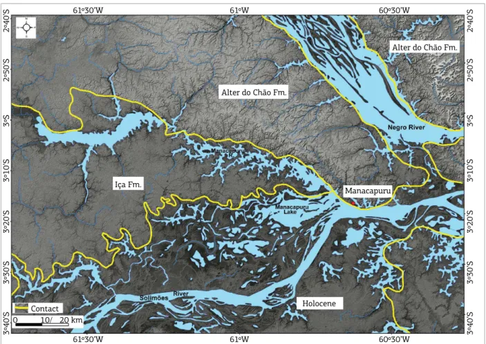
Zircon minerals collected from Alter do Chão Formation, locally known as Novo Remanso Formation, in the Manacapuru Municipality, not far westward from
Manaus (Fig. 6), provided U-Pb ages between 1,904 ± 7
and 1,910 ± 7 Ma originated from the Geochronologic Ventuari-Tapajós Province, and younger minerals indicated ages between 1,465 ± 51 and 1,346 ± 49 Ma (Mapes et al. 2006). he latter mineral ones, characteristic of Rondonian-San Ignacio Province, may have been carried by the Tapajós and Madeira rivers that cut through that province in the central portion of Brazil and flowed into the ancestral Amazon River, below Manaus, when this large river still lowed westwards.
Moreover, as was also to be expected, the direction of the ancestral Amazon River lowed westward until the early Late Miocene, and no Andean mineral or palynomorph was found in Alter do Chão or its equivalent Novo Remanso Formation. However, the lack of Andean-sourced palino-morphs and minerals in the Middle Miocene Alter do Chão Formation led to concluding incorrectly the Purus Arch would have functioned as a geographical barrier, preventing deposition of any material coming from the Andes, up to the Pliocene (Mapes 2006, Dino et al. 2012, Nogueira et al. 2013). In Solimões Basin, Repouso Formation sandstone zircons, from the well 31MT-0003-AM, located in the town of Tefé (Amazonas State), dated by Russel W. Mapes, indi-cated U-Pb Archean ages. Russel datings were presented in a table by Abinader (2008, p. 15) in his master’s dissertation.
his indicates the continuation of the luvial transport, in the Middle Miocene, of clastics from the Archean-aged Amazon Basin’s Central Amazonia Geochronological Province to the Solimões Basin.
Solimões Formation surface samples, still in the Township of Tefé, collected by Mapes (2009), present several popula-tions made up by ages younger than 1.5 Ga, being a promi-nent group with U-Pb ages close to 210 Ma, consistent with an Andean derivation. Samples still contain zircon minerals with ages of 550 Ma (Brasiliano), 1,110 Ma (Sunsás) and 1,400 Ma (Rondonian-San Ignácio). hose zircon mineral datings are similar to those pertaining to the ages of the zir-con minerals presently found in the sands of the Solimões River valley, in that same locality, obtained by Mapes (2009). In that region, Solimões Formation is capped by Içá Formation as old as Pleistocene and younger sediments.
Data presented by Figueiredo et al. (2009) relative to Sm-Nd dating of Foz do Amazonas Basin strata show that the Early Miocene and Early Pliocene layers have model ages, typical to Maroni-Itacaiunas Province (1.95 to 2.2 Ga), corresponding to the coastal lands of the State of Amapá which are joined with the Foz do Amazonas Basin. Middle-Miocene samples from Foz do Amazonas Basin pro-vide Sm-Nd model ages that correlate with the ages (1.8 – 1.55 Ga) of the Rio Negro-Juruena Province, a region close to the western boundaries of Brazil.
It is interesting to note that ages of zircon minerals from Central Amazonia and Ventuari-Tapajós provinces, which now occupy over 50% of the area traversed by the Amazon River, were not found in the earliest Late Miocene sediments of Foz do Amazonas Basin. Latrubesse et al. (2010) raised this inquiry to the model presented by Figueiredo et al. (2009). On the other hand, the rather abundant presence of zircon minerals dated as Brasiliano in the earliest Late Miocene sed-iments of Foz do Amazonas Basin (personal communication from Jorge de Jesus Picanço de Figueiredo 2015) indicates a source diferent from the one of the cratonic areas crossed by the Amazon River, keeping in mind that the ancestral Amazon River drainage lowed westward up to the earliest Late Miocene. herefore, a more plausible source for these earliest Late Miocene and older sediments would be the Grajaú Basin (Parnaíba Basin) and the Tocantins River and surrounding areas (Fig. 4), through the Marajó Basin, as can be inferred from the work of Nascimento (2006).
providing the formation of lakes and swamplands in the region. During the sea-level lowering in the Tortonian, the Colombian Vaupés Arch also prevented the headward erosion of the rivers southward from that structural feature.
he Amazon River loodplain has an average breadth of 40 km in the axis of the basin with a very low elevation. Nowadays, in Santarém municipality, the Amazon River, about 850 km from its mouth, reached the quota of min-imum water depth of 5.5 m above sea level in the 1997 low-water season, and the Alter do Chão Formation top of the hill of its type-section (Serra Piroca and well 1-AC-1-PA, Pará) reached about 130 m (Caputo 2011a,b). Altitude of other plateaus reaches higher elevations in other nearby areas.
In Manaus, nearly 1,400 km from the sea, the mini-mum Amazon River level reached 13.63 m in the low water period in 2010, according to Manaus Harbor Data (2014). his value represents a lower than 1 cm/km gradient and the elevation of the Alter do Chão Formation top reaches, in average, over 100 m in the vicinity.
In the town of Tabatinga, sited on the triple border between Brazil, Colombia and Peru, and 3,128 km away from the sea, the level of the Solimões River reaches about 60 m, with a gradient close to 3 cm/km in the stretch to Manaus, and the mean altitude of the nearby hills is of about 80 and 100 m. In the current high sea-level condi-tions, sediments from the Andes still get to the sea, mainly those being held in suspension. According to Mapes (2009), 80% of the zircon minerals collected at the Amazon River mouth originates from the Andes, 5% from cratonic areas and 15% from lowland sedimentary rocks.
Acre Basin holds a higher relief than Solimões and Amazon basins and an increasingly thickening Cenozoic sedimentary pile towards the Andes, from where it received a large contribution of its sediments, since the Andes uplift-ing up to now.
he Negro River bottom, near its conluence with the Amazon river, has lately been measured to reach 103 m deep, at a narrow canyon-shaped proile; and, in many other places, it and its tributaries show to be around 80 – 90 m deep (Sioli 1967). hese depths could be the efect of neotectonics, current erosion on account of local hydrody-namics in the rivers, or due to the sea-level lowering in the Pleistocene. he latter assumption may be admitted, since the Pleistocene lasted from about 2,588,000 to 11,700 years ago (International Commission on Stratigraphy), when sea level began to rise. he last sea level rise reduced erosion rate leading to sedimentation along the valleys, loodplains and banks of the Amazon River and its tributaries, but the current bottom load on this river consists of sand (ine and coarse) associated with the load in suspension (Sioli 1967). Many of the Amazon River tributaries are drowned, with
their valleys disproportionately large in relation to the river’s current discharge. hose rivers are being called “rivers-lakes” (Sioli 1967), yet technically they are interior rias or luvial rias. Many of these rivers do conluence with the Amazon River and other major rivers, and are in illing process, where sedimentation at their mouths consists of muddy materi-als (clay and silt), like at the mouths of the Tapajós, Negro, Coari, Tefé rivers and others. Some rias occur away from the current large river loodplains and develop on the bound-aries of the oldest luvial terraces, during the migration of the channels (Soares 2007). Lake Manacapuru is an inner ria whose damming by the Amazon River sedimentation is causing its illing, mainly in the boundary of the Amazon River loodplain (Fig. 6). his morphology can not have been elaborated by those rivers current draining conditions, with their almost stagnant waters and broad valleys. his river drowning may be attributed to the sea level rising in the Holocene (Sioli 1967).
With the subsidence of the Gurupá Arch in the Tortonian, the Amazon River headward erosion and captures opened a pathway from Marajó Basin to the basins in the west of South America up to the Andes. It is deduced that, at this time, a rather deep incision of the Amazon River drain-age occurred, as a consequence of the steep sea level drop. he deep incision on the valleys impeded deposition on loodplains, lakes, point bars and luvial deltas, which no longer existed. At that time, swamps started to be drained and destroyed, and the steep river valley slopes were broadened by erosion due to the less resistance to erosion of the beds of Alter do Chão and Repouso formations. his must have brought about environmental changes and the extinction of many terrestrial and aquatic species living in those habitats. herefore, during the early Late Miocene (Tortonian), the supericial regolith was transported through the deep val-leys to the sea in the east, with no deposition and erosion occurring in the entire continent.
With the deglaciation and consequent sea-level ris-ing, at the end of the Late Miocene (Messinian) and early Pliocene, the valleys, before under an erosion regime, came at some point to be illed, that is, the Solimões Formation sedimentation started to prevail where there was room for its accommodation and then spread over part of the Repouso Formation top plains.