1Instituto de Geociências, Universidade Estadual de Campinas – UNICAMP, Campinas (SP), Brazil. E-mail: [email protected]
2Programa de Pós-Graduação em Geociências e Meio Ambiente, Universidade Estadual Paulista Júlio de Mesquita Filho – UNESP, Rio Claro (SP), Brazil.
E-mail: [email protected] *Corresponding author.
Manuscript ID: 20160021. Received in: 01/28/2016. Approved in: 05/14/2016. ABSTRACT: Southwestern São Francisco Craton makes limit with Brasília thrust-fold belt and involves rocks from Archean to formed during the Brasiliano-Pan Africano Neoproterozoic event, including a maic-ultramaic belt (Morro do Ferro Greenstone Belt) hosted along the Archean counterpart. his greenstone belt hosts two-nickel deposits (Morro do Níquel and O’Toole, respectively silicate and sulide types) and occurrences. his study applies an empirical-conceptual model for lateritic nickel deposits formation into geographic information systems with aerogeophysical data (magnetic and gamma-spectrometry) and digital elevation models (terrain relief and slope). Our contribution aims for nickel deposits favorability mapping using a simple mathe-matical operator over a supporting spatial database translating the con-ceptual exploration model into evidential layers for geological processes involved on deposit formation. Evidential layers constructed for identi-ication of elements pertaining the supergene nickel mineral system are given by analytic signal amplitude maps, thorium over potassium ra-tio images, and digital elevara-tion models and slope maps, derived from shuttle radar topography mission digital elevation models. Evidential layers integration through binary layers algebraic sum identiied efec-tively known deposits and occurrences with its outputs highlighting possibilities for unknown resources in this under-explored terrain. KEYWORDS: prospection; mineral exploration; geographic infor-mation systems.
RESUMO: A região sudeste do estado de Minas Gerais encontra-se no limite do Cráton do São Francisco com um sistema de dobras, empurrão e cisalhamento formados no Neoproterozóico no evento Brasiliano-Pan Africano, com envolvimento de assembleias do arque-ano até essa idade e inclui associação de rochas máicas- ultramáicas (Greenstone Belt Morro do Ferro). A esta unidade arqueana estão associados depósitos minerais de níquel (Morro do Níquel e O’To-ole, supérgeno silicatado e sulfetado, respectivamente) e ocorrências minerais. Neste estudo se propõe a aplicação de um modelo concei-tual empírico de formação de depósitos de níquel laterítico para implementar técnicas de geoprocessamento sobre dados aerogeofísicos (magnéticos e gama-espectrométricos), modelos digitais de elevação (topograia e declividade de terreno) e geologia para a identiicação de áreas prospectivas no Greenstone Belt Morro do Ferro. A interpre-tação e o processamento desses dados permitiram a produção de planos de informação que registrassem processos geológicos necessários para a formação desses depósitos. A integração deles por um modelo de soma algébrica de camadas binárias possibilitou o mapeamento de zonas de potencial mineralização em níquel de forma eicaz, identiicando mineralizações conhecidas e até mesmo delineando novos tratos de possível mineralização em um terreno ainda pouco explorado. PALAVRAS-CHAVE: prospecção; exploração mineral; sistemas de informação geográica.
A mineral potential mapping approach for
supergene nickel deposits in southwestern
São Francisco Craton, Brazil
Uma abordagem de mapeamento de potencial mineral dos depósitos de
níquel supérgeno do sudeste do Cráton do São Francisco
INTRODUCTION
Archean greenstone belts host important nickel reserves along ultramaic/maic plutonic and volcanic systems, includ-ing its subsequent deformation products, through metamor-phic/hydrothermal alteration redistribution, and frequently its weathering products (Golightly 1979, Marsh et al. 2013, Butt & Cluzel 2013). Despite contribution from sulide deposits in nowadays economics, the lateritic resources play an important role on nickel reserves with tenors vary-ing from a 1.0% average with abnormal higher grades up to 3% Ni (Marsh et al. 2013, Butt & Cluzel 2013). South America complies with 8% of the world nickel resources with lateritic counterparts accounting for the most of it, in contrary to the common major input from sulide ores (Peck & Huminick 2016).
he São Francisco Craton presents a complex tecto-no-stratigraphic association of trondjhemite-tonalitic-gra-nodioritic gneisses and volcano-sedimentary belts including an Archean metavolcano sedimentary sequence along its lim-its with Tocantins Structural Province (Teixeira & Danni 1979, Hasui 2010). his metavolcanic sequence, named Morro do Ferro Greenstone Belt (MFGB), hosts two nickel deposits along its maic-ultramaic members, as follows: a silicate- supergene mine (Morro do Níquel MNi mine), and a poly-metallic komatiite-hosted Ni-Cu-Co PGE sul-ide deposit (O’Toole, Brenner et al. 1990). he greenstone belt sequence received considerable exploration interest up to 1990s, including exploration for precious metals, with little activities since then, and extensive prospective belts being undeveloped (Brenner et al. 1990, Feola 2004). Recent geologic remote sensing and geomorphological observations by Faria Jr. (2015) pointed out towards unexplored nickel endowment along the MFGB, despite that the terrain passed through diverse exploration cycles. Given its potential and areal extension, the greenstone belt is suitable for regional remote sensing applications and integration on public data-bases towards vectoring potential areas.
Mineral potential mapping applications encompasses probabilistic methods for spatial distribution modelling through data- or knowledge-driven approaches; the later relying on expert information based modelling of the tar-geted phenomena (Carranza 2011). Both approaches are useful depending on data base availability, prior knowledge and expert conceptual background (Bonham-Carter 1994). Prospectivity analysis for nickel systems are common for sul-ide-bearing mineralization, from magmatic to hydrother-mal ones (Porwal et al. 2010, Markwitz et al. 2010, Lisitsin et al. 2013, Andrade et al. 2014) with little focus on super-gene systems, which counts only in Carranza et al. (1999) work, that followed Golightly (1979) conceptual model for
ore formation. In this study, we apply a knowledge-driven system with a simple mathematical operator, introducing geophysical evidential layers in a restricted database con-text, following a conceptual supergene nickel-ore formation given by aspects on the classical model by Golightly (1981) and further improvements (Brand et al. 1998, Marsh & Anderson 2011, Marsh et al. 2013).
As the MFGB endures a long time under-exploration, we present here an update on its potential, highlighting the need of more research on its evolution and metallogenesis, and the shortage on public exploration data. herefore, look-ing forward the understandlook-ing of mineral deposits distribu-tion in MFGB and improving its exploradistribu-tion attractiveness, we conducted an application of geoprocessing techniques on geophysical data and digital elevation models to assess mineral potential for supergene nickel deposits. Moreover, it still does not count on a regional mineral potential map-ping evaluation for nickel (or whatever minerals).
GEOLOGY BACKGROUND
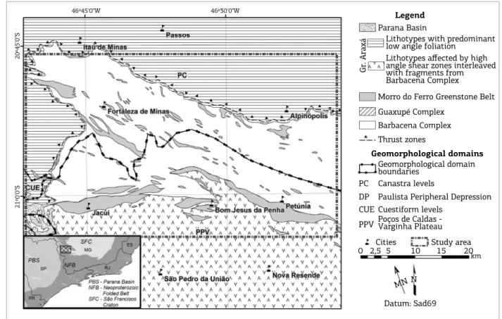
he Neoproterozoic Araxá Group consists in a metasedimen-tary sequence thrusted up over the craton, given by psamopelites, pelites, graywackes and calc-silicate rocks with minor volcanic and volcaniclastic terms (Zanardo et al. 1990, Simões 1995). his assemblage outcrops in an East-West trending structure with a late tectonic low-angle shearing foliation (Passos Nappe, Simões 1995) that grades into a high-angle fabric further south.
Discussion over MFGB genesis and evolution is not recent and points out towards two hypotheses: that this association presents (truly) a greenstone belt association or at least a part of a dismem-bered one, or it represents an ophiolite complex (Teixeira & Danni 1979, Brenner et al. 1990, Carvalho et al. 1993, Szabó 1996, Zanardo et al. 2006, Lima 2014). Faria Jr. (2011) argues that Morro do Níquel ultramaics, previously considered part of the MFGB, have no similarities to greenstone belt associations and lacks deinite identiication of its origin. Widespread magnetite presence is described in those lithotypes (Brenner et al. 1990, Zanardo 1992, Carvalho et al. 1993, Szabó 1996, Feola 2004), including its preservation on weathered proiles (Oliveira et al. 1998), thus aiding these rocks identiication on magnetic data. As for gamma-spectrometric surveys, Potassium (K) is related in concentrations up to 1% (Feola 2004, Lima 2014) including expressive K leaching on weathering proiles (Oliveira et al. 1998),
and horium (h) is reported as lower than 3 ppm in equivalent concentration (Lima 2014).
Elevation in the area ranges from 703 to 1,346 m above sea level, and a diferential relief dissection is present. Elongated convex-concave hills and mountains in homogeneously eroded patterns with inter-luvial lats dominate the geomorphology, whereas other portions present highly developed dissection with higher erosion rates exposing less-weathered bedrock (RADAMBRASIL 1983). his heterogeneous relief dissec-tion represents a multi-event erosion history, presenting high-ly-evolved ferruginous concretions along lat-topped regional highs developed in a Post-Cretaceous evolution with strong structural and lithology control, and advanced erosion surface on higher order streams (Oliveira 1990, Oliveira et al. 1992).
THE CONCEPTUAL FRAMEWORK
FOR LATERITIC NICKEL DEPOSITS
FORMATION
Supergene concentrations play an important role on nickel market, corresponding to 60% of world’s supply (Butt & Cluzel 2013), also as important contributors to
Figure 1. Subject area outline with geological and geomorphological framework, and regional tectonic and
political setting (inset, lower let). Geology is adapted from Zanardo (2003), and geomorphology elements from RADAMBRASIL (1983).
Legend
Parana Basin
Gr. Araxá
Lithotypes with predominant low angle foliation
Lithotypes affected by high angle shear zones interleaved with fragments from Barbacena Complex
Morro do Ferro Greenstone Belt Guaxupé Complex
Barbacena Complex Thrust zones
Geomorphological domains
Geomorphological domain boundaries
PC DP CUE PPV
Canastra levels
Paulista Peripheral Depression Cuestiform levels
Poços de Caldas -Varginha Plateau
Study area 2,5
0 5 10 15 20
km
Datum: Sad69
MNN
Cities
46º45'0"W 46º30'0"W
20º45'0"S
the cobalt, platinum group elements and copper global budget, deriving mainly from activities in New Caledonia, Australia, Indonesia and Cuba (Marsh et al. 2013). Deposits shares similarities from parent rock to the weathering proile, despite remarkable diferences on climatic conditions limits its formations up to 20º from the Equator and occurring over diversely originated maic/ultramaic bedrock (Marsh et al. 2013, Butt & Cluzel 2013).
Despite mineralogical and classification differences between maic-ultramaic rocks, from plutonic to extrusive counterparts, these rocks are (overall) suitable for supergene nickel enrichment, and to other geochemically similar met-als, with serpentinites being the most common parent rock (Golightly 1981, Oliveira et al. 1992, Brand et al. 1998, Marsh & Anderson 2011). Parent rock composition rep-resents primary control on ore formation, as the rock under weathering must have minerals capable of releasing nickel from its structure and capturing it from subsurface luids (Brand et al. 1998), like olivine, pyroxenes and amphiboles (Lelong et al. 1976). Highly suitable lithotypes are, as fol-lows: dunites, peridotites, harzburgites and wehrlites on ophiolite sequences from both Alpine and obducted types on large-scale folding belts; olivine-rich komatiites (like the ones in MFGB); and banded maic-ultramaic intrusions on Pre-Cambrian basement (Brand et al. 1998).
An important stage on supergene nickel concentration is lateritic proile onset over these lithotypes and its preserva-tion from erosion. Mineralizapreserva-tion is given by a highly-vari-able association of Fe-(Mn, Ni, Co) oxides, Ni-Mg-(Co) hydrous silicates, amorphous silica, serpentine, smectites and other clay mineralogy, also (Fe, Mg, Ca, Mn) carbon-ates and goethite, depending mainly on parent rock mineral-ogy, climate settings and its temporal evolution (Brand et al. 1998, Marsh & Anderson 2011). hose lateritic concen-trations are mainly associated with table-like landforms, remainders of previous palaeo-weathering surfaces topped by concretionary latosols with an armoring efect prevent-ing proile erosion and element dispersal (Meli et al. 1980, Oliveira et al. 1992).
he weathering process comprises geochemical and geo-morphological landscapes with a long-term evolution that controls the ions mobilization along the proile, its depo-sition on the proper sites and preservation along the time, with most concentrations being formed on Phanerozoic Eon over Archean to younger bedrock (Marsh & Anderson 2011, Butt & Cluzel 2013). Butt and Cluzel (2013) group Ni-laterite deposits in four types, as follows: lateritic regolith, hydrous Mg-silicate deposits, clay silicate type, and oxide deposits. his classiication varies from the most widespread Ni enrichment in the proile, Ni-hosting mineralogy, devel-opment stage and climatic conditions.
Supergene nickel concentrations in Brazil were reviewed by Meli et al. (1980), Oliveira (1990) and Oliveira et al. (1992), highlighting the quite conformable ore-forming environments and distribution along tropical climate. Taufen and Marchetto (1989) describes Ni, Cu, Co and Platinum Group Elements enrichment over primary sul-ide ore in O’Toole deposit with strong leaching of the sulides and host rock, secondary sulide crystallization and Ni depletion from the uppermost levels to the sap-rolite and bedrock leading to gossan formation similar to the proiles on the western Australian nickel ields. Faria Jr. (2011, 2015) pointed out towards important structural control on development of Ni-bearing supergene ores in Morro do Níquel and two other places along the MFGB – in Bom Jesus da Penha (BJP), along expressive ultramaic rock lenses, and in Jacuí, formed over less representative bodies of serpentinite bedrock.
his conceptual framework serves for developing a knowl-edge-driven approach for lateritic nickel deposits exploration along the MFGB, based on spatial features identiication on the digital dataset evidential layers/maps that relates to the necessary processes for ore formation.
SPATIAL DATABASE AND METHODS
Following the proposed conceptual model for depos-its formation and the geology background to the study area, a geoprocessing assessment of remote sensing data-base has proceeded to map mineral system elements on a database given by:
■ aerogeophysical information given by gamma-spectro-metric and magnetics data: survey 7 (Patos de Minas– Araxá–Divinópolis, 2006) from Secretary of Economic Development of the State of Minas Gerais (CODEMIG – Companhia de Desenvolvimento Econômico de Minas Gerais) with 100 m light clearance, 400 m survey line spacing on North-South direction, stored in digital media; ■ topography data from Shuttle Radar Topography Mission
(SRTM) 1 Arc-Second model (30 m spatial resolution); ■ regional geological maps from Zanardo (2003) and geo-morphology maps from RADAMBRASIL (1983), both digitized from hard media.
Table 1 brings an outline on data processing, evidential map properties and geoprocessing outputs.
Analytic signal amplitude (ASA) (Roest et al. 1992) was applied on magnetic data to enhance high magnetization areas, considered here as evidence for maic-ultramaic bed-rock according to its common high content on ferromagnetic minerals and common magnetic response (Grant 1985a, 1985b). ASA also enhances areas away from our interest, like non-maic ultramaic (highly) magnetic bodies, but it is capable of depicting high magnetization zones despite its dimensions, shape and depth (Roest et al. 1992, Nabighian et al. 2005). According to these premises and the description of widespread magnetic mineralogy on target lithology, we con-sider high magnetization zones as possible presence of maic ultramaic rocks, except expressed otherwise from evidences.
Gamma-spectrometric data processing aimed for map-ping weathering properties along the landscape through analysis of h and K distribution according to its diferent geochemical behaviors, targeting evolved soil horizons over maic-ultramaic bedrock (Wilford et al. 1997, Ulbrich et al. 2009, Ferreira et al. 2009, Marsh et al. 2013). Potassium has greater mobility than Thorium on weathering con-ditions, presenting higher depletion rates (Wilford et al. 1997, Ferreira et al. 2009, Ulbrich et al. 2009). horium has decreased mobility, preferring ixation on hydroxyl-bearing
minerals and colloids like newly-formed Fe-Mn oxide-hy-droxides in the soils (Dickson & Scott 1997, Ulbrich et al. 2009), only moving on highly acidic conditions (Langmuir & Herman 1980, Boyle 1982). Considering the geochem-ical behavior of these elements, a scenario of K depletion and h ixing on evolved soils along the outer horizons in lateritic soil proiles (Wilford et al. 1997, Dickson & Scott 1997, Ulbrich et al. 2009). horium over Potassium ratio images can depict this mutual relationship.
SRTM topography data complied with a digital eleva-tion model (DEM) surface and slope maps for comparison to geomorphology information from RADAMBRASIL (1983). Slope calculation is as the gradient of height with map production in ArcGIS by an internal routine on the Spatial Analyst toolbox. Elevation and slope are important in this case as they help describing the lateritic proile preserva-tion stage, also for informapreserva-tion regarding water table control (Brand et al. 1998). Lateritic nickel deposit by Meli et al. (1980), Oliveira (1990) and Oliveira et al. (1992) that higher elevation plains in southeastern Brazil preserves the oldest weathering proiles. Comparing SRTM-derived information to geomorphology and the conceptual supergene-nickel min-eralization model led to evidence maps buildup.
(I) Spatial database building
Assembling, selecting and integrity check in
input data
Digital elevation model (raster file)
Magnetic and gamma-spectrometric data (grid
file)
Bedrock geology (polygon)
(II) Data processing
Information extraction from
input data and binary evidence
map creation
(A) DEM surface interpolation
(A) Magnetic Field Anomaly, Thorium and Potassium
equivalent channels interpolation to surface
(A) Lithotypes spatial distribution
evaluation and projection check
(B) Slope and Elevation map calculation from DEM
(B) Magnetic data
analytical signal filtering (B) Reprojection and correction
(C) Analysis for interest
threshold detection (C) Th/K ratio map creation
(C) Mafic-ultramafic rocks selection
(D) Reclassification into separate binary maps for
elevation and slope
(D) Analysis for interest threshold selection
(D) Reclassification into binary map (E) Reclassification into
separate binary maps for analytical signal and
gamma-ray
Evidence maps
Areas with slope ≤ 8º Areas with ASA > 0.0251
nT/m Mafic-ultramafic areas Areas with height > 900 m Areas with Th/K ratio > 26
(III) Data integration
Evidence maps combination through algebraic sum operation. Comparison with bedrock geology evidence layer and validation criteria.
Output map Lateritic nickel prospectivity map
Table 1. Information on processing and evidence layers buildup.
Information on maic-ultramaic rock outcrop comes from Zanardo (2003) map and serves as comparison factor for prospectivity models presented on this paper.
Aerogeophysical data were processed using Geosoft Oasis Montaj 7.5 platform and ESRI ArcMap 10.2 for DEM data. he latter was also used as geographical information system for data integration, analysis and modelling. Evidence layers were resampled into a common 30 m cell size, on Universal Transversal Mercator projection systems in 23S Córrego Alegre Datum. his was necessary for common cartographic projection and cell size compatibility between evidence layers.
Conversion into binary raster
Data analysis and interpretation led to the establishment of four information layers, selected as input predictor maps for prospectivity modelling. hese information layers were subsequently converted into binary maps according to spe-ciic data ranges, according to criteria as follows.
A given value range in an information layer was selected as representative of interest elements for nickel prospecting. hen, a reclassiication of the raster was applied with the absence of the interest range leading to pixel assignment as zero, meanwhile the presence of the interest values leads to its assignment as one. Converting the evidence layers into a binary data space is necessary for subsequent layer inte-gration into a mineral deposit favorability map. Data range statistical analysis to each geophysical data layer allowed deinition of interest data ranges, as follows. Deining a lower limit in 0.0251 nT/m for ASA layer (third quartile, from 0.00 to 2.42 nT/m) gives highest magnetization values in the layer, meanwhile for the h/K ratio layer a value of 26.00, the median from a range between 2.85 and 45.31, is considered to separate values outstanding background. A cut-of height on 900 m for the digital elevation model and an upper limit in 8º for slope was deined representing the higher levels to be under efect of deep laterization and hosting tabular relief zones. Maic-ultramaic rock outline polygon deines the binary information, as areas inside the polygons give presence and outside them give absence.
Evidence layer integration into
prospectivity map
Following evidence layers deinition and preparation, its combination into a prospectivity (or favorability) map can take place by a mathematical operator. In this case, the selected operator is algebraic sum, a pixel per pixel oper-ator that sums up a pixel value of each information layer into an output layer – the prospectivity map. his opera-tion gives a range of occurrence probability of a deposit in a given pixel, from zero (absence of evidence in the whole layer dataset) to four (presence of evidence in every layer in
the dataset). Carranza et al. (1999) applied this integrative technique using diferent layers; despite its simpler structure, its outcomes have a straightforward interpretation and eas-ily applied in common GIS platforms through raster oper-ations with good-standing results.
his procedure is an intermediate level operator from the restrictive Boolean logic modelling that deines an output of data from zero (total information absence in considered layer space) to one (presence of any/or all evidence layers, depend-ing on operator selection) and a binary index overlay operator (Bonham-Carter 1994). he later depends on weight selec-tion for the evidence layers, presenting subjectivity issues. he algebraic sum presents subjectivity levels arising from evidence layer input, and these evidence layers selected data range. herefore, it returns a value scale in the inal model, allowing ranking these scores. Combinations for a four-fold evidential layer sum are represented in a Venn diagram (Fig. 2), showing up to 16 possibilities for output pixel scoring.
RESULTS AND DISCUSSION
Input evidence layers
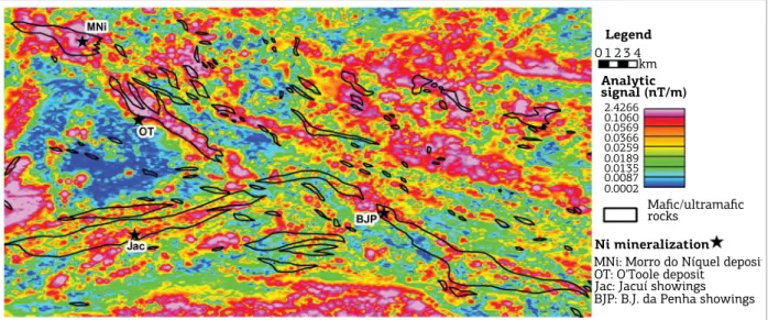
Analytic signal amplitude maps
ASA map highlights area’s structural grain with long, lin-ear, high- magnetization zones that relates to tectonic domains and speciic lithology (Fig. 3). Notably a linear to sinuous NW-SE trend that inlects eastwards to E-W directions and agrees to Campo do Meio shear belt structural fabrics along
Topography (>900 m)
Th/K ratio (>26)
Slope (≤8 degrees)
Analytic Signal Amplitude (>0.0251 nT/m)
Figure 2. Venn diagram representing score possibilities in four-fold evidential layers algebraic sum into the prospectivity model. Zero stands for absence of
shear zones (Morales 1993). Besides maic-ultramaic bod-ies, high magnetization regions could be related to banded iron formations, deep-seated basic dykes, Phanerozoic intru-sive basic rocks (mainly on study area west side) and high-ly-weathered regions with maghemite or ferruginous concre-tions along hill tops. Comparing maic-ultramaic bedrock distribution to ASA maps, it shows that the signal range taken for ASA map transformation into the binary evidence layer (Fig. 4) is compatible (e.g.: ultramaic body east of O’Toole deposit). he binary ASA map (Fig. 4) also shows that some maic-ultramaic bodies are not highly magnetic as expected (e.g.: ultramaic body hosting BJP occurrences), preventing complete identiication of the ultramaic bodies by means of magnetic data, and also highlights potential high magnetiza-tion trends conformable to MFGB direcmagnetiza-tion. ASA map usage
as evidence layer needs caution considering its performance on mapping target bodies. Target bedrock misidentiication or prevention can happen as the region presents polycyclic struc-tural and metamorphic evolution, encompassing retrograde metamorphism on late Brasiliano–Pan African tectonic event, including an uncertain-age serpentinization event, all related to possible magnetite destruction and construction (Carvalho et al. 1993, Zanardo 1992, Lima 2014, Faria Jr. 2011).
Gamma-spectrometric maps
horium-Potassium ratio maps (Fig. 5) poorly depict bed-rock geology, presenting small resemblance on maic-ultramaic rock outline along the O’Toole deposit vicinity; meanwhile, they present interesting values (greater than 26) on the South-Central region. heir distribution clearly relates to geomorphology,
Legend
km 0 1 2 3 4
Analytic signal (nT/m)
2.4266 0.1060 0.0569 0.0366 0.0259 0.0189 0.0135 0.0087 0.0002
Ni mineralization
Mafic/ultramafic rocks
MNi: Morro do Níquel deposit OT: O'Toole deposit
Jac: Jacuí showings BJP: B.J. da Penha showings
Figure 3. Analytic signal amplitude map, including known nickel mineralization and maic-ultramaic bedrock outline.
Legend
km 0 1 2 3 4
Ni mineralization
Mafic/ultramafic rocks
MNi: Morro do Níquel deposit OT: O'Toole deposit
Jac: Jacuí showings BJP: B.J. da Penha showings
Analytic signal in binary code
0) 0.0251 nT/m 1) 0.0254 nT/m
as expected, highlighting eroded sections, including low-slope to lat regions. A comparison to DEM (Fig. 6) shows that low h/K ratio values fairly coincide to the topography lower lev-els (< 900 m) and probable K ixation in weathering proile. he widely high ratio area in the southern part of the map coincides with an evolved geomorphologic surface in Varginha-Poços de Caldas Plateau upper levels (RADAMBRASIL 1983).
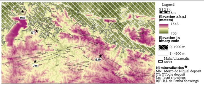
Digital elevation and slope models
Elevation ranges from 703 to 1346 meters above sea level with the greatest heights lying in southern part along NW-SE striking ranges (Fig. 6) that occurs from the center to the north, and a distinct NE-SW plateau on western side.
hose NW-SE striking ranges are associated to chemically resistant Neoproterozoic siliciclastic rocks supporting these ridges. Elevation and slope characteristics describe the land-forms, giving some insights into the diferent erosion levels. It is remarkable that the northern part of the study area hosts topographic levels lower than 900 meters, discarded in our binary evidence map (Fig. 6). To consider elevations higher or equal to 900 m as potential for mineralization in the area is in accordance to RADAMBRASIL (1983) description of those as being areas with minor erosion.
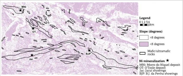
Slope ranges from zero to 68º with widespread distribu-tion of tabular/plan relief following the area’s structural pat-tern, including higher slope areas outlining regional plateaus
Legend
km 1 0 2 34
Ni mineralization
MNi: Morro do Níquel deposit OT: O'Toole deposit
Jac: Jacuí showings BJP: B.J. da Penha showings
Elevation a.b.s.l (meters)
1346
703
Elevation in binary code
0) <900 m
1) >900 m Mafic/ultramafic rocks
Figure 6. Digital elevation model showing areas considered in binary evidence layer, known nickel mineralization and maic-ultramaic bedrock geology.
Legend
km 1 0 2 34
Ni mineralization
MNi: Morro do Níquel deposit OT: O'Toole deposit
Jac: Jacuí showings BJP: B.J. da Penha showings
Thorium/Potassium ratio 45.31 27.93 19.80 14.79 11.12 8.58 6.50 4.87 2.85
Thorium/Potassium ratio in binary code
0) <26
1) >26
(Fig. 7). Furthermore, areas with slope less or equal to 8º display lower erosion rates (also evident in h/K ratio maps). Higher slope areas can also preserve an evolved weathering proile, but, according to Meli et al. (1980), the chance to observe them with its better preservation occurs in areas surrounding plan relief levels.
It is worth notice that mass-transfer processes along geomorphology and water table are conformable to lithol-ogy and structural patterns. This way, both DEM and slope binary evidential layers mark possible transport trends. DEM and slope maps can be compared to Th/K ratio maps for information on erosion and deposition regional tracts. Despite that main topography outline is in accordance to geological features, it is not possible
to establish an immediate relationship between slope and topography maps, and mafic-ultramafic bedrock.
Mineral potential maps and discussion
On the mineral potential map output, each pixel is the sum of the input evidential layers dataset for that pixel, and it is not possible to unveil which input layers contribute to that score, presenting a qualitative value ranging from zero to n, as n stands for the number of input evidential layers.
A irst model that takes into consideration the four evidential layers (ASA, h/K ratio, elevation and slope) for the whole study area permits inference on possibilities for supergene nickel deposits exploration in a regional context (Fig. 8).
Legend
km 1 0 2 34
Ni mineralization
MNi: Morro do Níquel deposit OT: O'Toole deposit
Jac: Jacuí showings BJP: B.J. da Penha showings
Mafic/ultramafic rocks
Slope (degrees)
>8 degrees
<8 degrees
Figure 7. Slope map in binary format for study area, including known nickel mineralization and maic-ultramaic
bedrock outline.
Legend
km 1 0 2 34
Ni mineralization
MNi: Morro do Níquel deposit OT: O'Toole deposit Jac: Jacuí showings BJP: B.J. da Penha showings
Mineral potential map for lateritic nickel concentrations -total area
0) No potential 1) Poor 2) Low 3) Intermediate 4) High
Considering the number of input evidential layers (4) for this model, a score 4 in a pixel is the sum of present evidence in all evidential layers, being the one with higher potential to host a supergene nickel deposit. In contrast, a pixel with score zero is the one in which any of the evidential layers are marked as prospective. Middle-class scores (1 to 3) got the chance to be the combination of any of them, as shows the Venn diagram (Fig. 2), and it is not possible to con-irm which layer contributed to that score. It is veriiable from Figure 8 that the prospectivity model delineates sev-eral trends according to the structural pattern, as expected given previous examination of evidential layers (ASA, slope and DEM, mainly).
Statistics from this model show that, from a 2000 km² area, about 10% of them are assigned scoring 4, besides 40% scored as poor- to low-potential (scores 1–2). his presents an interesting rate since the screening of these areas presents possible economy on exploration budgets.
A series of high potential areas is highlighted in the southern portion of the area, far south of Jacuí and Bom Jesus da Penha occurrences (Fig. 8), identiied as products of higher weathering rates associated higher topography over granulite facies metamorphic rocks with higher magne-tite content and h/K ratios (Campos Neto & Caby 2000, Zanardo et al. 2006).
As the area presents considerable geological cartog-raphy, a comparison from our irst model and known prospective bedrock has been produced (Fig. 9), show-ing up interestshow-ing features as follows. he discontinuous prospective belt is not highly favorable as a whole, with higher potential scores clustering, as expected, as lateri-zation process is a complex process interplay. Inclusion
of the ASA evidential layer in this model enhances struc-tural discontinuities, also accounting for introduction of information on magnetic banded iron formations pres-ence as levels amid the maic-ultramaic rocks, as observed in the MFGB and O’Toole deposit (Brenner et al. 1990, Carvalho et al. 1993).
It is noticeable that intermediate to higher potential scores map the Morro do Níquel and O’Toole deposits, and Bom Jesus da Penha occurrence, as expected from known mineralization. Despite different mineralization style on O’Toole, it is evident that this processing rou-tine is able to map mafic-ultramafic rocks at least to some point. The Morro do Níquel deposit is mapped as a high potential area for supergene nickel concentrations in agreement to its weathering profile developed over ultramafic bedrock (serpentinite, overall 0.3% nickel grade) with ore grading up to 4% nickel and averaging 1.5 to 2.0%, representing a concentration factor up to 700% from the parent rock (Faria Jr. 2011). At Bom Jesus da Penha area, Faria Jr. (2015) highlights existence of an enrichment factor up to 350% on mottled sapro-lite formed over chlorite-amphibole schist (1198 ppm Ni), also concentrating cobalt and copper. Besides, this author describes a weathering profile along Jacuí, formed on propitious geomorphologic conditions over possible ultramafic bedrock. In the absence of public regional exploration geochemistry data (stream sediment or whole rock chemistry), we agree that the proper definition of known mineralization along our models serves some-what as validation.
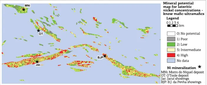
In the light of different possibilities for scoring in the previous prospectivity model, a second model is
Figure 9. Mineral potential map for supergene nickel deposits in the known maic-ultramaic bedrock for the
ASA-included model.
Legend
km 1 0 2 3 4
Ni mineralization
MNi: Morro do Níquel deposit OT: O'Toole deposit
Jac: Jacuí showings BJP: B.J. da Penha showings
Mineral potential map for lateritic nickel concentrations -know mafic-ultramafics
presented (Fig. 10), accounting only the Th/K ratio, DEM and slope evidential layers over known prospec-tive bedrock areas (35% of the total area) as it presents an important prospectivity control by itself. A consid-erable change is observed in a comparison from Figure 8 to Figure 9, showing up more continuous higher pro-spectivity areas, especially in the southern mafic-ultra-mafic bodies. Known mineralization appears as inter-mediate to high scores, and BJP defines a big potential areas cluster. Higher potential spots exist on south-cen-tral region of the study area, also in an isolated NW-SE small lens-like body in the central-north region.
Statistics from prospectivity scores in the ASA-including model show that 20% of the area scores a high potential level; meanwhile, in the model accounting only for areas with maic-ultramaic bedrock the areas ranking 4 rep-resents 33% of the total. hat said it is feasible that ASA possibly acts as restrictive evidence in the modeling and its exclusion can be considered for a regional scale appraisal for known bedrock. herefore, it is necessary to supply other evidential layer type to prevent non-target rock inclusion or its misidentiication (e.g.: gravity data, optical remote sensing information).
CONCLUSION
This contribution presents a straightforward pro-cedure to convert a conceptual mineral deposit model into an exploration model through simple geoprocess-ing techniques that help screengeoprocess-ing and rankgeoprocess-ing poten-tial areas in regional exploration programs. Concerning
restricted data availability and its wide-scale nature, which includes relatively poor data resolution in geo-physical data and absence of regional geochemistry data, this application proved itself able to identify regional prospective tracts for supergene nickel deposits in the MFGB. Evidential layers mapping effectiveness is sub-ject to a range of issues like spatial and spectral reso-lution, survey orientation, data spatial projection and bedrock geological aspects, thus, data set reliability and its proper handling plays an important role. Different evidential layers combinations are possible. Thus, its modifications are subjective in respect of expert deci-sion, like any knowledge-driven approach, as selection of both evidence layers and data range considerations are under its responsibility prior to mathematical inte-gration, as shows the previous example of change into the sum of evidential layers.
Evidence layer integration by algebraic sum on an equal weight basis is a simple and straightforward operator, rec-ommended to relatively simple exploratory models, and this practice also showed its capability in dealing with a restrict spatial database. herefore, we recommend caution, the use of a well-established conceptual model and ield check for feedback, as both overestimation and underestimation play a role.
In more advanced exploration, scenarios counting on more data types (e.g.: stream sediment geochemistry, grav-ity surveys, mineralogy spectra data) and knowledge over mineralization styles and geological processes, diferent sorts of evidential layers can be considered, including application of diferent mathematical operators for integration, possi-bly reducing subjectivity and improving success rate. Prior
Legend
km 1 0 2 3 4
Ni mineralization
MNi: Morro do Níquel deposit OT: O'Toole deposit Jac: Jacuí showings BJP: B.J. da Penha showings
Model with Th/K ratio, DEM and slope
evidence maps for know mafic-ultramafics
1) Poor 2) Low 3) Intermediate 4) High No data
Almeida F.F., Hasui Y., Brito Neves B.B., Fuck R.A. 1981. Brazilian structural provinces: an introduction. Earth-Science Reviews,
17:1-19.
Andrade L.B., Silva A.M., Souza Filho C.R. 2014. Nickel prospective modelling using fuzzy logic on Nova Brasilândia metasedimentary belt, Rondônia, Brazil. Revista Brasileira de Geofísica, 32(3):419-431.
Bonham-Carter G.F. 1994. Geographic Information Systems for Geoscientists: Modelling with GIS. Ontario, Pergamon Press, 398 p.
Boyle R.W. 1982. Geochemical prospecting for Thorium and Uranium deposits. Developments in Economic Geology, 16. Amsterdam,
Elsevier, 498 p.
Brand N.W., Butt C.R., Elias M. 1998. Nickel laterites: classiication and
features. Journal of Australian Geology & Geophysics, 17(4):81-88. Brenner T.L., Teixeira N.A., Oliveira J.A.L., Franke N.D., Thompson J.F.H. 1990. The O’Toole nickel deposit, Morro do Ferro Greenstone Belt, Brazil. Economic Geology, 85:904-920.
Butt C.R.M. & Cluzel D. 2013. Nickel laterite ore deposits: weathered serpentinites. Elements, 9:123-128.
Campos Neto M.C. & Caby R. 2000. Terrane accretion and upward extrusion of high-pressure granulites in the Neoproterozoic nappes of southeast Brazil: petrologic and structural constraints. Tectonics,
19(4):669-687.
Carranza E.J.M. 2011. Geocomputation of mineral exploration targets. Computers & Geosciences, 37:1907-1916.
Carranza E.J.M., Mangaoang J.C., Hale M. 1999. Application of mineral exploration models and GIS to generate mineral potential maps as input for optimum land-use planning in the Philippines.
Natural Resources Research, 8(2):165-173.
Carvalho S.G., Soares P.C., Antônio M.C., Zanardo A., Oliveira M.A.F. 1993. Geologia da sequência vulcano-sedimentar de Alpinópolis (MG). Revista Brasileira de Geociências, 23(1):38-51.
Dickson B.L. & Scott K.M. 1997. Interpretation of aerial gamma-ray surveys – adding the geochemical factors. Journal of Australian Geology & Geophysics, 17(2):187-200.
Faria Jr. I.F. 2011. Modelo estrutural da mineralização na jazida Morro do Níquel, Pratápolis, MG. Graduate Thesis, Instituto de Geociências e Ciências Exatas, Universidade Estadual Paulista “Júlio de Mesquita Filho”, Rio Claro, São Paulo, Brazil, 80 p.
REFERENCES
Faria Jr. I.F. 2015. Prospecção mineral de alvos potenciais à ocorrência de enriquecimento supergênico de níquel no Greenstone Belt do Morro do Ferro. MS Dissertation, Instituto de Geociências e Ciências Exatas, Universidade Estadual Paulista “Júlio de Mesquita Filho”, Rio Claro, São Paulo, Brazil, 137 p.
Feola J.L. 2004. Mineralizações auríferas hospedadas na faixa vulcano-sedimentar Jacuí-Bom Jesus da Pena – sudoeste de Minas Gerais. PhD Thesis, Instituto de Geociências e Ciências Exatas, Universidade Estadual Paulista Júlio de Mesquita Filho, Rio Claro, São Paulo, Brazil, 211 p.
Ferreira F.J.F., Fruchting A., Guimarães G.B., Alves L.S., Martin V.M.O., Ulbrich H.H.G.J. 2009. Levantamentos gamaespectrométricos em granitos diferenciados. II: o exemplo do Granito Joaquim Murtinho, Complexo Granítico de Cunhaporanga, Paraná. Revistado Instituto de Geociências – USP, 9(1):55-72.
Golightly J.P. 1979. Nickeliferous laterites: a general description.
In: Evans D.J.I., Shoemaker R.S., Veltman H. (Eds.). International Laterite Symposium. New York, Society of Mining Engineers, American Institute of Mining, Metallurgical and Petroleum Engineers, p. 3-23.
Golightly J.P. 1981. Nickeliferous laterite deposits. Economic Geology, 75th anniversary volume, 710-735.
Grant F.S. 1985a. Aeromagnetics, geology and ore environments, I. Magnetite in igneous, sedimentar and metamorphic rocks: an overview. Geoexploration, 23:303-333.
Grant F.S. 1985b. Aeromagnetics, geology and ore environments, II. Magnetite and ore environments. Geoexploration, 23:335-362.
Hasui Y. 2010. A grande colisão Pré-Cambriana do sudeste brasileiro e a estruturação regional. Geociências, 29(2):141-169.
Horsfall K.R. 1997. Airborne magnetic and gamma-ray data acquisition. Journal of Australian Geology & Geophysics,
17(2):23-30.
Langmuir D. & Herman J.S. 1980. The mobility of thorium in natural waters at low temperatures. Geochimica et Cosmochimica Acta,
44:1753-1766.
Lelong F., Tardy Y., Grandin G., Trescases J.J., Boulange B. 1976. Pedogenesis, chemical weathering and processes of formation of some supergene ore deposits. In: Wolf R.H. (Ed.). Handbook of stratabound and stratiform ore deposits, Elsevier, 3, p. 92-173. knowledge on regional scale tectonic settings and mineral
deposit styles permitted to compare the efectiveness of modelling process proposed here in respect to identiication of both maic-ultramaic host rocks and mineralized spots.
Despite the irst target in this practice is to map possi-ble areas with supergene lateritic nickel deposits, it also can track some elements with similar geochemical behavior, like copper and cobalt, including its fresh host rocks (Marsh & Anderson 2011). Nevertheless, availability of public geo-chemical exploration data would improve detection and validation for the two proposed prospectivity models, also helping on targeting for other elements than nickel.
ACKNOWLEDGEMENTS
Lima F.G. 2014. Evolução petrogenética das rochas máficas/ ultramáficas na área ao sul do Cráton do São Francisco, entre as cidades de Fortaleza de Minas e Jacuí-MG. MS Dissertation, Instituto de Geociências e Ciências Exatas, Universidade Estadual Paulista “Júlio de Mesquita Filho”, Rio Claro, São Paulo, Brazil, 104 p.
Lisitsin V.A., González-Álvares I., Porwal A. 2013. Regional prospectivity analysis for hydrothermal-remobilized nickel mineral systems in western Victoria, Australia. Ore Geology Reviews, 52:100-112. Markwitz V., Maier W.D., González-Álvares I., Mc Cuaig T.C., Porwal A.
2010. Magmatic nickel sulide mineralization in Zimbabwe: review
of deposits and development of exploration criteria for prospectivity analysis. Ore Geology Reviews, 38:139-155.
Marsh E.E. & Anderson E.D. 2011. Ni-Co laterite deposits: U.S.
Geological Survey Open-File Report 2011–1259. 9 p.
Marsh E.E., Anderson E.D., Gray F. 2013. Nickel-cobalt laterites: a deposit model. In: U. S. Department of the Interior, U. S. Geological Survey. Mineral deposit models for resource assessment: U. S. Geological Survey Scientiic Investigations Report 2010–
5070–H. Chapter H. 38 p. Disponível em: <http://pubs.usgs.gov/ sir/2010/5070/h/>. Acesso em: 15 de set. de 2015.
Meli A.J., Trescases J.J., Oliveira S.M.B. 1980. Les “laterites”
nickeliferes du Brésil. Cahier deOrstom, Série Géologie, 11:15-42. Morales N. 1993. Evolução tectônica do Cinturão de Cisalhamento Campo do Meio na sua porção ocidental. PhD Thesis, Instituto de Geociências e Ciências Exatas, Universidade Estadual Paulista “Júlio de Mesquita Filho”, Rio Claro, São Paulo, Brazil, 256 p.
Morales N., Carvalho S.G., Choudhuri A., Fiori A.P., Oliveira M.A.F., Rodrigues M.F.B., Soares P.C., Zanardo A. 1983. Geologia das folhas de Fortaleza de Minas, Alpinópolis, Jacuí, Nova Resende, MG. In: Simpósio de Geologia de Minas Gerais, 2, Belo Horizonte. Anais..., Belo Horizonte: SBG-MG, v. 3, p. 411-422.
Nabighian M.N., Grauch V.J.S., Hansen R.O., La Fehr T.R., Li Y., Peirce J.W., Philips J.D., Ruder M.E. 2005. The historical development of the magnetic method in exploration. Geophysics, 70(6):33ND-61ND. Oliveira S.M.B. 1990. Estágio atual do conhecimento acerca do minério laterítico de níquel no Brasil e no mundo. Revista do Instituto Geológico, São Paulo, 11(2):49-57.
Oliveira S.M.B., Liguoriimbernon R.A., Blot A., Magat P. 1998. Mineralogia, geoquímica e origem dos gossans desenvolvidos sobre o minério sulfetado de Ni-Cu do depósito de O’Toole, Minas Gerais, Brasil. Revista Brasileira de Geociências, 28(3):295-300.
Oliveira S.M.B., Trescases J.J., Meli A.J. 1992. Lateritic nickel deposits
of Brazil. Mineralium Deposita, 27:137-146.
Peck D.C. & Huminicki M.A.E. 2016. Value of mineral deposits
associated with maic and ultramaic magmatism: implications for
exploration strategies. Ore Geology Reviews, 72:269-298.
Porwal A., González-Álvares I., Markwitz V., Mc Cuaig T.C., Mamuse A. 2010. Weights-of-evidence and logistic regression modeling of
magmatic nickel sulide prospectivity in the Yilgarn Craton, western
Australia. Ore Geology Reviews, 38:184-196.
RADAMBRASIL. 1983. Ministérios de Minas e Energia. Levantamento dos recursos naturais – Folhas SF 23/24, Rio de Janeiro/Vitória, v. 32, 780 p.
Roest W.R., Verhoef J., Pilkington M. 1992. Magnetic interpretation using the 3-D analytic signal. Geophysics, 57:116-125.
Simões L.S.A. 1995. Evolução tectono-metamórica da Nappe de Passos, sudoeste de MG. PhD Thesis, Instituto de Geociências, Universidade de São Paulo, São Paulo, 149 p.
Szabó G.A.J. 1996. Petrologia da suíte metaultramáica da seqüência vulcano-sedimentar Morro do Ferro na região de sul a oeste de Alpinópolis, MG (domínio norte do Complexo Campos Gerais). PhD Thesis, Instituto de Geociências e Ciências Exatas, Universidade Estadual Paulista “Júlio de Mesquita Filho”, Rio Claro, São Paulo, Brazil, 354 p.
Taufen P.M. & Marchetto C.M.L. 1989. Tropical weathering control of Ni, Cu, Co and platinum group element distributions at the O’Toole Ni-Cu sulphide deposit, Minas Gerais, Brazil. Journal of Geochemical Exploration, 32:185-197.
Teixeira N.A. 1978. Geologia e petrologia e prospecção geoquímica da sequência vulcano-sedimentar Morro do Ferro, Fortaleza de Minas (MG). MS Dissertation, Instituto de Geociências, de de Brasília, Brasília, 202 p.
Teixeira N.A. & Danni J.C.M. 1979. Geologia da raiz de um greenstone belt na região de Fortaleza de Minas, Minas Gerais. Revista Brasileira de Geociências, 9(1):17-26.
Ulbrich H.H.G.J., Ulbrich M.N.C., Ferreira F.J.F., Alves L.S., Guimarães G.B., Fuchting A. 2009. Levantamentos gamaespectrométricos em granitos diferenciados. I: Revisão da metodologia e do comportamento geoquímico dos elementos K, Th e U. Revista do Instituto de Geociências – USP, Geologia USP Série Cientíica,
9(1):33-53.
US Geological Survey – USGS. 2004. Shuttle Radar Topography Mission, 1 Arc Second scenes, Unilled Uninished 2.0. College
Park, Maryland: Global Land Cover Facility, University of Maryland, February 2000.
Valeriano C.M., Pimentel M.M., Heilbron M., Almeida J.C.H., Trouw R.A.J. 2008. Tectonic evolution of the Brasília Belt, Central Brazil, and early assembly of Gondwana. In: Geological Society, London, Special Publications, v. 294, p. 197-210.
Wilford J.R., Bierwith P.N., Craig M.A. 1997. Application of airborne gamma-ray spectrometry in soil/regolith mapping and applied geomorphology. Journal of Australian Geology & Geophysics,
17(2):201-216.
Zanardo A. 1992. Análise petrográica, estratigráica e microestrutural da região de Guaxupé-Passos-Delinópolis (MG). PhD Thesis, Instituto de Geociências e Ciências Exatas, Universidade Estadual Paulista “Júlio de Mesquita Filho”, Rio Claro, São Paulo, Brazil, 270 p. Zanardo A. 2003. Pesquisa geológica e de matérias-primas do centro nordeste do estado de São Paulo e vizinhanças. Associate professor thesis. Instituto de Geociências e Ciências Exatas, Universidade Estadual Paulista “Júlio de Mesquita Filho”, Rio Claro, São Paulo, Brazil, 283 p.
Zanardo A., Morales N., Carvalho S.G. 1990. Evolução metamórica da
porção sul do Cráton Paramirim. In: Congresso Brasileiro de Geologia,
36, Natal. Anais..., Natal: SBG, v. 4, p. 1945-1951.
Zanardo A., Morales N.; Oliveira M.A.F., Del Lama E.A. 2006. Associação tectono-litológica da paleozona de sutura Alterosa, sudeste do Brasil. Revista UnG-Geociências, 5(1):103-117.