SAGE Open
July-September 2013: 1 –12 © The Author(s) 2013 DOI: 10.1177/2158244013495541 sgo.sagepub.com
Article
Morphological Features of Metropolitan
Areas: Overview of Previous Models
The Chicago School of urban sociology considered daily mobility to be a factor in social disorganization. It also regarded residential migrations occurring during the entire course of life as the driving force of the successional stages that are the foundation elements of the metropolitan structure (Burgess, 1967). Upholders of the gravitational model have always tried to demonstrate how daily mobility can be an indicator of the relative rank order of central places. This model assumes that the sources of flows depend entirely on the power of attraction of a central place, which is in direct proportion to the product of their respective mass (size) and is inversely proportional to the distance between them. Isard conducted research to measure, for example, the nonuniform effect of the gravitational field on the flows and on the direc-tion of radii or axes (Isard, 1960). As for Burgess’s concen-tric zone model, it has been adapted to take into account the fact that metropolitan areas can include a host of centers and that urban development is shaped by the axes that formed along the sectors (Harris & Ullman, 1961; Hoyt, 1939). Homer Hoyt’s sector theory improved on Burgess’s concen-tric zone model by transforming it from a static state and bringing into play movement along the axes of mobility— here referred to as radial expansion, transportation routes,
streetcar lines, paths and spokes—as well as their various impacts on urban development (Beauregard, 2007). Although Burgess did acknowledge that social areas existed within an ecological structure, Hoyt drew attention to land rent with the intention of revealing the nature of the residential and commercial location structure. The two models, zonal and sectoral, did in fact target residential mobility, but the prac-tices of mobility were based on the sequence of daily mobil-ity patterns such as home-to-work commuting or trips required to satisfy basic needs (services, shopping, and lei-sure). Using his community, mobility, and promiscuity tri-angles, Burgess’s descriptions of trips made within the perimeter of social areas provided a map of journeys and routes between the home, the workplace, and other common destinations while considering their implications for commu-nity life. It was his belief that relations taking place outside of the immediate community area contributed to the loss of
1
Institut National de la Recherché Scientifique (INRS), Urbanisation Culture Société (Université du Québec), Canada
2
University of Waterloo, Ontario, Canada
Corresponding Author:
Gilles Sénécal, Institut National de la Recherché Scientifique (INRS), Urbanisation Culture Société (Université du Québec), 385 Sherbrooke est, Montréal, QC, Canada H2X 1E3.
Email: [email protected]
Daily Mobility and Residential Migrations
in the Montréal Metropolitan Region: The
Axis Hypothesis
Gilles Sénécal
1, Pierre J. Hamel
1, Jean-Pierre Collin
1, Kathryn
Jastremski
2, Nathalie Vachon
1and Marie-Ève Lafortune
2Abstract
The purpose of this article is to simultaneously examine two types of mobility by developing a model of metropolitan organization that emphasizes the axis structure of mobility. The model is based on the realities of daily mobility and long-term residential mobility. Origin−Destination study results validated the axis representation of the metropolitan structure. Furthermore, building on data from a telephone survey, we considered the interactions between the two types of mobility along the Center-North axis of Montréal’s Census Metropolitan Area (CMA). The ensuing discussion on various models of metropolitan structure and their relevance today is framed in terms of the axes of mobility defined as territorial practices that are established within the patterns of daily life and are a significant factor in residential location decisions. The study raises broader issues concerning the relevance of drawing on standard models such as Burgess’s concentric zone model, Hoyt’s sector theory, Adam’s directional bias, or recent findings from the literature to understand urban form dynamics in the CMA.
Keywords
social control by the group (Burgess, 1925). From the graphic representation of triangles, we turn to the prism applied widely in models of time−space geography to represent indi-vidual and aggregate journeys across metropolitan space (Ellegard, 1999; Hägerstrand, 1975; Pred, 1977). Several interpretations of this time−space concept have been pro-posed, sometimes as a synonym of the everyday life-world (De Certeau et al., 1984), but also, in a more mathematical sense, it was understood as the optimal development in terms of distance, speed, and time (Isard & Liossatos, 1979).
As the concentric zone model considered social areas as ecologically structured, it was assumed that people sharing similar attributes undertook internal migrations within the metropolitan. These migratory movements, spatially directed toward outlying areas, enabled the establishment of new sec-tors. These territorially based structures were visible through the treelike form that daily mobility took in space (planned travel to areas designated for work, services and consump-tion, and recreational use), which in turn would bear an influ-ence on residential migrations. In another respect, by drawing metaphorically on the force of gravity, the case was made that rational behavior patterns were determined by cost eval-uation and the least effort principle. Adams (1969) tried to show instead, through his theory of directional biases, the individual motives behind mobility. He argued that day-to-day practices build the image of the city, which in turn con-tributes to residential location choices. These directional biases contain particular spatial structures that, to a certain degree, can reconcile the zonal and sectoral representations as they consist of successive residential areas located within a territory shaped as a cone and connected by a central axis. Adams further expanded Hoyt’s sector theory by including the role played by the familiar images of everyday spaces found in and around the neighborhood. This notion, bor-rowed from Kevin Lynch (1960), was used to explain how a double structure was created on an everyday basis and repro-duced over a long period of time. Using this approach, a case study was recently conducted in Montréal. It demonstrates that the francophone population of working-class back-ground residing in the east end of the City of Montréal has migrated to the same suburb located off-island in the north-eastern areas of the metropolitan region. The ecological structure of a residential migration axis was thus verified (Landry, 2006).
The directional bias conceptual representation preceded the prism, which Torsten Hägerstrand supported. In his view, for each person, daily trajectories must face constraints such as the need to work and consume as well as travel distance, available modes of transportation, and their route direction. However, it is assumed that individual autonomy and free-dom are altogether preserved. Here, the relation between capabilities and constraints is considered the determining factor in the ordering of trajectories that intersect and tie together at specific points to form bundles and series. Indeed, the focus was primarily on the multiple trajectories taken by
individuals according to motivation and the means of avail-able transportation, and also the time of the day or of the week (such as the weekend). It is interesting to note in pass-ing the use of another metaphor, borrowed this time from the art of dance: the choreography of existence (Pred, 1977). This perspective was also evident in research on life cycles, which applied a constructivist framework: Changes in the cognitive representations of the environment would depend on the overall awareness of place and the degree of intensity of social relations therein (Golledge, 1975). Hägerstrand (1970) furthermore developed a theory of place that addressed what he considered to be the spheres where social interactions governed by rules, rituals, and struggles take form. His tube and cylinder metaphorical representation of trips from one location to another is based on lifetimes and the expression of social interactions: “In time space, domains appear as cylinders the insides of which are either not acces-sible at all or accesacces-sible only upon invitation of after some kind of payment, ceremony, or fight” (Hägerstrand, 1970, p. 16). The tube refers to a position on a surface that is occu-pied for a given time only and represents a trajectory (daily or life-long) in space (Pred, 1977).
While basic forms such as zones and axes are used to rep-resent daily mobility and residential migrations, their inter-actions have so far not resulted in the emergence of new models of urban spatial organization. Adams is in a league by himself. In our view, although his work is particularly groundbreaking, it has not benefited from follow-up research showing elements of proof and evidence to improve its con-tent. Certainly, time−space geography was experiencing a boom at this time (Hägerstrand, 1975) and debates raging about the form of North American metropolitan areas pro-duced a rich and varied literature. Rather than directing our intention exclusively to Adams’ proposal, we refer to it in this article as pioneering work and address both types of mobility simultaneously to shed light on the many interac-tions connecting them.
The Contemporary Debates on
Mobility and Polycentricity
has persisted, supported by a still vigorous and attractive center, even though spatial expansion toward periurban areas is continuing (Paulsen, 2012). Many authors have referred to the advent of the polycentric metropolis in a number of North American metropolitan areas (Batty, 2001; Clark, 2000; Filion & Kramer, 2012; Green, 2007; Hanlon, Vicino, & Short, 2006; Meijers, 2005; Parr, 2004). However, not all agree on its general characteristics. The polycentric metropo-lis is often seen simply as containing a “plurality of centres” (Parr, 2004, p. 232) and a heterogeneity of situations (Burger & Meijers, 2012). In some cases, however, peaks of density and compactness have been observed around axes of mobil-ity produced by mechanisms similar to those of “path depen-dency” (Batty, 2001). Such variations in density are also observed between different sectors. There are two main interpretations of polycentricity. The first is the thesis that polycentricity is the sign of metropolitan fragmentation, where job clusters found in outlying areas are increasingly becoming detached from the center, but without being able to capture a significant proportion of metropolitan employ-ment, as Gordon and Richardson (1996) noted. The second thesis argues that dense, functional, and attractive periurban centers, identified as nodes, are sprouting throughout the metropolitan areas. They are marked by a concentration of jobs, services, and amenities, which in turn attract new resi-dents and commuters (Filion & Kramer, 2012).
Urban expansion is therefore not producing uniform peri-urban spaces, each similar to the other. Indeed, several types of suburban landscapes subsist (Vicino, 2008), which can take on various names from edge cities to technoburbs, and which are either integrated into or detached from the metro-politan structure (Lee, 2007). This wide range of situations means that metropolitan form is still divided into different functional and ecological sectors characterized by very dif-ferent lifestyles and social ecologies (with marked variations in education levels, socioeconomic status, ethnic identities, and household residential trajectories (Vicino, 2008).
There is considerable debate on the nature of this poly-centric metropolitan form and the characteristics of these periurban nodes. A number of conceptions intersect. The first concerns the interpretation of the movement of decen-tralization, which is sometimes seen as a “dilution” of met-ropolitan space and at other times as a restructuring of outlying areas marked by the densification of central periur-ban sectors. This is expressed in the opposition between the upholders of the idea of the compact metropolis and those adhering to the concept of the fragmented metropolis. From the perspective of the formation of fragmented metropo-lises, polycentricity has at times been understood as the pro-liferation of various types of suburbs or activity centers. These are described in the literature under a variety of des-ignations such as internal or external edge cities, newer business centers or specialized centers, and which testify to the dispersion and concentration of people, jobs, and activi-ties (Lang & Knox, 2009). In opposing dispersion to
concentration, Lee (2007) has shown by using concentration indices applied to several American metropolises that vari-ous overlapping patterns exist: Decentralization is continu-ing in some cases, while there is a notable concentration in some sectors of different metropolises.
The idea that secondary urban centers concentrate jobs and activities and attract people is increasingly being recog-nized. In this context of ongoing urban expansion, decentral-ization clearly remains a dominant factor (Glaeser & Kahn, 2001). However, commuting practices and residential pat-terns and trajectories favoring areas on the periphery show that the trend toward dispersion is diminishing and that jobs are starting to become more concentrated in secondary urban centers (Sohn, 2005). In terms of polycentricity, two main types have been discussed. On one hand, there is polycentric-ity that is identifiable by its morphological aspects, which shows a certain concentration of the built environment and residential density in circumscribed areas that are defined as centers; and on the other hand, there is functional polycen-tricity, which concentrates urban functions, commercial areas, amenities, and public recreation areas in attractive centers (Lee, 2007). The combination of these functions and a compact form encourages social, economic, and cultural interactions. Multifunctional and compact secondary urban centers ensure the cohesion of the metropolitan structure (Green, 2007). The formation of local exchange networks increases flows of all kinds, including commuting, and cre-ates the synergy required for spatial and functional integra-tion at the metropolitan level (Meijers, 2005). Mobility corridors that link the city center and secondary centers thus also assume strategic functions, especially regarding jobs and attractive locations on either side of highways, for exam-ple (Green, 2007). The periurban nodes along these high-ways are characterized by office towers and shopping areas such as malls and big-box stores, which are built near next medium-density residential areas (Filion & Kramer, 2012). Interactions between centers have mainly been measured by the volume of flows and also by the density of the social networks that they foster (Burger, de Goei, van der Laan, & Huisman, 2011). Various patterns, ranging from autonomy to interdependence, have been observed and characterize the links between secondary centers (Clark, Huang, & Withers, 2003; Scheller & Urry, 2006). Finally, the degree of auton-omy of these secondary centers determines commuting times and distances: A multifunctional center provides residents of the sector with services and attractive locations to visit nearby (Modarres, 2011). These centers remain nevertheless automobile dependent (Buliung & Kanaroglou, 2006; Scheller & Urry, 2006).
corridors (or axes of mobility) that link them are factors involved in the linking of the different kinds of centers across the metropolitan area. In addition, it has been found that these attractive locations form sectors that play a determin-ing role in both types of mobility, daily and residential. Residents of these sectors develop an image of the city, become part of social networks, and replicate commuting practices and residential location patterns and trajectories.
The Axis Hypothesis and the Two
Types of Mobility
We are testing the hypothesis that both types of mobility, daily and residential, one influencing the other, are based on a common spatial configuration. The hypothesis refers to the concepts on which Hoyt’s sectors, Adam’s directional bias, and Hägestrand’s time−space prism are grounded. It calls into question the accepted urban growth models and leads us to challenge the foundations of our conceptions of metro-politan structure.
Method
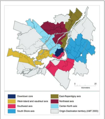
Three criteria were defined to locate the axes of mobility found in the Montréal metropolitan region (MMR): the lay-out of mobility infrastructure (highways, rail lines), munici-pal boundaries, and insight gained from previous research done on the topic. Based on empirical observations, we con-ducted this research essentially on the relationships between certain previously identified territories and mobility flow patterns found on segments of the metropolitan transporta-tion system. We then attempted to validate this experimental result by means of the latest Origin−Destination study on the MMR Agence Métropolitaine de Transport (Metropolitan Transportation Agency; AMT, 2003) that provided us with transport-related data for mapping and for elaborating trip tables at the census tract (CT) level. All trips originating from a CT (all purposes and modes combined) were associ-ated with a destination locassoci-ated along one of the axes. We singled out the following purposes: study, leisure, shopping, health, work, and visits. Each CT was therefore associated with an axis by type of destination. In so doing, an axis was validated when a majority of trips originating on the said ter-ritory ended there as well. This result made it possible to identify six different structural axes outside of the downtown core (Figure 1). These are all leading to the core and are com-posed of various activity and employment growth poles. Out of these seven axes, we selected the Center-North axis to conduct a more comprehensive study.
Taking as a starting point, the previously outlined metro-politan area axial structure, and considering Montréal’s Center-North axis in particular, we decided to conduct a tele-phone survey with the aim of collecting data on daily and residential migrations and exploring the interactions between them. The Bureau des interviewers professionnels, a
well-known local survey research firm, carried out the survey. The territory for the survey was the Center-North axis and postal codes served in the study design as population selec-tion criteria. The firm used its own method to generate a rep-resentative population sample. The goal was to collect 500 completed survey questionnaires. It should be mentioned that a filter question was asked to disqualify potential respondents who did not meet our residential history criteria. To qualify, the respondent must have lived in two different homes during their life, including with their parents, anywhere in Montréal’s CMA. We limited the number of questions to keep the dura-tion of the interview to 7 or 8 min. We are fully aware that asking people to remember the exact address of every one of their homes during their life is a difficult task. Therefore, we targeted only two past residential locations in addition to their present address already identified: the neighborhood where they were raised and the home they occupied before the cur-rent one. Respondents were asked the same questions about their parents’ home (if alive, and as the case may be, father and mother separately), as well as about their adult children who no longer live with them (maximum of two). The loca-tion of their workplace and of their usual shopping and movie theater destination was also identified. A set of questions pro-vided information on their socioeconomic status (age, type of household, income). The data were primarily used to distin-guish variations in daily and residential behavior patterns. Figure 1. The seven axes of mobility and the downtown core of the Montréal Metropolitan Region.
A Case Study of the Residential Trajectories in
the Center-North Axis
In light of our analysis of the Origin−Destination dataset, the Montréal metropolitan area axial structure includes sectors that branch out from the central city neighborhoods and spread outward toward the first and second belts. Montréal’s particular geographic layout, an archipelago, facilitates the identification of three territorial subsets, which we call sec-tors and which correspond to the three phases of metropoli-tan development: These are the neighborhoods of the Center-North area of Montréal, the central area of the City of Laval, and the northern belt found on the North Shore. Two rivers spanned by bridges separate the three territorial units. Bearing in mind this configuration of the Center-North axis of the CMA, it is interesting to consider the trajectories of residents living today in each of the three sectors (Figure 2).
With the residential history data related to the respon-dent’s past locations at our disposal, we began by trying to determine the number of locations found along the axis (1, 2, or 3). Respondents who mentioned only one location in the axis, obviously their current home, were referred to as new-comers. We placed respondents who indicated two locations in two categories. The first are those who lived in the axis during their childhood, moved out, but have since returned, while the second did not grow up in the territory of the axis but have been living there since their previous home. For technical reasons (i.e., conducting telephone interviews within the set time limit), the total duration of the time during which the respondent has been living in the area was not addressed. In spite of this, we consider that by identifying the
three locations, each person’s residential history can be established fairly well.
Table 1 shows that more than one third of respondents have no personal residential history in the territory of the axis, while 44% mentioned two homes in the axis. Finally, 21% of respondents claim having lived in three separate locations in the axis (see Table 1). Besides, more than one third of them have no ties with the territory going back to their childhood days. Only 28% of respondents can claim to have had such a long tie.
We then proceeded to distinguish the behavior patterns found in the axis’ three sectors, namely northern Montréal, the center of Laval, and the North Shore. Differences become apparent in terms of the stability of suburban residents (Laval and North Shore) who are proportionately more likely (70%) to have a history in the territory of the axis than are Montréal residents (50%). Only 12% of the central city sector resi-dents declared having lived in three homes within the axis compared with 23% of Laval and 28% of North Shore resi-dents (Table 1). These responses seem consistent with typi-cal patterns of residential behavior. People living in neighborhoods close to the center are renowned for being more mobile, welcoming more immigrants, and exposed to greater ecological changes occurring in social areas.
The residential mobility behavior of residents in the terri-tory of the axis is tantamount to a strong local attachment. The methodological strategy used did not allow us to verify our initial hypothesis, which entails that residential develop-ment, as a whole, expands in successive waves beginning in the central areas and incrementally toward the suburbs in a leapfrog fashion. According to our data, the average age of respondents was 42 in the Montréal sector, 48 in Laval, and 46 in the North Shore. Their childhood years spanned the 1960s when these neighborhoods, located on the periphery of the central city and in the suburbs, were already in exis-tence although they were new and undergoing expansion at the time. Because of the limited case history data, a render-ing of the residential trajectories across generations was not possible, which should have included the locations tracing back to their parents and even their grandparents.
It is nonetheless interesting to decompose the sequence of locations in each sector (Table 2). By exploring the sequence of residential locations, we can distinguish between those who have two homes in the axis including during childhood (1-0-1) and those without (0-1-1). The objective here is to determine the residential trajectories of respondents that have migrated from one sector to another along the axis.
We conducted a comparison of respondents’ residential histories between those living in the same sector of the axis and those who resided in at least two sectors of the axis. It shows that, to a certain extent, there is a prevailing residen-tial attachment to the axis. In total, 175 respondents declared not having lived in a second sector of the axis, which repre-sents 65% of those who have prior experience living in the axis and 42% of all respondents (including respondents with Figure 2. The Center-North Axis.
only one home in the axis). Those who lived in two sectors of the axis represent 23% of all respondents. We should men-tion that only one respondent claimed to have lived in all three sectors.
For the remainder of this paper, the term “Entrenched” is used to refer to those who have resided in two or three homes in the same sector of the axis. “Movers” lived in two separate sectors of the axis. “Newcomers” are those who are currently living in the axis, but whose two previous homes were located outside the axis.
The Socioeconomic Characteristics
Which ecological features, if any, are unique to each cate-gory of residents living in the Center-North axis? The limita-tions of our telephone survey method, in particular, the time constraints for conducting interviews, and the reduced num-ber of questions that could be asked, meant that we had to keep the number of questions concerning socioeconomic sta-tus to a strict minimum. For this survey, we therefore focused on the age of respondents, household structure, and income. Table 2. Residential History by Type of Resident in the Center-North Axis.
“Entrenched” (two or three homes in only one
sector of the axis)
“Movers” (two or three homes in at least two
sectors of the axis)
“Newcomers” (present-day residents in the axis with two
previous homes outside axis) Total
Number of homes in the axis N % N % N % N %
Three 55 31 33 35 0 0 88 21
Two (1-0-1) 16 9 13 14 0 0 29 7
Two (0-1-1) 104 60 48 51 0 0 152 37
One 0 0 0 0 148 100 148 35
Total by type 175 100 94 100 148 100 417 100
Total number of respondents 42 23 35 100
Source. Bureau des intervieweurs professionnels and Institut National de la Recherche Scientifique—Urbanisation Culture Société, 2008. Table 1. Number of Residential Locations in the Center-North Axis of Survey Respondents.
Total Montréal Laval North Shore
Number of homes in the axis N % N % N % N %
Three 88 21 16 12 34 23 38 28
Two 181 44 51 38 69 47 61 44
One 148 35 66 50 43 30 39 28
Total 417 100 133 100 146 100 138 100
Source. Bureau des intervieweurs professionnels and Institut National de la Recherche Scientifique—Urbanisation Culture Société, 2008. Note.χ2= 26.2, d.o.f. (degrees of freedom) = 6, p< .001.
Table 3. Distribution by Age Group of Respondents.
Two or three homes in the axis
In one sector only In two sectors Only the current home in the axis Total
Age group N % N % N % N %
18 to 34 years 44 25 14 15 45 31 103 25
35 to 49 years 69 39 51 54 42 29 162 39
50 to 59 years 33 19 11 12 18 12 62 15
60 years and more 29 17 18 19 40 28 87 21
Total 175 100 94 100 145 100 414 100
We found that, broadly speaking, the population surveyed is relatively young with one third of respondents under the age of 35 and only 10% more than the age of 65 (18% more than 60). The axis is home in large part to family households (62% living with spouse or partner, of which 38% have chil-dren). Only 9% of respondents are single-parent households. Slightly more than 20% of households earn less than CAN$30,000 per year and can be regarded as poor. At the other end of the economic spectrum, 37% of households declared an income in excess of CAN$60,000. These find-ings are a reflection of typical households living in periurban and suburban neighborhoods, that is, family households earning decent incomes (data not shown).
By comparing the data obtained on the socioeconomic profiles of respondents, sorted by residential trajectories, we found marked differences between those who migrated from one sector to another along the axis. Here, respon-dents who mentioned having lived in two sectors of the axis form a specific type. Chi-square tests show that only age and household status (i.e., with or without children) are sig-nificant. The largest and most representative group of our sample is composed mostly of respondents with a strong local attachment. This finding is clearly a reflection of the population’s profile. More than half of the respondents aged 50 and above belong to the entrenched group. Their residential history in the axis is characterized by having lived in at least two homes located in the same sector.
Respondents who mentioned living in two sectors of the axis (the movers) are slightly younger than the previous group, with 54% between the ages 35 and 49 (Table 3).
The distribution of the three categories of residential his-tory varies according to household composition (Table 4). The movers accounted for the largest proportion of house-holds with children living at home (60%). They contrast sharply with the newcomers composed of the same propor-tion (61%) of households without children.
The Residential Trajectories of Family Relatives
Can residential migrations reflect the influence that each family member exerts on the other members? To answer this question, respondents were asked to identify the current location of their parents’ and their children’s homes, if they lived elsewhere. Fathers and mothers could have two sepa-rate addresses. Moreover, due to the time constraints in con-ducting the telephone interviews, we limited the number of children to two. Therefore, in our survey, a parent or a child represents one home (Table 5). As a result, it is not clear which relative did in fact influence the trajectories: It could very well be that a child decided to live near their father or mother, or that a parent wanted to live closer to the child. In any case, we continue to maintain that the likelihood of a shared identity is reflected by parents and children living in the territory of the axis or in the same sector.
Table 4. Distribution by Presence of Children in Household.
Two or three homes in the axis
Only the current
home in the axis Entrenched and Movers Total
Household types Entrenched Movers Newcomers In one sector only In two sectors N %
Household without child 90 54 36 85 61 211 53
Household with child(ren) 78 46 55 54 39 187 47
Total 168 100 91 139 100 398 100
Source. Bureau des intervieweurs professionnels and Institut National de la Recherche Scientifique—Urbanisation Culture Société, 2008. Note.χ2=
10.3, d.o.f. (degrees of freedom) = 2, p< .01.
Table 5. The Residential Trajectories of Parents.
Parents living within the axis Parents living outside the axis
Location of
parents Total within the axis
Same sector than respondent
Other sector than
respondent Total
CMA outside axis
Outside CMA
Respondents N % N % N % N % N % N % N %
Entrenched 143 100 67 47 61 43 6 4 76 53 23 16 53 37
Movers 83 100 43 52 15 18 28 34 40 48 21 25 19 23
Newcomers 117 100 13 11 9 8 4 3 104 89 41 35 63 54
Total 343 100 123 36 85 25 38 11 220 64 85 25 135 39
Overall, 36% of parents currently reside in the axis and more than two thirds of them live in the same sector as the respondents (their child or children). This level of rootedness in the territory by parents is proportionately similar for the entrenched (47%) and movers (52%), whereas this proportion falls to only 11% for newcomer parents. It is noteworthy that the number of parents of movers living in the territory of the axis or outside of it is the same. While the proportion of par-ents of the entrenched is slightly lower within the axis, they are more inclined to live in the same sector as the respondents (their child or children). The profile of parents of newcomers is different, with about 89% of them living outside of the ter-ritory of the axis, of which 61% live outside of the CMA.
What is the situation of the children identified by respon-dents who have left the family nest? Responrespon-dents who are parents were asked to identify the residential locations of their adult children. The proportion of children of respon-dents living within the boundaries of the axis is relatively high, nearly 40%, of which about a third (34%) are still liv-ing in the same sector. Generally, children who live in the axis do so in the same sector as the respondent. As expected, this profile is more common among movers. An equal pro-portion of children of movers display territorial attachment or elect to reside outside the axis, while half of them have found a home in the same sector as their parents. The propor-tion of children of newcomers living outside of the axis is more than two thirds (Table 6).
A similar proportion of relatives of the entrenched and of movers currently live in a home located within or outside the
axis. Residential migration across sectors is marginal, as only 11% (parents) and 6% (children) move to a new loca-tion in another sector of the axis. Family members of new-comers develop different behavior patterns, with 60% of children and 64% of parents living outside the axis. As the preexisting relation between respondents and their relatives somewhat muddles the premise that the responses are inde-pendent of each other, our analysis relied on just one obser-vation per respondent. If a respondent were to identify more than one address for their parents (in the case of separated parents) or their children, then we defined two categories to examine home locations: the first is when at least one parent or one child live within the axis, and the second is when both live outside the axis.
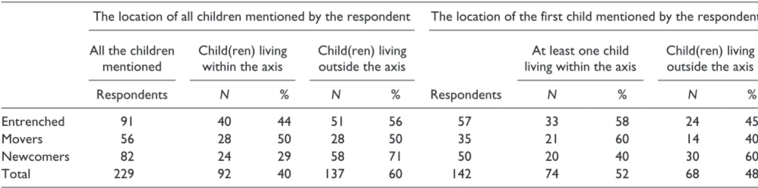
The overall trend is clear: If we consider the 343 parents instead of examining the data on the 274 respondents (Table 7), the findings would be consistently the same (data not shown). This is however not the case with children. Concerning only the 142 respondents with children living outside the family home (Table 8), the evidence does not allow us to conclude that the spatial distribution of children varies according to the type of parent (p > .1). In spite of this, after conducting a statistical test on all 229 children mentioned by respondents, we found that the location of children does in fact vary (p= .033) according to whether the parent is entrenched, a mover, or a newcomer (Table 8). The situation in this case differs because most children of newcomer parents live outside of the territory of the axis (even though Table 7 shows nonsig-nificance) and that these parents tend to have two or more Table 6. The Residential Trajectories of Children.
Children living within the axis Children living outside the axis
Location of children
Total within the axis
Same sector as respondent
Other sector than
respondent Total CMA outside axis Outside CMA
Respondents N % N % N % N % N % N % N %
Entrenched 91 100 40 44 39 43 1 1 51 56 32 35 19 21
Movers 56 100 28 50 21 37 7 13 28 50 16 29 12 21
Newcomers 82 100 24 29 18 22 6 7 58 71 36 44 22 27
Total 229 100 92 40 78 34 14 6 137 60 84 37 53 23
Source. Bureau des intervieweurs professionnels and Institut National de la Recherche Scientifique—Urbanisation Culture Société, 2008.
Table 7. The Location of Parents by Type of Respondent.
At least one parent living within the axis Parent(s) living outside the axis
Respondents N % N %
Entrenched 114 60 53 54 47
Movers 65 39 60 26 40
Newcomers 95 13 14 82 86
Total 274 112 41 162 59
children. Thus, the greater number of children help tip the balance by doubling the statistical weight of these respon-dents. No significant differences were found regarding the location of children between the movers and entrenched groups.
Residential patterns of settlement indicate that without a strong attachment to the axis or to one of the three sectors, the generational transmission of a tie to the territory remains uncertain. Children and parents chose their homes more randomly. Yet, despite the relative insignificance of the axis’ role in the residential structure, the very fact that a respondent’s residential history is well rooted in one of the sectors of the axis does have some bearing on the residen-tial choices of parents and children. It is impossible how-ever to determine whether it is the child or the parent who is attracting the other. In sum, residential history across a given territory produces a self-image based on one hand on familiarity with the various settings encountered in daily life, and on the other hand, on patterns of settlement within a particular sector. On comparing the entrenched and mov-ers, we found that generational co-influence, when it hap-pens, favors a particular residential sector. Essentially, migration between sectors inside the axis can be described as a marginal phenomenon (Tables 5 and 6).
Finally, it can be argued that the axial structure plays a determining role in the residential trajectories of respondents (see Figure 1). In this case, each line indicates a single trajec-tory starting from the respondent’s childhood neighborhood and ending at their current home.
Daily Mobility
Respondents were asked to describe regular trips made from home to their workplace, regular shopping area, and movie theater. The analysis thus focused on three daily destinations, each having distinct purposes. Trips can be completed near the home, in the three sectors of the axis, or across the met-ropolitan area. The compilation shows that the trips are made, for all purposes combined, for 66% within the Center-North axis (Figure 3). The data provided insight into the
relative weight of local attachment for such spatial practices and the interactions between the three sectors of the axis.
The strong relationship between daily mobility practices and local attachment was not surprising. Given equal condi-tions, everyone will rationally plan their trips by considering the shortest route to their various destinations (Table 9).
The evidence here is clear. For shopping purposes, 83% of respondents identified a commercial street or a mall located in the territory of the Center-North axis. Moreover, 74% of respondents confirmed that their regu-lar shopping destination is somewhere in their residential Table 8. The Location of Children by Type by Respondent, All Children (n= 229) and Only One Child (n= 142).
The location of all children mentioned by the respondent The location of the first child mentioned by the respondent
All the children mentioned
Child(ren) living within the axis
Child(ren) living outside the axis
At least one child living within the axis
Child(ren) living outside the axis
Respondents N % N % Respondents N % N %
Entrenched 91 40 44 51 56 57 33 58 24 45
Movers 56 28 50 28 50 35 21 60 14 40
Newcomers 82 24 29 58 71 50 20 40 30 60
Total 229 92 40 137 60 142 74 52 68 48
Note.χ2=
6.8, d.o.f. (degrees of freedom) = 2, p= .033; χ2=
4.6, d.o.f. (degrees of freedom) = 2, p= .1015.
Figure 3. Destinations of residents of the axis for all purposes combined.
sector within the axis. By contrast, it is more difficult to live and work in the same sector. The workplace of nearly half of respondents (48%) is located in the territory of the axis. More specifically, 37% of respondents work in their residential sector. A trip to the movies usually implies more freedom of choice regarding the location of the the-ater and film genre. Even so, 60% of respondents said they often see movies being screened at theaters located in the territory of the Center-North axis, while 50% selected a movie in their sector (Table 9). To some extent, the weight of the axis bears on the choice of destination, as it represents 48% of work-related trips, 83% of shopping, and 60% of outings to a movie theater. However, interac-tions across the axis, for all three purposes, level off at 10%. In other words, attachment to one’s residential sec-tor is the dominant facsec-tor within the spatial structure of destinations.
The variations in behavior patterns of the three categories of respondents regarding daily trips are relatively small and not significant (p > .05). For work-related trips, the three cat-egories showed a similar attachment to the territory as roughly 50% work within the axis. While movers are slightly more likely to work in another sector of the axis, few respon-dents in all categories choose either a shopping area or a movie theater located in another sector of the axis. The work-place of approximately 20% of movers is located elsewhere within the axis than their home sector, while this is the case for slightly less than 10% of the entrenched and of newcom-ers. Beyond that, there are no other variations of note, as locations in another sector than the place of residence remain below the 10% mark.
Mapping of the respondents’ main destinations produces an interesting pattern (Figure 4). It should be noted that we incorporated each respondent’s regular trips to the grocery
store. The map illustrates the convergence of places of work, shopping, and leisure and their role as poles of attraction for residents within their own sector.
Conclusion
Montréal, like other North American metropolitan areas today, is built around a set of diversified and autonomous suburban places (Hanlon et al., 2006). Clearly, the center no longer exerts a perpetual attractive power on its periphery Table 9. Daily Mobility to the Workplace, Shopping Area, and Movie Theater.
Within the axis
Categories of residents All Same sector Other sector Outside the axis
Destination N % N % N % N % N %
Workplace Entrenched 131 100 63 48 51 39 12 9 68 52
Movers 75 100 37 49 22 29 15 20 38 51
Newcomers 104 100 50 48 42 40 8 8 54 52
Total 310 100 150 48 115 37 35 11 160 52
Shopping area Entrenched 167 100 136 81 121 72 15 9 31 19
Movers 86 100 80 93 71 83 9 10 6 7
Newcomers 133 100 106 80 92 69 14 11 27 20
Total 386 100 322 83 284 74 38 10 64 17
Movie theater Entrenched 143 100 76 53 65 45 11 8 67 47
Movers 78 100 54 69 46 59 8 10 24 31
Newcomers 116 100 72 62 58 50 14 12 44 38
Total 337 100 202 60 169 50 33 10 135 40
Source. Bureau des intervieweurs professionnels and Institut National de la Recherche Scientifique—Urbanisation Culture Société, 2008.
Figure 4. Sectors visited by residents of the Center-North axis (purposes: food shopping, cinema, commercial street or mall, and workplace).
that is identical throughout the suburban area. Nowadays, only a fraction of commuter flows are directed toward the Convention on Biological Diversity (CBD) of Montréal. In the case of the Center-North Axis, households heading to the downtown core generate only 17% of trips.
It is apparent from our study that the axis is composed of a constellation of central places situated on either side of a highway that channels flows and migrations. The axis links different poles of employment with areas for other activities similar to those described in the recent literature (Burger & Meijers, 2012; Filion & Kramer, 2012; Modarres, 2011).
The process of succession at the heart of Burgess’s model, which predicted an outward movement from the center to the periphery, is replaced by multiple mobilities generated around existing secondary growth poles concentrating jobs, civic amenities, and shopping opportunities. The results from our survey show that practices of daily mobility take place in the immediate area surrounding the home. The same holds true for residential migration. For most residents, the sector where they live today and spent their childhood is the same. Their home, workplace, and other destination points are all located in the sectors where a large part of commutes and other daily travel originate.
Our study demonstrates the existence of an attachment to the territory of the axis and, more certainly, to its sectors. What stands out is the strong image of well-established sec-tors sustained over time by the mutual influence of parents and their children. The image calls to mind the sector theory, which does not draw on Homer Hoyt’s gradient of land val-ues, but rather on daily mobility and residential migrations. These stable and diversified sectors are freed from the attrac-tion of the center without entirely being disconnected from it. The evolution toward a polycentric metropolis is indeed being fulfilled with the increase in mobility. As Burger et al. (2011) noted, intraregional flows and the density of exchange networks are fostering the growth of secondary centers along the axis. The Center-North axis is seen as an example of the new North American urban morphology (Lang & Knox, 2009) in which the variations in density and connectivity and the role of networks are helping to form diversified and spe-cialized secondary centers. In a sense, this gives credence to the claim that the suburb has entered the final phase of the urbanization process. In the current debate on metropolitan area models (Conzen & Greene, 2008; Mollenkopf, 2008), we can assert that the polycentric metropolis is composed of poles and peripheral sectors that are sufficiently well struc-tured to enable residents of each sector to develop an attach-ment and ensure its intergenerational transmission.
Without fully applying a time−space geography perspec-tive, what we found are not prisms of mobility but instead, series and bundles unfurling toward poles of employment, shopping malls and commercial streets, and movie theaters. For whatever the purpose, 60% of trips take place within the axis, while only 10% of all trips within the axis are intended for areas located outside of the residential sector where they originated. Finally, the means of expressing attachment can
vary. The sense of belonging to a sector begins early in child-hood for a large number of respondents. It should be noted that our methodology does not provide data on the history of residential migrations. To produce evidence-based results, life span longitudinal studies could more accurately focus on the intergenerational residential patterns and trajectories start-ing from the postwar period up to the present.
One more point should be made about the sectors. They are portrayed as an ecological structure with various shades of meaning that reveal the significance of lifestyles. Seen in this light, the type of household, by playing a major role in the residential location selection process particularly when children are involved, may be considered as a key factor in decisions regarding commitment to the same sector when moving.
Returning to the axial hypothesis, if the axis no longer forms a continuous corridor directly influencing daily trips and residential migrations, it acts instead as a reference for residents of the different sectors. Such results suggest the importance of reproducing territorial linkages, especially within the sectors and, to a lesser degree, along the axis itself. By focusing our attention on the relation between the two types of mobility, we have found that the metropolis is capable of combining attachment and mobility. The axial structure is associated with busy and lively corridors com-prising places and poles whose critical function is bridging and not “fragmenting” the metropolitan territory.
Declaration of Conflicting Interests
The author(s) declared no potential conflicts of interest with respect to the research, authorship, and/or publication of this article.
Funding
The author(s) disclosed receipt of the following financial support for the research and/or authorship of this article: The authors are grateful to the Fonds de Recherche du Québec Société et Culture for its financial support.
References
Adams, J. S. (1969). Directional bias in intra-urban migration.
Economic Geography, 45, 302-323.
Batty, M. (2001). Polynucleated urban landscapes. Urban Studies,
38, 635-655.
Beauregard, R. A. (2006). When America became suburban.
Minneapolis: University of Minnesota Press.
Beauregard, R. A. (2007). More than sector theory: Homer Hoyt’s
contributions to planning knowledge. Journal of Planning
Theory, 6, 248-271.
Buliung, R. N., & Kanaroglou, P. S. (2006). Urban form and
house-hold activity-travel behavior. Growth and Change, 37, 172-199.
Burger, M. J., de Goei, B., van der Laan, L., & Huisman, F. J. M. (2011). Heterogeneous development of metropolitan spatial structure: Evidence from communing pattern in English and
Welsh city-regions, 1981-2001. Cities, 28, 160-170.
Burger, M. J., & Meijers, E. (2012). Form follows function?
Linking morphological and functional polycentricity. Urban
Burgess, E. W. (1925). The growth of the city: An introduction to a
research project. Publication of American Sociological Society,
22, 178-184.
Burgess, E. W. (1967). Can neighbourhood work have a
scien-tific basis? In R. E. Park, & E. W. Burgess (Eds.), The city
(pp. 142-155). Chicago, IL: University of Chicago Press. Clark, W. A. V. (2000). Monocentric to polycentric: New urban
forms and old paradigm. In G. Bridge, & S. Watson (Eds.), A
companion to the city (pp. 141-154). Oxford, UK: Blackwell. Clark, W. A. V., Huang, Y., & Withers, S. (2003). Does commuting
distance matter? Commuting tolerance and residential change.
Regional Science and Urban Economics, 33, 199-221. Conzen, M. P., & Greene, R. P. (2008). Introduction: All the world
is not Los Angeles, nor Chicago: Paradigms, schools,
arche-types and urban process. Urban Geography, 29, 97-100.
De Certeau, M. (1984). The practice of everyday life. Berkeley:
University of California Press.
Ellegard, K. (1999). A time-geographical approach to the study of everyday life of individuals: A challenge of complexity.
GeoJournal, 48, 167-175.
Filion, P., & Kramer, A. (2012). Transformative metropolitan development models in large Canadian urban areas: The
pre-dominance of nodes. Urban Studies, 49, 2237-2264.
Glaeser, E. L., & Kahn, M. E. (2001). Decentralized employment
and the transformation of the American City (Working Paper No. 8117). Cambridge, MA: National Bureau of Economic Research.
Golledge, R. G. (1975). Learning about urban environments. In
T. Carlstein, D. Parker, & N. J. Thruft (Eds.), Making sense of
time (pp. 76-98). New York, NY: John Wiley.
Gordon, P., & Richardson, H. W. (1996). Beyond polycentricity:
The dispersed metropolis, Los Angeles, 1970–1990. Journal of
American Planning Association, 62, 289-295.
Green, N. (2007). Functional polycentricity: A formal definition
in terms of social network analysis. Urban Studies, 44,
2077-2103.
Hägerstrand, T. (1970).What about people in regional science?
Papers of the Regional Science Association, 24, 7-21.
Hägerstrand, T. (1975). Space, time and human condition. In
A. Karlqvist (Ed.), Dynamic allocation of urban space (pp. 3-12).
Farnborough, UK: Saxon House.
Hanlon, B., Vicino, T., & Short, J. R. (2006). The new
metropoli-tan reality in the US: Rethinking the traditional model. Urban
Studies, 43, 2129-2143.
Harris, C. D., & Ullman, E. L. (1961). The nature of cities. In
P. K. Hatt, & A. J. Reiss, Jr. (Eds.), Cities and society: The
revised reader in urban sociology (3rd ed., pp. 237-247). New York, NY: The Free Press of Glencoe.
Hoyt, H. (1939). The structure and growth of residential
neighbor-hoods in American cities. Washington, DC: Federal Housing Administration.
Isard, W. (1960). Methods of regional analysis. Cambridge, MA:
MIT Press.
Isard, W., & Liossatos, P. (1979). Spatial dynamics and optimal
space-time development. New York, NY: The North-Holland Publishing Company.
Landry, J. (2006). La mobilité intra-urbaine dans le corridor de
Repentigny vue du registre foncier [Intraurban mobility in the Repentigny corridor from landtax register], Mémoire de maîtrise
(Master’s in urban studies). Montréal, INRS-Urbanisation Culture Société.
Lang, R., & Knox, P. K. (2009). The new metropolis: Rethinking
megalopolis. Regional Studies, 46, 789-802.
Lee, B. (2007). Edge or edgeless cities? Urban spatial structure in
U.S. metropolitan areas, 1980 to 2000. Journal of Regional
Science, 47, 479-515.
Lynch, K. (1960). The image of the city. Cambridge, MA: MIT
Press.
Meijers, E. (2005). Polycentric urban regions and the quest for syn-ergy: Is a network of cities more than the sum of the parts?
Urban Studies, 42, 765-781.
Modarres, A. (2011). Polycentricity, commuting pattern, urban
form: The case of Southern California. International Journal
of Urban and Regional Research, 35, 1193-1211.
Mollenkopf, J. (2008). School is out. The case of New York City.
Urban Affairs Review, 44, 239-265.
Orfield, M. (2002). American metropolitics: The new suburban
reality. Washington, DC: Brookings Institution Press.
Parr, J. (2004). The polycentric urban region: A closer inspection.
Regional Studies, 38, 231-240.
Paulsen, K. (2012). Yet even more evidence on the spatial size of
cities: Urban spatial expansion in the US, 1980-2000. Regional
Science and Urban Economics, 42, 561-568.
Pred, A. (1977). The choreography of existence: Comments on
Hägerstrand’s time-geography and its usefulness. Economic
Geography, 53, 207-221.
Scheller, M., & Urry, J. (2006).The new mobilities paradigm.
Environment and Planning A, 38, 207-226.
Sohn, J. (2005). Are commuting patterns a good indicator of urban
spatial structure? Journal of Transport Geography, 13, 306-317.
Vicino, T. J. (2008). The spatial transformation of first-tier sub-urbs, 1970 to 2000: The case study of metropolitan Baltimore.
Housing Policy and Debate, 19, 479-518.
Vicino, T. J., Hanlon, B., & Short, J. R. (2007). Megalopolis 50 years
on: The transformation of a city region. International Journal
of Urban and Regional Research, 31, 344-367.
Author Biographies
Gilles Sénécal is an associate professor of urban studies at Centre Urbanisation Culture Société, Institut National de la Recherche Scientifique (Université du Québec).
Pierre J. Hamel is a research professor at Centre Urbanisation Culture Société, Institut National de la Recherche Scientifique (Université du Québec). He works mainly on local public finance.
Jean-Pierre Collin is full professor of urban studies at Centre Urbanisation Culture Société, Institut National de la Recherche Scientifique (Université du Québec).
Nathalie Vachon is social science analyst at Centre Urbanisation Culture Société, Institut National de la Recherche Scientifique (Université du Québec).
Kathryn Jastremski is a PhD candidate in the program of social and ecological sustainability in the Department of Environment and Resource Studies of the University of Waterloo.