1
Instituto Politécnico de Tomar – Universidade de Trás-os-Montes e Alto Douro
(Departamento de Geologia da UTAD – Departamento de Território, Arqueologia e Património do IPT)
Master Erasmus Mundus em QUATERNARIO E PRÉ-HISTÓRIA
The lithic assemblage of the US 13 at the
Middle Paleolithic site of Oscurusciuto
(Ginosa, Taranto, Southern Italy):
Technological studies.
Giulia Marciani
Orientadores: Prof. Claire Gaillard
Prof. Annamaria Ronchitelli
Co Orientadores: Dott. Daniele Aureli
PhD student Filomena Ranaldo
2 INDEX
INTRODUCTION ... 4
1. PHYSICAL SETTING OF THE REGION OF GINOSA, TARANTO ... 5
1.1LOCALIZATION AND GEOMORPHOLOGY ... 5
1.2 GEOLOGY ... 6
1.3 HYDROLOGY, CLIMATE AND VEGETATION ... 10
1.4 HUMAN OCCUPATION ... 12
2. OSCURUSCIUTO ROCKSHELTER ... 19
2.1 DESCRIPTION OF THE SITE ... 19
2.2HISTORY OF THE EXCAVATION ... 21
2.3 STRATIGRAPHY AND CHRONOLOGY ... 22
2.4 WATER ACTION ON THE ROCKSHELTER ... 25
2.5 METHOD OF EXCAVATION AND DOCUMENTATION ... 26
2.7US13 AND PALEOENVIRONMENT ... 26
3. LITHIC INDUSTRIES OF THE US 13... 30
3.1 THE LITHIC MATERIAL... 30
3.2OBJECTIVES OF THE STUDY ... 31
3.2 THEORY AND METHODOLOGY ... 32
3.3DATA COLLECTION AND STUDY ATTRIBUTES ... 36
3.3.1THE MINIMUM ANALYTICAL NODULES ANALYSIS: PROCEDURE AND STUDY ATTRIBUTES ... 36
3.3.2 TECHNOLOGICAL ANALYSIS: PROCEDURE AND STUDY ATTRIBUTES ... 43
3.4 TECHNOLOGICAL ANALYSIS ... 57
3.4.1INTRODUCTION ... 57
3.4.2RAW MATERIAL AND PHYSICAL STATE OF THE INDUSTRY ... 59
3.4.4 CORES ... 62
3.4.6 PEBBLES... 120
3.4.7DEBRIS ... 121
3.4.8 INDETERMINATE ITEMS ... 124
3.4.9RMU: RAW MATERIAL UNITS ... 125
3.4.10COMPARATIVE ANALYSIS TECHNOLOGY AND RMU ... 127
3.5 TECHNOLOGICAL COMPOSITION AND CHAINE OPERATOIRE OF THE INDUSTRY OF US 13 ... 128
3
5 COMPARISONS IN THE SITE AND IN THE REGION ... 135
5.1OTHER LEVEL OF THE SITE ... 135
5.2THE REGION OF PUGLIA ... 137
6 FINAL CONSIDERATION AND FUTURE PROSPECTIVE ... 138
List of tables ... 141
List of figures ... 142
4 INTRODUCTION
This work deals with the research potential of lithic materials through the case study of a level of Oscurusciuto rockshelter.
Flaked lithic materials, because of their durability, represent one of the most abundant artefact classes ever found in archeological sites. The lithic artefacts preserve also traces of the actions that have been carried out on them. For these reasons stone artefacts are one of the most important data sources for understanding prehistoric human behavior.
This master thesis has the purpose of studying the technical devices owned by Neandertal population in the Southern region of the Italian peninsula.
We consider the period between 40.000 and 55.000 BP because it proves of particular interest especially for the dynamic of human occupation, and for the management of the area by the resident human population. The explaination lies in the fact that during this period both the last occupation of Neandertal and the first settlement of Modern humans in Europe have taken place.
The site we choose for this study is the Oscurusciuto rockshelter, localized in the region of Puglia (municipality of Ginosa, province of Taranto). The region, during the Musterian, had a particular context according to its location in the far South-East of Italy. Moreover, the Oscurusciuto site is located in the middle part of Puglia and therefore it stands at a crossroad of different areas of the south of Italy: the south (the Salento) and north of Apulia (the area of Murge the Gargano peninsula) and ,finally, the area of the Gulf of Taranto and Basilicata.
The choice of the level US 13 was targeted in particular at the possibility of presenting an integrated study in order to understand the technological behavior expressed by Human groups living in this site considered also in their spatial context.
We intend to reach this purpose by: the description of the economic behavior as far as regards the acquisition and the exploitation of raw material and the production of lithic tools; the identification of the Chaine operatoire, which means to check the different stages of the lithic production that are cortex removal, management, production, transformation by retouch, utilization and abandon; the definition of concepts, methods, dynamics and objectives of débitage.
Understanding the chaine operatoire means getting the ability of putting each single artefact into the sequence of the technical operations, actions and choices made by the knapper i.e., to practically go back to the real purpose that probably the original craftsman had pursued.
5
smallest unit, the single pebble, that means identify technical events in order to get informations about the segmentation of the chaine operatoire. A special focus has been given to the study of cores and the numerous refitting and conjoin.
Finally the technical aspect of the industry was considered in relation to the spatial context in which each single piece was found.
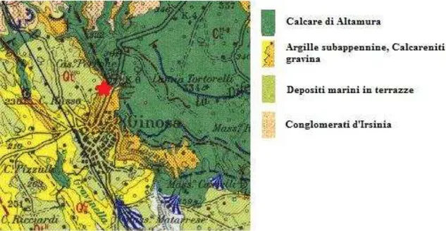
1. PHYSICAL SETTING OF THE REGION OF GINOSA, TARANTO 1.1 LOCALIZATION AND GEOMORPHOLOGY
Ginosa is a municipality situated in the Southern part of Italy in the region of Puglia, province of Taranto. Its surface covers almost 190,06 km2 comprehending also the Ionic costal line
of Marina di Ginosa. It is situated around 40°30 0” latitude North and 16°45 0 longitude East.
The region Puglia for its different geomorphological features can be divided into 3 parts: the northern part, corresponding to the Gargano promontory, the central-northern part represented by the plain of the Tavoliere and the plateau of Murgia and, finally, the southern part referred to the Salento peninsula.
The Gargano promontory presents a mountainous morphology that reaches its maximum pitch with 1,065 m.s.l.m. of Monte Calvo. The Tavoliere is an extensive plain that is connected to the Salento penisola through the plateau of Murgia that corresponds to a square-shaped karst plateau which has its greatest peach on the North-West area.
The municipality of Ginosa stands in the Southern part of Murgia, the so-called Murge Tarantine. Here there are a great example of ravines, which are crevice shaped valleys, even more than 100 m deep, dug in the limestone, with steep walls, distant from each other up to 200 m, which collects water only during rainy seasons. The ravine of Ginosa (Gravina di Ginosa) is part of a protected natural area.
6
The ravine has local names, they are knowed as : Valle dell'Arciprete l'Oscurusciuto, Canale San Giuseppe, Torrente Lagnone Tondo, Canale il Palombaro, Torrente Gravinella, Canale Cecera, Selva Venusio, La Difesella, Gravina Grande, Passo di Giacobbe, Gravinella di Cavese e Canale San Pellegrino, Fosso dell'Alloro e Gravinella del cacciatore.
One of them, Valle dell’Arciprete l’Oscurusciuto, is a particular interest because here it is attested the prehistoric site of Oscurusciuto that it’s the object of this dissertation.
The Oscurusciuto rockshelter is located 20 km from the current ionic coast line at 225 m above the sea level.
1.2GEOLOGY
Briefly, the ravine opens into Mesozoic limestone, on its top have been found formations of Quaternary calcarenite. Starting from the last part of the early Pleistocene, progressive uplift caused the formation of paleorivers which progressively incise the Murgian edge, so creating a deep and narrow valley (ravine).
On a closer inspection, from the geological point of view, the stratigrafy and litology of the area covers a period of time from upper Cretaceus to Olocene, while the stratification shows a great hiatus from the end of Cretaceus to the beginning of upper Pliocene1.
Here it is presented the sedimentary series beginning from the most ancient:
Calcare di Altamura: calcareous deposits organized in layers and benches biostromali (usually finely calcarenitic); in beds of residual deposits and "crostoni" of reddish limestone or layers brecciformi cemented in ferruginous matrix. These limestones seem to be more dolomitic (or dolomite calcariferous), the roof and the bed of the formation are dark grey. Chronologically, the formation refers to the Upper Cretaceous (Senonian-Maastrichtian).
1
RONCHITELLI ET AL. 2011.
7
This formation is located in outcrop in the area of the Murgia of Matera, Laterza, Castellaneta-Mottola, and Altamura2.
Calcarenite di Gravina: yellowish-white calcarenitic fossiliferus deposits formed of fine powder or available in a more compact form, sometimes with gravel and limestone breccia and irregular hints of layering. The formation is in transgression with angular unconformity on the Limestone of Altamura. Chronologically, it refers to the late Pliocene and early Pleistocene (Calabrian). This formation is located in extensive outcrops in the eastern part of the area (from Palagianello to Statte), on the edge of the Murgia’s plateau, and in an isolated flap on it3.
Argille Subappennine: grey blue clays and marly clays deposit. In certain levels they also appear silty or sandy (the clay rock types are more prevalent at the base of the formation, in the upper part is prevailing the marly fraction, towards the top it is possible to detect a stronger component clay-marly and sandy-calcareus). These deposits occur in shoals of considerable thickness (the stratification is normally absent, it is found where sandy intercalations appears). The formation is in eteropic relation with the Calcareniti of Gravina. Chronologically, it ranks among the late Pliocene and early Pleistocene (Calabrian). Extensive outcrops appear in the hilly interior area (from Montescaglioso to the hills situated on the Western part of Basento river and Matera), partially in the area of Taranto, and North of Mottola 4.
Sabbie di Monte Marano: quartz sands medium and fine-grained, the color range from yellowish gray to yellow-ocher, usually loose, with abundant marine fossils. Rest in accordance on Subappennine Clays. Chronologically, the deposit is referred to the Pleistocene (Calabrian), during the regressive stage of the sedimentary cycle of Fossa bradanica in connection with the phenomena of regional uplift. Outcrops of this formation are found in the upper portions of the highest slops of the tabular hills that characterize the Fossa bradanica 5.
Calcareniti di Monte Castiglione: coarse yellow with pinkish appearance bench type calcareniti (sometimes floury calcareniti and coarse limestone conteining breccia). They come in layers (sometimes in cross-vane arrangement, reflecting a costal sedimentary environment) or banks. The formation is eteropic on the sands of Monte Marano and is
2 AZZAROLI ET AL. 1968, MERLA & ERCOLI 1971, BOENZI ET AL. 1971, DE MARTINIS & ROBBA 1971, BOENZI ET AL. 1976.
3 AZZAROLI ET AL. 1968, MERLA & ERCOLI 1971, BOENZI ET AL. 1971, DE MARTINIS & ROBBA 1971, BOENZI ET AL. 1976.
4 AZZAROLI ET AL. 1968, BOENZI ET AL. 1971, DE MARTINIS & ROBBA 1971, BOENZI ET AL. 1976. 5
8
dated to the Early Pleistocene (Calabrian). It is located in outcrop in a band to the North -North East of the Murgia of Altamura, Santeramo and Gioia del Colle and South-SouthWest of the Murgia of Matera and Laterza and Castellaneta6.
Conglomerato d’Irsinia: the conglomerate consists of pebbles of small and medium size (1 -10 cm), rounded shape embedded in a matrix with rare calcareous sandy-clayey lenses. At the baseline, the matrix presents a whitish color, in surface it is reddish. The pebbles are of various kinds (flint limestone, brecciole nummulitiche, sandstone, jasper, granite and gneiss) and come from deposits interbedded conglomeratic sandstones in the Cenozoic of Lucan Apennines (undifferentiated complex of limestone marl of the "Flysch"). The formation rests directly on the sands of Monte Marano and Calcareniti of Monte Castiglione and lies at an advanced stage of the Pleistocene (Calabrian top-Siciliano baseline). It is located in outcrop at the edge of the Murgia of Matera and Laterza (sometimes transgression on cretaceous limestone)7.
Depositi marini terrazzati: a series of terraced areas arranged at various altitudes. It is possible to recognize a total of eight terraces, elongated parallel to the shore line, sloping towards the sea (the higher ones show pedogenic effects more or less marked). In the southwestern part the terraces are composed of fine-grained or coarse sands (colored yellow ocher, often at cross-bedding), with alternating beds of gravel or flattened lenses or polygenic conglomerates, origin Apennines. The highest deposits of the eastern part consist of calcareniti type bench, while the lower ones are conglomeratic calcareous matrix. The highest terraces are in transgression with an angular unconformity on Clays Subappennine, the lower ones are willing "to cloak". From a chronological point of view, the formation is placed in the middle-upper Pleistocene8.
Depositi Alluvionali Terrazzati: continental deposits products, in conjunction with the Marine terraced deposits, because of changes in the base level of the rivers (linked to the Pleistocene marine regression and phases of standing of the sea). In the valley of Bradano the deposits are related to three separate flood cycles. It usually presents limited thickness and are constituted by gravels with sandy-silty lents or by deposits sandy-pebbly. The alluvial plains of the valley floor are recorded for long stretches and retain traces of ancient alvei9.
6
AZZAROLI ET AL. 1968, MERLA & ERCOLI 1971, BOENZI ET AL. 1971, DE MARTINIS & ROBBA 1971, BOENZI ET AL. 1976.
7 BOENZI ET AL. 1971, BOENZI ET AL. 1976.
8 BOENZI ET AL. 1971, BOENZI ET AL. 1976, BENTIVENGA ET AL. 2004. 9
9
Recent and current deposits: alluvial deposits, Holocene lake and marsh, consisting of brown sands, gravels and black sandy clays10.
Coastal dunes and nowadays beaches: recently cemented sands in loose, arranged in dune cordons of variable amplitude (aligned parallel to the shore), and dissolved in a narrow and continuous line that beards the cost11.
CHRONOLOGY
SEA DEPOSIT CONTINENTAL DEPOSIT
OLOCENE Recent and current deposits
Coastal dunes and nowadays beaches MIDDLE AND
UPPER PLEISTOCENE
Depositi marini terrazzati Depositi alluvionali terrazzati
UPPER PLEISTOCENE
EARLY PLIOCENE
Conglomerati d’Irsinia
Calcareniti di Monte Castiglione Sabbie di Monte Marano
10AZZAROLI ET AL. 1968; MERLA & ERCOLI 1971; BOENZI ET AL. 1971; DE MARTINIS & ROBBA 1971; BOENZI ET AL.1976.
11
MARTINIS & ROBBA 1971; BOENZI ET AL.1971.
10 Argille Subappennine
Calcareniti di Gravina UPPER
CRETACEUS Calcare di Altamura
Table 1 Chronostratigrafic table of the area. 1.3 HYDROLOGY, CLIMATE AND VEGETATION
Beside its geomorphological diversity, Puglia has a temperate-Mediterranean climate, which is characterized by the presence of hot, dry summers and mild winters with only few precipitations. The sea helps to mitigate the climate making the temperature range, daily and annual, modest. Also spring and autumn have mild temperatures closer to those of summer days.
The summer months are characterized by drought due to the warm and dry tropical air masses which dominates the Mediterranean basin. The winter and autumnal months have frequent cloud cover and relatively abundant rainfall, and bring typically scirocco winds, alternated with calm and rather cold periods caused by cold northerly winds of Northeast. In spring, it is also present current from Southwest, that brings hot and stuffy air from Africa.
Rainy days are scarce: their number is between 60 and 80 a year. Snow is fleeting except for the Gargano and the Sub Apenninoes Dauno. The region receives an average of a little more than 600mm of rain per year. Precipitations are focused in the winter months, while during the summer season rainfall is almost absent except for violent showers with peaks of 30-50mm in a few minutes. Finally, it is possible to register an elevated inter-annual variability of rainfall12 .
The Puglia’s landscape is dominated by limestone outcropping almost everywhere covered with rock formations or strata more or less subtle of farmland. Just this karst nature, typical of such a land makes the region essentially poor of surface water resources. At the same time, the territory has significant subterranean water resources that have enabled the development of agriculture, also integrated with infra-regional channels.
The ionic-arch corresponding to the province of Taranto is substantially free of surface water resources, that’s due both to poor rainfall and to the nature of the soil, which is mainly karst, and quickly absorbs rainwater.
In correspondence with the limestone outcrops natural water is absent: on the Murgia there is a series of erosive furrows of variable width and length, usually with a flat bottom, called "lame". These pits are the remains of an ancient hydrographic surface today disappeared. Only in the case of
12
11
very heavy rainfall they can convey - for short periods - a certain amount of water. Except for the ravines, disposal of water from rainfall occurs through underground karst formations.
The region Puglia falls within the defined region with Mediterranean biome where the climate is strongly influenced by the Mediterranean sea itself.
The main endemic vegetation species are located in the ravine, characterized by a availability of water, due to the presence of circulating water in the rock after the rain and by a greater amount of light and heat due to the particular position and inclination of the walls. This particular morphology of the ravine allows the formation of micro-climatic niches which give the possibility of development of different environments in short distances such as rocky platforms, moist cavity, wooded valley, grassy meadows, muddy quagmires and pools of clear water13.
Typical of the narrow valley and limestone gorge of the ravine is also the phenomenon of thermal inversion of the environment. It provokes a cooler and moister climate in the lower area that receives a lower insolation together with a warmer and drier climate at the top of the ravines where the insolation is higher. So, consequently linked to the thermic inversion is the inversion of altitude vegetation, that explains the presence of species typical of shaded areas of the upper part of Murgia on the bottom of the ravine, at much lower altitude.14
The ravine of Ginosa shows its true uniqueness about vegetation, in fact it is possible to recognize a great ecological diversity including also the survival of rare and endemic species.
Influenced by those factors, the vegetation of Ginosa’s ravine is very varied and differentiated also in relation to other parts where the ravine itself is divided. The ancient oaks, elms and ash trees that once covered almost entirely this area, and the whole area of the current Murgia, are reduced nowadays to few relict traces which, due to the millenarian human activity, almost never can achieve the state of climax15.
The highest part of the ravine of Ginosa is occupied by a forest of holm oaks associated with some samples of pine trees and plants typical of the Mediterranean scrub. In other parts of the ravine are still present coppice of fragno (Quercus troiana Webb), a species typical of this part of Apulia. The lower part of the ravine is instead characterized by a more sparse vegetation, where it is interesting to notice the presence of different species of orchids and aromatic and medicinal plants16.
13VIOLANTE ET AL 1993.
14 AUTORITÀ DI BACINO DELLA PUGLIA, PIANO DI BACINO 2004. 15 VIOLANTE ET AL 1993.
16
12 1.4 HUMAN OCCUPATION
The first human settlement in Puglia dates back at least to the Early Pleistocene, as evidenced by the remains of Pirro Nord (Apricena-Foggia). This attestation so far represents one of the first example of human occupation in Europe attributable to a chronological interval between 1.3 and 1.7 MA17.
As regards the parte ancient part of the Lower Paleolithic, we have also attestations related to the pebble culture found along the side of lago di Varano (Gargano, Puglia). All the pieces of this set were collected on the surface of a terrace and can probably be attributed to the Middle Pleistocene. The collection consists in uni-facial and bi-facial choppers. Among the flakes, the denticulate ones are dominant, but the quantity of scraper is also remarkable, especially of those showing marginal retouch.
Afterwards, we have other attestations attributed by Palma di Cesnola, to the Acheulean, Tayazian, Clactonian18 founded in different part of Puglia, from Gargano region to Salento. By the way the majority of this attestation are merely lithic artifacts from surface which don’t have a sure stratigraphic origin.
Nevertheless, in situ material was found in Paglicci (Riparo esterno, layers 4-3)19 and in the terrace of Torrente Romandato20.
The Riparo Esterno of Paglicci (which was a first room of the cave where the ceiling has collapsed and opens next to the homonym current cave), is the key site of the Gargano area and for all the southern part of Italy: it show a stratigraphic sequence made up by 4 level in which it is possible to follow the lithic evolution from the end of Acheulean (levels 4-3) to the beginning of the Middle Paleolithic (levels 2-1). The levels 3 and 4 represent the only Acheulean site found so far on the southern side of the Promontory. The few bifacial are short in size small and very small, their shape are oval and discoid, in appearance rather standardized, as regard the utilization. For the characterization of the edges, indeed, prevails dihedral shape utilized mostly on soft animal raw material such as skin and flesh. The gesture mainly of cutting is probably related to different stages of slaughter .Rather marginal is the use on plant material21.
17A
RZARELLO ET AL.2007;ARZARELLO ET AL.2012.
18PALMA DI CESNOLA 2001.This Source Is Utilized For All The Paragraph, Otherwise Is Specified. 19MEZZENA ET AL. 1971; GALIBERTI ET AL. 1980; OLLE 2003; BOSCATO & RONCHITELLI 2000. 20PALMA DI CESNOLA & ZORZI 1961.
21
13
As regards the component of flakes, it shows very marked characteristic of Tayazian and the industry is made on thick support of small size. The butts usually are flat and inclined, the ventral face sometimes dihedron (typical of Quinson). There isn't any attestation of Levallois technique.
In the Terrace of Torrente Romandato, and precisely in the excavation made by Zorzi in the years 1954, 1955 and 1957 it was found an Acheulean industry in situ and a production on flakes attributed to Clactonian.
On the current state of research the data regarding the Lower Paleolithic are still few, moreover there is a significant gap from the attestation of Pirro Nord and the beginning of the Middle Paleolithic, so as to make difficult an evolutionary synthesis of techno-complex that have taken place in this region.
In the matter of the archaic phase of the Middle Paleolithic (before OIS 5), in Italy there are a series of site that attests some different techno-complexs call by Palma di Cesnola as evolved Tayaziano, evolved Clactoniano, pre-musterian22.
In the region of Puglia there are some site that can be integrate in this phase: on the Gargano promontory we remember the Riparo Esterno of Paglicci (level 2)23;
in Salento the main site are Grotta dell'Alto24, Grotta Mario Bernardini25 and Grotta di Capelvenere26, all situated near Nardò.
The two pressing problem regarding this phase are the lack of absolute chronological date and the scarcity of recent studies of the lithic industries with an appropriate technological approach.
Anyway regarding the Riparo Esterno of Paglicci (level 2) it is possible to say that
the lithic industry is mainly made flint in form of nodule, the débitage on flakes prevail, there are especially supports that have as lateral margin a slope, made of one or more detachments, constituting an open scarp the so called type Quinson. The Levallois is completely absent. It is difficult to attribuite the core to a particular concept because they result really exploited; as tools there is a great attestation of scraper and denticulate, foliate are also present.
About the débitage utilized in Grotta dell’Alto, we can say briefly that the concept Levallois is almost absent and that flake’s butts are mostly flat and tilt, rarely faceted. Furthermore, the technique Quinson results well attested. Referring to Levallois typology, there must be recorded the prevalence of convex scraper followed by transversal scraper and double scraper, side\transversal scraper, then scraper with bi-facial retouch and, finally, some Mousterian point and bi-facial point.
22
PALMA DI CESNOLA 2001.
23 GALIBERTI ET AL. 2008; PALMA DI CESNOLA & FERGUGLIA 2005. 24V
ON LÖWENSTERN BORZATTI 1966 25V
ON LÖWENSTERN BORZATTI 1970;VON LÖWENSTERN BORZATTI 1971;ROMAGNOLI 2012. 26
14
Grotta Mario Bernardini has a lithic collection interpreted as evolved Tayazian. The industry of the layers 13-6 is characterized by Quinson instruments, which include a point of narrow of elongated shape whose upper face is a little convex, while the ventral face presents a dihedral shape which is very pronounced. In the cave were also found thick and very thick scrapers.
In the site of Capelvenere was collected a production of tools made of siliceous limestone and flint, more rarely on shell Callista chione. In the lithic production there is the presence of elements of Tayazian, such as the point of Quinson, thick and very thick scrapers, point of Tayac and bilateral scrapers.
In a later phase of the Middle Paleolithic, corresponding to the OIS 5 and the first part of the OIS 3, in Puglia the occupation of humans is well attested, especially in cave sites and rock -shelters, that gave back many interesting lithic and fauna collections. They all were found in stratigraphy and are attributed to the Mousterian.
Is not only the abundance of sites that gives us a more comprehensive picture about this period but also the presence of plenty recent studies, especially for the recent part of the OIS 4 and OIS 3, with a technological and techno economical approach, that focus their goal in a more comprehensive understanding of the human behavior, related with the environment. The main focus of a series of studies and PhD thesis27 elaborate in the last years are the understanding of
the acquisition and exploitation of raw material, the production of lithic tools and the identification of the Chaine operatoire.
The main Mousterian sites are: Grotta Paglicci Riparo Esterno (level 1)28, Grotta Spagnoli29, Caruso30, Sorgenti di Irchio31, Piani di S.Vito32 in the Gargano promontory; Grotta del Cavallo33, Grotta di Uluzzo34, Grotta Mario Bernardini35, Grotta di Serra Cicora36, Grotta delle Cattie37, Grotta Romanelli38, Grotta Zinzulusa39, Grotta delle Striare40, Grotta delle Prazziche41, Grotta dei Giganti42, Grotta Titti43, Grotta del Bambino44 in the Salento peninsula. And between these two area
27
ROMAGNOLI 2012; CARMIGNANI 2011; RANALDO In Press; SPINAPOLICE 2012; MILLIKEN 2007. 28 PALMA DI CESNOLA 2001; BOSCATO & RONCHITELLI 2006 .
29 GUERRI 1979; SALA 1979. 30 PALMA DI CESNOLA 1989. 31
PALMA DI CESNOLA 1960; MANCINI & PALMA DI CESNOLA 1958 32 SARTI 1979; PALMA DI CESNOLA 1963a.
33 PALMA DI CESNOLA 1963 ; PALMA DI CESNOLA 1965 ; PALMA DI CESNOLA 1967; SARTI ET AL.1998; CARMIGNANI 2011.
34V
ON LÖWENSTERN BORZATTI 1967;VON LÖWENSTERN BORZATTI &MAGALDI 1969. 35
VON LÖWENSTERN BORZATTI 1970;VON LÖWENSTERN BORZATTI 1971;ROMAGNOLI 2012. 36C
AMPETTI 1984;CAMPETTI 1987.
37C
REMONESI ET AL.1984. 38
STASI ®ALIA 1904;BLANC 1921; BLANC 1929;PIPERNO 1975; FABBRI ET AL. 2003;ROMAGNOLI 2012.
39 BLANC 1962 A. 40 BLANC 1965;P
IPERNO 1975.
41V
ON LÖWENSTERN BORZATTI 1966. 42
15
Grotta di S. Croce45, Grotta delle Mura46, Grotte di Cala Camicia47 e Cala Corvino48, Grotta dei Ladroni49 and Riparo L’Oscurusciuto50, which is precisely the one that we are going to present.
We report a short description of the most relevant site related to the Musterian culture divided in geographic zone.
In the Gargano promontory:
Grotta Spagnoli
The lithic industries of Grotta Spagnoli still maintain some characteristic rescue in Paglicci esterno layer 2, as frequently supports thick, the presence of some piece Quinson, the high presence of scrapers (especially charentian type) and the presence of Quina retouch. In comparison to Paglicci, the innovative aspects consist in the adoption of the débitage Levallois and in the interesting presence of facetted butts and bladed elements. This mixed composition is due to the border position of Gargano that receives both the influence of the central area of the Adriatic, where
43 ID.
44 ID. 45C
ARDINI 1955; MALLEGNI ET AL. 1987; SEGRE &CASSOLI 1987; BOSCATO ET AL. 2006; ARRIGHI ET AL. 2009; BOSCATO ET AL.2010.
46
CORNAGGIA CASTIGLIONI &PALMA DI CESNOLA 1965;CORNAGGIA CASTIGLIONI &PALMA DI CESNOLA 1967. 47 GUERRI 1987
48GUERRI 1987. 49
BIDDITTU 1987; RITATTORE 1955.
50 BOSCATO ET AL. 1999; BOSCATO ET AL. 2000-01; BOSCATO ET AL. 2002; BOSCATO ET AL. 2003; BOSCATO ET AL. 2011; BOSCATO & CREZZINI 2012; BOSCATO & RONCHITELLI 2005; BOSCATO & RONCHITELLI 2006; BOSCATO & RONCHITELLI 2007; BOSCATO & RONCHITELLI 2008; BOSCATO & RONCHITELLI 2009; BOSCATO & RONCHITELLI 2010; BOSCATO & RONCHITELLI 2011; RONCHITELLI ET AL. 2011.
1) Grotta del Cavallo,Uluzzo C, Grotta Mario
Bernardini, Grotta di SerraCicora, Grotta
dell’Alto.
2) Grotta delle Cattie.
3) Grotta Romanelli, GrottaZinzulusa, Grotta
delleStriare.
4) Grotta-Riparo di Paglicci,Grotta Spagnoli, Caruso.
5) Sorgenti di Irchio. 6) Piani di S.Vito. 7) Grotta di S.Croce;
8) Grotta de Le Mura, Grotta di Cala Camicia; 9) Grotta dei Ladroni;
10) Riparo L’Oscurusciuto; 11) Grotta delle Prazziche.
12) Grotta dei Giganti,Grotta Titti, Grotta del Bambino
Fig. 4 Middle Paleolithic sites in Puglia.
OSCURUSCIUTO ROCKSCHELTER
16
the Levallois tradition was already utilized, and the tradition Quina of the Southern region of Puglia51.
Caruso, Sorgenti di Irchio
This same kind of Mousterian records have been recovered in open sites such Caruso (a few kilometers from San Nicandro), and in the nearby San Nicadro Sorgenti di Irchio (Ischitella). In this surface site was recovered a Mousterian related probably to an advanced stage, especially if compared to Grotta Spagnoli. Here, in fact, the Charentian aspect subdue, as well as the Levallois technology is dominant.
In the Salento peninsula: Grotta del Cavallo
The most important site of this area is Grotta del Cavallo, in which it is studied the diachronic evolution of the Mousterian. Its development is well attested in the stratigraphic sequences from the layer N to F.
The Mousterian, which rest on a sea beach of eutirrenian age, begins with a Charenzian Quina type made on limestone (for large instruments) and in flint and jasper (for smaller instruments). In the highest level the layer M (MI), has been reported the presence of tools on shells of Callista chione. It is attested a great predominance of scraper. However there is also a considerable quantity of Mousterian points. The technique Quinson is observable in some elements (scrapers, points). We remark that this aspect is linked to the local tayazian tradition.
In Mousterian layer L the Charentian character seems to improve: the number of scrapers increases and, on the contrary, the quantity of the Mousterian points decreases.
On the whole, the industry appears to be of smaller size, even microlithic, and it is obtained both on limestone and on flint, Callista chione. The débitage Levallois is represented, although very rarely.
The industry contained in the horizon I 1 is made on flint and on limestone-silica plate, the technique is non-Levallois. There aren't any longer lots of scrapers and Mousterian points but it is registered an increase of denticulate. This can be considered the last expression of the local Charentian tradition.
A few pieces were found in the higher levels H that is Mousterian, too. The layer G is a layer of tephra, sterile. The overlying layer F close the Mousterian sequence in this cave. (For details regarding the layer F, see paragraph 5).
Grotta di Uluzzo, Grotta Mario Bernardini, Grotta di Serra Cicora
51
17
They seem to repeat the sequence of Grotta del Cavallo with Quina elements and production on Callista chione.
Grotta Romanelli
Grotta Romanelli is the most known site of the Adriatic coastal area. Here, the Levallois débitage is completely absent, the supports of the tools are always thick and present flat butts, usually very inclined and made in limestone. Sometimes they even conserve a large part of cortex. This site was considered Charentian Quina.
Central part of Puglia: Grotta di Santa Croce
In the cave Santa Croce (Bisceglie) the US 546 and US 535 are attributable probably to OIS 4, the main chaine opératoire is the discoid production. Anyway a laminar and a SSDA production are also attested. The discoid production is almost exclusively aimed at obtaining sub-triangular flakes and pseudo-Levallois flakes, slightly small with dihedral or facetted large and thick butts. On the contrary the SSDA production seems to be aimed more to the realization of small flakes. The objective of the laminar production are laminar flakes with a central arise on the dorsal face and triangular section or with two arises and thus a trapezoidal section .
The techno-functional analysis of this lithic assemblage has evidenced the complementarity of the two main knapping processes: the laminar débitage, which is characterized by a higher level of standardization, proves to have a more specialized function, since they have been used mainly in the processing of hard materials / semi-hard. Whereas the discoid débitage seems to be used for different kind of activities.
The fauna is almost entirely made up of Bos primigenius and Equus ferus, an association that suggests open environment near the cave.
If the dating of those levels are confirmed, the laminar production in Santa Croce could represent so far one of the most ancient proof of laminar débitage in Italy. The lithic industry is characterized by the dominant presence of scrapers and denticulates, while the points are rare. The raw materials are flint and jasper pebbles, very rarely quartzite.
Grotta delle Mura,
18
and include simple types (rarely convex) and double. Denticulates are extremely rares. It appears to be an absolutely unique phase of the typical Mousterian.
Grotte di Cala Camicia e di Cala Corvino
The lithic industry of Cala Camicia and Cala Corvino is predominantly microlithic, the débitage is non-Levallois. It was reported only a single element of technique Quinson. Scrapers, both lateral and transverse, clearly dominate all other typological groups. The scaled retouch is very represented.
The collection of the two caves would be attributable to Charenziano Quina. Grotta dei Ladroni
In Grotta dei Ladroni, as well as in Cala Camicia, the lithic materials are of little size and the débitage is non-Levallois.
The tools are made on caps or pebbles cloves and for this reason this industry was previously compared to Pontiniano of Lazio. Scrapers are dominant (especially double and déjetés). Mousterian points are rare and Quina retouch is not very frequent.
Like the sites mention above those collections would be attributable to Charenziano Quina. Riparo L’Oscurusciuto
In the Oscurusciuto rockshelter it is attested the great dominance of the concept Levallois. The procurement of raw material is local, the blank choice to be knapped are mainly oblong pebbles of jasper and flint, less attested quartzite.
The lithic materials from the upper level US 1 and US 452 are mainly made by recurrent unipolar Levallois, less represented the bipolar modality. In the final knapping phases the production is converted into a centripetal method. The aim of this production are blades, and some of them are also selected for retouch. Among them scrapers result dominant follow by denticulates and points. A secondary chaine operatoire utilize cortex removal cap as blank for flakes production. Scarcely but still present are flake removed with a volumetric orthogonal method.53
The lithic production of the US 8 can also be assimilate to the production of the upper level (US 1, US 4).The débitage recurrent Levallois is dominant; there is a blade bladelets volumetric production, and a more generic débitage from surfaces. Almost insignificant are the items from discoid dèbitage. The researched objectives of the production are long flakes and convergent flakes. As attested in the US 1 and US 4, in the final stage of production the recurrent unipolar Levallois is rearranged for a centripetal modality of a preferential one for the production of flakes.54
52 The Studies Of The Lithic Materials Of These Layer Is Part Of The Phd Project Of Filomena Ranaldo. 53 BOSCATO ET AL. 2011.
54
19
According with these data, finally it is possible to make a brief summary of the Paleolithic situation in Puglia.
First of all, it is documented in almost all the sequences, in a period that coincide with the OIS 5, the dominant presence of type Quina retouch, the presence of pieces of type Quinson, and the absence of the débitage Levallois. (the Riparo Esterno of Paglicci - level 2; Grotta del Cavallo levels M N; Grotta Spagnoli.)
Later on during the OIS 4 the Levallois production continues to be absent, there are present other concept of débitage as the discoid, especially attested in Grotta Santa Croce and in the level L of Grotta del Cavallo.
The real development of the Levallois happened during the OIS 3, in fact it become the main concept of dèbitage, it can be found in all the variables that this concept offers, both from a qualitative and quantitative point of view.
The absence of débitage levallois for the stage earlier to the isotopic stage 3 it is considered as a distinctive character of this region compared to rest of the peninsula where the system seems to be well developed since thr OIS 4-555.
During the final phases of Musterian between 40.000 and 28.000 years BP, it is also attested a not Levallois production oriented in the production of blades and bladelets made by a Volumetric exploitation. A great production of this time is identified in the level F III of Grotta del Cavallo, but it is also attested in Oscurusciuto rockshelter and Grotta Santa Croce56.
2.
OSCURUSCIUTO ROCKSHELTER
2.1 DESCRIPTION OF THE SITE
The Oscurusciuto rockshelter opens on the northern side of a ravine of Ginosa (Taranto), it is located 20 km from the current ionic coast line at 225 m above the sea level.
Investigations have been carried out since 1998 until nowadays by the Dipartimento di Scienza Fisiche, della Terra e dell’Ambiente-UR Preistoria e Antropologia of the University of Siena, in co-operation with the “Soprintendenza per i Beni Archeologici of Apulia”, the municipality of Ginosa and the local division of Legambiente57.
55 PALMA DI CESNOLA 2001. 56 CARMIGNANI 2010. 57
20
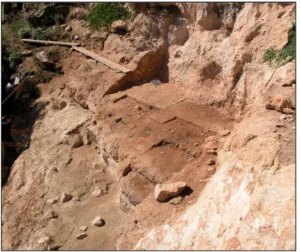
The overhang of the shelter had collapsed, so today it presents a little coverage capacity. By the way the deposit spreads for approximately 60 m2 and the entire stratigraphic sequence reaches, in its central part, a depth of 6 m as it was evidenced by the trial trench opened along one of the shelter rock wall58.
The stratigraphic sequence is made up by 27 sub-horizontal layers, whose extension downwards gradually increases cause in the shelter the hill erosion has damaged deposit especially on the upper layer59.
Fig. 5 Stratigraphic profile of the site (Profile P. Boscato)
58 BOSCATO & CREZZINI 2012 59
BOSCATO ET AL..2000-01.
21 2.2 HISTORY OF THE EXCAVATION
The excavations have taken place almost every September since 1998 until today. Interventions can be briefly summarized as follows:
1998: excavation of the trench for the identification of the stratigraphic sequence60.
1999: removing reworked sediments over the area and clarification of the stratigraphic sequence61.
2000:removing of US 1 ,2 ,29 that consist in residual plaque placed against the wall so as to open a surface of 2m2.62
2001:removing of US 1,2.30,31 to discover an area that measure almost of 7m 2in sectors C
-G\9-12 and excavation US 3 in the sectors E-F63.
2002: excavation US 2 ,29 ,30,31 in the sectors G10-11 expose US 3 to an area of almost 9 m2 64.
2003: excavation US 3-4 65.
2004: excavation US. 4 for an area of about 10 m2 and expose US 5 and US 7in an area of
about 3 m266.
2005: final removal of the US 4 and investigation of US 5 and 767.
2006: continuation of the excavation of US 5 and 7, excavation US 6 and beginning of the excavation of US 8, which results particularly rich of fire-pits 68.
2007: excavation of the US 9, removal of the series of fire-pits on the top of US 9 and identification of new fire-pits69.
2009: excavation of the US 9 (for an area of about 10 m2) and of the US 43. Beginning of
excavation of US 11 and identification and excavation of another complex fire-pits70.
2010: continuation of the excavation of US 11 (for an area of about 10 m2) and related fire -pits71.
60 ID.
61 ID. 62 ID.
63 BOSCATO ET AL.2002. 64
BOSCATO ET AL.2003.
65 BOSCATO & RONCHITELLI 2005. 66 ID.
67
BOSCATO & RONCHITELLI 2006. 68BOSCATO & RONCHITELLI 2007. 69 BOSCATO & RONCHITELLI 2009. 70 BOSCATO & RONCHITELLI 2010. 71
22
2011: continuation of the excavation of US 11 and the beginning and continuation of the excavation of US 13 and associated fire-pits (in an area of about 12 m2), with savings of a band (0.25m to 0.5 m wide) along the wall of rock shelter72.
2012: excavation of the US 14-Tephra in the square D/G-13/16 (for an area of about 11 m2) and expose in the same sectors, of the US 15 that is a paleosoil sealed on the top by the tephra73.
2.3 STRATIGRAPHY AND CHRONOLOGY
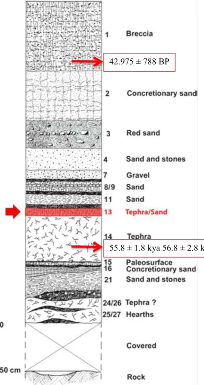
Excavations interest about half of the area and they reached the top of US 14 (in the deepest area in the trench) in the 2012 season. The topographic profile of the deposit (limited to the excavated portion), as evidenced by the four sections (spaced apart by one meter), appears articulated in a concave contour, which defines two sectors with two different angles of slope. The first sector (corresponding to the upper part of the deposit) stood at an angle of approximately 40 °, while the second stands at an angle of slightly more than 23 °. The stratigraphic deposit consists in a rich sequence of sub-horizontal layers, exposed along the surface of erosion of the slope74. The general sequence up to the US 13 consists of fifteen levels, we present the US of this level below.
US 1: Breccia made of tenacious limestone cement with fragments of sandy matrix calcarenite, yellowish light gray (10 YR 6/4- Munsell), the
72 BOSCATO & RONCHITELLI 2011, FASTIONLINE 2011. 73 BOSCATO & RONCHITELLI 2008, FASTIONLINE 2012. 74
SPAGNOLO 2011-12.
42.975 ± 788 BP
55.8 ± 1.8 kya 56.8 ± 2.8 kya
23
average thickness of about 70 cm) The layer is little inclined with immersion to N / NE (147 ° N 12 ° N / NE). For the base of this layer is available a calibrated C14 data of 42.975 ± 788 BP (AMS, beta 181165; not cal. 38.5 ± 0.9 ky BP)75. This dating has been done on a fragment of burned bone. This dating is near the end of the last anthropic occupation of the site, which coincides with the final presence of Neandertal in Europe and does not differ much from the arrival of the first Modern human in Europe (moreover noted in Salento)76. US 2: Breccia similar to the previous one but more sandy, dark yellowish brown (10 YR 3/6
-Munsell), the thickness between 2 and 43 cm. The layer is slightly tilted with immersion in E / SE (170 ° N 27 ° E / SE).77
US 29: friable sand with gravel component, dark yellowish brown (10 YR 3/4 - Munsell), with a thickness between 1 and 9 cm. The layer is sub-horizontal with a slight dip to E / NE (160 ° N 7 ° E / NE).78
US 30: friable sand with gravel component, dark yellowish brown (10 YR 3/4 - Munsell), with a thickness between 1 and 16 cm. The layer is sub-horizontal with a slight dip E (178 ° N 7 ° E)79.
US 31: friable sand with gravel component, brown (7.5 YR 4/4 - Munsell), with a thickness comprised between 2 and 20 cm. This layer present some dark patches of ash. The layer is sub-horizontal with a slight dip to E / NE (163 ° N 8 ° E / NE) 80.
US 3: compact sand, dark brown (7.5 YR 4/6 - Munsell) tending to yellowish red (5 YR 4/6 - Munsell), with big calcarenitic fragments (almost 10 cm), the layer shows a thickness between 2 and 33 cm. The layer is sub-horizontal with a slight dip to E / NE (168 ° N 8 ° E / NE)81.
US 4: compact sand probably resulting from the disintegration of the calcarenite on which the rockshelter is open, dark yellowish brown (10 YR 4/4 - Munsell), mixed with small pebbles, of a thickness of between approximately 2 and 35 cm. The layer is sub-horizontal with a slight dip NE (124 ° N 4 ° E)82.
75
BOSCATO & CREZZINI 2012.
76 BENAZZI ET AL. 2011,SPAGNOLO 2011-12. 77 BOSCATO ET AL 2000-01, SPAGNOLO 2011-12. 78
BOSCATO ET AL.2002, SPAGNOLO 2011-12.
79 BOSCATO ET AL.2002; BOSCATO ET AL.2003; SPAGNOLO 2011-12. 80 ID.
81 BOSCATO ET AL.2003; SPAGNOLO 2011-12. 82
24
US 7: compact sand with gravel component, dark yellowish brown (10 YR 4/4 - Munsell) with a thickness of between 2 and 17 cm. The sediment is slightly concretions. The layer is sub-horizontal with a slight dip in N / NE (110 ° N 5 ° N / NE)83.
US 8: compact sand with gravel component, dark brown (7.5 YR 4/6 - Munsell) with a thickness between 1 and 8 cm. The layer is sub-horizontal with a slight dip in N / NW (78 ° N 6 ° N / NW) 84.
US 9: compact sand, dark brown not homogeneous (7.5 YR 4/6 - Munsell), with a thickness between 2 and 16 cm. The layer is sub-horizontal with a slight dip in N / NW (71 ° N 7 ° N / NW) 85.
US 11: compact sand, dark yellowish brown (10 YR 3/4 - Munsell) with a thickness of between about 1 and 18 cm, dug in 3 artificial cuts. The layer is sub-horizontal with a slight dip in N / NW (74 ° N 8 ° N / NW)86.
US 13: sandy compact deposit mixed with pyroclastic sediment, yellowish brown (10 YR 5/6 - Munsell), with thickness between 3 and 11 cm (average of 5 cm in the non-eroded area), dug in 2 artificial cuts. The layer is sub-horizontal with a slight dip in N / NW (68 ° N 6 ° N / NW). The cut 1 consists in a transition between tephra below and some elements of the US above (US 11). The passage between the US11 and US13 is really clear: the tephra is composed of light yellow fine sand in clear contrast with the brownish coarser sand of the US 11. Above the ? of US 13 is exposed a series of structured fire-pits. Fragments of limestone concretions are present in D11/I-II and D12 / I. An area of rather tenacious concretion is present on the strip along the wall and some bands of advancement of the flow of carbonate water. US 13 fills the strong irregularity of US 14 (usually small holes apparently related to erosion or roots action). Within these depressions US 13 is clear brown and almost sterile. Also the switch between US 13 and proper tephra (US 14) is clear and easily distinguishable.
US 14: Pyroclastic deposit, light yellowish brown (2.5Y 6/4 - Munsell), with thickness of about 60 cm. The layer is sub-horizontal with a slight dip in N (90 ° N 5 ° N). The prof. Roberto Sulplizio (University of Bari, Department of Earth Sciences and geo -environmental) attributed the level of tephra to Tufo Verde di Monte Epomeo (Ischia)87,
83
BOSCATO & RONCHITELLI 2005; BOSCATO&RONCHITELLI 2006; SPAGNOLO 2011-12 84 BOSCATO & RONCHITELLI 2007; SPAGNOLO 2011-12.
85 BOSCATO & RONCHITELLI 2009; BOSCATO & RONCHITELLI 2010; SPAGNOLO 2011-12. 86 BOSCATO & RONCHITELLI 2010; BOSCATO & RONCHITELLI 2011; SPAGNOLO 2011-12. 87
25
identify in the stratigraphic series of Monticchio88, dated with the technique of K / Ar between 55.8 ± 1.8 kya (Gillot 1982) and 56.8 ± 2.8 kya (Vezzoli 1988)89.
The absolute dates available for the top and the base of the stratigraphic sequence described here (half of the all sequence in the rockselter) give a duration of 10.000 -15.000 years to this part of the stratigraphic sequence that comprehended approximately between 40-55 ka correspondent to the first half of OIS 3. This is an important information because it allows a direct correlation between the deposit of the Oscurusciuto and the paleo-environmental events of the region Puglia during the last period of occupation of Neandertal population in the Peninsula.
2.4 WATER ACTION ON THE ROCKSHELTER
The action of water can erode the deposit but it can it can also carry material solved in it. The US 13 does not present a uniform consistency throughout its surface. Some areas, in fact, are affected by a strong concretioning carbonate, which makes them difficult to dig. The distribution of the concretions is not random: water action is, in fact, directly linked to the level of resistance that the various types of rocks oppose the action of water.
In the deposit the concretion is particularly strong against the wall, while the rest of the layer appears in the form of "sagging" localized. This aspect is related to the chemical nature of the rock in which the rockshelter opens . The entire stratigraphic sequence, in fact, rests on a carbonate rock (Calcareniti of Gravina), that is soluble in water. The meteoric waters, dissolving these rocks
88 ALLEN ET AL. 2000. 89
26
upstream, would transporting solutes carbonates, due to gravity, right into the layers of the shelter, where these carbonates deposited and cemented with the matrix 90.
2.5 METHOD OF EXCAVATION AND DOCUMENTATION
The excavation area was divided into squares of 1m of size, which were further divided into four quadrants of 50 cm of size. The layer was removed with great accuracy working with chisels and trowels, and the sediment obtained has been dry- sieved and water- sieved with the aid of fine mesh sieves (1mm).
The material, divided by quadrants of origin, was then dried in the sun, then it was assessed and divided into general categories of artifact, that is to say lithic material, macrofauna, microfauna, malacofauna and coals.
The Cartesian coordinates of all the finds were collected and so it was possible to positionate all the findings of a size larger than 200mm2. Once divided, they were packaged and cataloged.
The documentation of the excavation was carried out by filling out fixed US cards, accompanied, if necessary, by the collection of sediment samples. As regards the graphic documentation in particular we recurred to photos, plans and sketches.
The treatment of the archaeological material from US 13 has already been the subject of a study led by Vincenzo Spagnolo at the section di Preistoria e Antropologia at the University of Siena. In his research he has conducted a spatial analysis of materials with the help of a GIS platform. Due to these operations all the material has been washed thoroughly and signed.
Having thus concluded the preparations of the materials, it was possible to proceed to the analysis itself.
2.7 US 13 AND PALEOENVIRONMENT
The US 13 consists in the sedimentary interface between the US 11, sandy layer above, and the US 14, the proper tephra deposit. This layer is interpreted as a new occupation of the shelter, which occurred during the final phase of the deposition of the volcanic ashes.
90
27
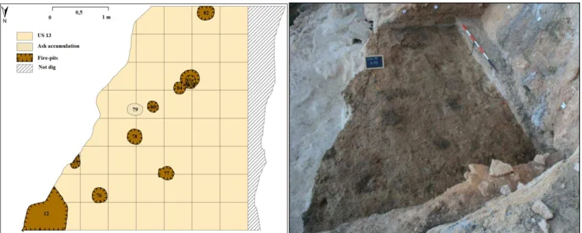
Above the of US 13 is exposed a darker accumulation of ash named US 79 and a series of structured fire-pits made in prepared dimple (US 12,74, 75, 76, 77, 78, 80, 83A, 83B, 84, 82). Those fire-pits are divided on the basis of their dimension in two main categories: little ones, with a diameter of almost 20 cm; and middle ones with a diameter of 50 cm. All the deposit shows a great grade of conservation91.
The distribution of the fire-pits in the US 13 seems to form a cord that delimits an area on the corner of the shelter, this same distribution of the hearths was found in the upper US 9 and
91
BOSCATO & RONCHITELLI 2008; SPAGNOLO 2011-12.
US 80: Fire-pit structured in dimple of sub-circular shape (20x19). The dark fill is homogeneous with sporadic materials. On w the edges of the dimple are almost vertical.
US 82: Fire- pit divided into sub-circular dimple (24x32). Above, in the same area of the fire, there were several dark spots not attributable to individual structures
Fig. 8 Plan and photo of US 13 (Plan modified from SPAGNOLO 2013, photo BOSCATO)
28
US11. In the US 7on the other hand is no longer present the cord of small round fire and, on the contrary, we note the presence of a large hearth placed in a depression of about 2m radius in the northern corner of the shelter.
This double arrangement of the combustion area seems to indicate two different phases of management of the space inhabited.
While in the level US 7 the large hearth at an angle against the wall only allows the use of outer space in the shelter.
In level US 9, US 11 and US. 13 (the subject of this dissertation) the number of fires, located approximately 2 m from the walls of the shelter, at least partially lit at the same time could constitute a small protected area between the rock and fire.
These morphologies of fireplaces as well as a different management of the space may be linked to different modes of use: studies of micromorphology to solve this issue are still in progress at the University of Boston.
The archeological material found in this layer are lithic items and fauna remains. Their majority is concentrated in the outer band, next to the edge of erosion, apparently in small clumps, especially in the lower part of the US92 (For specific information, refer to chapter 4).
The attestations of the presence of fauna in this layer are poor, moreover the bones we dispose of are extremely fragmented, but, in spite of this situation, some of the bones were attributable to Bos primigenius93.This data is in good accordance with the presences of fauna in the upper level where we also have the predominance of Bos primigenius94
The faunal association dominated by this taxa and the absence of forest species indicate that the environment was a grassland contains trees with limited coverage areas in wooded95.
The dating also raise the level of US 13 between 40-55 ka correspondent to the first half of OIS 3 that is a moment climate characterized by fluctuations rather cold and dry.
It is also possible to get information about the reconstruction of the environment thanks to the sedimentary record of Lago Grande di Monticchio
This is a lake situated in the volcanic crater on the western flank of Monte Vulture in Basilicata, southern Italy.
The site provide a sedimentary record with no major hiatuses since the formation of the lake that can be correlated to a calendar year chronology. An age of 101,530 calendar years BP is given for the lowermost sediments sampled, furthermore the sedimentary sequence includes numerous tephra
92 SPAGNOLO 2011-12
93 Personal comunication of Prof. Boscato. 94 BOSCATO & CREZZINI 2009
95
29
layers, the chemical composition of one of them, the Marker Tephra 9 (MT-9), indicates an origin in one of the Ischia volcanoes, and for its stratigraphic position was suggests its correlation with the eruption of Tufo Verde di Monte Epomeo96. This is exactly the same sediment on which lay the layer 13 of the Oscurusciuto.
The palinological record of Lago di Monticchio for the period between 40.000 and 55.000 BP indicate the following biome and climate:
40.000 BP: Betula-Quercus woodland with Ulmus and Fagus within predominantly steppe vegetation; that indicate a climate warmer and less dry.
42.300 BP Artemisia-Gramineae steppe with rare Betula, Fagus and Abies. Increase in Juniperus at end of zone; that indicate a cool dryish climate, becoming cold.
50.000 BP Betula-Quercus woodland at first, replaced by Quercus-Abies woodland. Betula and Pinus continuously present; that indicate a climate less warm and moist becoming cooler
53.800 BP Artemisia-Gramineae steppe with Chenopodiaceae and Caryophyllaceae; all trees very rare; regional Pinus; that indicate a cold and dry climate.
56.200 BP Steppe with occasional Quercus and Fagus woods, plus Pinus and Juniperus; that indicate a climate less cold and less dry97.
96 NARCISI 1996.
97
ALLEN ET AL. 2000.
30 3. LITHIC INDUSTRIES OF THE US 13
3.1THE LITHIC MATERIAL
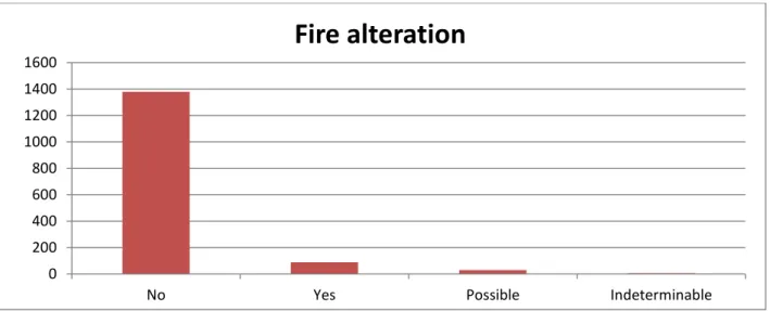
7505 lithic artifacts were found in the layer (US13 and fire-pits). Their physical condition is very good and their edges are fresh. Due to the presence of fire-pits some artifacts present signs of fire. The surfaces of some artifacts show different patina because of chemical alteration.
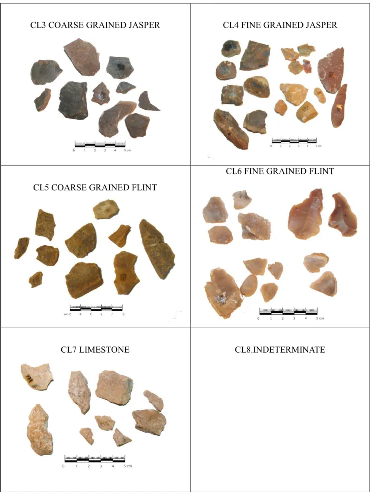
The dominant raw material, as in the upper layer, are jasper and flint found in form of rolled and oblong pebbles. Probably it was collected locally from the gravel fluvial and sea terraces that still today are visible near the site.98
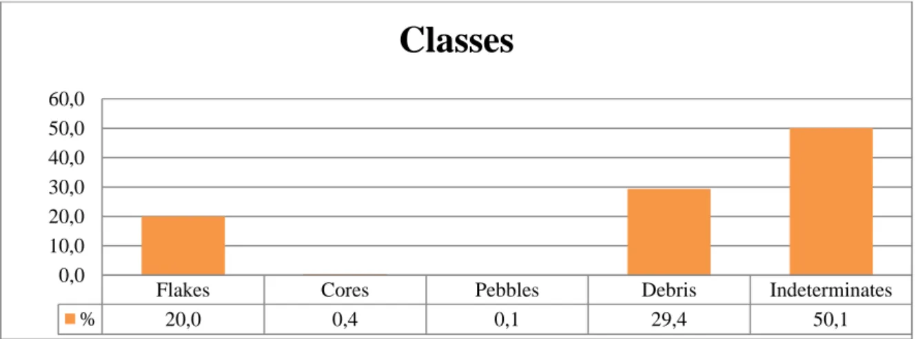
The quantitative composition of the lithic industry is show in the table.
Classes
Quantity (%)
Flakes 1503 20,0
Cores 33 0,4
Pebbles 8 0,1
Debris 2203 29,4
Indeterminates 3758 50,1
Total 7505 100,0
Table 2 Composition of the lithic industries
Almost 80% of the collection is made by indeterminate items and debris, the 20% is made by flakes finally pebbles and core are few.
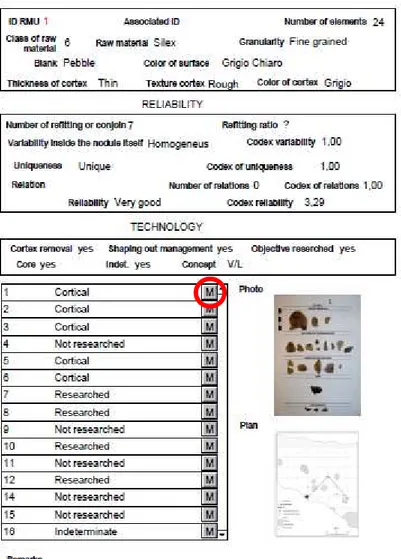
Since the composition of the industry is such, we thought of what could be the best approach to properly study it: since one of the essential methodology to understand a lithic industry is the technological approach, we came to the decision to complement it by an innovative approach: the minimum analytical analysis nodules (MAN)99 or Raw material units (RMU)100, also knowed as Unità di Materia Prima Litica (UNPL)101. This approach allows us to study the individual blocks of raw material introduced to the site (n.b. by “block” we means here the single pebble). Through the analysis of the blocks it is therefore possible to get to the identification of individual technical episodes developed within the site.
98 VILLA ET AL. 2008; BOSCATO ET AL. 2011; SPAGNOLO 2011-12. 99DOUGLASS 2010; HALL 2004; LARSON 2012; ODDEL 2004.
100 ROEBROOKS 1988; UTHMEIER 2006; ROEBROOKS 1997; VAQUERO 2008; CARBONELL 2012; ROMAGNOLI 2012. 101
31
To develop the potential that this approach can offer we chose the level US 13 of the Oscurusciuto rock shelter because the amount of artifacts is not elevated there. Another reason for this choice was the accuracy of the documentation, especially the one related to the spatial distribution, and the particular features of the materials because, in fact, if observed from a macroscopic point of view, the artifact appears very different in granularity, color, aspect and nature of the raw materials.
Furthermore, the study is based on the collaboration with the student Vincenzo Spagnolo who, in his master's thesis, has developed a GIS platform to apply to the site, in order to have a better understanding of the management of the space, not only on the macro level but also at a more particular level. To state it precisely, this peculiar platform allows a deep understanding of the spatial distribution of the pieces that are considered part of each block (For specific information, refer to chapter 4).
For the analysis of the lithic, the use of the classical technological analysis complement applied to every single block turned out to be a good chance to integrate the results of both studies in order to get a wider range of information.
3.2 OBJECTIVES OF THE STUDY
The goals we want to reach are different but complementary; our three main aims are: I. TECHNOLOGICAL\TECHNO-ECONOMICAL GOAL
We mean to detect the technological Behavior expressed by Human groups living in this site. We intend to reach this purpose by: the description of the economic behavior as far as regards the exploitation of raw material and the production of lithic tools (procurement of raw material); the identification of the Chaine operatoire, which means to check the different stages of the lithic production that are cortex removal, management, production, transformation by retouch, utilization and abandon; the definition of concepts, methods, dynamics and objectives of débitage.
II. METODOLOGICAL GOAL
32
By doing so, we have two levels of “magnification” on the site: a general data obtained from technological analysis and a more punctual one obtained by the analysis of the elements that made up a single unit (RMU).
III. CHRONOCULTURAL GOAL
Once we have the technic tools suitable for studying the technological behavior of humans in that site, we intend to compare these data with those coming from the other contemporaneous site in the region of Puglia. We consider that the period between 40.000 and 55.000 BP is particularly interesting especially because of the dynamic of occupation, and management of the area by the human population. The reason lies in the fact that during this period the last occupation of Neandertal and the first settlement of Modern humans in Europe have taken place.
3.2 THEORY AND METHODOLOGY
In this work, the methodological aspect plays an important role because we will proceed by testing the opportunity to cross technological analysis and analysis of the blocks.
The aim of the study is to integrate results about the general technologic composition of the lithic industry and a more specific analysis of each block, in order to design new hypothesis on the use and management of the site.
Technological analysis
Basic references in this research have been the French school works dated 70th and 80th and
the text-book of Tixier, Inizan , Roche, Boeda, Geneste, Revillion, Tuffreau, Forestier102.
The understanding of cultural technology, inside the ethnologic study investigate the technical system103 “Technology” means the conceptual approach to the culture of material. The rational study of technics and of manufactures of a human group together with all the cultural behavior is considered the first fundamental step for each scientific investigation 104.
102 INIZAN ET AL. 1999; BOËDA 1990; 1993; 1994; FORESTIER 1993; GENESTE 1991; REVILLION & TUFFREAU 1994. 103 Cit. In GENESTE 1991.
104
33
The basic concept in every technologic study is therefore the operative chain introduced by Leroi-Gourhan105. The expression “operative chain” actually indicate the operational sequence of actions to handmade the object.
So, the aim of lithic technology is to put the single artefact into the chaine operatoire, which is the sequence of the technical operations, actions and choices made by the knapper, to practically go back to the real purpose that probably the original craftsman had pursued. All that is carefully made in order to comprehend what was the human techno-economical behaviour in the past and how it was influenced by the physical singularities of the raw material which, as already stated, was often conditioning the technical choices of men.
This process works on thanks to the reconstruction of what was the life of each single handmade object starting from simple raw material then going on to the final object and eventually reaching the phase of its discard. The process could be divided in phases: the first is the acquisition of the raw material, the second is the initialization and the cortex removal; the third is the shaping out of the core and management of the convexities; the forth the production; the fifth, the eventual transformation by retouch; then the use and at the end the abandon.
Another level of analysis interests the reconstruction of the technical schemes and the conceptual systems; this happens through the recognition of knapping methods and techniques.
The technological study puts in evidence the dynamic point of view of the hand-made object, showing each relationship between techniques, physical, environmental, socio-economic aspects and the choice to create the hand-made itself.
Refitting and Minimum analytical nodules
By Minimum analytical nodules we are able to study the single block of raw material exploited in the site (as block we consider each pebble). The analysis of the blocks makes possible the identification of technical evolution’s phases and understand special management and dynamics inter and intra site.
In literature this approach is called by different acronyms:
UMPL (Unità di Materia Prima Litica), use in Italy (ARZARELLO ET AL. 2011, Manuale di tecnologia litica preistorica.) Concetti, metodi e tecniche.
105