AGRO-CLIMATIC ZONING TO BANANA-GROWING
IN THE MESOREGION OF VALE DO RIO DOCE
1GEOVÁLIA OLIVEIRA COELHO2, LUIZ ANTÔNIO DOS SANTOS DIAS3,
FERNANDO LUIZ FINGER4
ABSTRACT - This study aims at identifying by zoning the mesoregion of Vale do Rio Doce edaphoclimatic aptitude for the commercial production of banana. The factors used in the agro-climatic zoning were temperature, altitude, rainfall, water deficit and soil type. Information on the thermal conditions was acquired from the INMET and also using estimates from a mathematical model. Altimetry data were acquired using digital elevation model generated from ASTER images. Rainfall data were collected from literature and from the ANA. To obtain the data of water deficit a standard water balance was calculated. Soil information was provided by Geominas Program. According to the results it was evident that banana can be grown with
the use of irrigation in 28.7% of the zoned area (about 11,000 km2) emphasizing Guanhães, Mantena and
Aimorés microregion. It was clear that 71.3% from the mesoregion is unsuitable to produce bananas because of the altitude and soil type. Moreover it was also clear that the mesoregion of Vale do Rio Doce has no preferential and suitable areas for the cultivation of unirrigated banana.
Index terms: Musa spp., zoning, mesoregion of Vale do Rio Doce.
ZONEAMENTO AGROCLIMÁTICO PARA A CULTURA DA BANANA
NA MESORREGIÃO VALE DO RIO DOCE – MG
RESUMO - O objetivo desta pesquisa foi identificar, por meio de zoneamento, a aptidão edafoclimática da
mesorregião do Vale do Rio Doce para a produção comercial de banana. Os fatores utilizados no zoneamento agroclimático foram temperatura, altitude, precipitação, deficiência hídrica e tipo de solo. As informações sobre as condições térmicas foram obtidas do Instituto Nacional de Meteorologia e por meio de estimativas de modelo matemático. Os dados altimétricos foram obtidos por meio do modelo digital de elevação, gerado a partir de imagens ASTER da mesorregião. Os dados de precipitação foram coletados da literatura e da Agência Nacional de Águas. Para a obtenção dos dados de deficiência hídrica, foi calculado o balanço hídrico normal. As informações de solo foram adquiridas do Programa GeoMinas. A pesquisa evidenciou que a bananeira pode ser cultivada com o uso de irrigação, em 28,7% da área zoneada (1,1 milhão de hectares), com destaque para as microrregiões de Guanhães, Mantena e Aimorés. Por outro lado, 71,3% da mesorregião são inaptas para o cultivo da banana, em função da altitude e do tipo de solo. A mesorregião do Vale do Rio Doce não possui áreas preferenciais e/ou aptas ao cultivo de sequeiro da banana.
Termos para indexação: Musa spp., zoneamento, Vale do Rio Doce.
1(Paper 050-15). Received January 22, 2015. Accepted July 06, 2015.
2DSc in Phytotechnology, Professor at IFMG, São João Evangelista Campus, Av. 1º de Junho, 1043, 39705-000, São João Evangelista
- MG. E-mail: geovalia.santos@ifmg.edu.br
3DSc in Genetics and Improvement, Professor at the Federal University of Viçosa, Department of Plant Science, Av. P H Rolfs, s / n,
36570-900, Viçosa - MG. E-mail: lasdias@ufv.br
4PhD in Horticulture, Professor at the Federal University of Viçosa, Department of Plant Science, Av. P H Rolfs, s / n, 36570-900,
Viçosa - MG. E-mail: ffinger@ufv.br
2 G. O. COELHO et al.
Rev. Bras. Frutic., v. 38, n. 4: (e-908) DOI 10.1590/0100-29452016908 Jul/Aug 2016 Jaboticabal - SP
INTRODUCTION
Fruit growing is an activity that has contributed significantly to national economic development, due to its capacity of employment and income generation in the agribusiness chain. This activity generates about five million jobs and accounts for 25% of national agricultural production. Brazil is the world’s third largest fruit producer, with 43.6 million tons harvested in 2.2 million hectares. 53% of this production is destined for the fresh fruit market and the remaining 47% for the processed fruit. Brazilian fruit growing is practiced with tropical, subtropical and temperate fruits due to the territorial extension of the country, geographical position, different soil types and different climatic conditions. There are 500 native edible fruit species, 220 of them found in the Amazon (CNA, 2013; IBRAF, 2013).
A m o n g t h e f r u i t s p r o d u c e d a n d commercialized in the country, banana (Musa spp.) occupies a prominent position. Brazil was the sixth largest fruit producer in 2012 (SALOMÃO; SIQUEIRA, 2015). Minas Gerais accounts for 8.9% of national production, represented by 654,000 tons harvested in 41.400 hectares (IBGE, 2014). The consumer market is the applicant of the fruit to the growing urban populations. Its consumption fresh and as raw material for products such as sweets, flour, dry banana and handcraft has increased considerably in the recent years. According to FAO, Food and Agriculture Organization of the United Nations, Brazilians reached an average consumption per capita year of 29.1 kg of banana, two and a half times the world average consumption (FAO, 2014). This high consumption is due to the knowledge of the nutritional value of the fruit, associated to the excellent flavor and low market price.
The consumer market for bananas responds positively to the introduction of initiatives of new products and new producing regions. These new regions, when present edaphoclimatic conditions satisfying the demands of the culture, contribute to increase productivity and banana quality. In this context, the mesoregion of Vale do Rio Doce has characteristics that qualify it for the cultivation of bananas. It is the sixth largest mesoregion of the
state in area, with 41,809.87 km2, and has fertile
soils and high temperatures suitable for tropical fruit cultivation and long-cycle plants such as banana. In addition, the Vale do Rio Doce present to be economically stagnated requiring incentives for the establishment of banana plantations in order to improve life quality of the population and boost regional development. The knowledge of
edaphoclimatic conditions of Vale do Rio Doce is important for evaluating the eventual deployment and/or establishment of commercial banana crop. Such knowledge is possible by agroclimatic zoning.
If understood the concept of Wollman and Galvani (2013), the zoning is the technique of delimitation of aptitude of growing regions as the climate and soil factors in macroclimatic and regional scales. It is used to identify and delimitate areas suitable for crops or subject to climate risks or fitodisease escape (PEREIRA et al. 2002; SENTELHAS; MONTEIRO, 2009). This is a technique of specialization of one or more combined information (SENTELHAS; MONTEIRO, 2009). In zoning, low resolution images and low quality interpolators can compromise the accuracy of the results. The interpolation of spatial data is a tool used to estimate any numeric variable in a point where its measurement was not performed. The geostatistical interpolation ponders the neighbors of the point to be estimated, in a not tendentious manner and with minimum variance to generate not biased maps (AKKALA et al., 2010). The quality of data spacialization provided by different interpolators has not received proper attention. The zoning is subject to incorporation of new study methodologies, larger number of variables, with more consistent data sets and use of interpolators that present more effective results (PEZZOPANE et al., 2012).
The Ministry of Agriculture, Livestock and Supply (MAPA) has made climate risk zoning for banana in the state of Minas Gerais, identifying municipalities able for cultivation and the planting periods with less climatic risk for the culture (BRASIL, 2010). Agroclimatic zoning have been prepared for fruit trees like avocado (ZARO et al., 2014) and macadamia nut (SCHNEIDER et al. 2012).
In this study we used the agro-climatic zoning for banana in the mesoregion of Vale do Rio Doce, in accordance with the methodology used by MAPA, adding altimetry data with the use of higher resolution satellite images.
MATERIAL AND METHODS
The mesoregion of Vale do Rio Doce has 140 municipalities allocated in the regions of Aimorés, Caratinga, Governador Valadares, Guanhães, Ipatinga, Mantena and Peçanha. It is located in the east of the state, between latitudes 18 ° 49 ‘12 “and 19 ° 03’ 00 ‘’ South and meridians 40 ° 49 ‘18” and 43 ° 33’ 36 “west of Greenwich and occupies an area of 41,791 km² (Figure 1).
it was considered the factors: rainfall, altitude, type and class of soil aptitude, temperature and water stress. For each factor has been established the parameter for the agricultural potential of the commercial banana, according to the criteria of culture requirements (ALVES et al., 1999; PEREIRA et al., 2007; RODRIGUES et al., 2008; COELHO et al. 2009) (Table 1):
a) average temperature higher than 18ºC and lower than 35ºC. The average of 28 ° C was considered preferential;
b) Average annual rainfall between 1,200 mm and 1,900 mm, being 1,900 mm preferential;
c) altitude from 0 to 300 m; d) water deficit lower than 100 mm; e) soils Groups I and II (Table 2).
In accordance with the above criteria were defined classes of aptitude for cultivation: preferential, suitable, suitable with irrigation, suitable with soil management, restricted by altitude, restricted by soil and inept (Tables 1 and 2). These classes allow you to identify suitable and inapt regions and with specific restrictions per variable evaluated.
Information on thermal conditions was obtained from the weather stations of the National Institute of Meteorology (INMET) located in the municipalities of Aimorés and Caratinga, with historical series of 22 years. However, considering the lack of information on meteorological data it was necessary to use models such as multiple regression equations (SEDIYAMA; MELO JUNIOR, 1998; MEDEIROS et al., 2005). For sites deprived of information, it was estimated the average annual temperature by means of regression equations, using the geographical coordinates and the altitude of the desired point. Thus it was also used data from meteorological stations of Hydrological Information System (HIDROWEB) of the National Water Agency (ANA) which, together with INMET stations totaled 102 points, complementing the spatial data.
The altimetry data were obtained from the digital elevation model (DEM) generated from ASTER images (Advanced Spaceborne Thermal Emission Reflection Radiometer) of October 2011, whose resolution has 30 m with vertical error of 7 to 14 m, using geographic projection system WGS84 (World Geodetic system) (ASTER, 2013).
Rainfall data of the mesoregion of Vale do Rio Doce were obtained from Guimarães et al. (2004) and ANA, resulting in 51 historical series. The data series of the ANA’s HIDROWEB system were selected on the basis of the collection duration (over 30 years), of its continuity and of the result of the consistency analysis.
To calculate the soil water deficit for banana plant it was used the normal hydric balance proposed by Thornthwaite and Mather (1955), from the spreadsheet developed by Rolim et al. (1998). It was taken as the amount of available water capacity in the soil (AWC) 100 mm, to be considered an average value for the culture according to Pereira et al. (2002). The normal water balance resulted from the joint analysis of temperature and average monthly precipitation of each station considered. The monthly average rainfall data were also obtained from the INMET weather stations and stations used to estimate the average monthly temperature.
Information on soil types have been acquired from the Integrated Use Program of Geoprocessing from the Government of Minas Gerais (Geominas). The Geographic Information System (GIS) used to generate the maps and perform their crossing was the ArcGIS version 10, with kriging interpolation methods for the generation of temperature maps and IDW (Inverse Distance Weighted) for the remaining maps. GIS and spatial interpolation techniques may be revised in Akkala et al. (201
RESULTS AND DISCUSSION
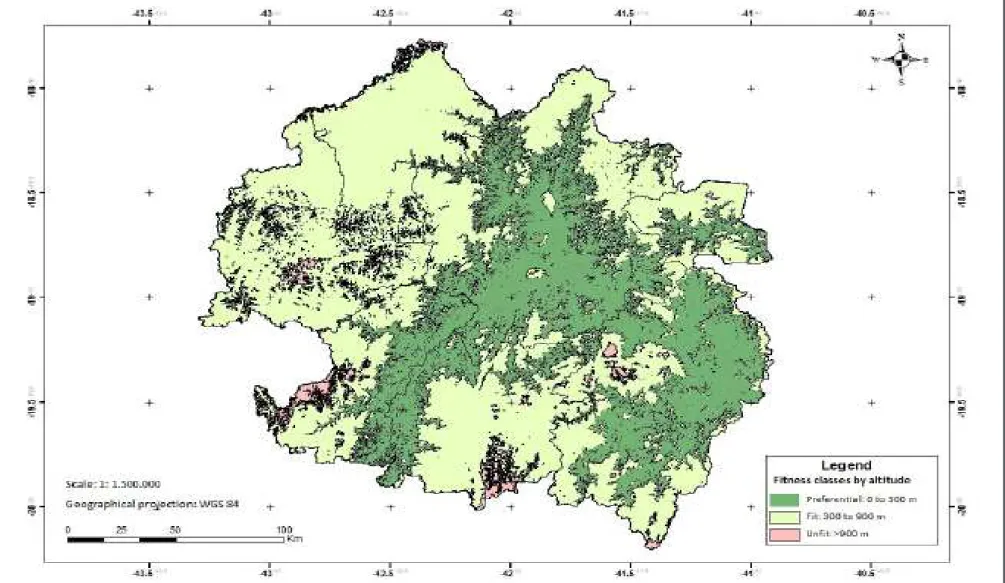
Considering the demands of the culture, the optimum temperature is 28 °C, with a minimum of 18 °C and maximum 35 °C. The banana tree should not be grown in areas with minimum temperature below 15 °C, as there is paralysis of their metabolic activity or above 35 °C when occurs the paralyzation of its development by dehydration of the leaves (ALVES et al., 1999; PEREIRA et al., 2007; RODRIGUES et al., 2008; COELHO et al. 2009). It is verified that the mesoregion of Vale do Rio Doce has, throughout its length, thermal conditions favorable to the cultivation of banana tree to present annual average temperatures within the required range (18 ° to 35 °C) for the good development of crops (Figure 2). Regarding the altitude, the range from 0 to 300 m was considered ideal for maximum productivity of banana tree (ALVES et al., 1999; PEREIRA et al., 2007; RODRIGUES et al., 2008; COELHO et al. 2009). It is known that in regions with altitude above 300 m the banana tree increases the duration of the production cycle. It is noted that more than 30% of the area of the mesoregion of Vale do Rio
Doce (12,832 km2) has altitudes within the ideal
range for growing (Figure 3). More than 65% of
the mesoregion area (27,532 km2) presents altitudes
4 G. O. COELHO et al.
Rev. Bras. Frutic., v. 38, n. 4: (e-908) DOI 10.1590/0100-29452016908 Jul/Aug 2016 Jaboticabal - SP
has altitude above 900 m, considered inappropriate (Table 1, Figure 3).
Regarding precipitation, the culture requires an average of 1,900 mm well distributed throughout the year. The consumption of water by the plant is high and constant, due to its morphology and hydration of the tissues. Annual rainfall below 1,200 mm restricts the cultivation of banana tree, as difficult or prevents the release of the inflorescence (ALVES et al., 1999; PEREIRA et al., 2007; RODRIGUES et al., 2008; COELHO et al. 2009). Thus, the mesoregion of Vale do Rio Doce have 34.3% of its
area (14,332.8 km2) suitable for cultivation having
average annual rainfall within the acceptable range (1,200-1,900 mm) for fruit production and 65.7 %
of its area (27,456.5 km2) unsuited to cultivation to
present annual average rainfall below 1,200 mm (Figure 4).
For water deficit, the annual limit considered acceptable for the banana cultivation is 100 mm. The deficit above 100 mm reduces plant productivity and the quality of its fruit (ALVES et al., 1999; PEREIRA et al., 2007; RODRIGUES et al., 2008; COELHO et al. 2009). Thus, it is observed that the mesoregion of Vale do Rio Doce has no favorable hydric conditions to be out of the acceptable limit of water deficiency (Figure 5). Throughout the extent of the mesoregion, water deficiency ranges from 116 mm (West and South) to 379 mm (Midwest and Northeast), annual amounts considered high for banana production in unirrigated conditions. In this sense, the banana plantation in the mesoregion of Vale do Rio Doce should only be recommended with supplementary irrigation.
Latosolic soils are suitable for banana production to be well-drained, deep (over 100 cm), medium texture to clayish, well-structured, permeable, fertile, neutral to slightly acidic pH, no risk of flooding and salinity free (SALOMÃO; SIQUEIRA, 2015). On the other hand, the shallow, rocky soils, as Neosoil and rocky outcrops are inadequate. The mesoregion of Vale do Rio Doce has more than 97% of its area suitable for banana cultivation by having Yellow, Red, Yellow and Red Latosols, Red Yellow Podzolic and Red Nitosol (Figure 6). Only 2.8% of the mesoregion are considered unsuitable for the banana crop, they are Neosoil or rocky outcrop, both inapt for culture.
From the suitability maps generated for each variable considered in the study, it was obtained agro-climatic zoning map for the banana in the mesoregion of Vale do Rio Doce (Figure 7). In it you can see that the mesoregion has 28.7% of the area suitable for the cultivation of bananas, since
if practiced with irrigation. This area of 11,000
km2 or 1.1 million ha is 27 times larger than the
current area planted with banana throughout the state of Minas Gerais. About 71.3% of the area is considered inappropriate to the cultivation of bananas. This is due to the altitude related to the type of mesoregion soil. For this last area, techniques are recommended as liming, fertilization and irrigation (more installments) for inapt soils (Neosoil). For restricted soils (Cambisoils), besides liming and fertilization is recommended the contour lines and rows of vegetation to allow banana production.
FIGURE 1
6 G. O. COELHO et al.
Rev. Bras. Frutic., v. 38, n. 4: (e-908) DOI 10.1590/0100-29452016908 Jul/Aug 2016 Jaboticabal - SP
TABLE 1 - Classes of aptitude for banana cultivation.
Classes of Aptitude
Annual average temperature
(ºC)
Annual water
deficiency (mm)
Annual average rainfall
(mm)
Altitude
(m) Soils
Preferential 28 <100 1900 0 - 300 I
Suitable 18 - 35 <100 1200 - 1900 0 - 900 II
Suitable with irrigation 18 - 35 >100 <1200 0 - 900 II
Suitable with soil management 18 - 35 <100 1200 - 1900 0 - 900 III
Restricted by altitude 18 - 35 <100 1200 - 1900 >900 II
Restricted by soil 18 - 35 <100 1200 - 1900 0 - 900 IV
Inept <15 e >35 >100 <1200 >900 IV
TABLE 2 – Classes of soil aptitude for banana cultivation.
Group Classes of
Aptitude Soils
I Preferred soils
Oxisol Eutroferric and Eutrophic Red Yellow Eutrophic Alfisoil, Luvisol Haplic, Cambisol, Chernossolos and Fluvic Neossols Eutrophic, non-salty, non-sodic and well drained.
II Suitable soils
Rhodic Eutrophic Red Yellow Eutrophic Alfisoil, Luvisol Haplic, Cambisol, Chernosol Argilúvico and Neosoil Fluvic Eutrophic, non-salty, non-sodic and well drained, Distroferric Red Latosol and dystrophic Red Yellow Latosol and Yellow, Red Nitosol Dystroferric Ultisol dystrophic and Yellow, Cambisol, Vertisol, Chernosol Argilúvico, Fluvic Neossols Dystrophic and or poorly drained, Gleysol, Organosols and Vertisols.
III Restricted soils
Quartzarenic Neosols Yellow Dystrophic Red Latosol (medium texture) and Iron Quadrangle, Luvisol and Argisol shallow, Chernosol Rêndzico, Luvisol Chromic shallow Orthic, shallow Cambisol, Neosoil, Spodosol and some Planosols with thick surface horizons (over 50 cm).
IV Inapt soil Litholic Neosols, Argissolos shallow and / or stony, Cambisol shallow and / or
stony, Luvisol Chromic Orthic shallow, Planosol and Gleysol.
Source: Adapted from EMBRAPA (2006).
FIGURE 2
–
Annual average temperature zones for the cultivation of banana in the mesoregion of
V
8
G. O. COELHO et al.
Rev
. Bras. Frutic., v
. 38, n. 4: (e-908) DOI
10.1590/0100-29452016908
Jul/Aug 2016 Jaboticabal - SP
FIGURE 4
–
Rainfall zones for the cultivation of banana in the mesoregion of
V
10
G. O. COELHO et al.
Rev
. Bras. Frutic., v
. 38, n. 4: (e-908) DOI
10.1590/0100-29452016908
Jul/Aug 2016 Jaboticabal - SP
FIGURE 6
Soil zones for banana cultivation in the mesoregion of
V
12 G. O. COELHO et al.
Rev. Bras. Frutic., v. 38, n. 4: (e-908) DOI 10.1590/0100-29452016908 Jul/Aug 2016 Jaboticabal - SP
FIGURE 7
-
Agro-climatic zoning for banana cultivation in the mesoregion of
V
CONCLUSION
The agro-climatic zoning for banana plants in the mesoregion of Vale do Rio Doce has allowed the conclusion that 28.7% of the area comprising the micro-regions of Guanhães, Mantena and Aimorés, has favorable conditions for irrigated cultivation.
ACKNOWLEDGEMENTS
We would like to thank the IFMG by the support given to the research, to CAPES for financial support, to the INMET and ANA for the availability of data on the Internet; and to the Federal University of Viçosa for the PhD opportunity.
REFERENCES
AKKALA, A.; DEVABHAKTUNI, V.; KUMAR, A. Interpolation techniques and associated software
for environmental data. Environmental Progress
& Sustainable Energy, Hoboken, v.29, n.2, p. 134-141, 2010.
ALVES, E.J.; OLIVEIRA, M.A.; DANTAS, J.L.L.; OLIVEIRA, S.L. Exigências climáticas. In: ALVES, E.J. (Org.). A cultura da banana: aspectos técnicos, socioeconômicos e agroindústrias. 2.ed. Brasília: Embrapa, 1999. v.1, cap.2, p.35-46.
ASTER - Advanced Spaceborne Thermal Emission Reflection Radiometer. Jet propulsion laboratory: California Institute of Technology, 2013. Disponível em: <http://asterweb.jpl.nasa.gov/index.asp>. Acesso em: 25 ago. 2013.
BRASIL. Ministério da Agricultura, Pecuária e Abastecimento. Secretaria de Política Agrícola/ Departamento de Gestão de Risco Rural. Portaria nº 268, de 18 de agosto de 2010. Brasília, 2010. 5p.
CNA – Confederação da Agricultura e Pecuária do Brasil. Balanço 2013 - perspectivas 2014. Brasília: CNA, 2013. 121p.
COELHO, E.F.; DONATO, S.L.R.; ANDRADE NETO, T.M. Banana. In: MONTEIRO, J.E.B.A.
(Org.). Agrometeorologia dos cultivos. O fator
meteorológico na produção agrícola. Brasília: INMET, 2009. p.321-322.
EMBRAPA - Centro Nacional de Pesquisa de Solos. Sistema brasileiro de classificação de solos. 2.ed. Rio de Janeiro: Embrapa Solos, 2006.
FAO - Food and Agriculture Organization of the
United Nations. FAOSTAT: statistics database.
Disponível em: <http://faostat3.fao.org/home/index. html#DOWNLOAD>. Acesso em: 28 jun. 2014.
GALÁN SAÚCO, V.; CABRERA CABRERA, J.; HERNÁNDEZ DELGADO, P.M.; RODRÍGUEZ PASTOR, M.C. Comparison of protected and open-air cultivation of Grande Naine and Dwarf Cavendish
bananas. Acta Horticulturae, The Hague, v.490,
p.247-259, 1998.
GUIMARÃES, D.P.; REIS, R.J. dos; SANS, L.M.A. Espacialização das chuvas em Minas Gerais. In: CONGRESSO BRASILEIRO DE
METEOROLOGIA, 13., 2004, Fortaleza. Anais...
IBGE – Instituto Brasileiro de Geografia. Canais: sidra. Disponível em: <http://www.sidra.ibge.gov. br/bda/tabela/listabl.asp?z=t&o=11&i=P&c=854>. Acesso em: 14 nov. 2014.
IBRAF - Instituto Brasileiro de Frutas. Panorama da
cadeia produtiva das frutas em 2012 e projeções
para 2013. Brasília: IBRAF, 2013. 127p.
JANICK, J.; AIT-OUBAHOU, A. Greenhouse
production of banana in Morocco. HortScience, Alexandria, v.24, p.22-27, 1989.
MEDEIROS, S.S.; CECÍLIO, R.A.; MELO JÚNIOR, J.C.F. de; SILVA JUNIOR, J.L.C. da. Estimativa e espacialização das temperaturas do ar mínimas, médias e máximas na região Nordeste do Brasil. Revista Brasileira de Engenharia Agrícola e
Ambiental, Campina Grande, v.9, n.2, p.247-255, 2005.
PEREIRA, A.R.; ANGELOCCI, L.R.; SENTELHAS,
P.C. Agrometeorologia: fundamentos e aplicações
práticas. Guaíba: Agropecuária, 2002. 478p.
PEREIRA, L.V.; FRÁGUAS, J.C.; SILVA, S.O.; CORDEIRO, Z.J.M.; SILVA, C.R. de R. Banana
(Musa spp.). In: PAULA JÚNIOR, T.J.; VENZON,
14 G. O. COELHO et al.
Rev. Bras. Frutic., v. 38, n. 4: (e-908) DOI 10.1590/0100-29452016908 Jul/Aug 2016 Jaboticabal - SP
PEZZOPANE, J.E.M.; CASTRO, F.S.; PEZZOPANE,
J.R.M.; CECÍLIO, R.A. Agrometeorologia:
aplicações para o Espírito Santo. Vitória: CAUFES, 2012. v.1, 174p.
RODRIGUES, M.G.V.; DIAS, M.S.C.; RUGGIERO, C . ; L I C H T E M B E R G , L . A . P l a n e j a m e n t o ,
implantação e manejo do bananal. Informe
Agropecuário, Belo Horizonte, v.29, n.245, p.14-24, 2008.
ROLIM, G.S.; SENTELHAS, P.C.; BARBIERI, V. Planilhas no ambiente EXCEL para os cálculos de balanços hídricos: normal, sequencial, de cultura e
de produtividade real e potencial. Revista Brasileira
de Agrometeorologia, Santa Maria, v.63, n.1, p.133-137, 1998.
SALOMÃO, L.C.C.; SIQUEIRA, D.L. de. Cultivo da bananeira. Viçosa: Editora UFV, 2015. 109p.
S C H N E I D E R , L . M . ; R O L I M , G . d e S . ; SOBIERAJSKI, G.da R.; PRELA-PANTANO, A.; PERDONÁ, M.J. Zoneamento agroclimático
de nogueira-macadâmia para o Brasil. Revista
Brasileira de Fruticultura, Jaboticabal, v.32, n.1, p.515-524, 2012.
SEDIYAMA, G.C.; MELO JÚNIOR, J.C.F. Modelos para estimativas das temperaturas normais mensais médias, máximas, mínimas e anual no Estado de
Minas Gerais. Revista Engenharia na Agricultura,
Viçosa, MG, v.6, n.1, p.57-61, 1998.
SENTELHAS, P.C.; MONTEIRO, J.E.B.A. Agrometeorologia dos cultivos. In: MONTEIRO, J.E.B.A. (Org.). Agrometeorologia dos cultivos. O fator meteorológico na produção agrícola. Brasília: INMET. 2009. p.1-12.
THORNTHWAITE, C.W.; MATHER, J.R. The
water balance. Centerton: Drexed Institute of Technology, 1995. 104p.
WOLLMANN, C.A.; GALVANI, E. Zoneamento agroclimático: linhas de pesquisa e caracterização
teórica-conceitual. Sociedade & Natureza,
Uberlândia, v.25, n.1, p.179-190, 2013.
ZARO, G.C.; RICCE, W. da S.; CARAMORI, P.H.; CARVALHO, S.L.C.; VICENTINI, M.E. Zoneamento agroclimático para a cultura do abacateiro no estado do Paraná. Revista Brasileira