An indoor navigation architecture using variable data
sources for blind and visually impaired persons
João Pedro Gomes, João Paulo Sousa School of Public Management, Communication and
Tourism
Polytechnic Institute of Bragança Mirandela, Portugal [email protected], [email protected]
Carlos R. Cunha, Elisabete Paulo Morais Applied Management Research Unit (UNIAG)
Polytechnic Institute of Bragança Mirandela, Portugal [email protected], [email protected]
Abstract — Contrary to outdoor positioning and navigation systems, there isn’t a counterpart global solution for indoor environments. Usually, the deployment of an indoor positioning system must be adapted case by case, according to the infrastructure and the objective of the localization. A particularly delicate case is related with persons who are blind or visually impaired. A robust and easy to use indoor navigation solution would be extremely useful, but this would also be particularly difficult to develop, given the special requirements of the system that would have to be more accurate and user friendly than a general solution. This paper presents a contribute to this subject, by proposing a hybrid indoor positioning system adaptable to the surrounding indoor structure, and dealing with different types of signals to increase accuracy. This would permit lower the deployment costs, since it could be done gradually, beginning with the likely existing Wi-Fi infrastructure to get a fairy accuracy up to a high accuracy using visual tags and NFC tags when necessary and possible.
Keywords - Indoor Positioning; Indoor Localization; Indoor Navigation; Blind and Visually Impaired; WiFi, Bluetooth, NFC.
I. INTRODUCTION
Effective navigation systems on outdoor environment are a reality nowadays for people all over the world. In fact, satellite navigation systems, such as GPS, are easily accessible and its accuracy is enough for many outdoor activities and navigation assistance. However, the propagation characteristics of the signals used in those systems makes it impracticable to be used on indoor environments, given the existing physical constraints. Furthermore, the accuracy needed for a large number of indoor applications are in scale of centimeters or decimeters, much more demanding than the allowed tolerance of the typical outdoor use cases, which may be of several meters.
Although solutions for indoor navigation exist, they’re still not delivery the same simplicity and quality of experience for the user, having limitations and being dependent of several requirements for its implementation and effectiveness.
Research on this subject has seen a remarkable growth lately. Just to get a sense of it, searching on academic journals papers on the subjects "indoor navigation", "indoor positioning" or "indoor localization" on an online research platform (EBSCOhost) shows almost the double of results published in the last three years, from 2015 to 2017, than
before that. However, there is still no universal solution for indoor positioning and navigation.
There are several different approaches and the more effective solutions for real-time indoor navigation systems are achieved combining several technologies and techniques [1]. Around us, there is an increasing number of devices that can help to get a better positioning, like wireless access points, Bluetooth beacons, radio-frequency (RF) tags and Internet of Things (IoT) devices. Smart environments will have more and more IoT devices that will help in positioning, [2] says that the essential requirements of constructing a smart building are knowing and determining the location. It’s expected, then, that positioning accuracy will increase with the rise of connected devices.
A. Blind and visual impaired positioning and navigation
There are an extensive number of use cases for positioning navigation systems (PNS). Some of them are related to blind and visually impaired (BVI) persons. For them, having a system that guides them through a new environment or a changed one, means more independence, more safety and more social equity.
A recent study [3] estimates that, in 2015, 441 million people were blind (36 million) or had visual impairment, and with a projected increase in prevalence for the next decades, as illustrated on Fig. 1.
Figure 1. Global trends and predictions of numbers of people who are blind,
These systems oriented to BVI persons are more challenging than the generality because the users will need more accurate positioning, clear navigation instructions as well as quicker processing times.
II. TECHNOLOGIES AND TECHNICS
There are several technologies and techniques used on positioning, and several ways of categorizing them, most of them reviewed recently [4]–[10].
A. Indoor Positioning techniques
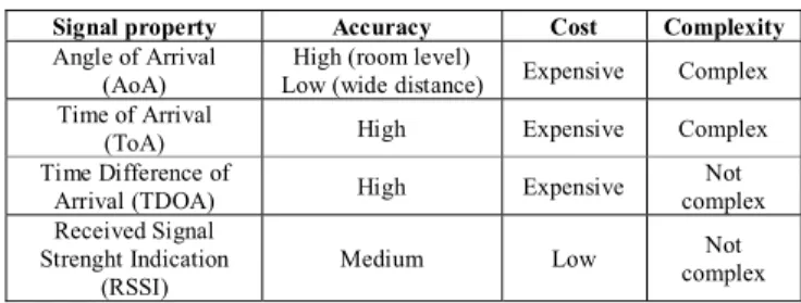
Table I shows the characteristics of several signal properties used as positioning techniques.
TABLE I. SIGNAL PROPERTIES CHARACTERISTICS (ADAPTED FROM [5])
Signal property Accuracy Cost Complexity Angle of Arrival
(AoA)
High (room level)
Low (wide distance) Expensive Complex Time of Arrival
(ToA) High Expensive Complex
Time Difference of
Arrival (TDOA) High Expensive
Not complex Received Signal
Strenght Indication (RSSI)
Medium Low Not
complex
Table II shows the characteristics of several algorithms used as positioning techniques. We can see that with the exception of room level triangulation, all the algorithms are expensive and complex.
TABLE II. SIGNAL PROPERTIES CHARACTERISTICS (ADAPTED FROM [5])
Positioning Algorithms Accuracy Cost Complexity Triangulation (room level) High Low Simple Triangulation (wide converage) Low Expensive Complex
Trilateration High Expensive Complex
Proximity High Expensive Complex
Scene Analisys/Fingerprinting Medium Expensive Complex
B. Some of the indoor positioning technologies
Indoor positioning technologies was classified by [11] as: x Infrared
x Ultrasound
o Active bat
o Cricket system
o Dolphin system
x Audible sound x Magnetic
x Optical and Vision
o Marker-based (e.g. QR code)
o Augmented Reality
x Radio Frequency
o Bluetooth-based
o UWB-based
o WSN-based
o WLAN-based
o RFID-based
o NFC-based
o Visible light
x Dead Reckoning
o Inertial sensors (e.g. accelerometer, gyroscope, magnetometer)
x Hybrid
Table III summarize the characteristics of this technologies. We can observe that few technologies supports high accuracy. Of those, NFC appears to be a good choice for use in a positioning system, having low cost, low complexity, being scalable and offering privacy. And it is supported natively by several smartphones models. Hybrid solutions can also be a good choice, since they can be used to enhance the accuracy of the ubiquitous Wi-Fi signals.
TABLE III. COMPARISON OF INDOOED POSITIONING TECHNOLOGIES (ADAPTED FROM [5])
Technology Accu-racy Cost
Comp-lexity
Scala-bility
Privacy/ Security
Real-time
Infrared 0 - + 0 - +
Magnetic + + + - - +
Optical/Vision - 0 0 - - +
Audible sound 0 0 0 0 - +
Active bat 0 0 0 0 - +
Cricket 0 - 0 0 + -
CricketNav 0 0 0 0 0 +
Dolphin 0 - 0 0 - +
Bluetooth - 0 0 0 0 +
UWB + 0 0 0 - +
WSN 0 0 0 0 - +
WLAN - 0 + 0 - +
RFID - 0 0 + - +
NFC + - - + + -
Visible light + 0 0 0 + +
DR / INS 0 - - 0 + +
Hybrid + 0 + + 0 +
Reference [4] compares several positioning technologies, and proposes a top three list of the most suitable positioning technology for each location based system (LBS) application segment. BVI users fit in the segments of Navigation, Location-Based Information Retrieval and Safety.
For the Indoor Navigation and Tracking
1. Bluetooth Low Energy (BLE)
2. Wireless Local Area Networks (WLAN)
3. (GNSS+INS)
For Location-Based Information Retrieval:
1. RFID
3. Wireless Local Area Networks (WLAN)
For Safety and Security:
1. (GNSS+INS)
2. Wireless Local Area Networks (WLAN)
3. The rest are almost equally unsuitable
For our study, we would discard GNSS technology, since it won’t be useful on indoor environments, although it would be important for a seamless transition between outdoor and indoor environments, which we are not exploring for now. The remaining most suitable technologies are BLE, Wi-Fi and RFID.
Table IV shows an overview of the accuracy and range of action of some of the technologies most suitable for our system.
TABLE IV. ACCURACY AND RANGE OF SOME RADIO SOURCES (ADAPTED FROM [12])
Technology Accuracy Range
Wi-Fi * *****
BLE ** ***
RFID **** ** NFC ***** *
C. Some solutions for the blind and visually impaired persons
The Blind MuseumTourer [13] is being developed for self-guided tours in museums, and the authors claim that it can be easily modified and customized to be applied in other use cases. Being the WLAN-based location determination considered a challenging project by the authors, the solution implemented uses Bluetooth low energy (BLE) beacons as proximity sensors to POIs position determination enhanced with inertial dead-reckoning calculations through step counting, heading and turn recognition. To help the BVI along the navigation there are also tactile linear routes on the floor. The requirement for the user is to use a smartphone, which must be steady in a belt around waist.
A visual landmark-based positioning system [14] was also presented. The system uses an unobtrusive self-constructed wearable device, worn on the chest, to collect images that are matched with a pre-constructed database with reference landmarks to determine the person’s location. The device also collects motion data that will be used to smooth the location results and to save computation time.
Also based on visual recognition, the Digital Sign System [15] uses digitally-encoded signs distributed throughout a building. This signs give information about is location and help users finding nearby point of interest and navigate to a desired destination. The user will need an infrared camera and a smartphone.
Another system [16] employs RFID technology to predict the positioning, using a tag reader to receive responses from long range active tags previously placed at strategic points. The data processing is made by a smartphone which will also be used to interact with the user giving audio feedback of his
voice requests. The tag information database for a particular building could be downloaded through an available connection as the user enters that building.
Wi-Fi signals are widely available in buildings, making it an obvious choice as a source signal for position determination. But their instability makes it necessary to combine it with other sources of information. A hybrid solution can be implemented based on the smartphone sensors, combining the absolute positioning, through Wi-Fi signals, and the relative positioning provided by the inertial sensors, like accelerometer and magnetic field sensor, allowing the estimation of speed and direction [17]. Other solutions added the barometer to estimate the floor level in the building [18].
III. PROPOSED ARCHITECTURE
As we presented there are, already, solutions to locate and guide a BVI in an indoor environment. Nonetheless, it’s not trivial to deploy a mass scale solution, particularly in what concerns with “the last step”, allowing an accurate positioning, so important in this user group.
In previous work, we presented an architecture [19], based on a smartphone, for indoor orientation of BVI persons combining radio signals (WiFi) and dead reckoning (inertial sensors) to enhance the accuracy. Later, we developed a prototype [20] based on that architecture to validate it. The prototype was tested on a supermarket, aiming to enable BVI persons to autonomously acquire consumer goods. The results show the importance of a positioning hybrid solution to get enough accuracy when using WiFi as radio signal. They also shows that, although the promising results guiding the person though the aisles, it was necessary a higher accuracy to allow a precise positioning near the desired product on the shelves to allow a BVI person to have an autonomous shopping experience. Regardless the possible better result that can be obtained with improved positioning algorithms, we believe that they would not be enough to guarantee the necessary accuracy.
So, giving continuity to that previous work, we present an improved architecture that can use other signal types besides WiFi to achieve the needed positioning accuracy.
A. Requirements
There is no ideal solution, but a good one should have some specific requirements. Different indoor LBS applications have different quality of service requirements and in [4] they are identified according to categories. An indoor LBS for BVI could be classified as belonging to three categories, Navigation and Tracking, Location-Based Information Retrieval and Safety and Security. Combining the quality of service requirements of them results in the following:
• Medium availability
• Response in real-time or few seconds
• Accuracy of very few meters or less
• Very high reliability and continuity
• Reasonable or cheap price
• Low power consumption
We had made slight changes on the original requirements, being more demanding on accuracy, since it’s for BVI, and not considering seamless availability (indoor and outdoor), since indoor environments is our current focus, although outdoor location services seems to be easier to implement and integrate on a global solution than the indoor part.
And, from the user perspective, we think that the best solution had to be minimally invasive, one that does not require the use of some attention-grabbing device. Also, it should be able to be used autonomously, so must be easy to use, and without prior authorization or the need to inform someone. Looking at those requirements, it seems obvious to consider the smartphone as a key component of the system. We opted for not considering, for now, using external readers/transceivers, such as ultra-wideband (UWB) [21].
B. Adaptive indoor positioning navigation system
With all this in mind, we propose an adaptive indoor PNS, with multisourced data, capable of dynamically provide different levels of accuracy depending on the available data sources. Its architecture is illustrated in Fig. 2.
Figure 2. An adaptive multisourced indoor positioning and navigating system
As noted in the Fig. 3, the data sources that a mid-range smartphone can deal with provides different location range and accuracy. In an ideal world we would always have maximum accuracy but, with the present available technology, this would imply high costs, since the best way to do it is by spreading beacons and tags all over the building.
Figure 3. Range/accuracy offered by different wireless signals (not in scale)
But, what if we take advantage of the widespread availability of Wi-Fi networks to get a reasonable positioning accuracy and put beacons and tags where more accuracy is needed?
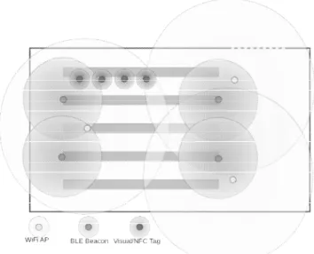
In a hypermarket, for instance (see Fig. 4), when approaching the main entrance, with ample corridors, the accuracy achieved with the Wi-Fi signals could be enough. But inside it is necessary more accuracy, since we have smaller spaces and when it is necessary to give directions to enter in a corridor the navigation system can, mistakenly, indicate the next corridor instead of the correct one. That’s a place where some BLE beacons can help, since they permit a better accuracy. Inside the narrower corridors, since they have delimited space, it’s possible to navigate based on the inertial sensors. But to help finding the products on the shelf it will be necessary a greater accuracy, difficult to manage without a different method. Like visual tags, captured with the smartphone camera, or NFC tags, readed by the respective smartphone sensor and even more precise for a BVI.
Figure 4. Hypermarket layout with an illustration of the range/accuracy of different data sources
The database stores the information necessary to the positioning and navigation calculations, like fingerprinting data for Wi-Fi positioning, or the landmarks or tag information for visual positioning, or the map of the local building. This database can be updated whenever the user enters a referenced building, by Wi-Fi or Bluetooth. The transmitted data could also inform about the positioning sources available to use in that particular building.
Although based on present technologies, this architecture does not prevent the integration of new ones, like the future standard IEEE 802.11az that will bring enhancements for positioning. Or the use of new sensors integrated on next generation smartphones neither.
IV. CONCLUSION AND FINAL REMARKS Indoor positioning and navigation systems are still challenging, particularly when used by BVI persons. Hybrid techniques have shown better results than single ones and one common solution is to use beacon-based localization together with dead-reckoning. We presented a positioning and navigation system architecture that combines the aforementioned techniques and expands them, by using visual tags and NFC tags, in order to achieve high positioning accuracy when possible. The architecture has the flexibility to only use partial localization sources, so it can be possible to deploy the system in a building by stages, using only the existing Wi-Fi network in the beginning, for a fair accuracy with minimal cost, and gradually implementing other location sources, as BLE beacons for a higher accuracy, and/or tags (visual and/or RF) near points of interest with ever higher accuracy demanding.
The data fusion engine would be addressed in future work as well as the interface between the user and the system.
REFERENCES
[1] X. Li, J. Wang, and C. Liu, “A Bluetooth/PDR Integration Algorithm for an Indoor Positioning System.,” Sensors (Basel)., vol. 15, no. 10, pp. 24862–85, Sep. 2015.
[2] Z. Turgut, G. Z. G. Aydin, and A. Sertbas, “Indoor Localization Techniques for Smart Building Environment,” Procedia Comput. Sci., vol. 83, pp. 1176–1181, Jan. 2016.
[3] R. R. A. Bourne et al., “Magnitude, temporal trends, and projections of the global prevalence of blindness and distance and near vision impairment: a systematic review and meta-analysis,” Lancet Glob. Heal., vol. 5, no. 9, pp. e888–e897, Sep. 2017.
[4] A. Basiri et al., “Indoor location based services challenges, requirements and usability of current solutions,” Comput. Sci. Rev., vol. 24, pp. 1–12, May 2017.
[5] W. Sakpere, M. Adeyeye-Oshin, and N. B. W. Mlitwa, “A State-of-the-Art Survey of Indoor Positioning and Navigation Systems and Technologies,” South African Comput. J., vol. 29, no. 3, pp. 145–197, 2017.
[6] M. A. Al-Ammar et al., “Comparative survey of indoor positioning technologies, techniques, and algorithms,” in Proceedings - 2014 International Conference on Cyberworlds, CW 2014, 2014, pp. 245– 252.
[7] C. BASRI and A. El Khadimi, “Survey on indoor localization system and recent advances of WIFI fingerprinting technique,” in 2016 5th International Conference on Multimedia Computing and Systems (ICMCS), 2016, pp. 253–259.
[8] L. Mainetti, L. Patrono, and I. Sergi, “A survey on indoor positioning systems,” in 2014 22nd International Conference on Software, Telecommunications and Computer Networks (SoftCOM), 2014, pp. 111–120.
[9] J. Xiao, Z. Zhou, Y. Yi, and L. M. Ni, “A Survey on Wireless Indoor Localization from the Device Perspective,” ACM Comput. Surv., vol. 49, no. 2, pp. 1–31, Nov. 2016.
[10] F. Zhou, “A Survey of Mainstream Indoor Positioning Systems,” J. Phys. Conf. Ser., vol. 910, no. 1, p. 12069, Oct. 2017.
[11] Y. Gu, A. Lo, and I. Niemegeers, “A survey of indoor positioning systems for wireless personal networks,” IEEE Commun. Surv. Tutorials, vol. 11, no. 1, pp. 13–32, 2009.
[12] infsoft, “Indoor Positioning and Services.” infsoft GmbH, Großmehring, 2017.
[13] A. Meliones and D. Sampson, “Blind MuseumTourer: A System for Self-Guided Tours in Museums and Blind Indoor Navigation,” Technologies, vol. 6, no. 1, p. 4, Jan. 2018.
[14] Y. Bai, W. Jia, H. Zhang, Z. H. Mao, and M. Sun, “Landmark-based indoor positioning for visually impaired individuals,” in International Conference on Signal Processing Proceedings, ICSP, 2014, vol. 2015– Janua, no. October, pp. 668–671.
[15] G. Legge et al., “Indoor Navigation by People with Visual Impairment Using a Digital Sign System.,” PLoS One, vol. 8, no. 10, pp. 1–1, Oct. 2013.
[16] S. Alghamdi, R. Van Schyndel, and I. Khalil, “Accurate positioning using long range active RFID technology to assist visually impaired people,” J. Netw. Comput. Appl., vol. 41, no. 1, pp. 135–147, May 2014. [17] T. Gallagher, E. Wise, B. Li, A. G. Dempster, C. Rizos, and E. Ramsey-Stewart, “Indoor positioning system based on sensor fusion for the Blind and Visually Impaired,” Indoor Position. Indoor Navig. (IPIN), 2012 Int. Conf., no. November, pp. 1–9, 2012.
[18] T. Gallagher et al., “Indoor navigation for people who are blind or vision impaired: Where are we and where are we going?,” J. Locat. Based Serv., vol. 8, no. 1, pp. 54–73, Jan. 2014.
[19] J. P. Gomes, C. R. Cunha, and R. Mansilha, “Orientação de invisuais em espaços fechados combinando técnicas de multilateração, inerciais e magnéticas, usando redes 802.11 e dispositivos móveis,” in Actas de la 5a
Conferencia Ibérica de Sistemas y Tecnologías de Información, 2010, pp. 299–300.
[20] R. Mansilha, J. P. Gomes, and C. R. Cunha, “A prototype for indoor orientation of blind people combining multilateration, inertial and magnetic techniques, using 802.11 networks and mobile devices,” in Proceedings of the 6th Iberian Conference on Information Systems and Technologies, CISTI 2011, 2011.
[21] A. Alnafessah, M. Al-Ammar, S. Al-Hadhrami, A. Al-Salman, and H. Al-Khalifa, “Developing an Ultra Wideband Indoor Navigation System for Visually Impaired People.,” Int. J. Distrib. Sens. Networks, vol. 12, no. 7, p. 1, Jul. 2016.
[22] P. Gharani and H. A. Karimi, “Context-aware obstacle detection for navigation by visually impaired,” Image Vis. Comput., vol. 64, pp. 103– 115, Aug. 2017.