IOP Conference Series: Earth and Environmental Science
PAPER • OPEN ACCESS
Duality Centre - Suburbs: Origins by the Re-use of
Religious Buildings
To cite this article: Ana Virtudes 2017 IOP Conf. Ser.: Earth Environ. Sci. 95 052017
View the article online for updates and enhancements.
Related content
Beyond the Early Stage of Post-suburbanization: Evidence from Urban Spatial Transformation in Jabodetabek Metropolitan Area
E Sadewo, I Syabri and Pradono
-Monitoring urban transformation in the old foreign concessions of Shanghai from 1987 to 2012
A Lefebvre, T Corpetti and N Courty
-Gravitational duality transformations on
AdS4
Robert G. Leigh and Anastasios C. Petkou
-1
Content from this work may be used under the terms of theCreative Commons Attribution 3.0 licence. Any further distribution of this work must maintain attribution to the author(s) and the title of the work, journal citation and DOI.
Published under licence by IOP Publishing Ltd
1234567890
World Multidisciplinary Earth Sciences Symposium (WMESS 2017) IOP Publishing
IOP Conf. Series: Earth and Environmental Science 95 (2017) 052017 doi :10.1088/1755-1315/95/5/052017
Duality Centre - Suburbs: Origins by the Re-use of Religious
Buildings
Ana Virtudes 1
1 C-MADE, Centre of Materials and Building Technologies, University of Beira Interior, 6200-001 Covilhã, Portugal
Abstract. The nationalization of religious properties; churches, convents and monasteries,
signifying the decline and the end of the religious orders and a selling-off (by auction) of their properties was a universal phenomenon that took place in several countries in different times. In Portugal, this process occurred in 1834 and has contributed greatly to urban transformations. The changing of European cities in the transition to the twenty century has some aspects in common, such as is the resultant transformation of the compact urban fabric to a city with the duality between centre and suburbs, but there are others which are unique and Santarém is one such case. This uniqueness lies not in the result but in the cause of the change: this process means the re-using, transforming and rebuilding of religious spaces and their functions in order to meet new demands for the city. If on the one hand a bullfighting arena, some military buildings or even a prison were the new facilities of the suburbs, a theatre, an archaeological museum, a bank agency, a high school or a housing area for the bourgeoisie on the other hand were to become the new architecture of the city centre in the religious spaces. All the examples mentioned above were to lead to the adjustment of city limits. The city limits ceased to be identified in relation to the city-walls and the concept of a new city was formed by an internal dualism between city centre and suburbs. This process made the example of this city unique and caused a series of unique urban changes. During this peculiar socio-political process in Santarém, the new commercial bourgeoisie arose and its strong desire for land-ownership and buying-up the religious spaces. There were a large number of convents and their location was both inside and outside the city-walls. The city geography was this: it lay on a platform on top of the hill above the Tagus River and this brought in turn some unexpected beauty and quality to the urban design. The transformation of religious spaces was a key factor in urban design. This change occurred within the context of a bourgeoisie in full social ascent, who had their own ambitions for the city. Consequently, the city was fragmented into different spatial areas having different social characters: the city centre was beautiful, regular, healthy and desirable; the suburbs were irregular, unhealthy and a bidonville for citizens with little means.
1. Introduction
This article presents an interpretation about the contribution to centrality of the transformation of the religious spaces in Santarém, after the extinction of the religious orders in Portugal in 1834; called desamortização. As some authors used to say [1] the city has the capacity of changing without destroying itself. This fact had different timings in several countries in Europe such as Portugal, Spain, Italy or France, which decreed the abolition of religious orders. It was a process not only of expectation for filling the empty coffers of the State. Empty since the end of the gold rush from Brazil
1234567890
World Multidisciplinary Earth Sciences Symposium (WMESS 2017) IOP Publishing
IOP Conf. Series: Earth and Environmental Science 95 (2017) 052017 doi :10.1088/1755-1315/95/5/052017
(a Portuguese colony until 1822) and because war: the three French invasions (until 1811) and the civil war between liberals and absolutists (ended in 1834). But it was, at the same time, a means of promoting access to attain the prestigious position of being land owner among the bourgeoisie. The fact of being a land owner was a very prestigious status, which meant, in addition to being wealthy, also the possibility to be member of the local political authorities. These two conditions conferred the possibility of having influence in the city transformation, through a private action being a land owner, and through a public action being a member of local authorities.
This process was also the opportunity for the bourgeoisie to re-assert their previous status of being land owners. This was, on the one hand, because it allowed them to buy religious buildings which were available for sale. On the other hand, it allowed the bourgeoisie to increase the quantity of buildings they owned in the city. By being owners of a greater number of properties the bourgeoisie were able to influence the implementation of new functions in these spaces and thus its influence on the city transformation. In theory, this process would multiply the number of owners and open the opportunity for investment, widen the base of social support for the new regime and make the country a nation of land-owners [2].
However, the weak economy had not only affected the government accounts but also society in general. The elite capitalists were reduced to a small number of buyers, already wealthy or land-owners, who monopolized the best religious lots and left aside the masses. The acquisition of religious property represented access to or the strengthening of owner status, the dubious privilege of being an owner of a small piece of land, hence giving a sense of mastery over a portion (albeit tiny) of the city.
2. Changing of the city by re-using religious spaces: the uniqueness of Santarém
Santarém, a medium city is a pivotal case study in the re-us of religious buildings in the Portuguese cities, during the 19th century and the first years of the 20th century [3, 4]. In social terms the bourgeoisie of this city represented the interests of wealthy individuals, creditors of the state and political-military groups favoured by liberalism, associated with trade activities and agricultural credit. These groups had more political influence, because they were represented in political circles and were the richest among the bourgeoisie. It was basically the public initiative which promoted the transformation and re-using of the religious spaces, under the influence of the bourgeoisie. From the decade of the 1830s until the decade of the 1940s, the urban morphology of this small city located 80 km on the north side of Lisbon was completely transformed. The space inside the walls where the bourgeois were concentrated was being gradually embellished with economic, political and cultural functions that were in harmony with the values of a city centre. In this sense, some authors [5, 6] advocate that the urbanism is an activity which is mixed with the social, political and economic realms of the cities.
The slow incorporation of the religious spaces in the city centre was to signify the change of paradigm in the urban evolution of Santarém, centrality being crucial to it. Even if in Portugal Santarém is not a big city, some aspects that support its urban modernity, at certain moments in history, illustrate the trend of modern urban transformations on a national scale; such as the influence of this process. Peculiar to Santarém was the fact that these transformations occurred in a city previously subject to an important process of decadence resulting from the earthquake of 1755, the 3rd French invasion in 1810-1811 with the army in the city and lastly the civil war which ended in 1834. This sui generis situation of absolute decadence, (an urban space like a corpse among his debris), was comparable to a most beautiful and precious book made of stone, rich in pictorial ornamentations and florals, but destroyed by society. It was not a decadent Paris that Haussmann found. It was not a Barcelona in ruins that Ildefonso Cerdá has found.
It is in this degraded city and fragile scenario that the modern urban transformations in Santarém took place by re-using religious spaces (Figure 1). This process has a double meaning: it was itself a part of the urban decadence, since the religious buildings themselves were part of the ruins; it was on the basis of this expectation from which the city was to emerge from the surface of the debris, with new functions in the religious buildings.
3
1234567890
World Multidisciplinary Earth Sciences Symposium (WMESS 2017) IOP Publishing
IOP Conf. Series: Earth and Environmental Science 95 (2017) 052017 doi :10.1088/1755-1315/95/5/052017
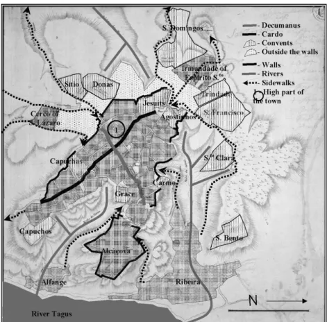
Figure 1. Urban space of Santarém, beginning of 19th century – Portugal (on a map of 19th century of the Portuguese Geographical Institute – IGEO).
The medieval city-walls of Santarém joined together the urban space on the top of the hill at a level of 100 meters: the castle of Alcáçova to the West and the part of Marvila to the East. At the beginning of 19th century with the dawning of modernity, the urban morphology was characterized by: a. the Roman legacy of Cardus and Decumanus as two principal axles of the urban structure; b. the Arab legacy of the narrow streets without exit into the interior of the blocks; c. the main public space inside the city-walls was Marvila square and outside the city-walls there was a public spacious area for markets and bullfights called “Chão-da-Feira”.
The religious spaces were prevalent in the city. The urban morphology was characterized by the impressive presence of many churches, convents, monasteries and chapels. There were thirteen huge religious complexes. Seven of them outside the city-walls (from the West to the North: Sítio, Donas, S. Domingos, Trindade, S. Francisco, S.ta Clara and S. Bento). Six of them inside of the city-walls (Capuchos, Grace, Capuchas, Carmo, Jesuits and Agostinhos).
2.1. Re-using of religious spaces for city centre functions
The convents inside the city-walls were transformed into institutions. This process began with the installation of a High School in the convent of Jesuits in 1843. Localized in the square near the city-gate of Leiria, the High School was to operate in the left wing of the building for one hundred years. In 1943 it was to be transferred to a new building in a new urbanization in S. Bento, designed by the architect João António de Aguiar. A new housing area inspired in the design of garden-city with single houses and great green spaces took the place of the demolished convent of S. Bento (Figure 2).
1234567890
World Multidisciplinary Earth Sciences Symposium (WMESS 2017) IOP Publishing
IOP Conf. Series: Earth and Environmental Science 95 (2017) 052017 doi :10.1088/1755-1315/95/5/052017
Figure 2. Urbanization of Alto of S. Bento – 1939, Santarém, Portugal (architect João António de
Aguiar) (Municipality of Santarém Archive).
There is the need of rethink the urban transformation resulting from the desamortização as a process which happened but which remained unfinished until what remained of the last convent was incorporated in the city land market which was to take place in the decade of 1930 with the plan of urbanization of Alto de S. Bento. This new residential area was the only planned urbanization of Santarém in the place which corresponded to the religious spaces after the nationalization of their properties and it was to close the urban transformation process resulting from the desamortização. It was a new residential area in the place of the demolished convent of S. Bento, inspired by the model of the garden-city. If it has been said that in Portugal there isn't a garden-city, the truth is that we have had examples of garden-residential areas, such as the urbanization of S. Bento, with the typology of single housing and large green spaces. S. Bento is an expansion of the city centre where the bourgeois was living in the decade of 1940.
After being desecrated, the church of S. John of Alporão, located between the castle of Alcáçova and Marvila square, was the second religious building inside the city-walls, re-occupied and with new functions. This building was not demolished but in 1849 was occupied by the Theatre of the city and in 1876 by the Archaeological Museum that still remains there today (Figure 3a). Another example is the church of S. Martinho localized in the street called Conselheiro Figueiredo Leal (in the square of Alporão) was demolished in order to build the new Theatre of the city a substitution for the Theatre in church of Alporão. It was in the decade of 1870 that the construction of the Rosa Damasceno Theatre was concluded. The architecture project of the building was by architect José Luís Monteiro, enforcing the centrality on this part of the city with the presence of an important cultural installation. In the modern city, theatres were to become the symbolic places for leisure and culture for the bourgeoisie, connected with its secular and rationalist character, supported by the scientific progress [7]. In 1938, this building was remodelled by the project of the architect Amílcar Pinto, in order to be adapted to new requirements for sound (Figure 3.b).
5
1234567890
World Multidisciplinary Earth Sciences Symposium (WMESS 2017) IOP Publishing
IOP Conf. Series: Earth and Environmental Science 95 (2017) 052017 doi :10.1088/1755-1315/95/5/052017
a. b.
Figure 3. a) Archaeological Museum in the church of S. John of Alporão – picture from 1948
(Urbanization General Plan of Santarém (1948), photo n. 31, Municipality of Santarém Archive); b) Architectural Project of Theatre Rosa Damasceno, Santarém – 1870s (architect José Luís Monteiro)
(Portuguese Institute of Heritage).
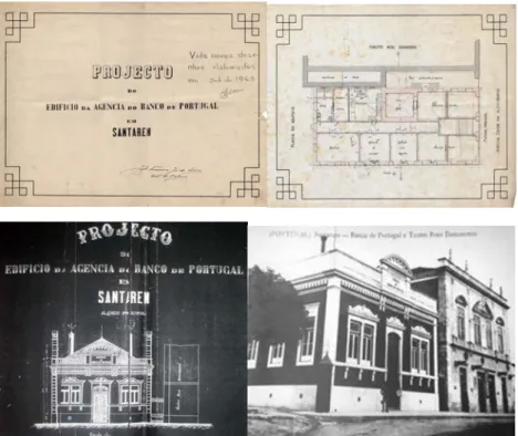
The agency of the Bank of Portugal is set at Santarém in 1899 at Avenue of Count Alto Mearim, built in a land of the demolished church of S. Martinho next Rosa Damasceno Theatre (Figure4). The presence of bank agencies is a landmark in the origins of the modern city. The authors [8] refer that the most popular corners of the urban fabric are disappearing due to the construction of bank agencies.
Figure 4. Architectural Project of Bank of Portugal agency in Santarém – 1899 (architect Amílcar
Pinto) (Bank of Portugal Historical Archive, Projecto_1.jpg, 1899); Theatre Rosa Damasceno (on the right) and Bank of Portugal agency (on the left) – 1880s (Municipality of Santarém Archive) The project and the work of the building were made by Julio de Sousa. The installation of the agencies of the Bank of Portugal in several cities in the last quarter of the 19th century was associated
1234567890
World Multidisciplinary Earth Sciences Symposium (WMESS 2017) IOP Publishing
IOP Conf. Series: Earth and Environmental Science 95 (2017) 052017 doi :10.1088/1755-1315/95/5/052017
with the desire for affirmation of capitalism. The new Bank of Portugal agency in Santarém signified the presence of rich people with money to put in a bank (the rising bourgeoisie class).
The beginning of the urban transformations is easily visible in the convent of Capuchos, localized in the southern limit of the higher part of town inside the city-walls, with the demolition of the buildings, all with the exception of the church. After that a modern building was built on this place as symbol of the hygiene and health, the most important things in urban design. This is so in the case of the first public cemetery, whose construction was accompanied by road reforms in order to rectify the design of the road leading to the new city centre. Along this street there was a poor residential area. It could be argued that the cemetery and the poor residential area were to become a sign of the modern urban evolution on the southern part of the high town as a peripheral area. In the process of centralization, the transformation of this convent was within the walls the exception that happened to become the rule. However, the construction the cemeteries became a very important infrastructure of the 19th century city, which was very well known by the unsanitary conditions, epidemics and low life expectancy [9, 10].
The convent of Grace (Figure 5) localized between the castle of Alcáçova and the Marvila square was sold very cheaply to a private owner and then was transformed into dwellings for several families. In 1872 this convent became part of a Social Assistance Institution “Lar Distrital of S.to António”. Still, the facts illustrating its disregard and neglect led in August of 1882 to the desecration of the tomb of Pedro Álvares Cabral (Portuguese navigator who discovered Brazil in 1500, buried in this church).
Figure 5. Convent of Grace, Santarém, Portugal (Municipality of Santarém Archive)
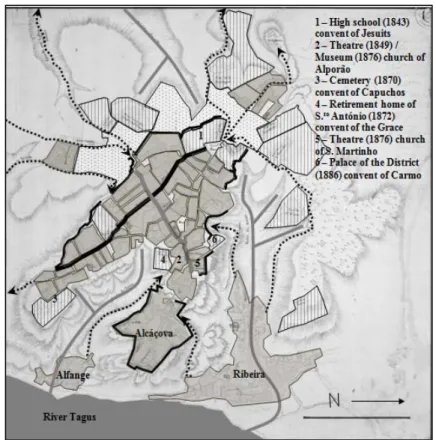
Finally, the example of the convent of Carmo that was demolished in order to build (in 1886) the new “Palace of the District”. In summary, the high school, the Archaeological Museum, the Rosa Damasceno Theatre, the Bank of Portugal agency and the Palace of the District, delimited the new city centre of Santarém inside the walls. The exception was the Cemetery of Capuchos and the poor residential area in their surroundings that became the limits of the new suburbs (Figure 6).
2.2. Transformation of religious buildings in the suburbs
If in the space within the city-walls, the signs of the centrality were visible after the selling of religious buildings, in the course of a lapse of a greater period of time and in the space outside the walls, the modern urban transformations were to become associated with the presence of installations that concretized the social ideas of the city bourgeois, in the “subordinate” periphery. This part of the
7
1234567890
World Multidisciplinary Earth Sciences Symposium (WMESS 2017) IOP Publishing
IOP Conf. Series: Earth and Environmental Science 95 (2017) 052017 doi :10.1088/1755-1315/95/5/052017
modern city has its roots in the transformation process of urban expansion with a boom of the population and a lack of housing [11].
Figure 6. Origins of the city centre in Santarém – Decade of 1880 - Portugal (Author on a map of 19th century of the Portuguese Geographical Institute – IGEO)
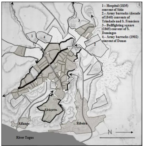
The first of these transformations took place in the convent of Sítio, where in 1835 the hospital began to function (Figure 7).
Figure 7. Convent of Sítio (1st floor / ground floor) Santarém, Portugal (Portuguese Army Archive, 3527_XVII-3-31-43.jpg / 3527_XVIII-3-31-43.jpg)
The next example of transformation was the installation of army barracks in the convents of S. Francisco (Figure 8) and Trindade (Figure 9) in the decade of 1840. These new functions are features of the peripheral areas.
1234567890
World Multidisciplinary Earth Sciences Symposium (WMESS 2017) IOP Publishing
IOP Conf. Series: Earth and Environmental Science 95 (2017) 052017 doi :10.1088/1755-1315/95/5/052017
Figure 8. Army barracks (convent of S. Francisco) – 1866 Santarém, Portugal (Portuguese Army
Archive, 3543_IV-3-31-43.jpg).
The Bullfighting arena was inaugurated in 1865 in the place of the demolished convent of S. Domingos. The importance of having this sort of public building emerged when the bullfighter began to be a professional way of living [12]. In the beginning of the 20th century another army barracks occupied the convent of Donas. These functions, associated as they were with the presence of live animals, disease, the necessity of ample spaces and insalubrities, were incompatible with the urban centre and, therefore, they occupied the suburbs (Figure 10).
Figure 9. Army barracks (Convent of Trindade) – 1866 Santarém, Portugal (Portuguese Army
Archive, 3543_III-3-31-43.jpg).
A bullfighting arena, military buildings or a “village” inspired in the garden-city are the architectures of the peripheries, and these took the place of the old convents. These examples reflect the bourgeois and their influence on the design of the new public services. There was a peculiar socio-political set-up in place that influenced these urban transformations.
In summary, the construction of the periphery was shown by the re-use of religious spaces, by functions and modern installations where the scholastic and intellectual components of modern town planning advanced with a strong component that rationalized the city by parts, with sporadic and dislocated actions between them. These transformations contributed to form the model of Santarém as an open and extended city, i.e., no longer having its limits within the city walls, which are according to some authors [13] the reason for the beauty of the old towns.
Finally, the political instances of the modern State, local political power asserting itself and the bourgeoisie in their social ascent were the agents of this process that, in terms of urban space was developed in the functional plan (with the restructuring of the city according to the demands of capitalism in its phase of industrial development). In parallel it was developed as well formally or symbolically (with the adaptation of ways for the bourgeoisie to represent themselves). However, the urban transformations gradually produced by this Hera, only later on will be clearly understood [14].
9
1234567890
World Multidisciplinary Earth Sciences Symposium (WMESS 2017) IOP Publishing
IOP Conf. Series: Earth and Environmental Science 95 (2017) 052017 doi :10.1088/1755-1315/95/5/052017
Figure 10. Suburbs of Santarém – Beginning of 20th century, Portugal (on a map of 19th century of the Portuguese Geographical Institute – IGEO).
3. Conclusions
This article argued that the process of spatial transformation that occurred in the city of Santarém after the selling of religious buildings was driven by social and political forces commanded by an ascending bourgeoisie. This bourgeoisie desired to transform the city according to a centralized model in which the city centre would be the main stage for displaying its influence. To this extent, this process was similar to other processes that occurred in other cities at the time, in Portugal and elsewhere in Europe. What distinguishes this city is the fact that the success of study and understanding the city of today depends on a deep understanding of the historical urban evolution and of the urban growth process. This knowledge takes us back to the urban transformations of the 19th century with the compact city, bounded by walls, with an urban fabric markedly medieval. These transformations created the dichotomy of centre / periphery. For the first time in history, the city was fragmented into different spatial areas with different social characters. The centre was beautiful, regular, healthy and desirable. The periphery was irregular, unhealthy and a bidonville for citizens with no means. There have been several experiences of this phenomenon in Europe, rigorously planned or not, both large scale or surgical. However, this city is unique not because of the consequence (the duality centre / suburb) but because of the re-use of religious buildings. This fact implied the decline of the religious orders and a necessity to sell convents, influencing the quality of the architecture in the newly created peripheries.
A bullfighting arena, military buildings or a “village” inspired in the garden-city are the architectures of the peripheries, and these took the place of the old convents. These examples reflect the bourgeois and their influence on the design of the new public services. There was a peculiar socio-political set-up in place that influenced these urban transformations.
1234567890
World Multidisciplinary Earth Sciences Symposium (WMESS 2017) IOP Publishing
IOP Conf. Series: Earth and Environmental Science 95 (2017) 052017 doi :10.1088/1755-1315/95/5/052017
This process made the shown example exceptional and exclusive. Perhaps it was the sheer number of convents, their location and geography that made this city unique, bringing with it some unexpected beauty. The re-use of religious buildings was to unleash the dynamics for rapid urban transformation in the historic urban space within the city-walls, ending in the decade of 1880, by means of the installation of institutional functions, with the State acting as direct agent of the changes in the face of the interests of the local bourgeoisie.
The structural space at the beginning of the 19th century was characterized by a system of urban centres and it has survived, and they in turn became the very basic conditions from which the modern transformations of this city sprang. These changes were progressively structured according to the dichotomy of the centre-periphery model and occurred with no prior plan from the moment in which the interests of the local bourgeoisie became evident. This global transformation, not exclusive to this city, was marked by aspects analogous to those of other European cities of the time: in Santarém the re-use of religious spaces was the motto that inaugurated the process of the construction of the modern city and possibly, more far-reaching processes among those which characterize its modernity and more particularly by its relative intensity, within a Portuguese context of reference.
Acknowledgements
This work is supported with Portuguese national funds by FCT - Foundation for Science and Technology within the UID/ECI/04082/2013 project.
References
[1] Aymonino, C. (1971) “Origins and development of the modern city” (in Spanish), Barcelona: Gustavo Gili.
[2] Lains, P. et al. (org.) (2005) “Economic history of Portugal (1700 – 2000)” (in Portuguese), Vol. II: the 19th century (in Portuguese), Imprensa de Ciências Sociais.
[3] Virtudes, A. (2008) “Modern Urban Transformations in Santarém (1834-1948)” (in Portuguese). Doctoral Thesis (in portuguese/spanish), University of Valladolid, Spain. [4] Virtudes, A. (2015) “Modern Urbanistic in Portugal: Santarém as a case study (1834-1948)” (in
Portuguese), Nota de Rodapé Editores, Lisbon / Paris.
[5] Hall, P. (1996) “The cities of tomorrow” (Spanish version), Barcelona: Serbal.
[6] Sica, P. (1981) “History of Urbanism in the 20th century” (in Spanish), Madrid: Instituto de Estúdios de Administracion Local.
[7] Piccinato, G. (1993) “The construction of urbanistic: Germany 1871/1914” (in Spanish), Barcelona: Oikos-tau-Vilassar de Mar.
[8] Mora, A. (1980) “The city centres: towards the popular recuperation of the city” (in Spanish), Madrid: Nuestra Cultura.
[9] Gravagnuolo, B. (1998) “History of Urbanism in Europe 1750-1960” (in Spanish), Madrid: Akal.
[10] Samonà, G. (1978) “Urbanism and the Future of the City” (in Italian), Roma: Universale Laterza.
[11] Ashworth, W. (1974) “Modern Urbanism in the Great Britain - 1800-1950” (Italian version), Milano: Franco Angeli.
[12] Quirós, F. (1991) “The Spanish cities in the 19th century” (in Spanish), Junta de Castilla y Léon, Ámbito, Valladolid.
[13] Unwin, R. (1909) “The practice of Urbanism, an introduction to the art of projecting cities and neighbourhoods” (Spanish version), Barcelona: Gustavo Gili.