Raphael de Vicq Ferreira da Costa
Doutorando
Universidade Federal de Ouro Preto. Escola de Minas – Departamento de Geologia Ouro Preto – Minas Gerais – Brazil
Mariangela Garcia Praça Leite
Professora Associada
Universidade Federal de Ouro Preto, Escola de Minas – Departamento de Geologia Ouro Preto – Minas Gerais – Brazil
Fellipe Pinheiro Chagas Mendonça
Doutorando
Universidade Federal de Ouro Preto, Escola de Minas – Departamento de Geologia Ouro Preto – Minas Gerais – Brazil
Hermínio Arias Nalini Jr.
Professor Associado IV
Universidade Federal de Ouro Preto, Escola de Minas – Departamento de Geologia Ouro Preto – Minas Gerais – Brazil
Geochemical mapping
of arsenic in surface waters
and stream sediments of the
Quadrilátero Ferrífero, Brazil
Mapeamento geoquímico do arsênio em
águas superficiais e sedimentos fluviais
no Quadrilátero Ferrífero, Brasil
Abstract
A regional study on the arsenic concentration in surface waters and stream sedi-ments, with a density of one sample every 13 km2, was carried out for the irst time in the Quadrilátero Ferrífero (Brazil). The region was divided into 3rd order catchment basins, in which 512 areas were sampled. The arsenic concentration was determined in waters and stream sediments after partial digestion with the aid of ICP-OES. The arsenic values found in surface waters ranged from 57.70 to 414 µg.L-1, while for stream sediments, arsenic concentrations ranged from 0.63 to 1691 mg.kg-1, and from the 512 sampling points, 135 (26%) had arsenic concentrations above the limit of detection, which was 0.63 mg.kg -1. It was also found that 106 3rd order catchment basins had val-ues above the third quartile, (5.09 mg.kg-1). The results show that high concentrations of this element are strongly related to the presence of Nova Lima rocks that contain minerals rich in arsenic. However, the anthropogenic inluence in such high concentra-tions cannot be ruled out, as the region has a history of over 300 years of gold mining.
Keywords: Geochemical Mapping, Arsenic, Surface water, Stream sediments,
Quadri-látero Ferrífero
Resumo
Um estudo regional da concentração do arsênio em águas supericiais e sedi-mentos luviais com uma alta densidade de amostragem de uma amostra para cada 13 km2 foi conduzido pela primeira vez no Quadrilátero Ferrífero (Brasil). A região foi dividida em bacias de 3ª ordem, sendo amostrados 512 trechos nessas bacias. A concentração de As foi determinada nas águas e nos sedimentos, após digestão par-cial, com o auxílio de um ICP-OES. Os valores de arsênio encontrados nas águas supericiais variaram entre 57.70 e 414 µg.L-1. Já para os sedimentos de corrente, as concentrações oscilaram entre 0.63 e 1691 mg.kg-1, sendo que dos 512 pontos de amostragem 135 (26%) apresentaram concentrações de arsênio acima do limite de detecção, que é de 0,63 mg.kg -1. Também foram encontradas 106 bacias de 3ª ordem com valores acima do 3º quartil (5.09 mg.kg-1). Os resultados mostram que as eleva-das concentrações deste elemento estão fortemente relacionaeleva-das com a presença de rochas do grupo Nova Lima, que contém minerais ricos em arsênio. Porém, a inlu-ência antrópica na existinlu-ência destas elevadas concentrações não pode ser descartada, já que a região apresenta um histórico de mais de 300 anos de exploração de ouro.
Palavras-chave: mapeamento geoquímico, arsênio, águas supericiais, sedimentos de
Geosciences
Geociências
corrente, Quadrilátero Ferrífero.
1. Introduction
Arsenic is a trace element, whose average concentration in the earth's crust has been set to values between 1.0 (Taylor and McLennan 1995) and 4.8 ppm (Rudnick and Gao 2003). Its occur-rence is associated with certain types of minerals, mainly arsenopyrite (FeAsS), loellingite (FeAs2), realgar (As4S4) and arsenian pyrite (FeS2), which can be released to waters, soils and sediments by oxidation processes of these sulides, and immobilized via adsorption into iron, aluminum and manganese oxides/ hydroxides or into clay minerals (De-schamps et al. 2003). These processes
occur naturally but can be intensiied by the action of mining activities, with the exposure of large volumes of rocks.
The occurrence of high arsenic concentrations in various environmental compartments, whether natural or am-pliied by human activities, has become a public health problem, greatly increasing the concern of society and the scientiic community regarding human contami-nation by this element (Fewtrell et al.
2005; Ravenscroft, 2009). According to
Reimann et al. (2009), this was the irst
chemical element to be recognized for its carcinogenic properties, being used as a poison since the times of the Romans. The inorganic form is recognized as the most harmful to humans, and chronic exposure can cause serious metabolic problems, including hyperkeratosis, skin cancer, lung cancer, nervous sys-tem disorders, increased frequency of miscarriages and other serious diseases (Abernathy et al. 1998).
However, the most common form of human exposure is through consump-tion of contaminated water (Matschullat et al. 2000; Nordstrom, 2002). Not sur-prisingly, the interest in arsenic exponen-tially increased after incidents occurred in Bangladesh, West Bengal, India and Mexico caused by consumption of con-taminated ground water extracted from aquifers located in arsenic geological formations (Matschullat, 2000, Smith et al. 2002; Neumann et al. 2010).
Despite dozens of published ar-ticles, particularly at the end of the last century, the anthropogenic contribution
to the high arsenic concentrations in various environmental compartments is not well deined, being a source of much debate. However, determining the natural abundance of arsenic is essential not only to support the analysis and environmental monitoring, but also to support actions to combat pollution (De-schamps et al. 2003). In this sense, with
the introduction of new digital mapping technologies, geochemical maps have as-sumed an increasing relevance in recent years (Gielen 1998). These georeferenced maps allow observing the variation of the abundance of some chemical element in a speciic area, thus contributing to the recognition of regions with anomalous values and contributing to the identiica-tion of its main sources, whether natural or linked to human activities (Plant et al. 2001).
In this context, the present study aimed to perform the mapping of arsenic concentrations in water and stream sedi-ments of the Quadrilátero Ferrífero using data of 512 sampling points distributed over its 7,000 km2.
Study Area
The Quadrilátero Ferrífero
The Quadrilátero Ferrífero is one of the richest regions in economic minerals in the world, covering an area
of approximately 7,000 km2, whose
exploration history dates back to the last decades of the seventeenth century.
The region includes fully or partly 35 municipalities in the mid region of the state of Minas Gerais, Brazil (Figure 1), with a population of over 4,135,000 inhabitants (IBGE, 2010).
Mining is still among the
pro-ductive activities that support the region's economy, highlighting the current iron exploitation, which con-tributes with 26.8% of the GDP(Gross domestic product) of Minas Gerais (IBGE, 2010).
Figure 1
Geologic map of the QF region, showing the distribution of basement crystalline rocks, Rio das Velhas Super-group, Minas Supergroup Cenozoic Co-vers and the location of the sample points.
Quadrilátero Ferrífero Region
Cenozoic covers Minas Supergroup Rio das Velhas Supergroup Basement crystalline rocks 512 Sample sites
0 12,5 25 Km
44º30’0’’W
20º20’0’
’S
20º20’0’
’S
19º40’0’
’S
44º0’0’’W 43º0’0’’W 43º0’0’’W
References Basin
Num-ber of Sampling
Points
As concentration
Water (µg.l-1) Stream Sediments (mg.kg-1)
Min Mean Max Min Mean Max
Borba et al. 2000
Velhas River Basin – Nova
Lima
11
2
- 160
20
- 2830
Carmo River Basin – Ouro Preto e Mariana
8 - 30 - 860
Con-ceição
River Basin –
Santa Bárbara
7 - 8 - 135
Matschullat et al. 2000
Nova Lima and
Santa Bárbara
18 (water) and 15 (stream
sedi-ments)
0.4 30.5 350 22 350 3200
Deschamps et al. 2002
Nova
Lima 24 - - - 47 - 3300
Santa
Bárbara 18 - - - 22 - 160
Mariana 9 - - - 22 - 860
Borba et al. 2003
Velhas River Ba-sin– Nova
Lima
9 3 67.2 349 34 583.5 2830
Carmo River Basin – Ouro Preto and
Mariana
8 (water) and 7 (stream
sedi-ments)
1.7 116.7 830 105 819.8 4709
Con-ceição
River Basin–
Santa Bárbara
13 (wa-ter) and 6 (stream
sedi-ments)
1 7.7 74 29.5 73.2 153
Pimentel et al. 2003
Munici-palities of Ouro Preto and
Mariana
22 (wa-ter) and 4
(rocks) 0.05 0.36 2.3 0.11 60 139
Matschullat et al. 2007
Nova
Lima (water) 69 and 39 (stream
sedi-ments)
2.2 49 350 40 140 3300
Santa
Bárbara 0.4 1.8 3.1 15 47 170
Parra et al. 2007
Con-ceição
River Basin
25 - - - 4.91 51.0 89.0
Varejão et al. 2010
Carmo River Basin – Ouro Preto and
Mariana
4 36.7 54.6 68.3 68.8 1773.9 3939
Table 1 Summary of the main studies on arsenic in waters
Five main lithostratigraphic units are found in the Quadrilátero Ferrífero with ages ranging from the Archean: Metamorphic Complex (Noce, 1995; Alkmim and Marshak, 1998) and Rio das Velhas Supergroup (Alkmim and Marshak , 1998), to the Protero-zoic: Minas Supergroup and Itacolomi Group (Dorr II, 1969; Alkmim and Marshak, 1998), and occurrences of maic and granitic intrusions of several generations (Dorr II, 1969; Marshak and Alkmim, 1998). Its richness in min-eral resources and enormous structural and lithological variability directly in-luence the distribution and geochemi-cal characteristics of its waters, soils and sediments.
In the Quadrilátero Ferrífero,
arsenic has a close relationship with gold deposits present in minerals such as arsenopyrite, löllingite or as an impu-rity in arsenopyrite (Borba et al. 2000;
Figueiredo et al. 2006).
These gold deposits are associated with shear zones that cross rocks from the Nova Lima Group, base of the Rio das Velhas Supergroup, or are located at the base of the Minas Supergroup, near the contact with the Nova Lima Group, in quartz and carbonate veins (Borba et al. 2000; Matschullat et al.
2000; Mello et al. 2006).
Its genesis is related to hydrother-mal processes that follow successive deformation phases recorded in the geologic history of the Quadrilátero Ferrífero (Barbosa and Sabaté, 2004)
Although the presence of arse-nic in waters and sediments of the Quadrilátero Ferrífero has been long recognized, there are few studies that speciically address this issue.
Table 1 shows a summary of the most important studies. As observed, the works developed so far have focused on only 3 regions of the Quadrilátero Ferrífero: in the municipality of Nova Lima, the Velhas River Basin; in the municipalities of Ouro Preto and Mariana, the Carmo River Basin, and in the municipality of Santa Barbara, the Conceição River Basin.
On average, these studies relied on only 17 water sampling points and 13 points for the collection of sediments, featuring local studies.
2. Methodology
2.1 - Sampling points
The choice of the sampling points was based on methodology proposed by Bolviken et al. (1996), with water
and sediment collection carried out in
3rd order stretches (Strahler, 1952) of catchment basins. In the present work, these stretches were determined based on the hydrographic map of the region
on a 1:25,000 scale, provided by the Institute of Water Management of the State of Minas Gerais (IGAM), totaling 512 sampling points (Figure 1).
2.2 - Sample collection and treatment
Water samples were collected at the center of each stretch, iltered with the aid of a cellulose acetate membrane (Millipore 0.45 µm) and acidiied with three drops of nitric acid (USEPA, 2001).
Then, they were sent for reading in Inductively Coupled Plasma Optical Emission Spectrometry (ICP-OES), la-bel SPECTRO / MODEL Ciros CCD at the Laboratory of Geochemistry of the Federal University of Ouro Preto, where the As concentration was analyzed.
As there is no standard method-ology for sediment collection aimed at geochemical characterization, the adopted methodological procedures
aimed to be as representative as pos-sible, based on the characteristics of stream sediments sampled.
Thus, nine samples were ob-tained from each stretch. Thus, three subsamples were collected from a region of rifles, 3 subsamples from a region of pools and 3 subsamples from an area of transition between these two morphologies.
For each morphological area, samples were collected at the right bank, left bank and center of the river, and samples collected at the banks were collected at a distance of 0.50 m from the riverbed.
Also in the ield, the subsamples
were mixed so as to obtain a repre-sentative sample of the stretch. After complete homogenization, quartering was performed to obtain a sample of 500 g, which was packed in plastic bags, according to recommendations of EPA (Environmental Protection Agency) (USEPA, 2001).
In the laboratory, samples were dried under a controlled temperature at 40 ± 5°C, crushed, sieved and the sieve fraction smaller than 0.063 μm was digested in aqua regia (Calmano and Forstner 1996). Once digested, the inal product was analyzed in ICP-OES, where the arsenic content of each sample was determined.
2.3 - Statistical processing and map presentation
With the aid of the ArcMap® 9.3 software and based on the geological map of the Quadrilátero Ferrífero on a 1:25,000 scale (Lobato et al. 2005),
the percentage of all lithologies and geo-logical formations that make up each of the 3rd order catchment basins sampled was calculated.
With the results, basic statisti-cal parameters were determined and data normality was evaluated by the Komolgorov-Smirnov test.
The methodology deined by Rei-mann et al. (2005) was used to
deter-mine the background values, with the construction of boxplot-type curves and
cumulative frequency histograms. Based on the geochemical analysis results and using the ArcMap® 9.3 software, maps showing the arsenic concentration in waters and stream sediments were con-structed using a 1:150,000 scale and the IDW (inverse distance weight) method for interpolation.
3. Results and Discussion
Figures 2 and 3 respectively show the geochemical maps with the arsenic distribution in waters (Figure 2) and
stream sediments (Figure 3) of the Quadrilátero Ferrífero.
Figure 4 shows the combined
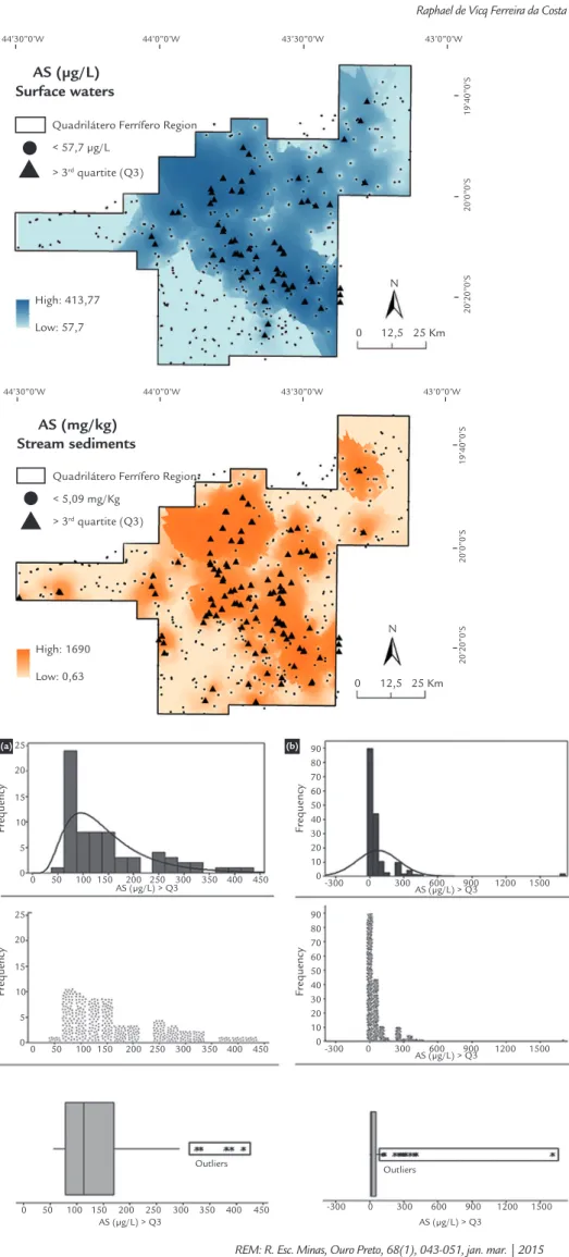
Figure 2 Geochemical map showing the variation of As concentrations found in surface waters of the Quadrilátero Ferrífero.
Figure 3 Geochemical map showing the variation of As concentrations found in stream sediments of the Quadrilátero Ferrífero.
Figure 4 Combined graphic representation showing histogram, data density and boxplot to determine the background of water samples (A) and stream sediments (B) of the Quadrilátero Ferrífero.
44’30’’0’W
20’20’
’0’S
20’0’
’0’S
19’40’
’0’S
44’0’’0’W 43’30’’0’W 43’0’’0’W
Quadrilátero Ferrífero Region
< 57,7 µg/L
> 3rd quartite (Q3)
High: 413,77
Low: 57,7 0 12,5 25 Km
N
AS (µg/L) Surface waters
25
20
15
10
5
0
0 50 100 150 200 250 300 350 400 450
Fr
equency
Fr
equency
Fr
equency
Fr
equency
AS (µg/L) > Q3
25
20
15
10
5
0
0 50 100 150 200 250 300 350 400 450
0 50 100 150 200 250 300 350 400 450 AS (µg/L) > Q3
AS (µg/L) > Q3
AS (µg/L) > Q3 90
80 70 60 50 40 30 20 10 0
-300 0 300 600 900 1200 1500
AS (µg/L) > Q3 90
80 70 60 50 40 30 20 10 0
-300 0 300 600 900 1200 1500
-300 0 300 600 900 1200 1500
Outliers Outliers
44’30’’0’W
20’20’
’0’S
20’0’
’0’S
19’40’
’0’S
44’0’’0’W 43’30’’0’W 43’0’’0’W
Quadrilátero Ferrífero Region
< 5,09 mg/Kg
> 3rd quartite (Q3)
High: 1690
Low: 0,63
0 12,5 25 Km
N
AS (mg/kg) Stream sediments
The arsenic values in surface water ranged from < 57.70 to 414 µg. L-1. A num-ber of 70 sampling points (13.7%), have values of arsenic above the quantiication limit of 57.7 μg. L-1, which in this case was considered as the background value, because most of the sample points (86.7%) showed concentrations up to this level. As surface waters can have arsenic concentra-tions ranging from 0.5 µg L-1 to more than 5000 µg L-1, with the most common values below 10 µg L-1, and often less than 1 µg L-1 (Smedley and Kinniburgh, 2002), the obtained high limit of quantiication value did not allow a more detailed statistical analysis of water samples. However, the distribution of points with values above the limit of quantiication show important trends, with waters rich in As occurring not only in the Carmo River (Borba et al. 2000; Deschamps et al. 2002; Borba
et al. 2003; Varejão et al. 2011), Velhas
River (Borba et al. 2000; Matschullat et al. 2000; Deschamps et al. 2002; Borba et al. 2003, Matschullat et al. 2007) and
Conceição River basins (Borba et al. 2000;
Matschullat et al. 2000; Deschamps et al.
2002; Borba et al. 2003, Matschullat et al. 2007), but also in the Paraopeba and
Piracicaba River basins.
For stream sediments, arsenic con-centrations ranged from < 0.63 to 1691
mg.kg-1, and from the 512 sampling
points, 135 (26%) had arsenic concentra-tions above the limit of quantiication, which was 0.63 mg.kg -1. It was also found that 106 3rd order catchment basins had values above 5.09 mg.kg-1, considered the background value. These sampling points are mostly composed of tributaries of the main local rivers, and another 35 in rural communities or suburban localities.
These locations often have low-income and low-education populations, which are not aware of the risk they are being exposed to.
The highest values found in stream sediments (between 33 and 1691 mg.kg-1) are related to a substratum composed of sericite- chlorite-quartz schist, sericite schist, carbonaceous schist, quartz-mica-chlorite schist and quartz-mica-chlorite schist, rocks that compose the Rio das Velhas Super-group, Nova Lima Group (Figure 5).
Among the sixteen 3rd order catch-ment basins with the highest concentra-tions (101.7 to 1691 mg.kg-1), fourteen have an area greater than 60% draining on the above mentioned rocks (Table 2), which indicates a strong relationship between the lithological type and the pres-ence of arsenic in the sediment (Figure 5 and Table 2).
Figure 5
Map showing the distribution of the Nova Lima Group and the sampling points with the highest As concentrations in stream sediments.
Quadrilátero Ferrífero Region
Nova lima group
Above 5,09 mg/Kg
Above 57,7 µg/L
Sediment samples
Water samples
0 12,5 25 Km N
44º30’0’’W 44º0’0’’W 43º30’0’’W 43º0’0’’W
19º40’0’
’S
20º0’0’
’S
20º20’0’
’S
Table 2
Relationship between
the percentage of occurrence of rocks from the Nova Lima Group in 3rd order
catchment basins of the Quadrilátero Ferrífero and as values found in the sediments analyzed.
Rocks from the
Nova Lima Group
As concentration (mg.kg-1)
Mean Standard deviation Minimum Q1 (25%) Median (50%) Q3 (75%) Maxi-mum
≤ 20 19.63 24.52 0.63 0.63 5.37 8.71 83.70
20 < x ≤
30 21.87 29.86 0.63 0.63 5.37 8.71 83.70
30 < x ≤
40 56.2 87.2 0.63 0.63 13.68 26.82 122.6
40 < x ≤
50 73.8 116 0.63 3.8 17.60 32.27 374.1
50 < x ≤
60 79.38 105.6 0.63 5.6 21.46 48.35 374.1
60 < x ≤
70 90.4 128 3.45 7.1 30.83 62.91 407.4
Analyzing the relationship between geology and the arsenic values obtained (Table 2), it appears that the basins with the highest percentages of rocks from the Nova Lima Group had Q3 values far greater than any other rock type. When considering the rock types outcropping in these basins, basins with more than 50% of their area on sericite-chlorite-quartz schist have 75% of rivers with arsenic concentrations up to 48.35 mg.kg -1. On the other hand, basins with more than 60% of their area draining on sericite schist and carbonaceous schist showed Q3 value equal to 62.91 mg.kg-1, and inally, rivers that cross basins with over 70% of quartz- mica-chlorite schists and chlorite schists have Q3 value of 104 mg.kg-1. This analysis is particularly interesting when these values are compared to data ob-tained from other lithologies predominat-ing in the IQ such as itabirites and
hema-tites, dolomites and limestones, gneisses and granites, ferruginous quartzites, and various types of phyllites, which showed signiicantly lower arsenic concentrations, with Q3 values near zero.
Most of the high As concentrations found in Quadrilátero Ferrífero, either in waters or in stream sediments, are derived from rocks rich in this element. Conirming this hypothesis, it was found that several points considered anomalous were within Conservation Units (CUs) or Permanent Preservation Areas (PPAs), in which, theoretically, human interference is minimized. Examples are OP 23 (306.2 mg.kg-1), OP 24 (130 mg.kg-1), OP 30 (374.1 mg.kg-1) and OP 31 (101.7 mg.kg -1), located in the PPA of Cachoeira das Andorinhas, and OP 35, OP 36 and OP 38 that are within the Uaimii forest, which have As values in the sediments above 49.7 mg.kg-1.
According to the map shown in Fig-ure 5, it appears that most of the anoma-lies are located within the mid-northern region of the IQ, which despite having geological substratum rich in arsenic, is also characterized as having a high con-centration of mining companies exploiting gold in Nova Lima, Sabará and Caeté, and iron in Nova Lima, Ouro Preto, Itabirito, Sabará, Santa Barbara and Caeté. Further-more, much of the Quadrilátero Ferrífero region was intensively exploited for the re-moval of gold between the seventeenth and nineteenth centuries, showing evidence of extraction processes in this period, includ-ing mines and waste dumps (Fonseca et al.
2001). The presence of mining activity for the removal of gold, in the current or past centuries, can accelerate the availability of elements for the environment, including As (Ripley et al. 1996; Matschullat et al. 2007, Espinosa et al. 2009).
4. Conclusions
A regional study on the arsenic con-centration in surface waters and stream sediments, with a robust density of one sample every 13 km2, was carried out for the irst time in Quadrilátero Ferrífero (Brazil). This enabled the construction of geochemical maps with the spatial distribution of this element, not avail-able so far.
High arsenic concentrations, po-tentially harmful to human health, were found in both waters and stream
sediments. In the case of waters, values greater than 57.70 µg. L-1 were found in all three major basins that cross the Quadrilátero Ferrífero: Velhas River, Doce River and Paraopeba River, and this is the irst time that such concentra-tions have been reported in the Parao-peba River Basin.
In relationship to stream sedi-ments, one ifth of the sampling points
showed values above 5.09 mg.kg-1.
Points whose concentrations were
above 101 mg.kg-1 occurred in basins with 60% or more of their area formed by rocks that compose the Nova Lima Group, Rio das Velhas Supergroup.
Although data have shown that arsenic occurs naturally in the Quadri-látero Ferrífero, the possibility that hu-man action has contributed to increase these concentrations cannot be ruled out, particularly in areas where there are still caves and waste dumps from gold mining of ancient centuries.
5. Acknowledgements
The authors thankfully and gladly acknowledge the inancial support of
the institutions CNPq, FAPEMIG and mainly CAPES for the scholarship Proc.
no 10228/13-6.
6. References
ABERNATHY, C. O., CALDERON, R. L., CHAPPELL, W. R. Arsenic exposure
and health effects. San Diego, California: Elsevier, 1998.
ALKMIM, F. F., MARSHAK, S. Transamazonian Orogeny in the Southern São Fran-cisco Craton Region, Minas Gerais, Brazil: evidence for Paleoproterozoic collision and collapse in the Quadrilátero Ferrífero. Precambrian Research, v. 90, p. 29–58, 1998.
BARBOSA, J. S. F., SABATÉ, P. Archean Paleoproterozoic crust of the São Francis-co Craton, Bahia, Brazil: geodynamic features. Precambrian Research, v. 133, p. 1-27, 2004.
BERNASCONI, A. Archaean gold mineralization in central Brazil: a review. Minera-lium Deposita, v. 20, p. 277-283, 1985.
141-166, 1996.
BORBA, R. P., FIGUEIREDO, B. R., RAWLINS, B., MATSCHULLAT, J. Arsenic in Water and Sediment in the Quadrilátero Ferrífero, State of Minas Gerais, Brazil.
Applied Geochemistry, v. 15, n. 2, p. 181-190, 2000.
BORBA, R. P., FIGUEIREDO, B. R., MATSCHULLAT, J. Geochemical distribution of arsenic in waters, sediments and weathered gold mineralized rocks from Qua-drilátero Ferrífero, Brazil. Environmental Geology, v. 44, n. 1, p. 39-52, 2003.
BORBA, R. P., FIGUEIREDO, B. R. A inluência das condições geoquímicas na oxi-dação da arsenopirita e na mobilidade do arsênio em ambientes supericiais tropi-cais. Revista Brasileira de Geociências, v. 34, n. 4, p. 489-500, 2004.
CALMANO, W., FÖRSTNER, U., SALOMONS, W., ALLAN, R. Sediments and
to-xic substances: environmental effects and ecototo-xicity. New York: Springer, 1996.
COSTA, A. T. Registro histórico de contaminação por metais pesados, associadas à exploração aurífera no alto e médio curso da bacia do Ribeirão do Carmo, QF: um estudo de sedimentos de planícies de inundação e terraços aluviais. Ouro
Pre-to: Departamento de Geologia, Universidade Federal de Ouro Preto, 2007. 257 p. (Tese de Doutorado).
DESCHAMPS, E., CARNEIRO, M. E. D. P., CIMINELLI, V. S. T., PETER, W., RAMOS, A. Arsenic sorption onto soils enriched in Mn and Fe minerals. Clays and Clay Minerals, v. 51, p. 198–205, 2003.
DORR, J. N. Physiographic, stratigraphic, and structural development of the Quadri-látero Ferrífero, Minas Gerais. USGS Professional Paper: 641-A, 1969.
FEWTRELL, L., FUGE, R., KAY, D. An estimation of the global burden of disease due to skin lesions caused by arsenic in drinking water. Journal of Water and He-alth, v. 3, n. 2, p. 101–107, 2005.
FIGUEIREDO, B. R., BORBA, R. P., ANGÉLICA, R. S. Arsênio no Brasil e expo-sição humana. In: SILVA, C. R. da et al. Geologia médica no Brasil - efeitos dos materiais e fatores geológicos na saúde humana e meio ambiente. Rio de Janeiro:
CPRM, 2006.
FONSECA M., SOBREIRA F., RAINHO M. E., OLIVEIRA M. Unbridled develo-pment of urban space and its implications on the preservation of landmarks – the Morro da Queimada archeological site, Ouro Preto, Brazil. Cities, v. 18, n. 6, p.
381–389, 2001.
GIELEN, E. Los SIG en el estudio de los humedales. Boletín SEHUMED. Valência,
n. 5, marzo 1998.
INSTITUTO BRASILEIRO DE GEOGRAFIA E ESTATÍSTICA. IBGE: Censo
Na-cional de 2010. Available: <http://www.censo2010.ibge.gov.br/>. Acessed: 15 may
2013.
LOBATO, L., BALTAZAR, O. F., REIS, L. B. Projeto geologia do quadrilátero ferrí-fero - integração e correção cartográica em SIG com nota explicativa. Belo Hori-zonte: CODEMIG, 2005. 1 CD-ROM.
MACHADO, N., NOCE, C. M., OLIVEIRA, O. A. B., LADEIRA, E. A. Evolução geológica do Quadrilátero Ferrífero no Arqueano e Proterozóico Inferior, com base em geocronologia U-Pb. In: SIMPÓSIO DE GEOLOGIA DE MINAS GERAIS,
5, SIMPÓSIO DE GEOLOGIA DE BRASILIA, 1. Anais… Belo Horizonte: SBG/
Núcleo MG, 1989. p. 1-5.
MATSCHULLAT, J., DESCHAMPS E. Arsênio antropogênico e natural: um estudo
em regiões do Quadrilátero Ferrífero. Belo Horizonte: Fundação Estadual do Meio
Ambiente, 2007.
MATSCHULLAT, J., BORBA, R. P., DESCHAMPS, E., FIGUEIREDO, B. F., GA-BRIO, T., SCHWENK, M. Human and environmental contamination in the Qua-drilátero Ferrífero, Brazil. Applied Geochemistry, v. 15, p. 181-190, 2000.
MELLO, J. W. V., ROY, W. R., TALBOTT, J. L., STUCKI, J. W. Mineralogy and arsenic mobility in arsenic rich Brazilian soils and sediments. Journal of Soils and Sediments, v. 6, p. 9–19, 2006.
NEUMANN, R. B., ASHFAQUE, K. N., BADRUZZAMAN, A. B. M., ALI, M. A., SHOEMAKER, J. K., HARVEY, C. F. Anthropogenic inluences on groundwater arsenic concentrations in Bangladesh. Nature Geoscience Journal, v. 3, p. 46–53,
2010.
Goeci-ências, Universidade de São Paulo, 1995. 127 p. (Tese de Doutorado).
NORDSTROM, D. K. Worldwide occurrences of arsenic in groundwater. Science, v.
296, p. 2143–2145, 2002.
PARRA, R.R., ROESER, H. M. P, LEITE, M. G. P, NALINI JR., H. A., GUIMA-RÃES, A. T. A., PEREIRA, J. C., FRIESE, K. Inluência antrópica na geoquímica de água e sedimentos do rio Conceição, Quadrilátero Ferrífero, Minas Gerais – Brasil. Geochimica Brasiliensis, v. 21, n. 1, p. 36 – 49, 2007.
PIMENTEL, H.S., DE LENA, J.C., NALINI JR. H. A. Studies of water quality in the Ouro Preto region, Minas Gerais, Brazil: the release of arsenic to the hydrological system. Environmental Geology, v. 43, p. 725–730, 2003.
PLANT, J., SMITH, D., SMITH, B., WILLIAMS, L. Environmental geochemistry at the global scale. Applied Geochemistry, v. 16, p. 1291–1308, 2001.
RAVENSCROFT, P., BRAMMER, H. Arsenic in groundwater: A threat to sustaina-ble agriculture in South and South-east Asia. Environment International, v. 35, p. 647–654, 2009.
REIMANN, C., GARRET, R. G. Geochemical background - concept and reality.
Science of the Total Environment, v. 350, p. 12-27, 2005.
REIMANN, C., MATSCHULLAT, J., BIRKE, M., SALMINEN, R. Arsenic distri-bution in the environment: The effects of scale. Applied Geochemistry, v. 24, p.
1147–1167, 2009.
RIPLEY, E. A. REDMANN, R. E, CROWDER, A. A. Environmental effects of
mi-ning. Florida: St. Lucie Press, 1996.
RODRÍGUES. R., RAMOS, J. A., ARMIENTA, A. Groundwater arsenic variations: the role of local geology and rainfall. Applied Geochemistry, v. 19, p. 245–250,
2004.
RUDNICK, R. L., GAO, S. Composition of the continental crust. In: HEINRICH, H. D., TUREKIAN, K. K. (Org.). Treatise on Geochemistry. Elsevier: v. 3, p. 1-64,
2003.
SMITH, A. H., LOPIPERO, P. A., BATES, M.N., STEINMAUS, C. M. Arsenic epi-demiology and drinking water standards. Science, v. 296, p. 2145–2146, 2002.
STRAHLER, A. N. Dynamic basis of Geomorphology, Geological Society. America
Bulletin, v. 63, p 923-938, 1952.
TAYLOR S.R &, MCLENNAN S.M. The geochemical evolution of the continental crust. Geophysics, v. 33, p. 241-265, 1995.
USEPA - UNITED STATES ENVIRONMENTAL PROTECTION AGENCY – USEPA. Sediment Sampling Guide and Methodologies. Division of Surface Water.
Columbus, 2001. 36 p.
VAREJÃO, E. V., BELLATO, C. R., FONTES, M. P. F., MELLO, J. W. V. Arsenic and trace metals in river water and sediments from southeast portion of Qua-drilátero Ferrífero, Brazil. Environmental Monitoring Assessment, v. 172, p.
631-642, 2010.