Actas del V Congreso
Internacional
de Arqueología
Subacuática (IKUWA V)
Cartagena, 2014
Ministerio
Actas del V Congreso Internacional
de Arqueología Subacuática
Un patrimonio para la humanidad
Cartagena, 15-18 de octubre de 2014
Proceedings of the 5
thInternational
Congress on Underwater Archaeology
A heritage for mankind
Cartagena, October 15th-18th, 2014
Akten des 5. Internationalen
Kongress für Unterwasserarchäologie
Ein Erbe für die Menschheit
MINISTERIO DE EDUCACIÓN, CULTURA Y DEPORTE
© Edita:
© SECRETARÍA GENERAL TÉCNICA Subdirección General
de Documentación y Publicaciones © De los textos e imágenes: sus autores
NIPO: 030-16-446-2
©
Catálogo de publicaciones del Ministerio: www.mecd.gob.es
Catálogo general de publicaciones oficiales: publicacionesoficiales.boe.es Edición: 2016
Coordinación (MNAS)
Iván Negueruela Martínez Rocío Castillo Belinchón Patricia Recio Sánchez
Edición (MNAS)
Rocío Castillo Belinchón Abraham Ramírez Pernía Luis Ángel Torres Sobrino
Colaboradores (MNAS)
368
Patrícia Carvalho, José Bettencourt, Inês CoelhoIKUWA V | Págs. 368-378
The maritime cultural landscape of the Ria
de Aveiro lagoon (Portugal) in the Early
Modern period: a first approach
El paisaje marítimo costero de la laguna
de la ría de Aveiro (Portugal) en el periodo
moderno temprano: una primera
aproximación
Patrícia Carvalho
Portuguese Centre for Global History (CHAM| FCSH-UNL/UAç) and FCT PhD Studentship [email protected]
José Bettencourt
Portuguese Centre for Global History (CHAM-FCSH/NOVA | Uaç) and FCT PhD Studentship [email protected]
Inês Coelho
Portuguese Centre for Global History (CHAM| FCSH-UNL/UAç) and FCT PhD Studentship [email protected]
Abstract: The Ria de Aveiro lagoon influenced the human occupation of central Portugal; set-tlements were strongly related to maritime activities. The lagoon’s natural features contributed to a diverse underwater archaeological record, with nearly a dozen archaeological sites, and to the formation of a landscape featuring several elements related to maritime activities. Aiming at the cultural integration of these underwater sites, the authors attempt to approach the evolution of the lagoon between the 15th and the19th centuries. Natural and cultural changes in the lagoon
will be taken into consideration, as well as the economic aspects related to human settlement, the use of natural resources and the development of Aveiro port in the early modern period.
Key words: Portugal, Aveiro, maritime cultural landscape.
relacio-369
The maritime cultural landscape of the Ria de Aveiro lagoon (Portugal) in the Early Modern period:...
IKUWA V | Págs. 368-378
nados con las actividades marítimas. Buscando la integración cultural de estos yacimientos subacuáticos, pretendemos acercarnos a la evolución de la laguna entre los siglos XV y XIX,
te-niendo en cuenta los cambios naturales y culturales, y también los aspectos económicos relacio-nados con los asentamientos, la utilización de los recursos naturales y el desarrollo del puerto de Aveiro en la Edad Moderna.
Palabras clave: Portugal, Aveiro, paisaje cultural marítimo.
Archaeological research has demonstrated that the characteristics of the continental Portuguese coast, straight and very exposed to undulation, are adverse to the preservation of underwater contexts. The only exceptions are estuary and lagoon areas, which have revealed important un-derwater remains in the last decades, like the Arade River (Castro, 2005; Loureiro, 2011), or areas that have been covered by waterfront development, such as Cais do Sodré (Rodrigues et alii, 2001) or the Boavista ships (Bettencourt et alii, 2013), in Lisbon.
In this context, the Ria de Aveiro lagoon is a singular case, given the number and di-versity of archaeological remains preserved therein. For centuries, this archaeological record has been protected by the silting that led to the development of this shallow coastal lagoon system. These transformations are marked in the archaeological record by wreck sites and artefacts from medieval times to Early Modern age, evidence for the intense maritime contacts between this region and several parts of Europe and the Atlantic. Besides the archaeological record, these transformations resulted in numerous written and cartographic documents that allow us to approach the changes that took place in the maritime cultural landscape until the 20th century.
This study has been carried out in the scope of a currently undergoing PhD thesis by the first author, on the subject of the Ria de Aveiro A shipwreck site, and as part of the project Ma-ritime Archaeology of the Aveiro Lagoon, which has been developed by the Portuguese Centre for Global History (CHAM) in recent years. This project aims to study several archaeological sites from the Aveiro Lagoon, integrating them in the lagoon’s broader historical context. This ap-proach is based on the concept of maritime cultural landscape (Westerdahl, 1992) but, given the multiplicity of research subjects covered by it, the purpose of this paper is approaching the evi-dence related to navigation in the lagoon, considering its geomorphological evolution, the eco-nomic aspects of human settlement and the use of natural resources.
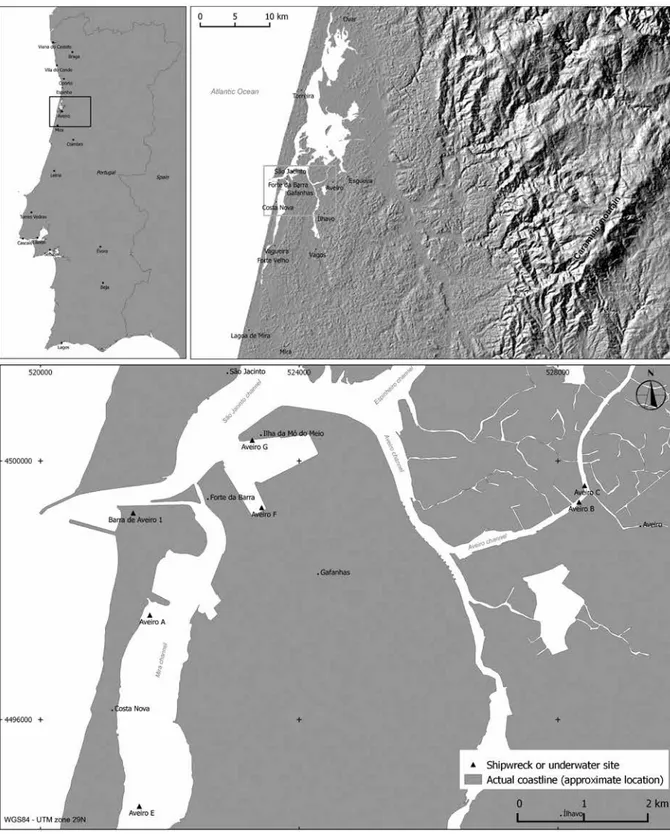
Geographic context
The Ria de Aveiro lagoon is located on the northern coast of Portugal, in the Aveiro region, between Porto and Coimbra. Its geomorphological evolution was one of the major constraints to navigation over the centuries. The formation of the lagoon was a rather quick process, which started around the 10th century, with the development of a sandbank, rooted in the Espinho
area. Around the 10th century, the Aveiro region featured an open coast, with consi derable
ex-posure to the sea. By the 12th century, the sandbank was located north of Torreira and in the
15th century it reached the São Jacinto area. In the 18th century, the sand barrier arrived at Mira,
completing the lagoon formation process (Corrochano et alii, 1999; 2000) (Fig. 1).
370
Patrícia Carvalho, José Bettencourt, Inês CoelhoIKUWA V | Págs. 368-378
maps. In fact, a quick analysis of 1759 cartography shows a desert landscape in this area, with the exception of an area around Forte Novo that represents cultivated land and salt production areas (Amorim, 2008c: 44-46). In spite of this development, dispersed settlement patterns remained during the 19th century. Population concentrations only appeared in the
20th century.
371
The maritime cultural landscape of the Ria de Aveiro lagoon (Portugal) in the Early Modern period:...
IKUWA V | Págs. 368-378
The lagoon as an economic space
The lagoon also influenced the life of the populations, which combined agricultural activities with salt production, collecting moliço (a seaweed) and fishing. These economic activities, often seasonal and complementary, marked the lagoon’s landscape. In fact, several maps show the salt production locations in the lagoon, such as the Lucas Waghenaer («Die zee caerte van Portugal; tusschen Camino en Montego...» c.1583) and Willem Blaeu («De Zeecosten van Portugal van Via-na tot Aveiro», c.1638) maps or the 1634 «Atlas» by Pedro Teixeira de AlberVia-naz (Amorim, 2008b: 39, 43).
The traditional solar salt production in the lagoon is well known and documented since the 10th century (Silva, 1991; Amorim, 2008a). This economic activity was the result of the
favo-rable landscape and environmental conditions, like the vast extension of wetlands and the constant salinity levels in the lagoon water, which originated a salt production increase from the 13th century onwards (Rau, 1984). Actually, the Aveiro region played an important role in
supplying salt –fundamental for fish preservation– to Northwestern Europe since the Middle Ages. During the 16th and 17th centuries, Aveiro also supplied the north of Spain, in particular
Galicia and Asturias, as well as the Dutch market, especially after 1640 (Amorim, 2008a; An-tunes, 2008).
Besides salt, the moliço was also a very important resource of the lagoon area. In the 18th
century, this seaweed was collected by the populations and used as a natural soil fertilizer (DGARQ/TT, «Memórias Paroquiais», 1758, Ovar). The importance of this activity led to the de-velopment of a particular type of boat, called moliceiro, used until the 20th century and recently
adapted to support touristic activities in the lagoon (Castro, 1943).
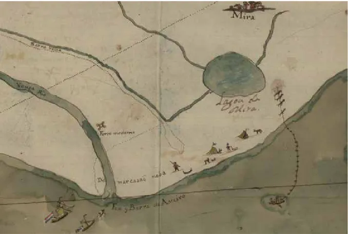
Fishing was also a resource used by these riverside villages, although in a complementa-ry and seasonal manner. Evidence related to this activity is scarce; nevertheless, there are some references to the species and the fishing methods utilized in the lagoon. In the 18th century, the
Figure 2. Detail of the 18th century map (Pinto, 2011; Arquivo Nacional Torre do Tombo) representing a type of coastal fishing
372
Patrícia Carvalho, José Bettencourt, Inês CoelhoIKUWA V | Págs. 368-378
most common species were eel, dab, flounder and mullet (DGARQ/TT, «Memórias Paroquiais», 1758; Aveiro and Ovar) and there is an 18th century map, recently discovered and published by
a Portuguese colleague, that represents a type of coastal fishing (Pinto, 2011). This fishing tech-nique used a type of seine net dragged by a small vessel to surround a certain area (Fig. 2). The net was then operated from the shore by the fishermen, thus bringing the fish to the beach (about fishing in Aveiro in the 18th century see, for example, Amorim, 1997).
373
The maritime cultural landscape of the Ria de Aveiro lagoon (Portugal) in the Early Modern period:...
IKUWA V | Págs. 368-378
The seasonal nature of this activity led to the creation of seasonal coastal occupa-tions, represented by tents in that 18th century map (Fig. 2). Their most recent parallels are
a sort of seasonal housing (the so-called palheiros) used by the fishermen, which existed in the areas of Costa Nova, Vagueira or around Mira, in places located on the sand barrier that separates the lagoon from the sea. These costal occupations are mentioned in early 20th
cen-tury cartography and literature and were also the subject of anthropological studies, since they started to disappear by the end of the 20th century (Direcção Geral dos Trabalhos
Geodésicos e Topográficos, Carta de Portugal 1/50000, sheets 9-C e 10-C; Brandão, 2010; Brito, 1981).
The importance of fishing to the communities in this region wasn’t limited to the area inside or around the lagoon, it actually reached a wider area in the Atlantic. Indeed, in the 16th century the Aveiro fleet counted 72 ships, some of them involved in the cod fisheries of
Newfoundland. On the other hand, 17th century written sources mention fishing as a major
occupation of the seamen from Aveiro and Esgueira villages (DGARQ/TT, CC, p. I, mç. 115, n.º 17).
The Aveiro region as an Atlantic port
Navigation dynamics are also documented by archaeological remains that have been recorded in the lagoon area since 1970, either on land or underwater, such as the remains of a ship disco-vered in 1973, near the Barra lighthouse (Bettencourt, 2009).
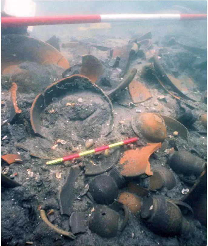
This discovery was followed by the Ria de Aveiro A wreck site, discovered in 1992. This is a small Iberian-Atlantic tradition ship of the early modern period featuring a large earthenware cargo from the Aveiro-Ovar region (Fig. 3). Its discovery was a starting point to review the dis-tribution of Aveiro earthenware (Bettencourt/Carvalho, 2007-2008; Carvalho/Bettencourt, 2012). Similar ceramics were found in Portugal, particularly in the North (Viana do Castelo, Porto, Co-imbra), but also in the Atlantic, in places like Newfoundland, or in contexts related to seasonal fishing settlements (Alves et alii, 2001; Bettencourt/Carvalho, 2007-2008; Carvalho/Bettencourt, 2012; Newstead, 2012).
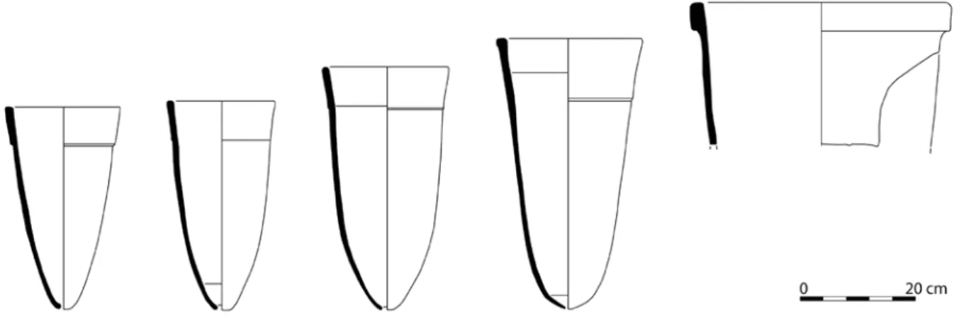
The same type of ceramics was also recovered from the Ria de Aveiro E shipwreck site, found in 1999 (Bettencourt, 2009), and from the Ria de Aveiro B/C site, where numerous sugar molds were recovered on a waterway located close to the city (Coelho, 2012) (Fig. 4).
374
Patrícia Carvalho, José Bettencourt, Inês CoelhoIKUWA V | Págs. 368-378
This Aveiro ceramic production was particularly important. Written sources suggest the important role of the region in the manufacture of industrial ceramics, providing large amounts of sugar molds for the Madeira Islands and for the Canary mills. For example, during the second half of the 16th century more than 13 000 sugar molds were imported from Aveiro into the Canary
Islands; they were considered solid, good quality ware (Lobo, 1987: 8-11). They are common in sugar mill archaeological sites, and were identified in Gran Canaria Island, at the «Las Candela-rias» mill and also on Madeira and Azores Islands (Sousa, 2012: 216: Coelho, 2012).
The Atlantic dimension of the Aveiro navigation is also documented by the remains of the Ria de Aveiro F ship, discovered in 2002 during dredging works in Aveiro harbor. Recent analyses of the timbers suggest that this vessel, built in the first half of the 16th century and incorporating
some Mediterranean shipbuilding techniques, used tropical woods in its construction. Thus, it may constitute an evidence of shipbuilding or naval repairs taking place in colonial spaces (Bet-tencourt, 2009; Lopes, 2013).
Furthermore, the Aveiro B/C finds included a huge assemblage of Aveiro ceramics, but also several artifacts related to maritime activities, such as an astrolabe, inscribed with the date of 1575, or a nautical blow whistle. The ceramic assemblage includes some items from the Me-diterranean and Northern Europe, such as Portuguese faience, olive jars, stoneware and kaolin pipes. Recovered from a port area and disturbed by dredging works carried out during the se-cond half of the 20th century, these findings place Aveiro in the routes connecting the North and
the South of Europe since the Middle Ages (Bettencourt, 2009; Coelho, 2012).
Finally, the Ria de Aveiro G clinker-hull ship, discovered during the port extension works and dated between the 13th and the 14th centuries, has some features that are typical of Northwest
European shipbuilding. Therefore, it may constitute direct evidence for the relations with that region, namely the Bay of Biscay, where similar construction features were documented in the Guernika ship, dated from the 15th century (Bettencourt, 2009).
Navigation and access to the lagoon
Returning to the analysis of the lagoon, the distribution of these sites indicates that the wrecks have occurred in areas of access to Aveiro city. That distribution becomes even more signifi-cant if one considers its chronology: the oldest sites, Ria de Aveiro F and G, are located in the area that gave access to the lagoon entrance c. 1500, whereas the Ria de Aveiro A site is loca-ted in the Mira channel, which was the access to the lagoon during those centuries. Actually, the entrance was gradually displaced towards the South between the late-16th and the 18th
centuries.
Exception is made to the ship located at the Barra Hotel (Barra de Aveiro 1), as its chronology remains undefined due to the lack of archaeological data. Nevertheless, the authors think that she should have lied outside the lagoon until the 19th century, when the entrance was
artificially opened. Actually, navigation has been significantly conditioned by the morphosedi-mentary changes of the lagoon system.
These changes required the use of landscape marks as navigation aids. Viewed from the sea, the position of the entrance was marked by the Caramulo Mountain, which reaches a ma-ximum height of some 1077 meters (Fig. 1).
land-375
The maritime cultural landscape of the Ria de Aveiro lagoon (Portugal) in the Early Modern period:...
IKUWA V | Págs. 368-378
scape marks. Two of them are documented inside the lagoon: the Old Fort (Forte Velho) and the New Fort (Forte da Barra).
The Old Fort, in Vagueira, is represented in 18th and 19th century cartography and was a
reference point for navigation because it marked the position of the lagoon entrance, which was located either to the north or to the south of this structure, between 1643 and 1838 (Cunha, 1959: 27).
This is shown on a 1764 drawing by the Dutch consul in Aveiro, which indicates that it would be demolished, as well as on a 1759 French survey and a 1778 chart (copied in 1876) (Amorim, 2008c: 44-45, 47, 128-129). The same name appears on an 18th century map, in the
Gafanha side, opposite to S. Jacinto and next to the «Most Ancient entrance of 1500» («Barra An-tiquíssima do Anno 1500»). It remains linked to that area until the 20th century, on the island of
Mó do Meio, which might indicate the existence of an older fortification there (Pinto, 2011; IG-eoE, col. Continente, series M888, sheet 184). In fact, in the early-19th century, the person
respon-sible for the construction works at the lagoon entrance refers the finding of a headstone with the year 1643 inscribed on it (Amorim, 2000: 616).
The New Fort, which appears in the same cartography as the old one, is supposed to be unfinished in the 1764 drawing; this was a major concern for the local authorities in 1759. Be-sides the lack of surveillance conditions, they also lacked the means to acquire vessels to control and guide ships entering the lagoon (Amorim, 2008c: 117). This military structure was located right at the new entrance, opened in 1808, at the confluence of the Mira and S. Jacinto channels. Today, part of this structure still stands and is called Forte da Barra.
Another important navigation landscape mark was the chapel of Senhora dos Navegantes in S. Jacinto, along with the nearby signal station (facho in Portuguese). According to a 1584 document, these structures replaced an old, ruined watchtower in the Aveiro entrance (Cunha, 1959: 7).
This chapel often appears in the cartography from the end of the 16th century onwards.
In the representation of the coast of Portugal by Lucas Waghenaer (c.1583) and despite some inconsistencies, a religious building appears on the sand spit; the authors assume that it might be that chapel. The Pedro Teixeira de Albernaz’s representation displays a religious building in the same area. Moreover, this map is particularly interesting because it shows a structure near the chapel, which might correspond to a signal station using flags to assist the entry of vessels, as, for instance, in the case of the «Facho» of Mount Brazil, in the Azores, represented by Jan Huygen van Linschoten in the 16th century.
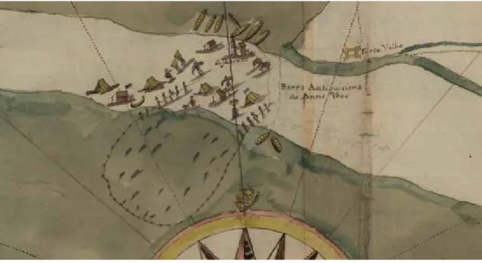
The references to signal stations are also confirmed by written sources: the existence of a vessel that should watch the lagoon entrance and use flags to guide the ships is referred in 1641 (Aguilar/Meneses, 1640-1641). In fact, the 18th century drawing (Pinto, 2011) shows a small
vessel towing a larger one on the lagoon entrance, and if one looks carefully it is possible to see another ship with a flag at the entrance. It might not be related to the signal station aboard the ship, but it still is interesting to notice (Fig. 5).
The same source mentions the existence of three masts that should provide the right alignment to enter the lagoon. These marks already appeared in the Lucas Waghenaer map by the end of the 16th century (c.1583) but are more clearly represented in the 1648 map by João
376
Patrícia Carvalho, José Bettencourt, Inês CoelhoIKUWA V | Págs. 368-378
Concluding remarks
This approach to the maritime cultural landscape of Ria de Aveiro points out the diversity and complexity of the study subjects: the evolution of the lagoon, the human settlement, the mari-time economy and the port operation are just some examples. It also reveals the international expression of the maritime cultural heritage of this region, as a starting point for the analysis of the relationships between the Atlantic and Northern and Southern Europe.
The study requires information resulting from archaeological work, from written and iconographic sources or from anthropological studies, applying different methods of analysis that must also be interdisciplinary. However, this line of research is essential to establish the cultural framing of the underwater archaeological sites discovered in the last decades. Further-more, it and can also be an important tool to assess the lagoon’s maritime heritage.
References
AGUILAR, M. C., and MENESES, J. (1640-1641): Advertência de Navegantes. DGARQ/TT.
ALVES, F. et alii (2001): «The hull remains of Ria de Aveiro A: a mid-15th century shipwreck from Por-tugal: a preliminary analysis».In International Symposium on Archaeology of Medieval and Modern Ships of Iberian-Atlantic Tradition: proceedings. Hull remains, manuscripts and
eth-nographic sources: a comparative approach. Edited by ALVES, F. J. S., and RODRIGUES, P. J. P.,
Lisboa, Instituto Português de Arqueologia, pp. 317-345. (Trabalhos de Arqueologia, vol. 18). Figure 5. Detail of the 18th century map (Pinto, 2011; Arquivo Nacional Torre do Tombo) representing a small vessel towing a
377
The maritime cultural landscape of the Ria de Aveiro lagoon (Portugal) in the Early Modern period:...
IKUWA V | Págs. 368-378 AMORIM, I. (1997): «A estrutura das “Artes Novas” da costa de Aveiro, ao longo da 2.ª metade do sécu-lo XVIII: mão-de-obra, divisão de trabalho, formas de propriedade e divisão do produto». In
Antropoloxía Mariñeira, Actas do Simposio Internacional in memoriam Xosé Filgueira
Valverde. Pontevedra, Consello de la Cultura Galega, pp. 159-185.
— (2000): «Urbanismo e cidades portuárias: Aveiro na segunda metade do século XVIII». In
Análise Social, vol. XXXV, n.º 156, pp. 605-650.
— (coord.). (2008a): A articulação do sal português aos circuitos mundiais: antigos e novos
consumos. Porto, Universidade do Porto, Instituto de História Moderna.
— (2008b): «Monopólio e concorrência: a “roda do sal” de Setúbal (Portugal) e as rotas inter-nacionais (segunda metade do século XVII a inícios do de XIX)». In A articulação do sal
português aos circuitos mundiais: antigos e novos consumos. Edited by AMORIM, I., Porto,
Universidade do Porto, Instituto de História Moderna, pp. 183-209.
— (2008c): Porto de Aveiro: entre a terra e o mar. Aveiro, Administração do Porto de Aveiro.
ANTUNES, C. (2008): «The commercial relationship between Amsterdam and the Portuguese salt-ex-porting ports: Aveiro and Setubal, 1580-1715». In A articulação do sal português aos circuitos
mundiais: antigos e novos consumos. Edited by AMORIM, I., Porto, Universidade do Porto,
In-stituto de História Moderna, pp. 161-182.
BETTENCOURT, J., and CARVALHO, P. (2007-2008): «A carga do navio Ria de Aveiro (Ílhavo, Portugal): uma aproximação preliminar ao seu significado histórico-cultural». In Cuadernos de Estudios
Bor-janos, vol. L-LI, pp. 257-287.
BETTENCOURT, J. (2009): «Arqueologia marítima da Ria de Aveiro: uma revisão dos dados disponíveis».
In Octávio de Lixa Filgueiras, Arquitecto de Culturas Marítimas. Edited by ALVES, F., and GAR
-RIDO, A., Lisboa, Âncora Editora, pp. 165-188.
BETTENCOURT, J. et alii (2013): Relatório do registo e avaliação dos navios Boavista 1 e Boavista 2,
de-scobertos durante a construção da Nova Sede Corporativa do Grupo Edp (Avenida 24 de
Jul-ho, Lisboa). Lisboa, CHAM.
BRANDÃO, R. (2010): Os pescadores. Porto, Estante Editora.
BRITO, R. S. (1981): Palheiros de Mira: formação e declínio de um aglomerado de pescadores. Lisboa, INIC, Centro de Estudos Geográficos da Universidade de Lisboa.
CASTRO, D. J. (1943): Os Moliceiros, estudos etnográficos. Instituto Português para a Alta Cultura.
CASTRO, F. (2005): «Arade River Archaeological Complex: Dredges and Archaeology». In The
Interna-tional Journal of Nautical Archaeology, vol. 34, n.º 1, pp. 51-61.
CARVALHO, P., and BETTENCOURT, J. (2012): «De Aveiro para as margens do Atlântico: a carga do navio Ria de Aveiro A e a circulação de cerâmica na época moderna». In Velhos e Novos Mundos.
Estudos de Arqueologia Moderna. Edited by TEIXEIRA, A., and BETTENCOURT, J., vol. II, Lisboa,
CHAM, pp. 733-746.
COELHO, I. (2012): «Muito mais do que lixo: a cerâmica do sítio arqueológico subaquático Ria de Aveiro B-C». In Velhos e Novos Mundos. Estudos de Arqueologia Moderna. Edited by TEIXEIRA, A., and BETTENCOURT, J., vol. II, Lisboa, CHAM, pp. 757-770.
378
Patrícia Carvalho, José Bettencourt, Inês CoelhoIKUWA V | Págs. 368-378
— (2000): «Los sedimentos del canal mareal de Mira (Aveiro, Portugal): propiedades textura-les, procedencia y modelo paleogeográfico». In Stvdia Geologica Salmanticensia, n.º 36, pp. 143-160.
CUNHA, S. (1959): O Porto de Aveiro: conferência realizada a 5 de Maio de 1923 na sede da
Asso-ciação dos Engenheiros Civis Portugueses. Aveiro, Tipografia «A Lusitânia».
LOBO CABRERA, M. (1987): «El comercio entre Portugal y Canarias en el Quinientos. Estudio aproxima-do». In Revista de Historia Económica e Social, n.º 19, pp. 1-16.
LOPES, G. C. (2013): Ria de Aveiro F (Ílhavo): um naufrágio de época moderna na laguna de Aveiro. Universidade Nova de Lisboa, Faculdade de Ciências Socias e Humanas, Master thesis in Ar-chaeology. [Online]. Available at: http://hdl.handle.net/10362/11364. [Accessed: February, 2015].
LOUREIRO, V. (2011): L’épave Arade l. L’influence des chantiers régionaux sur la tradition de
construc-tion navale ibéro-atlantique. Université de Paris 1-Pantheon-Sorbonne, Thèse de doctorat en
Archéologie.
Memórias Paroquiais (1758): Aveiro e Ovar. DGARQ/TT.
NEWSTEAD, S. (2012): «Portuguese coarseware in Newfoundland, Canada». In Velhos e Novos Mundos.
Estudos de Arqueologia Moderna. Edited by TEIXEIRA, A.,and BETTENCOURT, J., vol. II, Lisboa,
CHAM, pp. 747-756.
PINTO, P. (2011): «A importância do fundo dos Feitos Findos na Torre do Tombo para a história local: o caso de Aveiro». In Patrimónios, n.º 9, ano XXXI, 2.ª série, pp. 187-196.
RAU, V. (1984): Estudos sobre a história do sal. Lisboa: Presença.
RODRIGUES, P. et alii (2001): «L’épave d’un navire de la deuxième moitié du XVème siècle/début du XVIème, trouvée au Cais do Sodré (Lisbonne). Note préliminaire». In International Symposium
on Archaeology of Medieval and Modern Ships of Iberian-Atlantic Tradition: proceedings. Hull
remains, manuscripts and ethnographic sources: a comparative approach. Edited by ALVES, F.
J. S., and RODRIGUES, P. J. P., Lisboa, Instituto Português de Arqueologia, pp. 347-380. (Tra-balhos de Arqueologia, vol. 18).
SILVA, M. J. (1991): Aveiro Medieval. Aveiro, Câmara Municipal.
SOUSA, É. (2012): Ilhas de Arqueologia. O Quotidiano e a Civilização Material na Madeira e nos
Açores (Séculos XV-XVIII). Faculdadede Letras da Universidade de Lisboa, Doctoral thesis in
History-Regional and Local History. 2 vols.
WESTERDAHL, K. (1992): «The maritime cultural landscape». In The International Journal of Nautical