Department of Information Science and Technology
Parking Guiding System with
Occupation Prediction
Gonçalo Pereira Alface
A Dissertation presented in partial fulfillment of the Requirements
for the Degree of
Master in Computer Engineering
Supervisor
PhD. Professor João Carlos Ferreira, Assistant Professor
ISCTE-IUL
Co-Supervisor
PhD. Professor Rúben Filipe Pereira, Assistant Professor
ISCTE-IUL
A disponibilidade de estacionamento é um recurso cada vez mais escasso e caro nas grandes cidades, e este problema é considerado um dos mais críticos nos sis-temas de gestão de transportes dentro de uma grande cidade. Para abordar este problema, uma prova de conceito é apresentada como uma forma de guiar um condutor para o parque de estacionamento com lugares disponíveis através de um processo de previsão usando dados passados, correlacionados com o tráfego, condições climáticas e características do período de tempo (ano, mês, dia, feriados, e assim por diante).
Uma seleção de características foi realizada pelo estudo de padrões de dados, a fim de entender a afluência do estacionamento e como certas características os in-fluenciam, bem como para compreender as mudanças repentinas na ocupação total do estacionamento e quais características realmente importam e têm um impacto sobre a ocupação total. Essas conclusões ajudaram a criar um modelo preditivo robusto e eficiente a fim de prever a taxa de disponibilidade do estacionamento com mais precisão.
Três algoritmos foram usados para construir os modelos preditivos como forma de testar o mais eficiente e preciso, a saber: Gradient Boosting Machine, Decision Random Forest e Neural Networks. Foram também testados vários tipos de mod-elos com o objetivo de melhorar os resultados obtidos, bem como compreender o impacto de cada um dos processamentos de dados utilizados.
Para complementar, foi criado um algoritmo de decisão para orientar o con-dutor para o parque de estacionamento mais indicado e que apresente melhores condições, tendo em conta a localização e as características do condutor, como o mais provável de ter um lugar de estacionamento disponível, mais próximo da posição atual do utilizador ou um preço mais atrativo para o condutor. Final-mente, estes desenvolvimentos são integrados numa aplicação móvel de forma a que o utilizador consiga aceder através de uma interface.
Palavras-chave: disponibilidade de estacionamento, previsão, apli-cação móvel, probabilidade, gestão de estacionamento
Parking availability is an increasingly scarce and expensive resource within large cities, and this problem is considered to be one of the most critical transportation management system inside a big city. To approach this problem a proof of concept is presented as a way to guide a driver to the possible free parking lot through a prediction process using past data, correlated with traffic, weather conditions and time period features (year, month, day, holidays, and so on).
A feature selection was performed by the study of data patterns, in order to understand the parking lot affluence and how certain features influence them, as well as to comprehend the sudden changes in the total occupation of the parking lot and which features really matter and have an impact on the total occupation. Those conclusions helped to create a robust and efficient predictive model in order to predict the parking lot availability rate more accurately.
Three algorithms were used to build the predictive models as a way to test the most efficient and accurate one, namely Gradient Boosting Machine, Decision Random Forest and Neural Networks. Various types of models were tested with the aim of improving the results obtained, as well as understanding the impact of each of the processing of the data used.
To complement this, a decision algorithm was created to guide the driver to the most optimal parking lot that presents better conditions, taking into account the location and driver characteristics, like the park more likely to have an available parking space, closer to the user’s current position or a more attractive price for the driver. Finally, these developments are integrated into a mobile application in order to work like an interface that the driver can interact.
Keywords: parking availability, prediction, mobile app, probability, parking management
I would like to express a big thanks to my supervisors, Professor João Carlos Ferreira and Professor Rúben Pereira, for their guidance, support and feedback, as well as encouraging me to take this opportunity.
A special and huge thanks to my family, for educating and motivating me to achieve better and higher goals and for believing in me wholeheartedly. To my girlfriend, Mariana, for being the most generous, loving and understanding person ever and for believing in me, more than I do myself. And lastly, to my friends for the encouragement, the laughs and for helping me to keep my sanity. Once again, thank you all for the encouragement, for believing and for the unconditional support and love. None of this would be possible without them.
Resumo iii
Abstract v
Acknowledgements vii
List of Figures xiii
Abbreviations xvii
1 Introduction 1
1.1 Motivation and Overview. . . 1
1.2 Objectives . . . 6
1.3 Research Method . . . 7
1.4 Research Structure . . . 9
2 Literature Review 11 2.1 Systems for Parking Availability . . . 11
2.2 Feature Selection for Parking Availability Forecast . . . 15
2.3 Forecasting Parking Availability Techniques . . . 19
3 Conceptual Model of Park Aid App 27 3.1 Final Dataset . . . 28
3.2 Predictive Model . . . 29
3.3 Decision Algorithm . . . 30
3.4 Park Aid Android Application . . . 30
4 Feature Selection 33 4.1 Data Description . . . 34
4.1.1 Parking lot data. . . 34
4.1.2 Weather data . . . 36
4.1.3 Traffic data . . . 37
4.2 Data Processing . . . 38
4.3 Data Evaluation. . . 42
4.3.1 Over Time Occupation . . . 43
4.3.2.1 Events for Park 1 . . . 45
4.3.2.2 Invalid Measurements for Park 1 . . . 47
4.3.2.3 Events for Park 2 . . . 47
4.3.2.4 Invalid Measurements for Park 2 . . . 48
4.3.2.5 Events for Park 3 . . . 48
4.3.2.6 Invalid Measurements for Park 3 . . . 49
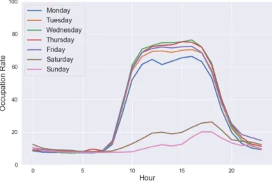
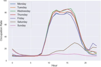
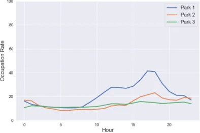
4.3.3 Occupation rates throughout the week . . . 50
4.3.3.1 Park 1 . . . 50
4.3.3.2 Park 2 . . . 51
4.3.3.3 Park 3 . . . 52
4.3.4 Holidays . . . 52
4.3.5 Vacation Period . . . 55
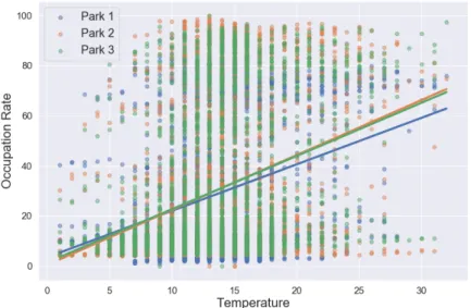
4.3.6 Park Occupancy and Weather Data . . . 57
4.3.6.1 Temperature Correlation with Occupation Rate . . 57
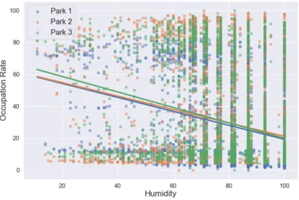
4.3.6.2 Humidity Correlation with Occupation Rate . . . . 58
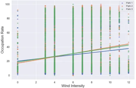
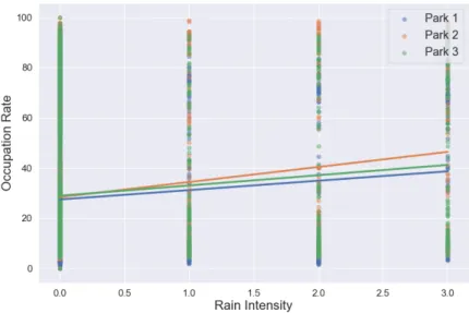
4.3.6.3 Wind Intensity Correlation with Occupation Rate . 59 4.3.6.4 Rain Intensity Correlation with Occupation Rate . 61 4.3.6.5 Rain versus No rain . . . 62
4.3.6.6 Fog versus No fog. . . 63
4.3.7 Park Occupancy and Traffic Data . . . 66
4.3.7.1 Park 1 . . . 66
4.3.7.2 Park 2 . . . 67
4.3.7.3 Park 3 . . . 68
4.4 Data Treatment . . . 69
4.5 Data Selection. . . 70
5 Predictive Model Development 71 5.1 Chosen Algorithms . . . 71
5.1.1 Gradient Boosting Machine (GBM) . . . 72
5.1.2 Distributed Random Forest (DRF) . . . 72
5.1.3 Neural Networks (NN) . . . 72
5.2 Prediction Models Preparation. . . 73
5.3 Predictive Model Testing . . . 77
5.3.1 Model with full dataset . . . 77
5.3.2 Model without context data . . . 78
5.3.3 Model without December data . . . 79
5.3.4 Model by month . . . 79
5.3.5 Model by day of the week . . . 80
5.3.6 Comparing results . . . 82
5.4 Optimization of the Predictive Model . . . 83
6 Decision Algorithm Development 85 7 System Demonstration 89 7.1 Example A: Parking lot availability . . . 90
7.2 Example B: Electric charging station availability . . . 92
8 Conclusions and Future Work 95 8.1 Conclusions . . . 95
8.2 Future Work . . . 97
References 99 Appendices 105 Appendices 107 A Weather main and weather description values possibilities. . . 107
B Park 1 Occupancy Overtime . . . 107
C Park 2 Occupancy Overtime . . . 109
D Park 3 Occupancy Overtime . . . 111
E Park 1 Occupancy correlation with Traffic Data . . . 113
F Park 2 Occupancy correlation with Traffic Data . . . 114
G Park 3 Occupancy correlation with Traffic Data . . . 115
1.1 Research Methodology Diagram.. . . 8
3.1 Conceptual Model Diagram . . . 28
3.2 Park Aid application menu. . . 31
3.3 Parking lots location on the map. . . 32
3.4 Pop-up information board on a parking lot. . . 32
4.1 Feature Selection Process. . . 34
4.2 Average occupation rate for Park 1 on the various weekdays. . . 51
4.3 Average occupation rate for Park 2 on the various weekdays. . . 51
4.4 Average occupation rate for Park 3 on the various weekdays. . . 52
4.5 Average occupation rate on a Holiday of value 0 importance. . . 53
4.6 Average occupation rate on a Holiday of value 1 importance. . . 53
4.7 Average occupation rate on a Holiday of value 2 importance. . . 54
4.8 Average occupation rate during the non vacation period. . . 55
4.9 Average occupation rate during the vacation period. . . 56
4.10 Correlation between the temperature feature and the occupation rate from the parks.. . . 57
4.11 Correlation between the humidity feature and the occupation rate from the parks. . . 58
4.12 Correlation between the wind intensity feature and the occupation rate from the parks.. . . 60
4.13 Correlation between the rain intensity feature and the occupation rate from the parks.. . . 61
4.14 Average occupation rate for a day without rain. . . 62
4.15 Average occupation rate for a day with rain. . . 63
4.16 Average occupation rate for a day without fog. . . 64
4.17 Average occupation rate for a day with fog. . . 65
5.1 Histogram values for the occupation rate from Park 1.. . . 74
5.2 Histogram values for the tax occupation from Park 2. . . 74
5.3 Histogram values for the tax occupation from Park 3. . . 75
5.4 Confusion Matrix example.. . . 77
7.1 The route to the Park 1 selected by the decision algorithm. . . 92
8.1 Park 1 Occupation during the month of October. . . 107
8.2 Park 1 Occupation during the month of November. . . 108
8.3 Park 1 Occupation during the month of December. . . 108
8.4 Park 1 Occupation during the month of January. . . 109
8.5 Park 2 Occupation during the month of October. . . 109
8.6 Park 2 Occupation during the month of November. . . 110
8.7 Park 2 Occupation during the month of December. . . 110
8.8 Park 2 Occupation during the month of January. . . 111
8.9 Park 3 Occupation during the month of October. . . 111
8.10 Park 3 Occupation during the month of November. . . 112
8.11 Park 3 Occupation during the month of December. . . 112
8.12 Park 3 Occupation during the month of January. . . 113
8.13 Correlation between the average time to travel the road segments close to the Park 1 and the occupation rate from the Park 1. . . 113
8.14 Correlation between the average time to travel the road segments close to the Park 1 and the occupation rate from the Park 2. . . 114
8.15 Correlation between the average time to travel the road segments close to the Park 3 and the occupation rate from the Park 3. . . 115
2.1 Studies comparison using different data sources. . . 15
2.2 Studies results about the features that influence parking availability. 18 2.3 Studies results about the different prediction techniques used for parking availability. . . 26
4.1 Parking prices for the 3 parking lots being analyzed.. . . 35
4.2 Columns used from the weather data. . . 37
4.3 Columns used from the traffic data. . . 38
4.4 Public holidays used for the analysis. . . 40
4.5 Wind speed categorization following the Beaufort Scale. . . 41
4.6 Correlation results of the temp feature with the occupation rate. . . 58
4.7 Correlation results of the humidity feature with the occupation rate. 59 4.8 Correlation results of the wind_intensity feature with the occupa-tion rate.. . . 60
4.9 Correlation results of the rain_intensity feature with the occupation rate. . . 61
4.10 Correlation results of the average_time features for the surrounding roads of the Park 1 with the occupation rate.. . . 66
4.12 Correlation results of the average_time features for the surrounding roads of the Park 3 with the occupation rate.. . . 68
5.1 Accuracy and mean execution time results for the full-data model. . 78
5.2 Accuracy and mean execution time results for the model without context data. . . 78
5.3 Accuracy and mean execution time results for the model without December data. . . 79
5.4 Accuracy and mean execution time results for the models divided by month. . . 80
5.5 Accuracy and mean execution time results for the models divided by day of the week. . . 81
5.6 Models results after optimizing the parameters. . . 84
7.1 Decision algorithm heuristics and weight result outcomes for the three parking lots. . . 91
7.2 Decision algorithm heuristics and weight outcomes for the three charging stations. . . 93
8.1 Weather main and weather description values possibilities. . . 107
8.2 Confusion Matrix of the Optimized Model built with Park 1 data. . 115
8.3 Confusion Matrix of the Optimized Model built with Park 2 data. . 116
PGIS Parking Guidance and Information System IPR Intelligent Parking Reservation
CRISP-DM Cross-Industry Standard Process for Data Mining IoT Internet of Things
SVR Support Vector Regression RMSE Root Mean Square Error NN Neural Networks
API Application Programming Interface DR Duration of the Route
DPD Distance from the Parking lot to the final Destination PPH Price Per Hour
AR Availability Rate
JSON JavaScript Object Notation CSV Comma-Separated Values DRF Distributed Random Forest GBM Gradient Boosting Machine
TP True Positive TN False Negative FP False Positive FN False Negative
MOJO Model ObJect, Optimized
ISCTE-IUL Instituto Superior de Ciências do Trabalho e da Empresa - Instituto Universitário de Lisboa
Introduction
In this chapter the scope of this work is introduced by giving some context and motivation, as well as the objectives and the methodology used. At the end of the chapter the structure of the document is also introduced.
1.1
Motivation and Overview
Nowadays, if drivers want to leave home and go to a desired destination, they can use the vehicle’s navigation system or third party applications to find the destination with ease. Those systems give clear information about the time it takes to arrive to the destination, but upon reaching it the driver needs to find an available parking space which can take quite some time and effort (Klappenecker, Lee, & Welch, 2014). This phenomenon is intensified when people who do not know the city, such as tourists or non-residents, are looking for a parking space, as residents have a better knowledge of the place. We have all been in the situation of trying to locate a free parking space to park the car, and after minutes and minutes of searching, we start to get frustrated and our stress levels increase, making us angrier and therefore increasing the probability of making an error, possibly causing an accident (Ionita, Pomp, Cochez, Meisen, & Decker, 2018).
"Blind Search" (Shin & Jun, 2014) and is used by the drivers when there is no information given regarding the current status of the parking lot. This strategy is based on the driver going around the park looking for an empty parking space until they find a free one.
One of the major contributors to city traffic is the search for parking spaces (Bock, Martino, & Origlia, 2017), being responsible for 30% of the total traffic flow in dense urban scenarios (Shoup, 2006). Most of the time this increase is due to the drivers not having knowledge about where the parking lots are and if they have available parking spaces matching their expectations, forcing users to roam around. People looking for a free parking space often double park which is, by itself, an illegal activity (Giuffrè, Siniscalchi, & Tesoriere, 2012) or even resort to unauthorized spaces (Gantelet & Lefauconnier,2006) resulting in a major contribution to congestion on the roads, and other impacts like: increase the danger and probability of accidents involving pedestrians as cars block sight lines, since the drivers looking for a free parking space are more distracted and more stressed being more prone to cause accidents either with pedestrians or other vehicles (Ionita et al., 2018), degradation at the quality of public transportation, the time a driver wastes, increase of noise (Shin & Jun,2014), safety concerns for motorists and cyclists performing maneuvers around double-parked cars, increase of the pollution levels inside the city for up to 40% (Pflügler, Köhn, Schreieck, Wiesche, & Krcmar,2016) and unnecessary use of fuel (Klappenecker et al.,2014), increasing carbon emissions up to 27% and increase of 54% of time wasted in traffic (Giuffrè et al., 2012; Tayade & Patil, 2016).
Vehicles where initially invented to increase convenience and comfort in people’s every day life, however the demand for a parking space increases progressively over time, where a driver in the first 15 minutes of demand will look for an available spot within a distance of less than 200 metres from his final destination, but by exceeding 15 minutes of demand, this demand range increases, sometimes exceed-ing 500 metres (Gantelet & Lefauconnier,2006), this being a major inconvenience for drivers. Parking is becoming an expensive but also scarce resource being re-garded as one of the major issues in city transportation management since spatial
resource of a city is limited and the construction of new parking spaces is expen-sive, sometimes due to the public transport policy, in almost any major city in the world (Giuffrè et al.,2012). With the increase of the Smart Cities, which aim to make a city more efficient and improve the lives of its citizens, and that about 70% of the world population will start living in cities and surroundings by 2050 (Tayade & Patil, 2016), this is one of the major problems to tackle in the coming years (Chen, Pinelli, Sinn, Botea, & Calabrese, 2013).
A report on 4 districts in France (Gantelet & Lefauconnier, 2006) concluded that 64% of interviewed residential car owners have abandoned their trips for not finding an available parking space and estimated that 70 million hours are spent each year in France looking for parking spaces, resulting on a total of 700 million euros lost each year. Other study done on the parking situation in Schwabing (Germany) concluded that the annual total economy damage due to traffic caused by the search of an empty parking space had been estimated as much as 20 million euros (Caliskan, Barthels, Scheuermann, & Mauve,2007). On average, it takes 12 minutes for a driver to find a free parking place (Pflügler et al.,2016) and a nation-wide survey done in Netherlands says that if employer-provided and residential parking are excluded, a total of 30% of car trips end with the search for a free parking space (Bock & Sester, 2016). In the United States of America, a car looking for a free parking space in Los Angeles needs to go around a block at least two and a half times to find a clear space to park, adding a total of around 1,500,000 excess kilometers traveled, resulting on almost a total of 178,000 liters of gas wasted and a total of 730 tons of carbon dioxide produced in one year (Klappenecker et al., 2014).
It is important to define parking availability to be the remaining parking spaces in a parking lot, and as of what was said earlier, parking availability is among the most important factors affecting car-based trip decisions and traffic conditions in urban areas. Drivers’ decisions are influenced by past experience, as well as real-time (on road) perceptions (E. I. Vlahogianni, Kepaptsoglou, Tsetsos, & Karlaftis,
and so on) affects drivers’ parking decisions, just like the knowledge of current conditions (e.g. day of the week, if it is raining and how much, temperature, events around the parking spaces, and more) affects parking availability (Rong, Xu, Yan, & Ma, 2018). If the city has means to inform the drivers in advance about the availability of parking spaces at and around their intended destination, the traffic congestion can be efficiently controlled (Zheng, Rajasegarar, & Leckie,2015). The possibility of knowing the park availability in advance affects private car based trip decisions, since if a driver knows that he has a parking place available, he goes there or if there are no spaces available, he can rethink his route and go to another place with a space available, thus avoiding turning around and wasting time and fuel (E. I. Vlahogianni et al., 2016).
Services to mitigate the parking search problem and give parking information to the public has increased recently (Xiao, Lou, & Frisby, 2018). These systems can reduce the queues in front of parking lots and reduce the number of kilometres the driver travels, thus reducing the amount of fuel used and in turn reducing the amount of carbon sent to the atmosphere (E. I. Vlahogianni et al., 2016). One type of service is the Parking Guidance and Information System (PGIS), being an effective way to enhance city parking management, allowing the balance of vehicle parking in the different parking lots, where vehicles can be guided to an emptier parking lot, thus resulting in a better parking management (Z. Wang, Yi, Liu, & Zhang, 2007). Services like this can be very useful to resolve the problem users have while roaming around looking for an available parking space (Bock et al., 2017), but does need detailed real-time parking availability, usually collected by sensors, which sometimes prove quite expensive and hard to maintain, or by crowd-sensing solutions like mobile applications or probe vehicles, which are often difficult to obtain and small in quantity, not being able to have a complete real-time parking availability data (Bock & Sester, 2016), since the usage of roads is highly irregular where the main roads have a regular coverage, but secondary streets are not that often sensed. However, this type of systems do not take into account the time it takes to reach the parking lot, meaning that the current situation on the parking lot will not necessarily be the same upon reaching it (Caicedo, Blazquez,
& Miranda, 2012), which, in turn, can result in the problems that these systems are trying to solve.
Other services involve mobile payment, such as smartphone use, and call-ahead reservation services (Xiao et al., 2018), called Intelligent Parking Reservation (IPR), where the users can reserve a parking space at the final destination be-fore starting the trip. Those systems are able to interact with the navigation systems from the vehicles, as well as Internet users, giving access to real-time in-formation about the parking lot, as well as inin-formation on the characteristics of the park, from capacity, hourly price, location, etc. This information can then be shown in the PGIS or even in the IPR system, thus being able to guide drivers to a free parking space during their trips or before their departures, reducing the time spent parking, and in the case of theIPR, paying the fee in advance, avoiding queues (Caicedo et al., 2012). However, this call-ahead reservation could lead to high reservation costs, because the driver can get stuck in traffic or change his destination midway, having to pay even if the car is not inside the infrastructure. Predictive parking information reveals to be a very useful information tool for all drivers, as users will make informed choices, improving and optimizing parking searching in a way that people could start to plan their route depending on the availability of parking spaces at the destination upon reaching it. If systems based on the prediction of the parking occupancy are well managed and can produce accurate and real occupancy values then it can enhance the moment of decision for the users (Caicedo et al.,2012). According to (Caicedo, Robuste, & Pita,2006), users who have information about the availability rate of the parks have 45% more success in their decisions than those who do not have access to any information. The way to achieve parking availability foresight is a big challenge, as the system to be developed needs to generate precise parking availability values, because a system that underestimates free parking spaces will not forward the users to that parking lot and if the system returns more free parking spaces than there really are, it would forward a user to a parking lot with no free parking spaces, revealing a problem for the user and smear the confidence on the system (Richter, Martino, &
between the parking lots in an area, and how user behaviors affect the parking availability (Zheng et al., 2015).
Smart parking guidance based on the real-time information is still in its infancy, but considering that the parking problem is one of the most complicated issues in a big city and its limited availability can cause problems to the quality of life of people and the deterioration of urban mobility, it is important to improve the current parking guidance solutions and use them in an intelligent and more efficient way (Shin & Jun,2014). Road congestion, parking availability and more, are problems that with the help of smart cities, will be better dealt with, so a system like the one proposed in this study is more and more needed, where we need to create a parking availability prediction system that will help people plan their trips ahead of time, reducing traffic congestion and, therefore, save time and fuel and keep transport systems more efficient and roads safer.
1.2
Objectives
The present work tackles the increasing problem of parking availability inside big cities, by proposing a system to give accurate real-time advice and guidance in a mobile App about parking availability for drivers. This objective was divided into three sub-objectives to be better dealt with and can be viewed as follows:
• Objective 1: Identify the most important features to predict the parking availability in closed parks;
• Objective 2: Identify the most suitable predictive model;
• Objective 3: Develop a decision algorithm to choose the optimal park con-sidering several factors.
For the first objective there is a need to understand how the parking availabil-ity patterns occur throughout the days, so one of the focus in this research is to
understand the occupation patterns of a parking lot over time, and which external and internal park features most influence the occupation rate of a park. Under-standing all the elements that influence the parking lot occupancy allows us to create a more efficient and robust solution, so that cyclical and unexpected factors can be dealt with the best way possible.
The second objective focus on the development of prediction models by applying the best suitable predictive algorithm tested, measured by its performance time and precision capability. These algorithms would be fed with the occupation data of the parking lot and context information, concluded on the first objective, which can turn out to be a challenge, since those types of data are hard to find and originate from a number of different data sources which makes it harder to acquire and integrate.
Lastly, the third objective consists on the development of a decision algorithm that takes into consideration various heuristics with an associated weight factor and returns the most suitable parking lot that takes into consideration current user and park conditions. This way an overall system like the one proposed can help not only people who do not know the city to find a possible parking space, but also residents who do, by telling them what is the best parking option.
1.3
Research Method
This research work followed an adaptation of the Cross-Industry Standard Process for Data Mining (CRISP-DM) methodology. This methodology is an open stan-dard, robust and well-proven methodology, that provides a structured approach to planning a data mining project, as it can see in Figure 1.1 based on (Europe,
Figure 1.1: Research Methodology Diagram.
In the first step there is the Business Understanding and can be further ad-dressed in Chapter 1 and Chapter 2, where the needs of the business in question are analyzed. In the next step there is the Conceptual Model Design, seen in Chapter 3, where the proposed system is presented and is designed to be capable of dealing with availability problems. A brief description of each of the compo-nents developed is also addressed in this chapter. The next chapter, Chapter 4, the Feature Selection happens, where the description of each data source is made, as well as processing and treatment of the data. The data is then analyzed to try to understand which features are essential and helpful to the development of the system. Right after that, the Predictive Model Development phase occurs, seen in Chapter 5, where the data preparation and the testing of supervisioned algorithms is made, so the best predictive model can be created. After so, the Decision Algorithm Development starts, seen in Chapter 6, where this algorithm will be responsible of suggesting the most optimal parking lot for the driver to park. In the next step, Chapter 7, the System Demonstration is made so the overall functionality is shown.
1.4
Research Structure
This document is structured in 8 chapters, as it follows:
• In Chapter 2 a literature review of models developed when dealing with the prediction of parking availability is made, but there was also a focus on surveying the most influential factors in the allocation of the parking lot and current available parking systems;
• In Chapter 3 the conceptual model of the proposed system is presented and described for each component and how they work to deal with vehicle availability problems;
• Chapter 4 is where the feature selection is performed on all of the different data types used in this study. The data sources are described in depth, processed and treated, with the aim of integrating the various types of data. There is also a focus in the analysis of all the different types of data, in order to understand if they have an influence on the occupation of the parking lot. Finally, there is the conclusion which data is the most important for the occupation rate prediction;
• In Chapter 5 the development and testing of various predictive models is made by applying different algorithms to the data previously analyzed, with the aim of obtaining the best model to integrate in the system. Lastly, there is a focus on optimizing the predictive model in order to improve the results previously obtained;
• In Chapter 6 the definition and development of the decision algorithm is made;
• Chapter 7 focus on the demonstration of the proposed system;
• Lastly, Chapter 8 shows the conclusions reached at the end of the work, as well as some future work to improve the overall usability and performance
Literature Review
In this chapter we focus on what type of systems are already in use and imple-mented, which features show to be more important and have a bigger impact on the parking availability and the type of models created to deal with this type of problem.
2.1
Systems for Parking Availability
Systems studied and available for the help of parking availability are based on various types of data sources used when dealing with this type of problem, based on real-time parking data, on user data and on historical data (Pflügler et al.,
2016).
Systems based on real-time parking data can be equipped with Internet of Things (IoT) sensors. Real-time parking data is widely used and helpful in the prediction of park availability, as real-time parking information management could improve 10% of traffic in efficiency (Caicedo,2010). Those sensors are able to out-put real-time information about the parking lot, like which parking spaces are free or not (Shin & Jun,2014). The monitoring of each single parking space in parking lots is economically expensive, but in contrast it is quite feasible to monitor the
however the continuous IoT growth make it an increasing industry, resulting in lower costs for the sensors as well as more efficient and lower energy consumption (Zheng et al., 2015). Sensor information is produced at a large quantity and rate with huge heterogeneity, also known as Big Data, meaning that there is a necessity to apply efficient tools to analyze that data. A big disadvantage from this type of system is the cost of the equipment necessary for one single parking space, as well as the costs of maintenance (Rong et al., 2018). One big project involving park-ing sensors was SFpark, in San Francisco, uspark-ing a total of 8,622 parkpark-ing sensors, resulting on a total cost of 18 million US dollars (Richter et al., 2014).
Other systems based on real-time parking data use smart cameras capable of visual parking lot occupancy detection as we can see in (Amato et al.,2017), where this detection was based on a deep Convolutional Neural Network specifically de-signed for smart cameras. This systems can monitor more than one parking space at the same time, reducing the need to have sensors in every parking space and significantly reducing the costs of installing and maintaining the sensors. However, environmental conditions can greatly affect the performance of these systems, like shadows, light variations, partial occlusions of the image and weather conditions. The data from systems based on user data are provided directly by users, also called crowdsourcing. This type of information can be reported by users passing by as a way to contribute to the system efficiency, introducing the concept of Gamification. Users are encouraged to give information about free parking spaces at that current moment, and if that information is correct, they could be rewarded with discounts on parking spaces and other benefits. Disadvantages of this type of system are the need to have a large user base, so that the data that is produced is enough to generate sufficient data to provide adequate parking information. Also, the information veracity is not ensured, meaning that there is a need to implement methods to make sure that accuracy is met, adding extra processing (Pflügler et al., 2016). Crowdsourcing can be executed by numerous ways, e.g. mobile sensors installed in recent vehicles or even mobile applications on phones are an alternative to sense complete city districts (Bock & Sester,2016). Although, the crowd-sensing seems to be a good option from an economic perspective, its
coverage is almost always incomplete and user dependent, since roads used very little will have essentially no coverage (Bock & Sester, 2016).
There are also systems based on historical available data, cost-effective and not as dependent on a user base. This type of system, if it has enough data, can cover cyclical variations over a year (e.g. seasons of the year, holidays period, and so on) which may prove to be important (Tilahun & Di Marzo Serugendo, 2017). Having access to historical data is really important when dealing with this type of problems, being easier to monitor and retrieve data from closed parking lots than on-street parking. Even in the off-street parks with no control admission, the information needs to be registered and such can be done with sensors, but the installation and maintenance of those types of hardware is very costly to cover a large area (Amato et al., 2017). Another easier solution is, instead of monitoring each single parking space, monitor the flow of entering and leaving in the parking lot (Klappenecker et al., 2014), this way the park monitor will always have the exact number of cars in the parking lot at a reasonable cost. However, this type of monitoring will not be able to give the exact position of a free parking space and can only be implemented on closed parking lots. In (E. I. Vlahogianni et al.,
2016) six months of historical data was used, and in (Pflügler et al., 2016) only two months, revealing to be a short time to cover all possible outcomes and not showing the full impact of cyclic features like seasons of the year.
A critical problem with a data-driven prediction of a parking lot availability are the quality of the data used. Usually data from sensors shows a big amount of noise and variability and invalidation’s (Bock et al., 2017), like missing values or incongruities, making the accuracy of the prediction worse, as it is harder to train a generalized model and harder to predict correct values (Richter et al., 2014).
Systems have been implemented to overcome the difficulty of finding a free park-ing space, namely the PGIS, that offer the driver information about the current state of the parking lot, like the free parking spaces. In (Grodi & Rios-gutierrez,
2016) a prototype of smart parking system using wireless sensor technology and networks, that captures the information about the parking space status and then
shows it trough a mobile application or a website. Despite the fact these this systems reduce the economical and time costs, generally there is a high cost asso-ciated with the installation and maintenance of the sensors and do not take into consideration the time it takes to reach the parking lot.
As a way to deal with the parking problem and to cope with the limitations fromPGIS, the study (H. Wang & He, 2011) developed aIPR system to optimize parking management with a reservation policy to balance the benefits of the ser-vice providers and the user requirements. (Shin & Jun, 2014) focus on creating a concept of smart parking guidance system with reservation proprieties (IPR) to assign the driver to the most appropriate parking facility considering various factors, parking cost, traffic congestion, distance to parking facility and walking distance to the destination. This system will monitor the parking lot status in real-time with the help of sensors and suggest the most appropriate parking facil-ity based on the current status of parking lots and the information inputted by the driver. The user then has the opportunity to reserve the specific parking lot until they arrive and subsequently parking costs occur from the start of the reservation. These systems generally have a high cost for the user, that needs to reserve a parking space, with a cost associated to it, even before reaching the parking lot, where sometimes the user could have difficulties to reach the park due to traffic or weather conditions, increasing the total cost of reservation.
In Table2.1we can see a comparison of the different data sources used and their limitations and benefits.
Table 2.1: Studies comparison using different data sources.
Work Data source Benefits Limitations Temporal and Spatial Clustering
for a Parking Prediction Service (Richter et al., 2014)
Real-time Sensors
Accurate Expensive, Maintenance
Improving Parking Availability Maps using Information from Nearby Roads (Bock & Sester, 2016)
Crowdsourcing Cheap, Gamification User base, Veracity, Geographical coverage A Real-Time Parking Prediction
System for Smart Cities (E. I. Vlahogianni et al., 2016)
Historical
Cheap, Temporal
coverage
Storage
Deep learning for decentralized parking lot occupancy detection
(Amato et al., 2017)
Smart cameras Monitor more than one space
Environmental conditions
2.2
Feature Selection for Parking Availability
Fore-cast
There are some factors that can influence the search for a free parking space. Weather information is one of the features that reveals to be important when eval-uating the parking occupancy, like rain intensity, temperature and wind strength (Lijbers, 2016). The author in (Greengard, 2015) says that the weather data has a real impact on the traffic behavior, more specifically rainfall and temperature, making them important factors for the parking prediction. Bad weather conditions could lead to lower traffic flow than expected, in the work of (Yang, Liu, & Wang,
2003) the weather information has a big impact on the traffic data, namely the traffic flow intensity, but parking occupancy would just be affected in shopping malls, iconic locations, and other, not on parks close to apartments and offices (Rong et al., 2018).
The location of the parking lot is also an important influencing factor on the parking occupancy (Mathur et al.,2010). In the (Tiedemann, Vögele, Krell, Met-zen, & Kirchner,2015) the authors concluded that the typical occupancy behaviour on a parking lot depends mainly on the location (e.g. residential vs commercial area) and the day of the week, and it should be expected that certain external factors, like holidays, winter weather, street works and events lead to changes in previously identified patterns. In (Rong et al., 2018) each parking lot is cat-egorized into seven categories of the parking lot, apartment, office, mall, food, hospital, park and entertainment. If the parking lot is close to shopping centers or supper markets, it is categorized as a mall parking lot, and so on. The idea is that shopping malls will have a different availability from 8 AM to 5 PM, than a park from an office building, and models created for a type of category can be replicated to other parking lots inside the same category.
One important factor that may over-saturate the parking lot are the events on the surroundings of the location of the park (Xiao et al., 2018). If the parking lot is in the proximity of some type of shopping mall or close to an important public highway, or even if events happen regularly around the parking lot, like soccer games and concerts, those can cause a significant increase in the amount of traffic, consequently increasing the demand for free parking spaces (Ionita et al., 2018). Events like concerts or soccer matches tend to be a impactful factor on the parking occupancy (Yang et al., 2003), as those occurrences lead to an increase of traffic volume. If rich historical data can be implemented and information regarding the events is known in advance, the prediction can better adjust itself to take into account those special occasions. So, when predicting parking availability, factors like spatial and temporal have varying importance (Rong et al., 2018), so first there must be an evaluation on which features should really be used, since data like traffic and events are harder to get and the effort to integrate that information is increasingly higher (Pflügler et al., 2016).
The period of the day and time of year are also important (Zheng et al.,2015), as holidays, weekdays and hour of the day could have direct impact on park oc-cupancy. The time of day seems to be a very important factor also according to
(Z. Wang et al., 2007), where holidays, weekdays and time of the day could lead to different parking situations. Once again (Greengard, 2015) agrees with this conclusion, stating that the traffic volume varies very much depending if it is a holiday and if we are in a vacation period. The information of the time of the day could lead to a different conclusion, namely the time of the day, the day itself, month, year, holidays and vacation periods affecting, once again, the traffic and park occupancy (Pflügler et al., 2016). For (Pullola, Atrey, & Saddik, 2007) the parking lot occupancy varies depending on various criteria, such as the day and time and traffic situation. In the work (Chen et al., 2013) the authors concluded that taking into account exogenous variables, like daily/weekly/seasonal patterns, or the effect of the weather, greatly increases the prediction accuracy over other models not using them.
Holiday features reveal to be really important, as parking availability is really different between a normal day and an holiday, showing bigger parking occupancy in parking lots close to apartments and shopping malls, and more quiet in office parks (Rong et al.,2018). In the case of (Chen et al.,2013) the month of December was categorized as Christmas Shopping Season (1 December to 31 December), where there is a strong impact on the demand of parking lots, the demand in parking lots is bigger during weekends than in the weekdays, since many people take those opportunities to go shopping inside the city center. This demand is so high in this time of the year that it leads to fully occupied car parking on weekends, regardless of rain or fog.
Analyzing the park features can be relevant to determine the drivers’ behavior towards that parking lot, like how close are they to the final destination of the user, the prices charged by the car park authority (Giuffrè et al.,2012), the time it takes to have a free parking space, the duration and distance of the path from the current location to the respective parking lot. For (Shin & Jun,2014) the parking cost and estimated queuing time outside the parking lot are important factors to be taken into consideration, which can be used to evaluate the effectiveness of the parking guidance. The estimated queuing time can be calculated with the help
of mathematical programs, as we can see in (Thompson, Takada, & Kobayakawa,
2001) where one of the programs objectives was to give minimal queue length. As we can see throughout all features we can conclude that traffic information is one of the most important factors when predicting the availability of a parking space, as it directly influences the parking occupancy (E. I. Vlahogianni et al.,
2016).
Table2.2shows the resume of the features that influence the parking availability.
Table 2.2: Studies results about the features that influence parking availability.
Work Features Predicting Parking Lot Occupancy
Using Prediction Instrument Development for Complex Domains
(Lijbers, 2016)
Weather information
Parknet: Drive-by sensing of road-side parking statistics
(Mathur et al., 2010)
Location
Du-parking: Spatio-temporal big data tells you realtime
parking availability (Rong et al., 2018)
Park category, Holidays
Predicting the Availability of Parking Spaces with Publicly Available Data
(Pflügler et al., 2016)
Time features (month, day,
hours, etc) Novel Architecture of
Parking Management for Smart Cities (Giuffrè et al., 2012)
Parking lot characteristics How likely am I to find parking? –
A practical model-based framework for predicting parking availability
(Xiao et al., 2018)
Events
A Real-Time Parking Prediction System for Smart Cities (E. I. Vlahogianni et al., 2016)
2.3
Forecasting Parking Availability Techniques
Various types of techniques have been applied to predict and inform the user about the future parking availability for on-street parking spaces and for closed parking lots.
In (Liu, Lu, Zou, & Li, 2006) the authors presented a time series capable of predicting the daily parking demands in an intelligent transport system, while also concluding that predicting parking availability on specific hours is not effective based solely on parking data. The choice of the parking lot depends on user preferences and parking space availability, parking fees and the distances between parking facilities and final destinations.
A good concept is the development of a system that can integrate with the current GPS based navigation systems from vehicles, and that is what is proposed in (Pullola et al., 2007), where the system gives information to the user about which parking lot in the surrounding area of the users destination has the most probability of having a free parking space. The availability of the parking lot, at a corresponding time, is modeled using a non-homogeneous Poisson process. This model takes into consideration the past availability data under different contexts for the time interval, the current contextual information for the time interval and at the availability at the current time. However, this integration is quite difficult as current vehicle systems have limitations in terms of storage. So, in (Richter et al., 2014) it is proposed a back-end based approach to learn models of parking availability with historic data in order to save those models to the on-board navigation systems of the vehicle, as those models are really compacted. Compacted models, generated with the help of clustering, can reduce the storage space need up to 99%, maintaining the prediction accuracy of around 70% (Richter et al., 2014).
In (Klappenecker et al.,2014), the authors believe that the future availability of the parking lot from malls and airports, having a way of controlling the admission
on the park, are not affected by the past occupancy, but due to present. Follow-ing that idea, they introduce a model based on a homogeneous continuous-time Markov chain, representing the changes of the parking spots over time.
The focal point in the study of (Chen et al., 2013) is the development of a predictive model to predict the availability of parking spaces or bikes from share bicycle scheme for short-term (5 minutes ahead), medium-term (1 hour ahead) and long-term (24 hours ahead), using a Generalized Additive Model that takes into account exogenous variables, like weather conditions, time of day, if it is a weekday, weekend or holiday and the year. The weather conditions are only taken into consideration for the short-term conditions, and not for the medium and long term predictions. When compared with existing methods, there was a significantly improvement on the performance for the three time periods, resulting on a Root Mean Square Error (RMSE) of 15.8% with a 2.5% standard deviation.
In (E. Vlahogianni, Kepaptsoglou, Tsetsos, & Karlaftis, 2014) models are de-veloped for predicting the parking occupancy and the time period a parking space remains free. Those models are developed as a real-time series occupancy predic-tion scheme based on artificial neural networks, with the help of past informapredic-tion about parking, as well as other variables, like traffic volume, weekends, weekdays and time period (peak, off-peak, morning, evening). The models are developed from 1 minute ahead prediction to 60 minutes ahead predictions, resulting in good outcomes, especially for 60 minutes predictions using a Multilayer Perceptrons of 8 hidden layers and a historical information of about 5 minutes earlier when comparing with a naive prediction. Later, the authors tackle this problem once again in (E. I. Vlahogianni et al., 2016), where data was obtained wirelessly from a IoT sensor network available in the "smart" city of Santander, Spain, giving the current status of the parking space (free/occupied). In this work the parking efficiency can be defined by two metrics, the average time duration that a slot is free over a certain time period and the percentage of parking slots occupied during a predefined time period. A module is proposed as a real-time time se-ries occupation prediction based on recurrent artificial neural networks in order to predict an overall occupancy of parking spaces while using past information and
results show an increase of accuracy when compared to a naive prediction, and when the predictive horizon increases, the better are the results when comparing to the naive technique, with a mean absolute percentage error of less than 3.6% for a 15 minute prediction for various parking regions.
The work developed by (Zheng et al., 2015) focuses on the analysis of three non-parametric models with three different time-series feature sets, one with the time and day of the week features, the second with N measurements before the time to predict and lastly, a combination of the two feature sets, all of them output the occupancy rate (between 0 and 1) at the specific time t. For modelling the occupancy rate and for the prediction, the authors used Regression Tree, Support Vector Regression (SVR) and Neural Networks (NN). The predictions were made for 15 minutes, 1 step ahead, and for k * 15 minutes, k being the number of steps ahead, but for predictions higher than 15 minutesSVRwas not applied, due to the long computation time needed. The authors were able to conclude that the feature set showing better results was the one that joins the features of the previous feature sets and that the Regression Tree, which is the least computational intensive algorithm when compared with the other two techniques, performs best for parking availability prediction when comparing with the NN and SVR.
In (Richter et al., 2014) the proposed work focused on reducing the number of models necessary to predicting parking space availability on various road segments, by using different clustering of the historical data from road segments composed by 5 minute time slots over a 24 hour period, allowing also to predict parking availability in a long-term, by applying Markov Chains. This is possible by aver-aging the captured values for each time slot with the clustering techniques, this way the aggregation eliminates the distinct park peaks due to outlier events, like soccer games, but identifies the general parking trend for each road segment. The work concluded that a seven-day model had the best predictions (78% accuracy), while also having the highest storage requirements, in contrast the temporal clus-tering resulted in the worst results with an average of 66% of accuracy and the spatial clustering resulted in an average of 68% of the accuracy, meaning that both
values as the seven-day model. The work of (Bock & Sester, 2016) also shows an evaluation of spatial similarities in parking availability based on the parking sensors in the city of San Francisco, revealing that relevant spatial similarities in parking availability can be seen in distances bellow the 100 meters mark. When comparing time similarities with the spatial similarities, parking availability rates are lower, but can still be useful for nearby roads. Some spatial interpolation meth-ods were tested, but the inverse distance weighting method had the best results. In this work, the authors conclude that a combination of both spatial and time information from nearby roads is promising when predicting parking availability.
One helpful solution to predict more accurately the free parking spaces in a lo-cation, is dividing the area into smaller and equal cells, divided by street segments (E. I. Vlahogianni et al.,2016) or divided by a geographic grid (Rong et al.,2018), as different independent variables are significant in different parking regions when checking the free parking space duration.
The idea behind (Ionita et al., 2018) study is creating a parking demand pro-file using K-Means to cluster areas, as a way to scale prediction systems where there is no parking data. This solution reveals to be a good option to reduce the implementation costs of this type of model in other areas of the city, since the sensors installation and maintenance has a very high cost. With the help of machine learning techniques, more specifically decision trees over random forests, support vector machine, multilayer perceptrons and extreme gradient boosting, the authors were able to predict the parking occupancy for every cluster with the help of the average price and average capacity per block, and evaluate each of the outputs with the help of the RMSE metric. The extreme gradient boosting showed the best results when applied to data clustered in 8 or 16 clusters and that clustering the city into smaller areas produces better occupancy estimations than entire city models.
For the (Tiedemann et al., 2015), the different occupancy behaviour can differ a lot and new factors might come up often and quickly (e.g., street works and events), for those cases historic data could improve the prediction quality a lot.
In order to get the best prediction, the model not only uses the time of day and the day of the week, it also uses the current occupancy situation at the time of the query, this way the most recent measurements can be used to adapt to very recent changes in the parking occupancy.
The main focus in (Pflügler et al., 2016) is the development of a prototypical system for the prediction of the parking situation using only publicly available data, thus reducing the costs, such as the need to implement sensors in parks, while also identifying important data sources to help in the prediction process. The authors implemented a system based on a NN reaching an average square error of 0.16321. The study also concluded that weekday, location, temperature and time of the day improve and enhance the prediction accuracy, while traffic, holidays, events and rainfall has a secondary relevance.
In (Bock et al.,2017), after applying the extraction of trends, a generic regression model is trained with the extracted trends using once again SVR, to produce the availability prediction. This model shows to be more accurate than the baseline, created using the SVRmodel with the raw data without any treatment. With the 2-step approach there is also another benefit, namely the reduction of the parking availability dataset size, as the trend data reduces the size of the dataset by about 60%, while maintaining valuable information for the PGIS.
Using data that covered a total period of 3 months of parking occupancy recorded by on-street parking meters of two specific zones in the central area of Lisbon, that are surrounded by residences, universities, commerce and event venues, (Ramos Silva,2017) developed a classifier that indicates the parking situ-ation from a multiple range of classificsitu-ations, namely vacant, almost full and full. During this work various algorithms were tested, namely J48, Random Forest, REPTree and Multi-Layer Perceptron, with the help of some contextual attributes like, the class hour, weather conditions, temperature, precipitation, holidays, va-cations, week number in the month, begin month, end month, special events and outliers. Results show that Random Forest had more consistent results.
For the development of the application ”Du-Parking” (a deep learning based ap-proach) (Rong et al., 2018), the authors estimated a real-time parking availability throughout the city only using historical parking data and a variety of parking datasets, like weather, events, map mobility trace data, holiday, POI-related fea-tures and navigation data. Three techniques are used to evaluate the precision and recall of the model for the prediction of the parking availability, namely linear interpolation, gradient boosting decision trees and deep neural network, where the results show that gradient boosting decision trees outperforms linear interpola-tion, and the deep neural network increases the accuracy when comparing to the gradient boosting decision tree, also concluding that the temporal information is more beneficial for this problem.
In (Rajabioun, Foster, & Ioannou, 2013) the authors presented a new parking guiding system to assist the user to find the most suitable parking space based on the user’s preferences. This work also focused on developing a prediction al-gorithm to forecast the number of available parking spaces in both on-street and off-street, in order to increase the preciseness of the guidance. Information like the availability, price, parking rules, location, type of parking and others was made available via web.
To build a robust model for the prediction of parking availability there is a need for large amounts of data, resulting on large processing times, resulting on large economic costs for the system when predicting parking availability in multiple areas of the city, so in (Zhang & Li, 2018) the authors proposed a deep learning based parking prediction system where all components of the system are based on cloud platform. For the prediction of the parking availability, a Long-short term memory network is used while taking into account multiple factors such as time of day, weather and holiday. Long-short term memory shows better accuracy values when comparing with the other tested technique, BP Neural Network, where the
RMSEshowed a value of 5.42 for the Long-short term memory network and 13.87 for the BP Neural Network, but in contrast the mean prediction time is 18.03 seconds for the first technique and 9.65 second for the BP Neural Network case.
In the (Xiao et al.,2018), the authors decided to estimate the parameters that feed the predictive model for the real-world applications. Those parameters will give the model the idea of the arrival rate and departure rate through the parking time, helping the predictive model. Classification of the day-to-day patterns were made, dividing the day data into workdays or holidays, as well as regular workdays or high demand days or holidays. The prediction of the future occupancy can be engaged by using or not using real-time updates of the occupancy, but it would be beneficial to monitor real-time data as a way to make adjustments for when special events occur or other unforeseen reasons that can not be reflected in historical data set.
Work performed in (Stolfi, Alba, & Yao,2019) takes an approach of developing a system capable of collecting public data on car park occupancy values and display them in a web service, while also storing this information in order to be able to predict the car occupancy rate in future weeks. To obtain the best results, the authors decided to test the accuracy and complexity of various algorithms, namely Polynomial Fitting, Fourier Series, K-Means, KM-Polynomial, Shift and Phase and Time Series, predictors used in previous works (Alba, Chicano, & Luque, 2017), with datasets from 4 different locations. Time Series showed to be the most accurate algorithm for all the 4 locations, although it requires a larger amount of data to represent each car park and weekday.
Finally, the goal of the work (Ziat, Leroy, Baskiotis, & Denoyer, 2016) is to provide the users with a way to optimize their travel plans by giving them traf-fic and parking occupancy predictions. A representation learning model for time series forecasting is proposed and compared to more traditional techniques, like mean, vectorial auto-regressive, neural network and autoregressive integrated mov-ing average. Results show that considermov-ing time series outperforms the classic techniques, for all the prediction horizons.
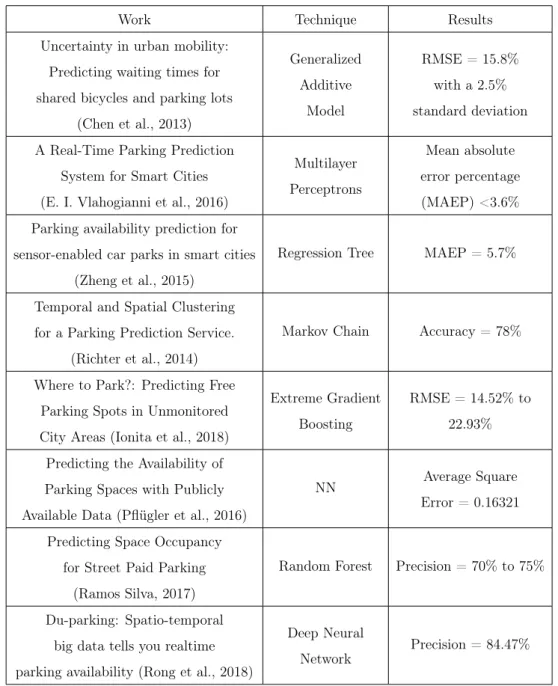
Table 2.3 represents the various techniques used in some studies to predict the parking availability.
Table 2.3: Studies results about the different prediction techniques used for parking availability.
Work Technique Results Uncertainty in urban mobility:
Predicting waiting times for shared bicycles and parking lots
(Chen et al., 2013) Generalized Additive Model RMSE = 15.8% with a 2.5% standard deviation A Real-Time Parking Prediction
System for Smart Cities (E. I. Vlahogianni et al., 2016)
Multilayer Perceptrons
Mean absolute error percentage (MAEP) <3.6% Parking availability prediction for
sensor-enabled car parks in smart cities (Zheng et al., 2015)
Regression Tree MAEP = 5.7%
Temporal and Spatial Clustering for a Parking Prediction Service.
(Richter et al., 2014)
Markov Chain Accuracy = 78%
Where to Park?: Predicting Free Parking Spots in Unmonitored City Areas (Ionita et al., 2018)
Extreme Gradient Boosting
RMSE = 14.52% to 22.93% Predicting the Availability of
Parking Spaces with Publicly Available Data (Pflügler et al., 2016)
NN Average Square Error = 0.16321 Predicting Space Occupancy
for Street Paid Parking (Ramos Silva, 2017)
Random Forest Precision = 70% to 75%
Du-parking: Spatio-temporal big data tells you realtime parking availability (Rong et al., 2018)
Deep Neural Network
Conceptual Model of Park Aid App
This chapter focus on showing the conceptual model of the system being developed to deal with various parking availability problems inside a big city, as it can see in Figure 3.1. In this case the principal focus is to guide a driver to a parking lot with an available parking space. The system is composed by various components, namely the Final Dataset, Predictive Model and the Decision Algorithm. There was also the development of an interface where the proposed solution would be integrated, so the users could interact with it. The interface created is an android application, named ”Park Aid”, where the user can interact with the system and get information about the parking lots, namely the current occupation rate, the price per hour, the working period, and more.
This conceptual model follows a similar architecture of what is described in (Alface, Ferreira, & Pereira, 2019), with only a few components additions, but framed with the parking availability paradigm instead of electric vehicle charging. In the following subsections each component of the proposed solution being created is being presented.
Figure 3.1: Conceptual Model Diagram
3.1
Final Dataset
In Chapter 4 three different data sources are analyzed and a feature selection is made to create the Final Dataset. This dataset is going to be used in the con-struction of the predictive model and so maintaining the most helpful features is important since these features increase the prediction accuracy of the parking availability, being this the first objective of this study. Also, the removal of use-less features contributes to the reduction of the computational time required and reduces possible prediction errors.
The first data source being used is the parking occupancy data from three park-ing lots in Lisbon situated around the Marquês de Pombal area, from 1 October 2018 to 31 January 2019. The second data source is the weather data of Lisbon, with hourly historical weather data, and the third data source is traffic data of Lisbon, able to provide traffic information in the surroundings of each parking lot. Historical data is very cost-effective and does not depend on the user, since it is possible to understand cyclical patterns (Tilahun & Di Marzo Serugendo,
2017). Although the current data is not sufficient to cover the annual pattern, historical data is really important when dealing with the prediction of the park
occupancy, giving us the advantage of generalized trends over time periods (Richter et al., 2014). To have this coverage, the information of the occupation values in the parks is saved by monitoring the number of cars entering and exiting the parking lot, allowing you to have the precise number of cars in the parking lot without incurring a large associated cost like when monitoring every single space (Klappenecker et al.,2014), as is the case with parking lots using sensors (Amato et al., 2017), but in contrast measuring flow on the entrances and exits of the parking lot is not capable of giving the exact position of a free parking space and can only be implemented on closed parking lots, as is our case.
3.2
Predictive Model
Next component is the Predictive Model, being exploited in Chapter 5 and cor-responding to the second objective, that gives the availability rate of a parking lot at an interval time. This Predictive Model is created by applying a supervi-sioned predictive algorithm from the python H2O library (H2O.ai, 2019) to the Final Dataset obtained after the feature selection performed in Chapter 4. The predictive model is built in a local server and then exported to the ”Park Aid” ap-plication, having certain effects on the final solution, like increasing the total size of the application and the battery drainage. The algorithm chosen is evaluated in Chapter 5, as various algorithms are tested and examined to decide which one is the most desirable, while taking into consideration the accuracy levels and the performance, since the execution time is important inside an android application. The developed approach can be applied to any parking lot with similar character-istics, by introducing the necessary features. Further details from the predictive model and the data used in the creation of the model are further explained in Chapter 5.
3.3
Decision Algorithm
The last component is the Decision Algorithm which meets the third objective, being developed in Chapter 6. This algorithm will be responsible for suggesting the most suitable parking lot for the driver. The decision algorithm will take into account various heuristics to be able to output which parking lot best fits the current driver, heuristics like the current driver’s position and the parking lot characteristics, as well as the parking lot occupancy obtained through the developed predictive model in Chapter 5, are taken into consideration and are necessary for the proper functioning of the decision algorithm.
3.4
Park Aid Android Application
”Park Aid” is the interface responsible to give the user a friendly and intuitive way to interact with the proposed solution. The main idea of the App is to contain information about the various parking lots so that each one has a predictive model associated that provides the occupancy rate of the parking lot at any given time, as well as guiding the user to the best parking lot option suggested by the decision algorithm.
To improve and make it easier for drivers to find an available parking space, two options named "Navigate" and "Check Map" have been created. These options present information and the location of the parking lots, as well as the parking lot characteristics in order to enable users to plan and choose the right route. This options are also able to plot the route from the users current position to the chosen destination parking lot, so that users who are not familiar with the city have help in finding the final destination.
The first step when entering the application is the login, where the user needs to put his credentials to log in the application, and in case it is the first time logging in, the user can register a new account by providing the email, username and a password. After filling the login credentials and entering the app, the user
is greeted with a two option menu, shown by the Figure 3.2, being explained in the next paragraphs.
Figure 3.2: Park Aid application menu.
For the first option of the application, “Navigate”, the driver needs to provide the final destination to travel to, as well as the maximum walking distance willingly to walk, as a way to restrict the search zone. That is, the recommendation of the most optimal parking lot will be carried out within the search radius provided, centred on the final destination. This recommendation is made by the decision algorithm that is developed further in the work, namely in Chapter 6. If no parking lot is found, the closest parking lot will be recommended to the driver.
The second option shown in the menu is “Check Map” and when clicked a map focused in the current user location appears. This map shows markers that represent the location of all of the parking lots, shown in the Figure3.3, and when a marker is clicked a popup information board appears with information of the parking lot, as it can see in Figure 3.4. The information shown is the probability of occupation of the parking lot, the name and description of the parking lot, the address, the working period, the parking fees and a button (”Go to location”) that creates a route to the respective parking lot, having as the starting point the
from the final destination to the parking lot is not taken into account, since this information is not supplied, but information about the percentage of occupation in the park at the end of the route is shown, as well as the duration it would take to reach the park.
Figure 3.3: Parking lots location on the map.
Figure 3.4: Pop-up information board on a parking lot.