Priscila Sousa Silva
Pesquisadora em Geociências do Serviço Geológico do Brasil - DHT
Manaus - Amazonas - Brasil [email protected]
José Eloi Guimarães Campos Professor Titular
Universidade de Brasília – UnB Instituto de Geociências Brasília – Distrito Federal - Brasil [email protected]
Luciano Soares Cunha Professor Adjunto
Universidade de Brasília - UnB Instituto de Geociências Brasília – Distrito Federal - Brasil [email protected]
Luís Henrique Mancini Pesquisador Colaborador Universidade de Brasília – UnB Instituto de Geociências Brasília – Distrito Federal - Brasil [email protected]
Relationships of stable
isotopes, water-rock
interaction and salinization in
fractured aquifers, Petrolina
region, Pernambuco State, Brazil
Abstract
The Petrolina County, Pernambuco State, Brazil, presents speciicities that make it unique from a hydrogeological point of view. Water resource scarcity is both a quan-titative and qualitative issue. The climate is classiied as semiarid, having low precipi-tation, along with high temperatures and evapotranspiration rates. Aquifer zones are related to low connected fractures resulting in a restricted water low in the aquifer. The recharge is limited and the groundwater salinity is high. Stable isotope analyses of H and O were developed in groundwater samples (with different electrical conductiv-ity) and surface water collected in a bypass channel lowing from the São Francisco River. The results were plotted in a δD ‰ versus δ18O ‰ graph along with the curves
of the global and local meteoric water line. Groundwater samples showed unexpected results showing a lighter sign pattern when compared to the meteoric waters. More negative δD and δ18O values indicate an enrichment in light isotopes, which show that
this process is not inluenced by surface processes, where the enrichment occurs in heavy isotopes due to evaporation. The isotopic signature observed is interpreted either as resulting from the water-rock interaction, or as resulting from recharge from paleo rains. The waters are old and show restricted low. So the water-rock contact time is extended. In the rock weathering processes, through the hydration of feldspars, there is preferential assimilation of heavy isotopes at the expense of the lighter ones that remain in the water. Analyses of the 87Sr/86Sr ratio and isotopic groundwater dating
assist in the interpretations.
Keywords:δ18O and δD, Artiicial Recharge, Salinization, Cristaline Aquifer.
http://dx.doi.org/10.1590/0370-44672016710178
1. Introduction
Geosciences
Geociências
Petrolina County is located in the southwestern part of Pernambuco State in the Northeastern region of Brazil (Figure 1). Together with Juazeiro County, it forms one of the most prom-ising irrigation poles in the São Fran-cisco River watershed.
Geologically, the region is located between the boundary of the São Fran-cisco Craton and the Borborema Province which is represented by the Riacho do Pontal Mobile Belt. In the southern region of the county, there are outcrops of the Gavião Block rocks mainly gneiss. In the northern portion, the rocks of the Riacho do Pontal Mobile Belt are exposed and
represented mainly by schist and marble. The rocks are dated from the Archean to the Neoproterozoic Eras. Figure 2 presents images from rock outcrops observed dur-ing ieldwork in the region.
The soils are not thick and show low pedogenetic evolution. The recent alluvial sediments are observed in the vicinity of the intermittent rivers with thicknesses ranging from 5 to 10 meters. There are literature reports screening the existence of alisol, aridisol, incepsol, andisol, entisol and vertisol. All these not evolved soils are rich in free ions, mainly in the saprolitic horizons or even in shallow horizons of incepsol, aridisol and vertisol derived from
gneiss, granite, granulite, basic, ultrabasic rocks and marble.
The climate in the region is classiied as semiarid, which is characterized by spa-tial and temporal irregular rains. The total mean rain is about 450mm/year and the rains concentrate from January to March. The temperatures and the evapotranspira-tion are high. The average temperature is 26°C and the evapotranspiration varies from 1,200mm to 1,500mm per year. Re-lief shows a smooth pattern with isolated sparse hills and lat and shallow valleys.
20 REM, Int. Eng. J., Ouro Preto, 71(1), 19-25, jan. mar. | 2018
Figure 1
Location map of the study area,
Petrolina County, Pernambuco State, Brazil.
The issue of the water resource deiciency is both from a quantitative and qualitative standpoint. Climate, geology and soils control the quantity and the high salinity of groundwater controls the quality. The high salinity of groundwater is given by the joint action of factors such as: climate, soil, high rate of evaporation, plane relief, low con-nected fractures, restricted circulation of water in the aquifer, and high water-rock time contact. Several authors have presented explanations for the causes of the increasing ion content in the water which are focused on different processes:
dry and warm climate conditions, salt enrichment in the soils and water-rock interaction (Silva Junior et al., 1999;
San-tiago et al., 2000; Silveira & Silva Junior,
2002; Costa et al., 2006; Lima, 2010).
The only perennial stream in the region is the São Francisco River. The aquifers are related to low intercon-nected fractures zones. Sub horizontal fractures that interconnect the larger vertical fractures were observed serving as preferential low paths and storage space for water. The low in these aqui-fers is restricted and causes the high residence time of water in fractures. The
regional low is rather limited and the water accumulations occur in systems of isolated fractures resulting in wells that are located relatively close to each other, having different hydraulic characteristics and electric conductivity of the water.
Figure 2 Outcrops of typical rocks observed in the Petrolina region.
2. Material and method
Stable isotope δDvsmow and δ18O vsmow
analyses were performed in 24 groundwa-ter samples for isotopic characgroundwa-terization of the regional fractured aquifers. Samples are distributed in the region and were chosen in order to contemplate the waters of different salinities.
The water supply in the rural areas is possible through bypass channels that take water from the São Francisco River to the interior. Complementarily, 8 surface water samples were collected along the bypass channel that connects the São Francisco River to the Uruás Village for δDvsmow and
δ18O
vsmow analyses.
Three pairs of samples were taken for
87Sr/86Sr ratio analysis. Each pair consists of
a sample of groundwater collected in a deep well and a sample of weathered rock col-lected in the surroundings of the same well. The analyses were performed at the Geochronology Laboratory of the University of Brasília (UnB), and the water δ18O and δD were measured in the
PICARRO analyzer unit model L2120-i that uses the mass spectrometry method for measurement with laser separation. The values obtained were compared with the VSMOW standard for obtain-ing the precise results. 87Sr/86Sr rates in
water and rock were determined us-ing a TIMS (thermal ionization mass
spectrometer) spectrometer model Triton Plus.
Water ages were determined by the 14 Carbon and the Tritium meth-ods in groundwater for 4 samples with different electrical conductivity values. The analyses were carried out in the HIDROISOTOP laboratory located in Germany by the Accelerator Mass-Spectrometry (AMS) method. The measurements are expressed in % of Modern 14C with double standard deviation. The raw data obtained from the 14 Carbon analyses were replaced in the equation purposed by Allègre (2008):
T
= 8033 . ln
A
14tA
140 (Eq. 01)3. Results
The δDvsmow and δ18O
vsmow
analy-ses of 8 samples collected along the bypass channel that connects the São Francisco River to the Uruás Village were plotted on the graph δ18O
versusδD
along with the global meteoric water line (GMWL). The sample CAN-08 is locat-ed next to the São Francisco River and as the numbering of the samples decreases as they get close to the Uruás Village.
22 REM, Int. Eng. J., Ouro Preto, 71(1), 19-25, jan. mar. | 2018
Figure 3
Graph showing the influence of the
evaporation process by the isotopic signal of the bypass channel that deviates water from the São Francisco River to the Uruás Village.
The twenty four groundwater samples collected in wells have also been plotted on the δ18O versus δD
graph along with the global and local meteoric water line. The curves of the local meteoric water lines were obtained
by the Floresta IAEA GNIP station and by the Salati et al. (1979) which drew
up a local meteoric water line for the northeastern of Brazil.
Surprisingly, the groundwater samples of the Petrolina region were
located above the global and local meteoric water lines. The points of all sampling data align as a curve with R² = 75% correlation. In this research, this line is called as the "Petrolina’s Ground-water Line” (Figure 4).
Figure 4
δD versus δ18O plot showing the isotopic signal of groundwater from Petrolina region. Note that the data align over the local and global meteoric water lines (GMWL and LMWL).
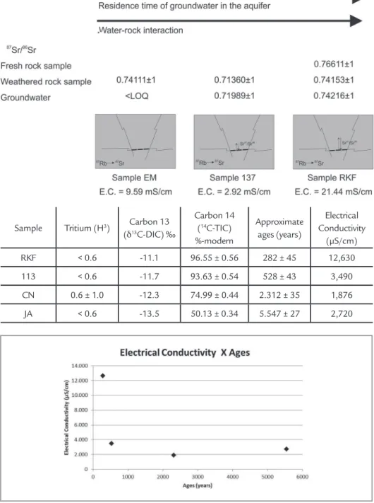
In three pairs of samples collect-ed, an 87Sr/86Sr ratio analysis was
con-ducted comparing the ratio between the groundwater and rock samples. In the RKF sample, it was possible also to collect a fresh rock sample that was also used in the comparison. The results are shown in Figure 5.
Due to the little Sr concentra-tion in the groundwater, water-rock interaction can result after a long time in an isotopic equilibrium with respect to Sr. The sample EM shows
different values of 87Sr/86Sr ratio when
comparing the weathered rock and the groundwater. This means that the process of water-rock interaction did not occur for the necessary time to establish the isotopic equilibrium with respect to Sr. Sample 137 shows more similar values of 87Sr/86Sr ratio. The
groundwater sample RKF shows values of 87Sr/86Sr ratio to be very similar to
the weathered sample, but with values different from the fresh rock sample. This demonstrates that the action of
the water-rock interaction process in the RKF sample, occurs with suficient time to establish the equilibrium with respect to Sr.
4. Discussion
Figure 5 Schematic view showing the analysis of the water-rock interaction process by the 87Sr/86Sr ratio values. The proximity of the values of the 87Sr/86Sr ratio between the weathered rock sample and the groundwater sample is an indica-tive of the water-rock interaction process:
in the EM sample, the process has a poor performance while in the RKF sample, the process almost achieves equilibrium with respect to Sr. L.O.Q.: Limit of
Quantifica-tion; E.C.: Electrical Conductivity.
Sample Tritium (H3) Carbon 13
(δ13C-DIC) ‰
Carbon 14 (14C-TIC)
%-modern
Approximate ages (years)
Electrical Conductivity
(µS/cm)
RKF < 0.6 -11.1 96.55 ± 0.56 282 ± 45 12,630
113 < 0.6 -11.7 93.63 ± 0.54 528 ± 43 3,490
CN 0.6 ± 1.0 -12.3 74.99 ± 0.44 2.312 ± 35 1,876
JA < 0.6 -13.5 50.13 ± 0.34 5.547 ± 27 2,720
Table 1 14C ages of groundwater from Petrolina region.
Figure 6 Plot of the electrical conductivity versus water ages, showing no correlation between these parameters.
The samples collected in the bypass channel show the importance of the evap-oration process for surface water in the semiarid northeast of Brazil. Evaporation makes water enriched in heavy isotopes resulting in water samples plotted below the Global Meteoric Water Line – GMWL and Local Meteoric Water Lines - LMWL. This process, developed in the surface environment, is not observed in groundwater that showed enrichment in light isotopes, since the sampling data are plotted above the Global and Local Mete-oric Water Lines (GMWL and LMWL). There are 2 explanations for the enrich-ment of the light isotopes signal. Either it is related to ancient recharge by paleo rains that occurred in different climatic
conditions, or it is due to the water-rock interaction process, or both of them.
Frape et al. (1984) describe a similar
situation in fractured aquifers in Canada. In the referred to aquifer, fresh water occurs in the shallow parts (depth <650 m) and saline water in the deep parts (depth >650 m). Isotopic studies (δ18O
versus δD) have been done and the fresh water samples are plotted below or on top of the GMWL. However the saline ones are plotted above the GMWL. The authors also made analysis of the 87Sr/86Sr
ratio and the samples of saline water show-ing a strong correlation with the samples of weathered rocks showing water-rock interaction. Finally, the authors concluded that the saline waters have undergone an
intense process of water-rock interaction and that the isotopic sign observed can re-lect either a recharge in a different climate or the process of water-rock interaction (Frape et al. 1984).
The irst hypothesis suggests the aquifer recharge occurred at lower tem-peratures to result in enhanced rainfall in light isotopes. Groundwater dating shows approximate ages ranging from 282 to 5,547 years before present. It is known that the Earth is in an interglacial period that started after the end of the last glacial period approximately 10,000 years to 12,000 years, which can corroborate this explanation.
24 REM, Int. Eng. J., Ouro Preto, 71(1), 19-25, jan. mar. | 2018
use heavy isotopes, causing the fraction-ation of the groundwater and residual water enriched in light isotopes. It’s known that igneous and metamorphic rocks and limestones are enriched in heavy isotopes and have positive values of δ18O and δD
(Allégre, 2008).
In the study area, as in the northeast-ern region of Brazil, the aquifers occur on interconnected fractures with low low or with many stagnation centers resulting in water being a long time in the aquifer, and allowing the development of water-rock interaction processes that take place dur-ing an extended time. In the ieldwork, it was possible to observe that wells located relatively close to each other, can show hydraulic characteristics (yield, static level, speciic capacity) and water characteris-tics (ages, electrical conductivity) quite distinct. This indicates that the aquifers in the area occur in isolated systems of fractures and that there is a not signiicant regional low. These systems of fractures would be interconnected by large sub horizontal fractures that serve as major paths to conduct and store water.
Due to little Strontium (Sr) concen-tration in the groundwater, the water-rock interaction can result after a long time in a isotopic equilibrium with respect to
minerals located in fractures pores and the groundwater (Allègre, 2008).
In the case of carbonates, ground-water tends to relect the 87Sr/86Sr ratio
of the total rock, because these rocks are essentially homogeneous with respect to Sr. On the other hand, in silicates, the
87Sr/86Sr ratio is dominant in the isotopic
composition of speciic minerals result-ing in groundwater with different ratios regarding the total rock, but matching the Sr/Sr of weathered minerals (Montgomery
et al., 2006).
Groundwater from different sources can show different 87Sr/86Sr ratios which
make it a good tool in origin, low ground-water mixture and ground-water-rock interaction studies (Geyh, 2001). Related studies have already been carried out in the Pre Cambrian Shied of Canada, in Mont-Dore region in France (Geyh, 2001) and in England (Montgomery et al., 2006),
among others.
The data analysis for strontium in 3 pairs of samples allows observing that the process of water-rock interaction in groundwater exists in different intensi-ties. The 87Sr/86Sr ratios of the EM sample
are not similar when compared with the groundwater and the weathered rocks. However, in Sample 137, they are. Similar
values. The results conirm the process of water-rock interaction into the isotopic equilibrium with respect to strontium in different intensities.
The water dating results show that there is no relationship between the electri-cal conductivity and the groundwater ages (even considering a small data set, just 4 analyses). The differences in the fracture characteristics (such as geometry and con-nectivity) and in the dissolution rates of minerals that illed the fractures explain the lack of correlation. In areas where the low is restricted and has the presence of more soluble minerals, the salinity of the waters is high but not necessarily is it older. In the region of Petrolina, a set of factors are involved in the high salinity of groundwater, such as: restricted recharge, soils, semiarid climate, plain relief, low connected fractures and process of water-rock interaction. The enrichment in salts in the soils can be a major controller in the groundwater salinization when compared to the water-rock interaction process, which explains the absence of relationship between the E.C. and the groundwater ages. The lack of correlation of the E.C. with the 87Sr/86Sr ratio, which is related to
the water-rock interaction process, also corroborates this explanation.
5. Conclusions
Groundwater salinization is ob-served in several fractured aquifers areas of the semiarid region in northeastern Brazil. It is believed that it can be the result of a joint action of several fac-tors and is not being caused by just one aspect alone.
The dating data prove there is no correlation between the electrical conductivity and the groundwater ages. As the water-rock interaction process is slow, the soil’s salt enrichment is considered as the most important factor for the water salinization. Additionally, the 87Sr/86Sr ratio data and the regional
groundwater isotopic characterization show that water-rock interaction does exist in varying degrees, indicating that this process must also contribute to the ion enrichment.
The majority of the soils in the region are poorly evolved, shallow and enriched in alkali and alkaline earth ele-ments. Precipitation waters percolating
in the soils reach the crystalline substrate and low through open fractures trans-porting the solute. During this process, these may carry soluble elements present in the soils.
Such processes can enrich the waters and increase its salinity before infiltration into the fractures in the rock mass. The plan relief pattern, the crystalline terrain nature, and the thin soil coverage result in high volumes of precipitation waters to remain on the surface as depression storage for a long time where intense direct evaporation (as can be veriied by the isotopic sig-nal of the bypass channel) causes the salt enrichment in the recharge water. Subsequently rains can carry the salts accumulated as depression storage into the fractured aquifers.
The low connectivity of the frac-tures, together with the relief pattern (showing shallow and open valleys), restricts the water velocity circulation,
due to the low gradient of the system as a whole. The longer the time the water stays in the fractures increases the water-rock interaction increasing the salinity.
The groundwater δ18O and δD
sig-nals show enrichment in light isotopes. This can be caused by water-rock inter-action, or by recharge of paleo rains. The irst option occurs by the feldspar hydration processes to form clay miner-als (e.g. kaolinite), that preferentially capture the heavy Oxygen and Hydrogen isotopes. The preliminary 87Sr/86Sr ratio
data conirm the existence of water-rock interaction in the region.
Acknowledgments
The authors are grateful to FINEP (Financiadora de Estudos e Projetos) for the
inancial support to the HIDROFRAT Proj-ect and to CNPq for researchers funding.
References
ALLÈGRE, C.J. Isotope Geology. Cambridge: Cambridge University Press, 2008. 534p.
COSTA, A.M.B., MELO, J.G., SILVA, F.M. Aspectos da salinização das águas do aquífero cristalino no Estado do Rio Grande do Norte, nordeste do Brasil. Águas Subterrâneas, v. 20, n. 1, p. 67-82, 2006.
FRAPE, S.K., FRITZ, P., MCNUTT, R.H. Water-rock interaction and chemistry of groundwaters from the Canadian Shield. Geochimica et Cosmochimica Acta, 48, p. 1617-1627, 1984.
GEYH, M. Groundwater: saturated and unsaturated zone. In: EUA, UNESCO. Envi-ronmental isotopes in the hydrological cycle: principles and applications. EUA: IAEA e UNESCO, 2001. v. 4. 310 p.
LIMA, O.A.L. Estruturas geoelétrica e hidroquímica do sistema aquífero cristalino da bacia do Alto Rio Curaçá, semiárido da Bahia. Revista Brasileira de Geofísica, v. 28, n. 3, p. 445-461, 2010.
MONTGOMERY, J., EVANS, J.A., WILDMAN, G. 87Sr/86Sr isotope composition of
bottled British mineral waters for environmental and forensic purposes. Applied Geochemistry, 21, p. 1626-1634, 2006.
SANTIAGO, M.M.F., FRISCHKORN, H, FILHO, J.M. Mecanismos de salini-zação em água do Ceará, Rio Grande do Norte e Piauí. In: JOINT WORLD CONGRESS ON GROUNDWATER,1. Anais... Fortaleza, 2000.
SALATI, E., LEAL, J.M., CAMPOS, M.M. Isótopos ambientais aplicados a um es-tudo hidrogeológico do Nordeste brasileiro. Recife, SUDENE. n. 58, 1979. 55p. (Série Hidrogeologia).
SILVA JUNIOR, L.G.A., GHEYI, H.R., MEDEIROS, J.F. Composição química de águas do cristalino do Nordeste brasileiro. Revista Brasileira de Engenharia Agrícola e Ambiental, Campina Grande - PB, v. 3, n. 1, p. 11-17, 1999.
SILVEIRA, C.S., SILVA JUNIOR, G.C. O uso de isótopos ambientais em estu-dos hidrogeológicos no Brasil: uma resenha crítica. Anuário do Instituto de Geociência UFRJ, Rio de Janeiro, v. 25, p. 25-43, 2002.