Procedia Computer Science 67 ( 2015 ) 430 – 438
1877-0509 © 2015 The Authors. Published by Elsevier B.V. This is an open access article under the CC BY-NC-ND license (http://creativecommons.org/licenses/by-nc-nd/4.0/).
Peer-review under responsibility of organizing committee of the 6th International Conference on Software Development and Technologies for Enhancing Accessibility and Fighting Info-exclusion (DSAI 2015)
doi: 10.1016/j.procs.2015.09.288
ScienceDirect
6th International Conference on Software Development and Technologies for Enhancing
Accessibility and Fighting Infoexclusion (DSAI 2015)
Cities in citizens’ hands
Leonel Morgado
a,b,*, Rui Rodrigues
a,e, António Coelho
a,e, Olga Magano
b,c, Tânia
Calçada
d,e, Paula Trigueiros Cunha
f, Cynthia Echave
g, Olga Kordas
h, Sara Sama
i, Jennifer
Oliver
j, Jim Ang
j, Farzin Deravi
j, Ricardo Bento
a,k, Luís Ramos
kaINESC TEC, R. Dr. Roberto Frias 378, Porto, Portugal bUniversidade Aberta, R. Escola Politécnica 147, Lisbon, Portugal
cCEMRI, R. Escola Politécnica 147, Lisbon, Portugal dIT, Instituto de Telecomunicações, Av. Rovisco Pais, Lisbon, Portugal eFEUP, Universidade do Porto, R. Dr. Roberto Frias 378, Porto, Portugal
fSchool of Architecture, University of Minho, Guimarães, Portugal gBCNecologia, Agencia d’Ecologia Urbana de Barcelona, Escar 1, Barcelona, Spain
hKTH, Teknikringen 34, Stockholm, Sweden
iUNED, Universidad Nacional de Educación a Distancia, C. Bravo Murillo 38 pl. 7, Madrid, Spain jUniversity of Kent, School of Engineering and Digital Arts, Canterbury, Kent, United Kingdom
kUTAD, Universidade de Trás-os-Montes e Alto Douro, Vila Real, Portugal
Abstract
We propose a new paradigm for public participation in urban planning, a field which presents significant challenges for public understanding and participation. Our approach is based on leveraging the rich diversity of meaning associated with cultural gestures, traditions, folklore, and rituals, and using them in augmented reality systems, in order for citizens’ to explore, understand, and communicate the complex, systemic ideas and concepts associated with urban planning.
At an immediate level, this approach holds the potential for enabling increased public awareness of what is at stake in urban planning - both on the part of citizens and on the part of public officials, policy-makers, and decision-makers – and consequently enhancing understanding and improving participation in public life and citizenship. It may also open up a new field of research and development in human-computer interaction, to leverage the richness of meaning and modes of expression which exist in various cultures and societies, rather than ignoring them and imposing dumbed-down or prescribed command methods. Thus, it aims to facilitate new levels of empowerment of users in the use of digital systems and data. The active utilization of cultural
* Corresponding author. Tel.: +0-000-000-0000 ; fax: +0-000-000-0000 .
meaning in gestures, rituals, and social practices may also support and promote better inclusion and participation of minority groups and migrant communities in contemporary, technology-rich life.
© 2015 The Authors. Published by Elsevier B.V.
Peer-review under responsibility of organizing committee of the 6th International Conference on Software Development and Technologies for Enhancing Accessibility and Fighting Info-exclusion (DSAI 2015).
Keywords: urban planning; smart cities; gestural interaction; augmented reality; shamanic interface; interactive storytelling
1. Introduction
Public understanding and informed participation in urban planning is challenging due to its complex nature as a systemic, location-based field [1]. As Albeverio et al. [2] put it, “the dynamics of cities can be best captured by looking at them as complex systems governed by many degrees of freedom, interacting on different space and time scales in a non-linear fashion.” Considering the increased availability of both live and historical data about cities – particularly in the new “smart cities” contexts [3] – we propose tackling this complexity not just by using augmented reality systems, but by combining them with input methods based on cultural-based gestures, rituals, and social practices. The goal is to enable users to conduct location-based, contextual in-depth exploration of interconnected concepts and data, for better understanding of the systemic interactions of urban planning. And, conversely, to enable users to present their own ideas and proposals for their cities to decision-makers and public officials, by using the same tools to create and share interactive stories.
At a more immediate level, this approach holds the potential of enabling technologies for increased public awareness of what is at stake in urban planning, both on the part of citizens and on the part of public officials, policy-makers, and decision-makers, and consequently enhanced understanding and improved participation in public life and citizenship. In future smart cities, increasingly data will be shared and available for public access, which enables citizens’ interaction out of the conventional indoor/restricted and private areas. The public space becomes a place for real-time and real-space expression and interaction, either with personal devices and connectivity or via information kiosks or booths placed on public spaces, with computationally-favorable conditions. The culturally-diverse meeting of citizens and decision-makers promoting mutual understanding may thus take place within a comprehensive, data-rich environment: a multi-dimensional and techno-artistic environment. We envision that the interaction with that environment is empowered by means of culture-based interaction systems. This perspective may even open a new field of research and development in human-computer interaction, beyond urban planning itself, to leverage the richness of meaning existent in the cultures of human societies - rather than ignoring them and imposing interaction methods that are either dumbed-down or require learning and mastering a prescribed command set (visual or otherwise). Thus, while here we are focusing on urban planning as a focal problem, our proposal may hold the potential of opening up new levels of empowerment of users in the use of digital systems and data, and provide a pathway for better inclusion and participation of minority groups and migrant communities in contemporary, technology-rich life. In the long term, the vision is that new technologies will have to be developed to better combine human-sourced actions with contextual cues and semantic information, by acknowledging the various cultures present in the cultural contexts, to exploit for interaction the cultural meanings found in gestures, rituals, and social practices of human societies.
2. Background
Public participation is required to attain sustainable urban strategies such as improved urban living conditions, for cohesive and inclusive societies. But this participation is hampered by the systemic complexity of data, which places several challenges for people’s understanding. As Checkland put forward [4], the nature of a system involves its layered structure of subsystems, the process of communication between the system and its environment, its control processes, and crucially the notion of a system has having emergent properties, that are observable when considering the whole system, but are not present in its components when observed individually. Learning emergent properties is © 2015 The Authors. Published by Elsevier B.V. This is an open access article under the CC BY-NC-ND license
(http://creativecommons.org/licenses/by-nc-nd/4.0/).
Peer-review under responsibility of organizing committee of the 6th International Conference on Software Development and Technologies for Enhancing Accessibility and Fighting Info-exclusion (DSAI 2015)
hard, with people typically relying on over-simplified models/abstractions that in themselves can cause wrong information to be communicated or wrongly perceived, e.g., establishing false causal relationships, among other misconceptions [5]. In the case of cities and urban planning, we further add that the emergent properties include geographic and spatial contexts for interpreting data and outcomes.
To support the understanding of systemic concepts, visualizations are commonly used. They can show what is planned in urban contexts and the possible consequences: geographic information systems, three-dimensional models and animations, simulations or even games and augmented reality technology have all been used in this regard [6]. Augmented reality in particular holds significant potential for understanding urban planning, since it can enable visualization within the physical city environment. An example of current ‘street’ augmented reality may be seen in the humorous bus shelter Pepsi Max advertisement in London (YouTube video: http://bit.ly/1e46xi3). Thus, augmented reality may increase awareness of what it is planned and its impact, enabling urban planning discussions directly in the city, at the street level, allowing citizens to participate in discussions with a more concrete perspective. In our view, this and other cases can be harnessed, and made more widespread using modern portable technologies, from commonplace smartphones and tablets to novelties such as smart glasses.
If visualizations are made interactive, they may further support understanding of complex concepts by leveraging computer-based modelling tools, such as simulators. For instance, by interacting with a model-based visualization, people may witness the outcome of specific actions or input data, countering challenges to our understanding of complex systems, such as their behaviour across large time spans, large numbers of participants, massive data, or dangerous situations. People can model rules to analyze and explore data to reach insights on the operation of complex systems. Modelling tools include spreadsheets, computer programming, scripting, visual modelling, and systems modelling software. They are not yet widespread in augmented reality systems, but several prototype proposals exist: for instance, Chong et al. [7] document how augmented reality can be used to program robot paths; Heun et al. [8] proposed a method to program physical objects’ behaviours and their interactions, among others.
Once people reach insights and generate ideas about complex systems, their ability to communicate them is also a challenging task, involving authoring with modelling software. Both analysis and authoring require users to create and define rules and behaviors. While this can have many names (scripting, configuring, setting up), an encompassing perspective is that these actions are forms of end-user programming, either explicitly or implicitly, including programming by example [9]. But end users are limited by the variety and complexity of computer programming techniques that they have available to craft the rules and outcomes they intend to express. For a computer program (or script, or specification) to work, a person has to convey concepts and intentions in exact and precise ways. To do so, people need to become aware of shortcomings in the exactness and clarity of their conceptions - that is, the lack thereof. This involves providing context to concepts, linking abstractions or fuzzy ideas with the concrete implications of reality or, as the educational theorist Seymour Papert once put it, submitting ideas to the test of reality [10]. Our novel approach proposed herein employs cultural constructs as the means to provide context to concepts, to link abstractions with the concrete [11].
We see citizens as bearers of complex social and cultural knowledge that can be leveraged to meet the challenge of defining rules and behaviors to explore and communicate complex, systemic data and ideas. In particular, as bearers of knowledge that is consistent with the immersion fostered by the mix of real and virtual in augmented reality: the cultural expressions and elements found in body motions and gestures, voice, and tangible object manipulation, among others. It is thus by addressing this technological possibility, and possible pitfalls, that we believe the novelty of our proposed approach lies. The kernel from which this idea evolved - using cultural gestures to interact with computer systems – was published in the previous DSAI conference [12].
3. Proposal
In this paper, we use public participation in urban planning as a focal problem. From a research perspective, we propose combining a human-computer interaction perspective with ethnographic fieldwork from a sociological perspective. The social diversity of people inhabiting modern cities has its roots in social mobility within countries as well as in international migration. Individuals thus have different cultural backgrounds, i.e. different identity and culturally-formed beliefs and behavior patterns, and different ways of being and interpreting the world. These differences imply different ways of being, thinking, acting, living and using urban space and public environments.
The diversity manifests itself in different cultural expressions such as those mentioned above (gestures and others) that have rich layers of meaning, often resulting from structural social differences. This implies ensuring that systems accept different expressions (i.e., different gestures) for the same commands, respecting cultural diversity and backgrounds.
Recently, Natural User Interfaces gained wide dissemination, resorting to tangibles or gesture-based interaction, but “natural” may be a misnomer [13]. They strive to be as seamless and intuitive as possible, but by attempting to be so, they typically avoid the complexity of human nature and provide users with only small sets of gestures or tangibles for intuitive interaction. As a consequence, command sets for advanced interaction often develop counter-intuitive complexity, such as three-finger tapping on screens being different from one/two-finger tapping.
Furthermore, commands are determined in advance and are not personalized. Users have to learn the specific set of interactions predetermined by a systems’ designer – and these may not be universally intuitive, or even include inappropriate gestures for some cultures, such as the well-known case of the thumbs-up gestural emblem which may mean both “OK” or an expletive, depending on the cultural context. Human societies, regardless of technological savvy, have a large set of meaning-rich cultural traditions, such as gestures, rituals, and other social practices, which embody not only intuitive, immediate concepts, but also complex, abstract ideas. For instance, closing one’s hand and placing it near the ear in America can mean “telephone”, while in Portugal or Italy that gesture may be understood as expressing boredom, and “telephone” is expressed by a different gesture: a closed hand by the ear but with the thumb and the little finger extended [14]. Examples of complex, abstract ideas include the use of gestures for expressing satisfaction, such as thumbs-up or joining finger tips on the lips and releasing them while sounding a kiss; opening fingers to express “peace”; gestures from religious rituals; or even establishing indexical relationships between concepts (ibid.).
Let’s consider an example, to render this concept more concrete. At the city of Pombal, Portugal, a social housing complex was built sandwiched between a river, a high-traffic road and a railway. This is a recurrent situation in rehousing, both in Portugal and most other countries. Typically, neighborhoods for rehousing do not take into account the cultural and social fabric, leading to hyper-ghettos and highly marginalized spaces: territorial stigmatization, combined with hyper-incarceration or “prisonfare”/policies punishing the poor, as expressed by Wacquant [20].
As documented in a regional newspaper, while residents enjoyed the homes, they felt “(...) [the city of] Pombal excluded them. (...) the neighborhood is 50 meters from the city, but to reach it, one needs to walk 3 kilometers or cross the [high-traffic road] IC2 on foot” [15] (translated from the Portuguese source text). The solution, which was eventually agreed upon and implemented later that year, was building a small 35-meter bridge across the river, enabling pedestrian access to the industrial area on the other side and its pedestrian access to the city.
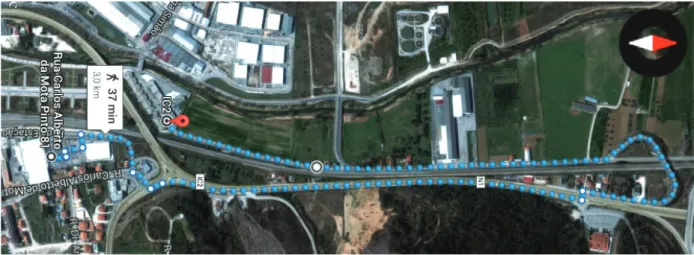
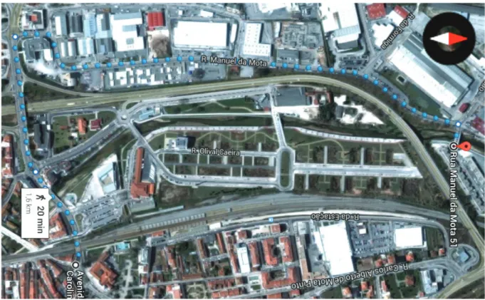
Fig. 1, from Google Maps, helps visualize this. The red pin is at the social housing neighborhood, and the dotted 3-km route shows the path to the city proper (the closest supermarket). The buildings on the top side are an industrial area, and off-access at the time of the news report, due to the river. In the imagery of Fig. 1 the newly-built bridge is visible at the other end of the neighborhood. The actual bridge is shown on Fig. 2. Fig. 3 depicts the new pedestrian access: half the distance (1.6 km) always in industrial or urban surroundings, with sidewalks, and arriving at the city centre, in front of the town hall, not just at the city outskirts.
Fig. 1. The original 3-kilometer pedestrian route to the city outskirts (Google Earth imagery at source coordinates 39.922800, -8.630559)
Fig. 3. The current 1.6-kilometer pedestrian route to the city centre (Google Earth imagery at source coordinates 39.922065, -8.632012)
Presented as such, the change may not seem like much: 3 km before, 1.6 km afterwards. However, aerial/satellite imagery, as shown on Figures 1 and 3, allow the identification of some advantages: the 3 km were across rural areas, so it was an entirely wasted commute time, unlike the 1.6 km through industrial and urban areas, which provide job opportunities, services, shops, and the advantages of a central location, such as parks, the bus station, and the railway station. Also, there are bus stops as soon as the residents enter the industrial area, and none on the rural route.
However, it might be debatable whether these advantages would warrant the quick fix of building a short bridge, instead of enduring the previous situation for a lengthier amount of time, until resources could be pooled and building permits collected to enable a more direct route: an underground passageway beneath the road and the railway.
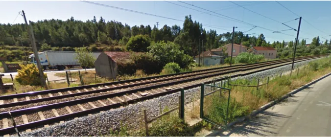
But there is more to it. In Fig. 1, we’ve marked a mid-way point with a white and black circle. It points to an unofficial crossing point on the railway-bordering fence. This would obviously be too tempting and eventually used by pedestrians more, rather than going all the way to the overhead passageway and back, since it cuts the walking distance to just over 1 km, rather than 3. This location, obviously dangerous, is shown in Fig. 4. Further, while walking alongside the road is legal, it is hardly safe, particularly when one considers much of the traffic is by lorries such as the one visible on the background in Fig. 4. On top of this, one can only imagine how walking this route becomes riskier at night time or under bad weather conditions.
Fig. 4. The unofficial midway railway pedestrian crossing onto the high-traffic IC2 road (Google Street View imagery at coordinates 39.925798,-8.629495).
This narrative is possibly compelling enough to put across the actual urgency of the issue at the time, but it required selecting arguments, presenting them clearly, and supporting them with images and illustrations. While its simplicity enabled us to present it in this short space, and possibly contributed to its actual quick resolution on the field (we were not involved in that process), we hope it illustrates for the reader how the values and perspectives of a specific group of citizens may change the public officials’ understanding of issues, when one manages to put one’s point across. Compelling arguments, including personal stories and perspectives, help convey the full aspects of such issues. In the field, this communication is made more complex due to differences in cultural background, educational level, language, bias, prejudice, or other aspects.
Our concept pictures putting into citizens’ hand the power to tell such stories and their perspectives. For instance, while at the actual crossing of Fig. 4, staging an actual crossing for a photograph or videotape would require putting people at risk. But merging virtual characters with the physical images, and letting the virtual characters do the crossing, wouldn’t. The virtual characters could include aspects to make the point even clearer, like representing a student carrying a backpack that can slide while crossing; an elderly lady with long skirts doing it, while taking a young child by hand; people going to work while carrying luncheons or suitcases; etc. It might be necessary to do it during daytime, to be able to videotape the scene, but later be able to change the scene to occur at nighttime or add rain/fog, in order to depict to public officials (or citizens / voters from other neighborhoods) the various aspects of the issue. Possibly different citizens will have different stories or concerns to express in this storytelling way. Counter-arguments or alternative resolutions could be presented to the community in the same way.
To enable this digital storytelling, we envision cultural gestures, leveraging citizens’ cultural background, as stated earlier. In this case, the storyteller could use gestures recognized throughout Portugal, such as “finger walking” while moving an arm forward, towards the railway tracks, to specify that a virtual character should cross them. Two hands close together on the side of the head, while tilting the head to the side, as meaning “sleeping”, could be used to pause the scene, or to change it to night-time (and perhaps using both hands to “rock” the paused scene could be used to wake it up). Or perhaps a user acquainted with wristwatches would rather make a clockwise motion on the back of the wrist to invoke a time-selection overlay menu. We posit that such gestures, if carefully selected to leverage the cultural background of actual users can render the storytelling system easier to learn and empower a wider range of people to present their viewpoints – or to edit and explore other people’s viewpoints.
Also, such methods can enable citizens to visualize and explore available data, such as traffic intensity data across time, pollution levels, and many others.
4. Challenges
Implementing such a concept is particularly challenging. It requires multidisciplinary collaborative research and practice across distant disciplines. The conceptual frameworks and methodologies used in Ethnography, Sociology, Anthropology, Urban Planning, and Design are considerably different from each other as they are from Human-Computer Interaction, which itself is not entirely aligned with Human-Computer Science and Software Engineering. Yet for the success of this approach, such challenges to communication and understanding between researchers and practitioners have to be overcome. This implies a commitment to reach a shared understanding in any such endeavor. Fortunately, there are mechanisms that can be employed to make this shared understanding possible, namely by adopting meta-methods as overall approaches under which other, discipline-specific approaches and methods can operate. This is essential to avoid a situation where different research and practice sub-groups remain isolated within their established disciplinary “comfort-zone”, failing to adequately/effectively share their initial set of norms and values.
One such meta-method is Design Science, whose application to Information Systems was formalized by Hevner et al. [16] and enables the combination of diverse perspectives. For instance, one of its principles is that research must be communicated to diverse audiences of stakeholders, with enough detail to enable its constructions and evaluation across diverse dimensions. The contributions of the various disciplines can thus meet under the principles of Design Science and its three parallel cycles [17]: the Relevance cycle, which analyses the environment of the application domain aiming to support designs which improve it; the Design cycle, which generates artefacts and processes, and evaluates them; and the Rigor cycle, which provides the theoretical grounding for the relevance and the design, and converts their outcomes in additions to current knowledge. In the Relevance cycle, a research and practice effort can conduct an analysis using methods from various disciplines, such as human-computer interaction, sociology, anthropology, media arts, and urban planning, using the Rigor cycle to provide by the theoretical underpinnings of those disciplines. This will inform the Design cycle, where artefact production embodies the contributions of the multidisciplinary effort, and whose evaluation likewise employs methods from the various fields of knowledge. As an example, disciplines from Social Sciences, such as sociology and anthropology can try to capture the rich diversity of meaning associated with cultural gestures, traditions, folklore, and rituals from a pluralistic society with diverse cultural/social backgrounds and develop knowledge that enables Computer Science disciplines such as computer graphics and human-computer interaction together with new media arts to develop new technologies and processes that enable a more intuitive and user-centric participation in public decision processes. Then, the urban planning discipline can use the Constructive Technology Assessment (CTA) methodology for scenario workshops and small scale social experiments [18], to assess the impacts of new technologies before their introduction and diffusion into society. CTA aims at diminishing the societal costs of introducing new technologies by involving stakeholders in early phases of technology development and by organizing and strengthening feedback loops by which stakeholder experiences with the technology are fed back into the technology design process [19].
While the actual way forward for this proposal isn’t clear and requires more research, particularly ethnographic field work and observation, we believe it holds enough promise to warrant the effort of making it happen.
Acknowledgements
The authors would like to thank Norberto Marques, for bringing to their attention the case used herein.
This work is financed by the FCT – Fundação para a Ciência e a Tecnologia (Portuguese Foundation for Science and Technology) within project UID/EEA/50014/2013.
References
1. Portugali J, Meyer H, Stolk E, Tan E, editors. Complexity Theories of Cities Have Come of Age - An Overview with Implications to Urban
Planning and Design. New York: Springer Heidelberg Dordrecht, 2012.
2. Albeverio S, Andrey D, Giordano P, Vancheri A. The Dynamics of Complex Urban Systems - An Interdisciplinary Approach. New York: Physica-Verlag Heidelberg, 2008.
3. Neirotti P, De Marco A., Cagliano AC, Mangano G, Scorrano F. Current trends in Smart City initiatives: some stylised facts. CITIES 2014;
4. Checkland P. Four Conditions for Serious Systems Thinking and Action. Systems Research and Behavioral Science 2012, 29(5):465-469. 5. Chi MTH, Roscoe RD, Slotta JD, Roy M, Chase CC. Misconceived Causal Explanations for Emergent Processes. Cognitive Science 2012,
36(1):1-61.
6. Hanzl M. Information technology as a tool for public participation in urban planning: a review of experiments and potentials. Design Studies 2007, 28:289-307.
7. Chong JWS, Ong SK, Nee AYC, Youcef-Youmi K. Robot programming using augmented reality: An interactive method for planning collision-free paths, Robotics and Computer-Integrated Manufacturing 2009, 25(3): 689-701.
8. Heun V, Kasahara S, Maes P. Smarter objects: using AR technology to program physical objects and their interactions. In: Mackay WE, Brewster S, Bødker S, editors. Proceedings of the SIGCHI Conference on Human Factors in Computing Systems. New York: ACM; 2013, p. 2939-2942.
9. Lieberman H. Your wish is my command: Programming by example. San Francisco: Morgan Kaufmann, 2001.
10. Papert S. Introduction: what is Logo? And who needs it. In: Logo philosophy and implementation. Montreal, Canada: LCSI, 1999, p. iv-xvi. 11. Holbert NR, Wilensky U. Constructible Authentic Representations: Designing Video Games that Enable Players to Utilize Knowledge
Developed In-Game to Reason About Science. Technology, Knowledge and Learning 2014, 19(1-2):53-79.
12. Morgado L. Cultural awareness and personal customization of gestural commands using a shamanic interface. Procedia Computer Science 2014, 27:449-459.
13. Malizia A, Bellucci A. The artificiality of natural user interfaces. Communications of the ACM 2012, 55(3):36-38. 14. Haviland JB. Gesture as cultural and linguistic practice. Linguistic Anthropology. Oxford: EOLSS Publishers, 2005. 15. Jornal de Leiria. Moradores de bairros sociais sentem-se marginalizados. In: Jornal de Leiria 2008, July 31, p. 4-5. 16. Hevner AR, March ST, Park J, Ram S. Design science in information systems research. MIS Quarterly 2004, 28(1):75-105. 17, Hevner AR. A Three Cycle View of Design Science Research, Scandinavian Journal of Information Systems 2007, 19(2), art. 4. 18. Parandian A. Constructive TA of newly emerging Technologies, Delft, Netherlands: Delft University of Technology, 2012.
19. Rip A, Misa T, Schot J. Managing Technology in Society – The approach of constructive technology assessment, London: Frances Pinter, 1995.
20. Wacquant L. Marginality, ethnicity and penality in the neo-liberal city: an analytic cartography. Ethnic and Racial Studies 2014, 37(10):1687-1711.