Hossein Bonyan Khamseh Shahid Beheshti University
Tehran - Iran [email protected]
M. Navabi* Shahid Beheshti University Tehran - Iran [email protected]
*author for correspondence
Development of access-based
metrics for site location of ground
segment in LEO missions
Abstract: The classical metrics of ground segment site location do not take account of the pattern of ground segment access to the satellite. In this paper, based on the pattern of access between the ground segment and the satellite, two metrics for site location of ground segments in Low Earth Orbits (LEO) missions were developed. The two developed access-based metrics are total accessibility duration and longest accessibility gap in a given period of time. It is shown that repeatability cycle is the minimum necessary time interval to study the steady behavior of the two proposed metrics. System and subsystem characteristics of the satellite represented by each of the metrics are discussed. Incorporation of the two proposed metrics, along with the classical ones, in the ground segment site location process results in inancial saving in satellite development phase and reduces the minimum required level of in-orbit autonomy of the satellite. To show the effectiveness of the proposed metrics, simulation results are included for illustration.
Key words: Site location of ground segment, LEO satellite, Total accessibility duration, Longest accessibility gap, In-orbit autonomy.
INTRODUCTION
In recent years, limited inancial resources of space activities and the new paradigm of more responsive satellite systems have brought signiicant attraction toward management of various aspects of ground segment (Peter, 2006; Chester, 2009; Sandau, 2010). One of the most important aspects regarding effectiveness of the ground segment is its site location (Elbert, 2001). Classical metrics of ground segment site location in satellite missions are mainly derived from terrestrial or geostationary communication experiences. These metrics are based on topographical, atmospheric and electromagnetic aspects of ground segment location and its surroundings. Various atmospheric-attenuation phenomena were discussed by Roddy (2006) which may impose constraints on ground segment site location process. Elbert (2001) proposed proximity to the required resources, compatibility with international/national frequency allocations, operational costs and environmental conditions as the metrics for ground segment site location. As stated by Elbert (2001), International Telecommunication Union (ITU), founded in 1865, is the oldest and most prominent of international organizations in the ield of telecommunication regulations. The same reference stated that clearance and interference in communication frequencies imposes constraints on ground segment site location. Soil condition for building establishment and horizon proile (i.e. neighboring
obstacle height) were added by Ley, Wittmann and Hallmann (2009). Grifin and French (2004) stated that at high frequencies, e.g. X-Band and Ka/Ku, annual rain proile must be considered in ground segment site location, especially if communication with ground segment must be guaranteed. Continuous access between the transmitting source and receiver segment is an inherent characteristic of most terrestrial and high-altitude (35,780 km) geostationary applications (Grifin and French, 2004). Due to high cost of geostationary satellite missions, 500-1,500 km Low Earth Orbits (LEO) mission have begun to gain considerable attention during the last two decades. Regarding near-future activities, Petersen (1994), in his book “The road to 2015” says: “most of the new growth in commercial space appears to be in LEO missions”. In this paper, the pattern of ground segment access to LEO satellites is studied. For LEO satellite missions, pattern of ground segment access to the satellite is made up by short and infrequent access events (Wertz and Larson, 1999). The drawback of classical metrics of ground segment site location is that they do not take account of the mentioned pattern of ground segment access to the satellite in LEO missions.
The contribution of this paper is to develop two access-based metrics so that ground segment site location process takes account of the peculiar pattern of a ground segment access to LEO satellites. The incorporation of the two proposed metrics in ground segment site location process reduces the satellite development cost and lessens minimum required level of in-orbit autonomous operation of LEO satellites.
This paper is organized as follows: in the next section, the minimum time interval to achieve time-independent access-based metrics is studied. Then, numerical method of access pattern determination is presented. Afterward, the two access-based metrics are introduced. System/ subsystems characteristics of the satellite represented by each metric are discussed. Finally, based on simulation results of our case study, access pattern of two ground segments to a given LEO satellite are presented and the two access-based metrics are derived and compared.
ACCESS PATTERN – MINIMUM TIME INTERVAL TO STUDY?
Pattern of ground segment access to a LEO satellite is deined as the chronological order of accessibility events and the consecutive accessibility gaps. Pattern of ground segment access to a LEO satellite varies as the simulation time is increased. This imposes an immediate drawback since access-based metrics will be time-dependent. In order to obtain the access-based metrics in a time-independent manner, minimum time interval after which access patterns are identically-repetitive must be identiied. This time interval is called repeatability cycle and is determined by the following method.
If a satellite completes R full revolutions after D days, the longitude difference between each two consecutive ground tracks at the equator will be:
)L D
R
"2U* (1)
It is noted that, in Eq. 1, D and R are dimensionless values of number of days and number of full revolutions in a given repeatability cycle, respectively. Thus, ΔL in Eq. 1 is in radians.
On the other hand ΔL is the accumulated variation in Right Ascension of Ascending Node (RAAN) in a period. Thus:
<
L"(\e )Tn (2)
In which \e
rad
"
7 2925 10. 5
sec is Earth’s rotation rate,<
is variation rate of RAAN due to J2 effect and Tn is the orbital nodal (draconitic) period, in seconds; < is given by Capderou (2005):
< "
© «ª
¹ »º
3
2 1 2 2 0 2
2
( )
R cos
e
e n J a i (3)
Where:
e: eccentricity;
J2: 0.00108263;
Re: Earth equatorial radius;
a : orbit semi-major axis;
i : inclination.
Also, the nodal orbital period is determined by Capderou (2005):
T
n n
n"
2
0 U
\ (4)
Where n a 0" 3
µ
is the keplerian mean motion, µ is Earth gravitational parameter, Δn is correction term applied to keplerian mean motion due to variation of mean anomaly and \ is the variation of argument of perigee due to J2 effect. From Capderou (2005):
n e
n J
a i
"
© «ª
¹
ȼ
3
4 1
3 1
2 3 2
0 2
2
2
( )
R
( cos )
e
) (5)
\ "
© «ª
¹
ȼ
3
4 1 2 2 0 2 5 1
2 2
( )
R
( cos )
e
e n J a i (6)
Substituting Eq. 4 into Eq. 2, and equating right-hand sides of Eq. 1 and Eq. 2, the number of revolutions in the repeatability cycle is obtained:
R n n D
e
"
( 0 )
<
\
\ )
(7)
In Eq. 7, only integer values of R give admissible repeatability scenarios. After R revolutions in an integer number of days namely D, the satellite ground tracks will be identical to those obtained in the irst repeatability cycle. Also, assuming inertial Cartesian geocentric reference frame, the position of the ground segment varies periodically, with a period of an integer day. Thus, after D days, the relative geometry between the ground segment and the satellite will be identical, and time-independent access-based metrics are obtained.
As it can be seen from Eq. 3, < is a function of orbit eccentricity, semi-major axis and inclination. Yet, variation of RAAN in sunsynchronous orbits, denoted by
Orbit altitude (km)
Repeatability cycle (days)
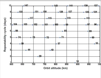
Figure 1: Repeatability cycle of sunsynchronous orbits as a function of altitude.
<SS
rad
" 2 "
365 26 24 3600 1 9965 10
7 U
. . sec
By substituting < = <
SS in Eq. 7, for the altitude range of 600-1,000 km, the repeatability cycle of sunsynchronous orbits is obtained and shown in Fig. 1, in which the number of revolutions is depicted beside the corresponding point in each scenario.
As an example, for a repeatability cycle of 10 days (vertical axis), from Fig. 1 it can be seen that there are 5 distinct sunsynchronous scenarios with 147, 143, 141, 139 and 137 revolutions. These scenarios correspond to orbital altitude of 655, 786, 854, 923 and 994 km (horizontal axis), respectively. The ground tracks repeat after each repeatability cycle. Identical ground tracks, in turn, result in time-independent access-based metrics. Thus, repeatability cycle is taken as the minimum required time interval to study access-based metrics.
NUMERICAL METHOD OF ACCESS PATTERN DETERMINATION
To obtain the pattern of ground segment access to a given satellite, the position of the satellite in its orbit must be determined. In accordance with Cowell’s propagation formula, the translational equation of motion of the satellite in the geocentric equatorial frame is given by Schaub and Junkins (2003):
r r
r a
S S
S p
" µ 3 (8)
Where:
rS: acceleration vector of the satellite; I
rS: position vector of the satellite;
rs: magnitude of position vector of the satellite;
µ: gravitational parameter of earth;
ap: acceleration due to perturbation.
In general:
ap"aNSEaNUMDaTBGaDaSRP (9)
Where:
aNSE: non-spherical Earth effects including aJ
2 (acceleration
due toJ2) and higher terms;
aNUMD: acceleration force due to non-uniform mass distribution of earth;
aTBG: acceleration force due to third body gravity;
aD: acceleration force due to atmospheric drag;
aSRP: acceleration force due to solar radiation pressure.
For LEO orbits higher than 500 km, Fortescue, Stark and Swinerd (2003) stated that acceleration due to J2 effect, i.e. aJ
2, exceeds all other perturbation forces by
2-3 orders of magnitude. Thus, perturbation forces other than the dominant aJ
2are not taken into account in this
paper. To derive an expression for aJ
2, the following form
of Earth gravity potential is adopted from Schaub and Junkins (2003):
V r
r k r J P
k
k k
( , )" ©Re (sin )
«ª ¹ »º ¬
®
¼
¾ ½ ½
" h
1 8 2
µ
O O (10)
Where:
φ : latitude;
Jk: Earth zonal harmonics;
Pk: legendre polynomials.
Legendre polynomials are given by Rodrigues’ formula from Battin (1999):
P
k d d
k k
k
k k
( )
! ( )
" 1
2 1
2
For J2, the gravitational perturbation function RJ r
2
( )I is obtained:
R r J
r R r J e 2 2 2 2
2 3 1
( )I " © ( sin )
«ª ¹
ȼ
ƫ O
(12)
Taking the gradient ofRJ r
2
( )I , the perturbing acceleration
aJ
2due to J2 is given in terms of inertial Cartesian geocentric reference frame as:
I I
a R r J
r R r Z r J J e 2 2 3 2 1 5 2 2 2 " " ©
«ª ¹ »º © «ª ¹ »º © «ª ¹ ( ) »»º © « ª ª ¹ » º º © «ª ¹ »º © « ª ª ¹ » º º © «ª ¹ »º 2 2 1 5 3 5 X r Z r Y r Z r 2 2 © « ª ª ¹ » º º © « ª ª ª ª ª ª ª ª ª ª ¹ » º º º º º º º º º º Z r ¨ µ (13)
To solve Eq. 8, an adaptive, single-step fourth- and ifth-order Runge-Kutta method with Dormand-Prince pair was employed. Time span of integration is [0 tf], where the inal time tf " R Tn .
With satellite position vector available at any given time, ground segment position vector must be determined. Relative to an inertial reference frame, derivative of a moving vector A
I I I
" w\ with constant magnitude is given by
Schaub and Junkins (2003):
dA
dt A
I I I
" w\ (14)
Where \I is the angular velocity vector along the instantaneous rotation axis. Thus, position vector of the ground segment is given by:
I I I I
rGS(ti1)"rGS( ) (ti \ewrGS( ))ti )t (15)
Where:
I
\e" U U
2 1
2 86160
sidereal dayK= secK
ˆ ˆ
Where I
\ " U U
secK
ˆ ˆ is the unit vector of equatorial geocentric frame
in Z direction. In most applications, it is desirable to give initial position of the ground segment (rIGS t0 ) in terms of longitude, latitude and relative altitude on the terrestrial surface. Position vector of the ground segment is given by: I
r ( )t "r (cosI cos I+cos1ˆ Isin ˆ1I+sin K)Iˆ (16)
Where:
r =R +AltGS e GS: ground segment distance from earth center;
AltGS: ground segment altitude relative to mean sea level;
δ: latitude of ground segment;
Λ: longitude of ground segment.
At any given time, position vector of the satellite relative to the ground segment is:
I I I
rS_rel_GS( )t "r tS( )rGS( )t (17)
At any given time, the satellite is accessible from the ground segment if:
J( ) cos ( ) ( ) ( )
t r t r t
r t
GS
"
90 1
I I
S_rel_GS
S_rel GS rrGS
© «
ª ¹
»
º v Jmin (18)
Where Jmin accounts for minimum-elevation constraint,
typically 5 degrees for commercial communication hardware recommended by Roddy (2006).
METRIC DEVELOPMENT AND CASE STUDY
In this section, two metrics are developed to take spaceborne characteristics of LEO satellites into account. Peculiar characteristics of LEO satellites come from the fact that these satellites pass over large areas at high speed, e.g. 7.5 km/s. Consequently, short and infrequent events of ground segment access to the satellite are inherent characteristics of LEO missions. Two access-based metrics, namely total accessibility duration and longest accessibility gap are proposed to capture these peculiar access pattern considerations in the ground segment site location process. To quantitatively study the proposed metrics, a case study will be deined in the next section.
CASE STUDY – SATELLITE ORBIT
imagery purposes suggested by Stephens (2002). The simulation was carried out for a 10-day period from Jan 1, 2010 00:00:00 to Jan 10, 2010 24:00:00. Just as in the case of preceding parameters, a 10-day period relects the upper-bound of revisit-time requirements for various remote sensing applications as stated by Stephens (2002).
CASE STUDY – GROUND SEGMENT SCENARIOS
Throughout the paper, two distinct scenarios for the ground segment in charge of RS-Sat will be discussed. The irst scenario employs a ground segment at 15°E 45°N, i.e. somewhere in Europe. The second scenario employs a ground segment located at 120°W 60°N, i.e. somewhere in northern Canada. To avoid prohibitively-long nomenclature for the two ground segments, they are hereafter called EU-GS and CA-GS, respectively. The location of the two ground segments have been chosen in a manner to best illustrate the variation of access-based
metrics discussed in this paper, exclusively due to site location of the ground segments. As suggested by Roddy (2006), a 5-degree minimum-elevation constraint has been applied in the simulation to take account of the elevation constraint in commercial communications systems.
METRIC OF TOTAL ACCESSIBILITY DURATION
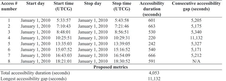
Accessibility to a given satellite is the primary reason to establish the corresponding ground segment. LEO satellites, due to their inherent orbital characteristics, are accessible from a ground segment only in limited portions of their orbits. As an example, simulation results of EU-GS and CA-GS access to RS-Sat in the irst day of simulation are given in Tables 1 and 2, respectively.
As it can be seen from Tables 1 and 2, total duration of EU-GS and CA-GS access to RS-Sat in the irst day of simulation is 2,753 seconds (approximately 46 minutes) and 4,053 (approximately 68 minutes), respectively. Even
Table 1: EU-GS access to RS-Sat in the irst day of simulation Access #
number
Start day Start time (UTCG)
Stop day Stop time (UTCG)
Accessibility duration (seconds)
Consecutive accessibility gap
(seconds)
1 January 1, 2010 6:54:16 January 1, 2010 7:01:56 460 5,213
2 January 1, 2010 8:28:49 January 1, 2010 8:39:54 665 5,369
3 January 1, 2010 10:09:23 January 1, 2010 10:14:31 308 36,342
4 January 1, 2010 20:20:13 January 1, 2010 20:29:25 552 5,227
5 January 1, 2010 21:56:32 January 1, 2010 22:07:16 644 5,361
6 January 1, 2010 23:36:37 January 1, 2010 23:38:41 124 Not applicable
Proposed metrics
Total accessibility duration (seconds) 2,753
Longest accessibility gap (seconds) 36,342
Table 2: CA-GS access to RS-Sat in the irst day of simulation Access #
number
Start day Start time (UTCG)
Stop day Stop time (UTCG)
Accessibility duration (seconds)
Consecutive accessibility gap (seconds)
1 January 1, 2010 5:33:57 January 1, 2010 5:43:58 601 5,205
2 January 1, 2010 7:10:43 January 1, 2010 7:21:46 663 5,175
3 January 1, 2010 8:48:01 January 1, 2010 8:56:51 530 5,340
4 January 1, 2010 10:25:51 January 1, 2010 10:29:31 220 11,132
5 January 1, 2010 13:35:03 January 1, 2010 13:39:05 242 5,327
6 January 1, 2010 15:07:52 January 1, 2010 15:16:52 540 5,171
7 January 1, 2010 16:43:03 January 1, 2010 16:54:09 666 5,212
8 January 1, 2010 18:21:01 January 1, 2010 18:30:52 591 N/A
Proposed metrics
Total accessibility duration (seconds) 4,053
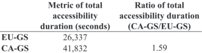
Table 3: Metric of total duration of EU-GS and CA-GS access to RS-Sat for the 10-day repeatability cycle
Metric of total accessibility duration (seconds)
Ratio of total accessibility duration
(CA-GS/EU-GS)
EU-GS 26,337
1.59
CA-GS 41,832
Table 4: Metric of the longest gap in EU-GS and CA-GS access to RS-Sat for the 10-day repeatability cycle
Metric of longest accessibility gap
(seconds)
Ratio of longest accessibility gap (CA-GS/EU-GS)
EU-GS 42,001
0.85
CA-GS 35,815
for medium data volume of 500 MB per day, these very short accessibility durations imply downlink data rate requirements as high as 126-186 KB/sec.
At this point, it is worthwhile to note that in satellite communication subsystem, data rate is a key factor in the required bandwidth for data transfer purposes. According to Shannon–Hartley channel capacity theorem given in Ley, Wittmann and Hallmann (2009):
B R
S N
" © «ª
¹ »º
log2 1 (19)
Where B is bandwidth in Hz, R is bit rate in bit per second, S and N are signal and noise power in Watts, respectively. However, Maini and Agrawal (2007) state that larger bandwidths are viable at higher frequencies. Compared to low-frequency devices, Pelton (2006) states that high-frequency communication hardware is more complex and Dowla (2004) states that it is more expensive. Thus, if data rates are bounded to some moderate values, less complicated and less expensive hardware can be employed for communications purposes, both onboard the satellite and in ground segment facility. This is a key reason why total accessibility duration is introduced and employed as an access-based metric for technical evaluation of site location of ground segments in LEO applications.
Also, according to Eq. 19, another beneit provided by reduced data rate requirement is that required signal transmission power is reduced. Statistical analysis of several spacecraft with various mission types given by Brown (2002) indicated that communication subsystem is one of the main onboard power consumers of satellites. Therefore, if communications tasks are less power-hungry and distributed over longer total accessibility duration, peak power requirements of the satellite are likely to lessen. Thus, lighter and more compact onboard battery units may be employed. In satellite technology, lighter and more compact units with less peak-power requirement simply mean less expense.
It is concluded that, from a management and systems engineering point of view, enhancement of the metric of total accessibility duration is translated into improvement of the cost metrics of satellite projects.
METRIC OF LONGEST ACCESSIBILITY GAP
The longest accessibility gap is the second access-based metric proposed for comprehensive evaluation of site location of ground segment in LEO applications. The longest accessibility gap is deined as the longest duration between two consecutive accessibility events, in a given period of time. In previous research (Elfving, Stagnaro,
Winton, 2003; Rui, Pingyuan and Xiaofei, 2005; Ley, Wittmann, Hallmann, 2009; Chester, 2009; Bonyan Khamseh, 2010; Bonyan Khamseh and Navabi, 2010), the longest accessibility gap is the metric for minimum required level of in-orbit autonomous operation of the satellites. Long accessibility gaps are inherent characteristics of LEO missions. As an example, based on simulation results given in Tables 1 and 2, the longest gap in EU-GS and CA-GS access to RS-Sat in the irst day of simulation was shown to be 36,342 seconds (approximately 10 hours) and 11,132 seconds (approximately 3 hours). From an engineering point of view, long accessibility gap is translated to the requirement of high levels of in-orbit autonomy of RS-Sat. It is recalled that high level of in-orbit autonomy is met by employing sophisticated onboard software packages. These software packages must accommodate decision-making frameworks onboard RS-Sat to handle planned/unplanned events. Also, such complicated software packages are accommodated within heavier and bulkier processing units with more onboard power consumption. Furthermore, since these software packages vary considerably from a mission to another they are developed exclusively for each mission. Consecutively, for long accessibility gaps and the corresponding requirement of high level of in-orbit autonomy, provision of software packages and the hardware to accommodate them can be translated into man-intensive activities and increased development cost.
COMPARISON OF RESULTS AND DISCUSSION
As it can be seen from Table 3, RS-Sat will be accessible from EU-GS for a total period of 26337 seconds, i.e. 7 hours and 19 minutes, in the 10-day period of simulation. On the other hand, total duration of CA-GS access to RS-Sat is 41,832 seconds, i.e. 11 hours and 37 minutes. In other words, total duration of RS-Sat access from CA-GS is 1.59 times longer than that of EU-GS.
Based on the results of simulations, the longest gap in EU-GS and CA-EU-GS access events to RS-Sat were obtained and presented in Table 4.
According to Table 4, the longest accessibility gap in EU-GS access to RS-Sat is 42,001 seconds, i.e. 11 hours and 40 minutes. For CA-GS, the metric of the longest accessibility gap is 35,815 seconds, i.e. 9 hours and 57 minutes. Thus, the longest gap in CA-GS access to RS-Sat is 0.85 shorter than that of EU-GS.
It is noted that the mentioned improvement in the proposed metrics could have been qualitatively deduced since the latitude of CA-GS, in comparison with latitude of EU-GS, is closer to RS-Sat inclination. As a inal point, the mentioned improvements in the metrics of total accessibility duration and the longest accessibility gap are achieved only as a result of modiied ground segment location and, therefore, are gained with essentially no extra cost.
CONCLUSIONS
Two access-based metrics were developed to capture the peculiar pattern of ground segment access to LEO satellites. The irst metric, namely total accessibility duration, represents the required communication data rate, complexity of onboard communications subsystem, peak-power requirement and size of battery units. The second metric, namely the longest accessibility gap, indicates the minimum required level of in-orbit autonomous operation of the satellite. High level of in-orbit autonomy is achievable by man-intensive activities and increased development cost. Thus, reduction in the longest accessibility gap is translated to relaxed schedule and cost saving.
A case study including a LEO satellite and two ground segments scenarios was deined. According to our simulation results, the ground segment location with longer total accessibility duration and shorter accessibility gap was identiied and quantitative improvement in the proposed metrics was presented. By using our proposed approach, along with the classical metrics, one may evaluate various possible ground segment locations and select the position of ground segment in a more effective manner.
FUTURE WORK
In the present paper, we introduced and developed two supplementary access-based metrics for ground segment site location in LEO applications. In our future work we will address semi-analytical optimization of ground segment site location subjected to the prescribed access-based metrics, for various popular LEO orbits.
REFERENCES
Battin, R.H., 1999, “An Introduction to the Mathematics and Methods of Astrodynamics, Revised Edition”, AIAA, Reston, VA, 799 p.
Brown, C.D., 2002, “Elements of Spacecraft Design”, AIAA, Reston, VA, 610 p.
Bonyan Khamseh, H., 2010, “Looking into Future - Systems Engineering of Microsatellites”, In: Arif, T.T. (ed.), “Aerospace Technologies Advancements”, Intech, Croatia
Bonyan Khamseh, H., Navabi, M., 2010, “Development of Metrics for Ground Segment Site Location Based on Satellite Accessibility Pattern from Ground Segment”, The International Council on Systems Engineering (INCOSE), APCOSE 2010 - Aerospace Systems Session, Accepted for publication.
Capderou, M., 2005, “Satellites Orbits and Missions”, Springer-Verlag Berlin, 364 p.
Chester, E., 2009, “Down to Earth systems engineering: The forgotten ground segment,” Acta Astronautica Vol. 65, No 1-2 pp. 206–213.
Dowla, F., 2004, “Handbook of RF and Wireless Technologies”, Newnes, Burlington, MA, 720 p.
Elbert, B., 2001, “The Satellite Communication; Ground Segment and Earth Station Handbook” Artech House, Norwood, MA.
Elfving, A., Stagnaro, L. and Winton, A., 2003, “SMART-1: Key Technologies and Autonomy Implementations,” Acta Astronautica Vol. 52, No 2-6 pp. 475-486.
Fortescue, P., Stark, J. and Swinerd, G., 2003, “Spacecraft Systems Engineering”, John Wiley & Sons, London, 704 p.
Grifin, M.D., French, J.R., 2004, “Space Vehicle Design”, AIA, Reston, VA, 660 p.
Maini, A.K., Agrawal, V., 2007, “Satellite Technology Principles and Applications”, Wiley and Sons, London, 576 p.
Pelton, J.N., 2006, “The Basics of Satellite Communications”, 2nd Edition, International Engineering Consortium, Chicagi ,IL, 372 p.
Peter, N., 2006, “The changing geopolitics of space activities”, Space Policy, Vol. 22, No 2, pp. 100-109.
Petersen, J.L., 1994, “The Road to 2015: Proiles of the Future”, Waite Group Press, Corte Madera, CA, pp. 189-207.
Roddy, D., 2006, “Satellite Communications,” 4th, McGraw-Hill, 636 p,
Rui, X., Pingyuan, C. and Xiaofei, X., 2005, “Realization of Multi-agent Planning System for Autonomous
Spacecraft” Advances in Engineering Software, Vol. 36, No 4, pp. 266-272.
Sandau, R., 2010, “Status and Trends of Small Satellite Missions for Earth Observation” Acta Astronautica, Vol. 66, N. 1-2, pp. 1-12.
Schaub, H., Junkins, J.L., 2003, “Analytical Mechanics of Space Systems”, AIAA, Reston, VA, 716 p.
Stephens, J.P., 2002, “A Novel International Partnership: The Disaster Monitoring Constellation of Small Low Cost Satellites” Proceeding of the United Nations Regional Workshop on the use of Space Technology for Disaster Management in Asia and the Paciic, Bangkok, Thailand.