MAIN FEATURES ASSOCIATED TO THE PRECIPITATION IN
MADEIRA AND THE ATMOSPHERIC RIVERS IN THE WINTER
SEASONS
FLAVIO T. COUTODepartamento de Física, Centro de Geofísica, Instituto de Investigação e Formação Avançada, Universidade de Évora. Rua Romão Ramalho, 59, 7000-671, Évora, Portugal.
[email protected] RUI SALGADO
Departamento de Física, Centro de Geofísica, Escola de Ciências e Tecnologia, Universidade de Évora, Évora, Portugal.
[email protected] MARIA JOÃO COSTA
Departamento de Física, Centro de Geofísica, Escola de Ciências e Tecnologia, Universidade de Évora, Évora, Portugal.
[email protected] VICTOR PRIOR
Instituto Português do Mar e Atmosfera – IPMA, Observatório Meteorológico do Funchal, Funchal, Portugal.
This study presents the main features about 10-year daily accumulated precipitation analysis over the Madeira's highlands, as well as the relationships between this precipitation and the meridional water vapor transport occurring in narrow corridors, also known as atmospheric rivers (ARs). The ARs were visually identified in the total precipitable water vapor field extracted from the Atmospheric Infrared Sounder (AIRS) data, and over a domain covering the North Atlantic Ocean. When needed, ECMWF Analysis were also used as support. The daily precipitation during the study period evidenced generally dry summers, whereas the highest values of daily accumulated precipitation being recorded mainly during the winter, but also occurring during autumn and spring seasons. Moist air emanating mainly from the Caribbean Sea flows northward or eastward intersecting, on some occasions, the Madeira Island throughout the winter seasons, but frequently already in a dissipation stage. In fact, the moist environment created by the ARs can favor the precipitation development, but it is not the sole factor favoring the high rainfall amounts over the Madeira island.
Introduction
Located in the North Atlantic Ocean (32°75'N and 17°00'W), Madeira has an area of approximately 740 km2, consisting of an east-west oriented barrier (58 km of length and
23 km of width), and with a mountain ridge that extends mainly along the central part, with the highest peak reaching a maximum above of 1800 m. During 20 February 2010, Madeira was reached by an event of extreme precipitation, which was the most severe event in its recent history, with more than 40 deaths and damages estimated at millions of
euros. After the disaster, some papers have shown the growing interest in understanding the main mechanisms and atmospheric conditions that are relevant to the establishment of extreme rainfall, and consequently flash flood occurrences in Madeira. The analysis of the event with different methods and meteorological data represents an important step in order to reach this goal (e.g., Fragoso et al., 2012; Levizzani et al., 2013; Teixeira et al., 2014) Couto et al. (2012) introduced another point about the intense precipitation events in the Madeira Island, and underscored the occurrence of atmospheric rivers in the North Atlantic Ocean. They found that besides orographic forcing, the high rainfall amounts observed in Madeira's highlands recorded during the 2009/2010 winter were favored by the passage of weather systems like low pressure and cold fronts. Coupled to these frontal systems, the presence of ARs was identified, which together with the orographic lifting induced the formation of denser clouds, although with relatively weak vertical development.
Zhu and Newell (1998) showed that the majority of the middle-latitude moisture flux occurs in filamentary features, called atmospheric rivers, and that the fraction of the globe they cover is 10% or less. In fact, the ARs play an important role in the tropical and extra-tropical interaction, and when these strong water vapor fluxes encounter a mountainous coastal region, the water vapor content is drastically reduced while the rainfall greatly increase (e.g., Neiman et al., 2008a). The high-impact of the ARs in producing significant precipitation due to the orographic effects, followed by floods and landslides, have been well documented in the last years in studies for the west coast of the USA (e.g. Ralph et al., 2006; Neiman et al., 2008b). For the North Atlantic Ocean, Lavers et al. (2011) showed that ARs transported moisture for the 10 largest winter flood events since 1970 in a range of British basins, demonstrating that this structure is a critical mechanism in extreme winter floods in the UK.
This text is based on the article of Couto et. al., (2015), and has the purpose to analyze the distribution of the daily accumulated precipitation in the Madeira's highlands during 10 years, as well as to present a discussion of the main characteristics associated to the meridional water vapor transport from the ARs structure during 10 winter seasons, and their impact in the rainfall amounts recorded over the island for the same period.
Data and methodology
The Weather Network in Madeira belongs to the Instituto Português do Mar e Atmosfera – IPMA, and currently the Madeira's network is composed by 18 automatic surface weather stations properly distributed over the island. Considering the winter 2009/2010, Couto et al. (2012) showed that, as expected, the precipitation tends to concentrate in the mountainous zones of the island. The present study focuses on the
rainfall distribution at the Areeiro station, located near the mountain crest in the southeastern part of the island, at an altitude of 1590 m. The 10 year period between September 2002 and November 2012 is considered here for the analysis.
In this work, the meridional water vapor transport through the ARs has been identified from the total precipitable water vapor field (unit: kg/m²) extracted from the Level 2 (AIRX2RET), version 005 of the Atmospheric Infrared Sounder (AIRS) data products. The AIRS was launched on May 4, 2002, into a 705 km high, sun-synchronous orbit, and it is on board the Aqua Satellite, which is integrated in the Earth Observing System (EOS), with a global coverage twice per day. Here, the AIRS observations are used for the 10 winter periods between September 2002 and November 2012, totaling 903 days. However, for the winter 2009/10, there are 16 days on January 2010 with no AIRS observations. The data was downloaded for the domain that covers the North Atlantic Ocean and corresponds to the latitudes between 10° N and 60° N and longitudes between 5° E and 100° W. On the other hand, the precipitable water vapor field (unit: mm) from the European Centre for Medium-range Weather Forecasts (ECMWF) analyses is used aiming to support the AIRS data, for example, when there were no satellite information over the island. The analysis were updated each 6 hours and for the same domain used for the AIRS observations, but with 0.125º of resolution, as well as for a period of 10 winters, similarly to the AIRS data.
The methodology adopted for the development of this study consists of three steps: (1) to analyze 10 years of precipitation data over the Madeira’s highlands from the Areeiro station data; (2) to identify the days when there were ARs over Madeira Island during the 10 winter period; and (3) to confront the results obtained in the first two steps for the winter cases, in order to verify the role of the meridional transport in the accumulated precipitation in the Madeira’s highlands.
In this study, the meridional water vapor transport is considered occurring in narrow corridors, also known as atmospheric rivers. A methodology for ARs detection was firstly proposed by Ralph et al. (2004) to study the main aspects of narrow bands with strong horizontal water vapor flux, associated to polar fronts that occurred over the eastern North Pacific Ocean. In general, they considered an atmospheric river as an elongated moisture plume with precipitable water vapor (PW) > 2 cm, which is < 1000 km wide and > 2000 km long. For ARs occurred in the North Atlantic Ocean and that favored the strongest floods in the UK since 1970, Lavers et al. (2012) introduced an ARs detection algorithm, based on Integrated Vapor Transport (IVT), and considered IVT values equivalent used by Ralph et al. (2004).
The identification of atmospheric rivers that intersected the Madeira Island during 10 winter periods was made using the total precipitable water vapor image analysis obtained from the AIRS observations. The large domain was used not only to identify the narrow bands of high moisture content over the Madeira Island, but also to identify the source of
moisture contained in the rivers that reached the island. Unfortunately, sometimes there were no satellite observations over the island, and the ARs identification was made using the precipitable water field from the ECMWF analysis, aiming to confirm the possible ARs episodes identified on the AIRS images.
Since Madeira Island is located at a latitude lower than other regions object of atmospheric rivers studies (e.g., UK and California State), higher values of precipitable water vapor may be observed. Therefore, no threshold is considered here for the precipitable water vapor amount associated to the ARs, which are visually identified as filamentary structures, when their length is several times larger than their width. This feature is clearly visible in the precipitable water field from significant values of precipitable water and presenting a certain horizontal gradient.
Results and discussion 3.1 Precipitation at surface
The daily precipitation at Areeiro was analyzed for the period between September 2002 and November 2012. The seasonal accumulated precipitation showed that the maximum values occurred normally during autumn and winter. The high precipitation amounts during the winter 2009/2010 and autumn 2012, both the wettest periods of the last years, were observed with accumulated values of 2701.9 mm and 2051.7 mm, respectively. Another period of significant accumulated rainfall was the winter 2010/2011, with a total of 1780.5 mm. On the other hand, the summer (301.3 mm) and the autumn (944.5 mm) of 2009 were also very wet, when compared with the same periods in previous years. Overall, these values showed that in the last years there were three seasons with maximums accumulated clearly larger than those observed in the years before and above the seasonal average.
The daily precipitation was classified according to the total of accumulated precipitation in 24 hours (AP) as follows: low (25 mm < AP < 50 mm; green), medium (50 mm < AP < 100 mm; yellow), high (100 mm < AP < 200 mm; red), or extreme (AP > 200 mm; blue).
Firstly considering the warm seasons, there were not many days with significant precipitation during the summers, i.e. with a daily accumulated above 25 mm. Nevertheless, in 2009 the summer was marked by 3 days with daily accumulated precipitation between 50 and 100 mm. On the other hand, all this summer cases occurred in June. For the wet seasons, five events of extreme precipitation (> 200 mm) during the entire period were observed, all in the last years. Overall, three out of the five episodes of extreme precipitation occurred in winter. For the other thresholds, high amounts of
precipitation (100 – 200 mm/day) were recorded in 36 days, while moderate and low accumulated rainfall were observed in a total of 90 days and 96 days, respectively. Rainfall events with daily precipitation between 100 and 200 mm were identified with a major frequency during 2009/2010 winter, totaling 7 days throughout the season, helping to make the 2009/2010 winter the wettest of the entire study period.
3.2 AIRS observations and the meridional water vapor transport
The visual analysis of the AIRS satellite images confirmed the fact that sometimes the Madeira Island is located in the pathway of these filamentary structures with significant amount of precipitable water vapor. These structures were identified and classified as atmospheric rivers, since they had a length larger than the width, and clearly represented the transport of high moisture amounts from the tropical regions to higher latitudes. Following the criteria for the ARs selection described previously in section 2, for the 10 winter periods considered, 56 days were selected when this structure was found exactly over the island or very close. From the images, it has been verified that many rivers pass over the island in a dissipation stage, when the filamentary structure is no longer well defined.
From these 56 days, 37 were considered as well configured rivers before and during the passage over the island. These days accounted for 32 atmospheric river episodes, since five of them were observed passing between 2 days.In some cases, only one of the two daily satellite images is sufficient to verify the presence of the ARs over the island. However, in 3 of the 32 episodes, the ECMWF analyses were necessary in order to support the AIRS observations, confirming the water vapor transport toward the island. For the first 6 winters analyzed, it was possible to observe that the filamentary transport of water vapor toward the island had a significant frequency with 5 episodes in 2002/2003 winter, and followed by a low frequency period, with occurrences not exceeding four episodes in 2005/2006, three cases during the winter of 2006/2007, and no occurrences in the winters of 2003/2004, 2004/2005, and 2007/2008. On the other hand, in the last years, the meridional transport of water vapor over Madeira, organized as atmospheric rivers, was more frequent, with 5 episodes in the 2008/2009 winter, 10 episodes in the winter 2009/2010 and 5 in 2010/2011 winter. Finally, in the 2011/2012 winter, no rivers were identified passing directly over the island. Although no ARs were identified passing over the island in these periods, it does not mean that there were no rivers over the Atlantic, just that this kind of meridional transport has not be observed reaching the island. As mentioned earlier, many rivers pass over Madeira already in a dissipation stage, which eliminated some cases.
Another point associated to the ARs occurrence is the amount of precipitable water vapor that must be identified or transported to the island, during wintertime, in order to
induce an episode with the magnitude of the disaster on February 20, 2010. It was noted that the majority of the rivers contain a total of precipitable water vapor around 35 kg/m². However, filamentary structures with amounts near 25 kg/m², or above 50 kg/m² have been identified. Notice that apart from the frequency, the rivers during the 2009/2010 winter were also more intense, characterized by the highest values of precipitable water vapor, with episodes presenting amounts above 40 kg/m², or 50 kg/m², as observed on 20 February 2010. In the 2010/2011 winter, the significant frequency of these structures did not have an intensity such as that observed during the winter 2009/2010, with just one episode presenting precipitable water vapor above 45 kg/m². The relation between the passage of atmospheric rivers and the accumulated rainfall on the top of the island will be presented in the next sub-section.
From the analysis of AIRS observations it was possible to identify some patterns regarding the orientation of the water vapor transport that reached Madeira Island during the winter seasons. As stated before, no threshold was considered, since filamentary structures were observed with precipitable water vapor values ranging from 25 kg/m² to 50 kg/m². In general, two main types were identified, while one of these may be subdivided in three distinct ways. These configurations are separately described below, each one with its main features.
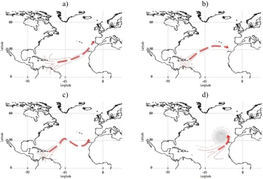
TYPE 1: narrow corridors (few hundred kilometers of width and thousands of kilometers of length). For this type, the moisture source is identified over the Caribbean Sea, and supporting the concept of intense water vapor transport from the tropical zone toward the Pole, the filamentary structure extended, in some cases, up to latitudes higher than 50°N. This pattern could be divided in three types, since the same configuration is present (narrow corridors, source in the Caribbean Sea), but with different kind of pathways. The pattern TYPE 1a (Figure 1a) is characterized by a southwest-northeast orientation over the island, and therefore, a typical southwesterly flow. In the second type identified (TYPE 1b; Figure 1b), the Caribbean vapor reaches the island as a westerly flow, established around the latitude of 30°N. Sometimes, a meridional undulation of this westerly flow is observed, creating a type of valley, apparently forced by the displacement of drier air masses from the higher latitudes toward the subtropical zones. In these cases the filamentary structure is observed passing over the island as a southwesterly flow, generally weaker than when the transport is of the type 1a (Figure 1a). This configuration represents the Type 1c (Figure 1c).
TYPE 2: This pattern, unlike the first type, seems to be associated to a cyclonic circulation, centered near the Azores's Archipelago, northwestern of the Madeira. In this configuration (Figure 1d), the aspect of a warm conveyor belt is more clear than in the first type, which can be associated to extra-tropical cyclones centered in higher latitudes. This type of transport does not occur as narrow bands, but a structure with a length greater than the width is clearly visible, which transports large precipitable water vapor
amounts from the lower latitudes. In this pattern, the source of water vapor is located in the central part of the Tropical Atlantic Ocean. The river passes over the island also as a south-southwesterly flow, moreover, being more latitudinal than meridional.
Each atmospheric river episode was classified as one of these two types. The analysis highlighted that the Type 1 was more frequent than the Type 2, which was identified reaching the island only three times, while the Type 1 was identified 29 times, considering the three sub-types.
a) b)
c) d)
Figure 1. Patterns of the meridional water vapor transport that reached Madeira Island during the winter seasons considered. TYPE 1: Narrow corridors presenting over the island a (a) south-westerly flow – Type 1a, (b) westerly flow – Type 1b, (c) south-westerly flow – Type 1c; TYPE 2: Warm conveyor belt presenting a (d) south or south-westerly flow. Source: Couto et al., 2015.
To summarize, the results showed that during the winter seasons, tropical moisture transported through the ARs reaches the Madeira Island occasionally, with different intensities and orientations. For a transport occurring as the Type 1, total precipitable water vapor between 25 to 35 kg/m² over Madeira is frequently identified. However, sometimes the amounts observed are greater, and these filamentary structures present in the central regions values greater than 40 kg/m² (this feature was observed mainly for the
Type 1a). On the other hand, the second type, even less frequent, was associated to total precipitable water vapor values above 30 kg/m².
3.3 Atmospheric rivers and the precipitation in Madeira
Comparing the results obtained in the sub-sections 3.1 and 3.2, only one of the three winter cases of extreme accumulated precipitation may be associated to the meridional water vapor transport from the tropical region. In the cases of high daily accumulated precipitation (100 to 200 mm), the subjective analysis showed that 8 of the 17 episodes were favored by rivers. Apparently, the episodes with lower daily accumulated values were not greatly influenced by this transport. In 6 cases of ARs over Madeira, precipitation was not measured in the Areeiro station. However, precipitation was recorded in other places of the island on these days. In the rest of the river episodes, the daily accumulated precipitation at Areeiro was lower than 25 mm or zero. Overall, these results show that the impact of the rivers in the accumulated precipitation in the winter season in the period 2002-2011 was not so great as suggested by the 2009/2010 winter, studied by Couto et al. (2012).
Conclusions
This study analyzed the main aspects related to the Madeira's highlands precipitation over a 10 year period. Features associated with the meridional water vapor transport occurring in narrow bands with high precipitable water vapor amounts, also known as atmospheric rivers, as well as their impact in the precipitation recorded in Madeira during 10 winter periods are also presented.
The daily accumulated precipitation at the surface, showed generally dry summers, while the highest accumulated precipitation are recorded mainly during the winter, although some significant events may occur also in autumn and spring seasons. The 2009/2010 winter was the wettest season of the entire period of study, followed by the wettest autumn observed in 2012, both with seasonal accumulated precipitation above 2000 mm.
The patterns of the precipitable water vapor field when ARs reach the island were investigated, and even if great part of the atmospheric rivers reaches the island in a dissipation stage, some rivers are heavy enough to reach the Madeira Island. In this situation, the water vapor transport could be observed in two main configurations and transporting significant water vapor amounts toward the Madeira from the tropical region.
This study found that atmospheric rivers with precipitable water above 40 kg/m² favored the occurrence of high accumulated precipitation during wintertime. In the 2009/2010 winter the moisture transport over Madeira associated to atmospheric rivers was more intense and frequent, and was essential for the occurrence of significant precipitation over the island, as concluded in a previous work (e.g., Couto et al., 2012). However, considering the 10 winters period, it may be concluded that the rivers did not play an exclusive role in the onset of high precipitation events.
Therefore, this study lead to conclude that the atmospheric rivers, when associated to high values of precipitable water vapor over the island can provide favorable conditions to the development of precipitation, sometimes associated with high amounts. On the other hand, we suggest that an objective analysis of these structures could be made using an automatic method.
Finally, it was found that many cases of high to extreme accumulated precipitation at the surface were not associated to this kind of meridional water vapor transport. This constitutes a motivation for future research about precipitation in the Madeira Island, aiming at a better understanding of the environments that favors the occurrence of significant precipitation in that region, other than considering only the atmospheric river transport concept. Moreover, the results may be useful in the study of significant precipitation events in Madeira.
Acknowledgments
This study has been supported by the Portuguese Science and technology Fundation (FCT) through grant SFRH/BD/81952/2011. The authors also acknowledge the founding provided by Évora Geophysics Centre, Portugal, under the contract with FCT, Pest-OE/CTE/UI0078/2014.
References
Couto FT, Salgado R, Costa MJ. 2012. Nat. Hazards Earth Syst. Sci., 12, 2225-2240. Couto FT, Salgado R, Costa MJ, Prior V. 2015. International Journal of Climatology. doi: 10.1002/joc.4243.
Fragoso M, Trigo RM, Pinto JG, Lopes S, Lopes A, Ulbrich S, Magro C. 2012. Nat.
Hazards Earth Syst. Sci., 12, 715-730.
Lavers DA, Allan RP, Wood EF, Villarini G, Brayshaw DJ, Wade AJ. 2011. Res. Lett., 38, L23803.
Lavers DA, Villarini G, Allan RP, Wood EF, Wade AJ. 2012. J. Geophys. Res., 117, D20106.
Levizzani V, Laviola S, Cattani E, Costa MJ. 2013. European Journal of Remote
Neiman PJ, Ralph FM, Wick GA, Kuo Y-H, Wee T-K, Ma Z, Taylor GH, Dettinger MD. 2008a. Mon. Wea. Rev., 136, 4398-4420.
Neiman PJ, Ralph FM, Wick GA, Lundquist J, Dettinger MD. 2008b. J. Hydrometeor., 9, 22-47.
Ralph FM, Neiman PJ, Wick GA. 2004. Mon. Wea. Rev., 132, 1721-1745.
Ralph FM, Neiman PJ, Wick GA, Gutman SI, Dettinger MD, Cayan DR, White AB, 2006. Geophys. Res. Lett., 33, L13801.
Teixeira JC, Carvalho AC, Carvalho MJ, Luna T, Rocha A. 2014. Nat. Hazards Earth
Syst. Sci., 14, 2009-2025.
Wick GA, Neiman PJ, Ralph FM. 2013. IEEE Trans. Geosci. Remote Sens., 51, 2166– 2176.