#86
CONFIGURATION OF SELF-ORGANIZING INFORMALITY:
Socio-spatial dynamic in favelas
VÂNIA RAQUEL TELES LOUREIRO PPG-FAU/UnB
VALÉRIO AUGUSTO SOARES DE MEDEIROS
Universidade de Brasília – PPG/FAU/UnB, Câmara dos Deputados, Unieuro [email protected]
MARIA ROSÁLIA GUERREIRO CRIA ISCTE-IUL
ABSTRACT
This paper aims to discuss on spatial patterns found in favelas throughout different cities worldwide, as they seem to reproduce similar configurations and urban dynamics despite its diverse local contexts. The purpose is to explore these patterns in order to understand its social behaviour and address urban informality issues through it. To see how resilience seems to be inherent to such spaces, that grow vibrant, complex and dynamic global structures emerging and self-organizing from segregation in city space. It pursues the acknowledgement of structural morphological patterns of informality production, those genotypic characteristics that seem to be independent on culture, and might be representative of these social patterns commonly observed worldwide. Favela is observed in this study as a complex, self-organized entity, whose contrast to official city relies on its “bottom up” structure. It tends to follow natural rules of organization instead of formal urban strategies. Space Syntax (Hillier and Hanson, 1984) is the theoretical and methodological approach applied, through which it is possible to investigate these peculiar spatial patterns in favela, comparing several cases in Latin America, Africa and Asia. The analyses are based on axial and segment maps. Investigated variables are connectivity, local and global integration, mean depth, synergy, intelligibility, angular Choice, number and length of axes, and number and length of segments, compactness, normalized angular integration and choice for segment comparison. Findings show favela as an entity that maximises use and space into strong fragmented spatial structures, which provides the labyrinthic perception of users, but also accentuates spatial hierarchy. Topography is critical to the understanding of favela’s performance. The more accentuated, the more fragmented, labyrinthic and endogenous. Nevertheless, most analysed favelas locate in flat areas and, therefore, present a tendency to better articulate with the surroundings, resulting in a softer in-and-out transition. Such topological performance seems better than Brazilian cities (Medeiros, 2013), which points out favela’s organizing structure as a possible model that could be adopted to refine the configurational performance of cities.
KEYWORDS
1. INTRODUCTION
This paper explores favela’s urban form through a spatial perspective, discussing the use of configurational tools for a systemic reading of space according to The Social Logic of Space (Hillier & Hanson, 1984; Hillier, 1996). The main goal of this exploratory research is to identify the spatial structure of such settlements, observed as spontaneous and emergent practices in the urban systems. This goes accordingly with the research question “Is there a spatial pattern for favela?”.
The study is supported by the acknowledgement that built space is at the same time cause and result of social dynamics, being profoundly connected to the social agents responsible for build and occupy it. As a self-built and self-organized object of study, the favela is observed within its level of complexity throughout its architecture, understood as the whole form (solid) and space (void) relation interpreted in its urban scale.
As Sobreira highlights, favelas are self-organized entities as well as self-similar in itself and with each other, referring that spatial patterns of favelas in Recife or Bangkok tend to superimpose to cultural or political specificities due to a universal need for space optimization (Sobreira, 2003). Such premise reveals the possibility of common rules of organization in urban structures suggesting an also common formative process and social dynamics.
Favela´s built form tends to be misunderstood due to its complex spatial rules, result of self-organizing processes that strongly differ from official city regularity and formality. It represents some kind of fractal order that cannot be clearly read by observation and constitutes space as an irregular and fragmented entity (Sobreira, 2003). Fractal, in built space, can be defined as a property of a set of spaces which form is extremely irregular or fragmented and present the same structure in all scales (Sobreira, 2003). This means that favela as a self-organized entity has some implicit rules that allow the individual action taken by all agents collectively to organize and structure it.
Such level of urban complexity is not exclusive for favelas. Salingaros (2013) recognizes it as effective part of diachronic city process that often results in organic cities. For the author, by looking at the timeline of settlements it becomes clear that modern planning and design is the most simplifying of all, distancing itself from human scale and adaptability. Therefore, favela might be erroneously considered as the absence of intention, as Medeiros criticizes (2013), when evaluated by the optics of present day urban planning. But once observed its structural self-organizing processes, it is possible to acknowledge some highly strong adaptation and resilience levels that seem to lack in formal spaces.
There seems to be a strong similarity among these organic or informal settlements, particularly subsidized by its generating order. Once planned “top down” spaces apparently organize formally in accordance to imposed urbanistic rules and laws, self-organization works “bottom up” and generate self-similar and organic structures that tend to evolve and adapt more efficiently.
2. DATASETS AND METHODS
Starting from the introductory theoretical background that relates the global dynamics of urban systems to the emergence of specific organizing rules, it becomes clear that space/ society relation is a relevant key to understand urban space. So, a search for how space acts and performs is developed through the Social Logic of Space Theory (or Space Syntax) originally created by professors Bill Hillier and Julienne Hanson at London UCL (Hillier & Hanson, 1984). The research is structured by the aim of understanding spatial patterns in self-organized informal settlements – named generally as favelas in this paper – and so, the type of spatial informality studied here is that of organic form and decentralized (or emergent) building processes. Such
for population and urban population living in slums). This resulted in the initial selection of 30 cases from 12 countries that were comparatively analysed through its axial and segment maps: Angola (Musseque 01, 02, 03 and Musseque Sambizanga in Luanda), Bangladesh (Favela 01 in Dhaka), Brazil (Moura Brasil and Lagoa Coração in Fortaleza, Heliópolis, Jaqueline and Jardim São Luís in São Paulo, Timbau, Jacarezinho, Vidigal, Rocinha and Providência in Rio de Janeiro, Vila Barragem in Belo Horizonte), China (Favela 01 in Beijing and Favela 01 in Shanghai), Egypt (Favela 01 in Cairo), Yemen (Favela 01 in Sanaa), India (Favela 01 in Ahmedabad), Lebanon (Favela 01 in Beirut), Malaysia (Favela 01 in Johor Bahru and Favela 01 in Penang Island), Mozambique (Caniço 01 and 02 in Beira and Caniço 01 and 02 in Maputo), Thailand (Favela 01 in Phuket) e Turkey (Favela 01 in Istanbul).
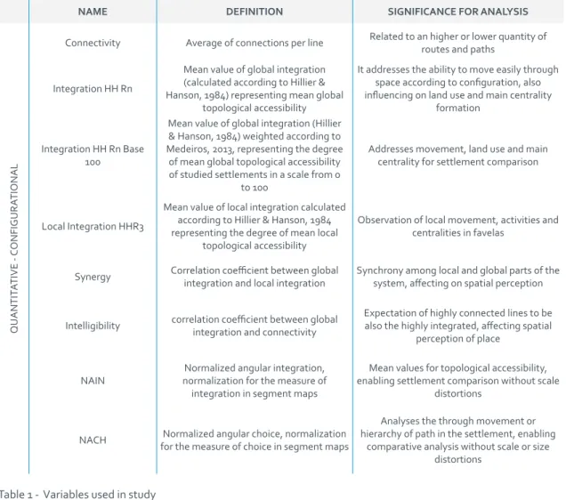
The studied sample of favelas was identified through a set of configurational variables, presented in table 1. After individual analysis of the 25 variables, some measures were correlated in order to find data associations, contributing to the exploitation of what might be the spatial pattern present in favelas.
NAME DEFINITION SIGNIFICANCE FOR ANALYSIS IDENTIFICA TION Name -- --Country -- Location Geographic
Region (UNESCO) -- Location
QUALIT
ATIVE
Topography Flat slope, Moderate slope or Steep slope Context
Size Large, Medium or Small (according to kohlsdorf's procedures, 1996) Dimension
Position in urban context Inserted in continuous fabric, Peripheral, or Peripheral on hill Context Position of Integration
Core
Most integrated lines or topologically most accessible ones tend to be Internal,
Peripheral or Mixed Centrality
Form of Integration Core Linear, Deformed Wheel (Hillier & Hanson, 1984) or Mixed Centrality
QUNTIT
ATIVE - PHYSICAL
No of Lines Total of axial lines in each favela Dimension
Area Favela ́s area in km2 Dimension
Total Line Length Sum of all lines length in km Dimension Compactness A Reason between number of lines and area, in lines/km2 Density Compactness B Reason between total length and area, in km/km2 Density
Line Length Mean length of axes in linear representation Mean length in the street system No of Segments Total amount of segments in each favela Dimension
Total Segment Length (km) Sum of all segments in the favela, in km Dimension
Segment Compactness A Reason between number of segments and the area of the settlement, in segments/
km2 Density
Segment Compactness B Reason between total segment length and the area, in km/km2 Density
Segment Length (m) Mean length of segments in the segment map Mean block’s size
No of Segments/No of Axial
Lines Reason between the number of segments and number of axial lines in each favela
Level of orthogonality: an higher number reveals orthogonal tendency (much more segments than axes) a smaller number reveals
NAME DEFINITION SIGNIFICANCE FOR ANALYSIS
QUANTIT
ATIVE -
CONFIGURA
TIONAL
Connectivity Average of connections per line Related to an higher or lower quantity of routes and paths
Integration HH Rn
Mean value of global integration (calculated according to Hillier & Hanson, 1984) representing mean global
topological accessibility
It addresses the ability to move easily through space according to configuration, also influencing on land use and main centrality
formation
Integration HH Rn Base 100
Mean value of global integration (Hillier & Hanson, 1984) weighted according to Medeiros, 2013, representing the degree
of mean global topological accessibility of studied settlements in a scale from 0
to 100
Addresses movement, land use and main centrality for settlement comparison
Local Integration HHR3
Mean value of local integration calculated according to Hillier & Hanson, 1984 representing the degree of mean local
topological accessibility
Observation of local movement, activities and centralities in favelas
Synergy Correlation coefficient between global integration and local integration Synchrony among local and global parts of the system, affecting on spatial perception
Intelligibility correlation coefficient between global integration and connectivity Expectation of highly connected lines to be also the highly integrated, affecting spatial perception of place
NAIN normalization for the measure of Normalized angular integration, integration in segment maps
Mean values for topological accessibility, enabling settlement comparison without scale
distortions
NACH for the measure of choice in segment mapsNormalized angular choice, normalization
Analyses the through movement or hierarchy of path in the settlement, enabling
comparative analysis without scale or size distortions
The selected settlements are part of a larger database that has been built along a PhD developing research. The analysed maps were drawn through free satellite images accessed from GIS platform QGIS©, and processed in Depthmap© for the calculus of configurational measures.
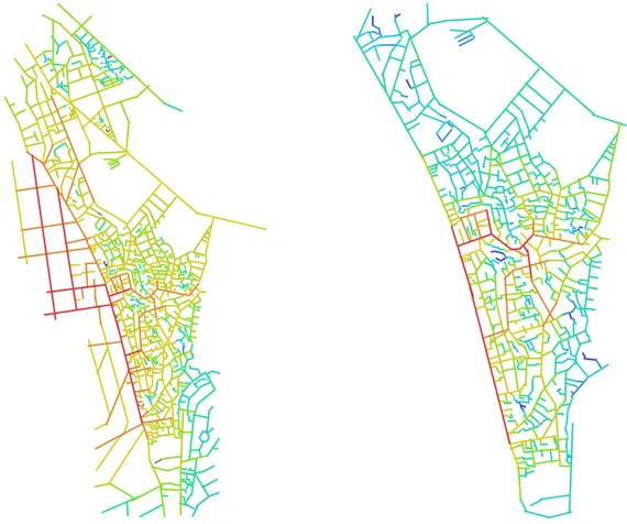
In terms of favela representation, it was chosen to draw only its informal structure, which means that all maps are represented disconnected from the remaining urban fabric. Taking into account the aim of analysing the internal structure of the favelas, the edge effect (weighting factor when analysing a small fragmented part of a larger system, according to Medeiros, 2013) had to be disregarded. This happens due to the extreme difference between favela organic structure and the surrounding city grid. As shown in figure 1, the experiment of representing favela following the common procedures – considering the edge effect – as well as only its structure – without outer connections –, resulted in some differences that seemed relevant for the analysis. As it is possible to observe in first situation, centrality is pulled towards the city grid while the purpose of research is to analyse and infer about the internal structure of favela. The reading of internal relations is much more relevant for addressing the research question, and that the larger surrounding grids might negatively affect such observation, so this methodological change had to be made. Also, due to its nature and organizing process, favela is in some way denied and denies the evolving city, this meaning a fragile connection between the surrounding and internal networks that explains the structural differences and peculiar method for addressing it.
Figure 1 - Experiment of representing a favela - Heliópolis (São Paulo) - with edge effect (left) and without it (right) in order to choose the best procedure for observing favela’s internal structure.
3. RESULTS AND DISCUSSION
3.1 PHYSICAL STRUCTURE AND ACCESSIBILITY
The following results explore the research question aiming to identify a pattern in the analysed sample of favelas. For a comparative overview, the obtained data is confronted with measures from 44 Brazilian cities investigated by Medeiros (2013). Also, mean values are highlighted to approach and verify the diversity in the settlement selection.
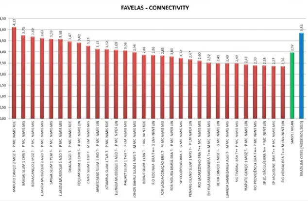
Following the bases of topological accessibility, the investigation of relational dynamic in favela happens from evaluating the paths network interdependencies. Preliminarily it seems important to explore connectivity (Figure 2), which, by the reading of axial maps, represents the average count of connections in each street of a given system. There is a great diversity of results, the analysed group contains values up to 4,0, superior to the 3,86 of Brazilian cities in general (Medeiros, 2013). Nevertheless, the mean value stays at 2,97, pointing out that these settlements have a lower amount of connections and therefore a smaller quantity of routes and paths possibilities. In the absence of some mitigating features, this seems to promote a labyrinthine character in space associated to its highly-fragmented structure.
Figure 2 – Mean connectivity
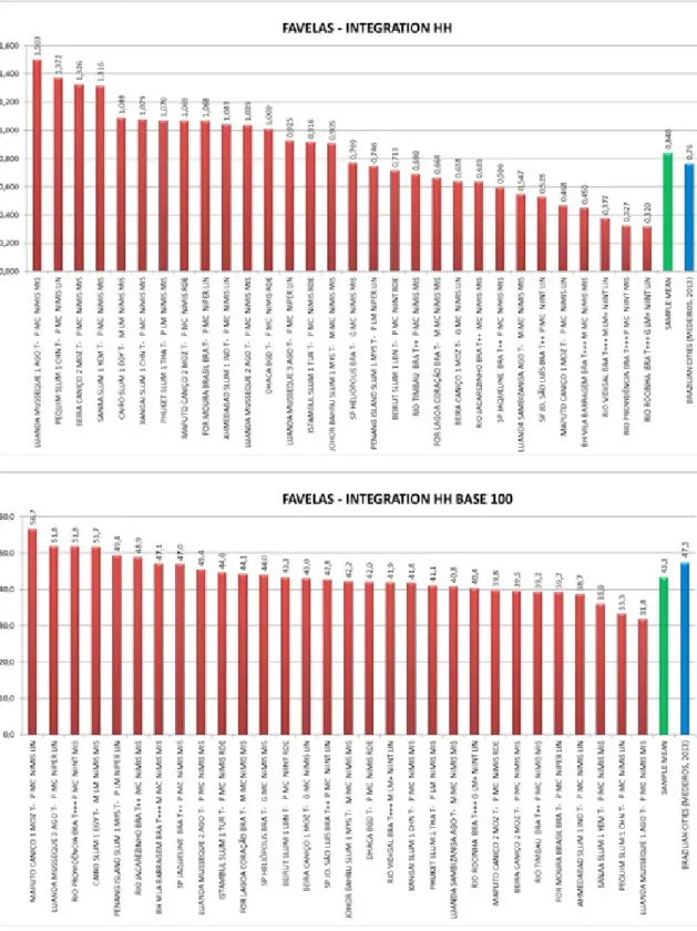
The commitment to interdependency relations results in associating the lower values of connectivity with favela´s organic character. Here, however, a relevant fact emerges. The mean value for integration HH in favelas (figure 3) (0,840) – representing the accessibility levels in paths network, weighted in a way that systems size will not influence the results – is superior to the one of Brazilian cities (0,764). One believes that this might occur due to the patchwork pattern recognized in Brazilian urban systems (Medeiros, 2013) and also due to the fact that local-global relations seem more efficient in favelas (cf. Figure 8 to synergy and intelligibility values). Although favela presents a better configurational performance, such characteristic does not mean that it might be already considered positively. Both present structural issues to understand, either related to homogeneity or fragmentation. Anyway, opposing to a negative established perspective, there seems to be a set of positive configurational relations in favela needing further investigation.
A slight inversion can be found in integration measures when converted to base 100 normalization (figure 3). In this case, when the distance between the mean value and poles is evaluated (all cases are converted to fit a range of minimum 0 and maximum 100) it becomes clear that hierarchy is higher in favelas than in the Brazilian cities sample (Medeiros, 2013): 43,3 in favelas and 47,3 in Brazilian cities. Such perspective points out to a greater level of segregation in favelas, once the topological distance between the integration extreme (integration core) and the mean is higher than in the observed cities. This results in a much-closed urban space which can be related to favela’s endogenous character.
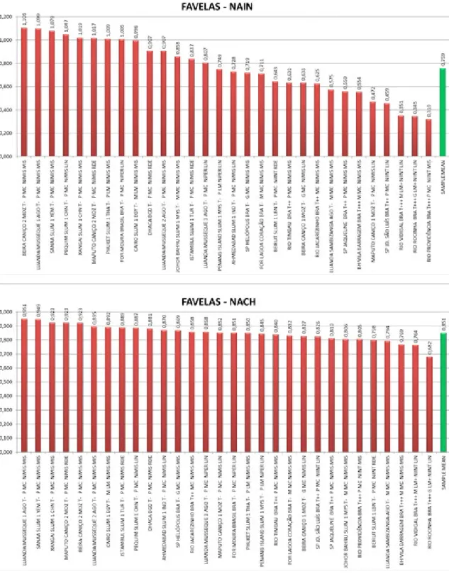
More refined accessibility measures can be extracted from segment maps and evaluated through angular differentiations in linear models. Considering that integration measures reflect topological accessibility (centralities and peripheries) and choice comprehends the most used paths (road hierarchy), NAIN and NACH represent normalized weighting to both (figure 4). A systems hierarchy tends to be better defined (consisting in efficient through-movement) if a higher NACH value is presented, whilst potential accessibility is better distributed (efficient to-movement) with a higher NAIN value. Even though this part of analysis has no comparison to Brazilian cities, findings suggest that topography plays a significant role in the type of settlement and therefore the established urban grid. It seems evident to both cases that more connected/regular settlements are located in the graphics superior poles.
The relevant cases of bigger levels of connectivity (figure 2), NAIN and NACH (figure 4) are Caniço 02 in Beira, Musseque 01 in Luanda, Favela 01 in Sanaa, Favela 01 in Beijing and Shanghai and Caniço 02 in Maputo. On the opposite side, characterized with low connectivity, higher irregularity and also lower NAIN and NACH are found Brazilian settlements mostly, such as Providência, Vidigal, Jardim de São Luís and Rocinha which represents a recurrent scenario of steep slope type of settlement. Nevertheless, Rocinha seems to be a peculiar situation once it presents a medium value for connectivity (2,86 in 2,97 of global mean) and the second smaller NAIN. This might be related to the intensity of topography and the large and complex scale of 8,453 lines system.
3.2 CONFIGURATION AND TOPOGRAPHY: DISPERSION AND ASSOCIATION ANALYSIS
The following dispersion analysis confronts connectivity, integration, NAIN and NACH values with the qualitative categories world region and topography (figure 05). Two main and interdependent tendencies stand out: (1) Latin-American settlements (represented here by Brazilian favelas) have the worst performance, being located at the graphics bottom. This result might be produced by the recurrent steep slope settling of favelas in Brazil and the consequent results mentioned above. Either way, independently of geographical location it is observable that (2) places with accentuated slopes have lower levels of accessibility. This reinforces the relevant role played by topography over the type of urban grid generated in space. Flat urban structures show tendency to be more accessible than sloping ones.
Figure 5 – Dispersion graphics associating: (a) connectivity and integration Rn HH with geographical location (top. left), (b) connectivity and NAIN with geographical location (top, right), (c) NACH and NAIN with geographical location (bottom, left), and (d) NACH and NAIN with topography (bottom, right).
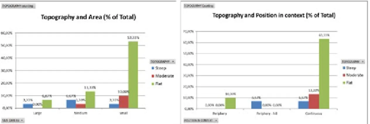
Despite the diversity of existing scenarios, the relation between topography and favela is strongly integrated into Brazilian urban imaginary once such spaces are deeply associated with steep areas – morros. Nevertheless, the association of topography with area (figure 6) reveals that favelas in flat sites are the most common situation in all size categories (large, medium and small). Most settlements, it seems, are located where occupation process might be facilitated in terms of acclivity, notwithstanding the common environmental issues of such areas (floodplains, swamps, lowlands, and so on).
A similar tendency is shown in the association between topography and position in urban context (figure 6). Favelas located in continuous urban fabric prevail to all others, and those are commonly situated in flat areas. The same happens to the cases in peripheral areas, with exception of those on hill situation.
Figure 6 - Variables association: (a) topography and area (left) e (b) topography and position in urban context (right).
Figure 7 – Variables association: (a) topography and integration core form (left) e (b) topography integration core position (right).
Topography also seems to affect the form and position of integration core (figure 7). The ICs recognized as deformed wheels are only located in flat areas, while the remaining – linear and mixed – can be found in all three topographical categories. This opens discussion about consolidation processes in top of hill favelas. Would a deformed wheel structure develop and emerge even in a restricted relief situation, or do physical constraints prevent such consolidation process to develop? This might explain about favela’s weak relations to surroundings when located in extreme relief areas.
Nevertheless, internal integration cores mostly happen in structures located at steep sloped areas (figure 7), reinforcing the idea of favela as an almost autonomous system when located in such conditions. The articulator role of external accesses in favela seems to be reduced when no central lines connect to it, once the structure is not sewing to surroundings. This might be related to the configurational process for ghetto formation.
Measures of topological accessibility, when confronted with topography, can express how much physical constraints do affect on among parts articulation. Previous studies, such as Medeiros (2013) pointed out, looking at colonial cities, that relief tend to result in more fragmented systems once it produces a network of mostly “T” shaped paths. This means that routes usually end right after connecting, without crossing. Oppositely, in flatter areas, city structure seems to progress towards orthogonality, presenting a prevalence of “X” paths and intersecting a larger number of streets. The main effect on accessibility relations in the first situation is that global paths are critical for connecting central and peripheral parts, otherwise movement and route options will be restricted. In the second situation, when connections are maximized there will be more path options, causing smaller polarization within accessibility extreme conditions.
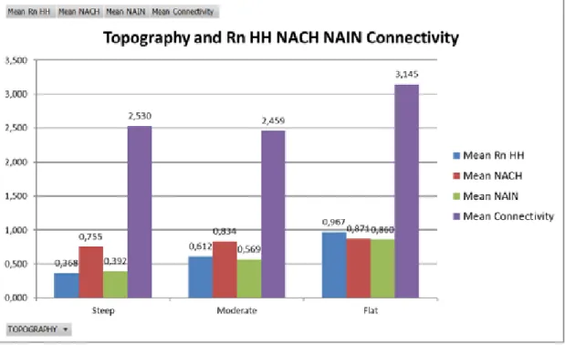
The obtained results in figure 8 suggest the extent to which topography restricts accessibility. Favelas located in flat areas show higher mean connectivity values (3,15), while in steep or moderate sloped areas the mean decreases below 3 (the global mean is 2,97) and Brazilian cities investigated by Medeiros (2013) reach to 3,86 (figure 8).
Figure 8 – Variables association: topography, integration Rn HH, NACH, NAIN and connectivity.
The performance of integration HH Rn, NAIN and NACH measures reinforces the tendency. However here, the more accentuated, the lower the value is and the flatter, the higher it becomes. This means that topography results in a set of constraints for the implementation process that can compromise topological accessibility, as seen before.
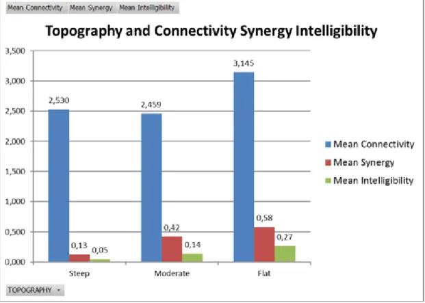
It is worth clarifying that mean integration HH of favelas (0,840) is higher than that of Brazilian cities (0,764) (as seen in figure 03). The negative factor impacting on the performance of these cities – the worst in a comparative study for cities worldwide (Medeiros, 2013) – is the so-called patchwork pattern. Brazilian city is generically regular but composed over adjacent distinct grids from different neighbourhoods or city zones, lacking global connections to coherently articulate the parts. In the case of favelas, despite the impact of topography, there is a clear spatial pattern distributed in all system, generating higher homogeneity and also better hierarchy. And perhaps, that is the source of favela´s better performance. Still, it seems critical to consider a scaling factor when analysing the results (even though integration values are already normalized in order to guarantee comparison): smaller systems commonly have higher accessibility values. While Brazilian cities have a mean of 7,882 lines, favelas reach only 834. It is also important to verify some recurrent pattern relating topography to spatial perception matters (figure 09). The more accentuated the site, the more compromised are the relations between local and global parts of the system read through intelligibility and synergy measures. The first expressing the expectation of most connected lines to be also the most integrated ones (integration HH), and the second expresses the prediction of globally most integrated lines to be also the most integrated locally (the global dynamic expressing itself on local dynamic). Results present that favelas in flat areas are easier to read: intelligibility and synergy values are higher in those cases, while smaller values can be found in steep sloped systems. It seems to be the case that they can be easily recognizable from outside, due to its outstanding position, although this physical condition accentuates the labyrinthic character of its constituent paths network.
Figure 9 - Variables association: topography, connectivity, synergy e intelligibility.
Comparing the obtained values to the values of Brazilian cities, available from Medeiros (2013), once again the patchwork pattern becomes relevant (figure 10). Despite problematic issues in urban systems like favelas, there seems to be a better spatial perception performance than in the urban systems of Brazil. This seems to be simultaneously product of size and among parts articulation, due to urban fragmentation. Although often related to labyrinthic scenarios, favelas seem to keep better internal relations due to a clear hierarchy among main accesses or central lines in the integration core and the alleys and paths integrating the remaining system. Though both cases present low values, favela´s intelligibility is 22% while it is only 15% for Brazilian cities. Moreover, mean synergy in favelas is 50% opposing to the 36% of cities.
4. CONCLUSIONS
As an exploratory research, this paper aimed to identify the spatial structure of favela among recurrent spontaneous urban practices. Discussions were based on the following research question: “Is there a spatial pattern for favelas?”. Findings suggest a set of tendencies for a better understanding of spatial patterns in those settlements, referring to topological characterization and topographic relations:
• Topography constraints favela´s accessibility. Settlements in flatter areas have higher mean connectivity values, when slightly sloped or steep sloped (without expressive distinction) mean values fall down. Performances of Integration HH Rn, NAIN and NACH reinforce the tendency. However here, the more accentuated, the lower the value is and the flatter, the higher it becomes.
• As for perception matters, it is also possible to find a recurrent pattern in relation to topography. Global and local relations from synergy and intelligibility tend to be more compromised as more accentuated the place’s topography seems to be. Despite that, spatial perception is better in favela than in Brazilian cities. This seems to be simultaneously product of size and among parts articulation, due to urban fragmentation. Although often related to labyrinthic scenarios, favelas seem to keep better configurational relationships due to a clear hierarchy among main accesses or central lines in the integration core and the alleys and paths integrating the remaining system.
• The mean values for topological accessibility are higher in favela than in cities (cf. Medeiros, 2013). Such performance seems to result from, at first, the patchwork pattern present in Brazilian cities, and secondly, from the presence of more efficient local/global relations in favelas than in those cities. Such characteristic does not mean that it is already something considered positively. Both present structural issues to understand, either related to homogeneity or fragmentation.
• Spatial hierarchy is clearer in favela than in cities which can be related to its endogenous and complex character, possibly resulting in a much closer urban space.
The synthesis of findings assumes a spatial pattern for favela:
• Compact and dense structure, due to a maximization need of land use, even in flat areas (predominant);
• Predominance of short streets and irregular urban blocks;
• Resulting into meaningful fragmentation and discontinuity, affecting mainly on the labyrinthic perception of space;
• Accentuated spatial hierarchy (minimum and maximum poles being more distant, resulting in reinforced segregation);
• Topological performance better than Brazilian cities.
Such characteristics, specifically this last point reinforces to the need of acknowledging furthermore the existing relations in favela that could be adopted to refine the configurational performance of cities. Nevertheless, topography is critical to the understanding of favela’s performance. The more accentuated the more fragmented, labyrinthic and endogenous. Oppositely, flat settlement areas present a tendency to better articulate favela with the surroundings, resulting in a softer in-and-out transition.
As it seems, the spatial structure of favela experiences, in a very short period of time since its implementation, a transforming process that city took decades or centuries to achieve. Due to its occupation restrictions, the spatial organizing rules are dynamic and can be observed in diverse development stages. The self-organizing and emergent processes of favela provide
REFERENCES
Alexander, C. (1979), The timeless way of building, Oxford University Press, London.
Capra, F. (2003), A teia da vida: uma nova compreensão científica dos sistemas vivos, Pensamento-Cultrix, São Paulo. Davis, M. (2007), Planet of slums, Verso, London.
Guerreiro, M. (2010), Urbanismo orgânico e a ordem implícita, PhD thesis, ISCTE-IUL Escola de Tecnologias e Arquitectura.
Hillier, B. (1996), Space is the machine, Cambridge University Press, London. Hillier, B. and Hanson, J. (1984), The social logic of space, CUP, London. Holanda, F. (2002), O espaço de exceção, EdUnB, Brasília.
Holanda, F. (2012), Ordem & desordem: arquitetura & vida social, FRBH, Brasília.
Jonhson, S. (2003), Emergência. A vida integrada de formigas, cérebros, cidades e softwares, Jorge Zahar Editor Ltda, Rio de Janeiro.
Kohlsdorf, M. (1996), Apreensão da forma urbana, EdUnB, Brasília.
Medeiros, V. (2013), Urbis Brasiliae: o labirinto das cidades brasileiras, EdUnB, Brasília.
Salingaros, N. (2010), Twelve lectures on architecture - algorithmic sustainable design, Umbau-Verlag, Solingen. Salingaros, N. (1998), A Teoria da Teia Urbana, Journal of Urban Design, Volume 3, p. 53-71. Taylor & Francis Limited. Salingaros, N. et al. (2006), Habitação social na América Latina: uma metodologia para utilizar processos de
autoorganização, CIAHS, Florianópolis.
Sobreira, F. (2002), A lógica da diversidade: complexidade e dinâmica em assentamentos espontâneos, PhD thesis, Programa de Pós-Graduação em Desenvolvimento Urbano, Universidade Federal de Pernambuco, Recife.