Understanding and mapping local conflicts related to protected areas in small islands: a case study of the Azores archipelago.
Chiara Bragagnolo
Federal University of Alagoas (UFAL), Maceió, Brazil chiara.bragagnolo@yahoo.com.br
Margarida Pereira
e-GEO Research Centre, Universidade Nova de Lisboa, Lisboa, Portugal ma.pereira@fcsh.unl.pt
Kiat Ng
Centre for Ecology, Evolution and Environmental Changes, Universidade de Lisboa, Portugal kiat@uac.pt
and
Helena Calado
CIBIO Research Centre, University of the Azores, Ponta Delgada, Portugal calado@uac.pt
ABSTRACT: Establishing Protected Areas (PAs) is considered one of the most appropriate
ways to conserve nature and cultural landscapes. However, conservation constraints can generate social conflicts, especially at a local level. In small islands (SIs), local conflicts may escalate due to an increase in competition for limited space and resources. Pico island in the Azores Archipelago (Portugal), part of the Outermost European region, was considered a good case to study conservation-development conflicts due to the amount of designated protected land (> 35% of its surface) and the approval of a new Azorean PA network in 2007. This paper presents a new approach to understanding and mapping local conflicts within PAs in SIs by integrating qualitative data and spatially explicit information. This research takes stock of the benefits, needs and constraints related to Pico Natural Park as perceived by local stakeholders through face-to-face semi-structured interviews; it subsequently identifies and transposes the conflicts distilled from stakeholder discourse into spatially representative visual maps via GIS. Research outcomes show that PAs are perceived mainly as constraints to local development, showing inconsistency between local expectations and regional conservation policy. This highlights the importance of including public participation processes prior to any implementation of conservation strategies. The proposed method provides a springboard towards effective conflict management for PAs on Pico island, showing a relatively low-cost and straightforward approach to minimising future local conflicts which could be adapted to other similar Outermost European regions and SIs.
Keywords: conservation-development conflict, GIS, participatory approach, biodiversity conservation, Outermost European regions, protected areas, small islands, stakeholder analysis
Introduction
Protected Areas (PAs) are globally considered the most important instrument for conserving biodiversity and preserving cultural landscapes (Lockwood et al., 2006; Jepson et al., 2011; Watson et al., 2014). Since the first area set aside for nature protection in 1872 (the U.S. Yellowstone National Park), the concept of PAs has changed greatly, reflecting rapid social changes (Ervin et al., 2010). Although PAs have always been accepted worldwide as one of the main tools to protect nature, their role in conserving biodiversity only became explicit in 1990s when the International Union for Conservation of Nature (IUCN) defined a protected area as “an area of land and/or sea especially dedicated to the protection and maintenance of biological diversity, and of natural and associated cultural resources, and managed through legal or other effective means” (IUCN, 1994). Later, the concept was expanded, extending the function of PAs from conservation tout court (supplying habitat for wildlife species) to multi-purpose that encompasses maintenance of ecosystem functioning and support of local livelihood and economy (Watson et al., 2014). This led to redefining a PA as “a clearly defined geographical space, recognised, dedicated and managed, through legal or other effective means, to achieve the long-term conservation of nature with associated ecosystem services and cultural values” (Dudley, 2008). This new definition reflected a more anthropocentric view of PAs, emphasizing their role in supporting human life and well-being, and delivering multiple ecosystem services (Watson et al., 2014). Consequently, natural systems (and PAs) can no longer be treated as separate from human systems (Corlett, 2015). The role of local communities has, therefore, moved from passive to a more active participation and engagement in conservation activities (Ervin et al., 2010). However, in this context, conservation-development conflicts are more likely to emerge as multiple stakeholders may attach their different interests, values, power, perceptions and goals to PAs (Yasmi et al., 2006). By “stakeholders” we refer to individuals or groups who affect or are affected by certain decisions and actions taken by the organization (Freeman, 1984).
The establishment of a PA is considered one of the most representative examples of conflict between individual needs (i.e. short-term and local) and collective interests (i.e. long-term and global) (Bonaiuto et al., 2002). As defined by Moore (1996) and Kwaku Kyem (2004), a conflict is a misalignment of interests, values or actions between individuals or social groups. Of note, the nature and the magnitude of conflicts as well as the way in which people and communities respond to them may vary greatly over time and place, reflecting specific spatial and temporal contextual aspects (i.e. wealth, social status, power) (Paavola, 2004). From a psychological point of view, although different individuals may endorse the same values, different priorities may result in diverging preferences, choices or behaviours (Gifford & Sussman, 2012). Thus, the interests that sustain a conflict generally reflect opposite needs, desires and beliefs underlining the positions of individuals or social groups (Moore, 1996; DeChurch & Marks, 2001; Kriesberg, 2007).
resources, land use pressures, and control over decision processes (Lewis, 1996; West & Brockington, 2006). However, disputes and disagreements over the use and protection of natural resources within communities are frequent and not necessarily negative (Castro & Nielsen, 2003). To manage conflicts within PAs, a participatory and inclusive approach involving and engaging stakeholders in PAs has been advocated as a proactive way of transforming conservation-development conflicts into opportunities (Borrini-Feyerabend, 1996; Indrawan et al., 2013). The importance of setting the groundwork of stakeholder participation early and throughout a planning process has been underscored by the philosophy of “empowerment, equity, trust and learning” (Reed, 2008). Similarly, Van Assche et al (2012) remind us that the impact and success of planning relies on effective communication, dissemination and public acceptance of “concepts, strategies, forms and materialities”, while Van Assche et al (2014) reflected on power in/on/of planning systems and deliberated that co-evolution of the planning realm and society is a consequence of the positionality of planning. Thus, during recent years, planning discourse has started to focus more on conflict resolution, emphasizing the importance of negotiation and mediation instruments based on communication and collaboration in contrast with conventional litigation tools which disregard the integration of interested groups into the decision-making processes (Sidaway, 2005).
By incorporating local perspectives early in the PA decision-making process, conflicts associated with conservation can be better identified, negative trade-offs can be minimized and public awareness about PAs can be raised (Lewis, 1996; Jamal, 2004). Most of the instruments and mechanisms to minimize conservation-development conflicts focus on: providing more equal incentives mitigating perceived losses (e.g. tourism revenue sharing) (Wynberg & Hauck, 2014); assessing and demonstrating the multiple values of conservation through educational projects (Thomassin et al., 2010; Leisher et al., 2012); and including local people in decision-making processes, eventually implementing co-management systems (Gilman, 1997; De Pourcq et al., 2015). However, regardless of the chosen strategy, relevant stakeholders need to be systematically included throughout the process (Reed, 2008). To this end, stakeholder analysis has demonstrated to be a useful tool in identifying positions of actors and their relationships as well as assessing relative powers and gaining knowledge about the social context in which conservation policies are being enforced (Rastogi et al., 2010). Reed et al (2009) defines stakeholder analysis as a multi-phase process where: (i) social and natural aspects of a phenomenon affecting a decision or action are defined, and (ii) individuals, groups or organizations who are affected by these aspects are identified and, then, (iii) prioritized in order to be part of the decision-making process. As presented by Andrade & Rhodes’s (2012) work on determining the main criteria for better compliance with PA conservation policies, the level of local community participation in the PA decision-making process was the only variable that was significantly correlated with the compliance level amongst the other six criteria considered. Drawing on their results suggests that the main strategy for assuring PA integrity lies in greater involvement of local communities in PA management (Andrade & Rhodes, 2012).
(Calado et al., 2007; Lagabrielle et al., 2009; Niles & Baldacchino, 2011). According to Brown and Raymond (2014), one of the most common consequences of land scarcity is the occurrence of land-use conflicts. Since most terrestrial PAs are pieces of land set aside and/or regulated for conserving biodiversity, land-use conflicts may emerge as a consequence of divergent interests on that land (e.g. development vs. conservation). A land-use conflict “occurs whenever land-use stakeholders (i.e. conflict parties) have incompatible interests related to certain land-use units (i.e. geographical component)” (von der Dunk et al., 2011). Thus, understanding social positions and mapping the spatial distribution of areas with different conflict levels could provide valuable information for conservation planning, facilitating communication and collaboration among decision-makers and stakeholders (Kwaku Kyem, 2004). With spatial representation, conservation-development conflict zones and low-conflict spatial options can be better identified and visualized, and alternative plausible spatial options, e.g. biodiversity conservation vs. rural development, could be effectively discussed and assessed without losing sight of the consequences to the other areas.
Among others, participatory mapping based on the visualization of conflicting areas has shown to be a useful and simple tool to anticipate and identify areas of potential land-use conflicts, facilitating conflict resolution and communication among decision-makers and stakeholders (Harris & Weiner, 1998; Kwaku Kyem, 2004; Brown and Raymond, 2014). Studies have demonstrated that the most influential factors on stakeholders’ attitudes towards PA are their cost-benefit perception of the park, their involvement in the park establishment and their previous experiences with the organizing institutions (Thuy et al., 2011; Nastran, 2015). According to Rauschmayer and Wittmer (2006), by combining deliberative and analytical methods, environmental conflicts can be more effectively resolved. In this context, many researchers suggested the use of Multi Criteria Analysis (MCA) as a potentially practical approach to dealing with conservation conflicts and/or assessing the trade-offs associated with alternative interventions to manage conflicts (Davies et al., 2013). Moreover, MCA has been frequently integrated with GIS, providing a useful tool to, for example, map environmental disputes associated with establishing PAs in coastal areas (Brody et al., 2004), identify potential sites for tourism development (Wong & Fung, 2015), develop a zoning scheme for supporting marine protected areas (MPAs) planning in a context with scarce resources (Habtemariam & Fang, 2016), support the evaluation for site selection of offshore marine fish farm (Dapueto et al., 2015), suggest specific zoning strategies to assist the establishment of MPAs in Taiwan (Lu et al., 2014), support PAs zoning (Geneletti & van Duren, 2008), among others.
However, it is broadly recognized that these techniques may require resources and skills that may not always be available or accessible (Rauschmayer & Wittmer, 2006). In addition, the application of complex models into participatory processes has been cautioned against, since it may increase the “black box” effect, ultimately decreasing transparency and public trust (Voinov & Bousquet, 2010). Further, developing participatory models can be very time-consuming, and in most cases decision-makers need quick and decipherable information. These complex approaches are challenging to execute in locations with limited financial and human resources such as in SIs. Consequently, a simple spatial tool that is achievable within limited time, financial and human resources constraints is proposed as a way of supporting conflict management in the context of PAs in SIs. This proposed method combines a participatory approach and GIS to visually map conflict levels and types across an island-wide PA network. This two-step method entails: 1) participatory approach: local stakeholder selection and semi-structured interviews with identified and available stakeholders; and 2) GIS: using available spatial data, this transposes the levels and types of conflicts determined in the first-step into spatially representative maps. Using Pico island as a case study, this research was undertaken within the SmartParks project, which focused on developing a novel approach towards supporting PA management in SIs. In this context, “participation” refers broadly to the interaction process with stakeholders. Using the influential “ladder of citizen participation” described by Arnstein (1969), the level of participation applied in this case study corresponds to level 4 - stakeholder consultation.
which supports directly the management of internal competitions over land and resources scarcity and indirectly spatial planning policies could be easily adapted to other similar SI contexts.
Study area
Location and geography
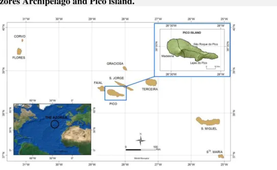
The Azores archipelago, an Autonomous region of Portugal, is an Outermost European region located in the North Atlantic about 1500 km from the west coast of the European continent and 4000 km from the North American subcontinent. It consists of nine inhabited islands of volcanic origin, grouped into three geographical clusters (Morton et al., 1998). Pico island belongs to the Central group and it is the second largest island of the archipelago with an area of 447 km2 and 152 km of coastline (Figure 1). Its western part is occupied by a homonymous volcano reaching an altitude of 2,351 meters (the highest peak in Portugal) and which gives it the name of “Mountain Island” (Calado et al., 2014). This island has a temperate oceanic climate with an annual temperature of 17 degrees at sea level, and high relative humidity and increasing rainfall with altitude (1,500 to 3,000 mm/m2) (Cruz, 2003).
Figure 1: The Azores Archipelago and Pico island.
Pico island has approximately 14,150 residents according to the most recent regional census data taken in 2011 (INE, 2011). Natural areas, pastures and crops dominate the island’s core, while urban areas, harbours and infrastructures are mainly concentrated along the coast. The local economy relies mainly on agriculture. However, ecotourism is a growing sector with Pico mountain being one of its main attractions for both national and international visitors (Bentz et al., 2013). The increase in tourists subsequently led to an establishment of a daily threshold limit (carrying capacity: 160 persons) to control the number of visitors to the peak, particularly during the summer season.
habitats (e.g. Laurifolia Humid Forest) and species such as Erica azorica, Arceuthobium azoricum and Spergularia azorica (Petit & Prudent, 2008). However, in recent decades the entire Archipelago has suffered from a reduction in the areas of natural vegetation by around 50% as a result of the conversion to pastures (Dias et al., 2005). Pastures and cattle grazing have resulted in serious changes in ecosystems, especially in mountain Azorean habitats, threatening nature conservation (Dias and Melo, 2010). In Pico, animal grazing is not an exception even within PAs, where the conversion of natural areas to other land uses is legally prohibited.
In addition to Pico’s rich natural capital, its traditional man-made viticulture heritage, established since the arrival of its first settlers in the 15th century, contributes significantly to the shaping of the island’s landscape character (UNESCO, 2004). The viticulture landscape comprises thousands of contiguous and rectangular plots known as currais that are separated by walls built of local volcanic rocks (Calado et al., 2016). In 2004, the Landscape of the Pico island Vineyard Culture was designated as a UNESCO world heritage site with the goal of protecting the cultural landscape and tackling the issue of vineyard abandonment. The site includes both a relict cultural landscape (areas of abandoned stone-walled enclosures) and a living and working landscape (areas where wine production continues to take place). Most of the deterioration of the abandoned currais results from disuse, while certain invasive plants species have colonised many of these enclosures. The integrity of this unique landscape is threatened by the construction and future development of new buildings with poor visual quality standards (UNESCO, 2004).
Protected Areas regional policy and governance
Since the beginning of the nineties, nature conservation in the Azores has changed greatly reflecting the evolution of international and national conservation policies. The first conservation effort in the Azores was the creation of several set-aside reserves to protect nature and forest (the first natural reserve established in the region dates back to 1972) (DL 78/72). Later, there was a first attempt to create a PA regional network as a consequence of the establishment of a PA network at a national level (DL 19/93). Thus, a Regional Decree (DLR 21/93/A) establishing the first PA network joined previously designated forest and natural reserves into a unique network. Then, in 2004, the Natura 2000 sites as well as all the important areas designated by international agreements or conventions were further included (i.e. IBA, Ramsar sites, etc.) (DLR 14/2004/A). Furthermore, ad-hoc legislation was elaborated to protect regional endemic species according to the Bern Convention and the EU-Habitat Directive. Nonetheless, this ‘puzzle’ of PAs was not meeting its objectives due to the fragmented nature of the designation criteria and objectives, the poor implementation of conservation strategies, and the scarce coordination of multiple authorities in charge of conservation (Calado, 2008; Calado et al., 2009). This led the regional government to design a more coherent network of PAs at a regional scale. Thus, in 2007 a regional legal framework introduced a new PA system which sets the groundwork for PA planning, management and administration (DLR, 2007; DLR, 2012). The most important changes refer to:
management criteria and objectives were different and inconsistent. The IUCN categories were adopted (Dudley, 2008)1, establishing goals for each PA and related human activities;
The creation and establishment of nine island Parks (one for each small island) and an offshore Marine Park (the Azores Marine Park – from 12 to 200 miles). At the core of the PA network is the concept of island natural park (INP) which integrates terrestrial and coastal (up to 12 miles) PAs of each island. This integration has been considered an innovative strategy for costal conservation and planning, requiring cohesion between Coastal Management Plans (a key planning instrument for small islands) and INPs (Calado et al., 2009);
A new planning instrument and authority responsible for the management of each Park (hereafter referred to as the Park Authority) were introduced. The INP plan defines the zoning regulations of each PA and integrates the objectives and norms of other relevant plans, while the Park Authority is composed of a management and a consultative board. The former is an executive board formed by a group of selected delegates nominated by the Regional Environmental Authority together with the local authorities, i.e. municipalities. The latter serves as a consultative function and can include regional and local stakeholders, both public and private. Accordingly, the regional conservation policy defined the INP as the mainunit for the management of each island and the establishing of the INP plan and the Park Authority as its main management tools (DLR, 2007; DLR, 2012). This new system was anticipated to play a key role not only in protecting nature but in contributing to more effective sustainable management of each island, facilitating the integration of different planning instruments, anticipating conservation-development conflicts and supporting more participatory decision-making (Calado et al., 2009).
Management of PAs in Pico island
The Pico INP (hereafter also referred to as the Park) was subsequently established in 2008 (DLR 20/2008/A; a year after the approval of the regional PA network in 2007 (DLR 15/2007/A)). Pico INP integrates 22 PAs classified under IUCN categories (Dudley, 2008; Figure 2). The terrestrial part of the Park covers 35% of the island, which includes the Pico mountain and the central plateau with exceptional geological and ecological features, coastal sites important for the conservation of marine birds and the protection of the coastal-water resources, and the UNESCO site (Landscape of the Pico island Vineyard Culture). The Landscape of the Pico island Vineyard Culture was established in 2004 due to the unique
1 The IUCN protected area management categories are a global framework, recognized by the Convention on
landscape, consisting of thousands of small, contiguous, and rectangular plots (currais) separated by linear volcanic rocky walls (Calado et al., 2016). It covers about 30% of the coastal zone and has been included into the INP under IUCN category V: protected landscapes/seascapes.
Figure 2: The Pico INP classified using IUCN category.
The reclassification of PAs consistently defined goals and management objectives for each PA. For example, more than 5% of the island was classified as Strict Reserve (IUCN category I) in which human activities are restricted and no human intervention is permitted, and about 28% of the island was classified as Protected Landscape (IUCN category V) in which a high level of interaction with human activities is allowed and promoted to maintain or restore traditional management practices along with the natural systems with which they co-exist.
percentage reflects the importance of considering these regulations as likely drivers of conservation-development conflicts.
Methods and Results
To understand local conflicts and delineate conflicting areas, this work integrates both qualitative data and spatially explicit information. The analysis includes two phases: Phase 1 involves conducting a stakeholder analysis and identifying the perception of stakeholders towards the park, while Phase 2 focuses on translating the qualitative outcomes into spatial representation through the mapping of conflicting areas.
Stakeholder analysis
Local conflicts related to Pico INP were determined through a stakeholder analysis and a set of semi-structured interviews with key actors. In our work, stakeholder analysis was mainly used to explore the attitude towards the park and identify potentially conflicting interests and/or alliances among stakeholders. The analysis included:
Identification of key actors. By “key actors”, we refer to private or public organizations that may influence or may be affected by the decisions associated with the creation and management of INP. A first list of key actors was extracted from the yellow pages of Pico island, by selecting all public and private governmental and non-governmental organizations and/or associations having headquarters on the island. Then, stakeholders were selected based on three main criteria: legal nature (private and public), sector of interest (primary, secondary and tertiary) and area of action (land-use planning and management, nature conservation, business and economy, leisure and recreation, communication). Except for the tourism sector, we only considered leaders or heads, meaning people representing groups of individuals or members (i.e. heads of NGOs, leaders of associations, etc.). Among the governmental bodies, we included the 3 island municipalities and the Park Authority. From the non-governmental sector, we selected 3 environmental NGOs with headquarters on Pico island, and 9 local associations representing primary and secondary economic sectors (artisanal fishery, agriculture, dairy, wine production, and construction). In the absence of associations representing the interests of the tourism sector, we selected 9 micro enterprises (i.e. hotels, tourism entertainment, nautical sports, etc.). Additionally, we identified 3 associations related to tourism and recreation (i.e. tourist guides, recreational fishery and hunting, taxi-drivers). Finally, we selected 5 local media (radio and newspapers) as actors representing the communication sector.
Table 1: Classification of stakeholders.
Group Influence and importance
Park Authority (S1)
The actor with the greatest decision-making power with respect to nature conservation issues and Park management. However, since this authority has been recently introduced by the regional conservation policy, it can be largely exposed to the influence of those actors with longer decision-making power within the island, i.e. local authorities and powerful economic sectors.
Local authorities (S2-S4)
These represent the three municipalities of the island. Local governments play a strategic role in the Azores, being responsible for spatial planning and having leverage over most of land-use decisions. Moreover, they directly concur to the definition of several members of the Park Authority. Thus, understanding their influence on the Park (and Park Authority) is crucial for the long-term conservation of the island and the archipelago.
Local economy (S5-S14)
Representing the main economic sectors (wine and livestock farmers, dairy industry, traditional fishery, hotels, tour operators and tourist guides). Although this group of actors does not have a direct influence on the Park’s decisions, their interaction with natural resources and
landscape has results of great importance for Park management. The primary sector by definition makes direct use of natural resources, which frequently compete with conservation initiatives and PAs. This is particularly true for small island terrestrial PAs, considering their limited land. The secondary sector in Pico island mainly relies on the
transformation of primary products, generating food (e.g. meat and cheese) and wine and potentially exerting an increasing demand of land for production. The tourism sector strongly depends on nature
conservation as ecotourism represents one of the major businesses for the island (e.g. whale-watching, climbing, etc.).
Non-governmental organizations and
associations (S15-S19)
These are public organizations and associations actively engaged in leisure, cultural and environmental issues, including their dissemination by the media. They are crucial mediators between the Park and local people, influencing the perception and interests of the public.
questions asking interviewees to: (i) provide a general opinion about the INP and its boundaries; (ii) list park-related benefits and costs; and (iii) portray park-related needs.
Stakeholders’ Perspective
The results of interviews were collected, transcribed and analyzed through qualitative content analysis based on Bardin (1977). Accordingly, three matrices were built to support the analysis of the stakeholders’ perception: needs vs. actors, benefits vs. actors, and constraints vs. actors. Perception refers to park-related needs, benefits and costs as mentioned by each stakeholder. The results are summarized in Table 2.
The outcomes reflected two main positions towards the Park, namely actors with negative and positive attitudes. The negative attitudes mainly pertain to the Park size (N1 – reshaping PA boundaries) and restrictions on the local economy (N2 and N3 – need more flexible measures for ecotourism development; C9 – the Park constraints the development of ecotourism and related infrastructures). Actors with a more positive attitude indicate that the Park should be primarily a way of protecting nature and natural resources (N5, N6 and N7 – need to protect nature and better cope with human-conservation conflicts; B1 – the Park contributes to conservation).
Table 2: Needs, benefits and costs related to Pico INP as perceived by stakeholders.
ID Needs Stakeholders
N1
Reshaping PA boundaries. It refers to downsizing as several actors explicitly express the need to downsize PAs for economic purposes. Some of them further suggest finding a trade-off mechanism to permute pastures which are now under protection with other contiguous non-protected areas with a smaller economic value, avoiding downsizing PAs.
S2, S3, S8, S9, S10, S14, S17
N2 Redefining the carrying capacity of trails S11, S5, S15 N3 Increasing urban capacity within the UNESCO site S8, S10, S14 N4 Supporting the development of tourism (hotels, shops, etc.) S6, S5, S14 N5 Banning the enlargement of grazing areas S1, S15 N6 Coping with conservation-development conflicts S10, S18, S19
N7 Preserving biodiversity S1, S5, S13, S15
N8 Strengthening public participation S19
N9 Others (e.g. supporting wine production, providing fresh water, establishing a monitoring plan, etc.) S2, S3, S4, S10, S12, S16, S18
N10 None S7
ID Benefits
B1 Conservation of natural resources S5, S6, S11, S12, S18, S19 B2 Support for (eco)tourism development S1, S5, S6, S11, S12, S13,
S15, S16, S18, S19 B3 Improvement and enhancement of the island’s image S1, S5, S8, S16, S17 B4 Others (e.g. banning dangerous human activities, preserving landscape, etc.) S1, S8, S15, S18
B5 None S2, S3, S4, S7, S9, S10,
S14
ID Constraints
C1 Excess of protected land S6, S17
C2 Restrictions to local economy S2, S3, S8, S9, S16, S19
C3 Loss of incomes S9, S10
C4 Limitations on the enlargement of grazing S2, S3, S4
C5
Ineffective management of PAs (scarce surveillance, poor organization and administration, lack of infrastructures, etc.)
S5, S13, S14
C6 Excess of species protection (e.g. Urze) S1, S3, S8, S10, S17
C7 Increase of bureaucracy S5, S18
C8 Limited exploitation of the mountain S5
C9 Excess of building restrictions within the UNESCO site S2, S6, S10, S13, S14, S19 C10 Scarce involvement of local people (creation and
management of the Park)
S10, S18
C11 Others (e.g. hunting restrictions, lack of awareness, etc.) S9, S10, S16
Mapping conflicting zones
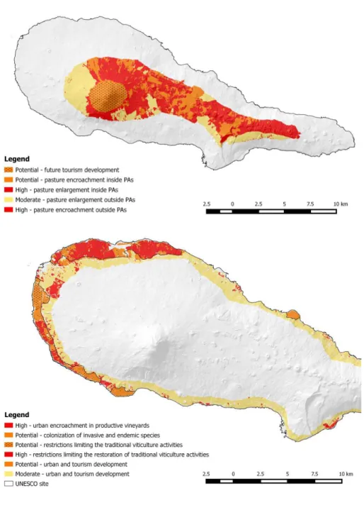
To generate the map of conflicts, we converted qualitative information obtained from the semi-structured interviews into spatial data. The outcomes of the qualitative analysis were primarily used to: (i) identify the most conflicting zones of the island (zones where conflicts in PAs are occurring or more likely to emerge), and (ii) scope the type and level of conflicts. Then, (iii) conflicts were mapped starting from three main data sources: an existing Land Use Cover map (LUC) of Pico; a simplified model of volcanic SIs applied to Pico; and the parks’ boundaries.
Identify conflicts
According to the stakeholders’ perception, PA-related conflicts were mainly concentrated in two areas: the core area (central plateau and mountain peak) and the coastal zone (primarily the UNESCO site). Local conflicts identified in the core area were mainly associated with tourism activities on Pico mountain, pasture encroachment and enlargement, and water resources. There was an explicit interest of several stakeholders in increasing the carrying capacity at Pico mountain for recreational and tourism activities, i.e. attracting tourists all year round and enlarging the trail capacity and network. However, this may have a significant impact on future preservation of the nature reserve as the peak is the only place within the archipelago that hosts alpine and sub-alpine habitats.
There was also a demand to enlarge pastures for agriculture and livestock activities and a positive attitude towards other land-use changes such as the conversion of natural or semi-natural areas into non-semi-natural forest. However, this may increase pressure on protected habitats located in the central plateau that are of great value to nature and biodiversity conservation. The conversion of high natural areas, i.e. wetlands, peat lands and grasslands into pastures is also in conflict with the objectives of the PRN2000, POBHL and national decrees that aim to protect species and habitats (see above). Nonetheless, the expansion of pastures together with the loss of incomes from agriculture and livestock keeping were unsurprisingly among the most cited constraints by those actors representing the local economy.
Of grave cumulative consequences, the multiple uses of water resources, such as for animals, farming and energy production are contributing to water quality deterioration. Although several measures were implemented to mitigate both water resources conflicts and water quality impacts, namely conversion of pastures into semi-natural areas and alternative basins for animal watering outside of the watersheds, conflicts may still escalate due to future pressure on both water and land.
site even though the perceived benefits for farmers of conserving vineyards seemed to be restricted only to their economic profit.
The cultural landscape was also in conflict with nature conservation due to the presence of several protected and non-protected species. Such species (e.g. Urze, Azores woodpigeons, blackbirds, etc.) were frequently mentioned as pests by wine farmers due to the damage they cause to their vineyards. The restriction on hunting, together with the conservation status assigned to several species (e.g. Urze), were further augmenting this conflict. For instance, cutting Urze in traditional vineyards is allowed with a license, but the application process for the license was perceived bureaucratically complicated, hence encouraging wine farmers to adopt illegal behaviours. Furthermore, the abandonment of viticulture practices frequently resulted in non-productive vineyards that were colonised by different ecological communities with high level of biodiversity and presence of both endemic, e.g. Spergularia azorica, Azorina vidalii and Erica azorica, and invasive plant species, e.g. Pittosporum undulatum. The multiple objectives of the UNESCO plan are further exacerbating these conflicts.
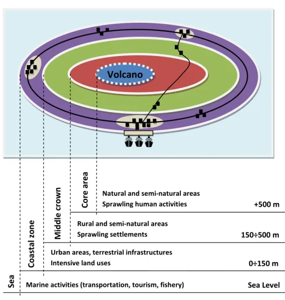
The simplified model of SIs
A simplified model describing the spatial distribution of natural resources, human settlements and activities in volcanic SIs in relation to topography and altimetry was developed. It is based on the fact that most volcanic islands are characterized by an elevation profile and the spatial pattern of the landscape is strongly shaped by its volcanic origin (Pernetta and Manner, 1994; Aretano et al., 2013). In this context, natural factors generate a complex mosaic of ecosystems and shape the distribution of human activities with a recognizable elevation concentric spatial pattern (Figure 3). Generally speaking, settlements and more intensive land uses are mainly concentrated in flat coastal zones (up to 150 m above sea level) and are usually interconnected by a main circular road. Conversely, extensive land uses (e.g. natural and semi-natural areas) tend to increase with distance from the coast and, eventually, with elevation, thereby dominating the landscape of the core area. The middle crown zone can be defined as a transition ring between the coastal zone and the core area where human settlements are generally more sprawling and land uses are predominantly rural.
Figure 3: The simplified model of volcanic SIs.
The conversion of the LUC map into a map of conflicts
The map of conflicts was built starting from three main data sources:
the LUC map of Pico derived from aerial imagery and developed by the University of the Azores within the Smartparks project (Moreira, 2013; Fernandes et al., 2014);
the SMP described in Figure 3 which sorts the island into four rings according to the main landscape features;
the map of PAs distinguishing between protected and non-protected land.
The LUC map was reclassified, by assigning alternative conflict levels to different LUC categories. However, in order to arrive at this outcome, two preliminary steps were required. Firstly, the original LUC classes were reduced from 17 to 12 LUC categories, by aggregating those land covers with similar features or uses. For example, urban areas and roads were aggregated into “artificial surfaces” as well as areas predominantly covered (more than 80%) by Erica azorica or Myrica faia being aggregated into “natural areas with significant presence of endemic species”.
Volcano
Urban areas, terrestrial infrastructures Intensive land uses
Rural and semi-natural areas Sprawling settlements
Sea Level 0÷150 m 150÷500 m
C
o
a
st
a
l
zo
n
e
M
id
d
le
c
ro
w
n
C
o
re
a
re
a
+500 m
S
e
a
Subsequently, a set of spatial conditions were defined based on two criteria: (i) whether the area was located in those rings of the island the conflicts were mostly in place (or were likely to occur) (i.e. core area and coastal zone); and (ii) whether or not the land was under protection (inside or outside of PAs). Operationally, the LUC map was firstly overlaid and masked with both the SMP and the map of PAs and then reclassified. The reclassification followed a land-use cover type approach. This meant that different levels of conflict were assigned to LUC categories under different spatial conditions. This was achieved through GIS by establishing Boolean conditions (i.e. choice between two spatial alternatives – e.g. whether inside or outside the Park) allowing LUC categories to be reclassified (cf. Bragagnolo & Geneletti, 2014).
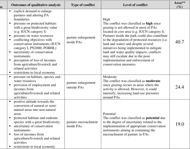
Table 3: Criteria used to map local conflicts.
LUC categories
Spatial
conditions Outcomes of qualitative analysis Type of conflict Level of conflict
Area** (%)
Pastures
Core area -inside the Park
explicit demand to enlarge pastures and altering PA boundaries
pressure on protected habitats with a great biodiversity value (e.g. IUCN category I) pressure on water resources conflicting objectives with conservation instruments (IUCN category I, PN2000, POBHL) uncertainty of conservation instruments
perception of loss of incomes from agriculture/livestock and related activities
restrictions to local economy
pasture enlargement inside PAs
High
The conflict was classified as high since
grazing is not allowed in most of PAs located in core area (e.g. IUCN category I). Pastures inside the park could also contribute to the degradation of protected resources (i.e. land and water) and despite several
initiatives being implemented to mitigate land and water quality impacts, conflicts may still escalate due to the poor implementation and enforcement of conservation measures.
40.7
Core area - outside the Park
pressure on habitats, species and water resources
provision of employment and incomes from
agriculture/livestock and related activities
pasture enlargement outside PAs
Moderate
The conflict was classified as moderate
since grazing occurs in areas where the activity is allowed. However, it could intensify, increasing land-use pressures around PAs.
24.4
Natural areas*
Core area - inside the Park
positive attitude towards the conversion of natural or semi-natural areas into non-semi-natural areas
protected habitats and endemic species with a great biodiversity uncertainty of conservation instruments
loss of incomes from
agriculture/livestock and related activities
restrictions to local economy
pasture encroachment inside PAs
Potential
The conflict was classified as potential due
to the degree of uncertainty related to the implementation of appropriate conservation instruments aiming at containing the encroachment of pasture in PAs.
Core area - outside the Park
positive attitude towards the conversion of natural or semi-natural areas into non-semi-natural areas
landscape connectivity and buffer zones
loss of incomes from
agriculture/livestock and related activities
lack of regulatory and planning instruments
pasture encroachment outside PAs
High
The conflict was classified as high since
outside the park there is a lack of regulatory and planning instruments to control the encroachment of pasture in natural areas. And this could be further exacerbated considering the support of people for the conversion of these areas.
6.0
Bare rocks and soil
Core area - inside the Mountain Reserve
demand for increasing the carrying capacity of the mountain peak for recreation
presence of alpine and sub-alpine habitats
ineffective management of the Mountain Reserve
future development of tourism
Potential
The conflict was classified as potential since
the future consequences of tourism development on mountain ecosystems are uncertain and depend on future decisions (e.g. whether the carrying capacity will be augmented)
9.8
Vineyards (productive)
Coastal zone - inside the UNESCO site
protected and non-protected plants and animals considered pests by farmers
multiple objectives of UNESCO plan
negative perspective associated with building restrictions provision of employment and incomes
restrictions limiting the traditional
viticulture activities in productive vineyards (building,
conservation of protected species, etc.)
Potential
The conflict was classified as potential since
only if the grape production continues to take place can the vineyard cultural landscape be preserved. However, since the main purpose of the UNESCO site is preserving the vineyard cultural landscape, the mitigation/resolution of conflicts greatly depends on future decisions (e.g. incentives and subsidies for wine production, etc.)
12.3
Coastal zone - outside the UNESCO site
protected and non-protected plants and animals in vineyards preservation of cultural landscape provision of employment and incomes
urban pressure
urban encroachment in productive vineyards outside the UNESCO site
High
The conflict was classified as high since outside the UNESCO site the chance of maintaining the vineyards productive is lower due to the greater urban pressure resulting from less strict building restrictions and the absence of clear initiatives
supporting wine production. Thus, these areas can also be more prone to the abandonment.
7.1
vineyards inside the
UNESCO site species multiple objectives of the UNESCO plan
negative perspective associated with building restrictions
the restoration of traditional viticulture activities in
abandoned vineyards (building,
conservation of protected species, etc.)
The conflict was classified as high due to the
explicit conflict between the objectives of conservation instruments (protection of endemic species vs. preservation of cultural landscape).
Coastal zone - outside the UNESCO site
presence of protected endemic species
preservation of cultural landscape urban and tourism pressure
colonization of invasive and endemic species in abandoned vineyards
Potential
The conflict was classified as potential since
the management of invasive and endemic species outside the park mainly depend on future decisions, e.g. prioritizing restoration of cultural landscape, eradicating invasive species, protecting endemic species, etc.
1.7
Semi-natural areas, crops and pastures
Coastal zone - inside the UNESCO site
negative perspective associated with building restrictions presence of both endemic and invasive species
urban and tourism pressure
urban and tourism development inside the UNESCO site
Potential
The conflict was classified as potential
since, although urban and tourism development inside the park is restricted, building regulations could be altered due to future pressures of powerful sectors (e.g. tourism enterprises) and administrations (e.g. local municipalities).
6.4
Coastal zone - outside the UNESCO site
presence of both endemic and invasive species
preservation of cultural landscape urban and tourism pressure
urban and tourism development outside the UNESCO site
Moderate
The conflict was classified as moderate
since, although building restrictions outside the park are less strict, urban development is
already regulated by municipal spatial plans.
54.6
* Natural areas include forests, natural areas with significant presence of endemic species, scrub and/or herbaceous vegetation, peat bogs, bare rocks, bodies of water.
Figure 5: Methodology applied to map conflicts in Pico.
Discussion
This case study demonstrated how a common LUC map can be used to obtain a map of land-use conflicts in PAs. This was done by integrating social data obtained from semi-structured interviews with key stakeholders into a spatially explicit approach, delineating the patterns of landscape features and analyzing land and resource uses that connect conflicting human activities to that particular landscape and land use. The identification and visualization of conflicting zones can support spatial planning policies and conservation initiatives, especially in SI contexts where land-use conflicts can escalate due to resource scarcity.
Methodological limitations and biases
The novel application of the land use cover-type method for mapping land-use conflicts in SIs operationalizes a human ecology mapping approach integrating social data into conservation planning (McLain, et al., 2013). However, there are several limitations in our method.
Apart from the recognized limitations associated with using qualitative methods (Newing, 2011), our stakeholder analysis suffered from:
the limited number of actors. Although our final list included 33 stakeholders, only 19 were available to participate in our interview at the time of the research. Consequently, there may be a bias in our results due to a lack of representativeness of stakeholders, reflecting a lack of perspective from e.g. construction stakeholders; the homogeneity of interests and priorities assumed in selecting stakeholders. Our selection assumed that leaders and heads represented the interests of a group of members (or affiliates – e.g. the association of farmers represents more than 300 members – however, this is not always the case as role-based stakeholder group members have different priorities (Wolfe & Puter, 2002);
the limited exploration of stakeholder inter-relationships. For instance, the analysis showed that reshaping the Park’s boundaries was a need mainly declared by stakeholders representing local authorities and economy. This suggests that a potential alliance against the Park might be established between these two social groups unless the values of the INP are well understood, perceived and shared. One of the methods to better unfold indirect relations would be to build a map of stakeholder interactions (see Rastogi et al., 2010).
Additionally, the main weaknesses related to our method for mapping conflicts rely on:
data availability. As with most spatially explicit approaches, our method depends on the availability of GIS-based data (Van Loenen & Onsrud, 2004);
the consideration of predefined rigid boundaries. By adopting a land-use cover type approach, boundaries of conflicting areas were mostly traced based on landscape and land-use features, disregarding important non-spatial aspects connecting humans to landscapes (social relationships, local identity, etc.) which may influence land-use preferences and values and, thereby, drive land-use conflicts. limited spatial conditions. To simplify the complexity of land-use conflicts, our method only considers island rings and PA boundaries as conditions that determined the spatial distribution of land-use conflicts. In this way, we may disregard other key factors which may conflict with conservation biodiversity on the ground – e.g. land tenure and land-use rights (Phalan et al., 2011). According to Hausner et al (2015), considering land use tenure is essential for understanding conservation and the potential for land use conflict;
subjectivity affecting the definition of the conflict levels. In our work, conflict levels were established through a qualitative analysis which exposes the method to great subjectivity.
Implications of results for local land-use management
Despite the challenge of conciliating nature conservation with landscape protection, preserving traditional landscape is vital for coping with local conflicts within the UNESCO area due to its identity value. This is not to down-play the role of SIs in preserving exceptional biodiversity (Rietbergen et al., 2007). On the contrary, developing tailored mechanisms for in situ biodiversity conservation is considered a key priority for preserving agricultural landscapes.
To resolve conflicts associated with building restrictions, the authors suggest a greater integration between conservation and land-use planning both inside and outside the park’s boundaries. To this end, the Park Authority can play a crucial role, supporting the resolution of conflicts related to the overlapping of planning and management instruments. As elaborated by von Haaren (2002), a more flexible approach to landscape planning needs to be adopted to mitigate conflicts. Future work may include a land-use based analysis to identify, for example, vineyard plots that have been replaced by endemic and protected species. Additionally, vineyard damage should be monitored in order to assess the extent to which protected species are conflicting with the viability of viticulture and vineyard landscape conservation. This could allow restoration and conservation priorities to be defined together with key stakeholders, i.e. the Park, land owners and farmers. Following Lagabrielle et al’s (2011) work, a planning protocol to assess future land-use allocations that combine both biodiversity and socioeconomic criteria is also necessary as part of future work. This would be a valuable approach for prioritising sites for conservation, restoration or transformation of land in an SI context.
Although not raised as a major issue during this analysis, the issues of land tenure and land use rights deserve greater attention within the UNESCO site. It is crucial to find financial mechanisms that could meet the needs of landowners who are not interested in vineyard maintenance and potential landless viticulturists such as young farmers, as well as compensating owners whose land has biodiversity conservation potential, e.g. vineyards colonized by endemic species with a great biodiversity value (Pascual & Perrings, 2007).
In the core area, the results highlighted that the main conflict associated with PAs revolves around the encroachment of pastures into natural areas. Stakeholders representing the local economy and authorities held the Park responsible for the reduction of areas suitable for livestock grazing that consequently constrained local development in farming, livestock keeping and the dairy industry.
Minor conflicts on tourism-related issues also emerged from this analysis such as scarce services and limited access to the mountain, and excessive restrictions on ecotourism development. With the increasingly growing tourism sector, these issues need to be attended to in order to avoid intensification of future impacts and conflicts.
Lessons learnt and challenges on PA conflict mapping for SIs
This research contributes to the transposition of conflicts described by stakeholder discourse into a spatially explicit tool that can help conflict identification and further work on conflict resolution. Through analyzing local conflicts related to PAs on Pico island, we provided a first approach to mitigating conservation-development conflicts in SIs, by showing how limited resources together with restrictions associated with nature conservation may increase the emergence of social tensions and provide a first approach to visualize where stakeholder perceptions are most likely to come into dispute. The work provided some useful insights for advancing PA conflict mapping in SIs.
Firstly, we demonstrated how a common LUC map can be used to generate a map of land-use conflicts in PAs. This is particularly noteworthy for the SI context, considering their limited human and financial resources (Calado et al., 2007), as this approach does not require advanced skills and expertise in comparison to other more sophisticated and expensive approaches used to map and model land-use changes and conflicts (Barnaud et al., 2013). The method may also represent an important communication tool and can be used as a springboard for participatory mapping and scenario exercises, guiding strategic decision-making towards the sustainable future development, an important prerequisite for facing challenging development problems in SIs (Stratigea & Katsoni, 2015). The map of conflicts can also be improved, by combining the method with MCA, including additional spatial criteria (e.g. land use tenure) and performing a more robust ranking of conflict levels using different land-use preferences (or weights) of multiple stakeholders (Iojă et al., 2014). Finally, the map can be
validated with different stakeholders (e.g. citizens) by using interactive tools (e.g. touch screen interface) allowing boundaries to be changed and levels of conflict to be altered. Alternatively, a new land-use conflicts map can be elaborated starting from a topographic map, by organizing participatory workshops with stakeholders and applying drawing interactive tools (Arciniegas & Janssen, 2012). The result can be overlaid and compared with our original map. Secondly, our method showed how the LUC map derived from aerial imagery provided an efficient and low-cost tool to perform a preliminary analysis of biodiversity patterns at an island scale. According to Lagabrielle et al (2011), a basic habitat patterns map is essential for supporting conservation in insular regions by providing a prompt way of representing biodiversity at an island scale before gathering additional costly biological data. However, even when a fine-scale LUC map/landscape map is not available at an island scale, the method could also work using coarse-scale maps with less detail to obtain a more general map of conflicts. Conversely, this method also allows for up-scaling depending on local specificities and capabilities temporally and spatially, e.g. more refined LUC map as it becomes available, inclusion of more details based on on-site reconnaissance.
emblematic SI by observing local stakeholder perspectives towards nature conservation and landscape protection. Considering the unique characteristics of the Pico landscape, its UNESCO status plays a key role in building local identity and cohesion, and correspondingly reducing local conflicts in PAs. Thus, when PAs with conflicting objectives are integrated into the same management system, e.g. different IUCN categories, a more flexible governance framework should be considered for each type of PA such as co-management or government management. In place of risking the implementation failure of the conservation policy, this could be a good starting point for implementing a more adaptive approach to conservation.
Findings from this study underlined several key challenges for dealing with local conflicts in PAs. Of significance, the results demonstrated how conservation policies established at a broader scale may generate or increase social tensions when implemented at a local level, thereby limiting the achievement of global conservation goals. As the case study revealed, despite the new conservation policy having received a broad consensus at regional level (the protection of natural resources is considered a key priority for the sustainable development of the Azores archipelago), its implementation at a local scale encountered conflicting positions gaining unexpected resistance. The need to harmonize conservation policies with multiple scales governance is very important for SIs (Aretano et al., 2013). Consequently, the authors generally recommend PA managers to disseminate and communicate effectively both their rationale and objectives prior to implementing any changes such as reclassification of PAs and restructuring of PA staff or authorities. This is an essential prerequisite for achieving a better alignment between PAs’ goals and people’s values which is a proactive form of minimising social conflicts. One way of fostering a favourable perception towards the Park is: to establish incentive measures for conservation such as encouraging park visitors to pay user fees (Steckenreuter & Wolf, 2013), implementation of socially inclusive programs for residents (Pretty & Smith, 2004) as well as development of tailored educational awareness programmes.
Conclusion
Acknowledgements
We thank all the members of the research team of the Project “SMARTPARKS”, funded by Foundation for Science and Technology (FCT Portugal) [PTDC/AAC-AMB/098786/2008]. We thank Artur Gil for developing and providing the LUC map. Thanks also to the anonymous reviewers for contributing to greatly improve this work.
References
Andrade, G. & Rhodes, J. (2012). Protected areas and local communities: an inevitable partnership toward successful conservation strategies? Ecology and Society 17(4), 1-16. Arciniegas, G. & Janssen, R. (2012). Spatial decision support for collaborative land use
planning workshops. Landscape and Urban Planning 107(3), 332-342.
Aretano, R., Petrosillo, I., Zaccarelli, N., Semeraro, T. & Zurlini, G. (2013) People perception of landscape change effects on ecosystem services in small Mediterranean islands: a combination of subjective and objective assessments. Landscape and Urban Planning, 112, 63-73.
Arnstein, S.R. (1969). A ladder of citizen participation. Journal of the American Institute of Planners 35(4), 216-224.
Bardin, L. (1977). L’Analyse de Contenu. Paris: Presses Universitaires de France.
Barnaud, C., Le Page, C., Dumrongrojwatthana, P. & Trébuil, G. (2013). Spatial representations are not neutral: Lessons from a participatory agent-based modelling process in a land-use conflict. Environmental Modelling & Software 45(1), 150-159. Becu, N., Neef, A., Schreinemachers, P. & Sangkapitux, C. (2008). Participatory computer
simulation to support collective decision-making: Potential and limits of stakeholder involvement. Land Use Policy 25(4), 498-509.
Bentz, J., Dearden, P., & Calado, H. (2013). Strategies for marine wildlife tourism in small islands-the case of the Azores. Journal of Coastal Research SI 65.
Bonaiuto, M., Carrus, G., Martorella, H. & Bonnes, M. (2002). Local identity processes and environmental attitudes in land use changes: The case of natural protected areas. Journal of Economic Psychology 23, 631-653.
Borrini-Feyerabend, G. (1996). Collaborative Management of Protected Areas: Tailoring the Approach to the Context. Gland, Switzerland: IUCN.
Bragagnolo, C. & Geneletti, D. (2014). Dealing with land use decisions in uncertain contexts: a method to support Strategic Environmental Assessment of spatial plans. Journal of Environmental Planning and Management 57(1), 50-77.
Brody, S.D., Highfield, W., Arlikatti, S., Bierling, D.H., Ismailova, R.M., Lee, L. & Butzler, R. (2004). Conflict on the coast: using geographic information systems to map potential environmental disputes in Matagorda Bay, Texas. Environmental Management 34(1), 11-25.
Brown, G. & Raymond, C.M. (2014). Methods for identifying land use conflict potential using participatory mapping. Landscape and Urban Planning 122, 196-208.
Calado, H., Lopes, C., Porteiro, J., Paramio, L. and Monteiro, P. (2009). Legal and technical framework of Azorean protected areas. Journal of Coastal Research SI 56, 1179-1183. Calado, H., Quintela, A. & Porteiro, J. (2007). Integrated Coastal Zone Management
Strategies on SIs. Journal of Coastal Research SI 50, 125-129.
Calado, H., Vergílio, M., Fonseca, C., Gil, A., Moniz, F., Silva, S.F., Moreira, M., Bragagnolo, C., Silva, C. & Pereira, M. (2014). Developing a planning and management system for protected areas on small islands (The Azores archipelago, Portugal): the SMARTPARKS Project. Revista Gestão Costeira Integrada/Journal of Integrated Coastal Zone Management, 14(2), 335-344.
Calado, H., Bragagnolo, C., Silva, S., Vergílio, M. (2016) Adapting Environmental Function Analyses for Management of Protected Areas in Small Islands - Case of Pico Island (the Azores). Journal of Environmental Management 171, 231-242.
Castro, P. & Nielsen, E. (Eds) (2003). Natural resource conflict management case studies: an analysis of power, participation and protected areas. Rome, Italy: FAO.
Corlett, R.T. (2015). The Anthropocene concept in ecology and conservation. Trends in Ecology & Evolution 30(1), 36-41.
Cruz, J.V. (2003). Groundwater and volcanoes: examples from the Azores archipelago. Environmental Geology 44(3), 343-355.
Dapueto, G., Massa, F., Costa, S., Cimoli, L., Olivari, E., Chiantore, M., Federici, B. & Povero, P. (2015). A spatial multi-criteria evaluation for site selection of offshore marine fish farm in the Ligurian Sea, Italy. Ocean & Coastal Management 116, 64-77.
Davies, A.L., Bryce, R. & Redpath, S.M. (2013). Use of multicriteria decision analysis to address conservation conflicts. Conservation Biology 27(5), 936-944.
DeChurch, L. & Marks, M. (2001). Maximizing the benefits of task conflict: The role of conflict management. The International Journal of Conflict Management 12, 4-22. De Pourcq, K., Thomas, E., Arts, B., Vranckx, A., Léon-Sicard, T. & Van Damme, P. (2015).
Conflict in protected areas: who says co-management does not work? PloS One, 10(12), e0144943.
Dias, E. & Melo, C. (2010). Factors influencing the distribution of Azorean mountain vegetation: implications for nature conservation. Biodiversity and conservation 19(12), 3311-3326.
Dias, E., Mendes, C., Melo, C., Pereira, D. & Elias, R. (2005). Azores central islands vegetation and flora field guide. Quercetea, 7, 123-173.
DL n. 78/72. Determina que a Caldeira do Faial passe a constituir uma reserva integral, de acordo com o estabelecido no n.º 4 da base IV da Lei n.º 9/70.
DL n. 316/89. Regulamenta a aplicação da Convenção da Vida Selvagem e dos Habitats Naturais na Europa.
DL n. 19/93. Estabelece as normas relativas à Rede Nacional de Áreas Protegidas.
DL n. 140/99. Revê a transposição para a ordem jurídica interna da Directiva n.º 74/409/CEE e da Directiva 92/43/CEE.
DLR 21/93/A. Aplica a região o regime jurídico estabelecido pelo DL n. 19/93 (Rede Nacional de Áreas Protegidas).
DLR n. 15/2007/A. Decreto Legislativo Regional que procede à revisão da Rede Regional de Áreas Protegidas da Região Autónoma dos Açores e determina a reclassificação das áreas protegidas existentes.
DLR n. 20/2008/A. Decreto Legislativo Regional que cria o Parque Natural da Ilha do Pico. DLR n. 15/2012/A. Decreto Legislativo Regional que estabelece o regime jurídico da
conservação da natureza e da biodiversidade.
Dumrongrojwatthana, P., Le Page, C., Gajaseni, N. & Trébuil, G. (2011). Co-constructing an agent-based model to mediate land use conflict between herders and foresters in northern Thailand. Journal of land use science 6(2-3), 101-120.
Dudley, N. (Ed.) (2008). Guidelines for applying protected area management categories. Gland, Switzerland: IUCN.
Eadens, L.M., Jacobson, S.K., Stein, T.V., Confer, J.J., Gape, L. and Sweeting, M. (2009). Stakeholder mapping for recreation planning of a Bahamian national park. Society and Natural Resources 22, 111-127.
Ervin, J., Sekhran, N., Dinu, A., Gidda, S., Vergeichik, M. & Mee, J. (2010). Protected Areas for the 21st Century: Lessons from UNDP/GEF’s Portfolio. New York: United Nations Development Programme and Montreal QC: Convention on Biological Diversity.
Ferber, J. (1999). Multi-agent systems: An introduction to distributed artificial intelligence. Boston MA: Addison-Wesley Longman.
Fernandes, J.P., Guiomar, N., Freire, M. & Gil, A. (2014). Applying an integrated landscape characterization and evaluation tool to small islands (Pico, Azores, Portugal). Revista Gestão Costeira Integrada/Journal of Integrated Coastal Zone Management, 14(2), 243-266.
Freeman, R.E. (1984). Strategic management: A stakeholder approach. New York: Basic Books.
Gary Polhill, J., Gimona, A. & Aspinall, R.J. (2011). Agent-based modelling of land use effects on ecosystem processes and services. Journal of Land Use Science 6(2-3), 75-81. Geneletti, D. & van Duren, I. (2008). Protected area zoning for conservation and use: A
combination of spatial multicriteria and multiobjective evaluation. Landscape and Urban Planning 85(2), 97-110.
Gifford, R. & Sussman, R. (2012). Environmental attitudes. In S.D. Clayton (Ed.), The Oxford handbook of environmental and conservation psychology, pp. 65-80. Oxford: Oxford University Press.
Gilman, E.L. (1997). Community based and multiple purpose protected areas: A model to select and manage protected areas with lessons from the Pacific Islands. Coastal Management 25(1), 59-91.
Habtemariam, B.T. & Fang, Q. (2016). Zoning for a multiple-use marine protected area using spatial multi-criteria analysis: The case of the Sheik Seid Marine National Park in Eritrea. Marine Policy 63, 135-143.
Harris, T. M. & Weiner, D. (1998). Empowerment, Marginalization and ‘Community-Integrated’ GIS, Cartography and Geographic Information Systems 25(2), 67-76.
Hausner, V.H., Brown, G. & Lægreid, E. (2015). Effects of land tenure and protected areas on ecosystem services and land use preferences in Norway. Land Use Policy 49, 446-461. Indrawan, M., Lowe, C., Sundjaya, Hutabarat, C. & Black, A. (2013). Co-management and the