MARLEI POZZEBON [email protected] Professor at École de Hautes Études Commerciales Montréal, Department of International Business – Montréal – Québec, Canada and Fundação Getulio Vargas, Escola de Administração de Empresas de São Paulo – São Paulo – SP, Brazil
SONIA TELLO ROZAS [email protected] Professor at Université du Québec à Montréal, École des Sciences de la Gestion – Montréal – Québec, Canada
NATALIA AGUILAR DELGADO [email protected] PhD Candidate in Management at McGill University, Faculty of Management – Montréal - Québec, Canada
ARTICLES
Submitted 12.17.2012. Approved 09.25.2013
This article is co-authored by a member of RAE’s Scientiic Editorial Board and was evaluated by double blind review process with impartiality and independence. Scientiic Editor: Charles Kirschbaum
USE AND CONSEQUENCES OF PARTICIPATORY
GIS IN A MEXICAN MUNICIPALITY: APPLYING A
MULTILEVEL FRAMEWORK
Uso e consequências de um SGIS participativo em uma municipalidade do
México: aplicando um modelo multinível
Uso y consecuencias de un SIG participativo en un municipio mexicano:
aplicando un modelo multinivel
ABSTRACT
This paper seeks to understand the use and the consequences of Participatory Geographic Information System (PGIS) in a Mexican local community. A multilevel framework was applied, mainly inluenced by two theoretical lenses – structurationist view and social shaping of technology – structured in three dimensions – context, process and content – according to contextualist logic. The results of our study have brought two main contributions. The irst is the reinement of the theoretical framework in order to better investigate the implementation and use of Information and Communication Technology (ICT) artifacts by local communities for social and environmental purposes.The second contribution is the extension of existing IS (Information Systems) literature on participatory practices through identiication of important conditions for helping the mobilization of ICT as a tool for empowering local communities.
KEYWORDS | Participatory Geographical Information Systems, local communities, structuration theory, social uses of technology, social consequences of technology.
RESUMO
Este artigo busca entender o uso e as consequências do Sistema de Informação Geográfica partici-pativa (SIGP) em uma comunidade local mexicana. Uma estrutura de múltiplos níveis foi aplicada, influenciada principalmente por duas óticas teóricas – a visão estruturacionista e configuração social da tecnologia – estruturada em três dimensões – contexto, processo e conteúdo – de acordo com a lógica contextualista. Os resultados do estudo trouxeram duas contribuições principais. A primeira é o refinamento do quadro teórico a fim de investigar melhor a implantação e uso de Tecnologia de Informação e Comunicação (TIC) por comunidades para fins sociais e ambientais. A segunda contri-buição é a expansão da literatura dos Sistemas de Informação (SI) existentes em relação às práticas participativas através da identificação de condições relevantes que podem auxiliar a mobilização das tecnologias de informação e comunicação como ferramentas de empoderamento de comunidades. PALAVRAS-CHAVE | Sistema de Informação Geográfica Participativa, comunidades locais, teoria estru-turacionista, uso social da tecnologia, consequências sociais da tecnologia.
RESUMEN
Este trabajo tiene como objetivo entender el uso y las consecuencias de un sistema de Información Geográfica Participativa (SIGP) en una comunidad local mexicana. Fue aplicado un marco multinivel, influenciado principalmente por dos enfoques teóricos – el punto de vista estructuracionista y la for-mación social de tecnología – y estructurado en tres dimensiones – contexto, proceso y contenido – de acuerdo con la lógica contextualista. Los resultados de nuestro estudio ofrecieron dos contribuciones fundamentales. La primera es el refinamiento del marco teórico con el objetivo de investigar mejor la implementación y el uso de aparatos de Tecnología de la Información y la Comunicación (TIC) por co-munidades locales para propósitos sociales y ambientales. La segunda contribución es la ampliación de la literatura de Sistemas de Información (SI) existente sobre prácticas participativas a través de la identificación de condiciones importantes para ayudar a la movilización de las TIC como una herra-mienta para el empoderamiento de comunidades locales.
PALABRAS CLAVE | Información Geográfica Participativa, comunidades locales, teoría de la estructura-ción, usos sociales de la tecnología, consecuencias sociales de la tecnología.
INTRODUCTION
Geographical Information System (GIS) has been increasingly applied to diferent areas, such as urban and rural spatial plan-ning and natural resources management. Although GIS can also represent a series of manual cartographic overlays, they are more commonly computer-based (Puri, 2007). During the last few decades, the steadily decreasing cost of computer hardware and the availability of user-friendly software has allowed the dif-fusion of this modern spatial technological artifact to non-gov-ernmental and community-based organizations, groups that had previously been excluded from the spatial decision mak-ing process (Rambaldi, Kwaku Kyem, McCall, & Weiner, 2006). We call the implementation of a GIS “participatory” (PGIS) when a set of inclusive practices are applied to incorporate participa-tion of local people in all phases of the project, from design and information gathering to map production and decision making.
The purpose of this study is to investigate a particular PGIS – the Sierra Nevada Project (SN project) – implemented in a small Mexican municipality called Tlalmanalco. In that region, for the past 30 years, a series of environmental threats, com-bined with unequal economic development, have been under-mining the connection between the local population and their land. In 1997, after a metropolitan planning authority predicted an ecological crisis for the next decade, a university/community initiative called Proyecto Sierra Nevada was established to con-tain urban sprawl and ecological dangers through local and sus-tainable development projects (Moctezuma, 2001). One of the challenges found was the need for re-appropriation of the terri-tory by the community, which was addressed with the help of an innovative implementation of PGIS.
Using this case as background, our article aims to analyze the use of a PGIS by a local community and its consequences from a social and sustainable perspective. The meaning of com-munity would merit a separate discussion in itself, as a huge variety of deinitions can be found in the literature (e.g., geo-graphic communities, communities of culture, communities of interest, international community, etc.). Our deinition of com-munity is in line with Agrawal and Gibson (1999), who shifted the focus from community as a concept associated with small spatial units, homogenous social structures or shared under-standings and identities, to a more complex and multidimen-sional deinition wherein multiple and often divergent groups and interests co-exist, interact, negotiate, and struggle to de-fend diferent preferences for resources use and distribution. The community targeted by this study is located in Tlalmanal-co, a municipality of 45,000 people in Central MexiTlalmanal-co, between the Basin of Mexico and the Sierra Nevada Mountains (Figure 1).
Our study was guided by two research questions: (a) what con-text helps explain the emergence of a PGIS in the Sierra Neva-da region? and (b) what are the main social and environmental consequences of the implemented PGIS to local communities?
Figure 1.
Tlalmanalco community is located in Sierra
Nevada, Mexico
Sierra Nevada Estado de
Mexico
D.F.
Our study brings two main contributions. The irst is the re-inement of a multilevel conceptual framework structured in three dimensions – context, process and content – conceived to inves-tigate the implementation and use of Information and Commu-nication Technology (ICT) artifacts by local communities, from a social and environmental perspective. The second contribution is the extension of existing IS literature on participatory practic-es through identiication of important conditions for helping ICT to work as a tool for empowering local communities, as present-ed in the discussion and conclusion section. Our study is one of the few reporting a successful case, which is in itself a reason why both researchers and practitioners might learn from its results.
BACKGROUND
In this section, we irst present a brief literature review covering PGIS research over the past 15 years; we then present the con-ceptual framework used as a guide in the empirical work.
Overview of GIS and PGIS research streams
compo-nents. The software component brings geographical data into the GIS – either from remote sensing sources, ordinary printed or digital maps, or ield reports – and converts those data into computer-readable form. A second component is the database incorporated by a GIS that allows the data to be managed and de-ployed. The categories of data commonly inserted in such maps are, among others: geographic localization, soil types, vegetation and topographic patterns, fauna, water drainage systems, human occupation and land property, degradation areas.
The results from GIS data analysis are disseminated in a number of ways but most commonly in a map form that sup-ports several layers of information (Wastell, 2006). While many forms of mapping systems have been available since the 1960s,
Madon and Sahay (1997) emphasize that GIS technology has evolved since the early 1980s. Recent developments of this tech-nology, particularly remote sensing-based GIS, have been wide-ly employed to support the sustainable development of natu-ral areas like tropical forests (Hayes & Rajão, 2011).The studies made about GIS and PGIS over the past 15 years were analyzed and organized in three main streams (Exhibit 1).
Exhibit 1.
Three streams of research on GIS
Stream Authors
GIS studies (non-participatory) from the IS literature
Barret et al. (2001); *Hayes and Rajão (2011); Puri (2006); *Rajão and Hayes (2009); Sahay and Robey, 1996; Wastell (2006)
PGIS studies from the IS literature
Aynekulu et al. (2006); Chambers (2006); Nabwire and Nyabenge (2006); Mans (2006); *Puri (2007); *Puri and Sahay (2003); Shrestha (2006); Walsham and Sahay (1999)
PGIS studies from non-IS literature
Aswani and Lauer (2006); Bojorquez-Tapia et al. (2001); *Corbett and Keller (2005); *Dunn (2007); Eisner at al. 2012); *Elwood (2006); *Ghose (2001); *Kyem (2001); *McCall (2003); Peters-Guarin (2012); Sieber (2006)
* Critical views of GIS and PGIS
In the irst and second streams, we have included the vast IS literature in order to better understand the processes of implementing GIS artifacts and the consequences of their use
(e.g., Barrett Sahay, & Walsham, 2001). While the irst stream focuses more on GIS projects taken in a broader sense, the sec-ond particularly targets GIS projects that are participatory in na-ture. In the third stream, we havelooked at studies investigating PGIS through other disciplines, such as urban planning, envi-ronmental management, geography and others. We havefound a huge number of studies and directed our attention to those which ofered a link and potential contribution to IS-related
is-sues, particularly those examining the use of PGIS for spatial planning and natural resources management in order to under-stand how local stakeholders participate in the implementation process as well as the impacts of those participatory projects.
From all these studies, some critical studies have particu-larly drawn our attention. For instance, Kyem (2001) explores how internal (e.g., the complexity and time-consuming characteristics of the process itself) and external (e.g., dependence on external assistance and technology and training costs) factors inluence the degree of local empowerment achieved in PGIS processes. In the same vein, based on the assumption that PGIS can empow-er disadvantaged groups, Corbett and Keller (2005) propose two working deinitions of empowerment – empowerment and em-powerment capacity – and a framework to structure the analysis of empowerment. Other authors emphasize elements inluencing the degree of “inclusiveness” of the process: on the one hand, there are critical divisions within communities related to gender, age, economic class, etc., which lead to an extensive and dii-cult to manage range of needs, opinions and interests (McCall, 2003); on the other hand, there is a portion of the population who do not have appropriate training or capabilities to efectively use the information and, thus, might be excluded from the deci-sion making process (Carver, 2003). Pury and Sahay (2003) and
Puri (2007) examine the use of PGIS to alleviate the problem of land degradation and recognize indigenous (community-related), technical (technology-related) and scientiic knowledge as three important types of knowledge whose mismanagement could lead to important power asymmetries. As we could recognize, knowl-edge and power are two constructs that cannot be easily separat-ed when a critical perspective is adoptseparat-ed.
studies, which will guide our data collection and analysis and thereby help us answering our research questions.
Frameworks for PGIS analysis
We have identiied two distinct frameworks that speciically ad-dress PGIS implementation: Sieber (2006) and Corbett andKeller (2005). Although the two can be seen as complementary, we paid particular attention to the second, due to its underlying critical assumptions. Corbett and Keller (2005) propose a distinction between empowerment (the “output” or increase in power) and empowerment capacity (the “process” of change in internal con-ditions that inluences power). They articulate these two deini-tions within a two-dimensional framework that incorporates two social scales – individual and community – and four catalysts of empowerment, namely: the information contained within a PGIS project (how the documentation, control and use of information contributes to empowerment and changes in empowerment ca-pacity); process (participatory process employed by a PGIS proj-ect, i.e., the mechanisms used to include or exclude parts of a community: invitations, demands, coercion, deliberative eforts, etc.); skills acquired by participation in a PGIS project (ability to use new technologies, e.g., learning to operate equipment, to manage iles, etc.); and tools (speciic equipment) used to devel-op a PGIS. The analysis of empowerment involves, therefore, “ex-ploring how the diferent catalysts cause empowerment as well as changes in empowerment capacity at individual and community levels” (Corbett & Keller, 2005, p. 95).
Although we ind Corbett and Keller’s (2005) model high-ly valuable, it lacks a clearer and more concrete frame to guide empirical work that encompasses multiple levels of analysis. In line with Burton-Jones and Gallivan (2007), we apply the term multilevel to a type of framework that entails more than one lev-el of conceptualization and analysis. The rlev-elevance of studies at thecommunity/societal level is rising, openingopportunities for IS research to address the relationship between ICT and
peo-ple in broader contexts than just organizational settings. Frame-works that incorporate several levels of analysis – individual, group, community, society – are welcome.
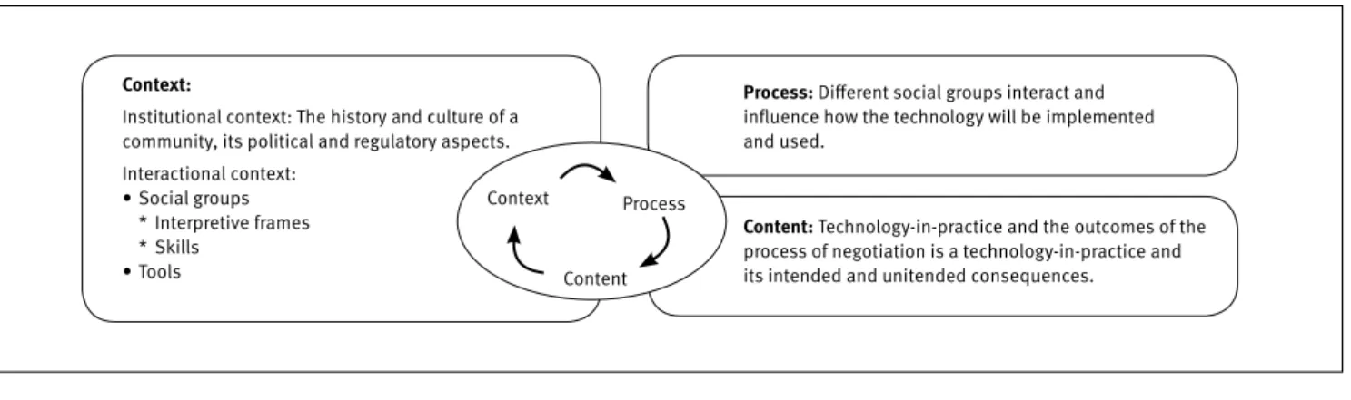
Pozzebon, Diniz, and Jayo (2009) have presented a con-ceptual framework that seems particularly useful for research, involving complex and multilevel interactions between individ-uals, groups, organizations and networks at the community/so-cietal level, struggling to implement and utilize ICT innovations for change and developmental purposes. This framework is in-luenced by three theoretical perspectives: social shaping of technology, structurationist view of technology and contextual-ism.The social shaping of technology pays special attention to the diversity of actors’ interpretations of the meaning and con-tent of technology and emphasizes the identiication of oppor-tunities where decisions and actions regarding technology man-agement and change may be undertaken (Wilson & Howcroft, 2005). Three of the concepts of Pozzebon et al. (2009) theo-retical framework come from this perspective: (1) relevant so-cial groups; (2) interpretive frames; and (3) negotiation. The fourth, (4) technology-in-practice, comes from the second theo-retical inluence, the structurationist view of technology, which represents a well-established IS research stream inluenced by Giddens’ structuration theory (Jones & Karsten, 2008). Fi-nally, the third theoretical inluence comes from the contextu-alist approach, which was irst introduced by Pettigrew (1985, 1990). Arguing that much research on organizational change was non-processual and non-contextual in character, Pettigrew has emphasized three dimensions: context, process and con-tent, and claimed that these three dimensions are equally im-portant and should be considered in concert.
We propose a theoretical scheme to analyze the use and consequences of PGIS in local communities (Figure 2). It com-bines the two frameworks previously described – Pozzebon et al. (2009), further elaborated in Pozzebon and Diniz (2012), and
Corbett and Keller (2005). A detailed deinition of three dimen-sions and their main concepts are provided below.
Figure 2.
Framework for participatory GIS analysis in communities
Context:
Institutional context: The history and culture of a community, its political and regulatory aspects. Interactional context:
• Social groups * Interpretive frames * Skills
• Tools
Process: Diferent social groups interact and inluence how the technology will be implemented and used.
Content: Technology-in-practice and the outcomes of the process of negotiation is a technology-in-practice and its intended and unitended consequences. Context Process
The context refers to the social setting where the technologi-cal artifact is being implemented and used, helping to deine the boundaries of the investigation. It has two levels: institu-tional and interacinstitu-tional. As pointed out by Haynes and Rajão (2011) and Barrett et al. (2001), in order for ICT-related projects to contribute to social and environmental changes, it is import-ant to take into consideration the historical, cultural, political and regulatory aspects, i.e., the institutional context. The sec-ond level, the interactional context, includes identiication of diferent social groups interacting in a given social and cultur-al setting and the identiication of interpretive frames for each social group. Subgroups, alliances or coalitions among social groups form political social spaces that shape the choices aris-ing from implementation and use of any kind of technology (Ra-jão & Heynes, 2009), including a GIS. In addition, people with-in a social group are likely to share a set of assumptions, beliefs and expectations about a given subject of interest (for instance, the expected beneits of the implementation of a new technol-ogy like GIS). This leads to the concept of interpretive frames: mental models that shape people’s interpretations, inluencing their actions and decisions (Giddens, 1984). Although individ-ually held, those frames are articulated with value preferences and sectional interests that are shared across groups (Gallivan, 1995). The extent to which frames from diferent groups are con-gruent or conlicting will determine the likelihood of a success-ful implementation and use of GIS (Lin & Silva, 2005). The in-teractional level also encompasses skills and tools (Corbett & Keller, 2005). Skills would denote social groups abilities in gen-eral terms, both regarding use of the technology as well as the social changes they would like to promote (e.g., the ability of community members to use GIS or the ability to organize them-selves in social movements). Tools ought to be regarded not only as speciic artifacts but also as resources (material and i-nancial) and methodologies implemented.
The second dimension is process. It refers to understand-ing how social groups (and their frames) inluence the negotia-tion process taking place around the implementanegotia-tion and use of a given technological artifact. The implementation of a new technology in a community or region can be seen as an oppor-tunity, or risk, to efect change in information low, resource al-location and attribution of responsibility. For this reason, by im-plementing a GIS, people can reproduce, transform, adapt and even reinvent their community practices.
The implemented GIS is seen as the outcome of social processes of interaction between social groups. This leads to the third dimension, content, which refers to the resulting socio-technical characteristics of the technological artifact be-ing implemented, as used by social groups. We pay particular
attention to the resulting consequences, both intended and un-intended (Haynes & Rajao, 2011), of the technologies-in-prac-tice. The concept of technology-in-practice emphasizes the dif-ferent ways by which a given technology can be implemented and used in diferent contexts by diferent social groups (Orli-kowski, 2000). The focus is on the enactment of technology, where people’s choices in the implementation and use of a given technology produce a certain number of consequences, intended or unintended.
METHODS
For the purpose of this investigation, we applied an in-depth single case study (Stake, 2000), the case selected being the SN project. The rationale supporting this choice is that this case study represents a remarkable experience in terms of GIS appropriation by a local community located in a develop-ing region. Not only is Sierra Nevada an example of successful implementation and use of GIS for social and environmental purposes, but it is notable for having been achieved by com-munitarian organization in an efective bottom-up and partici-patory approach as well.
Data collection
The ield work took place in 2006 in Tlalmanalco (Mexico). However, it is important to note that contact with two of the SN project’s leaders, Pedro and Elena, had begun some years before and continued following our stay in Mexico, in the form of telephone calls and meetings in locations outside Mexico. The case study was based on three main sources of data: inter-views, participant observation and documents. This triangu-lation enabled us to reduce the risks of inaccurate interpreta-tions (Denzin & Lincoln, 2003) or problems with validity of the data (Glesne, 1999).
the group “Los guardianes de los volcanes”, in order to enter data in GIS regarding recent deforestation or polluted margins of rivers.
The second source of data was semi-structured and non-structured interviews. The respondents were selected ac-cording to one of the concepts described in the theoretical framework: social groups. Among the various social groups in-teracting in Tlalmanalco, four took part in the PGIS
implementa-tion and are recognized as particularly relevant: Sierra Nevada Team (SN team), researchers from Autonomy University of Mex-ico (UAM), Sierra Nevada (province) and Tlalmanalco (munici-pality) governmental authorities, and Tlalmanalco community organizations. One of our respondents (Pedro) is part of two so-cial groups: SN team and UAM researchers. Exhibit 2 presents a summary of the interviewees.
Exhibit 2.
Data collection – summary of interviews
Type Respondents Role Social group
Individual interviews (total = 6 semi-structured interviews)
Pedro (2 interviews) Leader of SN team (general project coordinator) and UAM professor and researcher
SN Team UAM researchers
Elena (1) Leader of SN team (project coordinator) SN Team
Gisela (1) GIS designer and operator SN Team
Delia (1) Coordination of community movements; GIS data entry SN Team
Rebeca (1) Community communication and GIS trainning SN Team
Collective interviews (total = 2 non-structured interviews)
8 Students + 1 coordinator (1)
Members of the social group “Los guardianes de los volcanes”
TIalmanalco community organizations
3 Municipal
authorities (1) Members of the group “Los regidores” (the aldermen) Governmental organizations
A total of six individual semi-structured and two collec-tive non-structured interviews were carried out. The semi-struc-tured interviews were conducted twice with the general coordina-tor of the SN team (Pedro), once with the co-coordinacoordina-tor (Elena), and once with other three other members (Gisela, Delia and Re-beca). The two non-structured interviews were carried out collec-tively (with 9 and 3 people participating, respeccollec-tively), involving two other social groups: Los guardianes de los volcanes (a group of students engaged in a community project for environmental monitoring) and the Regidores (aldermen in local government). Although focus groups are also collective interviews, we cannot consider our strategy a focus group because in our collective in-terview we follow the semi-structured inin-terview guideline in a more linear way than what is expected in a focus-group. All these interviews were based on a protocol created from the multilevel framework, were tape-recorded, and were transcribed verbatim.
Finally, and no less importantly, we had access to numer-ous documents, articles, doctoral dissertations and PowerPoint presentations, some provided by the SN team and others found on the Internet and in newspapers.
Data Analysis
The analysis of the empirical data comprised three phases, fol-lowing Miles and Huberman (1994): (a) data condensation, (b) data presentation and elaboration, and (c) veriication of con-clusions. We used NVivo® software to organize the set of data
collected and assigned labels to the units of meaning accord-ing to the codaccord-ing procedure, usaccord-ing the multilevel framework. We also wrote analytic memos to record our ideas, relections, and emerging results. The use of deductive/inductive analysis ena-bled us to reine the framework through an iterative approach, leaving room for emergence of topics or dimensions which had not been initially considered (Patton, 2002; Berg, 2001). The process of categorizing empirical data was built based on the concepts proposed by the framework – social-groups, frames, skills, tools,etc. To the extent that analysis evolved, new labels (categories) emerged, reining the codiication process (an illus-tration of the coding process is available upon request).
RESULTS
In this section we present the data analysis results. In order to answer the two research questions, we have structured this sec-tion according to the three dimensions of our theoretical frame-work: context, process and content.
The context of SN project: institutional and
interactional
the result of a fruitful partnership between the university (UAM) and 12 municipalities, including Tlalmanalco, where the SN team was located. The entire region where Tlalmanalco is locat-ed is considerlocat-ed one of the world’s most densely populatlocat-ed and critically threatened regions, primarily because it is situated directly in the ecological footprint of Mexico City megalopolis. The external threats to the local environment started long ago but had reached a peak by the 1990s. The sense of localness was also disrupted as uncontrolled sprawl from the metropolis threatens to transform Tlalmanalco from a predominantly rural area into a bedroom community (Moctezuma, 2001).
In 1997, soil, water and atmospheric contamination, coupled with urban sprawl in the region, were leading the en-tire region to an ecological crisis. Political authorities seemed powerless to face those challenges. That same year, with UAM professor Pedro as general coordinator, and his wife, Elena, as co-coordinator, SN project was established with the objective of supporting local initiatives by applying academic research and inclusive techniques so as to transform the Sierra Nevada region into a green belt of micro-projects that would contain the en-croaching city and halt environmental destruction of the region. SN team members identiied three dimensions to those region-al chregion-allenges: a) promoting consensus-building around key so-cial and environmental issues; b) mobilizing local communities in a process of collaborative planning, social organization, cap-acity-building and reconnecting the local population with their
natural environment; and c) putting together a multi-stakehold-er process of bottom-up vision-building, collaborative planning and implementation. To deal with these challenges, the SN pro-ject tried to salvage local traditions of community participa-tion and introduce a broader, more participatory process at the regional level involving various local organizations. One of the means to facilitate this process was to provide the community with “geographic literacy”.
We had diferent workshops in which we started working with maps. With this kind of imaginative drawing, how your community draws your munic-ipality, draws up your natural resources manage-ment, does transect to understand the logic in the natural resources management, there emerg-es a regional mirror of which everybody draws a part […]. Our activity was doing these geographic literacy activities. (Pedro)
In addition to the institutional context, the interactional aspect helps elucidate the interactions of social groups. As pre-viously described, we identify four social groups (SN team, UAM researchers, governmental authorities and community organi-zations), each with diferent interpretive frameworks, skills and tools. Exhibit 3 summarizes our analysis of the aforementioned three concepts.
Exhibit 3.
Interactional context of SN PGIS Project
Social Group Interpretative frames Skills Tools (resources and methodologies)
Community organizations
GIS is seen as a tool for improving local development; a tool for provid-ing maps for political and ecological change.
They provide deep local and historical knowledge of their territory.
They do not posses particulat tools.
UAM researchers GIS is seen as a source of knowledge for synthesizing local and technical information.
They provide technical and scientiic knowledge.
They provide technical resources like aerial and satellite photos, oicial maps, etc.
Governmental authorities
GIS is seen as a tool to support politi-cal decisions and policy making.
They provide legal knowledge; they lack skills for an appropriate manage-ment of natural and social resources.
They provide inancial resources and opportunities for contracts.
SN team GIS is a tool for empowering local com-munity members, for leveraging their skills and to guarantee the sustain-ability of the project.
They promote synergies amoung the other groups; they develop skills to operate the technology; they develop skills to estabilish external partner-ships and to reach the market.
They master and reine inclusive-par-ticipatory methodology; they obtain a license to use GIS and other devices like GPS.
tool to address the region’s ecological problems. By participating in the SN project, local community members expect to improve their welfare and promote the sustainable development of their city. For instance, “Los Guardianes de los Volcanes” is a group of about 35 students from diferent municipalities around Tlalma-nalco that actively participate in the SN project by gathering data and monitoring ecological sites. One of the members says:
We want to make this a better region to live in…. our rivers are contaminated (student).
Other community groups look forward to having access to information necessary to improve their knowledge and owner-ship of their land. For example, the “ejidatarios” (traditional-ly responsible for public community lands) and rural producers have participated actively in data gathering for the municipal atlases because they wanted to see the exact boundaries of their lands incorporated into a map. Until the beginning of the SN project, the oicial maps describing the boundaries of the community-owned lands (termed ejidos) were treated as priv-ileged documents in the possession of elected leaders. “Ordi-nary” people in the locality could not gain access to them, and nobody really knew where the communal lands were anymore.
The UAM researchers represent the second relevant social group to the project, mainly because of the legitimacy they bring: working together with SN team and the community, they are es-sential to endowing it with credibility and quality in the eyes of governmental authorities and the media. The partnership with UAM allowed the SN project to obtain signiicant governmental contracts. In turn, university professors gain access to rich local knowledge, which contributes to their academic interests.
To do good research, they [UAM researchers] need local guides, then they can have access to all the information that local people have, which you can’t get from a satellite. (Elena).
Therefore, UAM researchers perceive the GIS as source of knowledge that combines and synthesizes local and technical information. The products of the SN project (e.g., GIS maps and atlas) are used to complement their teaching and research ac-tivities. Correspondingly, UAM researchers provide technical re-sources (e.g., aerial photos) and scientiic knowledge related to topography, ecology, geography, botany, etc.
The assumptions and expectations concerning the SN project held by the third social group, thegovernmental au-thorities, are related to the potential use of PGIS maps as a tool to support their political decisions, with particular regard
to natural resource planning. At the municipal level, the local authorities trust the GIS maps generated by the SN team and believe that this tool will help them resolve impasses over cer-tain territory being claimed by a neighbouring municipality. Through use of GIS maps, they are able to prove that the area belongs to them.
We trust the (GIS); mapping the territory, we will know exactly the territory of our municipality (Regidores, municipal authorities).
Concerning their skills, on the one hand, governmental authorities provide the legal knowledge – about regulations, laws and governmental requirements –required to produce GIS maps. On the other hand, they lack skills for appropriate management of natural and social resources.
We gathered enough data to argue and tell – you know, this land is ours – with a clear support of SN team at a technical level. Without this sup-port, we could not inish our plan. (Regidores, municipal authorities)
The governmental authorities provide the SN project with inancial resources to support certain activities (e.g., research activities) and with access to new important contracts (such contracts for drawing up natural resources plans).
Last but not least, the fourth social group is the SN team, whose members share a common vision of the GIS: because their main goal is to empower the community members, they see GIS as a tool to enhance community competences, to cata-lyze their emancipation and to guarantee the project goals’ sustainability. Thus, the SN team hasdeveloped the ability to create a synergy between the community and the other social groups – mainly UAM researchers and governmental author-ities – who are interested in the GIS for diferent reasons. They have also succeeded in establishing partnerships with external stakeholders in order to reach the market and to strengthen the project. For example, looking for a lexible way to introduce in-formation and produce maps, they initiated contact with an im-portant North American GIS vendor and, in 1999, they have pur-chased their irst copy of the basic software, Arq-View, for a trial run. The process evolved quite rapidly thereafter.
It is important to mention that although the interpretive frames, i.e., the assumptions, beliefs and expectations of the four social groups were neither similar nor convergent, but more importantly, they were not conlicting or divergent, at least not during the implementation of the PGIS. It is quite acceptable that before or even in some moment during the project some small divergences occurred. Because our interviews were retro-spective we could not grasp the evolution of frames over time.
The process of implementing a PGIS
The SN project implementation is characterized by two key phases: (1) data gathering and map production, and (2) knowl-edge sharing and map providing. Figure 3 represents these two phases, the social groups involved and the type of interaction in terms of knowledge and resource sharing.
Figure 3.
Process of SN project
Local authorities
Local
community Communitygroups expertsUAM
Government SN
Team
Local/historical
knowledge Technical knowledge Legal
knowledge
SS
1. Data gathering and maps production 2. Knowledge sharing and map proving
First phase of process: data gathering and map produc-tion- In this irst phase, we outline the presence of three dif-ferent types of knowledge: (a) Local (indigenous) and historical knowledge, provided by community members; (b) Technical and scientiic knowledge, provided by university researchers; (c) Le-gal knowledge, provided by governmental authorities, along with inancial resources. These diferent types of knowledge usually do not come together mainly because the social groups that hold them frequently do not sit down together. In addition, as outlined in the previous section, the interests and expecta-tions of those diferent groups regarding the GIS implementa-tion were not necessarily convergent. So, how to make those distinct groups converge?
Although we could not grasp all the process that lead to a consensus among those diferent groups, we are aware that a number of conlicts, tensions and divergences marked the be-ginning of the project. For instance, the “ejidatarios” were very suspicious at irst, they were afraid that the GIS could afect the
allocation of the communal portions of land. Likewise, the munic-ipal authorities were also suspicious regarding Pedro’s political agenda, in the beginning of the project. Our retrospective data do not allow us to enter in the detailed processes of resistance, but we do know that they existed. However, it seems that the con-sensus-building process put in place by the SN team was able to make those people, with diferent perceptions and expectations, sit together and converge their interests around the GIS.
Second phase of process: knowledge sharing and map providing - In the second phase, knowledge, maps and atlases are made accessible for a number of purposes. For example, the community has access, at no cost, to a publication called Muni-cipal atlases of natural resources encompassing the six munici-palities of the Sierra Nevada region. These atlases contain rich information about opportunities and challenges related to nat-ural resource management and community-owned lands. Sim-ilarly, universities integrate the atlases into their teaching ma-terial and academic programs, and governmental entities use them to support public policies and environmental planning. Therefore, due to their maps and atlases richness, the SN pro-ject became a privileged recipient of new governmental con-tracts, increasing the power to inluence public polices:
Having a GIS technology places us in the market with a high value. And it’s allowed us to carry out a number of important interventions in terms of environmental government policy for our region. (Elena).
Moreover, the SN team has created a local documenta-tion center providing: free maps for local farmers seeking to learn the precise boundaries of their lands or where erosion or deforestation is most serious; information (for a small fee)for tourists wishing to locate a waterfall in relation to the road, or a place to observe a profusion of butterlies, or alternative bike paths around a volcano; and maps for students, teachers, lo-cal producers, associations, cooperatives, community groups, eco-tourists, mountaineers, and municipal, regional and (more recently) national authorities that have joined other academic and political bodies. This strategy – free access to a new type of knowledge that did not exist before and that mesh, blend difer-ent kind of expertise –contributes to the community empower-ment and is one of the SN project main achieveempower-ments.
The consequences of technologies “in practice”
We note that the GIS-in-practice produced a number of intended and unintended consequences (Figure 4). This “practice” view is important because we are not outlining the inal technical fea-tures of the technology put in place but, rather, the social uses of the technology as mobilized by diferent social groups.
Intended consequences - Among the targeted goals of SN project, perhaps the most important one was achieved: commu-nity awareness and empowerment. One of the challenges ini-tially identiied by the SN project was the loss of connection between the local population and their land. Elena, SN project
co-coordinator, remembers the results of a survey carried out at the beginning of the project concerning what local young people felt their future would be like.
A typical response was: ‘My future is in Mexico City. Here is nowhere’. This is part of our chal-lenge… part of the work we are trying to do is to help people re-appropriate their space because, in the urbanization process, people gradual-ly lose the connection with the forests, with the earth around them and their vital space becomes their house, their yard, and the street in front of it and they don’t think about anything else. They don’t feel responsible for more than this [limited space]. (Elena)
Seeking to promote a progressive change in this percep-tion, the SN project is succeeding in making local people remain on their land instead of abandoning the region. The participa-tory process served as a tool to promote local community aware-ness concerning their rights, and people began to realize gains from the use of the maps produced with the SN team. Overall, this process empowered their actions.
They recovered this sense of belonging and em-powerment to control their own communal plans. (Pedro)
It is with this outlook that ejidatarios now use the munic-ipal atlases developed to defend their rights.
With the information contained in these atlases they can now defend their lands (Delia).
Finally, in addition to increasing local community partici-pation in their territory’s policy making, the SN project has helped to improve the quality of life and local development. For instance, some outputs of the SN project are used in the coordination of a number of municipal prevention programs involving solid waste management. In addition, geographical information produced was the main input for the elaboration and publication of docu-ments used to develop new economic activities. This is the case with the “Ruta de los Volcanes Sagrados” document used with a tourism project aimed at promoting enjoyable ecological activi-ties, such as horseback riding or waterfall baths.
Figure 4.
Intended and unintended consequences of
GIS-in-practice
Quality of life and local development improvement
Public polices decision making
inluencing
Community empowerment
New community projects
Intended Unintended
GIS-in-practice ?
Unintended consequences - The SN project is resulting in a number of achievements in line with the SN team initial goals. However, one of the strengths of the technology-in-practice view is that it helps to recognize unintended consequences that any im-plementation of technological artifacts may produce. In the case of our investigation, we outline two unexpected positive conse-quences. A clear illustration of an unintended consequence is the production of spillovers for new communitarian projects. The rev-enue generated by the production of rich GIS maps has turned out to be higher than expected, thereby allowing the SN team to i-nance additional, and sometimes unproitable, SN sub-projects, as well as community projects, such as “Pueblos originales de la región de los volcanes” (native people from the volcanic region), concerned with water improvement in the region:
I am a member of this social organization… and I have seen the impact of the technology outside
the project. It is really motivating to be able to have access to this type of information… We are estab-lishing a council for water management and this in-formation is essential for us in our project. (Delia)
DISCUSSION AND CONCLUSIONS
Here we discuss our results concerning the two research ques-tions guiding our study: what context helps explain the emer-gence of a PGIS in the Sierra Nevada region and what are the main social and environmental consequences of the imple-mented PGIS to local communities?
The problems faced by Tlalmanalco in the Sierra Nevada region are similar to those many other Mexican municipalities are facing: they often sufer from poor administrative infrastruc-ture. This lack of skills and resources hinders the development of a more strategic vision and capacity to deal with social and en-vironmental problems in an integrated manner. In line with Ra-jão and Hayes (2009), we corroborate the assertion that the PGIS process that emerged in Tlalmanalco was shaped by an institu-tional context where all information that could inluence politi-cal decisions afecting lopoliti-cal people lives were concentrated in the hands of regional government. Local people were not empow-ered to dialogue and negotiate their needs and rights with region-al government due to the lack of relevant information and knowl-edge. So, what might be put in place to change such a context? The lack of a strong institutional frame helps explain the possibili-ty of emergence of an ICT-related, bottom-up and participatory in-itiative – a community-university partnership committed to local traditions – as a response to the incapacity of the political realm to face mounting social and environmental problems.
Our results complement Corbett and Keller’s (2005)
framework, by indicating howthe multi-stakeholder approach and the community-centered role of the SN team haveput in place two key processes – geography literacy ateliers and con-sensus-building sessions – that allowed the combination of dis-tinct types of knowledge (legal, technical and local). This in turn afected the empowerment capacity of diferent social groups, and particular of local community and university members, by changing their ability to inluence and negotiate. The SN team’s emphasis on competence building (e.g., the geographical liter-acy program) resulted not only in community empowerment, but also in changes in the community’s capacity for empowerment: community members developed not only tools to help them pro-tect their rights (e.g., GIS maps) but also the capacity to deploy those tools, increasing their ability to engage in dialogue with governmental institutions in terms of managing social and natu-ral resources in the region.
These indings are also in line with IS authors who stress the need to take into account macro, institutional factors, like educational process and administrative infrastructure
(Walsh-am &(Walsh-amp; Sahay, 1999) and micro, situated factors, like existing lo-cal power asymmetries (Puri & Sahay, 2003). In addition, our study has corroborated previous studies showing that combina-tions of diferent types of knowledge are likely to create a new type of hybrid knowledge that brings invaluable results when incorporated into map production (Puri, 2007). More important-ly, in the case of the SN project, the SN team was able to cre-ate spaces and occasions for a high accessibility for everyone to this new kind of knowledge, a source of empowerment to all stakeholders, but particularly to the local community.
Another particularity of our results is the analysis of the outcomes not just in terms of pre-established goals but also with attention to unintended consequences. However, while un-intended consequences are often seen as potentially negative
(Hayes & Rajão, 2011), our case shows that the opposite is also possible. A summary of our contributions is presented in Fig-ure 5: the guiding framework is enriched by the data analysis of the particular case study and provides concrete clues to cre-ate the conditions for efective empowerment of local communi-ty through implementation of a technological artifact like a GIS.
Figure 5.
An actionable framework for participatory GIS
Context:
Institutional context: Community organization to compensate the lack of governmental resources and skills to face serious environmental and social problems.
Interactional context: • Multi-stakeholder
• SN team plays a community-centered role, promoting a synergy among distinct interpretive frames, skills and tools.
Key process put in place:
• Geographic literacy ateliers • Consensus-building sessions • New Knowledge accessibility to all
Content of technologies-in-practice:
To pay attention to and beneit from the cause-efect set of intended and unintended consequences of GIS-in-practice.
Context Process
Content
This study provides a number of contributions for re-search and for practice. The reined conceptual framework might support researchers and practitioners in dealing with projects where local communities try to implement ICT arti-facts for social and environmental purposes. We claim that, in addition to the institutional context, the interactional con-text – the diferent social groups with their interpretive frames, skills and tools – should be identiied and understood. In or-der to make this multi-stakeholor-der arrangement work, the project team has an important role to play in order to create a synergy among diferent types of knowledge and promote a convergence among distinct interests. For that, three key pro-cesses were identiied – geographic literacy ateliers,
consen-sus-building sessions and a knowledge free-access platform – and in this vein we contribute to existing literature. Finally, we direct attention to intended and unintended consequences of technologies-in-practice, changing the focus from the techni-cal features of technologies to their efective use.
out data collection – arrived in Tlalmanalco in a period when vir-tually all stakeholders were proud and satisied with the results of the Sierra Nevada, even those more resistant in the beginning of the process. Overall, the four social groups identiied were proud of the reconnaissance that the local project achieved not only locally but regionally. Therefore, is not surprising that they had a tendency to highlight – in the interviews – harmony and convergence instead of conlicts and divergence (which for sure took place in the past). As mentioned in the results presenta-tion, we do have ield notes indicating that, in the beginning of the project, there were conlicts and resistance. For instance, in the irst years of the project, the governmental authorities did not see with trust the fact that the community and the university were working in creating maps – an activity that until then was in charge of government-related agencies. Likewise, Pedro has told us stories of the beginning of the meetings, where very het-erogeneous people were put together, and the trust could not be built easily or quickly. Yet, the consensus-building process-es put in place seem to have worked very well. The second lim-itation is that our retrospective interviews could not grasp the details and micro-processes that characterized the participatory process over time. Although our two research questions are not related to a ine-grained processual narrative, we wish to further explore the dynamics of the participatory process in the next phases of this research.
Finally, we would like to comment on our research design. From a conventional standpoint, our research could be consid-ered limited in terms of the “generalization” of the results, once they are based on a single case study located in Mexican ter-ritory. However, the assumptions guiding the empirical work are founded on robust theoretical traditions like constructiv-ism, structuration theory and contextualism. We do argue, cau-tiously, for the theoretical “transferability” of our results to oth-er contexts, instead of arguing for its “genoth-eralization”, as we do prefer to use the terms “authenticity” and “plausibility” of our results instead of talking about validity and reliability (Poz-zebon, 2004). Our analysis follows a constructivist logic which ofers a means to advance theoretical and practical arguments without any pretention of making universalizing claims.
REFERENCES
Agrawal, A., & Gibson C. (1999). Enchantment and disenchantment: the role of community in natural resource conservation. World Development, 27(4), 629-649.
Aswani, S., & Lauer, M. (2006). Incorporating ishermen’s local knowledge and behaviour into Geographical Information Systems (GIS) for designing marine protected areas in Oceania. Human Organization, 65(1), 81–102.
Barrett, M., Sahay, S., & Walsham, G.(2001). Information Technology and Social Transformation: GIS for Forestry Management in India. The Information Society, 17(1), 5-20.
Berg, B. L. (2001). Qualitative research methods for the social sciences. Massachusetts: Allyn and Bacon.
Burton-Jones, A., & Gallivan, M. (2007). Toward a deeper understanding of system usage in organizations: a multilevel perspective. MIS
Quarterly, 31(4), 657-679..
Carver, S. (2003). The future of participatory approaches using geographical information: developing a research agenda for the 21st
century. Urban and Regional Information Systems Association, 15, 61 -72. Corbett, J., & Keller, C. (2005). An analytical framework to examine empowerment associated with Participatory Geographic Information Systems (PGIS). Cartographica. 40(4), 91-102.
Denzin, N., & Lincoln, Y. (2003). Strategies of qualitative inquiry. Thousand Oaks, California Sage.
Eisner, W., Jelacic, J., Cuomo, C., Kim, C., Hinkel, K., & Del Alba, D. (2012). Producing an indigenous knowledge Web GIS for Arctic Alaska communities: challenges, successes, and lessons learned. Transactions in GIS, 16(1),17-37.
Gallivan, M. (1995). Contradictions among stakeholder assessments of a radical change initiative: a cognitive frames analysis. In: Orlikowski, W., Walsham, G., Jones, M., & DeGross, J. (Eds) Information Technology and Changes in Organizational Work, London: Chapman and Hall.
Giddens, A. (1984). The constitution of society. Berkeley, CA: University of California Press.
Glesne, C. (1999). Becoming qualitative researchers. New York: Longman.
Hayes, N., & Rajão, R. (2011). Competing institutional logics and sustainable development: the case of geographic information systems in Brazil’s Amazon region. Information Technology for Development.
17(1), 4-23
Jones, M. R., & Karsten, H. (2005). Giddens´s structuration theory and information systems research. MIS Quarterly, 32(1), 127-157.
Kyem, P. (2001). Power, participation, and inlexible institutions: an examination of the challenges to community empowerment in participatory GIS Applications. Cartographica, 38(3/4), 5-17.
Lin, A., & Silva, L. (2005) The social and political construction of technological frames. European Journal of Infornation Systems, 14, 45-59. Madon, S., & Sahay, S. (1997). Managing natural resources using GIS: experiences in India. Information and Management, 32(1),45-53. McCall, M. (2003). Seeking good governance in participatory-GIS: A review of processes and governance dimensions in applying GIS to participatory spatial planning. Habitat International, 27(4), 549-573.
Miles, M., & Huberman, A. (1994). Qualitative data analysis. Thousand Oaks: Sage Publications.
Moctezuma, P. (2001). Community-based organization and participatory planning insouth-east Mexico City. Environment and Urbanization, 13(2),117-133.
Orlikowski, W. J. (2000). Using technology and constituting structures: a practice lens for studying technology in organizations. Organization
Science, 11(4), 404-428.
Peters-Guarin, G., McCall, M. K., & van Westen, C. (2012). Coping strategies and risk manageability: using participatory geographical information systems to represent local knowledge. Disasters, 36 (1),1-27
Pettigrew, A. M. (1985). Contextualist research and the study of organizational change processes. In: Mumford, E., Hirschheim,R., Fitzgerald, G., & Wood-Harper, A. (Eds.), Research methods in information systems (pp.53–72), New York: North Holland.
Pettigrew, A. M. (1990). Longitudinal ield research on change: theory and practice. Organization Science, 1(3), 267-292.
Pozzebon, M. (2004). Conducting and evaluating critical interpretive research: Examining criteria as a key component in building a research tradition. In: Kaplan, B. (Ed.). Information Systems Research: Relevant Theory and Informed Practice. London: Kluwer, 275-292.
Pozzebon, M., Diniz, E., & Jayo, M., (2009). Adapting the structurationist view of technology for studies at the community societal levels. In: Dwivedi, Y. D, Lal, B., Williams, M., Schneberger, S., & Wade, M. (Eds.) Handbook of research on contemporary theoretical models in IS (pp.18- 33). Hershey: Information Science Reference.
Pozzebon, M., & Diniz, E. (2012). Theorizing ICT and society in the Brazilian context: a multilevel, pluralistic and remixable framework.
BAR-Brazilian Administration Review, 9(3), 287-307.
Puri, S. K. (2006). Technological frames of stakeholders shaping the SDI implementation: a case study from India. Information Technology for
Development, 12(4),311-331.
Puri, S. K. (2007). Integrating scientiic with indigenous knowledge: constructing knowledge alliances for land management in India. MIS
Quarterly, 31(2), 355-379.
Puri, S., & Sahay, S. (2003). Participation through communicative action: a case study of GIS for addressing land/water development in India. Information Technology for Development. 10(3), 179–200. Rajão, R., & Hayes, N., (2009). Conceptions of control and IT artefacts: an institutional account of the Amazon rainforest monitoring system.
Journal of Information Technology, 24(4), 320-331.
Rambaldi, G., KwakuKyem, P., McCall, M., & Weiner, D. (2006). Participatory spatial information management and communication in developing countries. The electronic journal of information systems in
developing countries, 25(1), 1-9.
Sahay, S., & Robey, D. (1996). Organisational context, social interpretation and the implementation and consequences of geographic information systems. Accounting, Management and Information
Technology, 6(4), 255–282.
Sieber, R. (2006). Public Participation Geographic Information Systems: a Literature Review and Framework. Annals of the Association of
American Geographers, 96(3),491-507.
Stake, R. E. (2000). Case Studies In: Denzin N. and Lincoln, Y. (Ed.). Handbook of qualitative research (pp.435-455). Sage Publications: California.
Walsham, G., & Sahay, S. (1999). GIS for district-level administration in India: problems and opportunities. MIS Quarterly, 23(1), 39-66. Wastell, D. (2006). Information systems and evidence-based policy in multi-agency networks: the micro-politics of situated innovation.
Journal of Strategic Information Systems, 15(3),197-217.
Wilson, M., & Howcroft, D. (2005). Power, politics and persuation in IS evaluation: a focus on ‘relevant social groups’. Journal of Strategic