Effects of deforestation pattern and private nature reserves on the forest
conservation in settlement areas of the Brazilian Amazon
http://www.biotaneotropica.org.br/v1n12/pt/abstract?article+BN00101122001
Jean Paul Metzger
Received: August 01, 2001 Accepted: September 05, 2001Department of Ecology Institute of Bioscience University of São Paulo Rua do Matão, 321, travessa 14, 05508-900, São Paulo, SP, Brazil
Phone: + 55 11 38187564 Fax: + 55 11 38134151 E-Mail: [email protected]
Departamento de Ecologia Instituto de Biociências Universidade de São Paulo Rua do Matão, 321, travessa 14, 05508-900, São Paulo, SP, Brazil
Fone: + 55 11 38187564 Fax: + 55 11 38134151 E-Mail: [email protected]
Abstract
Resumo
The effects of deforestation patterns, private nature-reserve extents and agricultural fallow periods on forest conservation were simulated for settlement projects in the Brazilian Amazon that produce a fish-bone pattern of occupation and where slash-and-burn agriculture is predominantly used. Data for simulation was obtained from previous work at the Bragantina region, the oldest agricultural frontier in the Brazilian Amazon. Forest conservation was evaluated using the size of remnant forest fragments, the amount of interior habitat, the connectivity among fragments and the extent of fragmentation. Results showed that the best scenario for forest conservation is the maintenance of 80% of the lot as private-reserve using deforestation pattern that allow to group the private-reserves from different farmers at the end of the lot. When private-reserve coverage is bellow 80% of the landscape, forest conservation status will be influenced by the deforestation pattern. Some patterns (e.g. random location of deforestation plots) will then be particularly deleterious, producing a highly fragmented landscape, while other patterns (e.g., progressive deforestation from one edge) can allow the maintenance of large forest fragments. To get forest conservation in these cases, private-reserve extent and deforestation pattern should be considered together. Considering both forest conservation and agricultural use, progressive patterns of deforestation (or land use) in a lot of 2,000m by 500m, with private nature-reserves covering 50% of the landscape seems to be the best compromise. To guarantee the private forest preservation, these forests should be pre-established when settlements are planned and grouped at the end of the lots.
Os efeitos de padrões de desmatamento, de extensão das “Reservas Legais” e do tempo de pousio agrícola na conservação florestal foram simulados para assentamentos agrícolas da Amazônia brasileira que produzem padrões de ocupação em espinha-de-peixe” e onde a prática agrícola predominante é de corte-e-queima. As simulações basearam-se na dinâmica da paisagem da região da Bragantina, a mais antiga fronteira agrícola da Amazônia brasileira. O estado de conservação florestal foi inferido utilizando-se o tamanho dos remanescentes florestais, a extensão de floresta de interior, a conectividade e o grau de fragmentação florestal. Os resultados mostram que o melhor cenário para conservação é a manutenção de 80% das propriedades como Reserva Legal (RL) e a utilização de um padrão de desmatamento que permite o agrupamento dos remanescentes florestais dos diferentes proprietários numa única reserva, no fundo dos lotes. Quando RL< 80%, o estado de conservação florestal varia muito em função do padrão de desmatamento. Alguns padrões (e.g., aleatórios) são nesse caso particularmente deletérios, resultando em paisagens altamente fragmentadas, enquanto outros padrões (e.g., desmatamento progressivo a partir das bordas florestais) são capazes de manter grandes fragmentos. Para conservar a floresta quando RL< 80%, o padrão de desmatamento e a extensão das RL têm que ser consideradas conjuntamente. Padrões de desmatamento progressivos em lotes de 2000m por 500m, com RL de 50%, parecem resultar no melhor balanço entre conservação florestal e uso agrícola. Para garantir a conservação, o agrupamento das RL no fundo dos lotes deve ser definido no momento do planejamento dos assentamentos.
Key-words: Deforestation pattern, private nature reserve, forest conservation, landscape planning, Amazonian tropical forest
Introduction
Deforestation of tropical forests is at the origin of several environmental impacts. In particular, it has been considered as a main source of greenhouse gases (Laurance et al. 1998a, Fearnside 2000) and as the main cause of species extinction and biodiversity threats (Laurance et al. 1998b, Laurance & Bierregaard 1997). Despite the risk involved, the Brazilian Amazon is being deforested at an average rate of 1.89 million hectares/year since 1995 (according to INPE 1999), mainly along the main roads and at its southern and eastern borders (Skole and Tucker 1993, Laurance 2000). Almost 15% of the 4 million square kilometers of these forests have already been cut (551782 ha in 1998, INPE 1999). Laurance et al. (2001) estimated that in the optimistic scenario for the Brazilian Amazon development pristine forests will comprise just 27.6% of the region in 2020, and in the non-optimistic scenario only 4.7% of pristine forest will be left.
Today, considering the Amazonian nature-reserves that do not allow human activities (areas with nominally high protection), only 3.78% of the original vegetation is
2 2
legally protected (151,503 km within 4 million km , Dias 1998), and even these areas are in danger due to the facility of access and the weakness of the monitoring system (Peres and Terborgh 1995). It is clear that the definition of new biological reserves based on centers of diversity and endemism is an important task for the Amazonian forest conservation, but it is not enough. New strategies of conservation must be implemented or the Amazon will be reduced to islands of forest surrounded by pastures and other agricultural areas.
Conservation should also occur inside private land. Private forest-reserves and permeable agroforestry systems may be the key components of the landscape to maintain the connectivity among large public natural reserves, if they act as biological corridors, stepping stones or even as permeable matrix for some forest species (Fahrig & Merriam 1985, Taylor et al. 1993, Metzger & Décamps 1997, Lindenmayer et al. 2000, Metzger 2000). The “Legal Reserves” (LR) determined by the Brazilian Forest Code in 1965 may be considered as a useful tool in this direction. According to the Brazilian Forest Code established in 1965, the “Legal Reserve” corresponds to a percentage of each rural property where cutting is not permitted. In the original forested areas of the Brazilian Amazon, 80% of the lot should be maintained as LR. However, LR definition and enforcement has been provoking heated discussion in the Brazilian Congress. On one side, agricultural groups want to preserve their right to use their land and they defend the reduction of Legal Reserve to 50 or 20%. On the other side, conservationist groups fight for the maintenance of the actual Legal Reserve of 80%, arguing that the main vocation of the Amazon is the sustainable exploitation of forest resources (Fearnside 1999). The result of this
debate may have strong influences on the conservation of the Amazon, but data needed for the correct decision is still lacking. In particular, the effect of Legal Reserve definition on the spatial distribution of remnant forest fragments or on the agricultural productivity is not known. The present work aims to contribute in providing this information. I propose to simulate and to test the effect of Legal Reserve extent on forest conservation within settlement projects that produce a fish-bone pattern of deforestation.
Fish-bone pattern can be consider as one of the main pattern of land use occupation in the Brazilian Amazon (Figure 1). This pattern corresponds to settlement projects established by the Brazilian governmental agency of colonization (INCRA). In these settlements, lots for small landholders are disposed systematically along road networks at 2-5 km spacings without considering any abiotic parameter (e.g., slopes, soil conditions, river network). Lot sizes range from 25 ha to 100 ha (INCRA 1996) and are usually rectangular (for example, 2,000m by 500m). The deforestation rate is usually fast in these settlements. In the first years of colonization, annual deforestation varies between 2 and 3 hectares per family and per lot (Fujisaka et al. 1996, Scatena et al. 1996), resulting in more than 70% of deforestation of the lot in the first 20 years, even if the National Forest Code obliges to maintain 80% of the lot with its original vegetation. Due to its simplicity and repetitiveness, fish-bone pattern is an interesting situation for helping one to understand the process of deforestation in Brazil. Several studies were carried out in these regions, in the federal states of Rondônia (Southworth et al. 1991, Dale et al. 1993a, Frohn et al. 1996, Fujisaka et al. 1996, Alves et al. 1999), Acre (Fujisaka et al. 1996), Pará (Scatena et al. 1996, McCracken et al. 1999, Brondizio et al. in press, Moran et al. in press), and Mato Grosso (Oliveira-Filho 2001), aiming to understand the driving forces and proximate causes of land use and land cover changes. At the property scale, models of land use and land cover dynamic try to integrate ecological and socio-economical factors to simulate possible consequences of different landscape management (Dale et al. 1993a, 1993b, 1994).
In fish-bone pattern, farmers usually tend to use the lot from the road (front side) to the back side. However, several alternative patterns of deforestation exist and may occur. As a consequence, the rate of deforestation may vary and the fragmentation pattern resulting from the deforestation can be drastically different. Because ecological processes depend on spatial distribution of forest remnants, the pattern of deforestation has an important role in the functioning of the new landscapes dominated by humans (Franklin and Forman 1987, Forman 1995, Metzger 2000). In the present study, I proposed to study the consequences of different deforestation patterns on forest conservation using sequences of land use pattern that may be considered as simplifications of real patterns of landscape change. In particular, I proposed to analyze the deforestation pattern considering that farmers will predominantly use slash-and-burn agriculture, even if the small land-holder in settlement projects may present several types of land use (e.g., annual crops, fruit tree production, agroforestry and cattle grazing) along the colonization process (McCracken et al. 1999, Moran et al. in press). Slash-and-burn agriculture is an agricultural system well-adapted to tropical climate and soils and accessible to small farmers due to its low-cost (Fearnside 1986). It is a widespread practice used by more than 250 million people on approximately 30% of cultivated land in the world (Attiwill 1994) and is considered as an important proximate cause of tropical land use and land cover changes, and particularly of tropical deforestation. In the
Methods
Simulations
Several ecological, economic and social factors may affect the dynamic of deforestation in slash-and-burn areas, as soil fertility, river drainage, weed pressure, property size, the amount of household labor, age and gender composition of household, distance to market and transportation availability (Homma et al. 1993, Scatena et al. 1996, McCracken et al. 1999). However, a first survey with 134 farmers, responsible for 205 lots of 25 ha (250 by 1000m), showed that these factors were not the driving forces at the household level of land use pattern in slash-and-burn areas from the Bragantina region (Northeastern Brazilian Amazon). When choosing a new agricultural plot, the main factors considered by the farmers seem to be wind direction, house proximity and secondary vegetation age. Usually, they use the lot progressively against the wind (to prevent fire in the forest), cutting and burning the oldest secondary vegetation to install the new agricultural plot, but they also prefer to use areas near the house. Consequently, areas near the house are used more frequently and present shorter cycles in relation to more distant areas. In several places, wind direction is not considered and the lot is used from the front side (near the road) to the back, resulting in a classical fish-bone pattern (Figure 1).
In the present work, I simulated 4 different sequences (patterns) of deforestation (or land use change), 2 fallow period lengths and 3 different Legal Reserve extents. Landscape structure and dynamic data used for simulations were based on previous results obtained in the Bragantina region from 1985 to 1996 (Metzger in press
and submitted).
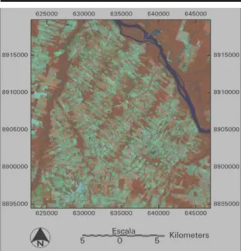
The Bragantina region is one of the oldest agricultural Figure 1. Example of fish-bone pattern of deforestation in the Brazilian
Amazon (Alta Floresta region, MT). The image is a color composition 453 from a Landsat-TM (227/67) acquired on 28 June1998. Dark red areas represent mature forests; light red is secondary vegetation or agriculture; green, light blue to white correspond to pastures or bare soils (prepared for agriculture); and dark blue or black areas are water (rivers or reservoirs).
Brazilian Amazon, 500,000 small farmers use slash-and-burn techniques on at least part of their land (Serrão et al 1996).
In slash-and-burn areas, the deforestation rate and the resulting pattern of fragmentation will depend particularly on fallow period. The proposed agricultural sequences of land use and land cover change will be based on the study of the fallow period length and landscape dynamic from 1985 to 1996 observed in the Bragantina region, the oldest agricultural frontiers in the Brazilian Amazon (Metzger in press and submitted).
Hence, the main objective of this study was to simulate and test the effect of private forest-reserve extent, deforestation pattern and fallow period length on forest conservation in settlement areas where slash-and-burn agriculture is predominantly used. I also tested the effect of different agricultural sequences on the spatial configuration of secondary vegetation and the effect of a slash-and-burn management on forest conservation and secondary forest arrangement.
3
areas in the Brazilian Amazon. Its colonization began in the second half of the 19th century aiming to supply Belém, the Pará state capital (Northeast of the Amazon), with food (Penteado 1967). The fast expansion of the rubber extraction from 1875 to 1902 induced several settlement projects and transformed Bragantina in the region with the highest population density in the Amazon. Later, with the rubber crash, settlement in the region was spontaneous and mainly composed of inhabitants from the Brazilian Northeast leaving their region to escape severe drought (Valverde & Dias 1967). These settlements resulted in drastic changes in land use and land cover pattern. Nowadays, secondary forests cover 50 to 75% of the land, while primary forests have been reduced to less than 20 % and agriculture occupies only 10
to 30% (Metzger in press and submitted).
Simulated landscapes were composed of 20 adjacent lots of 250 by 1000m, the typical lot size in the Bragantina region, totaling 2500 by 2000m or 500 ha. Abiotic factors, such as soil fertility, were considered homogeneous in all studied area, and I did not consider the presence of rivers or other drainage. These factors may have large influence on the landscape structure, however they were not considered for the purposes of the present study in order to enhance the effects of deforestation pattern and private nature-reserve extent. Simulations were performed on raster images with a grain size of 5 meters. Landscapes were totally forested at the beginning of the simulation and were progressively deforested according the agricultural cycles.
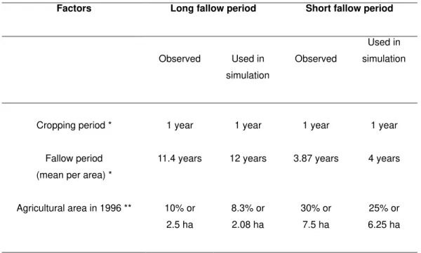
Table 1. Main spatial and temporal parameters of agricultural areas from Bragantina region with short and long fallow period (according to Metzger
in press and submitted)
* Metzger in press ** Metzger submitted
In Bragantina, the crop period lasts only one year, due to intense soil degradation, and fallow periods presented, from 1985 to 1996, an average value of 11.4 and 3.8 years in long and short fallow period areas, respectively, with a tendency of decline (Table 1). I simulated agricultural cycles of 12 and 4 years, with 11 and 3 years of fallow. In this simplified model, the agricultural areas were always grouped together in one area, while the observed pattern is a fragmentation of agricultural plots in 4-6 patches.
Hence, to simulate these two fallow period lengths, each lot was sub-divided in 4 or 12 parts, and each year a new area of 6.25 ha (short fallow period areas) or 2.08 ha (long fallow period areas) was made available for agricultural purposes. Landscape changes in simulation sequences occurred annually up to the total deforestation, when simulating forest conservation status, or up to the end of one agricultural cycle, when simulating the spatial distribution of secondary vegetation.
Factors Long fallow period Short fallow period
Observed Used in
simulation
Observed
Used in
simulation
Cropping period * 1 year 1 year 1 year 1 year
Fallow period
(mean per area) *
11.4 years 12 years 3.87 years 4 years
Agricultural area in 1996 ** 10% or
2.5 ha
8.3% or
2.08 ha
30% or
7.5 ha
25% or
The proposed sequences should be considered as simplified models of real landscape dynamics. Real landscapes are much more complex, changing according to several ecological and socio-economical factors (Homma et al. 1993, Li et al. 1993, Scatena et al. 1996, McCracken et al. 1999, Metzger in press and submitted, Brondízio et al in press, Moran et al. in press). Simplified models allow to isolate the effect of each treatment (deforestation pattern,
1 2 3 4
5
6 7
8
9
10
11
12 1
3 5 7 9 11 12
10
8
6
4
2 8
2 4 1 6 9 12
7
11
3
5
10 1
3 5 7 9 11 12
10
8
6
4
2
SHORT FALLOW PERIOD AREAS
LONG FALLOW PERIOD AREAS ROW
HALF-EDGE RANDOM
EDGE
3 4
2
1
1 2 3 4
1 3 2 4
3 2 1 4
Road
1
0
0
0
m
Back 250m
ROW
HALF-EDGE RANDOM
EDGE
Figure 2. Patterns of deforestation (or agricultural uses) for long and short fallow period areas. The numbers indicate the sequence of deforestation (in the first years) or agricultural uses. Colors represent different land uses or land covers (agricultural areas, young and old secondary vegetation).
Four sequences of agricultural uses (or deforestation patterns in the first years of colonization) were considered (Figure 2): EDGE, where agriculture uses all the lot width, from the front (near the road) to the back of the lot; HALF-EDGE, where agriculture uses the lot progressively from the front to the back, but using half of the lot width in each step; ROW, where agricultural use is done in the first half of the lot width from the front to the back, and in the second half of the lot from the back to the front; and RANDOM, where the sequence of deforestation is done randomly and, when no forest is left, agriculture always uses the oldest secondary vegetation. These 4 sequences can be observed in the Bragantina region, but they are not used systematically and so the present landscape pattern (Metzger in press and
submitted) is more complex and fragmented than patterns created by simulation. The intention here is not to account for all the complexity of deforestation dynamics in real landscapes, but only to present simplified sequences that can help to understand their effects on landscape pattern. Nowadays, the Brazilian Forest Code establishes that in the original forested areas of the Brazilian Amazon, 80% of the lot should be maintained as LR. Recent modifications of the law proposed a reduction of LR to 50%, or even to 20%, as in the case of the most fertile soils from the south of the country. In this study, I will test the effect of these three LR
conditions (80, 50 and 20%) on forest conservation.
Agricultural management effects on forest conservation and secondary forest spatial distribution were evaluated considering the modifications of agricultural cycles proposed by SHIFT, a German-Brazilian program in applied ecosystem research entitled: “Studies on Human Impact on Forests and Floodplains in the Tropics”. This program consider that it is possible to reduce the fallow period to two years and to increase the crop period to two years, reducing nutrient and organic matter losses by the substitution of slash-and-burn with cut, chop and mulch (Kato et al. 1999), and increasing biomass accumulation during fallow periods by introducing fast growing leguminous tree species (Vielhauer et al. 1998). In the managed sequence, the lot is divided in two, half being used for crop and the other part resting as fallow (Figure 3). This scenario allows us to use a larger area of the lot in relation to a classical short fallow period cycle (Figure 3) and is supposed to maintain the soil fertility (Vielhauer et al. 1998).
Figure 3. Edge and managed agricultural sequences
5
Year 3
Year 2 Year 4
Year 1 Year 6
Year 3
Year 2 Year 4
Year 1 Year 6
Managed agricultural sequence
EDGE agricultural sequence with short fallow period
One year old secondary vegetation Two years old secondary vegetation Three years old secondary vegetation Agricultural areas
fallow period, LR definition, lot length) and so are useful tools for the understanding of the effects of these parameters on real landscape patterns and processes (here, on forest conservation and regeneration).
Forest conservation indices
Six indices were chosen in order to quantify and evaluate the effect of each scenario (i.e., agricultural sequence) on the degree of forest conservation (Table 2). These indices were calculated using the software FRAGSTATS 2.0 (a program to calculate landscape fragmentation indices,
McGarigal & Marks 1995), except for the structural connectivity index (the “interior habitat percolation”, IHP) based on Metzger and Décamps (1997). I used a four connector rule for patch (i.e., fragment) definition, grouping similar adjacent pixels considering only the 4 orthogonal neighbor pixels, and edge area width was defined as being 30m, where edge effects are usually more intensively noted (Murcia 1995, Laurance et al. 1997). This width value was considered only for comparative purposes and not to quantify the area of landscape under edge effects.
INDEX UNIT Description
Forest Percentage PF Percent Percentage of the landscape covered by forested areas (0 ? PF ? 100 %).
Largest Patch Index LPI Percent Percentage of the landscape comprised by the largest patch of forest (0 ? LPI ? 100 %).
Mean Patch Size MPI ha Sum of the areas of all forest patches divided by the total number of the patches (MPI ? 0).
Interior Habitat Percolation
IHP Unitless Number of dilations (basic mathematical morphology
transformations, Serra 1982) necessary to obtain a percolation condition of interior forest habitat (Metzger and Décamps 1997). The greater this number, the less connected is the habitat (IHP ? 0).
Number of Patches NP Unitless Number of forest patches (NP ? 1).
Edge Density ED m/ha Sum of the length of all edges segments involving forest unit, divided by the total landscape area (ED ? 0).
Core Area Percentage of Landscape
CORE Percent Percentage of the landscape comprised of forest core areas (0 ? C%LAND ? 100 %).
Table 2. Indices used to quantify spatial configuration of forest areas defined according to McGarigal & Marks (1995).
The best scenarios regarding forest conservation are those that maintain large fragments of forest (LPI, MPS), high connectivity among these fragments (IHP), low fragmentation degree (NP), few edge areas between forest and non-forest units (ED), and high amount of interior habitat (CORE) for a long time. These assumptions are based on several studies that showed that high levels of fragmentation and such small fragments lead to the reduction of population size and increase the risk of species extinction (Forman et al. 1976, Seagle 1986, Rolstad 1991, Saunders et al. 1991, Bellamy et al. 1996, for example). Other studies have showed the importance of connectivity in processes of recolonization after local extinction and in the maintenance of a metapopulation in fragmented landscapes (Verboom et al. 1991, Villard et al. 1992, Sutcliffe & Thomas1996).
Secondary vegetation arrangement
In order to evaluate the spatial distribution of secondary
increase the probability of seed in reaching a regeneration area.
To consider both landscape unit arrangement and configuration, an analysis of the different boundary types was performed according to the methodology presented in Metzger and Muller (1996). The codes of the different boundary types were obtained by the addition of the codes
0 20 40 60 80 100 0 20 40 60 80 100 L arg est P at c h I n d ex ( %) Forest (%) M e an P a tch S iz e ( m/ h a) Forest (%) In teri o r Ha b it a t P erco lat io n N u mb er o f P at ch es Co re A rea ( %) E d g e Den si ty ( m /h a )
Forest (%) Forest (%)
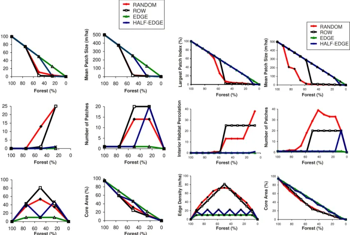
Forest (%) Forest (%) 0 20 40 60 80 100 0 20 40 60 80 100 0 100 200 300 400 500 0 20 40 60 80 100 0 5 10 15 20 25 0 20 40 60 80 100 0 5 10 15 20 0 20 40 60 80 100 0 20 40 60 80 100 0 20 40 60 80 100 RANDOM ROW EDGE HALF-EDGE
Figure 4. Changes in the landscape structure for short fallow period areas according to the deforestation pattern.
of each unit in contact. For example: the contact between forest and agricultural areas will be coded as 17; contact between one and three years old vegetation will result in code 10; etc. The intensity of contacts is then the sum of the codes of the different boundary types. The greater this number in a landscape, the greater the intensity of contacts among land use units and the possibility of regeneration due to the dispersion process.
0 20 40 60 80 100 0 20 40 60 80 100 L a rg es t P at c h I n d e x (% ) Forest (%) M ea n P at ch S iz e (m /h a ) Forest (%) In ter io r Ha b it a t P e rco la ti o n Nu m b er o f P at ch e s Co re Are a (% ) E d g e De n s it y (m /h a)
Forest (%) Forest (%)
Forest (%) Forest (%)
0 20 40 60 80 100 0 20 40 60 80 100 RANDOM ROW EDGE HALF-EDGE 0 100 200 300 400 500 0 20 40 60 80 100 0 10 20 30 40 0 20 40 60 80 100 0 10 20 30 40 0 20 40 60 80 100 0 20 40 60 80 100 0 20 40 60 80 100
Figure 5. Changes in the landscape structure for long fallow period areas according to the deforestation pattern.
The HALF-EDGE pattern showed similar behavior. However, at the end of the deforestation process, the size of forest fragments declined faster and a greater number of fragments is formed. HALF-EDGE pattern had oscillations in the density of edge, particularly conspicuous in the short fallow period areas (Figure 4). The worst deforestation patterns for forest conservation were ROW and RANDOM patterns, in short and long fallow period areas respectively (Figures 4 and 5). In these cases, the negative consequences of forest fragmentation can be observed sooner, with a particularly rapid decline in forest fragments size from only 70% of forest covers, and with the rupture in connectivity and abrupt increase in fragmentation when forest covers 80 to 50% of the landscape.
Effect of fallow period on forest conservation
The comparison between short and long fallow period was performed considering only two contrasting patterns:
RANDOM and EDGE (Figure 6). For EDGE pattern,
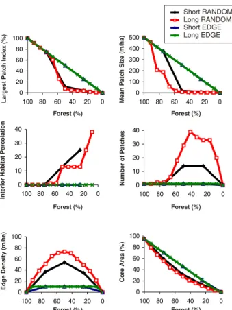
there was no difference in short and long fallow period areas. However, in the case of RANDOM pattern, long fallow period areas clearly resulted in a severe process of fragmentation in relation to the short fallow period that can be noted by the high number of patches and edge density when forest covers near 50% of the landscape, and also by the fast decrease in mean patch size at the beginning of the deforestation process.
7
reduction in the mean patch size (approximately 9 to 4ha for RANDOM; 12 to 6ha for ROW) and in forest core areas (approximately 27 to 11% for RANDOM; 24 to 11% for ROW). In the case of EDGE and HALF-EDGE patterns, deforestation keeps on losing forest without fragmentation. For both patterns, patch size varied from 250 to 100ha, and forest core areas varied from 46% to 17% of the landscape. Without fragmentation effects, EDGE and HALF-EDGE patterns tend to conserve a forest corridor at the end of properties (Figure 1), thus maintaining a high degree of connectivity. This forest corridor width will basically depend on the LR definition and on the lot length: longer lots and higher LR allowed maintaining larger forest corridor width (Figure 7).
L a rg e s t Pa tc h I n d e x (% ) Forest (%) Me a n Pa tc h Si ze (m /h a ) Forest (%) In te ri o r H a b ita t Pe rc o la ti o n N u m b e r o f Pa tc h e s C o re A re a (% ) E d g e D e ns it y ( m /ha )
Forest (%) Forest (%)
Forest (%) Forest (%)
Short RANDOM Long RANDOM Short EDGE Long EDGE 0 20 40 60 80 100 0 20 40 60 80 100 0 100 200 300 400 500 0 20 40 60 80 100 0 10 20 30 40 0 20 40 60 80 100 0 20 40 60 80 100 0 20 40 60 80 100 0 20 40 60 80 100 0 20 40 60 80 100 0 10 20 30 40 0 20 40 60 80 100
Effect of Legal Reserve extent on forest conservation
This effect will be presented only for long fallow period areas (Figure 5) due to the small differences between short and long fallow period areas observed previously.
For all deforestation patterns, Legal Reserves of 80% will allow to maintain at least one large fragment of forest, a high degree of interior forest percolation, a low degree of fragmentation (small number of patches and low edge density) and a large proportion of interior forest areas. So, this LR can be considered good for conservation purposes, except for the relatively low value of mean patch size in the case of RANDOM pattern.
For Legal Reserves of 50%, significant differences can be observed according to the deforestation pattern. In the case of RANDOM and ROW patterns, the fragmentation process has already resulted in severe changes: the landscape presents a lot of small forest fragments but no large fragment, the fragments are highly isolated (low connectivity) and intensively submitted to edge effects. However, for EDGE and HALF-EDGE patterns, fragmentation of the forest does not occur (at the study scale) and only forest shrinkage can be observed. Hence, there is a decrease in the size of the remaining fragment and in the core area in relation to LR of 80%, but fragmentation and connectivity indicate the absence of sub-division.
When LR equals 20%, RANDOM and ROW patterns present a high degree of fragmentation, similar to the one observed for LR of 50%. The main differences were the Figure 6. Landscape structure changes for short and long fallow period areas. 0 1000 2000 3000 4000
0 20 40 60 80 100
Forest Reserve (%)
C o rr id o r W id th ( m ) 2500m 2000m 1500m 1000m
Figure 7. Corridors widths according to the private-nature reserve extents using an EDGE pattern of deforestation.
Effects of agricultural sequences on boundary complexity
The effects of agricultural sequences on the intensity of contacts in short fallow period areas can be divided into two phases: the 4 first years when agricultural sequences corresponded to deforestation patterns; and the following years when the forest has already disappeared (Figure 8). In the first 4 years, the intensity of contacts tend to present higher levels and higher variations in relation to the following years, except for the EDGE pattern. RANDOM and ROW presented systematically the highest values, while EDGE pattern presented the lowest ones. The HALF-EDGE pattern presented the highest variations, at times being similar to ROW pattern and at others being similar to EDGE pattern. After the first 4 years, the agricultural sequences presented a stabilization of the values, HALF-EDGE and ROW patterns having the highest intensity of contacts, RANDOM presenting intermediate values, and EDGE being the pattern with less contacts.
0 50 100 150 200 250 300
0 5 10
Time (years)
In te n s it y o f C o n ta c ts RANDOM ROW EDGE HALF-EDGE MANAGED
Figure 8. Changes in the intensity of contacts according to the pattern of agricultural use.
Figure 5
pattern in order to oblige farmers to use EDGE or HALF-EDGE patterns. However, it will be hard to put this control into practice.
These results emphasize the need for grouping the private nature-reserves from neighboring farmers at the end of the lot, in order to create a large forest corridor less submitted to edge effects. Obviously, even EDGE or HALF-EDGE patterns will create fragmentation in large scales because these corridors can be interrupted by the main roads (that separate groups of lots). However, it is a normal practice for farmers to preserve the forest along river corridors in order to assure their water supply. Forest riparian corridors and private forest corridors with EDGE or HALF-EDGE patterns can so promote a high degree of connectivity in the landscapes. Well-designed experiments have already attested to the importance of corridors in fragmented landscape to provide connectivity among habitat fragments (see reviews in Rosenberg et al. 1997, Beier and Noss 1998). Hence, these landscapes with large private forest corridors could probably act as permeable landscape among public nature-reserves.
Using an EDGE pattern of deforestation and a LR of 50%, lots with 1km could allow the maintenance of 1-km wide corridors. If we consider edge effects of 100m, these corridors will have at least 800m of interior forest areas to allow habitat for wildlife and conduit among public nature-reserves. However, with this same scenario (EDGE pattern and 1 km lots) LR of only 20% will create corridors of 200m wide, having only edge habitat.
The maintenance of 80% or the use of EDGE or HALF-EDGE patterns are far away from the reality in old agricultural areas in the Brazilian Amazon (see the example of the Bragantina region, where less than 20% of the forest is left, Metzger in press and submitted), and from the best projections for the future (Laurance et al. 2001). If the Brazilian government does not enforce the law and discourage unlawful human activities, discussions about conservation strategies or Legal Reserve definition will be useless.
Integrating forest conservation with agricultural practices
How can we integrate forest conservation with farm activities? In order to consider economic activities, I proposed to evaluate the effects of different simulated scenarios on slash-and-burn agricultural productivity by quantifying the intensity of landscape unit contacts. The regeneration process and so the agricultural productivity depends on the landscape composition and arrangement (Metzger in press and submitted). A reduction of the index of intensity of contacts may be related to two factors: a reduction in the proportions of forest and old secondary vegetation; or a reduction of boundaries including forests and old secondary vegetation. These differences may contribute to the reduction in regeneration processes and in the diversity of species in agricultural landscapes according to previous studies. Firstly, the disappearance of old secondary forest and mature forest may lead to the local extinction of some tree species (Nepstad et al. 1996a), as
Effects of agricultural management on forest conservation and on intensity of contacts
The agricultural management scenario was based on the improvements of agricultural practices proposed by the SHIFT program. This agricultural sequence is similar to the EDGE pattern, in the sense that it does not create fragmentation. However, the rate of deforestation is faster, resulting in the total deforestation of the lot in 3 years (50% in the first year, and the remaining 50% 2 years later). The managed sequence will clearly reduce the intensity of contacts. This effect will be observed particularly after the total disappearance of the forest, when only one or two years old secondary vegetation will persist in the landscape (Figure 8).
DISCUSSION
Forest conservation in the Brazilian Amazon
The obtained results showed that the best scenario for forest conservation is the maintenance of 80% of LR. In this case, independent of the deforestation pattern, large forest fragments and core areas will be maintained, fragmentation will be low and connectivity high. These landscapes will probably allow the conservation of all the forest species if we consider that even pristine species use secondary vegetation to cross short distances among fragments according to the results obtained in a long-term fragmentation project for Amazonian forests (Harper 1989, Gascon et al. 1999).
If this scenario is not possible and a reduction in LR is required, then Legal Reserve definition and the pattern of deforestation should be considered together for conservation purposes. LR of 50% is ecologically acceptable only if all the farmers adopt the EDGE or HALF-EDGE patterns of deforestation. These patterns cause less fragmentation, maintaining large forest core areas and a high degree of forest connectivity. Regarding these parameters, ROW and RANDOM patterns may be considered the less ecologically desirable for any LR below 80%.
These results were similar to the ones obtained by simulating the effect of forest cutting pattern on the spatial distribution of forest remnants in Douglas-fir forest from USA Pacific Northwest (Franklin and Forman 1987, Li et al. 1993, Forman 1995, Forman and Mellinger 1999). The checkerboard model (a dispersed model) and the random model are always the cutting patterns that create more fragmentation, while EDGE model or “shrinkage” spatial processes are the cutting regimes that provide the greatest ecological benefits (Collinge and Forman 1998, Forman and Mellinger 1999).
The main changes in the degree of fragmentation with RANDOM and ROW pattern of deforestation occurred between 80% and 50% of forest. For these patterns, LR of 50 or 20% are so similar and ecologically bad in terms of fragmentation. Obviously, considering the forest cover, LR of 50% should be preferred due to the possibility of maintaining a larger amount of forest. Anyway, a reduction of LR will only be acceptable for conservation purposes if done in conjunction with a control of the deforestation
9
the area. Results also showed that short fallow period areas, when compared to long fallow period areas, presented less boundaries between forest and secondary vegetation, and smaller proportions and greater isolation of forest and old secondary vegetation (Metzger in press). These structural differences may contribute towards reducing the regeneration of secondary forests by the elimination of seed source areas and seed vector populations.
Any agricultural management that reduces the fallow period and simplifies the landscape structure (promoting less fragmentation) will also result in the reduction on the natural capacity of the system to regenerate. That is the case of the proposed managed scenario, where agricultural improvements allow the reduction of fallow period to only 2 years and the expansion of crop period to 2 years. The implementation of this scenario will depend on the maintenance of high value of LR and the alternation in space of agriculture and secondary forests (Figure 9). Any agricultural practice should try to create heterogeneity and provide more time for regeneration.
LR also acts on regeneration. The maintenance of high values of LR will always be favorable towards conservation purposes and also for regeneration processes, because forests are the main sources of seeds and seed vectors for regeneration (Smith et al. 1999). However, high LR will also reduce the available agricultural area and oblige the farmers to practice slash-and-burn agriculture with short fallow period in order to maintain enough production for their subsistence. If one considers that 0.5 hectares of cultivated area per year are needed for one person, with a minimum fallow period of 9 years for each cropping year (10 years cycle) to sustain agricultural production, then a 25 hectare lot will sustain only 5 persons with traditional slash-and-burn techniques (2.5 hectares cultivated per year, supposing that the entire 25 hectares could be used for agriculture) (Metzger submitted). Consequently, high values of LR will only be possible in large lots: LR of 80% imply the necessity of lots with at least 125ha; LR of 50% will only be sustainable for a family of 5 persons in lots of 50ha; and well as birds and bats that are the most important vectors by
which the seeds of forest trees can get into a regeneration patch (Vieira 1996). Hence, the maintenance of these areas increases the regeneration of secondary forests (Purata 1986, Saulei & Swaine 1988, Quintana-Ascencio et al. 1996, Thomlinson et al. 1996).Secondly, the reduction in boundaries between secondary vegetation and forests and the disappearance of old secondary vegetation may lead to a reduction in the incoming tree seed fluxes into young regenerating secondary forests. Several studies attested that seed rain richness and composition depends on the surrounding vegetation (Saulei & Swaine 1988, Purata 1986, Thomlinson et al. 1996).
Deforestation pattern, fallow period and agricultural management act on the intensity of contacts and therefore on the regeneration process. According to the results obtained, the best deforestation patterns for conservation purposes, EDGE and HALF-EDGE, were the worst patterns for regeneration processes (so for agricultural productivity). RANDOM pattern is the best pattern for regeneration, mainly in the first years because agricultural plots are placed inside the original forest and so are surrounded by forest seed sources. A compromise between forest conservation and regeneration possibilities should be chosen when considering the deforestation or land use pattern. The HALF-EDGE pattern seems to be the best pattern considering both conservation and regeneration, at least for the years when more contacts are created between forests and agricultural areas (first and third year for short fallow periods areas, Figure 8) and when no forest is left (from the fourth year, Figure 8).
The reduction in fallow period also lead to significant changes in landscape arrangement. According to previous results, the reduction in fallow period (from about 10 years to 2-4 years) leads to the disappearance of old secondary vegetation (>6 years) and to an expansion of agricultural areas with an average rate of 3% per year (Metzger in press). Landscape structural changes may lead to a reduction in the regeneration process, contributing to the impoverishment of
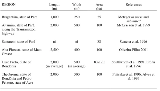
REGION Length
(m)
Width (m)
Area (ha)
References
Bragantina, state of Pará 1,000 250 25 Metzger in press and submitted Altamira, state of Pará,
along the Transamazon highway
2,000 500 100 McCracken et al. 1999
Santarem, state of Pará ni ni 88 Scatena et al. 1996
Alta Floresta, state of Mato Grosso
2,500 400 100 Oliveira-Filho 2001
Ouro Preto, State of Rondônia
2,000 (in average)
500 (in average)
83-120 Southworth et al. 1991, Frohn et al. 1996
Theobroma, state of Rondônia and Pedro Peixoto, state of Acre
2,000 500 100 Fujisaka et al. 1996, Alves et al. 1999
Table 3. Most common lot size and shape in settlement projects from the Brazilian Agency of Colonization (INCRA)
Figure 8 Figure 8
Besides lot size, lot shape should also be considered. On one side, longer lots are ecologically preferable to short ones because they allow the creation of wider forest corridors in the case of EDGE pattern of deforestation. Nevertheless, longer lots are also less attractive for farmers because they imply an average longer journey
500 m
2
,0
0
0
0
m
11 12 13 14 15 16 17 18 19 20 1 2 3 4 5 6 7 8 9 10
ROAD ROAD
Back of the lots
Secondary forests
Agricultural areas Mature forests Number of the lots
However, the main problem today is the obedience to legislation. How can we monitor and control the legislation respect? Despite the actual definition of Legal Reserve of 80%, almost nobody respects this legislation and usually forest is left only along rivers.
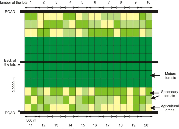
In order to improve the legislation obedience, I propose that future settlements in the Brazilian Amazon should maintain the half-end of the lot as nature-reserve (Figure 9). Whereby, farmers will be allowed to use only half of the lot and will be free to choose their deforestation pattern inside this area. A Legal Reserve of 50% will be guaranteed in each lot and by grouping these LR at the end of the lots the connectivity of the settlement should also be maintained at high levels (Figure 9).
Lot size should be of 100 ha, in order to guarantee 50ha of land per farmer for agricultural purposes. The maintenance of forest at the end of the lot will act as seed sources and also as agricultural pest barriers. The proposed agricultural
between fields and home. Lots of 1500 to 2000m can be good tradeoffs. Usually lot sizes in Brazilian settlement projects varied between 25 and 100 ha and the length varied between 1 and 2 km (Table 3). The most usual lot of 2,000m by 500m (100ha) seems to be ecologically adequate and able to sustain a large family (10 persons) even with a LR of 50%.
Figure 9. Proposed pattern of land use (see text for comments).
management can then be practiced in 25 ha annually.
CONCLUSIONS
In conclusion, the ideal scenario for conservation is the maintenance of 80% of the lot as Legal Reserves and the grouping of LR from different farmers at the end of the lot, using EDGE or HALF-EDGE deforestation patterns. In this scenario, long lots will allow the formation of wide forest corridors.
Considering the regeneration process and in this way the agricultural productivity in slash-and-burn areas, the maintenance of forest is important as a seed source, but small LR will release more land for culture rotation, allowing longer fallow periods. ROW and RANDOM patterns will create more contacts among the landscape units, so facilitating the seed fluxes.
Considering both forest conservation and agricultural productivity, HALF-EDGE pattern of deforestation (or land
11
use) in lots of 2,000m by 500m, with LR of 50% seems to be the best compromise. To guarantee the LR preservation and assemblage, LR should be pre-established when settlements are planned.
ACKNOWLEDGEMENTS
This research work was conducted in the framework of the German-Brazilian program in applied ecosystem research "SHIFT" (Studies on Human Impact on Forests and Floodplains in the Tropics), carried out under the auspices of the Agreement on Cooperation in Scientific Research and Technological Development signed by the governments of the Federal Republic of Germany and the Federative Republic of Brazil. The program is financially supported by BMBF (German Ministry for Education, Science, Research and Technology) and CNPq (Brazilian National Council of Scientific and Technologial Development). The executing institutions of the project "Secondary Forests and Fallow Vegetation in the Eastern Amazon Region - Function and Management", short SHIFT-Capoeira, are the Center for Development Research (ZEF) of the University of Bonn, Germany and the Agroforestry Research Center of the Eastern Amazon, Embrapa Amazônia Oriental, Belém, Brazil. This research was also supported by grants from
o
CNPq (n . 300760/96-5-RE) and Fapesp (São Paulo state
o
Science Foundation, n . 96/10336-9). I thank William Laurance and an anonymous reviewer for valuable comments on an earlier version of the manuscript.
REFERENCES
Alves, D.S., Pereira, J.L.G., de Sousa C.L., Soares, J.V.,Yamaguchi, F., 1999. Characterizing landscape changes in central Rondônia using Landsat TM imagery. International Journal of Remote Sensing 20, 2877-2882.
Attiwill, P.M., 1994. The disturbance of forest ecosystems: the ecological basis for conservative management. For. Ecol. Manage. 63, 247-300.
Beier, P. & Noss, R.F. 1998. Do habitat corridors provide connectivity ? Conservation Biology 12: 1241-1252.
Bellamy, P.E., Hinsley, S.A. & Newton, I. 1996. Local extinctions and recolonisations of passerine bird populations in small woods. Oecologia 108: 64-71. Brondizio, E.S., McCracken, S.D., Moran, E.F., Siqueira,
A.D., Nelson, D.R. and Rodriguez-Pedraza, C. The colonist footprint: towards a conceptual framework of land use and deforestation trajectories among small farmers in frontier Amazônia. In Wood, C. et al. Patterns and processes of land use and forest change in the Amazon. University of Florida Press, Gainsville, in press.
Collinge, S.K. and Forman, R.T.T. 1998. A conceptual model of land conversion processes: predictions and evidence from a microscale experiment with grassland insects. OIKOS 82: 66-84.
Dale, V.H., O'Neill, R.V., Pedlowski, M. and Southworth, F. 1993a. Causes and effects of land-use change in Central Rondônia, Brazil. Photogrammetric Engineering & Remote Sensing 59: 997-1005. Dale, V.H., Southworth, F., O'Neill, R.V., Rosen, A. and
Frohn, R. 1993b. Simulating spatial patterns of land-use change in Rondônia, Brazil. Lectures on Mathematics in the Life Sciences 23: 29-55.
Dale, V.H., O'Neill R.V., Southworth, F. and Pedlowski, M. 1994.Modeling effects of land management in the brazilian amazonian settlement of Rondônia. Conservation Biology 8: 196-206.
Dias, B.F.S. (coord.) 1998. Primeiro relatório nacional para a convenção sobre diversidade biológica (Brasil). Ministério do Meio Ambiente, dos Recursos Hídricos e da Amazônia Legal, Brasília.
Fahrig, L. and Merriam, G. 1985. Habitat patch connectivity and population survival. Ecology 66: 1762-1768.Fahrig, L. and Merriam, G. 1985. Habitat patch connectivity and population survival. Ecology 66: 1762-1768.
Fearnside, P.M. 1999. Biodiversity as an environmental service in Brazil's Amazonian forests: risks, value and conservation. Environmental Conservation 26: 305-321.
Fearnside, P.M. 2000. Global warming and tropical land-use change: Greenholand-use gas emissions from biomass burning, decomposition and soils in forest conversion, shifting cultivation and secondary vegetation. Climatic Change 46: 115-158.
Forman, R.T.T. 1995. Land mosaics: the ecology of landscapes and regions. Cambridge University Press, Cambridge.
Forman, R.T.T. and Mellinger, A.D. 1999. Road networks and forest spatial patterns: comparing cutting-sequence models for forestry and conservation. In Craig, J.L., Mitchell, N. and Saunders, D.A. (eds.). Nature Conservation 5: nature conservation in production environments: managing the matrix. Surrey Beatty & Sons, Chipping Norton, New South Wales, Australia pp. 71-80.
Forman, R.T.T., Galli, A.E. and Leck, C.F. 1976. Forest size and avian diversity in New Jersey woodlots with some land use implications. Oecologia 26: 1-8.
Franklin, J.F. and Forman, R.T.T. 1987. Creating landscape pattern by forest cutting: ecological consequences and principles. Landscape Ecology 1: 5-18.
Frohn, R.C., McGwire, K.C., Dale, V.H. and Estes, J.E. 1996. Using satellite remote sensing analysis to evaluate a socio-economic and ecological model of deforestation in Rondônia, Brazil. Int. J. Remote Sensing 17: 3233-3255.
Brazilian Amazon colonies. Agriculture Ecosystems & Environment 59: 115-130.
Gascon, C. Lovejoy, T. E. Bierregaard Jr., R. O. Malcolm, J. R. Stouffer, P. C. Vasconcelos, H. L. Laurance, W. F. Zimmerman, B. Tocher, M. Borges. S. 1999. Matrix habitat and species richness in tropical forest remnants. Biological Conservation 91: 223-229.
Harper, L. H. 1988. The persistence of ant-following birds in small Amazonian forest fragments. Acta Amazonica. 18: 249-263.
Homma, A.K.O., Walker, R.T., Scatena, F.N., Conto, A.J., Carvalho, R., Rocha, A.C.P.N., Ferreira, C.A.P., Santos, A.I.M., 1993. Dynamics of deforestation and burning in Amazonia: a microeconomic analysis. Overseas Development Institute, Rural Development Forestry Network, Network Paper 16c. Regent's College, Regent's Park, London. Instituto Nacional de Colonização e Reforma Agrária
(INCRA), 1996. Dossiê, Divisão de Assentamentos (Porto Velho) (Working report, December 1998). Instituto Nacional de Pesquisas Espaciais (INPE). 1999.
Monitoramento da floresta amazônica por satélite (1997-1998). INPE-7989-RPQ/714, Ministério de Ciência e Tecnologia, São José dos Campos, SP. Kato M.S.A., Kato, O.R., Denich, M., Vlek, P.L.G. 1999.
Fire-free alternatives to slash-and-burn for shifting cultivation in the eastern Amazon region: the role of fertilizers. Field crops research 62: 225-237. Laurance, W.F. 2000. Mega-development trends in the
Amazon: Implications for global change. Environmental Monitoring and Assessment 61: 113-122.
Laurance, W.F., Cochrane, M.A., Bergen, S., Fearnside, P.M., Delamônica, P., Barber, C., D'Angelo, S. and Fernandes, T. 2001. The future of Brazilian Amazon. Science 291: 438-439.
Laurance, W.F. & Bierregaard, R.O., Jr. (Eds.). 1997. Tropical forest remnants: ecology, management, and conservation of fragmented communities. The University of Chicago Press, Chicago & London. Laurance, W.F., Laurance, S.G., Ferreira, L.V., Rankin-de
Merona, J.M., Gascon, C. & Lovejoy, T.E. 1997. Biomass collapse in Amazonian forest fragments. Science 278: 1117-1118.
Laurance, W.F., Laurance S.G. and Delamonica, P. 1998a. Tropical forest fragmentation and greenhouse gas emissions. Forest Ecology and Management 110: 173-180.
Laurance W.F., Ferreira L.V., Rankin-De Merona J.M. and Laurance, S.G. 1998b. Rain forest fragmentation and the dynamics of Amazonian tree communities. Ecology 79: 2032-2040.
Li, H., Franklin, J.F., Swanson, F.J. and Spies, T.A. 1993. Developing alternative forest cutting patterns: a simulation approach. Landscape Ecology 8: 63-75. Lindenmayer D.B., Margules C.R., Botkin D.B. 2000.
Indicators of biodiversity for ecologically sustainable forest management. Conservation Biology 14: 941-950.
McCracken, S., Brondizio, E.S., Nelson, D., Moran, E.F., Siqueira, A.D. and Rodriguez-Pedraza, C. 1999. Remote sensing and GIS at farm property level: demography and deforestation in the Brazilian Amazon. Photogrammetric Engineering & Remote Sensing 65: 1311-1320.
McGarigal, K. & Marks, B.J. 1995. FRAGSTATS: spatial pattern analysis program for quantifying landscape structure. U.S. Forest Service General Technical Report PNW 351.
Metzger, J.P. 2000. Tree functional group richness and spatial structure in a tropical fragmented landscape (SE Brazil). Ecological Applications, 10: 1147-1161.
Metzger, J.P. Landscape dynamic and equilibrium in areas of slash-and-burn agriculture with short and long fallow period (Bragantina region, NE Brazilian Amazon). Landscape Ecology, in press.
Metzger, J.P. Effect of fallow period on the landscape structure at site and property levels (Bragantina region, NE Amazon, Brazil). Submitted.
Metzger, J.P. & Muller, E. 1996. Characterizing the complexity of landscape boundaries by remote sensing. Landscape Ecology 11: 65-77.
Metzger, J.P. & Décamps, H. 1997. The structural connectivity threshold: an hypothesis in conservation biology at the landscape scale. Acta Œcologica 18: 1-12.
Moran, E. F., Brondizio, E.S. and McCracken, S. Trajectories of land use: soils, succession, and crop choice. In Wood, C. et al. Patterns and processes of land use and forest change in the Amazon. University of Florida Press, Gainsville, in press. Murcia, C. 1995. Edge effects in fragmented forests:
implications for conservation. TREE 10: 58-62 Nepstad, D.C., Moutinho, P.R., Uhl, C., Vieira, I.C. and
Silva, J.M.C. 1996. The ecological importance of forest remnants in an Eastern Amazonian frontier landscape. In Forest patches in tropical landscapes, pp. 133-150. Edited by Schellas, J. and Greenberg, R. Is land press: Washington, D.C.
Oliveira-Filho, F.J.B. 2001. Padrão de desmatamento e evolução da estrutura da paisagem em Alta Floresta (MT). Master Thesis, University of São Paulo, SP, Brazil.
Penteado, A.R. 1967. Problemas de colonização e de uso da terra na região Bragantina do Estado do Pará. Coleção Amazônica, Série José Veríssimo, Universidade Federal do Pará: Pará, PA.
Title: Effects of deforestation pattern and private nature reserves on the forest conservation in settlement areas of the Brazilian Amazon
Author: Jean Paul Metzger - ISSN 1676-0611
Biota Neotropica, Volume 1, números 1 e 2, 2001 - http://www.biotaneotropica.org.br/v1n12/pt/abstract?arti
cle+BN00101122001
Date Received: Aug. 01, 2001 - Accepted: Sept. 05, 2001 Peres, C.A. and Terborgh, J.W. 1995. Amazonian
nature-reserves: an analysis of the defensibility status of existing conservation units and design criteria for the future. Conservation Biology 9: 34-46.
Purata, S.E., 1986. Floristic and structural changes during old-field succession in the Mexican tropics in relation to site history and species availability. J. Trop. Ecol. 2, 257-276.
Quintana-Ascencio, P.F., González-Espinosa, M., Ramirez-Marcial, N., Dominguez-Vázquez, G., Martinez-Icó, M., 1996. Soil seed banks and regeneration of tropical rain forest from milpa fields at the Selva Lacandona, Chiapas, Mexico. Biotropica 28, 192-209.
Rolstad, J. 1991. Consequences of forest fragmentation for the dynamics of bird populations: conceptual issues and the evidence. Biological Journal - Linnean Society 41: 149-163.
Rosenberg, D.K., Noon, B.R. & Meslow, E.C. 1997. Biological corridors: form, function, and efficacy. BioScience 47: 677-687.
Saulei, S.M., Swaine, M.D., 1988. Dynamics of seed rain and soil seed banks during forest clearance and subsequent regrowth in the Gogol Valley, Papua New Guinea. J. Ecol. 76, 133-152.
Saunders, D.A., Hobbs, R.J. & Margules, C.R. 1991. B i o l o g i c a l c o n s e q u e n c e s o f e c o s y s t e m fragmentation: a review. Conservation Biology 5: 18-32.
Scatena, F.N., Walker, R.T., Homma, A.K.O., de Conto, A.J., Ferreira, C.A.P., Carvalho, R.D., da Rocha A.C.P.N., Santos, A.I.M.D., de Oliveira, P.M. 1996. Cropping and fallowing sequences of small farms in the ''terra firme'' landscape of the Brazilian Amazon: A case study from Santarém, Pará. Ecological Economics 18: 29-40.
Seagle, S.W. 1986. Generation of species-area curves by a model of animal-habitat dynamics. In: Verner, M.L., Morrisson, M.L. & Ralph, C.J. (Eds.), Wildlife 2000. Modeling habitat relationships of terrestrial vertebrates. The University of Wisconsin Press, Madison, Wisconsin, p. 281-285.
Serra, J. 1982. Image analysis and mathematics morphology. Academic press, New York.
Serrão, E.A.S., Nepstad, D. and Walker, R. 1996. Upland agricultural and forestry development in the Amazon: sustainability, criticality and resilience. Ecological Economics 18: 3-13.