.ufc.br
Copyright © 2002, Universidade Federal do Ceará
IMPACT OF RURAL SETTLEMENTS ON THE
DEFORESTATION OF THE AMAZON
Article history:
Received 06 October
, 2017
Accepted 09 November
, 2017
Publisher 15 May
, 2018
ABSTRACT
In recent years, it is possible to realize a change in the profile of deforestation in the Amazon, reflecting increasing rates of “little deforestations”, result from the diversification of productive activities related to family farming. In the Amazon, the state of Pará stands out for its strategic location when considering the Arc of Deforestation in advance, and also for its contribution in the distribution of lands by the Agrarian Reform, whose settlements add 1.055 units and 221.04 families installed. In this context, this paper aims to investigate the influence of the settlement projects of agrarian reform have on deforestation in the city of Novo Repartimento (PA) from 2000 to 2013.
Keywords: Settlement; Conservation; Deforestation; Dynamics.
RESUMO / RESUMEN
IMPACTO DOS ASSENTAMENTOS RURAIS NO DESMATAMENTO DA AMAZÔNIA
Nos últimos anos, percebeu-se uma mudança no perfil do desmatamento na Amazônia, evidenciando índices crescentes de pequenos desmatamentos, decorrentes da diversificação das atividades produtivas relacionadas à agricultura familiar. Na Amazônia, o estado do Pará se destaca por sua localização estratégica quando se considera o avanço do Arco do Desmatamento, e também pela sua contribuição na distribuição de terras de Reforma Agrária, cujos assentamentos somam-se atualmente 1.055 unidades e 221.804 famílias instaladas. Diante deste contexto, este trabalho tem como objetivo investigar a influência que os projetos de assentamentos de Reforma Agrária têm sobre o desmatamento no município de Novo Repartimento (PA) no período de 2000 a 2013.
Palavras-chave: Assentamento; Conservação; Desmatamento; Dinâmica.
IMPACTO DE LOS ASENTAMIENTOS RURALES EN LA DEFORESTACIÓN DEL AMAZONAS
En los últimos años, se percibió un cambio en el perfil de la deforestación en la Amazonia, evidenciando índices crecientes de pequeños desmontes, resultantes de la diversificación de las actividades producti
-vas relacionadas a la agricultura familiar. En la Amazonia, el estado de Pará se destaca por su ubicación estratégica cuando se considera el avance del Arco de la Deforestación, y también por su contribución en la distribución de tierras de Reforma Agraria, cuyos asentamientos se suman actualmente 1.055 unidades y 221.804 familias instaladas. En este contexto, este trabajo tiene como objetivo investigar la influencia que los proyectos de asentamientos de Reforma Agraria tienen sobre la deforestación en el municipio de Novo Repartición (PA) en el período de 2000 a 2013.
Palabras clave: Asentamiento; Conservación; Deforestación; Dinámica.
.
(*)CORRESPONDING AUTHOR
Address: UEPA - Avenida Gentil Bittencourt. CEP: 66040172 - Belém (PA), Brasil. Tel: (+55 91) 33232550 E-mail: [email protected]
(a) Master in Production Engineering. Lecteur State University of Pará (UEPA), Belém, (PA), Brazil. ORCID ID:
https://orcid.org/0000-0002-3046-272X. CURRICULUM LATTES: http://lattes.cnpq.br/1815049617982560
(b) Phd in Agricultural Economics. Professor State University of Pará (UEPA), Belém, (PA), Brazil. ORCID ID:
https://orcid.org/0000-0003-1991-2977. CURRICULUM LATTES: http://lattes.cnpq.br/9434131723316393
(c) Master in Meteorology. Federal University of Viçosa (UFV), Viçosa (MG), Brazil. ORCID ID: https://orcid.org/0000-0003-3240-7238.
CUR-RICULUM LATTES: http://lattes.cnpq.br/1612541588794395
(d) Phd in Agrarian Sciences. Professor Federal University of Pará (UFPA), Belém, (PA), Brazil. ORCID ID:
https://orcid.org/0000-0003-0596-002X. CURRICULUM LATTES: http://lattes.cnpq.br/8271393778032215
FARIAS, Monique Helen Cravo Soares; a * BELTRÃO, Norma Ely Santos; b
www
.mercator
INTRODUCTION
The Amazon is the largest continuous remnant of the Earth’s rainforest, covering about 6 million square kilometers and bordering nine countries. In Brazil, the region is characterized by high cultural and biological diversity (Barlow et al., 2011; ROSA et al., 2013). Globally, the Amazon stands out as one of the main emitters of carbon dioxide (CO2) in the class of Land-use Change, especially deforestation, as it holds about a tenth of the global carbon in terrestrial ecosystems and an equal share in global net primary production (GALFORD et al.., 2013).
According to Coy & Klinger (2014), the dynamics of the regional development of Eastern Amazonia, which until the 1970s was considered a peripheral region, was radically altered due to socioeconomic, cultural, political and spatial changes, as well as socio-environmental problems that have resulted from these processes. The changes that took place and the resulting conflicts began in the 1960s, starting with the formation of a pioneering front-line dynamic led by the State, composed of large infrastructure projects and settlements, with the aim of occupying, clearing, deforesting and thus adding value to the land in the theoretical sense of modernization. Despite the emphasis on natural wealth, the absence of land-use planning has hampered the sustainable appropriation of resources (MACEDO et al., 2013).
Diniz et al. (2013) point out that, in the last decades, hundreds of thousands of families settled in the Brazilian Amazon within the scope of the Agrarian Reform Program, a program that allows the colonists to earn a living through small-scale agriculture and the Agrarian Reform Settlement Projects (PAs), which resulted in more than 8,500 settlements in the period from 1970 to 2013, covering more than 84 million hectares throughout the country; almost 90% of the total settlement area is in the states of the Amazon Region (EZZINE-DE-BLAS et al., 2011).
Still in the ambit of the significant changes that have occurred in the Legal Amazon in recent years, it has been observed that in this period there has been a change in the profile of deforestation in the Amazon, which currently has increasing rates of small-scale deforestation (forest degradation associated with small sequential deforestation), due to the diversification of productive activities related to family farming (RETTMANN, 2013). In the Amazon, the state of Pará is notable for its strategic location when considering the advance of the Deforestation Arc. It is one of the most deforested regions in Brazil, due to the great changes in the natural landscapes resulting from agri -cultural expansion (BRASIL et al., 2014), and also because of its contribution to Agrarian Reform land distribution, whose settlements total 1,055 units and 221,804 families installed by 2013, the largest area of settlement projects among the Amazonian states.
In view of this context, as the state is an important agent of Agrarian Policy and Combating Deforestation, both applied to the same territory, and aiming to fill the scientific gap regarding the treatment of these relationships, our objective is to investigate the influence that the Agrarian Reform settlement projects have had on deforestation in the municipality of Novo Repartimento (PA) from 2000 to 2013. The municipality was chosen as it is included in MMA Ordinance No. 28/02008, which listed the first thirty-six priority municipalities, since it is considered a priority municipality by the Plan of Action for Prevention and Control of Deforestation in the Legal Amazon (PPCDAm 2012-2015) and, according to the methodology of the Green Municipalities Program (PMV), where it is classified as an “Embargoed Municipality”. It also occupies the fifth position in the ranking of the most deforesting municipalities of Pará, according to data from the Amazon Forest Deforestation Calculation Program (PRODES / INPE), related to 2013.
.ufc.br
THEORETICAL REFERENCE
LAND USE DYNAMICS AND THE IMPACTS OF DEFORESTATION IN THE
AMAZON
Throughout its history the Amazon has undergone an intense process of transformation in its form and content, causing different social, political and economic elements to modify its space. Thus, through the interpretation of the current land use and cover, it is possible to verify how the different actors and policies involved were associated in each specific moment in history and cur -rently reflected in the space (SILVA et al., 2013).
The gradual transformation of the Amazon Rainforest has created a vast area with rapid de -clining forest cover in the form of a large arc that runs from the westernmost part of the State of Acre, through the transverse region of southern Amazonas, southern Pará and northern Rondônia, and Mato Grosso to the border of the State of Pará with the states of Tocantins and Maranhão (GOMEZ et al., 2015).
For Soares Filho et al. (2005), the historical and present causes of deforestation in the Amazon are varied and often interrelated, especially: changes in agricultural commodity prices and related government policies (FERREIRA & COELHO, 2015); the expansion of livestock farming (SILVA, 2014; VALE, 2015); the advance of logging (BECKER, 2013; VERÍSSIMO & PEREIRA, 2014); and investments in infrastructure (SOUZA et al., 2015). The Agrarian Reform projects are also pointed to as a pressure for deforestation and are approached in the works of Fearnside (2005), Le Torneau & Bursztyn (2010), Calandino et al. (2012), Duchelle et al. (2014) and Reydon et al. (2015).
One of the assumptions of the Action Plan for the Prevention and Control of Deforestation in the Legal Amazon - PPCDAm (MMA, 2013), is that the deforestation process in the Amazon is not homogeneous, varying according to the different parts of the region and over time. It is estimated that by 1980 deforestation had reached about 30 million hectares, equivalent to 6% of its total area. In the 1980s and 1990s, some 28 million hectares were incorporated into the deforested area. In the early years of the last decade, the pace intensified, amounting to an accumulated area of ap -proximately 67 million hectares in 2004, equivalent to ap-proximately 16% of the forest area of the Legal Amazon, seriously threatening the process of sustainable development in the region. From 2004 onwards, with the launch of the PPCDAm, the annual deforestation rate reduced drastically, reaching 641,800 hectares for the period 2010-2011, according to PRODES data and generating, according to recent data, an area of accumulated deforestation of about 18% of the region’s forest (about 74,800,000 hectares). In 2012, the rate of deforestation reached the lowest historical value of the INPE monitoring series, reaching 457,100 hectares. Thus, considering the environmental characteristics and their different forms of occupation, the existence of a large number of possible determinants of the deforestation process in the region is evident.
In this sense, Boucher et al. (2013), when analyzing the dynamics of deforestation rates in the Amazon from 1988 to 2011, associated to the performance of the soybean and beef industries, concluded that there has been a greater reduction in deforestation in recent times, despite significant pressures in the opposite direction.
Börner et al. (2015) suggest that changes in the strategy for applying Brazilian law and the related governance system may account for a large part of the global success in curbing deforesta -tion rates, despite the rapid growth of soybeans and ranching in the first decade of the twenty-first century. At the same time, Brazil is experimenting with alternative approaches to compensate far -mers for conservation actions through economic incentives, such as payments for environmental services in the various administrative spheres.
www
.mercator
institutions to cope with the environmental reality in the Amazon.
Forest cover in areas destined for rural settlements in the Brazilian Amazon has also been in-tensely deforested or affected by forest degradation. Although established to provide housing and sustainable production to families who do not have the economic means to acquire a property, it is observed that the focus of agrarian reform as a policy involving territorial, social and economic strategies has been diverted (Yanai et al.).
SETTLEMENT PROJECTS IN THE AMAZON
Agrarian Reform was officially established as a matter of importance to the government after the enactment of the Land Statute, Law No. 4504 of November 30, 1964. The Law, according to its Article 1, had the function of regulating rights and obligations concerning rural property, for the purposes of implementing the reform and the promotion of the Agricultural Policy (LIMA et al., 2011). In 1985, the proposal for a National Policy on Agrarian Reform (PNRA), based on the Land Statute, aimed to establish priority areas. However, the reaction of anti-reform forces led to this idea being abandoned (HEREDIA et al., 2013).
Continuing this process, Curado (2014) stated that the increase in the number of settlements, the growing demand for more land from the large contingent of families evicted from the country -side by “conservative modernization”, in addition to the swelling of the cities and the increased of rates of urban and rural unemployment, demanded more attention to the conditions necessary for the economic viability of the settlement projects.
For Pacheco (2009), Agrarian Reform tends to promote the redistribution of land through the regularization of land invasions of latifundium by small landowners on a large scale, and the redistribution of public land to small farmers in existing colonization frontiers. The implications of state-led agrarian reform for deforestation are heterogeneous, generating impacts strongly related to the preexisting social and economic configuration of the borders where it occurs.
From this point, Batistella and Brondízio (2001) declare that few political initiatives have the social, economic and environmental relevance as the rural colonization projects in the Amazon. In the history of these settlements is written the success or failure of thousands of families, issues of rural development and food production, the creation of infrastructure and the dynamics of defo -restation and occupation of that immense region of diverse vocations. Numerous factors affect the process, such as the productive potential of soils, the demand for land, land conflicts, public policies, and the internal and external market regime, among others. Colonization and national integration projects laid the foundation for the settlements in the Amazon. Initially, the Brazilian government promoted the Amazon as the land of opportunity and families from all over Brazil, especially from the Northeast, migrated to this new frontier area. In order to regularize the land occupation of these new settlers, the federal government created the National Institute of Colonization and Agrarian Reform (INCRA) in the year 1970 (CROMBERG et al. 2014).
Most of the families that migrated to the region were motivated by the supply of land and subsidized credit, and were mostly distributed in INCRA settlements, concentrated along the Trans --Amazonian Highway, in the State of Pará and around the BR-364 highway in Rondônia (BRAN -DÃO JÚNIOR & SILVA JÚNIOR, 2006).
One particular feature of Amazonian rural economies is the interaction between agriculture and forest management. Government sponsorship of the colonization of the Brazilian Amazon began in the early 1970s and led to the creation of more than 50 million hectares of agrarian settlements occupied by small farmers (SIST et al., 2014). This implementation in previously unoccupied are -as of the Brazilian Amazon h-as been -associated with high levels of forest loss and unclear social outcomes over time (GUEDES et al., 2014).
.ufc.br
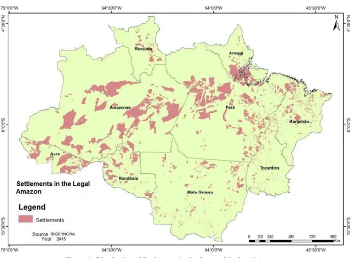
which shall establish and ensure the implementation of the rules for the use of natural resources, especially forest ones (SANTOS et al, 2010). This can be illustrated by the creation of about 3,417 settlements in the Amazon from 1970 to 2013, whose area amounts to 71,700,253.26 hectares, concentrated along the main highways and the Deforestation Arc, as shown in Figure 1
.
Figure 1- Distribution of Settlements in the States of the Legal Amazon. Source: IBGE / INCRA, 2013.
It is important to highlight the distribution of settlements among states in the Legal Amazon:, the state of Pará has the largest number (34%), of the 3,417 settlements identified, followed by Maranhão (22%) and Mato Grosso (13%). The other settlements (31%) are distributed in the other States of the Legal Amazon, whose numbers are shown in Table 1, below.
Table 1 - Number of Settlements by State in the Legal Amazon
LEGAL AMAZON
States Number of Settlements Number of Families Settled
Acre 159 32,896
Amapá 50 14,749
Amazonas 144 56,141
Maranhão 802 111,513
Mato Grosso 546 83,323
Pará 1,055 221,804
Rondônia 217 38,772
Roraima 67 16,654
Tocantins 377 23,984
Total 3,417 599,836
www
.mercator
By 2013, the final period of analysis, 599,836 families were settled in the states of the Ama-zon. The implications of the changes in land use, with an emphasis on deforestation due to the development of productive activities and subsistence of these families, are relevant and deserve to be investigated. Therefore, before making the spatial cut-off in the municipality of Novo Reparti -mento, the issue of deforestation in settlement areas in Amazonia is discussed below, evidencing the findings from the bibliography researched.
DEFORESTATION IN SETTLEMENTS IN THE AMAZON
Knowing that the dynamics of deforestation is unique to each state of the Amazon, derived from differentiated land policies and formation processes, besides the heterogeneity of environments, we can now highlight the action of small rural producers who live in settlement projects on the occur -rence of deforestation in the Amazon (RETTMANN, 2013). Despite being considered a causative agent of deforestation, it is still necessary to deepen this theme, to understand the different factors that interfere in land use behavior and, consequently, deforestation in the region.
Several studies have been carried out to verify the deforestation caused by agrarian reform settlements in the Amazon Region, especially after the Ministry of the Environment (MMA) an -nounced in 2008 that the INCRA settlement projects were among the top six on the list of those responsible for the deforestation of the Amazon (CALANDINO et al., 2012).
The main concern revolved around the extent of deforestation detected in settlements, as ac -cording to Le Torneau and Bursztyn (2010), settlement areas have become one of the main elements of the rural world in the Legal Amazon, accounting for almost a third of the land under use and almost 74% of rural establishments.
Soares (2008) points to the fact that most of the projects do not have any planning and the areas chosen to establish settlements are not selected for their agronomic characteristics. In addition, the settlers’ knowledge about environmental legislation is sparse, so they will hardly be able to respect the Permanent Preservation Areas (APP) or Legal Reserves (RL), thus promoting the occurrence of illegal deforestation.
For Fatorelli and Mertens (2010), the planning of the agricultural, economic and social di -mensions of the settlements, and their structural distribution and Legal Reserve status is one of the most important instruments of rural environmental management. Lack of planning can create serious problems in settlements, such as economic bankruptcy, illegal deforestation, agricultural inefficiency, etc. As regards INCRA’s actions, Homma et al. (2001) show that settlement projects in the southeast of Pará, the Settlement Projects, have been much more about regularizing consum -mated facts of invasions in the face of the aggressiveness of the occupation process. The continuous flow of migrants makes it practically impossible to have a planned occupation action: the projects do not obey any environmental or agricultural zoning criteria; and there is an absence of adequate technological practices. In this sense, without the support of technical assistance these occupations formed their own definition of economic alternatives and appropriate infrastructure. The number of settlers only serves to fatten the figures of Brazilian Agrarian Reform, guaranteeing a partial solution for the migrants and the national land issue.
It is evident that this program was incorporated into a floating policy and economic environ -ment characterized by attractive rural credits, subsidies of agrarian production and the expansion of transport infrastructure that contributed to shaping
.ufc.br
this is environmental damage, such as the formation of degraded areas and the retraction of forest remnants, which end up being reflected in the producers’ day-to-day.
PUBLIC POLICIES TO COMBAT DEFORESTATIO.
Already presented throughout this text, the Plan for the Prevention and Control of Deforesta -tion in the Legal Amazon (PPCDAM) is a reference in Brazil in terms of Public Policy to combat deforestation. Launched in 2004, its conception was in Brazil’s uncomfortable position as one of the world’s largest emitters of carbon dioxide (COY & KLINGER, 2014).
According to Abranches (2014), the plan presented a clear and frank diagnosis of the causes of deforestation. It pointed to livestock farming, soy production, illegal logging, infrastructure works and Agrarian Reform settlements as the critical factors of deforestation. In its third phase of implementation (2012-2015), it sought to demonstrate the relative contribution of territorial categories to deforestation in the Amazon region after 2004, when the PPCDAm activities began. It was found that the settlements were also reducing deforestation, but not at the same intensity as the other territorial categories. This analysis subsidized the elaboration of the Plan of Prevention, Combat and Alternatives to Illegal Deforestation in Settlements of the Amazon, the “Green Settle -ments Program”, instituted by the INCRA Ordinance n ° 716/2012. It had the following principles: adding value to environmental assets and productive activities, with an emphasis on environmentally differentiated settlement projects; recovering environmental liabilities with income generation and food security for families; environmental and land regularization, using the CAR as an instrument of environmental regularization; and environmental monitoring / controlling and management of the Plan (MMA, 2013).
However, despite the efforts to develop the first phase of the PPCDAm, Cabral & Gurgel (2014) point out that the deforestation rate started to rise again in the Amazon from the second half of 2007. With this, the government accelerated the signing of Decree No. 6,321, on December 21, 2007, which established a set of measures to control deforestation, such as: an edition of the list of municipalities considered as a priority for environmental and land control actions, prohibiting the issuance of new deforestation authorizations and the possibility for INCRA to promote the re--registration of rural properties; and the mandatory embargoes of illegally deforested areas.
On May 25, 2012, the New Brazilian Forest Code was launched, with the objective of esta -blishing general rules on the protection of vegetation, Permanent Preservation Areas and Legal Reserve areas, use of the forest, the supply of raw materials from the forest, control of the origin of forest products and the control and prevention of forest fires. Economic and financial instruments were provided to achieve these objectives. The Code also established innovative instruments to promote forestry activity and to monitor its implementation. Among these instruments is the Rural Environmental Registry (CAR), an electronic public record, of a declaratory and mandatory nature to be applied to all rural properties in the country. Its function is to generate environmental infor -mation about rural properties, so as to enable “control, monitoring, environmental and economic planning and combat deforestation” throughout the country (AZEVEDO et al., 2014).
www
.mercator
METHODOLOGICAL PROCEDURES
RESEARCH TYPE
Descriptive exploratory research was used in order to materialize the objectives proposed in this study, restricted to the settlements located in the city of Novo Repartimento, State of Pará. Ac-cording to Beuren (2004), with an exploratory study, the aim is to gain a more in-depth knowledge of the subject in order to clarify it or to construct important questions for conducting the research. For Gil (2002), it provides a greater familiarity with the problem, with a view to making it more explicit or to create hypotheses. These motivations are observed in the design of this research, which aims to investigate a possible relationship between Agrarian Reform settlement projects and the occurrence of deforestation in the study area.
As for the approach, this work is classified as quantitative research since, according to Martins & Bicudo (2005), its theme deals with facts, with everything that can become objective through systematic observation. This statement can be verified from the data collection to get to know the deforestation profile of the municipality and the region in which it is inserted.
DESCRIPTION OF THE STUDY AREA
Considering the objectives of this research, as well as the focus on the relationship between Agrarian Reform Policy and the dynamics of deforestation, a study area in the State of Pará was defined, with the characteristics of a recent and marked dynamic of occupation that contained set -tlement projects of the National Institute of Colonization and Agrarian Reform (INCRA) and, at the same time, presented a significant change in terms of vegetation cover removal, in order to support the identification and characterization of deforestation in settlement projects.
Throughout the State of Pará, there are currently 1,055 Federal Rural Settlement Projects, which were created and are managed by INCRA. These settlements shelter 221,804 families, occupying an area of approximately 16.8 million hectares.
In this context, this research was developed in the municipality of Novo Repartimento, in the Tucuruí Region of Integration, in the southeast of the state (Figure 2). Its area covers 1,539,800 hectares, and houses 62,050 inhabitants, of whom 45% are in the urban area and 55% in the rural area (IDESP, 2012). The municipality contains totally or partially, 1 Indigenous Land (TI), 3 Con -servation Units (UC’s) and 31 Settlement Projects (PA’s) (IMAZON, 2014).
DATA COLLECTION
The theoretical and conceptual aspects of the dynamics of deforestation in settlement projects were obtained through the analysis of national and international scientific articles, legislation and institutional reports and publications.
Initially, official data were collected on existing Settlement Projects in the Amazon Region, in the State of Pará and in the municipality of Novo Repartimento in the Panel of Settlements, located in the Portal of the National Institute of Agrarian Reform (INCRA), with a view to subsidizing the research with consolidated information on the number of existing settlements, the distribution of settlements by States belonging to the Legal Amazon, occupied areas, the number of settled families, date on the creation and status of the settlement.
Subsequently, data were obtained on the municipality’s link to the Green Municipalities Pro -gram, with a view to subsidizing the research with data on targets to combat deforestation, registrable areas, the implementation of the Rural Environmental Register (CAR) and municipal environmental management. This information was obtained through the Green Municipalities Program Portal.
.ufc.br
Calculation Program (PRODES / INPE). Piketty et al. (2015) explain that the PRODES method measures the extent of annual deforestation in the Legal Amazon from a mean spatial resolution (pixel size: 0.36 Ha), comprising a classification system based on the mixed spectral model appro -ach and using remote sensing data (Landsat 8 satellite imagery). E-ach year, PRODES establishes two main land cover classes for the entire Legal Amazon: forest and deforestation, as well as other classes including no forest, hydrology or clouds. In order to obtain images of the settlements a search was conducted for files in the INCRA Land Collection.
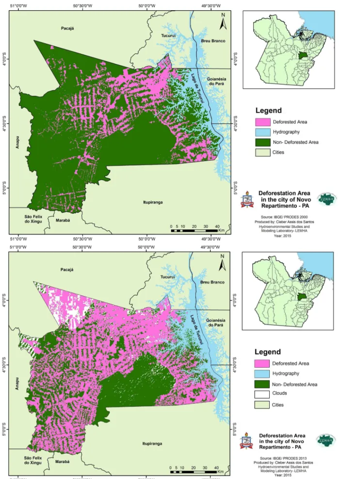
Figure 2 - Location of Novo Repartimento (Pará). Source: IBGE / Landsat, 2015.
Based on orbital images from the Landsat 5 satellites (images referring to the year 2000) and Landsat 8 (images referring to the year 2013), and from supervised classification, it was possible to create shapes defining the areas of settlements in the municipality of Novo Repartimento.
Based on cartographic data from PRODES and the perimeters of settlement areas, ARCGIS 10.0 software was used to design the settlement areas affected by deforestation. After the crossing of shapes, we set out to identify and calculate the areas of deforestation in hectares.
DATA ANALYSIS
THE CONTEXT OF NOVO REPARTIMENTO
www
.mercator
Tucuruí reservoir, part of the Pucuruí reserve where the Indians lived was flooded; the remaining area was cut by the construction of the Trans Amazonian bypass (BR-230). In 1981, land located near the eastern border of the old Parakanã reserve was used to relocate expropriated peasants who were mostly settlers evicted from the margins of the original Trans Amazonian highway. They were migrants from all over the country, who moved to the Amazon in the 1970s, driven by federal go -vernment incentives and promises of land and subsidies for agriculture and housing (ACSELRAD & SILVA, 2011).
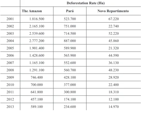
Located in the Tucuruí Reservoir Region (PA) in an area of tropical forest where the climate, according to the Köpen climatic classification method, is tropical humid, this municipality has an area of 1,539,130 hectares, and the analysis of its deforestation dynamics only occurred in 2001, according to the Amazon Deforestation Calculation Program (PRODES / INPE).
In the period from 2001 to 2013, 745,570 hectares of deforested areas were detected in Novo Repartimento. The advance of deforestation in the municipality followed the growth trends faced by the State of Pará and by the other territories of the Legal Amazon, where the highest rates refer to the period prior to 2008, as shown in table 2.
Table 2 - Comparison of the Dynamics of Deforestation (2001-2013)
Deforestation Rate (Ha)
The Amazon Pará Novo Repartimento
2001 1.816.500 523.700 67.220
2002 2.165.100 751.000 22.740
2003 2.539.600 714.500 52.220
2004 2.777.200 887.000 45.860
2005 1.901.400 589.900 21.320
2006 1.428.600 565.900 44.590
2007 1.165.100 552.600 36.130
2008 1.291.100 560.700 48.230
2009 746.400 428.100 28.920
2010 700.000 377.000 22.400
2011 641.800 300.800 18.310
2012 457.100 174.100 12.100
2013 589.100 234.600 14.970
Source: PRODES, 2013.
In the year 2000, the starting point of the study period, the municipality had 1,115,700 hectares of forest, representing 72.3% of its total area. In the PRODES analysis, which verified the availability of forest area compared to other municipalities in the state, Novo Repartimento ranked 15th among the cities that most deforested the state of Pará that year. Although there has been a reduction in the increase in deforestation since 2008, in 2013 there were only 599,890 hectares of forest remaining, equivalent to approximately 38.87% of the forested area of the municipality, as shown in figure 3, thus placing it in the 5th position among the municipalities with the most deforestation, which may jeopardize the sustainable development of the region.
Alterna-.ufc.br
www
.mercator
tives to Deforestation (PPCAD Pará) and the Green Municipalities Program; command and control actions to increase monitoring in the field and the launch of the Deter (INPE) and SAD (IMAZON) real-time satellite monitoring systems and satellite monitoring systems.
Even with this gradual reduction in deforestation rates as of 2009, the calculation of all the areas affected by deforestation has shown that by 2013 the municipality of Novo Repartimento had lost about 48% of its forest cover.
Table 3 - Deforestation Data in New Repartition
Deforestation Area (total accumulated) % in relation to the Total Area of the Municipality
Until 00 310,580 20.13%
2002 400,540 25.96%
2004 498,620 32.31%
2006 564,520 36.58%
2008 648,880 42.05%
2010 700,200 45.37%
2012 730,610 34
2013 745,570 48.31%
Source: PRODES, 2013.
SETTLEMENT PROJECTS IN THE MUNICIPALITY OF NOVO
REPARTIMENTO (PA)
Pará emerges as the state of the Legal Amazon with the most settlement projects in its ter -ritory. Consisting of 144 municipalities, 102 of these have settlement projects in their territories. According to a classification defined by the National Institute of Colonization and Agrarian Reform (INCRA), these municipalities are grouped into 3 Regional Superintendencies: SR no. 01 - Belém, which includes 45 municipalities; SR no. 27 - Marabá, composed of 37 municipalities, including Novo Repartimento; and SR no. 30- Santarém, which has 20 municipalities.
Chart 1 - Classification of Settlement Projects - SR 27 (Pará / Marabá)
Number of Settlements in the Municipalities of SR 27
0-10 11-20 21-30 31-40 Mais de 40
Bannach Bom Jesus do Tocantins Brejo Grande do Araguaia
Breu Branco
Cannãa dos Carajás Cumaru do Norte Curionópolis
Floresta do Araguaia Goianésia do Pará Jacundá
Nova Ipixuna
Ourilândia do Norte Palestina do Pará Parauapebas
Pau D’Arco Portel São João do Araguaia
Tucumã Tucuruí
Água Azul do Norte Baião Pacajá Piçarra Redenção
Rio Maria Rondon do Pará Santana do Araguaia São Domingos do Araguaia
São Félix do Xingu Xinguara
Eldorado do Carajás Santa Maria das
Barreiras São Geraldo do
Araguaia Conceição do Araguaia Itupiranga Novo Repartimento Marabá
Source: INCRA, 2013.
.ufc.br
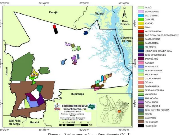
Figure 4 - Settlements in Novo Repartimento (2013). Source: IBGE / INCRA, 2013.
Table 4 - Detailing of Novo Repartimento’s Settlement Projects
Settlement Area (ha) Date Created N° of Families
(Capacity)
N° of Families Settled
Tuerê 102578,1 04/08/1987 2988 2955
Rio Gelado 166673,0 02/09/1992 2500 2500
Sagitário 2428,8 12/11/1992 43 37
Redenção 2992,9 26/09/1996 70 50
José Martins Pessoa 2009,5 27/05/1998 41 41
Cocalândia 4021,5 27/05/1998 96 94
Jaguatiara 3054,3 27/05/1998 60 59
Manuelito 2507,4 14/01/1999 75 62
Serra Quebrada 2140,8 04/02/1999 45 44
Santa Amélia 1941,6 04/02/1999 73 49
Cigana 1895,1 04/02/1999 27 27
São Gabriel 2377,0 04/02/1999 44 40
Pajeú 2723,9 22/09/1999 52 52
Santa Izabel 2318,0 22/09/1999 77 76
Alto Pacajá 13201,2 05/12/2001 138 138
Boca Larga 6960,5 05/12/2001 375 231
Jacaré-Açu 11223,3 05/12/2001 327 210
José Cirilo Gomes 10163,9 05/12/2001 305 177
Rio Preto 5917,8 05/12/2001 218 128
Santa Maria 2157,3 05/12/2001 73 50
Santa Liduína 1909,6 05/12/2001 50 44
Iolanda 3436,8 05/12/2001 90 63
Alto Amazonas 2410,5 05/12/2001 65 63
Cachoeirinha 1252,1 05/12/2001 37 34
São Geraldo do Repartimento 2096,4 05/12/2001 51 50
Nossa Senhora da Guia 2245,2 25/02/2003 60 60
Vale do Aratau 2007,5 25/02/2003 38 33
Cocalândia II 1646,2 25/02/2003 42 37
Sunil 2355,9 19/09/2005 44 35
Jordão 3027,4 19/09/2005 48 45
Carajás 5094,6 19/09/2005 98 91
www
.mercator
The first settlement project was Tuerê, located near the municipality of Pacajá, described by INCRA as one of the largest settlements in Latin America, with more than 102 thousand hectares and the largest number of families settled. According to a study prepared by the Institute of Economic, Social and Environmental Development of Pará (IDESP, 2013), one of the big stains composed of a mosaic of small deforested areas can be easily identified, corresponding to the existing polygons within the Tuerê. According to INCRA, this settlement contains about 2,100 land lots and appro -ximately 20,000 inhabitants. Such a settlement presents problems with the commercialization, concentration and abandonment of its lots. Its deforestation process has been rising since 2001, making Tuerê an emblematic case in the context of deforestation in the Amazon.
DATA FROM DEFORESTATION IN SETTLEMENTS LOCATED
IN NOVO REPARTIMENTO
Data from 2013 indicate that the municipality allocates a total of 376,767.90 hectares to the installation of settlement projects, corresponding to approximately 25% of the total area of the municipality; 1,539,130 hectares.
It is worth mentioning that since the 1970s, with the implementation of the Amazon Develop -ment Plan, this area has undergone a strong degree of anthropization, mainly with the construction of the Tucuruí dam in the Tocantins River, which has caused the relocation of riverine and indigenous populations, and a high degree of urbanization (VASCONCELOS & NOVO, 2004).
Nogueira et al. (2015) show that, of the total deforestation that occurred in the Legal Amazon until 2013, according to a survey carried out by INPE, 21% took place inside the rural settlements analyzed in this study. This trend was also verified in the dynamics of deforestation in the muni-cipality of Novo Repartimento.
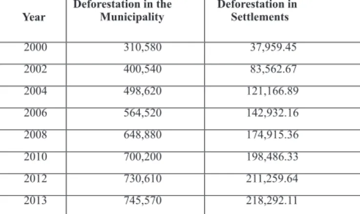
In 2000, deforestation in areas intended for the implementation of settlement projects was estimated at 37,959.4 hectares, which represented 10.08% of the total area of these projects in the municipality. In addition, it is important to highlight that up to the year 2008, deforestation in polygons smaller than 50 hectares had already been detected in more than half of the areas of the municipality of Novo Repartimento, associating the presence of small producers with changes in land use (IPAM, 2009). The accumulated total deforestation for the year 2013 was 218,292.11 hectares, representing 57.94% of the area of the settlements, as can be observed in figure 3, which highlights the evolution of deforestation in settlements in the period 2000 to 2013.
Table 5 - Evolution of Deforestation in Settlements (2000-2013) - Accumulated Areas (Ha)
Year
Deforestation in the Municipality
Deforestation in Settlements
2000 310,580 37,959.45
2002 400,540 83,562.67
2004 498,620 121,166.89
2006 564,520 142,932.16
2008 648,880 174,915.36
2010 700,200 198,486.33
2012 730,610 211,259.64
2013 745,570 218,292.11
Source: PRODES, 2013.
.ufc.br
question by Prodes, an evolution has been detected in the deforested areas included in settlement projects, from the increase of 180,332.66 hectares of deforested areas, reflecting the need for intense and effective measures to combat and prevent deforestation in these areas.
Table 6 shows that the higher increases in deforestation rates observed for the settlements in the municipality reflect the increase in the implementation of new projects, coinciding with its main years of creation (2001 and 2003). This finding is in line with the statements of Castro & Watrin (2013), showing that the implementation of settlement projects in the Amazon is an activity that generates large environmental impacts when it is not accompanied by adequate planning.
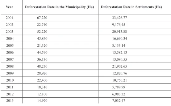
Table 6 - Comparison of Deforestation Rates in Novo Repartimento
Year Deforestation Rate in the Municipality (Ha) Deforestation Rate in Settlements (Ha)
2001 67,220 33,426.77
2002 22,740 9,176,45
2003 52,220 20,913.88
2004 45,860 16,690.34
2005 21,320 8,133.14
2006 44,590 13,582.13
2007 36,130 13,080.55
2008 48,230 21,902.65
2009 28,920 12,820.76
2010 22,400 10,750.21
2011 18,310 5,789.99
2012 12.100 6,983.32
2013 14,970 7,032.47
Source: PRODES, 2013.
No new settlement projects were created after 2005. However, the year 2008 is noteworthy, similarly to what happened in the Amazon, there was a sudden increase in deforestation, reflected in the state of Pará and in the municipality of Novo Repartimento, pointed out by Arraes et al. (2012), due to the increase in the price of commodities such as meat and soy. It is inferred, therefore, that the same vectors of deforestation present on the other scales - regional, state and municipal - may have acted in the settlement areas.
In spite of the falling trend of increases in deforestation, it is important to note the important implications that existing deforested areas have for environmental changes, depending on the lan -dscape context (BRONDÍZIO et al., 2009). The investigation of these implications to characterize and evaluate the impacts in areas of the Amazon is addressed by Fearnside (2005) and Abranches (2014).
RESULTS AND DISCUSSION
According to data obtained and summarized in Table 3, there was a significant increase in deforestation in the municipality of Novo Repartimento, which rose from 310,580 hectares in 2000 to 745,570 hectares in 2013, representing an increase of 141.67% in deforested areas in 13 years. Overall, this rate represents an average annual loss of 33,845 hectares of forest in this period.
www
.mercator
of the municipality) of forest cover had been deforested by 2013. This amount corresponds to ap -proximately 50% of the total deforested area in the municipality during the same period, that is, 439,990 hectares.
The settlements that presented the greatest losses of forest areas were: P.A. Nossa Senhora da Guia, with a deforestation rate of 83% in relation to the total area of the settlement; P.A. Manuelito, with a deforestation rate of 81% in relation to the total area of the settlement; and P.A. José Martins Pessoa, with a deforestation rate of 80% in relation to the total settlement area. In 2013, of the 31 settlements detected, only P.A. Carajás and P.A. Iolanda had deforestation rates below 50% of their total area; 45% and 32%, respectively.
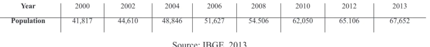
It is noted that the higher the density of families in the settlements, the greater the proportion of deforested area. The search for areas in this region has already been exposed by Homma et al. (2001), who affirmed that the Southeast of Para is the destination of migrants from other regions of the country. Such a claim can be substantiated by the population growth of the municipality related to the period under study, as presented in table 7.
Table 7 - Population Growth in the Municipality of Novo Repartimento
Year 2000 2002 2004 2006 2008 2010 2012 2013
Population 41,817 44,610 48,846 51,627 54.506 62,050 65.106 67,652
Source: IBGE, 2013.
Calandino et al. (2012) stress that the settlement policy selects families of great socio-economic fragility, but since the same settlement policy is inefficient in creating socioeconomic conditions conducive to establishing the families, they end up supporting themselves with solutions of rapid financial return, such as logging or the sale of lots. In other words, they clear the forest precisely because they fulfil the characteristics required of Agrarian Reform beneficiaries, expressed in their socioeconomic vulnerability.
Another possible cause for the advance of deforestation in settlement areas is the expansion of cattle ranching. With the increase in the implementation of the CAR (Rural Environmental Regis-ter) in the municipality, whose coverage before 2008 was 14,535.46 hectares (2 properties) and, in 2003, had already reached a total of 199,345.58 hectares (1,604 properties), the demand for credit programs subsidizing investments in the new activities also increased. They were considered more profitable, justifying the increase of the municipality’s livestock herd. Far more significant than population growth, in 2012 the expansion of the herd in the municipality of Novo Repartimento represented a six-fold increase in the number of cattle relative to the year 2000, as shown in table 8.
Table 8 - Expansion of the Cattle Herd in the Municipality of Novo Repartimento
Year 2000 2002 2004 2006 2008 2010 2012
Numbr of Heads of Cattle
130,540 148,989 454,051 460,650 381,628 631,504 791,795
Source: SAGRI, 2012.
The New Forest Code has brought with it the intention of promoting promote actions to combat deforestation and forest fires, the adoption of more sustainable practices and changes in environmental policy. However, there was an increase in deforestation rates in settlement projects, associated to the change in the reference of the quota of rivers to establish Permanent Protection Areas (APPs) and the forest recomposition rule, which reduces the requirements for small properties.
.ufc.br
the difficulty of access to many settlements and their extensive area, it is increasingly difficult to promote actions to control and supervise settlement projects efficiently.
Defined as an agricultural development policy, land credit provides an opportunity for financing settlements for land acquisition and the structuring of new productive units with the implementation of infrastructure. Created to be a policy promoting sustainable development and environmental conservation, it has been associated with increased deforestation, since it increases the demand for land ownership and enhances agricultural activities.
In order to change this scenario and to develop sustainable productive activities and the en-vironmental recovery of already degraded areas in the settlements, INCRA prepared the Program for Prevention, Combat and Alternatives to Illegal Deforestation in Settlements of the Amazon (Settlements in the Amazon), created through INCRA Ordinance No. 716, of November 27, 2012, in partnership with the Ministry of Agrarian Development (MDA).
However, the municipality of Novo Repartimento is still a target for environmental monito -ring and enforcement efforts, being considered as a “Priority Municipality” by the Ministry of the Environment. To leave the list, a municipality must meet three criteria: reduce deforestation to less than 40 km2 per year; implement the Rural Environmental Register (CAR) in 80% of its territory, excluding indigenous lands and protected areas; and have deforestation less than or equal to 60% of the average deforestation of the previous two years (FUNDO VALE, 2012).
To achieve these goals, municipal management will need to develop activities with an emphasis on settlement projects, since they have been responsible for approximately 50% of deforestation in recent years (2000 to 2013), thus contributing to socio-environmental improvements and streng-thening initiatives to develop sustainable activities.
FINAL CONSIDERATIONS
The results found are important to show the influence that Agrarian Reform settlements have on the total deforestation in the municipality, as evidenced by an increase of 141.67% in deforested areas in 13 years. Besides agriculture, among the main agents of deforestation is the expansion of cattle farming, which is the cause of the conversion of forest areas to extensive pasture regions.
In conclusion, it should be noted that 218,292 hectares (14% of the area of the municipality) of forest cover were deforested in the period from 2000 to 2013, corresponding to approximately 50% of the total deforested area in the municipality during the same period; 439,990 hectares. These results confirm the hypothesis that the settlement projects have a great potential to generate deforestation and forest degradation in the municipality of Novo Repartimento. In addition, the challenge of managing settlement projects is to ensure access to land for smallholders, thereby secu -ring their source of income from appropriate productive initiatives, as well as conserving available forest resources. To this end, it is important to strengthen public policies appropriate to the reality in the settlements, taking into account the concrete needs and particularities of the settlers, such as the improvement of the infrastructure of the projects and the feasibility of access to information regarding the markets for forest and agricultural products.
BIBLIOGRAPHIC REFERENCE
ABRANCHES, S. The Political Economy of Deforestation in Brazil and Payment- for-Performance
Finance. Londres: Center for Global Development, 2014, 52 p.
ACSELRAD, H.; SILVA, M. G. Rearticulações sociais da terra e do trabalho em áreas de grandes projetos
hidrelétricos na Amazônia. In: ZHOURI, A. (Org.). As Tensões do Lugar. Belo Horizonte: Ed. UFMG. 2011.
-www
.mercator
mento no contexto mundial. Revista de Economia e Sociologia Rural, v. 50, n. 1, p. 119-140, 2012.
AZEVEDO, A. A.; RAJÃO, R.; COSTA, M.; STABILE, M. C. C.; ALENCAR, A.; MOUTINHO, P.
Ca-dastro Ambiental Rural e sua influência na dinâmica do desmatamento na Amazônia Legal. Brasília: IPAM, 2014, 16 p.
BARLOW, J.; EWERS, L.; ANDERSON, L.; ARAGAO, L. E. O.; BAKER, T. R.; BOYD, E.; FELDPAUSCH, T. R.; GLOOR, E.; HALL, A.; MALHI, Y.; MILLIKEN, W.; MULLIGAN, M.; PARRY, L.; PENNINGTON, T.; PERES, C. A.; PHILLIPS, O. L.; ROMAN-CUESTA, R. M.; TOBIAS, J. A.; GARDNER, T.A. Using learning networks to understand complex systems: a case study of biological, geophysical and social research
in the Amazon. Biological Reviews, V. 86, 2011.
BATISTELLA, M.; BRONDIZIO, E. Uma estratégia integrada de análise e monitoramento de assentamentos
rurais na Amazônia. GIS BRASIL 2001, 7, Curitiba. Anais, FatorGis-Selper, 2001.
BECKER, B. K. Amazônia. Parcerias Estratégicas, v. 18, n. 36, p. 107-128, 2013.
BÖRNER, J.; MARINHO, E.; WUNDER, S. Mixing Carrots and Stickstoff Conserve Forests in the Brazilian
Amazon: A Spatial Probabilistic Modeling Approach. PloS one, v. 10, n. 2, 2015.
BOUCHER, D.; ROQUEMORE, S.; FITZHUGH, E. Brazil’s success in reducing deforestation. Tropical
Conservation Science, v. 6, n. 3, p. 426-445, 2013.
BRANDÃO JÚNIOR, A.; SOUZA JÚNIOR, C. Desmatamento nos assentamentos de Reforma Agrária na Amazônia. O Estado da Amazônia, v. 7, n. 4, 2006.
BRASIL, L. S.; BATISTA, J. D.; GIEHL, N. F. D. S.; VALADÃO, M. B. X.; SANTOS, J. O. D.; DIAS
--SILVA, K. Environmental integrity and damselfly species composition in Amazonian streams at the” arc of
deforestation” region, Mato Grosso, Brazil. Acta Limnologica Brasiliensia, v. 26, n. 3, p. 278-287, 2014.
BRONDIZIO, E. S.; CAK, A.; CALDAS, M.M.; MENA, C.; BILSBORROW, R.; FUTEMMA, C.; LUDEWI
-GS, T.; MORAN, E. F.; BATISTELLA, M. Small Farmers and Deforestation in Amazonia. In: American
Geophysical Union (Org.). Amazonia and Global Change, Vol. 186. Am. Geoph. Union, 2009, p. 117-143.
CABRAL, C. D. S. R.; GURGEL, A. C. Análise Econômica da Limitação do Desmatamento no Brasil
Utilizando um Modelo de Equilíbrio Geral Computável. Anais do XLI Encontro Nacional de Economia.
ANPEC-Associação Nacional dos Centros de Pós-Graduação em Economia, 2014.
CALANDINO, D.; WEHRMANN, M.; KOBLITZ, R. Contribuição dos assentamentos rurais no desma
-tamento da Amazônia: um olhar sobre o Estado do Pará. Desenvolvimento e Meio ambiente,
v. 26, 2012.
CASTRO, A. R.; WATRIN, O. Análise espacial de áreas com restrição legal de uso do solo em projeto de assentamento no sudeste paraense. Geografia Ensino & Pesquisa, v. 17, n. 2, p. 157-166, 2013.
COY, M.; KLINGLER, M. Frentes pioneiras em transformação. Territórios e Fronteiras, v. 7, n. 1, 2014.
CROMBERG, M.; DUCHELLE, A. E.; ROCHA, I. D. O. Local Participation in REDD+. Forests, v. 5, n.
4, p. 579-598, 2014.
CURADO, F. F. A descentralização da Reforma Agrária: algumas notas sobre o cenário brasileiro. Revista
do Serviço Público, v. 53, n. 1, p. 135-157, 2014.
DINIZ, F. H.; HOOGSTRA-KLEIN, M. A.; KOK, K.; ARTS, B. Livelihood strategies in settlement projects
in the Brazilian Amazon. Journal of Rural Studies, v. 32, 2013.
DUCHELLE, A. E.; CROMBERG, M.; GEBARA, M. F.; GUERRA, R.; MELO, T.; LARSON, A.; CRONK
-LETON, P.; BÖRNER, J.; SILLS, E.; WUNDER, S.; BAUCH,S.; MAY, P.; SELAYA, A.; SUNDERLIN,
W. D. Linking forest tenure reform, environmental compliance, and incentives. World Development, v.
55, p. 53-67, 2014.
EZZINE-DE-BLAS, D.; BÖRNER, J.; VIOLATO-ESPADA, A. L.; NASCIMENTO, N.; PIKETTY, M. G. Forest loss and management in land reform settlements. Environmental Science & Policy, v. 14, n. 2, 2011.
FATORELLI, L.; MERTENS, F. Integração de políticas e governança ambiental. Ambiente & Sociedade,
v. 13, n. 2, p. 401-415, 2010.
FEARNSIDE, P. M. Desmatamento na Amazônia. Acta amazônica, v. 36, n. 3, p. 395-400, 2005.
.ufc.br
de Economia e Sociologia Rural, v. 53, n. 1, p. 91-108, 2015.
FUNDO VALE PARA O DESENVOLVIMENTO SUSTENTÁVEL. Municípios Verdes. Rio de Janeiro:
FUNDO VALE, 2012, 106 p.
GALFORD, G. L.; SOARES-FILHO, B. S.; CERRI, C. E. P. Prospects for land-use sustainability on the
agricultural frontier of the Brazilian Amazon. Philosophical Transactions of the Royal Society B: Biological
Sciences, v. 368, n. 1619, 2013.
GOMEZ, M. V.; BEUCHLEA, R.; SHIMABUKUROA, Y.; GRECCHI, R.; SIMONETTI, D.; EVA, H. D.; ACHARD, F. A long-term perspective on deforestation rates in the Brazilian Amazon. International Archives of the Photogrammetry, Remote Sensing & Spatial Information Sciences, 2015.
HEREDIA, B.; MEDEIROS, L. S.; PALMEIRA, M.; CINTRÃO, R.; LEITE, S. P. Análise dos impactos
regionais da Reforma Agrária no Brasil. Estudos Sociedade e Agricultura, v. 1, 2013.
HOMMA, A. K. O.; CARVALHO, R. A.; SAMPAIO, S. M. N.; SILVA, B. N. R.; SILVA, L. G. T.; OLIVEI
-RA, M. C. C. A instabilidade dos projetos de assentamentos como indutora de desmatamentos no sudeste
araense. Anais do Encontro Nacional da Sociedade Brasileira de Economia Ecológica, 4ª edição. Belém,
Pará: ECOECO, 2001.
INSTITUTO DE DESENVOLVIMENTO ECONÔMICO, SOCIAL E AMBIENTAL DO PARÁ (IDESP).
Relatório Técnico. Belém: IDESP, 2012, 4 p.
INSTITUTO DE DESENVOLVIMENTO ECONÔMICO, SOCIAL E AMBIENTAL DO PARÁ (IDESP).
O Estado do Pará no Contexto do Desmatamento 2013. Belém: IDESP, 2013, 19 p.
INSTITUTO DE PESQUISA AMBIENTAL DA AMAZÔNIA. Indicadores Socioeconômicos e espaciais
dos municípios prioritários para o controle do desmatamento no Estado do Pará. Belém: IPAM, 2009,
155 p.
INSTITUTO DO HOMEM E MEIO AMBIENTE DA AMAZÔNIA (IMAZON). Desmatamento e
degra-dação florestal em Novo Repartimento- Pará. Belém: IMAZON, 2014, 2 p.
LE TOURNEAU, F. M.; BURSZTYN, M. Assentamentos rurais na Amazônia: contradições entre a política agrária e a política ambiental. Ambiente & Sociedade, v. 13, n. 1, 2010.
LIMA, P. V. P. S.; KHAN, A. S.; CASIMIRO FILHO, F.; VIANA, J. J. POLÍTICAS PÚBLICAS E DE
-SENVOLVIMENTO SUSTENTÁVEL. Revista de Políticas Públicas, v. 15, 2011.
MACEDO, M. R. A.; DARNET, L. A. F.; THALÊS, M. C.; POCCARD-CHAPUIS, R. Configuração espacial
do desmatamento em fronteira agrícola na Amazônia. REVISTA NERA, n. 22, 2013.
MARTINS J.; BICUDO M. A. A pesquisa qualitativa em psicologia. São Paulo: Ed. Centauro, 2005, 110 p.
MINISTÉRIO DO MEIO AMBIENTE (MMA). Plano de Ação para Prevenção e Controle do
Desmata-mento da Amazônia Legal. Brasília: MMA, 2009, 50 p.
MINISTÉRIO DO MEIO AMBIENTE (MMA). Plano de Ação para prevenção e controle do
desmata-mento na Amazônia Legal (PPCDAm). Brasília: MMA, 2013, 174 p.
NOGUEIRA, E. M.; YANAI, A. M.; FONSECA, F. O.; FEARNSIDE, P. M. Carbon stock loss from de
-forestation through 2013 in Brazilian Amazonia. Global change biology, v. 21, n. 3, p. 1271-1292, 2015.
PACHECO, P. Agrarian Reform in the Brazilian Amazon. World Development, v. 37, n. 08, 2009.
PIKETTY, M. G.; POCCARD-CHAPUIS, R.; DRIGO, I.; COUDEL, E.; PLASSIN, S.; LAURENT, F.; THÂ
-LES, M. Multi-level Governance of Land Use Changes in the Brazilian Amazon. Forests, v. 6, n. 5, 2015.
RETTMANN, R. Redução do desmatamento na Amazônia por meio da intensificação da pecuária em
assentamentos de reforma agrária. Brasília. Dissertação de Mestrado. Universidade de Brasília. 2013.
REYDON, B. P.; FERNANDES, V. B.; TELLES, T. S. Land tenure in Brazil. Land Use Policy, v. 42, p.
509-516, 2015.
ROSA, I. M.; PURVES, D.; SOUZA JÚNIOR, C.; EWERS, R. M. Predictive modelling of contagious de
-forestation in the Brazilian Amazon. PloS one, v. 8, n. 10, 2013.
SANTOS, I. V.; PORRO, N. M.; PORRO, R. A Intervenção no Desmatamento e a Estabilidade na
Pro-priedade da Terra. Belém: International Land Coalition America Latina, 2010, 52 p.
-www
.mercator
DO, J. C. D. M. A transformação do espaço amazônico e seus reflexos na condição atual da cobertura e uso
da terra. Novos Cadernos NAEA, v. 16, n. 1, 2013.
SILVA, L. G. A Expansão da Pecuária na Amazônia. Revista de Estudos Sociais, v. 15, n. 29, p. 79-96, 2014.
SIST, P.; SABLAYROLLES, P.; BARTHELON, S.; SOUSA-OTA, L.; KIBLER, J. F.; RUSCHEL, A.; SANTOS-MELO, M.; EZZINE-DE-BLAS, D. The Contribution of Multiple Use Forest Management to
Small Farmers’ Annual Incomes in the Eastern Amazon. Forests, v. 05, n. 07, 2014.
SOARES-FILHO, B. S.; NEPSTAD, D. C.; CURRAN, L.; CERQUEIRA, G. C.; GARCIA, R. A.; RAMOS, C. A.; VOLL, L.; MCDONALD, A.; LEFEBVRE, P.; SCHLESINGER, P.; MCGRATH, D. Cenários de
desmatamento para a Amazônia. Estudos Avançados, v. 19, n. 54, 2005.
SOARES, J. L. N. A organização territorial de assentamentos rurais para atender a legislação ambiental na
Amazônia. Campo-Território: revista de geografia agrária (Uberlândia), v. 3, n. 6, p. 143-155, 2008.
SOUZA, E. S.; RAMOS, D. P.; HEINECK, D. T.; GOMES, R. M. Impacto das estruturas urbanas em relação à biodiversidade Amazônica. Revista de Arquitetura IMED, v. 3, n. 2, 2015.
VALE, P. M. The Conservation versus Production Trade-off. Londres: The London School of Economics and Political Science, 2015, 37 p.
VASCONCELOS, C. H.; NOVO, E. M. L. M. Mapeamento do uso e cobertura da terra a partir da segmen
-tação e classificação de imagens fração solo, sombra e vege-tação derivadas do modelo linear de mistura aplicado a dados do sensor TM/Landsat5, na região do reservatório de Tucuruí PA. Acta Amazônica, v. 34, n. 3, p. 487-493, 2004.
VERÍSSIMO, A.; PEREIRA, D. Produção na Amazônia Florestal: características, desafios e oportunidades.
Parcerias Estratégicas, v. 19, n. 38, p. 13-44, 2014.
YANAI, A. M.; NOGUEIRA, E. M.; FEARNSIDE, P. M.; GRAÇA, P. M. L. A. Desmatamento e perda
de carbono até 2013 em assentamentos rurais na Amazônia Legal. Anais do XVIII Simpósio Brasileiro de