Anais da Academia Brasileira de Ciências (2014) 86(4): (Annals of the Brazilian Academy of Sciences)
Printed version ISSN 0001-3765 / Online version ISSN 1678-2690 www.scielo.br/aabc
1573-1595
http://dx.doi.org/10.1590/0001-3765201420130274
The sea-level highstand correlated to marine isotope stage (MIS) 7 in the coastal plain of the state of Rio Grande do Sul, Brazil
RENATO P. LOPES1, SERGIO R. DILLENBURG1, CESAR L. SCHULTZ1, JORGE FERIGOLO1,2, ANA MARIA RIBEIRO1,2, JAMIL C. PEREIRA1,3, ELIZETE C. HOLANDA4, VANESSA G. PITANA1 and LEONARDO KERBER1
1Programa de Pós-Graduação em Geociências, Universidade Federal do Rio Grande do Sul/UFRGS, Av. Bento Gonçalves, 9500, Agronomia, 91540-000 Porto Alegre, RS, Brasil
2
Fundação Zoobotânica do Rio Grande do Sul, Museu de Ciências Naturais, Seção de Paleontologia, Av. Salvador França, 1427, Jardim Botânico, 90690-000 Porto Alegre, RS, Brasil
3Museu Coronel Tancredo Fernandes de Mello, Rua Barão do Rio Branco, 467, 96230-000 Santa Vitória do Palmar, RS, Brasil
4Universidade Federal de Roraima, Instituto de Geociências, Departamento de Geologia, Av. Cap. Ene Garcez, 2413, Sala 11, Aeroporto, 69304-000 Boa Vista, RR, Brasil
Manuscript received on August 8, 2013; accepted for publication on February 17, 2014
ABSTRACT
The coastal plain of the state of Rio Grande do Sul, in southern Brazil, includes four barrier-lagoon depositional systems formed by successive Quaternary sea-level highstands that were correlated to marine isotope stages (MIS) 11, 9, 5 and 1, despite the scarcity of absolute ages. This study describes a sea-level highstand older than MIS 5, based on the stratigraphy, ages and fossils of the shallow marine facies found in coastal barrier (Barrier II). This facies outcrops along the banks of Chuí Creek, it is composed of fine, well-sorted quartz sand and contains ichnofossils Ophiomorphanodosa and Rosselia sp., and molluscan shells. The sedimentary record indicates coastal aggradation followed by sea-level fall and progradation of the coastline. Thermoluminescence (TL) and electron spin resonance (ESR) ages from sediments and fossil shells point to an age of ~220 ka for the end of this marine transgression, thus correlating it to MIS 7 (substage 7e). Altimetric data point to a maximum amplitude of about 10 meters above present-day mean sea-level, but tectonic processes may be involved. Paleoceanographic conditions at the time of the highstand and correlations with other deposits in the Brazilian coasts are also discussed.
Key words: Barrier II, Chuí Creek, MIS 7, Pleistocene, Paleoceanography.
Correspondence to: Renato Pereira Lopes E-mail: paleonto_furg@yahoo.com.br
INTRODUCTION
The Quaternary System encompasses the last 2.588 million years of Earth’s history, and has been characterized by glacial-interglacial cycles represented by the waxing and waning of ice
the oscillations of sea-level (eustasy). Although regional isostasy, faulting and uplifting in coastal areas also play an important role in relative sea-level changes, the oscillations are directly linked to variations in the volume of the ice sheets, thus variations in the ratio of oxygen isotopes (16O/18O) in microfossils and gases recovered from deep-sea and ice cores are used as proxies for changes in sea-levels, by assuming a relationship between these ratios and the ice volumes.
Despite being recognized in coastal areas all around the globe since the XIX century (e.g. Darwin 1846), direct, reliable and well-preserved indicators of past sea level highstands older than the Pleistocene marine transgression of ~125 ka BP correlated to marine isotope stage (MIS) 5, are relatively scarce throughout the globe. While oxygen isotope curves obtained from benthic foraminifera are used as indirect evidence of sea level oscillations through correlation with past ice volumes (Imbrie et al. 1984, Pisias et al. 1984, Martinson et al. 1987, Berger 2008), direct records in coastal areas are represented by paleo-shorelines that contain datable geomorphological features such as raised terraces, wave-cut notches and aeolianites(Pirazzoli et al. 1991, Hearty and Kindler 1995, Barreto et al. 2002) as well as other materials such as corals, vermetids or speleothems (Gallup et al. 1994, Angulo et al. 1999, 2006).
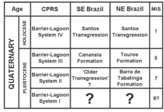
In the Brazilian coast, the Holocene highstand of ~6-5 ka BP (MIS 1) is well-represented by several deposits, despite of some discrepancies regarding their timing and amplitude (Martin et al. 2003, Angulo et al. 2006). Good records of the transgression correlated to MIS 5 are found in some areas (Poupeau et al. 1988, Suguio et al. 2003, 2011, Tomazelli and Dillenburg 2007) but the situation is complex for older transgressive events; so far, only the northeastern Brazilian coast has provided features recognized as having been formed by the marine transgression during MIS 7 (Barreto et al. 2002, Suguio et al. 2011). In the Coastal Plain of the
state Rio Grande do Sul (CPRS), in southern Brazil, records of sea level oscillations prior to MIS 5 were reported from microfossils in drilling cores (Closs 1970, Carreño et al. 1999) and geomorphological features (Poupeau et al. 1988, Villwock and Tomazelli 1995, Tomazelli et al. 2000).
The absolute chronologies and amplitudes of past sea-level oscillations in the coast of Rio
Grande do Sul, however, are not well defined yet.
This problem arises from the fact that most of the geomorphological units formed by sea-level highstands represent the aeolian facies of coastal barriers; these deposits are usually reworked by
erosion, aeolian deflation and/or vegetation growth.
In addition, the CPRS is composed essentially of siliciclastic sediments, devoid of consolidated structures that could contain paleo sea-level indicators such as vermetids or erosion notches, therefore the most reliable sea-level indicators would be found in well-preserved deposits representing the shallow marine facies of the barrier systems. These facies, however, are mostly covered by younger sediments and coastal lakes; so far, the ~125 ka-old Barrier System III is the only Pleistocene unit whose marine facies is well-preserved and exposed (Tomazelli and Dillenburg 2007).
This study presents a description of the shallow marine facies of the Barrier System II, from outcrops found in the southern sector of the CPRS, with information regarding the amplitude and chronology of the marine highstand that was responsible for the origin of this depositional system. Correlations with other deposits and paleoclimatic inferences from fossils and sedimentary features are also presented.
GEOLOGICAL SETTING
1575 SEA-LEVEL HIGHSTAND DURING MIS7 IN SOUTHERN BRAZIL
uppermost portion of the Pelotas Basin, the southernmost marginal basin of the Brazilian coast. This basin is composed of terrigenous siliciclastic sediments eroded from older geological units located landwards, accumulated in the coastal area since the split between South America and Africa in the Late Cretaceous; its maximum thickness is of approximately 10,000 meters (Closs 1970, Bueno et al. 2007, Barboza et al. 2008). During the Quaternary, sea-level oscillations correlated to glacial cycles reworked the uppermost sediments of the Pelotas Basin, as evidenced by facies changes and microfossil assemblages recovered from drilling holes (Closs 1970, Carreño et al. 1999).
The first systematic geological survey of the
CPRS was presented by Delaney (1965), who followed the classical lithostratigraphy and proposed the name “Itapoã Formation” for the aeolian deposits found along the coastal plain, while the marine deposits were named “Chuí Formation”; these units were considered of Quaternary age because they overlay the Tertiary “Graxaim Formation”. During the 1980s, new geological surveys led to a revision of the geology of the CPRS, and it became clear that the units grouped together as “Itapoã” and “Chuí” formations were in fact several distinct units deposited during different time intervals in response to distinct marine transgressions.
The new surveys led to the replacement of the classic lithostratigraphic scheme of Delaney (1965) by the concept of depositional systems formed by chronocorrelated facies and facies associations (Tomazelli and Villwock 2005). Following this scheme, the CPRS consit of an Alluvial Fans System (the former “Graxaim Formation”) of Miocene-Pliocene age (Closs 1970) and four barrier-lagoon depositional systems, each one correlated to a sea level highstand during a Quaternary interglacial period (Villwock and Tomazelli 1995). The Pleistocene marine highstands are recognized mostly by the aeolian facies of the barrier systems; deposits that represent the marine facies of these systems
are usually covered by younger sediments. Precise indicators of paleo sea-level highstands are scarce in these coastal barriers; the only reliable records of Pleistocene sea levels known so far are ichnofossils Ophiomorpha nodosa preserved some 5 to 7 meters a.s.l. in shallow marine facies of the Barrier System III (Tomazelli and Dillenburg 2007).
The southernmost portion of CPRS is dominated by two Pleistocene (II and III) and one Holocene (IV) barrier-lagoon systems. Each system was chronologically correlated by Villwock and
Tomazelli (1995) to the calibrated δ18O curves of Imbrie et al. (1984), therefore attributing ages of ~450 ka (MIS 11) for system I, ~325 ka (MIS 9) for system II, ~125 ka (MIS 5) for system III and ~6 ka (MIS 1) for system IV. TL datings on sandstones exposed on the shoreline beneath the Holocene sediments of the Barrier IV System provided age of 109 ± 7.5 ka BP, reinforcing the proposed age for Barrier System III (Buchmann and Tomazelli 2003).
BARRIER SYSTEM II
This system is well-represented along the southern sector of the CPRS, stretching almost continuously for more than 200 km in the same SW-NE orientation of the coastline. The only important interruption is in the area of Taim, where a negative gravimetric anomaly suggests the existence of deformation features in the underlying bedrock, formed during the opening of the South Atlantic (Rosa et al. 2007). Only a small portion of this barrier is preserved in the northern area of the CPRS (Poupeau et al. 1988, Villwock and Tomazelli 1995).
The aeolian deposits of this system reach up to 25 meters above present sea-level and are composed
of siliciclastic, well-sorted fine to medium quartz
1577 SEA-LEVEL HIGHSTAND DURING MIS7 IN SOUTHERN BRAZIL
The low topographic area located landwards of the barrier is occupied by a large water body (Mirim Lake). The barrier gently dips seawards, where it is covered by younger sediments of the Barrier-Lagoon System III. The only area known so far where the shallow marine facies of the barrier outcrops is along the Chuí Creek, near the town of Santa Vitória do Palmar (Figure 2a). This
fluvial system flows in a NE-SW direction until
the town of Chuí, where it turns SE following the Chuí faulting zone. The creek was a shallow water course that was further deepened in the early 1960s to drain the surrounding wetlands and provide area for agriculture.
STRATIGRAPHY OF THE SHALLOW MARINE FACIES
The deepening of the creek exposed at the base of the banks a layer of marine sediments; these are beneath a terrestrial sequence formed by paleosoils,
fluviolacustrine facies that contain remains of
Pleistocene mammals (Figure 2b, c) and silty loam
of loessic orgin (Lopes et al. 2009, 2011). The first
stratigraphic description of the deposits exposed along Chuí Creek was presented by Soliani (1973), who correlated the marine sediments to the “Chuí Formation” of Delaney (1965) and assigned the overlying fossil-bearing strata to a new unit which he called “Santa Vitória Formation”.
Under the new concept adopted since the 1980s, these marine sediments are recognized as the marine facies of Barrier II. These sediments constitute the uppermost portion of the highstand systems tract of the Barrier System II (HST2) according to the stratigraphic scheme proposed by Rosa (2012), while the overlying sediments are part of the Lagoon System III.
This facies is composed of fine, well-sorted
siliciclastic sand with some amounts of biogenic carbonate, heavy minerals, muscovite and some minerals of terrigenous origin. Primary sedimentary structures are well-represented by cross and
parallel stratifications (Figure 3b, c). The presence
of erosion surfaces, ichnofossils and densely-packed shell concentrations (see below) suggests the occurrence of storm events. The sedimentary structures and ichnofossil content indicate that this facies was deposited under similar conditions (upper shoreface-foreshore) of the Facies B described from the Barrier System III (Tomazelli and Dillenburg 2007).
The ~2 meter-thick marine layer exposed along the banks of the creek clearly indicates a sea-level rise, but from the base to the top portion of the layer there are no visible faciological changes. In a shallow slope coast such as the one of Rio Grande do Sul (between 0.03° and 0.08°; Dillenburg et al. 2009), a sea-level rise would result in increased depth and lateral migration of facies,
therefore the lower shoreface (finer) sediments
would be deposited on top of upper shoreface
(coarser) sediments. The absence of fine sediments
in the marine facies and the persistence of shallow marine conditions throughout the exposed portion of the sequence, however, show that there were no faciological changes despite of sea-level rise. This suggests that sea-level rise was accompanied by high sedimentation rates, which resulted in aggradation of the coastline, followed by sea-level fall and progradation.
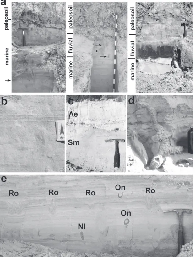
The presence of terrestrial deposits on top of the shallow marine sediments indicates that this system evolved as a progradational (regressive) barrier, also indicated by GPR data (Rosa 2012). At least three types of contact between the marine facies and the overlying terrestrial sediments have
been identified (Figure 3). One is characterized
by paleosoils developed directly on top of the
shallow marine facies, with root traces, mud-filled
root cavities and usually mottled by iron oxide (Figure 3a), and sometimes aeolian deposits are also found on top of the marine sediments (see
Figure 3c). Another type of contact is
Figure 2 - a) Satellite image of the southernmost CPRS showing the location of Chuí Creek and the Pleistocene depositional systems (‘L’ = Lagoon Systems, ‘B’ = Barrier Systems; b) Schematic configuration of the Pleistocene depositional systems in the southern CPRS
1579 SEA-LEVEL HIGHSTAND DURING MIS7 IN SOUTHERN BRAZIL
Figure 3 - a) Aspects of the marine-terrestrial transition: paleosoils (left), fluvial concordant (Type 1, in the middle; the arrows
indicate mud intraclasts, each division of the scale = 10 cm) and fluvial erosive (Type 2, on the right); b) Detail of the parallel- and cross-stratifications; c) Shallow marine sediments (Sm) truncated by aeolian sediments (Ae) on the upper part of the marine facies;
d) Ichnofossil Ophiomorphanodosa; e) Association of Rosselia sp. (Ro), O. nodosa (On) and unidentified (NI) ichnofossils.
and mammalian remains; the absence of erosive surfaces indicates a gradual transition from marine to
fluvial environments. This type of fluvial system was
probably established when regional base level was still high, before sea-level had fully retreated after the
marine highstand. The third type of contact is fluvial
erosive (Type II, Figure 3c), visible along the banks as 30 to 40 cm-thick and up to 7 meters-long dark brown sand lenses. The lenses contain vertebrate fossils and mud intraclasts, and are interpreted as
oxbow lakes (Lopes et al. 2009). At least five of these
lenses have been observed so far along the banks, and the contact with the underlying marine sediments is
erosive, indicating that this type of fluvial system
was formed at a time when the regional base level was lowered, i.e., when sea-level had fully retreated. One dating by thermoluminescence (see below) reinforces this interpretation.
FOSSIL CONTENT
Until recently, only ichnofossils had been found in the marine facies (Lopes et al. 2001). The most conspicuous ichnofossil is Ophiomorpha nodosa, consisting of pellet-lined vertical shafts and horizontal galleries (Figure 3d), produced by thalassinidean crustaceans. This ichnofossil is regarded as an indicator of shallow marine conditions (Frey et al. 1978, Pollard et al. 1993), and is also common in the marine facies of the Barrier System III (de Gibert et al. 2006, Tomazelli and Dillenburg 2007).
Another type of ichnofossil is Rosselia sp. (Figure 3e), produced by terebellid polychaetes in shallow marine settings (Nara 2002). These traces are usually spindle-shaped vertical galleries, but the ones found in Chuí Creek are conical-shaped and usually nested within each other, which suggests that were truncated by storm events. Both Ophiomorpha and Rosselia are found from the lower to the upper level of the marine facies.
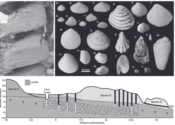
The only body fossils found so far in the marine facies consist of molluscan shells, ostracod carapaces
and foraminiferal tests, forming at least four densely-packed concentrations (Lopes and Simone 2012, Lopes et al. in press). These concentrations consist of marine, mostly shallow-living infaunal bivalves, and include complete, well-preserved specimens
and small, rounded and unidentifiable fragments.
Because the four concentrations outcrop at the same stratigraphic position, contain essentially the same taxa and exhibit the same pattern of preservation, it is assumed that they represent a single isochronous taphocoenosis (Lopes and Simone 2012).
The association between complete shells, including articulated bivalves and ostracodes, and smaller, much abraded fragments, seems to indicate that a storm event was responsible for the deposition of this assemblage. Vertical shafts of O. nodosa were observed crossing one of the shell concentrations (Lopes et al. 2013). The ostracods have not been described yet, but the foraminiferal assemblage is dominated by Ammonia beccari forma tepida, followed by Buccella peruviana and Elphidium discoidale, in addition to a few individuals of other genera; the composition of the
assemblage indicates the influence of warm coastal
waters (Lopes and Bonetti 2012).
1581 SEA-LEVEL HIGHSTAND DURING MIS7 IN SOUTHERN BRAZIL
creek, the shells occur as densely-packed, storm-generated accumulations, while the specimens from the drillholes, are mostly isolated and dispersed within the sandy matrix. Foraminifers Ammonia beccari and Elphidium discoidale were also found among sediments retrieved from the drillholes, but are very scarce.
The shells found in Chuí Creek are at 7.5 meters above present-day m.s.l., while in the drillholes shells were found at depths ranging from present-day sea level to up to ~5 meters above m.s.l (Figure 4). The sedimentary matrix containing the shells is
essentially the same in all drillholes (fine sand with
marine macro- and microfossils, about 10% of heavy minerals and biogenic carbonate), therefore it seems to indicate the seawards continuity of the marine facies of the Barrier II. Nevertheless, it is also possible that the shells found underneath Barrier III may represent a marine facies deposited by the transgression that formed this unit (see Figure 2b), because this barrier seems to have had a transgressive behavior in the southern CPRS (Rosa 2012, Lima et al. 2013). The stratigraphic data from the drillings are inconclusive, however, because
even though the techniques employed allows the
identification of facies changes, it does not enable
the visualization of the contacts between facies.
TIMING AND AMPLITUDE OF THE MARINE HIGHSTAND
The only absolute ages obtained so far for the Pleistocene deposits of the CPRS were from the Barrier System III (Poupeau et al. 1988, Buchmann and Tomazelli 2003). As an attempt to establish a more precise chronology for this marine highstand, fossil shells and mammalian remains were dated by electron spin resonance (ESR), and sediments extracted from the marine and overlying terrestrial beds exposed along the creek, were dated using thermoluminescence (TL).
The ESR ages for mammalian fossils from Chuí Creek provided ages of 226 ± 35, 42 ± 3, 38 ± 2 and 34 ± 7 thousand years (Lopes et al. 2010, in press). The ~226 ka-old sample was collected at the lowermost portion of the fossil-bearing layer, just above the marine sediments. Its age, being much older than previously estimated for the fossil assemblage (e.g. Lopes et al. 2009), raised the question of whether the marine facies below could represent a transgression younger than MIS 9 (about 325 ka BP), which was originally proposed by Villwock and Tomazelli (1995).
As an attempt to test this assumption and refine the regional chronostratigraphy, fifteen molluscan
shells, plus another six mammalian teeth from the
fluvial facies were also selected for dating using
ESR. The shell specimens were collected from three storm-generated concentrations exposed at the lower portion of the shallow marine facies. The results points to an age close to 235-238 ka for the shells (Lopes et al. in press), an estimate consistent with the the TL ages obtained from the overlying sediments. The mammalian teeth provided ages between 80±10 ka and 42±3 ka, also consistent with the previous ESR datings (Lopes et al. 2010).
In addition to ESR datings, four sediment samples were collected for age determination
using TL dating. One sample was collected from the shallow marine facies, about 1 meter below the marine-continental transition (Figure 5a), and another was extracted from fossil-bearing aeolian sediments located ~1 meter above, at the basis of the continental sequence (Figure 5b). The two other samples were also collected from the continental unit, but in different points along the banks. One was extracted from a fossiliferous dark sand lens
which represents one fluvial-erosive facies (Figure
5c), and the other was collected from paleosoils positioned about 0.5 m above the top of the marine facies (Figure 5d).
The TL ages were determined using the multiple aliquote regeneration (MAR) protocol. The sediments from the shallow marine facies provided an age of 235.5 ± 23.5 ka BP, and the sediments collected near the mammalian fossils provided an age of 214 ± 21 ka BP. The sample
from the fluvial facies was dated as of 173 ± 22 ka
BP, while the sample from the paleosoil provided an age of 132 ± 18 ka BP, respectively (Figure 5).
The altimetric data were obtained with Total Station, using as reference a nearby geodetic reference level (RN1968U, 33°36’03”S / 053°19’54”W), com-plemented by digital elevation models of the Shuttle Radar Topography Mission (SRTM). The results show that the contact between the marine and continental sequences observed along the creek (see Figure 2) is nearly 9.5 meters a.m.s.l. Subsurface features detected with ground-penetrating radar (GPR) surveys between Barrier Systems II and III show that the height of this contact vary between ~12 and 8.5 meters a.s.l. (Rosa 2012), therefore the estimated mean amplitude of this marine highstand is of ~10 ± 1 meters a.m.s.l.
DISCUSSION
AMPLITUDE OF THE TRANSGRESSION
1583 SEA-LEVEL HIGHSTAND DURING MIS7 IN SOUTHERN BRAZIL
of the Barrier System II described here is the first
paleo sea-level indicator older than MIS 5 with good stratigraphic control and associated datings found in the CPRS. The obtained data improve the Pleistocene-Holocene sea-level curve for southern Brazil (Figure 6). The estimated amplitude is about 6±1 m a.s.l for the MIS 5 highstand (Tomazelli and Dillenburg 2007), and 4±1 m for the Holocene highstand (Martin et al. 2003, Angulo et al. 2006, Caron 2007). Although Villwock and Tomazelli (1995) estimated amplitudes between 18 and 24 meters a.s.l for this transgression, based on terraces cut along the western margin of Mirim Lake and Patos Lagoon, the sedimentary record suggests a lower amplitude.
Figure 5 - Composite stratigraphic section of the banks (on the left) showing the results of TL and ESR datings; on the right, pictures of the poits where the sediment samples were collected (indicated by letters and black circles). The horizontal arrows point the marine-terrestrial transition; vertical black arrows indicate mammalian remains, and the white one indicates an ichnofossil
O. nodosa (divisions of the scale = 10 cm); the facies are shallow marine (a), aeolian (b), fluvial erosive (c) and paleosoil (d).
A comparison among paleo sea-level records found around the globe show that estimates of the amplitude of highstands during MIS 7 are highly variable (Table I), but are below the values found for the Barrier System II. While some data indicate that the sea level during that interval did not reach amplitudes comparable to present mean sea-level (Dutton et al. 2009, Bard et al. 2002, Schellmann and Radtke 2004), other records indicate sea levels equal or slightly above the present one (Bezerra et al. 1998, Vesica et al. 2000). This variability is likely to be caused by different dating methods employed (U/ Th series, ESR), by differences among dated materials (corals, vermetids, shells, sediments) and by the tectonic history of each site, as is the case for Holocene deposits in northeastern Brazil (Barreto et al. 2002, Suguio et al. 2011). Moreover, it shows that it is not possible to establish a single global sea-level curve for
any specific time interval based solely on stratigraphic
records. The 16O/18O ratio (δ18O) obtained from tests of benthic foraminifera have been used as a proxy for global sea-levels because the isotopic composition of ocean water is considered to be covariant with ice volumes (Shackleton 1967, Shackleton and Opdyke 1973, Imbrie et al. 1984, Mix and Ruddiman 1984, Martinson et al. 1987). This relationship, however, is not straightforward, because the isotopic composition of the tests is also affected by ocean water temperature, salinity and isotopic composition (Goy et al. 2006, Siddal et al. 2007).
Most paleo sea-level records worldwide indicate that the amplitude of the MIS 7 highstand was equal or much lower than that of MIS 5. Along the Patagonian coast of Argentina, for example, the absence of features correlated to MIS 7 indicates that the MIS 5 highstand reached similar amplitudes, therefore eroding the older deposits (Rostami et al. 2000). The eastern South America coastline is a passive margin, characterized by trailing-edge coasts, thus considered stable in terms of large-scale tectonics. Nevertheless, there are evidences of tectonic processes related to the opening of the Atlantic Ocean during the Tertiary
and possibly during the Quaternary. The most conspicuous evidences of neotectonics are found in the southeastern and northeastern portions of the Brazilian coast (Suguio and Martin 1996, Bezerra et al. 1998, 2003, Barreto et al. 2002), where deposits correlated to MIS 7c positioned between 1.3 and 7.5 meters a.s.l (lower than the 11 to 20 meters a.s.l. terraces of MIS 5) are considered to represent downfaulted blocks. Although Delaney (1962) proposed that the coastal barriers of the state of Rio Grande do Sul were formed by vertical tectonic movements, the southern Brazilian coast has been regarded as tectonically stable, which favored the development of the large barrier-lagoon systems in response to the Quaternary sea-level oscillations (Villwock and Tomazelli 1995).
1585 SEA-LEVEL HIGHSTAND DURING MIS7 IN SOUTHERN BRAZIL
Despite of the apparent discrepancies between the amplitude of the MIS 7 transgression and the oxygen isotope curves, the latter are regarded as reliable indicators of the timing of glaciation-driven marine highstands/lowstands. The available curves show that MIS 7 is characterized by three substages, 7e, 7c and 7a, from older to younger (Imbrie et al. 1984), each one marked by an isotopic event peak (7.5, 7.3 and 7.1, respectively). The curves show that the highest peaks usually occur at the beginning
of the interglacials (Figure 7), and are followed by progressive fall punctuated by minor oscillations (Hodell et al. 2000). Although sea-level variations seem to mirror this pattern, the amplitude of the
highstands are influenced not only by variations in ice
volume, but probably also by the isostatic response of the shelf to increasing water load, which will vary in function of mantle rheology, of the amount and rate of meltwater discharged into the oceans and of the geometry of the coastline (Lambeck et al. 2012).
Authors Location Age (ka) MIS RSL (m)
Li et al. (1989) Bahamas 220-212 7c >-10 to -15
235-230 7e
Pirazzoli et al. (1991) Indonesia 232 ± 35 7e -12 ± 12
Gallup et al. (1994) Barbados 201-193 7a -6 to +9
Hearty and Kindler (1995) Bahamas, Bermuda 240-230 7e < 0
Bermuda 210-180 7a +2.5
Roy et al. (1997) Australia 261-217 7a-c +2 to +4
Vesica et al. (2000) Spain 231 ± 28 7e +4.2
Bard et al. (2002) Italy 202-190 7a -18.5 to -9
Barreto et al. (2002) NE Brazil 207 ± 4 7c +3 to +5
220 ± 2
Robinson et al. (2002) Bahamas 235 7e -5
Murray-Wallace (2002) Australia 230 ± 11 7e -6.0*
258 ± 11 7e 0.0*
Waelbroeck et al. (2002) N. Atlantic / Eq. Pacific
240-235 7e -10
~220 7c ~ -5
~195 7a ~ -10
Lea et al. (2002) Pacific
~240 7e ~0
~215 7c ~ -10
~200 7a ~0
Schellmann and Radtke (2004) Barbados 222 7a -16.0
224 7c -3.0
Goy et al. (2006) Spain 237 ± 20 7e -1
Dutton et al. (2009) Italy
201.5 ± 1.7 to 189.7 ± 1.5 7a
-18 217.2 ± 1.9 to 206.0 ± 1.9 7c
248.9 ± 19 to 231.0 ± 3.0 7e
Suguio et al. (2011) NE Brazil 212 ± 4 7c >+1.7
220 ± 22 7c >+4
This paper S Brazil ~230 7e ~ +10 ± 1
*Assuming a paleo sea-level of +2m for MIS 5e.
TABLE I
Figure 7 - From top to bottom: a) oxygen isotope curve from Atlantic Ocean deep-sea cores (Lisiecki and Raymo 2009) with corresponding marine isotope stages, shaded areas are glacial phases; b) summer sea-surface temperatures of the Southern Ocean (Becquey and Gersonde 2002) with hypsithermal phases indicated; c) temperature variations at the inversion level in Antarctica from Deuterium in Vostok ice core (Petit et al. 1999); Southern Hemisphere summer insolation (d), eccentricity (e) and obliquity
1587 SEA-LEVEL HIGHSTAND DURING MIS7 IN SOUTHERN BRAZIL
CHRONOLOGY OF THE TRANSGRESSION
Both TL and ESR ages presented here indicate that Barrier System II was formed by the marine transgression correlated to MIS 7. The age of ~235-238 ka of the shells is consistent with warmer than present marine conditions (see below) recorded for the isotopic event 7.5 (Figure 7b), and also with most accepted ages for the MIS 7e marine highstand, from 237 to 228 ka BP (Robinson et al. 2002, Goy et al. 2006, Dutton et al. 2009).
The lowest δ18O values during MIS 7 for the
Atlantic (Figure 7a) and Pacific oceans, derived
from several deep-sea cores (Lisiecki and Raymo 2009), are correlated to the isotopic event 7.5; some paleo sea-level records (Table I) also indicate that the highest amplitude of sea-level was reached around this time (Lea et al. 2002). Other records, however, correlate the highest peak to the event 7.3 (MIS 7c, Barreto et al. 2002, Waelbroeck et al. 2002, Suguio et al. 2011) or to the event 7.1 (MIS 7a, Gallup et al. 1994, Hearty and Kindler 1995, Goy et al. 2006).
The ESR age of ~226 ka BP from a tooth of the extinct mammal Toxodon collected from a Type
1 fluvial facies at the marine-terrestrial transition
exposed along Chuí Creek (Lopes et al. 2010) indicates that sea-level was already falling around this time, which would be consistent with the end of MIS 7e, around 228 ka BP (Robinson et al. 2002). The absence of erosional features indicative of
fluvial incision, which is expected if regional base level was lower than the fluvial system (Catuneanu
2006, Holz 2012), indicates that sea-level was still relatively high between 235 and 214 ka BP. The TL age obtained from the fossil-bearing aeolian sediments above the marine-terrestrial transition indicates that sea-level had fully retreated around ~214 ka BP, and around ~207 ka BP it was already below the present level, based on an ESR age of a mammalian tooth from the continental shelf (Lopes et al. 2010). The TL age of ~173 ka BP from the
dark sand lens, interpreted as a meandering fluvial
system that incised the underlying marine facies due to lowered regional base level, is also consistent with an interval of lower sea-level.
Substages 7e and 7c are separated by a return to almost full glacial conditions (isotopic event 7.4) around 220 ka BP, indicated by the increase in
δ18O values and decrease in temperatures (Hodell et al. 2000, Lang and Wolff 2011, Figure 7a, b, c) which are likely to represent ice expansion and consequent sea-level fall. The absence of marine sediments in the upper levels of the banks of Chuí Creek indicate that sea-level did not reach similar amplitude during MIS 7c or 7a, despite the return to interglacial conditions during these substages.
PALEOCLIMATIC INFERENCES
MIS 7 is marked by three oxygen isotope peaks, with the oldest (substage 7e) considered to be characterized by fully interglacial conditions, while the following substages (7c and 7a), although weaker, are also considered full interglacials according to some records (Lang and Wolff 2011). The transition from MIS 8 to MIS 7 (Termination III) occurred around 250 ka BP, and full interglacial conditions were reached around 237 ka BP (Robinson et al. 2002, Cheng et al. 2009).
Some of the fossil mollusks found within the marine facies indicate paleoclimatic conditions different than the present ones in the CPRS. The presence of four bivalve taxa (Anomalocardia brasiliana, Arcinella brasiliana, Chione cancellata and Chionepaphia) that today inhabit only warmer waters in areas to the north of 28°S, indicate warmer conditions. Anomalocardia and other ‘Brazilian’ (warm water) taxa have also been recorded in Pleistocene and Holocene deposits of Uruguay and Argentina (up to 38°S), and this has been regarded as having been caused by stronger southwards
influence of the Brazil Current (BC) (Martínez et al. 2006, Aguirre et al. 2011). If the specimens identified
such, it will also be linked to paleoenvironmental conditions, because this taxon is not found living to the south of ~20°S today (Rios 2009).
The oceanographic conditions in the south-western Atlantic Ocean (up to ~41°S) today
are under the direct influence of the warm BC,
which constitutes the southern branch of the warm South Equatorial Current, and the cold Malvinas Current (MC) which branches from the Antarctic Circumpolar Current (ACC) and has been reaching southern Brazil since the Pliocene
(Coimbra et al. 2009); the confluence between both
currents forms the Brazil-Malvinas Convergence
(BMC). The southwards influence of the BC and
associated coastal water masses is controlled mostly by two seasonal processes: one is the shift of the intertropical convergence zone (ITCZ) to the south of the equator during austral summer (Emílsson 1960, Johns et al. 1998), the other is
the intensification of the ACC (and consequently
northwards displacement of the MC) during austral winter (Matano et al. 1993, Wainer et al. 2000).
It is likely that in geological timescales the precession-driven cyclic variations of insolation in the Southern Hemisphere also control the latitudinal displacement of the ITCZ, and consequently the range and intensity of the BC.
Conditions of stronger southwards influence of
the BC in the Late Pleistocene and Holocene are correlated to the insolation-driven southwards shift of the ITCZ (McIntyre et al. 1989, Toledo et al. 2008). Around 235 ka BP the insolation in Southern Hemisphere reached higher values than those seen today (Figure 7d), therefore it is likely that the BC was also stronger during this time; moreover, the low obliquity values at that time implies in less seasonal temperature variations. The association between these parameters may have contributed to the warming of SW Atlantic.
On the other hand, temperature changes in the Atlantic sector of the Southern Ocean could also have contributed to general warmer oceanographic
conditions in southern Brazil. Warmer than present temperatures (hypsithermals) characterize the early phases of interglacial stages and are followed by cooling (neoglacial) phases (Emiliani 1972, Hodell et al. 2000). Hypsithermal conditions in the Southern Ocean, with summer sea surface temperatures (SSSTs, Figure 7b) 1–5 °C warmer than today, were recorded for the isotopic events 7.5, 7.1, 5.5, and the early Holocene, as indicated by paleotemperature reconstructions from planktonic foraminifera and by the absence of ice-rafted debris, which indicates retreatment of sea ice around Antarctica (Becquey and Gersonde 2002, 2003). Warmer atmospheric temperatures in Antarctica at these intervals were also inferred from Deuterium and CO2 concentrations found in Vostok ice cores (Petit et al. 1999, Figure 7c).This increase in atmospheric CO2 and warming of the Southern Ocean were linked to changes in local atmospheric circulation and increase in wind-driven upwelling around Antarctica during glacial terminations, which would bring CO2-rich deep waters to the surface and result in general warming of the atmosphere and water masses around Antarctica (Anderson et al. 2009, Cheng et al. 2009).
1589 SEA-LEVEL HIGHSTAND DURING MIS7 IN SOUTHERN BRAZIL
Besides those found in Barrier II, marine mollusks that live in warmer waters have also been recorded in deposits correlated to the Holocene highstand of ~5-6 ka BP and located some 3 meters a.s.l. (Caron 2007). This period has also been considered as an hypsithermal, based on the presence of Holocene beach rocks in the Brazilian and Argentinean coasts; large accumulations of molluscan remains found in the Todos os Santos Bay and in the Araruama Lagoon in northeastern and southeastern Brazilian coasts, respectively, are interpreted as episodes of increased biological productivity (Suguio 2001). The presence of vermetids found some 2 meters a.s.l. and dated as of ~5.4 ka BP in Laguna and Imbituba (~28°S) also indicate warmer conditions, because these organisms do not live to the south of 22°S today (Angulo et al. 1999). Although paleoclimatic indicators have not yet been found in deposits correlated to MIS 5 (~125 ka BP), it is possible that the highstands recorded in the Brazilian coast were characterized by warmer oceanographic conditions, consistent with warming of the Southern Ocean during the early interglacials.
The marine-terrestrial transition represented in the sedimentary record exposed along the banks was gradual, represented either by aeolian sediments/ paleosoils just above the marine sediments, or by the
Type 1 fluvial facies. The presence of fluvial systems
at the marine-terrestrial transition could be related to paleoclimatic conditions, i.e, high precipitation
regimes that would result in increased fluvial
discharge and sedimentary input. Precipitation in southern Brazil is basically controlled by two seasonal processes: the South America summer monsoon (SASM), that brings tropical moisture from Amazonia through a low-level jet (LLJ), and the winter precipitation of extratropical origin, controlled by the northwards displacement and enhancement of the polar fronts. The amount of precipitation is higher during winter than during summer, and the same pattern also operates in
orbital timescales, because the interplay between tropical/extratropical precipitation is controlled by the precessional 23-ka cyclic oscillations of insolation. Increased precipitation is observed during periods of low summer insolation in the Southern Hemisphere, due to higher northwards
influence of the polar fronts. Conversely, intervals
of high summer insolation, when precipitation is mostly of tropical origin, tend to be less humid in southern Brazil (Cruz et al. 2005, 2009).
Because Barrier II was formed, all fluvial
discharge from the continent is trapped by the Mirim Lake, and does not reach the shoreline (see Figure 1). Considering that Chuí Creek is located seawards of the barrier, the only discharges that could contribute to coastal sedimentation during the marine highstand would have been washouts and streams of pluvial origin formed on this side of the barrier. Today, this mechanism is the only source of sediment transport from the backbarrier to the shoreface in most of the coast of the state of Rio Grande do Sul state, and it is more expressive during winter because of the higher amount of precipitation during this season (Figueiredo and Calliari 2005, Figueiredo et al. 2007). Considering that in orbital timescales the precipitation in southern Brazil is driven by precessional variations of insolation (Cruz et al. 2005, 2009), it is likely that periods of lower insolation in the past were marked by increased amount and volume of washouts and consequently of higher terrigenous sedimentary input to the shoreline. The 226 ka-old tooth and the
mud intraclasts found in the Type 1 fluvial facies
(Figure 3) represent input of terrigenous sediments. The insolation in southern Brazil was much lower than what is today between 235 and 214 ka BP, due to a combination of low precessional and high eccentricity values (Figure 7d, e), indicating increased precipitation; obliquity was also high at that time (Figure 7f), therefore the climate was characterized by increased seasonality. The Type
sedimentary record exposed along Chuí Creek at the marine-terrestrial transition seems consistent with positive sediment budget, possibly representing material eroded from the nearby aeolian facies of the barrier due to increased pluviosity and discharge into the shoreline through washouts. For comparison, conditions of low insolation, high eccentricity and probably high precipitation rates are also observed around 173 ka BP (Figure
7d), which seems consistent with increased fluvial activity represented by the Type 2 (erosive) fluvial
facies dated by TL (Figure 5).
CORRELATIONS
The Holocene transgression, also called Santos (or Last) Transgression is well-represented along the Brazilian coast by several deposits with good altimetric control and absolute ages which show that the maximum amplitude of some 4±1 meters a.s.l. was reached between 6 and 5 ka BP (Suguio et al. 1985, Angulo et al. 1999, 2006, Martin et al. 2003, Caron 2007, Dillenburg et al. 2009). There are relatively few Pleistocene deposits with well-established chronostratigraphic setting; most of the data are from deposits correlated to the ~125 ka BP transgression, also called Cananeia or Penultimate Transgression. In southeastern Brazil (state of São Paulo) the Cananeia Formation is well-constrained by several absolute TL ages (Suguio et al. 2003, Watanabe et al. 2003), while in northeastern Brazil
(state of Bahia), Martin et al. (1982) identified this
transgressive event on the basis of Io/U datings on corals. The Touros Formation that outcrops along the coast of state of Rio Grande do Norte, provided luminescence ages of 117-110 thousand years (Barreto et al. 2002), consistent with the ~110 ka BP age obtained for the Barrier System III of Rio Grande do Sul (Buchmann and Tomazelli 2003). Other marine terraces found along the coasts of the states of Bahia, Sergipe and Alagoas were tentatively correlated to this transgressive event (Bittencourt et al. 1979, 1983), but without absolute ages.
Besides the Barrier System II in Rio Grande do Sul, the only other unit recognized as representing the MIS 7 transgressive event on the basis of absolute ages are the aforementioned deposits from northeastern Brazil dated by Barreto et al. (2002) and Suguio et al. (2011) that belong to the Barra de Tabatinga Formation, and provided TL and OSL ages between 215 and 220 ka (MIS 7c).
The presence of deposits formed during the MIS 7 in southern and northeastern Brazil (about 4.000 km apart from each other) indicate that other deposits correlated to this marine highstand are likely to be found in other areas along the coast. Several marine terraces found along the coasts of Sergipe, Bahia, São Paulo, Paraná and Santa Catarina, considered as evidences of the “Older Transgression”, could possibly indicate the MIS 7 highstand, but conclusive correlation depends on absolute ages (Figure 8).
Figure 8 - Chronostratigraphic correlation of the depositional systems of the CPRS with other Quaternary units recognized along the Brazilian coast.
CONCLUSIONS
The portion of the shallow marine sequence exposed along Chuí Creek represents the uppermost portion of the highstand systems tract of Barrier System II,
and is the first good direct evidence of a sea-level
1591 SEA-LEVEL HIGHSTAND DURING MIS7 IN SOUTHERN BRAZIL
it had its maximum around 220-230 ka BP and retreated before 214 ka BP. Although the timing of the highstand is consistent with other records of MIS 7e, the amplitude of about 10 meters is much larger than other records worldwide; despite the fact that the southern Brazilian coast is considered
tectonically stable, this could indicate the influence
of tectonic processes operating on continental scales, i.e. uplifting of the eastern South American plate. Variations in altitudes between Pleistocene and Holocene deposits along the southeastern and northeastern portions of the Brazilian coast are related to local neotectonics, but further research is needed in order to evaluate whether the amplitude of the MIS 7 highstand in southern Brazil was
influenced by such processes.
The presence within the shallow marine facies of molluscan species that today live only to the north of the state of Rio Grande do Sul state indicates warmer oceanographic conditions during this highstand, possibly related to an association between
the orbitally-driven increased southwards influence
of the Brazil Current, the warming of the Atlantic sector of Southern Ocean during the hypsithermal phase (isotopic event 7.5) of MIS 7e and the consequent weakening of the Malvinas Current.
The sedimentary record exposed along Chuí Creek indicates that the marine-terrestrial transition was gradual and occurred around 220 ka BP. This transition coincided with a period of low Southern Hemisphere insolation and probably high pluviosity, which would have resulted in high input of terrigenous sediments through washouts and
increased fluvial activity.
The ages also improve the chronology of the Pleistocene barrier-lagoon depositional systems of the CPRS, by showing that the Barrier-Lagoon System II was formed around 240 ka BP rather than 325 ka BP (MIS 9), as previously proposed. This raises questions about the older system (Barrier-Lagoon I) is correlated to MIS 9 or represents an older transgression.
ACKNOWLEDGEMENTS
The authors would like to thank Drs. Mauricio M. Mata and Leonir A. Colling (Instituto de
Oceanografia-FURG) for their comments and
reviews, and Eólicas do Sul for the permission to present results from the drillings. This research
was made possible by financial support from Conselho Nacional de Desenvolvimento Científico
e Tecnológico (CNPq) (Doctorship grant to the senior author and research grant 474485/2008-0 to J. Ferigolo).
RESUMO
A planície costeira do estado do Rio Grande do Sul, no sul do Brasil, inclui quatro sistemas deposicionais do tipo laguna-barreira formados por sucessivas transgressões marinhas do Quaternário, correlacionadas aos estágios isotópicos marinhos (MIS) 11, 9, 5 e 1, apesar da escassez de idades absolutas. Este estudo descreve um máximo transgressivo marinho mais antigo que o MIS 5, com base na estratigrafia, datações e fósseis encontrados na fácies marinho raso de uma barreira costeira (Barreira II). Esta fácies encontra-se exposta ao longo das barrancas do Arroio Chuí, é composto por areia quartzosa fina, bem-selecionada, com icnofósseis Ophiomorpha nodosa e Rosselia sp., e conchas de moluscos. O registro sedimentar indica agradação da costa seguida por regressão do nível do mar e progradação da linha de costa. Datações por termoluminescencia (TL) e ressonância do spin do elétron (ESR) em sedimentos e conchas fósseis indicam uma idade de ~220 ka para o final desta transgressão, correlacionando-a, portanto, ao MIS 7 (sub-estágio 7e). Dados altimétricos indicam amplitude máxima de aproximadamente 10 metros acima do nível atual do mar, mas processos tectônicos podem estar envolvidos. Condições paleoceanográficas à época da transgressão e correlações com outros depósitos da costa brasileira também são discutidos.
REFERENCES
AGUIRRE ML, DONATO M, RICHIANO S AND FARINATI EA2011.
Pleistocene and Holocene molluscan assemblages from Patagonian and Bonaerensian littoral (Argentina, SW Atlantic): Palaeobiodiversity and palaeobiogeography. Palaeogeogr Palaeocl Paleoecol 308(3-4): 277-292. ANDERSON RF, ALI S, BRADTMILLER LI, NIELSEN SHH,
FLEISHER MQ, ANDERSON BE AND BURCKLE LH. 2009.
Wind-driven upwelling in the Southern Ocean and the deglacial rise in Atmospheric CO2. Science 323: 1443-1448.
ANGULO RJ, GIANNINI PCF, SUGUIO K AND PESSENDA LC.
1999. Relative sea-level changes in the last 5,500 years in southern Brazil (Laguna-Imbituba region, Santa Catarina state) based on vermetid 14C ages. Mar Geol 159: 323-339. ANGULO RJ, LESSA GC AND SOUZA MC. 2006. A critical review
of mid - to late - Holocene sea level fluctuations on the eastern Brazilian coastline. Quaternary Sci Rev 25: 486-506.
BARBOZA EG, ROSA MLCC AND AYUP-ZOUAIN RN. 2008.
Cronoestratigrafia da Bacia de Pelotas: uma revisão das seqüências deposicionais. Gravel 6(1): 125-138.
BARD E, ANTONIOLI F AND SILENZI S. 2002. Sea level during the penultimate interglacial period based on a submerged stalagmite from Argentarola Cave (Italy). Earth Planet Sc Lett 196: 135-146.
BARRETO AMF, BEZERRA FHR, SUGUIO K, TATUMI SH, YEE
M, PAIVA RP AND MUNITA CS. 2002. Late Pleistocene marine terrace deposits in northeastern Brazil: sea level change and tectonic implications. Palaeogeogr Palaeocl Paleoecol 179: 57-69.
BECQUEY S AND GERSONDE R. 2002. Past hydrographic and climatic changes in the subantarctic zone of the South Atlantic – the Pleistocene record from ODP site 1090. Palaeogeogr Palaeocl Paleoecol 182: 221-239.
BECQUEY S AND GERSONDE R. 2003. A 0.55-Ma paleotempe-rature record from the Subantarctic zone: Implications for Antarctic Circumpolar Current development. Paleoceanography 18(1): 1014.
BERGER AL. 1978. Long-term variations of caloric insolation resulting from the Earth's orbital elements. Quaternary Res 9: 139-167.
BERGER WH. 2008. Sea levels in the Quaternary: patterns of variation and implications. Int J Earth Sci (Geologische Rundschau) 97: 1143-1150.
BEZERRA FHR, BARRETO AMF AND SUGUIO K. 2003. Holocene sea-level history on the Rio Grande do Norte State coast, Brazil. Mar Geol 196: 73-89.
BEZERRA FHR, LIMA-FILHO FP, AMARAL RF, CALDAS LHO
AND COSTA-NETO LX. 1998. Holocene coastal tectonics in NE Brazil. In: In: Stewart LS and Vita-Finzi C (Eds), Coastal Tectonics. London, Geological Society, Special Publication 146, p. 279-293.
BITTENCOURT ACSP, MARTIN L, DOMINGUEZ JML AND
FERREIRA YA. 1983. Evolução paleogeográfica quaternária
da costa do estado de Sergipe e da coasta sul do estado de Alagoas. Rev Bras Geoc 13(2): 93-97.
BITTENCOURT ACSP, VILLAS-BOAS GS, FLEXOR J-M AND
MARTIN L. 1979. Geologia dos depósitos quaternários do litoral do estado da Bahia. Textos Básicos 1: 1-21. BUCHMANN FSC AND TOMAZELLI LJ. 2003. Relict nearshore
shoals of Rio Grande do Sul, southern Brazil: Origin and effects on nearby modern beaches. J Coastal Res 35: 318-322. BUENO GV, ZACHARIAS AA, OREIRO SG, CUPERTINO JÁ,
FALKENHEIN FUH AND NETO MAM. 2007. Bacia de Pelotas. Bol Geoci Petrobras 15(2): 551-559.
CARON F. 2007. Depósitos sedimentares associados à
desembocadura do Arroio Chuí (Planície Costeira do Rio Grande do Sul e suas relações com as variações do nível do mar durante o Holoceno. Programa de Pós-Graduação em Geociências - Universidade Federal do Rio Grande do Sul (PPGGEO-UFRGS). M. Sc. Dissertation, 81 p. Available at http://www.lume.ufrgs.br/handle/10183/8813. (Unpublished).
CARREÑO AL, COIMBRA JC AND CARMO DA. 1999. Late Cenozoic sea level changes evidenced by ostracodes in the Pelotas Basin, southernmost Brazil. Mar Micropaleontol 37: 117-129.
CATUNEANU O. 2006. Principles of Sequence Stratigraphy. Amsterdam, Elsevier, 375 p.
CHENG H, EDWARDS RL, BROECKER WS, DENTON GH, KONG
X, WANG Y, ZHANG R AND WANG X. 2009. Ice age terminations. Science 326: 248-252.
CLOSS D. 1970. Estratigrafia da Bacia de Pelotas, Rio Grande
do Sul. Iheringia Série Geologia 3: 3-75.
COIMBRA JC, CARREÑO AL AND ANJOS-ZERFASS GS. 2009.
Biostratigraphy and paleoceanographical significance of the Neogene planktonic foraminifera from the Pelotas Basin, southernmost Brazil. Rév Micropaléont 52: 1-14. CRUZ FW, BURNS SJ, KARMANN I, SHARP WD, VUILLE M,
CARDOSO AO, FERRARI JA, DIAS PLS AND VIANA O. 2005.
Insolation-driven changes in atmospheric circulation over the past 116,000 years in subtropical Brazil. Nature 434: 63-66.
CRUZ FW, WANG X, AULER A, VUILLE M, BURNS SJ,
EDWARDS LR, KARMANN I AND CHENG H. 2009. Orbital and millennial-scale precipitation changes in Brazil from speleothem records. In: Vimeux F, Sylvestre F and Khoudri M (Eds), Past Climate Variability in South America and Surrounding Regions. Springer Science + Business Media, p. 29-60.
DARWIN CR. 1846. Geological Observations on South America. London, Smith, Elder and Co., 279 p.
DE GIBERT JM, NETTO RG, TOGNOLI FMW AND GRANGEIRO
ME. 2006. Commensal worm traces and possible juvenile thalassinidean burrows associated with Ophiomorpha nodosa, Pleistocene, southern Brazil. Palaeogeogr Palaeocl Paleoecol 230: 70-84.
DELANEY PJV. 1962. Quaternary Geologic History of the Coastal Plain of Rio Grande do Sul, Brazil. South American Coastal Studies Technical Report No. 10, Part A, p. 1-63. DELANEY PJV. 1965. Fisiografia e Geologia de Superfície
1593 SEA-LEVEL HIGHSTAND DURING MIS7 IN SOUTHERN BRAZIL
DILLENBURG SR, BARBOZA EG, TOMAZELLI LJ, HESP PA,
CLEROT LCP AND AYUP-ZOUAIN RN. 2009. The Holocene coastal barriers of Rio Grande do Sul. In: Dillenburg SR and Hesp PA (Eds), Geology and Geomorphology of Holocene Coastal Barriers of Brazil. Springer, p. 53-91. DOMACK E, LEVENTER A, DUNBAR R, TAYLOR F, BRACHFELD
S, SJUNNESKOG C AND ODP Leg 178 Scientific Party. 2001. Chronology of the Palmer Deep site, Antarctic Peninsula: a Holocene palaeoenvironmental reference for the circum-Antarctic. The Holocene 11(1): 1-9.
DUTTON A, BARD E, ANTONIOLI F, ESAT TM, LAMBECK K AND
MCCULLOCH T. 2009. Phasing and amplitude of sea level and climate change during the penultimate interglacial. Nate Geosci 2: 355-359.
EMILIANI C. 1972. Quaternary hypsithermals. Quaternary Res 2: 270-273.
EMÍLSSON I. 1960. The shelf and coastal waters off southern Brazil. Instituto de Oceanografia, Universidade do Estado de São Paulo (IO-USP), Bol Inst Oceanogr 11(2): 101-112. FIGUEIREDO AS AND CALLIARI LJ. 2005. Sangradouros: distri-buição espacial, variação sazonal, padrões morfológicos e implicações no gerenciamento costeiro. Gravel 3: 47-57. FIGUEIREDO SA, COWELL P AND SHORT A. 2007. Intermittent
backbeach discharge to the surfzone: modes and geomor-phologic implications. J Coastal Res SI 50: 610-614. FREY RW, HOWARD JD AND PRYOR WA. 1978. Ophiomorpha: its
morphologic taxonomic and environmental significance. Palaeogeogr Palaeocl Paleoecol 23: 199-229.
GALLUP CD, EDWARDS RL AND JOHNSON RG. 1994. The timing of high sea levels over the past 200,000 years. Science 263: 796-800.
GIBBARD PL, HEAD MJ, WALKER MJC AND THE SUBCOMMISSION ON QUATERNARY STRATIGRAPHY. 2010. Formal ratification
of the Quaternary System/Period and the Pleistocene Series/Epoch with a base at 2.58 Ma. J Quaternary Sci 25: 96-102.
GOY JL ET AL. 2006. Further evidence for a relatively high sea level during the penultimate interglacial: open-series U-Series ages from La Marina (Alicante, Spain). Geodin Acta 19(6): 409-426.
HEAD MJ, GIBBARD PL AND SALVADOR A. 2008. The Quaternary: its character and definition. Episodes 31(2): 234-238. HEARTY OJ AND KINDLER P. 1995. Sea level highstand
chrono-logy from stable carbonate platforms (Bermuda and the Bahamas). J Coastal Res 11(3): 675-689.
HODELL DA, CHARLES CD AND NINNEMANN US. 2000.
Comparison of interglacial stages in the South Atlantic sector of the Southern Ocean for the past 450 kyr: implications for Marine Isotope Stage (MIS) 11. Global Planet Change 24: 7-26.
HODELL DA, KANFOUSH SL, SHEMESH A, CROSTA X AND
CHARLES CD. 2001. Abrupt cooling of Antarctic surface waters and sea ice expansion in the South Atlantic sector of the southern ocean at 5,000 cal yr BP. Quaternary Res 56: 191-198.
HOLZ M. 2012. Estratigrafia de Sequências – Histórico, Princípios
e Aplicações. Rio de Janeiro, editora Interciência, 258 p.
IMBRIE J, HAYS J, MARTINSON D, MCIINTYRE A, MIX A,
MORLEY J, PISIAS N, PRELL W AND SHACKLETON NJ.
1984. The Orbital Theory of Pleistocene climate: support from a revised chronology of the Marine 18O record. In:
Berger A, Imbrie J, Hays H, Kukla G and Saltzman B (Eds), Milankovitch and Climate, Part I. Dordrecht, D. Reidel Publishing, p. 269-305.
JOHNS WE, LEE TN, BEARDSLEY RC, CANDELA J, LMEBURNER
R AND CASTRO B. 1998. Annual cycle variability of the Northern Brazil Current. J Phys Oceanogr 28: 103-128. KANFOUSH SL, HODELL DA, CHARLES CD, JANECK TR
AND RACK FR. 2002. Comparison of ice-rafted debris and physical properties in OSP Site 1094 (South Atlantic) with the Vostok ice core over the last four climatic cycles. Palaeogeogr Palaeocl Paleoecol 82: 329-349.
LAMBECK K, PURCELL A AND DUTTON A. 2012. The anatomy of interglacial sea levels: the relationships between sea levels and ice volumes during the last interglacial. Earth Planet Sc Lett (315-316): 4-11.
LAMY F, RÜHLEMANN C, HEBBELN D AND WEFER G. 2002.
High- and low-latitude climate control on the position of the southern Peru-Chile Current during the Holocene. Paleoceanography 17(2): 1-10.
LANG N AND WOLFF EW. 2011. Interglacial and glacial variability from the last 800 ka in marine, ice and terrestrial archives. Climate of the Past 7: 361-380.
LEA DW, MARTIN PA, PAK DK AND SPERO HJ. 2002.
Reconstructing a 350 ky history of sea level using planktonic Mg/Ca and oxygen isotope records from a Cocos Ridge core. Quaternary Sci Rev 21: 283-293. LI WX, LUNDBERG J, DICKIN AP, FORD DC, SCHWARCZ HP,
MCNUTT R AND WILLIAMS D. 1989. High-precision mass-spectrometric uranium-series dating of cave deposits and implications for palaeoclimate studies. Nature 339: 534-536.
LIMA LG, DILLENBURG SR, MEDEANIC S, BARBOZA EG, ROSA
MLCC, TOMAZELLI LJ, DEHNHARDT BA AND CARON F.
2013. Sea-level rise and sediment budget controlling the evolution of a transgressive barrier in southern Brazil. J South Am Earth Sci 42: 27-38.
LISIECKI LE AND RAYMO ME. 2005. A Pliocene-Pleistocene stack of 57 globally distributed benthic δ18O records. Paleoceanography, 20, PA1003. doi:10.1029/2004PA001071.
LOPES RP. 2011. Fossil sand dollars (Echinoidea: Clypeasteroida) from the southern Brazilian coast. Rev Bras Paleontol 14(3): 201-214.
LOPES RP AND BONETTI C. 2012. Foraminíferos em sedimentos pleistocênicos no sul da Planície Costeira do Rio Grande do Sul. In: Paleo 2012, São João do Polêsine, Livro de Resumos, p. 26.
LOPES RP, BUCHMANN FSC, CARON F AND ITUSARRY
LOPES RP, BUCHMANN FSC, CARON F AND ITUSARRY
MEG. 2009. Barrancas fossilíferas do arroio Chuí, RS - Importante megafauna pleistocênica no extremo sul do Brasil. In: Winge M, Schobbenhaus C, Berbert-Born M, Queiroz ET, Campos DA, Souza CRG and Fernandes ACS (Eds), Sítios Geológicos e Paleontológicos do Brasil, vol. 2. Brasília, CPRM, p. 355-362.
LOPES RP, DILLENBURG SR AND SCHULTZ CL. 2011.
Geological and environmental evolution of Lagoon System III in the southernmost coastal plain of Rio Grande do Sul state. In: XIII Congresso da Associação Brasileira de Estudos do Quaternário - ABEQUA, 2011, Búzios. CD de Resumos.
LOPES RP, KINOSHITA A, BAFFA O, FIGUEIREDO AMG,
DILLENBURG SR, SCHULTZ C AND PEREIRA JC. IN PRESS. ESR dating of Pleistocene mammals and marine shells from the coastal plain of Rio Grande do Sul state, southern Brazil. Quatern Intl http://dx.doi.org/10.1016/j. quaint.2013.07.020
LOPES RP, OLIVEIRA LC, FIGUEIREDO AMG, KINOSHITA A,
BAFFA O AND BUCHMANN FSC. 2010. ESR dating of Pleistocene mammal teeth and its implications for the biostratigraphy and geological evolution of the coastal plain, Rio Grande do Sul, southern Brazil. Quatern Intl 212(2): 213-222.
LOPES RP AND SIMONE LRL. 2012. New fossil records of Pleistocene marine mollusks in southern Brazil. Rev Bras Paleontol 15(1): 49-56.
LOPES RP, SIMONE LRL, DILLENBURG S, SCHULTZ C AND
PEREIRA JC. 2013. A middle Pleistocene marine molluscan assemblage from the coastal plain of Rio Grande do Sul state, Brazil. Rev Bras Paleontol 16(3): 343-360. doi: 10.4072/rbp.2013.3.01
MARTIN L, BITTENCOURT ACSP AND VILLAS-BOAS GS. 1982.
Primeira ocorrência de corais pleistocênicos da costa brasileira: datação do máximo da penúltima transgressão. Ciências da Terra 3: 16-17.
MARTIN L, DOMINGUEZ JML AND BITTENCOURT ACSP. 2003.
Fluctuating sea levels in eastern and southeastern Brazil: evidence from multiple fossil and geometric indicators. J Coastal Res 19(1): 101-124.
MARTÍNEZ S, ROJAS A, UBILLA M, VERDE M, PEREA D AND
PIÑERO G. 2006. Molluscan assemblages from the marine Holocene of Uruguay: composition, geochronology and paleoenvironmental signals. Ameghiniana 43(2): 385-397. MARTINSON DG, PISIAS NG, HAYS JD, IMBRIE J, MOORE TC
AND SHACKLETON NJ. 1987. Age dating and orbital theory of the ice ages: development of a high-resolution 0 to 300,000-year chronostratigraphy. Quaternary Res 27: 1-29. MATANO RP, SCHLAX MG AND CHELTON DB. 1993. Seasonal
variability in the Southwestern Atlantic. J Geophys Res 98(C10): 18027-18035.
MCINTYRE A, RUDDIMAN WF, KARLIN K AND MIX AC. 1989.
Surface water response of the equatorial Atlantic Ocean to orbital forcing. Paleoceanography 4(1): 19-55.
MIX AC AND RUDDIMAN WF. 1984. Oxygen isotope analysis and Pleistocene ice volumes. Quaternary Res 21: 1-20.
MURRAY-WALLACE CV. 2002. Pleistocene coastal stratigraphy, sea level highstands and neotectonism of the southern Australian passive margin – a review. J Quaternary Sci 17(5-6): 469-489.
NARA M. 2002. Crowded Rosselia socialis in Pleistocene inner shelf deposits: benthic paleoecology during rapid sea-level rise. Palaios 17: 268-276.
PEDOJA K, REGARD V, HUSSON L, MARTINOD J, GUILLAUME
B, FUCKS E, IGLESIAS M AND WEILL P. 2011. Uplift of quaternary shorelines in eastern Patagonia: Darwin revisited. Geomorphology 127: 121-142.
PETIT JR ET AL. 1999. Climate and atmospheric history of the past 420,000 years from the Vostok Ice Core, Antarctica. Nature 399: 429-436.
PILLANS B AND NAISH T. 2004. Defining the Quaternary.
Quaternary Sci Rev 23: 2271-2282.
PIRAZZOLI PA, RADTKE U, HANTORO WS, JOUANNIC C, HOANG
CT, CAUSSE C AND BEST MB. 1991. Quaternary raised coral-reef terraces on Sumba Island, Indonesia. Science 252: 1834-1836.
PISIAS NG, MARTINSON DG, MOORE JR TC, SHACKLETON NJ,
PRELL W, HAYS J AND BODEN G. 1984. High resolution stratigraphic correlation of benthic oxygen isotopic records spanning the last 300,000 years. Mar Geol 56: 119-136.
POLLARD JE, GOLDRING R AND BUCK SG. 1993. Ichnofabrics containing Ophiomorpha: significance in shallow-water
facies interpretation. J Geol Soc London 150: 149-164. POUPEAU G, SOLIANI. E, RIVERA A, LOSS EL AND VASCONCELLOS
MBA. 1988. Datação por termoluminescência de alguns depósitos arenosos costeiros do último ciclo climático, no nordeste do Rio Grande do Sul. Pesquisas 21: 25-47. RIOS EC. 2009. Compendium of Brazilian sea shells. Rio
Grande, Editora da Universidade Federal do Rio Grande, 668 p.
ROBINSON LF, HENDERSON GM AND SLOWEY NC. 2002.
U-Th dating of marine isotope stage 7 in Bahamas slope sediments. Earth Planet Sci Lett 196: 175-187.
ROHLING EJ, FENTON M, JORISSON FJ, BERTRAND P, GANSSEN
G AND CAULET JP. 1998. Magnitudes of sea-level lowstands of the past 500,000 years. Nature 394: 162-165. ROSA MLCC. 2012. Geomorfologia, estratigrafia de
sequências e potencial de preservação dos sistemas Laguna Barreira do Quaternário Costeiro do Rio Grande do Sul. Universidade Federal do Rio Grande do Sul, Ph.D. Thesis, 232 p. Available at http://www.lume.ufrgs.br/ handle/10183/66367
ROSA MLCC, BARBOZA EG, TOMAZELLI LJ, A
YUP-ZOUAIN RN AND DILLENBURG SR. 2007. Aplicação de ferramentas de visualização tridimensional na modelagem geomorfológica da região sul da Província Costeira do Rio Grande do Sul. Gravel 5: 1-10.
1595 SEA-LEVEL HIGHSTAND DURING MIS7 IN SOUTHERN BRAZIL
ROY PS, ZHUANG W-Y, BIRCH GF, COWELL PJ AND LI C.
1997. Quaternary geology of the Forster-Tuncurry coast and shelf, southeast Australia. Geological Survey of New South Wales, 405 p.
SCHELLMANN G AND RADTKE U. 2004. A revised morpho- and chronostratigraphy of the Late and Middle Pleistocene coral reef terraces on Southern Barbados (West Indies). Earth-Sci Rev 64: 157-187.
SHACKLETON NJ. 1967. Oxygen isotope analyses and Pleistocene temperatures re-assessed. Nature 215: 15-17. SHACKLETON NJ AND OPDYKE ND. 1973. Oxygen and
palaeomagnetic stratigraphy of Equatorial Pacific core V28-238: oxygen isotope temperatures and ice volumes on a 105 year and 106 year scale. Quaternary Res 3: 39-55 SIDDAL M, CHAPPEL J AND POTTER EK2007. Eustatic sea level
during past interglacials. Develop Quaternary Sci 7: 75-92. SOLIANI E. 1973. Geologia da Região de Santa Vitória do
Palmar, RS, e a Posição Estratigráfica dos Fósseis de Mamíferos Pleistocênicos. Programa de Universidade Federal do Rio Grande do Sul, M.Sc. Dissertation, 88 p. (Unpublished).
SUGUIO K. 2001. Influence of the “Hypsithermal Age” and
“Neoglaciation” climatic conditions on the Brazilian coast. Pesquisas 28(2): 213-222.
SUGUIO K, BEZERRA FHR AND BARRETO AMF. 2011. Lumi-nescence dated Late Pleistocene wave-built terraces in northeastern Brazil. An Acad Bras Cienc 83(3): 907-920. SUGUIO K AND MARTIN L. 1996. The role of neotectonics in the
evolution of the Brazilian coast. Geonomos 4(2): 45-53. SUGUIO K, MARTIN L, BITTENCOURT ACSP, DOMINGUEZ JML,
FLEXOR J-M AND AZEVEDO AEG. 1985. Flutuações do nível do mar durante o Quaternário Superior ao longo do litoral brasileir e suas implicações na sedimentação costeira. Rev Bras Geoci 15(4): 273-286.
SUGUIO K, TATUMI SH, KOWATA EA, MUNITA CS AND PAIVA
RP. 2003. Upper Pleistocene deposits of the Comprida Island (São Paulo State) dated by thermoluminescence method. An Acad Bras Cienc 75(1): 91-96.
TOLEDO FAL, COSTA KB, PIVEL MAG AND CAMPOS EJD. 2008.
Tracing past circulation changes in the western South Atlantic based on planktonic foraminifera. Rev Bras Paleontol 11(3): 169-178.
TOMAZELLI LJ AND DILLENBURG SR. 2007. Sedimentary facies and stratigraphy of a last interglacial coastal barrier in south Brazil. Mar Geol 244: 33-45.
TOMAZELLI LJ, DILLENBURG SR AND VILLWOCK JA. 2000.
Late Quaternary geological history of Rio Grande do Sul coastal plain, southern Brazil. Rev Brase Geoci 30(3): 474-476.
TOMAZELLI LJ AND VILLWOCK JA. 2005. Mapeamento geológico de planícies costeiras: o exemplo da costa do Rio Grande do Sul. Gravel 3: 109-115.
VESICA PL, TUCCIMEI P, TURI B, FORNÓS JJ, GINÉS A AND
GINÉS J. 2000. Late Pleistocene Paleoclimates and sea level change in the Mediterranean as inferred from stable isotope and U-series studies of overgrowths on speleothems, Mallorca, Spain. Quaternary Sci Rev 19: 865-879.
VILLWOCK JA AND TOMAZELLI LJ. 1995. Geologia Costeira do Rio Grande do Sul. Notas Técnicas 8: 1-45.
WAELBROECK C, LABEYRIE L, MICHEL E, DUPLESSY JC,
MCMANUS JF, LAMBECK K, BALBON E AND LABRACHERIE
M. 2002. Sea level and deep water temperature changes derived from benthic foraminifera isotopic records. Quaternary Sci Rev 21: 295-305.
WAINER I, GENT P AND GONI G. 2000. Annual cycle of the Brazil-Malvinas confluence region in the National Center for Atmospheric Research Climate System Model. J Geophys Res 105(C11): 26167-26177. Doi: 10.1029/1999JC000134.
WATANABE EA, TATUMI SH, SUGUIO K, MUNITA CS AND