Engineering
ISSN: 1809-4430 (on-line)
A STUDY OF THE IMPACT OF LAND USE AND OCCUPATION ON BASIN WATER QUALITY THROUGH MULTIVARIATE STATISTICS
Doi:http://dx.doi.org/10.1590/1809-4430-Eng.Agric.v37n3p453-462/2017
GILMAR O. SANTOS1*, FERNANDO B. T. HERNANDEZ2, ANTONIO S. FERRAUDO3,
LUIZ S. VANZELA4, DUÍLIO J. O. SANTOS5
1* Corresponding author. Part of the master's thesis of the first author. University of Rio Verde/ Rio Verde - GO, Brazil.
E-mail: [email protected]
ABSTRACT: Without effective actions to improve environmental management, water resources tend to become scarce. Thus, this study aimed to understand the processes influencing the physical, chemical, and biological properties of the water due to land uses and occupation in the Ipê stream basin, in Ilha Solteira - SP (Brazil), regarding the dependence of the analyzed variables. Monitoring of chemical, physical, and biological water quality was performed from 2006 to 2011, and the records of land use and occupation in 2011. A factorial multivariate analysis allowed us to understand that the processes in densely populated areas increased degradation of water by the input of organic loads, yet those of farming areas enhanced the degradation of the chemical and physical quality of spring waters. Therefore, installing irrigation systems near populated areas, for crops consumed in natura, may compromise this agricultural activity, as well as the absence of water filtration systems downstream agricultural areas. Furthermore, we concluded that multivariate statistics is a powerful tool to detect these influencing processes in water quality. In this study, this type of analysis played an important role isolating the processes acting on water quality.
KEYWORDS: factor analysis, irrigation, land use and occupation, river basin.
INTRODUCTION
Population growth and its consequent demands for food production will contribute towards a significant increase in irrigated areas. When considering the current Environmental Code, which restricts the opening of new exploitable areas, it becomes more efficient and legally correct to adapt the existing farming areas. As a result, water resources may become scarce if no effective action is taken to improve the environmental management.
Water resources monitoring and land use and occupation spatialization are tools to help identify further environmental impacts, as well as evaluating possible influences of the surroundings on the aquatic medium, thus aiming to propose priorities and guiding future decisions (SANTOS & HERNANDEZ, 2013; BERTOSSI et al., 2013a).
Investigating the irrigation water quality enables us to infer the basin conditions as a whole (BERTOSSI et al., 2013b; ZAMBERLAN et al., 2013). Besides that, understanding how land use and occupation is being performed allows us to raise detailed data on the interferences from several activities occurring in the basin (TERNUS et al., 2011). Nevertheless, it is relevant to know the spatial and seasonal variables, so that actions to improve environmental quality could be proposed and then promoted.
The application of multivariate statistics may narrow a number of original variables into a small set (factors) with minimal information loss, besides clustering the variables into classes so that similar variables are within the same class. It also enables the identification of possible factors or sources responsible for changes in spring water quality (ZAMBERLAN et al., 2013).
Among the multivariate approaches, the principal component analysis (PCA) allows us to select parameters which can explain much of the variation in each component. In addition, it helps define specific water physical, chemical, and biological properties to be monitored, reducing costs such as with data projection by biplot, thus being an aid tool in water resources management (BERTOSSI et al., 2013b; ZAMBERLAN et al., 2013).
Aiming to respect the dependence structure of water quality parameters that influence land use and occupation, several other authors opted for multivariate techniques, in the special factorial analysis, in order to explain the causes of water degradation. Additionally, such studies have shown that besides cost reduction, planning priorities could be established for the land use and occupation, and the best results from a PCA analysis were reached when the original variables were highly correlated, either positively or negatively.
For this reason, this study aimed to evaluate the influence of land use on the water quality of Ipê stream basin, in Ilha Solteira, São Paulo state (Brazil), using multivariate statistics and considering the dependence between the analyzed variables.
MATERIAL AND METHODS Study area
The study took place in the micro-basin of the Ipê stream, in the city of Ilha Solteira, in the northwest region of the State of São Paulo, Brazil. The area is located between the latitudes of 20º24'44.8'' S and 20º30'16.4'' S, and the longitudes of 51º17'06.5'' W and 51º22'16.2'' W.
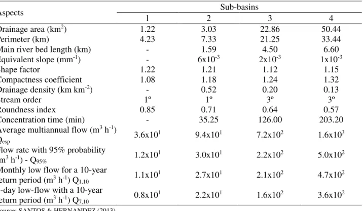
This micro-basin comprises an area of 50.44 km2 (7.7% of the city's area), being part of the Water Resources Management Unit of São José dos Dourados River (UGRHI-18).
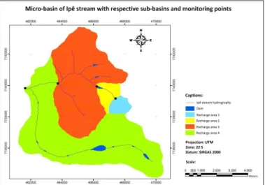
The micro-basin was divided into four strategic points (Figure 1; and Table 1) for characterization of the influence of the different land uses and occupation, as well as the contribution of the Córrego Das Lagoas stream, which is part of the study area.
FIGURE 1. Micro-basin of the Ipê stream and respective sub-basins and monitoring points.
TABLE 1. Physiographic characterization of the sub-basins of the Ipê stream micro-basin, Ilha Solteira, SP (Brazil).
Aspects Sub-basins
1 2 3 4
Drainage area (km2) 1.22 3.03 22.86 50.44
Perimeter (km) 4.23 7.33 21.25 33.44
Main river bed length (km) - 1.59 4.50 6.60
Equivalent slope (mm-1) - 6x10⁻³ 2x10⁻³ 1x10⁻³
Shape factor 1.22 1.21 1.12 1.15
Compactness coefficient 1.08 1.18 1.24 1.32
Drainage density (km km-2) - 0.52 0.20 0.13
Stream order 1º 1º 3º 3º
Roundness index 0.85 0.71 0.64 0.57
Concentration time (min) - 35.25 126.00 203.20
Average multiannual flow (m3 h-1)
Qesp 3.6x101 9.4x101 7.2x10² 1.6x10³
Flow rate with 95% probability
(m3 h-1) - Q95% 1.2x101 3.0x101 2.2x10² 5.0x10²
Monthly low flow for a 10-year
return period (m3 h-1) Q1,10 1.1x101 2.7x101 2.1x10² 4.7x10²
7-day low-flow with a 10-year
return period (m3 h-1) Q7,10 0.8x101 2.2x101 1.6x10² 3.6x10²
Source: SANTOS & HERNANDEZ (2013).
According to the Köppen's climatic classification, the city of Ilha Solteira presents a humid subtropical climate (Aw), with dry and mild winters and hot and rainy summers (ROLIM et al., 2007). The annual mean temperature is 25.1 °C, and rainfall is 1,306 mm year-1 (ÁREA DE HIDRÁULICA E IRRIGAÇÃO UNESP ILHA SOLTEIRA).
Land use and occupation and water quality
The influence of land use and occupation on the study characteristics was determined using data provided by SANTOS & HERNANDEZ (2013).
Water analyses were carried out from April 2006 to December 2011. In the years 2006, 2009, 2010, and 2011, water sampling was made monthly, whereas, in 2007, it was made bimonthly. It is noteworthy mentioned that there were no analyzes in 2008.
We performed physical, chemical, and biological analyses, being: temperature (T), total , dissolved and suspended solids (TS, DS and SS), turbidity (TU), pH, calcium (CA), magnesium (MG), total iron (Fe), electrical conductivity (EC), nitrite (NI), nitrate (NA), sulphate (SU), and fecal and total coliforms (FC and TC). The analytical methodology and parameters of irrigation water compliance followed the ones already proposed by SANTOS & HERNANDEZ (2013).
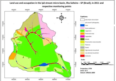
FIGURE 2. Land use and occupation in the Ipê stream basin, Ilha Solteira – SP (Brazil), and respective monitoring points.
Source: Adapted from SANTOS & HERNANDEZ (2013).
TABLE 2. Land use and occupation of the sub-basins in the Ipê stream basin, in 2011.
Land use and occupation Sub-basin 1 Sub-basin 2 Sub-basin3 Sub-basin4
%
Dam 0.6 1.4 0.3 1.2
Idle areas under conflict 0.6 0.4 2.8 2.1
Rural settlement 0.0 8.8 16.9 7.7
Sugarcane 84.3 42.2 50.2 48.1
Perennial crops 1.6 0.7 0.1 2.2
Vegetables 0.0 0.0 0.5 0.2
Woodland 0.0 0.0 0.2 0.6
Preservation areas
(woods) 1.9 1.0 0.7 0.6
Pastures 4.2 1.8 0.3 20.3
High density household 0.0 0.0 16.4 8.1
Low-density household 0.0 35.8 5.7 3.8
Roads 6.1 5.3 2.2 2.0
Wetlands 0.7 2.6 3.7 3.1
Source: SANTOS & HERNANDEZ (2013).
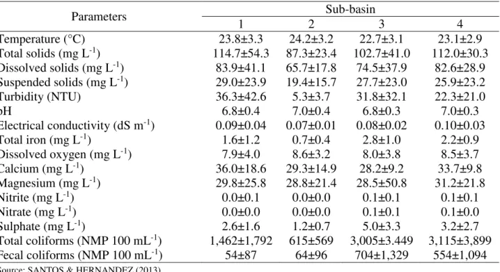
TABLE 3. Results of physical, chemical, and biological analyses of the sub-basins within the Ipê stream basin from April 2006 to December 2011.
Parameters Sub-basin
1 2 3 4
Temperature (°C) 23.8±3.3 24.2±3.2 22.7±3.1 23.1±2.9
Total solids (mg L-1) 114.7±54.3 87.3±23.4 102.7±41.0 112.0±30.3
Dissolved solids (mg L-1) 83.9±41.1 65.7±17.8 74.5±37.9 82.6±28.9
Suspended solids (mg L-1) 29.0±23.9 19.4±15.7 27.7±23.0 25.9±23.2
Turbidity (NTU) 36.3±42.6 5.3±3.7 31.8±32.1 22.3±21.0
pH 6.8±0.4 7.0±0.4 6.8±0.3 7.0±0.3
Electrical conductivity (dS m-1) 0.09±0.04 0.07±0.01 0.08±0.02 0.10±0.03
Total iron (mg L-1) 1.6±1.2 0.7±0.4 2.8±1.0 2.2±0.9
Dissolved oxygen (mg L-1) 7.9±4.0 8.6±3.2 8.0±3.8 8.5±3.7
Calcium (mg L-1) 36.0±18.6 29.3±14.9 28.2±9.2 33.7±9.8
Magnesium (mg L-1) 29.8±25.8 28.8±21.4 28.5±50.8 31.2±21.8
Nitrite (mg L-1) 0.0±0.1 0.0±0.0 0.1±0.1 0.1±0.1
Nitrate (mg L-1) 0.0±0.0 0.0±0.0 0.1±0.1 0.1±0.0
Sulphate (mg L-1) 2.6±1.6 1.2±0.7 5.0±3.3 3.2±2.7
Total coliforms (NMP 100 mL-1) 1,462±1,792 615±569 3,005±3.449 3,115±3,899
Fecal coliforms (NMP 100 mL-1) 54±87 64±96 704±1,329 554±1,094
Source: SANTOS & HERNANDEZ (2013).
Data analysis
Once there was no prior information on the formation of groups, hierarchical clustering (AA) identified the groups contained in the set of accesses. AA is a technique that maximizes the similarity of intra-group units at the same time that increases the distance between groups. It was processed with the Euclidean distance between accesses; and as a method for connection, the Ward method was used. The result is presented in a dendrogram graph that shows the group structure contained in the accesses.
The original dataset was resized to a set of new latent variables through principal component analysis (PCA). The main components are the eigenvectors, being built by the covariance matrix eigenvalues of the original variables. Each main component is a linear combination of two original variables. A two-dimensional plane formed by orthogonal main components with the distribution of accesses and the directions of the variable beams is called biplot and is a quite important tool in data analysis.
Factor analysis is an exploratory multivariate technique seeking to identify processes within a dataset. The factors were extracted by main components; and for a better interpretation of the results, they were rotated using a varimax orthogonal rotation criterion.
Variables with loads greater or equal to 0.7 (absolute value) were selected. The multivariate statistical analyses were processed using the STATISTICA software, version 7.0 (STATSOFT, 2004) after original variables standardization (null mean and unit variance).
RESULTS AND DISCUSSION
of land use and occupation. Sub-basin 2 presented a low concentration of the analyzed elements, mainly physical ones, which might be a result of flow speed reduction, however, with high potential of sedimentation.
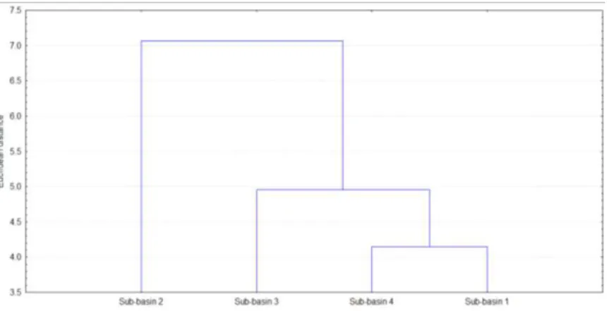
FIGURE 3. Dendrogram showing the similarity of monitoring points for water quality in the Ipê stream sub-basins, Ilha Solteira, SP.
The dendrogram showed to be an appropriate tool to define similarity between the studied areas. Results presented in this study corroborate those of ANDRADE et al. (2011) who investigated clustering techniques to identifying similarity in salt concentrations of irrigated fields.
As shown in Table 4, rotation factor analysis pointed out three distinct processes, being characterized as organic loads (VF1), mineral salts (VF2), and physical elements in water (VF3).
TABLE 4. Results of the factor analysis with principal component analysis by the varimax algorithm for water quality in the Ipê stream basin, Ilha Solteira, SP (Brazil).
Variables VF1 VF2 VF3
T -0.96 -0.08 -0.24
Fe 0.89 0.17 0.40
Ni 0.97 0.20 -0.01
Na 0.91 -0.19 0.35
Su 0.87 -0.00 0.47
TC 0.94 0.32 0.07
FC 0.99 -0.03 -0.00
Ca -0.35 0.91 0.17
Mg 0.13 0.92 -0.36
EC 0.27 0.91 0.30
DS 0.20 0.91 0.35
SS 0.38 0.54 0.75
TB 0.31 0.44 0.83
DO -0.06 -0.14 -0.98
pH -0.21 0.12 -0.96
Eigenvalue 8.63 3.81 2.55
% explained variance 57.56 25.43 17.00
% accumulated variance 57.56 82.99 100.0
Varimax Factor: VF, Temperature: T (°C), Dissolved solids: DS (mg L-1), Suspended solids: SS (mg L-1), Turbidity: TB (NTU), Hydrogen potential: pH, Electric conductivity: EC (dS m-1), Dissolved oxygen: DO (mg L-1), Calcium: Ca (mg L-1), Magnesium: Mg (mg L-1), Nitrite: Ni (mg L-1), Nitrate: Na (mg L-1), Sulphate: Su (mg L-1), Total coliforms: TC (NMP 100 mL-1), and Fecal coliforms: FC (NMP 100 mL-1).
temperatures. GUEDES et al. (2012) obtained similar results. Other authors also attributed such spring water degradation, nearby cities, to clandestine effluent discharges, damaging water multiple uses (VANZELA et al., 2010; POLETO et al., 2010; BERTOSSI et al., 2013a; SANTOS & HERNANDEZ, 2013). Biological contamination of spring water undermines the chances of using it for irrigation purposes, mainly for in natura consumption crops.
TERNUS et al. (2011) evaluated limnologic features of rivers crossing farming and urban areas, within the Upper Uruguay River basin, western Santa Catarina state (Brazil). As a result, they reported a high level of organic loads in the rivers passing through the urban areas; it was attributed to the disposal of untreated domestic and industrial sewage. In addition, the authors noted a reduction of riparian forests, which might have influenced the degradation of water bodies after the entering of pollutants.
The total iron content in water bodies arises from the type of soil comprising the studied area, for example, Red Latosol (rich in iron sesquioxides), eutrophic Red Argisol + Argisol, Red - Yellow Latosol and Quartzarenic Neosol. The presence of these soils associated with a natural degradation and poor soil conservation increases the levels of iron in the water. Therefore, irrigation systems in the studied basin may present problems related to obstruction of tubing and emitters, so it is required the use of filtration systems.
The second factor (VF2) was characterized by the presence of mineral salts and dissolved solids in the water. The later acts as a vehicle for the first to reach springs carried rainfall. Higher concentrations of salts and dissolved solids were recorded at points under influence of agricultural areas and low-density human settlements. Furthermore, soil intensive use with no soil management favors an increased carriage of particles containing mineral salts from farming areas.
These results agree with the report of VANZELA et al. (2010), who evaluated the Três Barras stream in Marinópolis city - SP (Brazil). They claimed an increase in the concentration of solids in water originated from agricultural and inhabited areas. Moreover, ZAMBERLAN et al. (2013) concluded that total iron and solids are the most impacting elements in spring waters to irrigation systems.
The third factor (VF3) was featured by physical elements in water (suspended solids and turbidity), acting inversely to pH and dissolved oxygen. The increase in sediments in water has reduced the amount of oxygen dissolved by displacement of organic and inorganic particles, which is detrimental to the aquatic life.
Notably, large amounts of sediment in water are most frequently found near agricultural lands, which are poor in soil conservation. These areas are marked by the presence of idle areas or in conflict, e.g. areas intended for permanent preservation being used in livestock management. Such conflicts have a direct influence on the organic and inorganic degradation of springs. For POLETO et al. (2010) and SANTOS & HERNANDES (2013), the establishment of small areas for permanent preservation, smaller than 37% of the total area, is one of the main causes of environmental degradation.
influence spring water quality, which due to a conservationist management, become major sediment sources of organic and inorganic origin.
FIGURE 4. Biplot graph of the water quality variables, land use and occupation together with the sub-basins of the Ipê stream, Ilha Solteira - SP (Brazil). Gráfico biplot das variáveis da qualidade de água, uso e ocupação do solo juntamente com as sub-bacias do córrego do Ipê, Ilha Solteira, SP.
Degradation of spring water quality may accentuate if these areas are increased. Likewise, GUEDES et al. (2012) claimed that physical and chemical degradation of water is a reflection of surface runoff from agricultural areas, domestic sewage, and solid waste disposed along the banks of the springs and streams.
These results corroborate those of BERTOSSI et al. (2013a) who assessed the quality of surface and subsurface waters in micro-basins with different soil coverage (pasture, forest, and coffee plantations).
POLETO et al. (2010) assessed the same area studied here and found evidence of lack of awareness and environmental perception by riparian people. These local communities neglected the need to preserve springs, what is alarming since irrigated farming is their main source of income. Thus, characterizing and monitoring a river basin becomes essential for understanding the dynamics thereof, thus being able to set guidelines for watercourse management.
If there is no management of the water resources, an increase of urban areas, as already assumed by the Municipal Land-use Planning, will lead to water quality degradation in the Ipê stream. It might be a consequence of an excess of organic loads and iron in the water, reducing its availability for irrigation purposes. In the same way, an increase in farming and scarcely populated areas, without proper management, may lead to a degradation of water physical quality, blocking pipes and sprinklers and, consequently, impairing irrigation quality and uniformity and ergo, the local economy.
CONCLUSIONS
Through multivariate techniques, three important factors on land use and occupation and water quality were identified in the studied basin. The first was the inverse action of temperature to the organic loads and total iron in the water. The second was related to mineral salts in water and dissolved solids. In addition, finally, the third emphasized the physical elements in the water acting inversely to pH and dissolved oxygen.
The housing areas enhanced degradation of the water by the inputting of organic loads, yet the agricultural areas were responsible for the degradation of the physical and chemical quality of the spring waters.
The knowledge of the land uses in the Ipê stream basin has favored the identification of environmental impacts. It may help establish guidelines for the hydro-agricultural and environmental planning of the area once all the involved factors are already known.
REFERENCES
ANDRADE, E. M.; MEIRELES, A. C. M.; ALEXANDRE, D. M. B.; PALÁCIO, H. A. Q.; LIMA, C. A. Investigação de mudanças do status salino do solo pelo emprego de análise multivariada. Revista Brasileira de Engenharia Agrícola e Ambiental, Campina Grande, v.15, n.4, p.410-415, abr. 2011. Disponível em: <http://www.scielo.br/pdf/rbeaa/v15n4/v15n04a13.pdf>. Acesso em: 20 maio 2016. DOI: 10.1590/S1415-43662011000400013
BERTOSSI, A. P. A.; CECÍLIO, R. A.; NEVES, M. A.; GARCIA, G. de O. Qualidade da água em microbacias hidrográficas com diferentes coberturas do solo no sul do Espírito Santo. Revista Árvore, Viçosa, MG, v.37, n.1, p.107-117, jan./fev. 2013a. Disponível em:
<http://www.scielo.br/pdf/rarv/v37n1/v37n1a12.pdf >. Acesso em: 15 maio 2016.
BERTOSSI, A. P. A.; MENEZES, J. P. C. de; CECÍLIO, R. A.; GARCIA, G. de O.; NEVES, M. A. Seleção e agrupamento de indicadores da qualidade de água utilizando estatística multivariada. Semina: Ciências Agrárias, Londrina, v.34, p.2025-2036, set./out. 2013b. Disponível em:
<http://www.uel.br/revistas/uel/index.php/semagrarias/article/view/10862/13319>. Acesso em: 16 maio 2016. DOI: 10.5433/1679-0359.2013v34n5p2025
GUEDES, H. A. S.; SILVA, D, D, da; ELESBON, A. A. A.; RIBEIRO, C. B. M.; MATOS, A. T. de; SOARES, J. H. P. Aplicação da análise estatística multivariada no estudo da qualidade da água do Rio Pomba, MG. Revista Brasileira de Engenharia Agrícola e Ambiental, Campina Grande, v.16, p.558-563, maio 2012. Disponível em:
<http://www.scielo.br/pdf/rbeaa/v16n5/v16n05a12.pdf>. Acesso em: 10 maio 2016. DOI: 10.1590/S1415-43662012000500012
POLETO, C.; CARVALHO, S. L. DE; MATSUMOTO, T. Avaliação da qualidade da água de uma microbacia hidrográfica no município de Ilha Solteira (SP). Holos Environment, Rio Claro, v.10, n.1, p.95-110, 2010. Disponível em:
<http://www.periodicos.rc.biblioteca.unesp.br/index.php/holos/article/view/4241/3421>. Acesso em: 8 maio 2016.
ROLIM, G. S.; CAMARGO, M. B. P.; LANIA, D. G.; MORAES, J. F. L. Classificação climática de Köppen e Thornthwaite e sua aplicabilidade na determinação de zonas agroclimáticas de zonas agroclimáticas para o estado de São Paulo. Bragantia, Campinas, v.66, p.711-720, 2007.
Disponível em: <http://www.scielo.br/pdf/brag/v66n4/22.pdf >. Acesso em: 1 maio 2016.
SANTOS, G. O.; HERNANDEZ, F. B. T. Uso do solo e monitoramento dos recursos hídricos no córrego do Ipê, Ilha Solteira, SP. Revista Brasileira de Engenharia Agrícola e Ambiental, Campina Grande, v.17, n.1, p.60-68, 2013. Acesso em:
<http://www.agriambi.com.br/revista/v17n01/v17n01a09.pdf>. Acesso em: 10 abr. 2016. DOI: 10.1590/S1415-43662013000100009
STATSOFT. Statistica 7.0. Tulsa: StatSoft, 2004. p.250.
VANZELA, L. S.; HERNANDEZ, F. B. T.; FRANCO, R. A. M. Influência do uso e ocupação do solo nos recursos hídricos do córrego Três Barras, Marinópolis. Revista Brasileira de Engenharia Agrícola e Ambiental, Campina Grande, v.14, p.55-64, 2010. Disponível em:
<http://www.scielo.br/pdf/rbeaa/v14n1/v14n01a08.pdf >. Acesso em: 22 maio 2016. DOI: 10.1590/S1415-43662010000100008
ZAMBERLAN, J. F.; ROBAINA, A. D.; PEITER, M. X.; FERRAZ, R. C.; PINTO, L. de M. Índices sazonais de qualidade da água de irrigação via análise multivariada na região central do Rio Grande do Sul. Irriga, Botucatu, v.18, n.3, p.376-386, jun./set. 2013. Disponível em: