www.ambi-agua.net E-mail: [email protected]
This is an Open Access article distributed under the terms of the Creative Commons Attribution License, which permits unrestricted use, distribution, and reproduction in any medium, provided the original work is properly cited.
Validation of rainfall data estimated by GPM satellite on Southern
Amazon region
ARTICLES doi:10.4136/ambi-agua.2249
Received: 04 Mar. 2018; Accepted: 01 Nov. 2018
Luiz Octavio Fabricio dos Santos1 ; Carlos Alexandre Santos Querino2* ;
Juliane Kayse Albuquerque da Silva Querino2 ; Altemar Lopes Pedreira Junior1 ;
Aryanne Resende de Melo Moura1 ; Nadja Gomes Machado3 ;
Marcelo Sacardi Biudes4
1Universidade Federal do Amazonas (UFAM), Humaitá, Amazonas, Brasil
Instituto de Educação, Agricultura e Ambiente (IEAA). E-mail: [email protected], [email protected], [email protected]
2Universidade Federal do Amazonas (UFAM), Humaitá, Amazonas, Brasil
Instituto de Educação, Agricultura e Ambiente (IEAA). Programa de Pós-graduação em Ciências Ambientais. E-mail: [email protected], [email protected]
3Instituto Federal de Educação, Ciência e Tecnologia de Mato Grosso (IFMT), Cuiabá, MT, Brasil
Departamento de Ensino. Programa de Pós-Graduação em Física Ambiental (PPGFA). E-mail: [email protected]
4Universidade Federal de Mato Grosso (UFMT), Cuiabá, MT, Brasil
Instituto de Física. Programa de Pós-Graduação em Física Ambiental (PPGFA). E-mail: [email protected]
*Corresponding author
ABSTRACT
Rainfall is a meteorological variable of great importance for hydric balance and for weather studies. Rainfall estimation, carried out by satellites, has increased the climatological dataset related to precipitation. However, the accuracy of these data is questionable. This paper aimed to validate the estimates done by the Global Precipitation Measurement (GPM) satellite for the mesoregion of Southern Amazonas State, Brazil. The surface data were collected by the National Water Agency – ANA and National Institute of Meteorology – INMET, and is available at both institutions’ websites. The satellite precipitation data were accessed directly from the NASA webpage. Statistical analysis of Pearson correlation was used, as well as the Willmott’s “d” index and errors from the MAE (Mean Absolute Error) and RMSE (Root Mean Square Error). The GPM satellite satisfactorily estimated the precipitation, once it had correlations above 73% and high Willmott coefficients (between 0.86 and 0.97). The MAE and RMSE showed values that varied from 36.50 mm to 72.49 mm and 13.81 mm to 71.76 mm, respectively. Seasonal rain variations are represented accordingly. In some cases, either an underestimation or an overestimation of the rain data was observed. In the yearly totals, a high rate of similarity between the estimated and measured values was observed. We concluded that the GPM-based multi-satellite precipitation estimates can be used, even though they are not 100% reliable. However, adjustments in calibration for the region are necessary and recommended.
Rev. Ambient. Água vol. 14 n. 1, e2249 - Taubaté 2019
Validação dos dados de precipitação estimados pelo satélite GPM na
região sul do Amazonas
RESUMO
A precipitação é a variável meteorológica de maior importância para o balanço hídrico e estudo do clima. As estimativas de precipitação feitas por satélites têm contribuído para aumentar o conjunto de dados climatológicos relacionados a chuva. Entretanto, o nível de confiança destes dados é questionável. O objetivo deste artigo foi validar os dados estimados pelo satélite Global Precipitation Measurement (GPM) para a mesorregião Sul do Estado do Amazonas, Brasil. Os dados de superfície foram coletados da Agência Nacional de Águas (ANA) e do Instituto Nacional de Meteorologia (INMET), disponibilizados no site de ambas as instituições. Os dados estimados foram acessados diretamente no site da NASA. Foi utilizada análise estatística de correlação de Pearson, índice “d” de Willmott, e erros Erro Médio Absoluto (MAE) e Erro Médio Quadrático da Raiz (RMSE). O Satélite GPM estimou de maneira satisfatória a precipitação, pois obteve correlações superiores a 73% e altos coeficiente
de Wilmott (entre 0.86 a 0.97). O MAE e RMSE apresentaram valores que variaram de (36.50 mm a 72.49 mm) e (13.81 mm a 71.76 mm), respectivamente. As variações sazonais da
chuva foram bem representadas. Em alguns casos, foi observada subestimação ou superestimação dos dados de chuva. Nos totais anuais, observou-se uma alta taxa de similaridade entre os valores estimados e medidos. Conclui-se que as estimativas do GPM podem ser utilizadas, mas não com 100% de confiabilidade. Dessa maneira, é necessário que haja uma calibração para a região local.
Palavras-chave: análise estatística, monitoramento climático, sensoriamento remoto.
1. INTRODUCTION
Amazonas is one of the states with the lower indexes of deforested area in the Legal Amazon region. However, the Southern Amazonas region has been consolidating as a new expansion area for agriculture and cattle raising and, consequently, has the largest deforested area in the state (Macedo and Teixeira, 2009). Deforestation provokes microclimatic changes that may cause alterations in the functioning of the Amazon rainforest dynamics. These changes cause a gradual process of savanization due to alterations in the hydrologic cycle of this ecosystem (Marengo and Betts, 2011).
The hydrological cycle in a certain region is directly related with its topography, geology, physical mechanisms and the climate, of which precipitation (Ppt) is the most important phenomenon. Ppt is considered as a preponderant system that modifies environmental dynamics and is a variant of environmental balance and natural processes. (Girão and Corrêa, 2004). Thus, characterizing Ppt over a region enables better planning for agricultural practices, soil structure conservation, construction (drainage channels and dams), weather forecasting and the use of hydric resources (Reis, 2014).
To monitor rainfall, it is necessary to use specific tools (pluviometers) to measure it in loco. However, the lack of Ppt data in the Southern Amazonas region generates a demand for the use of alternative measures such as, for instance, the use of remote sensing by satellites. This information is extremely important for regions with high rainfall rates, since they may contribute to rainfall data collection and analysis.
Rev. Ambient. Água vol. 14 n. 1, e2249 - Taubaté 2019 improve rainfall estimates from microwave sensors. The GPM satellite was built to replace the Tropical Rainfall Measurement Mission (TRMM), with the aim of providing a new generation of remote observations of rain and snow (Hou et al., 2014).
Recently studies have compared the performances of the TRMM and GPM satellites. In both cases, the Ppt estimates have shown quality, even at a regional or global scale. However, the GPM satellite has performed better, because it has advanced technology when compared with the TRMM (Liu, 2016; Prakash et al., 2018).
Fusions of the rainfall measurement method using rain gauges with the estimates provided by satellites enable the validation of estimated satellite data (GPM) and mitigate the consequences of environmental disasters. This study therefore sought to evaluate and validate rainfall estimates from the GPM satellite in the Southern Amazonas region, compared with the measured data collected at the ground stations.
2. MATERIALS AND METHODS
2.1. Study area
The municipalities of Humaitá (HT; 7.30° S, 63.01° W and 58 m), Boca do Acre (BA;
8.45° S, 67.23° W and 116 m), Manicoré (MN; 5.48° S, 61.18° W, and 45m), Apuí (AP; 7.11° S, 59.53° W and 135 m) and Lábrea (LB; 7.15° S, 64.47° W and 75 m) are located
in the Northern region of Brazil, in the South of the Amazonas State (Figure 1). This region covers an area of modifications between the ecosystems of dense forests and natural fields mainly composed of grasses and low mesophilic surrounding forests, high evergreen forests, palm trees, Brazilian nut trees and others (Pavão et al., 2016).
The climate in the study area, according to Köppen's classification, is rainy tropical, in other words, a short dry season (June through August) and a long rainy season (October through March) with no hydric deficit. The annual average rainfall is of 2500 mm and the average temperature is of 25°C (Vidotto et al., 2007).
Rev. Ambient. Água vol. 14 n. 1, e2249 - Taubaté 2019
2.2. Data
In this study, we have used data from the GPM_3IMERGM v04 final run. In this algorithm, the IMERG shows data latency of 2 months after the observation period, allowing correction and a better estimate process. Afterwards, the data collected and estimated by Global Precipitation Mission (GPM) are available in the National Aeronautics and Space Administration (NASA) website (https://giovanni.gsfc.nasa.gov/). We have used data for the period of 2015 and 2016 covering the Southern Amazonas region. At the surface, we have used the records from rainfall measurement stations of the Agência Nacional de Águas – ANA
(National Water Agency) (http://hidroweb.ana.gov.br/default.asp) and the meteorological stations of the Instituto Nacional de Meteorologia –INMET (National Meteorology Institute) which are deployed in the study area.
The Ppt estimates were taken considering the same coordinates of each surface station as a GPM central point of grid, which covers an area of 10 x 10 km. We highlight that according to the World Meteorological Organization (WMO), report n. 544, the horizontal radius of a weather station would not exceed 250 km, or 300 km in sparsely populated regions (WMO, 2003), fitting perfectly with the observed area of a GPM satellite.
2.3. Statistical analysis
The data were processed on the basis of yearly and monthly averages. The relation between the measured values and the estimated ones was made through the Pearson “r” correlation index, the analysis of accuracy through Willmott “d” index (Equation 1), which links the distance of the estimated values in comparison with the observed ones, and its values vary between 0, for no matching, and 1, for perfect matching (Machado et al., 2015). The Root Mean Square Error - RMSE (Equation 2) was also analyzed, indicating that the model presents failures in the comparison between the estimated and the measured values, and the Mean Absolute Error - MAE (Equation 3), which indicates the absolute mean distance (deviation) between the estimated and measured values. In both errors, the values must be close to zero (Machado et al., 2015).
𝑑 = 1 − [ ∑(𝑃𝑖−𝑂𝑖)2
∑(|𝑃𝑖−𝑂|+|𝑂𝑖−𝑂|)2] (1)
𝑅𝑀𝑆𝐸 = √∑(𝑃𝑖− 𝑂𝑖)2
𝑛 (2)
𝑀𝐴𝐸 = ∑|𝑃𝑖 − 𝑂𝑖|
𝑛 (3)
Where P1 are estimated values, Oi are observed values, O the average of the observed
values, and n indicates the total number of samples.
3. RESULTS AND DISCUSSION
The municipalities of HT and AP had the lowest errors and the highest “r” values, respectively (Table 1). A Ppt underestimation by the GPM was observed. However, in general, the GPM adequately estimated the monthly and yearly rainfall values with correlations above 73%. The municipality of Lábrea presented a higher MAE and a lower correlation. BA had the highest RMSE and MN had a good correlation.
Rev. Ambient. Água vol. 14 n. 1, e2249 - Taubaté 2019 meteorological stations can be considered as a result of the distinction of scale among them. The pluviometer presents a specific estimate, whereas the satellite represents a mean estimate in the analyzed pixel, which, together with the characteristics of each region, may cause different correlations in distinct areas (Almeida et al., 2015), once IMERG can present systematic differences due to surface type and precipitation rates (Liu, 2016). Another explanation is the fact that there is no predisposition from these estimative models to systematically over - or underestimate the rainfall measurements (Collischonn, 2006). A study comparing the monthly integration of multisatellite retrievals for the GPM has also observed positive and negatives differences over land regions (Liu, 2016). The author also has noticed that difference is more significant in regions near the ITCZ.
GPM errors, whether too high or too low, are related to the nature of the analyzed event. The estimative correlation therefore can be strongly affected by examined areas which are close to the measuring stations where no Ppt was recorded. On the other hand, in the observed cells that are distant from the rainfall measuring stations, the events of higher intensity are minimized due to the smooth essence of the data interpolation by the inverse of the distance towards the square. Therefore, the Ppt series approximates the most consistent average measured values (Almeida et al., 2015; Collischonn, 2006). Similar results have been found in a study carried out in India, where monthly variations of mean rainy days and heavy rain events showed good agreement to based-gauge observations (Prakash et al., 2018).
Table 1. Statistical indicators of the relation between the mean rainfall and the estimated for the municipalities of Apuí (AP), Boca do Acre (BA), Humaitá (HT), Lábrea (LB) and Manicoré (MN) in Southern Amazonas State, Brazil. MAE:
Mean Absolute Error. RMSE: Root Mean Square Error. “r”: Pearson correlation index.“d”: Willmott index. *, p < 0.05; **, p < 0.01; ***, p < 0.001.
City MAE RMSE “d” “r”
AP 36.50 13.81 0.97 0.95***
BA 56.92 71.76 0.91 0.85***
HT 49.34 19.73 0.91 0.86***
LB 72.49 23.42 0.84 0.74**
MN 41.47 17.44 0.83 0.86***
The GPM, in general, underestimated the rainfall records (Table 2). The highest underestimation was observed in the municipality of HT (16%) and the lowest in MN (2%). In BA, an overestimation of 12% was observed. In the wet season, in HT, the highest difference (15%) of underestimation was observed and the lowest value was observed in AP (3%). In the dry season, the satellite also inclined to underestimate in the municipality of LB with a dissimilar difference (262%). In the municipality of MN, there was an overestimation (41%). A study conducted in India to detect heavy rainfall event frequency by using IMERG and compare it with gauge-based observations, showed great results (Prakash et al., 2016). This lowest underestimation can be explained by the high frequency of rain events during the wet season (Pedreira Junior et al., 2018), while the discrepancies during the dry season are consequences of convective and stratiform rain reduction, which are more evident in the rainy season.
Rev. Ambient. Água vol. 14 n. 1, e2249 - Taubaté 2019
Table 2. Annual and season variability of the measured and estimated rainfall for the municipalities of Apuí (AP), Boca do Acre (BA), Humaitá (HT), Lábrea (LB) and Manicoré (MN), in the Southern Amazonas State, Brazil. WS: Wet Season; DS: Dry Season.
Municipalities Measured (mm) Estimated (mm) Differences (mm) Annual WS DS Annual WS DS Annual WS DS
AP 1936 1782 154 1822 1725 96 -114 -57 -58
BA 1946 1820 126 2200 2112 88 254 293 -38
HT 2105 2024 81 1822 1761 61 -283 -263 -20
LB 2132 1896 237 2056 1991 66 -76 95 -171
MN 2417 2297 119 2358 2156 202 -59 -141 82
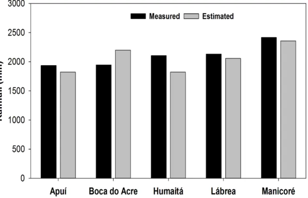
In the period of 2015 and 2016, the satellite yearly average was 2052 mm year-1, while the
surface average was 2109 mm year-1 (Figure 2). The best estimate results are the ones for the
municipality of MN and the worst performance was observed in the municipality of HT. The yearly mean spatial variability of precipitation estimated by the GPM satellite in the years of 2015 and 2016 were concentrated in the Northern part of Southern Amazonas State (Figure 3). In 2015, a set with rainfall values varying between 98 and 250 mm month-1 was observed in
this region. In average terms, the estimated values correspond greatly to values measured by the gauge-based values, both in temporal and spatial distribution. In 2016, the spatial variability
of rainfall had a more homogeneous character all over the region, with values from 115 to 250 mm month-1.
These values are associated with the meteorological systems that operate in this region, such as the South Atlantic Convergence Zone (ZCAS), the South American Monsoonal System (SMAS), the Intertropical Convergence Zone (ZCIT), the Instability Lines (LI), the Bolivian High Pressures (AB) and front systems (cold fronts) (Rickenbach, 2004; Vera et al., 2006).
Rev. Ambient. Água vol. 14 n. 1, e2249 - Taubaté 2019 Figure 3. Yearly mean spatial variability of estimated rainfall by the GPM satellite in the
Southern Amazonas State in 2015 and 2016. A: Apuí, B: Boca do Acre, C: Humaitá, D:
Rev. Ambient. Água vol. 14 n. 1, e2249 - Taubaté 2019
4. CONCLUSION
The rainfall estimates provided by the GPM are consistent and can satisfactorily reflect precipitation occurrences in Southern Amazonas State (Brazil). The statistical indicators show that there is a rainfall correlation between these two methods with its multiple r presenting a descriptive value in the quality of the obtained adjustment.
Seasonal variations of the rain are represented accordingly. In some cases, either an underestimation or an overestimation of the rain data was observed. In the yearly totals, a high rate of similarity between the estimated and measured values was observed.
Finally, this paper highlights that the GPM estimates can be used, even though they are not 100% reliable. Thus, studies that may generate adjustment equations for better estimates are expected in the future.
5. ACKNOWLEDGEMENTS
We appreciate the support given by the Programa Institucional de Bolsas de Iniciação Científica – IC (Institutional Program of Scientific Initiation Scholarship) induced demand - PIBMULT - multidisciplinary - UFAM, Project Number PIB-E / 0437/2017 for the concession of PIBIC Scientific Initiation for the first author. This study’s authors are also thankful to the
Instituto Nacional de Meteorologia – INMET, the Agencia Nacional de Aguas – ANA and the National Aeronautics and Space Administration - NASA for its data availability.
6. REFERENCES
ALMEIDA, C. T. C.; OLIVEIRA JUNIOR, J. F.; GOIS, G.; CAVALCANTI, A. S. Avaliação das Estimativas de Precipitação do Produto 3B43-TRMM do Estado do Amazonas.
Revista Floresta e Ambiente, v. 22, p. 279-286, 2015. https://doi.org/10.1590/2179-8087.112114
ANJOS, R. S.; NÓBREGA, R. S.; ARAÚJO, F. E.; ROCHA FILHO, G. B. R. Spatial distribution of rain types in Pernambuco with the usage of Remote Sensing. Journal of Hyperspectral Remote Sensing, v. 6, n. 3, p. 154-163, 2016. http://dx.doi.org/10.5935/2237-2202.20160016
COLLISCHONN, B. Uso de precipitação estimada pelo satélite TRMM em modelo hidrológico distribuído. 2006. Dissertação (Mestrado em recursos hídricos e saneamento ambiental) - Universidade Federal do Rio Grande do Sul, Porto Alegre, 2006. GIRÃO, O.; CORRÊA, A. C. B. A contribuição da geomorfologia para o planejamento da
ocupação de novas áreas. Revista de Geografia, v. 21, n. 2, 2004.
HOU, Y. A.; KAKAR, R. K.; NEECK, S.; AZARBARZIN, A. A.; KUMMEROW, C. D.; KOJIMA, M. et al. The Global Precipitation Measurement Mission. American Meteorological Society, 95, p. 701- 722, 2014. https://doi.org/10.1175/BAMS-D-13-00164.1
Rev. Ambient. Água vol. 14 n. 1, e2249 - Taubaté 2019 MACEDO, A. M.; TEIXEIRA, W. Sul do Amazonas, nova fronteira agropecuária? O caso do
município de Humaitá. In: SIMPÓSIO BRASILEIRO DE SENSORIAMENTO REMOTO, 14., 2009. Anais... São José dos Campos, 2009.
MACHADO, N. G.; MEIRELLES, T.; DANELICHEN, V. H. M.; QUERINO, C. A. S.; BIUDES, M. S. Estimation of Rainfall by Neural Network Over a Neotropical Region.
Revista Brasileira de Climatologia, v. 17, p. 44 - 54, 2015. http://dx.doi.org/10.5380/abclima.v17i0.40799
MARENGO, J. A.; BETTS, R. Riscos das mudanças climáticas no Brasil. Análise conjunta Brasil-Reino Unido sobre os impactos das mudanças climáticas e do desmatamento na Amazônia. São Paulo: CCST-INPE; 2011.
PAVÃO, V. M.; QUERINO, C. A. S.; BENEDITTI, C. A.; PAVÃO, L. L.; QUERINO, J. K. A. S.; MACHADO, N. G. et al. Variação espacial e temporal do saldo de radiação superficial em uma área do sul do Amazonas, Brasil. RA'E GA - O Espaco Geografico em Analise, v. 37, p. 333-352, 2016. http://dx.doi.org/10.5380/raega.v37i0.42469 PEDREIRA JUNIOR, A. L.; QUERINO, C. A. S.; QUERINO, J. K. A. S.; SANTOS, L. O. F.;
MOURA, A. R. M.; MACHADO, N. G. et al. Variabilidade horária e intensidade sazonal da precipitação no município de Humaitá - AM. Revista Brasileira de Climatologia, v. 22, p. 463-475, 2018. http://dx.doi.org/10.5380/abclima.v22i0.58089
PRAKASH, S.; MITRA, A. K.; AGHAKOUCHAK, A.; LIU, Z.; NOROUZI, H.; PAI, D. S. A preliminary assessment of GPM-based multi-satellite precipitation estimates over a monsoon dominated region. Journal of Hydrology. v. 556, p. 865-876, 2018. https://doi.org/10.1016/j.jhydrol.2016.01.029
PRAKASH, S.; MITRA, A. K.; PAI, D. S; AGHAKOUCHAK, A. From TRMM to GPM: How well can heavy rainfall be detected from space. Advances in Water Resources. v. 88, p. 1-7, 2016.
PSCHEIDT, I. BENETI, C.; CALVETTI, L. Validação das estimativas de chuva por satélite para o estado do Paraná. In: CONGRESSO BRASILEIRO DE METEOROLOGIA, 15., São Paulo, 2008. Anais... Rio de Janeiro: SBMET, 2008.
REIS, J. B. C. Monitoramento e alerta de inundação no município de itajubá (MG) através de modelos matemáticos. 2014, Dissertação (Mestrado em Meio Ambiente e Recursos Hídricos) - Universidade Federal de Itajubá, Itajubá, 2014.
RICKENBACH, T. M. Nocturnal cloud systems and the diurnal variation of clouds and rainfall in Southwestern Amazonia. Monthly Weather Review, v. 132, p. 1201-1219, 2004. https://doi.org/10.1175/1520-0493(2004)132%3C1201:NCSATD%3E2.0.CO;2
VERA, C.; HIGGINS, W.; AMADOR, J.; AMBRIZZI, T.; GARREAUD, R.; GOCHIS, D. et al. Towards a unified view of the American Monsoon System. Journal Climate 19, 4977-500, 2006. https://doi.org/10.1175/JCLI3896.1
VIDOTTO, E.; PESSENDA, L.C. R.; RIBEIRO, A. S.; FREITAS, H. A.; BENDASSOLLI, J. A. Dinâmica do ecótono floresta-campo no sul do estado do Amazonas no Holoceno, através de estudos isotópicos e fitossociológicos. Acta Amazônica, v. 37, n. 3, p. 385– 400, 2007.