www.ambi-agua.net E-mail: [email protected]
This is an Open Access article distributed under the terms of the Creative Commons Attribution License, which permits unrestricted use, distribution, and reproduction in any medium, provided the original work is properly cited.
Analysis and modeling of water quality as a contribution to the
preliminary framework proposal for the Una River
(Pernambuco/Brazil)
ARTICLES doi:10.4136/ambi-agua.2251
Received: 09 Mar. 2018; Accepted: 12 Oct. 2018
Simone Rosa da Silva1; Marcos Antonio Barbosa da Silva Junior2*;
Eduardo Elvino Sales de Lima3
1Universidade de Pernambuco (UPE), Recife, PE, Brasil
Departamento de Engenharia Civil. E-mail: [email protected]
2Universidade Federal de Pernambuco (UFPE), Recife, PE, Brasil
Departamento de Engenharia Civil. E-mail: [email protected]
3Agência Estadual de Meio Ambiente (CPRH), Recife, PE, Brasil
E-mail: [email protected]
*Corresponding author
ABSTRACT
The present paper presents a preliminary proposal for a framework for the Una River, located in the state of Pernambuco, divided into prevailing-use classes. This proposal integrates the results of an analysis of water quality parameters and a mathematical modeling performed along a section of the river. Data from six State Environmental Agency (CPRH) monitoring stations were used, which collected data for temperature, pH, DO, BOD, phosphorus, thermotolerant coliforms, turbidity, and color between 2002 and 2014. The mathematical model used was QUAL-UFMG and the parameters evaluated were DO and BOD. The results showed that the DO and BOD parameters were within the limits established by CONAMA Resolution No. 357/2005 for Class 2, but other parameters such as phosphorus presented nonconformities. Based on this, the proposed framework for the Una River covered Classes 1 and 2. It is hoped that such a proposal will serve as a reference for the basin committee in order to discuss and deliberate on the multiple uses preponderant along the river, aiming to approve and implement the framework.
Keywords: framework, Una river, water quality.
Análise e modelagem da qualidade da água como subsídio à proposta
preliminar de enquadramento do rio Una (Pernambuco/Brasil)
RESUMO
Rev. Ambient. Água vol. 13 n. 6, e2251 - Taubaté 2018
Na modelagem matemática, o modelo utilizado foi o QUAL-UFMG e os parâmetros avaliados foram o OD e DBO. Os resultados mostraram que os parâmetros de OD e DBO ficaram dentro dos limites estabelecidos pela Resolução CONAMA nº 357/2005 para a Classe 2, porém outros parâmetros como o fósforo apresentaram desconformidades em seus índices. Com base nisso, o enquadramento preliminar proposto para o rio Una abrangeu as Classes 1 e 2. Espera-se que tal proposta sirva como referência ao comitê da bacia, para que sejam discutidos e deliberados os usos múltiplos preponderantes ao longo do rio, objetivando assim, a aprovação e implementação do enquadramento.
Palavras-chave: enquadramento, qualidade da água, rio Una.
1. INTRODUCTION
The term “framework” refers to the definition of quality goals to be achieved for water
bodies within a river basin. In Brazil, the National Water Resources Policy (Federal Law nº 9.433/1997) establishes that the framework for water bodies divided into prevailing use classes, as defined by CONAMA Resolution nº 357/2005, should guarantee the necessary water quality standards for the most restrictive uses. In basins where the current condition of the water body quality is not appropriate for its intended uses, targets should be established to implement the respective frameworks, as recommended by CNRH Resolution nº 091/2008 (Brasil, 1997; CONAMA, 2005; CNRH, 2008).
In order to simulate water quality parameters in compliance with the proposed framework, simplified one-dimensional mathematical models are commonly used, which represent flow through the average velocity in the cross section, neglecting the vertical and transverse variations. With the advancement of computing, it is possible to perform spatially distributed modeling using geographic information systems (GIS), allowing the integration between point and diffuse pollution sources. These models can also be integrated into decision support systems for water-resource management in a watershed (Fan et al., 2012; Gomes and Simões, 2014; Silva et al., 2017).
The Una River basin does not have a framework prevailing use class. In the absence of this instrument, current legislation (CONAMA nº 357/2005) establishes that fresh water bodies are to be considered Class 2. According to the Pernambuco State Water Resources Policy (State Law nº 12.984/2005, Article 55, XI and Article 47, VI), the proposed framework should be made by the Basin Agency, approved by the Basin Committee and later ratified by the State Council of Water Resources. In the absence of the Basin Agency, the above-mentioned State Law (Article 48, XIII) assigns responsibility for the elaboration of said proposal to the management and environmental body (Pernambuco, 2005).
With the goal of contributing as a theoretical subsidy for future framework proposals in the Una River basin, the present article presents a preliminary study for the classification of the main river into a prevailing-use class, based on the analysis of water quality parameters, mathematical modeling, and current water use.
2. MATERIALS AND METHODS
2.1. Characterization of the study area
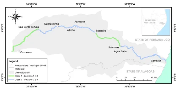
Rev. Ambient. Água vol. 13 n. 6, e2251 - Taubaté 2018 Figure 1. Map showing the location of the Una River hydrographic basin.
The most significant uses for the water in the basin are focused on public water supply and irrigation of short- and long-cycle crops. Due to the use and occupation of the soil (which houses urban areas, public slaughterhouses, industries, polyculture and sugar cane cultivation), the Una River became a receptacle for domestic, agroindustrial, and industrial effluents (the main source of pollution). According to Lima (2016), the release of industrial effluents decreased significantly with the deactivation of several sugar and alcohol sector plants in the basin. Only the Pumaty Plant, located in the municipality of Palmares, remains in operation. Despite this, sugarcane plantations continue across large parts of the basin, provoking an increase in nutrient concentration in the Una River, due to fertirrigation practices.
In this current situation, the water quality of the Una River is moderately compromised. The results of the monitoring carried out in December 2017 by the State Environmental Agency (CPRH) indicate that the river has regular water quality conditions (with acceptable levels of pollution) and is compatible with the limits of Class 3 (CPRH, 2018).
The Una River Basin Committee (COBH Una, in Portuguese) was created by CRH/PE Resolution nº 005/2002. It has 24 members for the 2015-2018 term, these being 12 representatives of the municipal, state, and federal governments, 8 representatives of water users in the basin, and 4 representatives of civil entities. Currently, the Una River basin has no master water plan nor any framework, as already mentioned. In general, the focus of the attention of COBH Una is controlling flooding, which has caused significant damages in several municipalities in the basin during 2010 and 2017.
2.2. Water quality monitoring data
Rev. Ambient. Água vol. 13 n. 6, e2251 - Taubaté 2018
2.3. Modeling the QUAL-UFMG water quality model
The QUAL-UFMG model, developed by Von Sperling (2007) as an adaptation of the QUAL2E model, has been widely used by many Brazilian researchers to evaluate water quality, simulate scenarios, and predict water body behavior. It is a one-dimensional model, developed in a Microsoft Office Excel spreadsheet, suitable for rivers with relatively low permanent flows. It allows the modeling of river water quality through a simple and fast simulation of dissolved oxygen, biochemical oxygen demand, total nitrogen and its concentration, and coliform bacteria (Louzada Valory et al., 2016).
The choice of the above-mentioned model was based on the following criteria: ease of use, considering both the interface and the language; the utilization of basic parameters to qualitatively evaluate water resources (DO, BOD, phosphorus, thermotolerant coliforms, temperature, pH, color, and turbidity); availability of water quality monitoring data over a 10-year period; and data on the flow of the water body to be modeled. In addition, this model had been previously used with other basins in Pernambuco, producing satisfactory results (Pinheiro et al., 2013; Araújo, 2013; Silva, 2015; Lima, 2016).
Although up to 15 organic components of water quality were simulated, two basic parameters were used to perform this study: dissolved oxygen (DO) and biochemical oxygen demand (BOD). To model DO and BOD in watercourses, Equation 1 is used to calculate the weighted average of the concentrations with the aggregated element flows. It is observed that the value of C0 is obtained through a weighted average of the flows, DO and BOD.
𝐶0 = 𝑄𝑟×𝐶𝑄𝑟𝑟+𝑄+𝑄𝑒𝑟×𝐶𝑒 (1)
Where: C0 (DO or BOD5): concentration of the mixture (mg L-1); Cr (DOr or BODr): concentration in the river upstream from the mixing point (mg L-1); Ce (DOe or BODe): concentration in the sewer upstream from the mixing point (mg L-1); and Qr and Qe: flows of the river and of the sewer (m3 s-1).
The section to be modeled was defined based on the size of the series of historical flow and water quality data (DO and BOD) available at stations along the Una River. With this criterion, the data series from two ANA fluviometric stations (Palmares - code 39560000 and Barreiros - code 39590000) and three CPRH water quality stations (18, 42, and UN-45) were considered satisfactory, resulting in a modeled stretch 118 km long (Figure 1).
It is important to note that other relevant points were considered during the modeling, such as the inclusion of pollution sources from the sugar and alcohol sector (represented by the Pumaty Plant, the only one currently in operation) and the organic load resulting from the sewage of the municipalities of Palmares, Água Preta and Barreiros, as well as from their respective public slaughterhouses. The input data required and used by the QUAL-UFMG water quality mathematical model are presented below in a simplified manner:
Rev. Ambient. Água vol. 13 n. 6, e2251 - Taubaté 2018
𝑄𝑒= [(𝑄𝑃𝐶1000×𝑃𝑜𝑝×𝑅)] ÷ 8640 (2)
Where: Qe: average domestic sewage flow (m3 s-1); QPC: per capita water quota (L hab-1 d-1); Pop: population (hab); and R: coefficient of return.
● Dissolved oxygen in the river (DOr), BOD5,20 in the river (BODr) and water temperature
(T): these parameters were obtained from the average data of the six water quality monitoring stations between 2002 and 2010, for the dry period only.
● Dissolved oxygen in the sewage (DOe) and BOD5,20 in the sewage (BODe): as most
sewage from the municipalities as well as from public slaughterhouses is not treated, for the self-purification calculations, the DOe was considered to be 0 mg L-1. The BODe was estimated by the division between the of BOD5 load (kg d-1) and the sewage flow (m3 d-1).
● River velocity (v), river depth (H), and travel time (t): velocity and depth were inferred from the key curve at the selected fluviometric stations, using the cross section and the level series, both obtained from Hidroweb. The travel time was obtained by the ratio between the length of the river section and the velocity.
● DO saturation concentration (Cs): obtained as a function of river water temperature, ranging from 0°C = 14.6 mg L-1 to 40°C = 6.4 mg L-1 (Collischown and Tassi, 2010). ● Minimum permissible DO (DOmin) and maximum permissible BOD (BODmax): for
DOmin and BODmax in the river, the value of 5.0 mg L-1 was adopted, according to CONAMA Resolution nº 357/2005 (CONAMA, 2005) for Class 2.
● Coefficients of deoxygenation (K1), decomposition (Kd). and reaeration (K2): the K1
value depends on the temperature because it exerts considerable influence on microbial metabolism. The empirical relationship between temperature and the deoxygenation rate is given by Equation 3:
𝐾1𝑇 = 𝐾120× 𝜃(𝑇−20) (3)
Where: 𝐾1𝑇: K1 at any temperature T (d-1); 𝐾
120: K1 at temperature T = 20°C (d
-1); T: water
temperature (°C); and θ: temperature coefficient (dimensionless). The coefficients Kd and K2 can also be defined by Equation 2. For K1 and Kd, the value 1.047 is generally used for θ, and
for K2, 1.024. The coefficients 𝐾120, 𝐾𝑑20 , and 𝐾220 were extracted from Von Sperling (2007). The calibration of the model was performed manually, varying the coefficients (K1, Kd, and K2) and obeying the value ranges (restrictions) found in the literature (Table 1), decreasing the sum of the squares of the errors until a satisfactory adjustment is obtained near 1 (Equation 4). This was based on the observed mean DO and BOD data from 2002 to 2010, taking the dry and rainy periods into consideration. The validation was done using the average values observed during the dry period between 2011 and 2014.
Table 1. Calibrated coefficients and reference values.
Coef. Description Unit Typical values* Calibrated values** 1st section 2nd section
K1 Deoxygenation coefficient d-1 0.08 to 0.45 0.35 0.20
Kd BOD decomposition coefficient d-1 0.10 to 3.00 1.72 0.60
K2 Reaeration coefficient d-1 0.00 to 10.00 7.00 6.00
*Von Sperling (2007). **1st section: between UN-18 and UN-42; 2nd section: between UN-42
and UN-45.
𝑅² = 1 − ∑(𝑌𝑂𝑏𝑠−𝑌𝐸𝑠𝑡)²
Rev. Ambient. Água vol. 13 n. 6, e2251 - Taubaté 2018
Where: R²: Nash-Sutcliffe coefficient; and YObs, YEst and YAvgObs: observed, estimated, and average observed values.
2.4. Preliminary framework proposal
Due to the limited availability of water quality data, the framework was proposed for the Una River only, disregarding its tributaries and reservoirs.
With the results obtained from the water quality analysis and modeling, it was possible to establish a preliminary framework proposal for the main river channel related to the guidelines established in the current legislation, the uses identified in the basin, the water quality analysis
data, and the simulation model of the Una River’s behavior.
3. RESULTS AND DISCUSSION
3.1. Analysis of water quality parameters
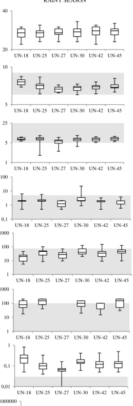
The results of the analysis of the eight water quality parameters monitored at the six basin stations during the dry and rainy periods from 2002 to 2010 are discussed below and presented in Figure 2:
● Temperature: along the Una River, the water temperature ranged from 24°C to 33°C, maintaining an average temperature of 28.1°C. It is worth noting that CONAMA Resolution nº 357/2005 (CONAMA, 2005) does not specify any temperature limits for the framework classes, but, for Amorim et al. (2017), high temperatures do decrease the solubility of gases, reducing the DO concentration.
● Potential Hydrogen (pH): despite the presence of industrial areas in the basin’s municipalities, the pH values remained unchanged. The mean values found ranged from 6.0 to 9.0 at all monitoring stations, falling within the limit allowed by CONAMA Resolution nº 357/2005 (CONAMA, 2005). Although its values were still found to conform to limits, it was observed that the pH at station UN-18 varied little due to the low flow of the river along this section. Other UN-25, UN-30 and UN-42 stations presented lower mean pH values in the rainy season (25: 7.00, 30: 6.30, UN-42: 6.70) when compared to the dry period (UN-25: 7.10; UN-30: 6.85; UN-UN-42: 6.95), corroborating with the results obtained by Piratoba et al. (2017). According to the author, this situation can be attributed both to natural factors (with increasing rainfall, the pH tends to rise, since dilution of dissolved compounds increases and there is a greater flow) for anthropogenic factors (through the launch of domestic and industrial sewage affecting the pH).
● Dissolved Oxygen (DO): the highest variation in DO was found to be concentrated at
stations UN-30 (dry season) and UN-25 (rainy season) with intervals of 0 to 6.80 mg L-1 and 1.80 to 9.10 mg L-1, respectively. These large fluctuations in DO
concentration in Una River waters were also observed by Melo et al. (2018), identifying variations from 0.9 to 9.5 mg L-1. Because of these large fluctuations, the monitored DO values (for all seasons) were at some point outside of the limit recommended in
CONAMA Resolution nº 357/2005 (CONAMA, 2005) for Class 2, which is 5 mg L-1. This fact can be associated with the intense urban occupation along the banks
Rev. Ambient. Água vol. 13 n. 6, e2251 - Taubaté 2018 ● Biochemical Oxygen Demand (BOD): at stations UN-18, UN-25 and UN-30, the BOD
parameter was observed to be higher than the limit established by the current environmental legislation (Class 2 5 mg L-1 O2) at sometimes. For example, during the dry season, a maximum of 25 mg L-1 was recorded, while during the rainy season, BOD values above 20 mg L-1 were found. The increase in the BOD values indicates an increase in the concentration of organic matter in the river, suggesting the increase of the potential for pollution. On the other hand, when the analysis is done using average values, they were found to be in compliance with the limit established for Class 2. According to Cetesb (2006), waters with BOD of less than 4 mg L-1 are classified as clean waters, and waters with BOD values above 10 mg L-1, as polluted. From this criterion, also used by Amorim et al. (2017), and considering only the mean values monitored for BOD at all stations, the Una river waters were considered clean during the analyzed period.
● Color: federal environmental legislation indicates the natural true color level for a water body has a maximum limit of 75 mg L-1 Pt for fresh water. After analyzing the data, it was found that during the dry period, only the UN-30 station had maximum values above the recommended limit. During the rainy season, the recommended maximum level was exceeded by stations UN-30, UN-42, and UN-45. In average terms, this parameter presented values that were within the limit established by legislation.
● Turbidity: the average turbidity levels were within the maximum limit established by CONAMA Resolution nº 357/2005 (CONAMA, 2005), 100 UNT, considering both dry and rainy seasons. During the dry season, only station UN-18 presented values above that foreseen by legislation, with peaks of 250 UNT. It was found that the greatest variations in turbidity are related to the presence of suspended materials during the rainy season. It was verified that the higher variations of this parameter are related to the presence of suspended materials during the rainy season, since the surface runoff has a direct relation of influence with the turbidity, according to Costa Filho et al. (2017). In addition, domestic sewage and various industrial effluents can also cause water turbidities to rise.
● Phosphorus: the phosphorus concentrations ranged from 0.01 to 0.81 mg L-1 in the rainy season and from 0.02 to 1.48 mg L-1 in the dry season. At all monitoring stations, these values are above the limit established by CONAMA Resolution nº 357/2005 (CONAMA, 2005), when evaluated for Classes 1 and 2. This situation was also observed by Melo et al. (2018) when the water quality was evaluated in regions close to the four reservoirs (currently under construction) located in the perennial stretch of the Una river, from March/2014 to April/2015. These results demonstrate the high level of contribution of nutrients resulting from the fertirrigation practices of sugarcane, and from effluent release by municipalities, which may cause problems such as eutrophication and toxic algal blooms.
Rev. Ambient. Água vol. 13 n. 6, e2251 - Taubaté 2018
DRY SEASON RAINY SEASON
Te mp er at ur e (°C ) pH D O ( mg L -1) B O D ( mg L -1) C ol or ( m g L
-1 P
t) Tu rb id ity ( U N T) Ph os ph or us (m g L -1) Th er m ot ol er an t c . (N M P 10 0 m l -1)
CONAMA Limits 357/2005 (Class 2) Figure 2. Graphical analysis of water quality parameters.
20 40
UN-18 UN-25 UN-27 UN-30 UN-42 UN-45
20 40
UN-18 UN-25 UN-27 UN-30 UN-42 UN-45
5 10
UN-18 UN-25 UN-27 UN-30 UN-42 UN-45 5 10
UN-18 UN-25 UN-27 UN-30 UN-42 UN-45
1 5 25
UN-18 UN-25 UN-27 UN-30 UN-42 UN-45 1 5 25
UN-18 UN-25 UN-27 UN-30 UN-42 UN-45
0,1 1 10 100
UN-18 UN-25 UN-27 UN-30 UN-42 UN-45 0,1 1 10 100
UN-18 UN-25 UN-27 UN-30 UN-42 UN-45
1 10 100 1000
UN-18 UN-25 UN-27 UN-30 UN-42 UN-45 1 10 100 1000
UN-18 UN-25 UN-27 UN-30 UN-42 UN-45
1 10 100 1000
UN-18 UN-25 UN-27 UN-30 UN-42 UN-45
1 10 100 1000
UN-18 UN-25 UN-27 UN-30 UN-42 UN-45
0,01 0,1 1 10
UN-18 UN-25 UN-27 UN-30 UN-42 UN-45
0,01 0,1 1
UN-18 UN-25 UN-27 UN-30 UN-42 UN-45
10 100 1000 10000 100000 1000000
UN-18 UN-25 UN-27 UN-30 UN-42 UN-45
10 100 1000 10000 100000 1000000
Rev. Ambient. Água vol. 13 n. 6, e2251 - Taubaté 2018
3.2. Simulation of DO and BOD parameters on a perennial section of the Una River
The manual calibration of the QUAL-UFMG model resulted in a satisfactory adjustment between the estimated and observed DO and BOD values. The Nash-Sutcliffe coefficients (R2) for both parameters were calculated at 0.998 and 0.999, respectively. This means that the model was able to represent 99.8% and 99.9% of the variance in the experimental DO and BOD data. During the validation of the model, performed only for the dry season between the years 2011 and 2014, it was observed that the simulated parameters (DO and BOD) were representative when compared to the observed data (𝑅𝐷𝑂2 = 0.709 and 𝑅𝐵𝑂𝐷2 = 0.779).
The results of the simulation showed that the Una River has a high dilution capacity, since the modeled section, even in the dry season, had a high flow rate. It was also observed that, during the period from 2002 to 2010, the simulations of both DO and BOD along the section modeled were within the CONAMA Resolution nº 357/2005 (CONAMA, 2005) Class 2, 100% and 99.5%, respectively (Figure 3a). In the period from 2011 to 2014, the simulated DO and BOD parameters met the limits of the above-mentioned resolution for Class 2 for 100% of the modeled section (Figure 3b). This result does not invalidate the need to install sanitary sewage systems for the municipalities within the basin (with an efficiency greater than 90%), since they do not have adequate systems to treat effluents and as population grows, increased organic load could lead to public health problems. Figure 3 shows the simulation of the DO and BOD parameters, based on the calibration and validation of the model.
(a) (b)
CONAMA 357/2005 Limits (Class 2) Observed values Estimated values
Figure 3. (a) Calibration of the DO and BOD parameters for the period from 2002 to 2010. (b) Validation of the DO and BOD parameters for the dry season from 2011 to 2014.
3.3. Presentation of the preliminary framework proposal
Based on the results obtained from the water quality analysis, mathematical modeling, and knowledge of current water use in the basin, Figure 4 represents the proposal established for the Una River framework. In this preliminary proposal, the proposed framework classes and the multiple predominant water use along four stretches of the river are identified, namely:
0 5 10
0 20 40 60 80 100 120
DO ( m g L -1) Distance (km) 0 5 10
0 20 40 60 80 100 120
DO ( m g L -1) Distance (km) 0 5 10
0 20 40 60 80 100 120
B OD ( m g L -1) Distance (km) 0 5 10
0 20 40 60 80 100 120
Rev. Ambient. Água vol. 13 n. 6, e2251 - Taubaté 2018
Figure 4. Identification of the sections framed by intended use class.
● Section 1 (Source until São Bento do Una): most of this section passes through rural areas, without the presence of industry or activities of great size. Thus, when water is present along this stretch, the local population will draw it from the river for human consumption, in addition to using it for domestic activities such as washing clothes, and recreation. Therefore, the current practices justify the proposed Class 1 framework. On the other hand, this section is also characterized by diffuse pollution, which compromises water quality to a lesser extent (presenting parameters consistent with Class 2), because it is intermittent during most of the year. The predominant uses are: human and animal water supply; irrigation of fruits and vegetables consumed raw that grow along the ground; and recreation.
● Section 2 (São Bento do Una until the vicinity of Batateiras): the analysis of the monitored water quality data suggested that this section be classified as Class 2, establishing the prevailing uses already being practiced along this section. A large volume of untreated domestic effluent from the municipalities upstream of the district of Batateiras was identified throughout this section. The prevailing uses are: human, animal and industrial water supply; and irrigation of sugarcane crops.
● Section 3 (Vicinity of Batateiras until Palmares): in this section, the Una River receives flow from other tributaries, which improves its capacity to self-purify the organic matter, even during the dry season, as shown by the results of the OD and BOD parameter modeling. Although such parameters are within the limits of Class 2, this section was classified as Class 1, demanding more severe standards of water quality, since the greater use of water in this section is destined to agriculture. In this case, the preponderant intended uses are: human and animal water supply; and irrigation of fruits and vegetables consumed raw that grow along the ground.
Rev. Ambient. Água vol. 13 n. 6, e2251 - Taubaté 2018
4. CONCLUSIONS
The water quality analyses showed that, in average terms, most of the parameters monitored during the dry and rainy seasons are within the limits established by CONAMA Resolution nº 357/2005 (CONAMA, 2005), for Class 2. Only the parameters of phosphorus and thermotolerant coliforms are outside the standards recommended by the aforementioned legislation, a fact mainly associated with the release of domestic, industrial, and public slaughterhouse effluents from urban areas along the river shore.
In spite of this, the water quality modeling showed that the Una River has a high self-purification capacity along its perennial stretch, even during the dry season, considered to be the most critical. This result is justified by the fact that the Una River basin is located in an area with high rainfall, characteristic of the southern part of the State of Pernambuco.
This hydraulic and hydrological condition of the basin made it possible to classify some stretches of the Una River as Class 1, establishing prevailing uses with more strict water quality standards, even when somewhat distant from the current practices. To this end, a framework implementation program should be established, whereby the intermediate progressive goals of water quality improvement can be defined. In the case of the Una River, it is extremely necessary to control the sources of water pollution, through adaptation to the release standards for industrial effluents and the implementation of sewage systems for the municipalities along the river.
With this proposal, the Una River will have a set of monitoring parameters that will serve as a reference for achieving and maintaining the required water quality, in order to ensure water quality compatible with its intended uses.
5. REFERENCES
AGÊNCIA ESTADUAL DE MEIO AMBIENTE E RECURSOS HÍDRICOS – CPRH (PE).
Resultados do monitoramento das bacias. Available at: http://www.cprh.pe.gov.br. Access on: 17 Feb. 2018.
AMORIM, D. G.; CAVALCANTE, P. R. S.; SOARES, L. S.; AMORIM, P. E. C. Enquadramento e avaliação do índice de qualidade da água dos igarapés Rabo de Porco e Precuá, localizados na área da Refinaria Premium I, município de Bacabeira (MA).
Engenharia Sanitária e Ambiental, v. 22, n. 2, p. 251-259, 2017. http://dx.doi.org/10.1590/S1413-41522016131212
ARAUJO, A. F. Modelagem matemática da qualidade da água como suporte ao enquadramento de corpos de água: o caso do Rio Sirinhaém – PE. 2013. 94f. Dissertação (Mestrado em Tecnologia Ambiental) - Instituto de Tecnologia de Pernambuco, Recife, 2013.
BRASIL. Presidência da República. Casa Civil. Lei Federal nº 9.433, de 8 de janeiro de 1997. Institui a Política Nacional de Recursos Hídricos e cria o Sistema Nacional de Gerenciamento de Recursos Hídricos. Diário Oficial [da] União, Brasília, DF, 8 jan. 1997.
COLLISCHONN, W.; TASSI, R. Introduzindo a hidrologia. Porto Alegre: IPH/URGS, 2010. 151 p.
Rev. Ambient. Água vol. 13 n. 6, e2251 - Taubaté 2018
CONSELHO NACIONAL DE RECURSOS HÍDRICOS (Brasil). Resolução n° 91, de 5 de novembro de 2008. Dispõe sobre procedimentos gerais para o enquadramento dos corpos de água superficiais e subterrâneos. Diário Oficial [da] União, Brasília, DF, 5 nov. 2008. CONSELHO NACIONAL DO MEIO AMBIENTE (Brasil). Resolução nº 357, de 17 de março de 2005. Dispõe sobre a classificação dos corpos de água e diretrizes ambientais para o seu enquadramento, bem como estabelece as condições e padrões de lançamento de efluentes, e dá outras providências. Diário Oficial [da] União, Brasília, DF, 17 mar. 2005.
COSTA FILHO, E.; CRUZ, K. K. T.; GOMES, M. M. A. Estudo sobre a influência do escoamento superficial no parâmetro de turbidez na bacia hidrográfica do rio Pirapama, Pernambuco, Brasil. In: ENCONTRO INTERNACIONAL DAS ÁGUAS, 9., Recife, 2017. Trabalhos… Recife: Unicap, 2017.
FAN, C.; WANG, W.; LIU, K. F.; YANG, T. Sensitivity Analysis and Water Quality Modeling of a Tidal River Using a Modified Streeter–Phelps Equation with HEC-RAS-Calculated Hydraulic Characteristics. Environmental Modeling & Assessment, v. 17, n. 1, p. 639-651, 2012. https://doi.org/10.1007/s10666-012-9316-4
GOMES, F. C.; SIMÕES, S. J. C. Simulação de modelagem qualitativa para avaliação preliminar da qualidade da água na bacia do Ribeirão das Perdizes em Campos do Jordão/SP, como subsídio ao enquadramento. Revista Brasileira de Recursos Hídricos, v. 19, n. 3, p. 309-326, 2014.
LIMA, E. E. S. Modelagem matemática da qualidade da água como suporte ao enquadramento da bacia do rio Una – PE. 2016. 108f. Dissertação (Mestrado em Tecnologia Ambiental) - Instituto de Tecnologia de Pernambuco, Recife, 2016.
LOUZADA VALORY, J. P.; REIS, J. A. T.; MENDONÇA, A. S. F. Combining genetic algorithms with a water quality model to determine efficiencies of sewage treatment systems in watersheds. Journal of Environmental Engineering, v. 142, p. 04015080, 2016. https://doi.org/10.1061/(ASCE)EE.1943-7870.0001048
MELO, D. F. B. C.; RIBEIRO, M. H. G.; ALBUQUERQUE JUNIOR, E. C.; GONÇALVES, E. A. P. Avaliação da bacia do rio Una-Pernambuco: perspectiva da qualidade da água após a construção de 4 barragens para contenção de cheias. Revista Brasileira de Geografia Física, v. 11, n. 2, p. 612-627, 2018. https://doi.org/10.26848/rbgf.v11.2.p612-627
PERNAMBUCO. Lei Estadual n° 12.984, de 30 de dezembro de 2005. Dispõe sobre a Política Estadual de Recursos Hídricos e o Sistema Integrado de Gerenciamento de Recursos Hídricos, e dá outras providências. Diário Oficial [do] Estado de Pernambuco, Recife 30 dez. 2005.
PINHEIRO, R. B.; MONTENEGRO, S. M. G. L.; SILVA, S. R.; MEDEIROS, Y. D. P.; AURELIANO, J. T. Outorga para Lançamento de Efluentes - Uma Metodologia de Apoio à Gestão de Recursos Hídricos. Revista Brasileira de Recursos Hídricos, v. 18, n. 4, p. 55-65, 2013.
Rev. Ambient. Água vol. 13 n. 6, e2251 - Taubaté 2018 SILVA, M. C. A. A. Modelagem matemática da qualidade da água como suporte ao
enquadramento da bacia do rio Goiana – PE. 2015. 109f. Dissertação (Mestrado em Tecnologia Ambiental) - Instituto de Tecnologia de Pernambuco, Recife, 2015.
SILVA, M. A. P. M.; FARIA, S. D.; MOURA, P. M. Modelagem da qualidade da água na bacia hidrográfica do Rio Piracicaba (MG). Engenharia Sanitária e Ambiental, v. 22, n. 1, p. 133-143, 2017.