Air Object Height Estimation with 2-D Radars
using Fuzzy Logic
SGK Murthy
, MV Ramana Murthy ,D Satya Narayana
Abstract- Multi sensor tracking is widely used technique
in aerospace applications to estimate the target kinematics precisely. Particularly naval-based tracking systems utilize, different types of Radars (2-D, 3-D) in multi sensor tracking scenario for robust estimation. As the supplied information from 2-D Radar contains only range and azimuth values, it is difficult to estimate the height of an air object using 2-D Radar. In order to over come the limitation, a geometric method is considered to combine the information obtained from two 2-D Radars located in two different locations. As the solution of the geometric method depends upon certain geometric features, it is not possible to get good results with one pair of sensors. However to obtain better results, a method is proposed and experimented with more than two 2-D Radars that combined with a fuzzy logic based validation. This paper discusses the issues related to 2-D Radar tracking and the method comprising Triangulation geometry and fuzzy logic based validation method to improve the height estimation accuracy in real time.
Index Terms: Fuzzy Decision making, Fuzzy Logic,
Target Tracking with 2-D Radars
I. Introduction
The development of Radar Technology started in early decades of 20th century during Second World War. All the forces used Radars to control over skies and seas. The Radar technology developed in that era is still used to track air and land objects. Target tracking is an important area of research that embraces large domain of defence as well as commercial applications[1]. Understanding air situation is an essential task for air space control. Multi Radar Tracking (MRT) is extensively used technique for naval-based target tracking applications. In multi sensor data fusion systems the Information obtained from multiple Radars located in different places are fused to
Manuscript received May 20,2010
SGK Murthy is with the Defence Research and Development Laboratory,Hyderabad,INDIA,Phone:91-40-24151654,e-mail:
MV Ramana Murthy is with the Department of Mathematics,Osmania university, Hyderabad ,INDIA,e-mail:[email protected]
D Satya Narayana is with the Department of Mathematics,Osmania University, Hyderabad,INDIA
get robust estimate[7][8]. Different types of Radars comprising 2-D, 3-D are utilized in the MRT process to estimate the target positions in 3-D. Particularly 2-D Radars, provide range and azimuth information of a target are used for ship based tracking. As the supplied plot data from 2-D Radar contains only range and azimuth information, it is not possible to estimate target height with a single sensor due to observability problem, so that there is a need to combine the information considering two or more sources of 2-D Radars separated geographically.
Fig 1:- Tracking 3-D object with 2-D Radars.
Accuracy of geometric solution is degraded when the range is far. Gai-Ming-jiu et al [2] and Hakl et al [10], provided a solution for tracking 3-D Targets with single 2-D Radar, but this solution works in some specialized conditions only. However, it is observed that the accuracy of the geometric solution is a function of three parameters i.e. angle making the Radars with the target and slant ranges from the Radar standpoints. In order to obtain optimal geometric solution, it is proposed to deploy more than two 2-D Radars located in different locations and selecting a pair of Radars, which produces good results is computed using fuzzy logic. The remainder of the paper is arranged as follows. In Section II, Geometric solution of the Radars be described. In section III, fuzzy logic and its application to the present problem is introduced. In Section IV, combined method is proposed. Section V discusses simulation results, In Section VI future work is proposed and section VII draws conclusions.
II.Geometric Solution
azimuth information of the target E (R1, Az1 and R2, Az2). By using the geometric solution described in the following diagram (Fig 2), air object height is estimated. Performance of triangulation geometry is highly dependent on the accuracies of the observed measurements and geometric values.
The following diagram describes the geometry of air object tracking from two 2-D Radars located in two ships separated geographically.
Fig 2: - Geometry with 2-D Radars
By considering the Radar positions in geodetic co-ordinate frame, located at A and B, and the obtained ranges (R1, R2) and azimuths (Az1, Az2) information in the each iteration, elevation angle with respect to the each Radar located at A and B are computed. The elevation angle obtained with the 2nd Radar that is angle CBE is converted with respect to the Radar1 position. In turn this value is combined with angle
CAE (obtained with Radar1) to compute the mean elevation. The following algorithm explains process in detail for a single iteration.Step1 - Compute the distance between Radar stand points A and B.
Step2 - Compute the angles BAC and ABC using the observed azimuth values Az1 and Az2.
Step3 - Compute the angle ACB =
– ABC – BAC.Step4 - Compute the side lengths BC and AC using trigonometric equations and the computed values in above steps.
Step5 - Using BC and AC compute the target elevation EL1 and EL2 with respect to Radar1 and Radar2.
Step6 - Converting the two polar co-ordinates (range, azimuth, elevation) with respect to a point of interest either (Radar1 or Radar2 stand point) and average the elevation value.
Using elevation value obtained from the step6 and existing range and azimuth values, air object height is estimated in ENV( East , North, Vertical) Frame.
III. Fuzzy Logic
In 2-D Radar tracking, multiple 2-D Radars track the 3-D targets from the ships and it is observed that certain target geometric values are affecting the accuracy of the solution. Fuzzy validation method is considered, to obtain the pair of 2-D Radars, which gives optimal accuracy.
Fuzzy logic is an extension of Boolean logic supports in between values between true and false. The concept of fuzzy logic was introduced by Professor Lotfi A. Zadeah[5] . The goal was to develop a model that could be more close to natural language process.
3.1. Fuzzification
Fuzzification is the first step in a fuzzy system. In this process all crisp inputs are converted into fuzzy variables. Fuzzification process partitions the universe of discourse spanned by each variable into a number of fuzzy sets, assigning a linguistic variable[6]. Fuzzy sets are represented by fuzzy membership functions (MF). Different types of membership functions can be used for fuzzification process.
3.1.1. Membership function
In fuzzy systems fuzzy sets are represented by fuzzy membership functions (MF). Triangular, Trapezoidal, Gaussian, are some of the membership functions[5] , used as per the convenience and nature of the problem. The following diagram (Fig 3) describes the considered membership functions for the fuzzification process of input “ angle” for the present problem.
For every crisp value, membership functions represent a degree, which indicates the strength of its concern to the fuzzy set. The degree of membership is always in the range [0,1]. For example any crisp value has a membership degree (or degree of support) 0, indicates that the value is not in the fuzzy set. If the degree is 1, means, the value is completely with in the fuzzy set. The following equations explain, how to calculate a membership value (m (x)) for a crisp value x, by using triangular membership function.
Where a1, a2 and a3 are the x co-ordinates of the start, middle end points of a triangular fuzzy membership function.
3.2. Fuzzy Inference
Fuzzy inference is a process of formulating a mapping from inputs to output using fuzzy logic. In fuzzy inference, knowledge is expressed in terms of fuzzy if then rules. The computation of fuzzy inference consists two components Aggregation (computation of if part) and Composition (computation of then part). The most common inference methods AND, OR and NOT are used in majority of fuzzy logic applications.
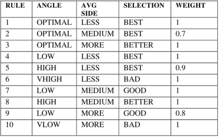
In case, a numerical output is required from the inference process, a defuzzification step must follow the fuzzy inference. For the present study , Mamdani type fuzzy inference is considered. A weight factor is used to tune the fuzzy logic system for optimal performance, the weight factor represents the strength of the rule belongs to the interval [0,1]. It is multiplied with the aggregation result in the composition step. The following table ( Table 1 ) describes, some of the fuzzy rules considered for the present problem.
Table 1:- Fuzzy inference (Rules) considered for the present problem
RULE ANGLE AVG SIDE
SELECTION WEIGHT
1 OPTIMAL LESS BEST 1 2 OPTIMAL MEDIUM BEST 0.7 3 OPTIMAL MORE BETTER 1 4 LOW LESS BEST 1 5 HIGH LESS BEST 0.9
6 VHIGH LESS BAD 1
7 LOW MEDIUM GOOD 1
8 HIGH MEDIUM BETTER 1
9 LOW MORE GOOD 0.8
10 VLOW MORE BAD 1
3.3. Defuzzification
Defuzzification process translates fuzzy values to crisp value. Most of the fuzzy systems required this process to visualize the result in a numerical form rather than fuzzy. Defuzzification step also requires membership functions as shown in Fig 4. The following equation represents computation of crisp value U using proposed center of area defuzzification method for the present problem. Defuzzification method computes a crisp value U, which is in range of [0, 100].
1 1
(
*
) /
n n
i i i
i i
U
A
L
A
Where Ai represents area covered under each fuzzy set
and Lirepresents mid point of the fuzzy set on x- axis and
n = 5 ( number of fuzzy sets in the defuzzification process).
IV. Combination of the Methods
In order to obtain optimal results, it is considered more than two 2-D Radars deployed in different ships, which are separated geographically. Each 2-D Radar deployed in the ship tracks the air object, if the air object is within the coverage area. So that for a particular air object , tracked Radar supplies range and azimuth information. For estimating air object height, there is a need to process the received information by considering geometric solution mentioned in Section II. During the experiment phase, it is observed that angles and the slant ranges play a critical role in height estimation process and identifying best pair based on the angles and slant ranges is hard part with conventional approach. It is well known that fuzzy systems perform well in non-linear dynamic systems [9], where mathematical models are complex. In order to get optimal accuracy, Fuzzy logic based validation is considered for the selection of optimal pair from the available pairs. For the present study, three 2-D Radars are considered for tracking the target, so that three data sets i.e. T1, R1, Az1 (Time,Range, Azimuth) from Radar1 T2, R2, Az2, from Radar2 and T3, R3, Az3 from Radar3 are obtained for the process in each process. The following flow chart (Fig 5 ) describes the entire the process for each iteration.
Fig 5 :- Proposed method to estimate air object height with 2-D Radars using fuzzy logic
V. Simulation & Results
Using the above-mentioned method, software is developed using MATLAB. In order to test the software, ballistic and aircraft trajectories are simulated by considering target dynamics. In this experimental study target ship motion also considered. Software is tested with different data sets obtained from the simulation models and the results are shown in MATLAB graphs. In order to compare the performance (Pimp) of the proposed method,
the following equation is used.
n n
f i= 1 i= 1 im p
n i= 1
1 1
|H p |- |H |
n n
P
1
|H p | n
Where HP represents error in height computed by one pair
of Radars and Hf represents the error in height, of optimal
pair, obtained by fuzzy validation method. The following table (Table 2) describes % of benefit of optimal pair over available pairs (1-2,1-3,2-3) of trajectories tested with the software.
Considering two different types of targets i.e. ballistic and aerodynamic, software is tested with different dynamics . In experiment 1, a simulated ballistic trajectory with the range 100 km launched with the azimuth 450 and reaches the maximum height 50 km, is given as input. Height estimation errors are shown as Fig 6, Fig 7 and Fig 8. In experiment 2, aircraft trajectory is simulated with the initial height 3 km. % of benefit by fuzzy validation method with respect to available pairs is given in the following table ( Table 2).
Table 2:- % of benefit by fuzzy validation method with respect to available pairs
Type 1-2 Pair 1-3 Pair 2-3 pair
Ballistic 57.53% 57.5% 48.97%
Fig 6: - Ballistic target height estimation errors of PAIR 1-2 and Fuzzy Selection
Fig 7: - Ballistic target height estimation errors of PAIR 1-3 and Fuzzy Selection
Fig 8: - Ballistic target height estimation errors of PAIR 2-3 and Fuzzy Selection
VI. Future work
In the present work, random errors caused by sensors are not considered. In order to control random
disturbances in measurements, statistical estimation techniques[3] (Ex Kalman Filter) are utilized frequently which require target dynamic models and sensor uncertainties. For future enhancement, Wavelets based denoising techniques in combination of statistical approaches or alone are considered, as multi resolution techniques do not require any pre assumptions.
VII. Conclusion
In this paper, a new algorithm is presented that combines a geometric solution of 2-D Radars with fuzzy logic based validation technique for improving the accuracy of air target height estimation. Based on the proposed algorithm, software is designed and developed to estimate the 3-D target height using 2-D Radar data. Software is tested with different sets of ballistic and aircraft trajectories. In this experimental study Mamdani type fuzzy logic technique is utilized to select a pair of sensors to get optimal values, among all available sensor pairs. It is observed that the proposed algorithm has significant benefits over normal 2-D tracking methods. Presently all the fuzzy rules are generated and tuned manually. In order to enhance the accuracy, it is required to use genetic, neural techniques for optimal inference rules.
References
[1]. Farid Amoozegar et al, Survey of Fuzzy logic and neural network technology for multi-Target Tracking, SPIE Vol 3371, April 1998
[2]. Gai-Ming-jiu et al, An approach to Tracking a 3-D target with 2-D Radar, Research institute of Applied Mathematics, Naval Aeronautical Engineering Institute, Yantai, P.R.China, 2005
[3]. Yaakov Bar-Shalom et al, Estimation with Applications to Tracking and Navigation, John wiley & Sons Inc, 2001
[4]. Ym Chen, Information Fusion in data association applications, Applied Soft Computing 6 (2006) 394-405, www.sciencedirect.com
[5]. L.A. Zadeh, Fuzzy Sets and Systems, North-Holland, Amsterdam, 1978
[6]. Leonid Reznik, Fuzzy Controllers, Newnes, 1997 [7]. Hall, David L, Hand Book of multi sensor data Fusion,
CRC Press, 2001
[8]. Blackman, Samuels, Design and analysis of modern tracking Systems, Artech House, Boston, 1999
[9]. Hazeem N et al, Multiscale fuzzy kalman filtering, Engineering applications of Aritificial Intelligence 19(2006) 439-450, Jan 2006