HESSD
9, 11131–11159, 2012GRACE water storage estimates for
the Middle East
L. Longuevergne et al.
Title Page
Abstract Introduction
Conclusions References
Tables Figures
◭ ◮
◭ ◮
Back Close
Full Screen / Esc
Printer-friendly Version Interactive Discussion
Discussion
P
a
per
|
Dis
cussion
P
a
per
|
Discussion
P
a
per
|
Discussio
n
P
a
per
|
Hydrol. Earth Syst. Sci. Discuss., 9, 11131–11159, 2012 www.hydrol-earth-syst-sci-discuss.net/9/11131/2012/ doi:10.5194/hessd-9-11131-2012
© Author(s) 2012. CC Attribution 3.0 License.
Hydrology and Earth System Sciences Discussions
This discussion paper is/has been under review for the journal Hydrology and Earth System Sciences (HESS). Please refer to the corresponding final paper in HESS if available.
GRACE water storage estimates for the
Middle East and other regions with
significant reservoir and lake storage
L. Longuevergne1, C. R. Wilson2, B. R. Scanlon3, and J. F. Cr ´etaux4
1
G ´eosciences Rennes, UMR6118, CNRS – Universit ´e de Rennes 1, Rennes, France
2
Department of Geological Sciences, Jackson School of Geosciences, The University of Texas at Austin, Austin, TX, USA
3
Bureau of Economic Geology, Jackson School of Geosciences, The University of Texas at Austin, Austin, TX, USA
4
LEGOS, UMR5566, CNES/CNRS/IRD – Universit ´e Paul Sabatier, Toulouse, France Received: 9 September 2012 – Accepted: 16 September 2012 – Published: 1 October 2012 Correspondence to: L. Longuevergne ([email protected])
HESSD
9, 11131–11159, 2012GRACE water storage estimates for
the Middle East
L. Longuevergne et al.
Title Page
Abstract Introduction
Conclusions References
Tables Figures
◭ ◮
◭ ◮
Back Close
Full Screen / Esc
Printer-friendly Version Interactive Discussion
Discussion
P
a
per
|
Dis
cussion
P
a
per
|
Discussion
P
a
per
|
Discussio
n
P
a
per
|
Abstract
While GRACE (Gravity Recovery and Climate Experiment) satellites are increasingly being used to monitor water storage changes globally, the impact of spatial distribution of water storage within a basin is generally ignored but may be substantial. In many basins, water may be stored in reservoirs, lakes, flooded areas, small aquifer systems,
5
and other localized regions with sizes typically below GRACE resolution. The objec-tive of this study was to assess the impact of non-uniform water storage distribution on GRACE estimates as basin-wide averages, focusing on surface water reservoirs. Analysis included numerical experiments testing the effect of mass size and position within a basin, and application to the Lower Nile (Lake Nasser) and Tigri–Euphrates
10
(TE) basins as examples. Numerical experiments show that by assuming uniform mass distribution, GRACE estimates may under- or over-estimate basin-average water stor-age by up to a factor of two, depending on reservoir location and extent. Although their spatial extent may be unresolved by GRACE, reservoir storage may dominate in some basins. For example, it accounts for 95 % of seasonal variations in the Lower
15
Nile and 10 % in the TE basins. Because reservoirs are used to mitigate droughts and buffer against climate extremes, their influence on interannual time scales can be large, for example accounting for 50 % of total water storage decline during the 2007–2009 drought in the TE basin. Effects on GRACE estimates are not easily accounted for via simple multiplicative scaling, but in many cases independent information may be
avail-20
able to improve estimates. Accurate estimation of the reservoir contribution is critical, especially when separating groundwater from GRACE total water storage changes. Be-cause the influence of spatially concentrated water storage – and more generally water distribution – is significant, GRACE estimates will be improved when it is possible to combine independent spatial distribution information with GRACE observations, even
25
HESSD
9, 11131–11159, 2012GRACE water storage estimates for
the Middle East
L. Longuevergne et al.
Title Page
Abstract Introduction
Conclusions References
Tables Figures
◭ ◮
◭ ◮
Back Close
Full Screen / Esc
Printer-friendly Version Interactive Discussion
Discussion
P
a
per
|
Dis
cussion
P
a
per
|
Discussion
P
a
per
|
Discussio
n
P
a
per
|
1 Introduction
Large rivers cross the Middle East and bring life to these dry regions, where throughout human history reservoirs have served to ensure an adequate water supply by storing water in times of surplus and releasing it in times of scarcity (Altinbilek, 2002), provid-ing a buffer to mitigate seasonal and interannual variability of precipitation. Regulation
5
to ensure water supply and control floods may become even more critical in the fu-ture with increasing intensity of the hydrologic cycle (Easterling et al., 2000). Initially, only small dams were built for water supply and for irrigation, but today half the world’s large dams were built exclusively or primarily for irrigation and an estimated 30–40 % of irrigated lands rely on reservoirs (WCD, 2000). The last century experienced a rapid
10
increase in large-dam building, from ∼5000 large dams by 1950 globally, mostly in
industrialized countries, to ∼45 000 by the end of the 20th century in ∼150
coun-tries. About 50 % of the dams were built mainly for irrigation purposes, mostly in India (World Bank, 1998). Water inflows to reservoirs are mostly controlled mainly by pre-cipitation and water convergence from contributing basins, while outflows are subject
15
to laws and policies serving agricultural, industrial, and urban needs, in addition to physical processes of seepage and evaporation. Most reservoirs are above ground; but below-ground reservoirs (groundwater banks), with up to∼1 km3 storage are now
being developed in the Central Valley of California, and are in service elsewhere. Reservoirs can also have large scale impacts on water sharing among countries.
20
For example, in the Tigris–Euphrates basin, population growth and associated higher reliance on irrigated agriculture highlights water sharing issues among upstream (Turkey) and downstream (Syria and Iraq) users and is causing strong rivalries in this transboundary watershed. Continued development of hydraulic resources in upstream Tigris–Euphrates also leads to higher sensitivity to droughts and lower water quality
25
HESSD
9, 11131–11159, 2012GRACE water storage estimates for
the Middle East
L. Longuevergne et al.
Title Page
Abstract Introduction
Conclusions References
Tables Figures
◭ ◮
◭ ◮
Back Close
Full Screen / Esc
Printer-friendly Version Interactive Discussion
Discussion
P
a
per
|
Dis
cussion
P
a
per
|
Discussion
P
a
per
|
Discussio
n
P
a
per
|
ground-based data, GRACE satellite data may be very valuable for monitoring water storage changes. Accurate GRACE water storage estimates have importance beyond practical hydrology, given the politics and conflicts associated with drought and trans-boundary water allocation and management among Turkey, Syria, and Iraq. Accurate assessment of total water storage and its variations within a basin thus requires careful
5
attention to the reservoir component.
GRACE satellites are unique in their ability to monitor changes in total water stor-age (∆TWS), a combination of changes in ice+snow water equivalent (∆SWES), surface water (∆SWS), soil moisture (∆SMS) and groundwater storage (∆GWS) (Ta-pley et al., 2004; G ¨untner, 2008; Schmidt et al., 2008). Extracting individual
con-10
tributions from individual storage compartments requires solving the disaggregation equation, and often the objective is an estimate of groundwater storage changes
∆GWS= ∆TWS−∆SWES−∆SWS−∆SMS. In this process, surface water is often
ne-glected (e.g. Frappart et al., 2011; Shamsudduha et al., 2012), but should be estimated properly to avoid accumulating errors. One difficulty is that surface water storage
vari-15
ations are often concentrated in small areas, such as lakes, rivers, and flooded areas. A related problem is that storage is often within artificial reservoirs (∆RES) under an-thropic control, and is therefore frequently omitted from physically-based Land Surface Models (LSM’s).
The spatial resolution of GRACE data is typically given as a few hundred km, but
20
GRACE is actually sensitive to total water storage variation, including storage within regions with small spatial scales if water level variations are sufficiently large. In agri-cultural regions, for example, where groundwater systems are exploited in conjunc-tion with surface water (e.g. Scanlon et al., 2012b), a separate estimate of groundwa-ter storage variations requires estimation of the surface wagroundwa-ter contribution, especially
25
HESSD
9, 11131–11159, 2012GRACE water storage estimates for
the Middle East
L. Longuevergne et al.
Title Page
Abstract Introduction
Conclusions References
Tables Figures
◭ ◮
◭ ◮
Back Close
Full Screen / Esc
Printer-friendly Version Interactive Discussion
Discussion
P
a
per
|
Dis
cussion
P
a
per
|
Discussion
P
a
per
|
Discussio
n
P
a
per
|
there is now a database available to separate groundwater and surface water uses (Siebert et al., 2010).
Virtually all artificial reservoirs are point masses at the spatial resolution of GRACE. For example, a large reservoir has a surface area of∼1000 km2 which is smaller by
about two orders of magnitude than the smallest basin (∼200 000 km2) that can be
5
usefully resolved by GRACE. However, GRACE is able to detect a 1 cm water storage change with a 200 000 km2 basin, which is comparable in mass (hence observabil-ity) to a few meters of water level change within a 1000 km2 reservoir. The capability of GRACE to monitor reservoirs was documented in a pre-launch study by Boy and Chao (2002) for the Three-Gorges reservoir, and examined subsequently by Wang
10
et al. (2011). Other GRACE studies have examined storage in the great African lakes (Swenson and Wahr, 2009; Becker et al., 2010), and the Aral Sea (Singh et al., 2012). In these, GRACE observations were supplemented with satellite radar altimetry obser-vations of water level changes.
While the contributions of surface water and reservoirs have been recognized, their
15
quantitative influence has been unclear. More precisely, it has not been clear how small scale and/or discontinuous distribution of water sources affect basin-scale average wa-ter storage variations that are typically computed from GRACE data. For example, Rodell et al. (2008) estimated groundwater depletion in Rajasthan, but applied diff er-ent multiplicative factors for rescaling seasonal variations and trends in GRACE.
Sea-20
sonal variations were attributed to soil moisture, distributed over an area larger than the aquifer, while trends were attributed to the groundwater system. More recently, Scanlon et al. (2012a) noted that the effective multiplicative (scaling) factor required to correct for spatial distribution may vary by∼15 % among storage components, due
to varied spatial distribution. For example, snow is usually concentrated within
moun-25
HESSD
9, 11131–11159, 2012GRACE water storage estimates for
the Middle East
L. Longuevergne et al.
Title Page
Abstract Introduction
Conclusions References
Tables Figures
◭ ◮
◭ ◮
Back Close
Full Screen / Esc
Printer-friendly Version Interactive Discussion
Discussion
P
a
per
|
Dis
cussion
P
a
per
|
Discussion
P
a
per
|
Discussio
n
P
a
per
|
The objective of this study is to evaluate how the spatial distribution of water affects GRACE basin-scale estimates of∆TWS. Point masses are taken as the model for the distribution of typical reservoirs. Simple parametric numerical experiments are used first to estimate the impact of reservoir location and areal extent on basin-scale av-erage water storage variations, from GRACE. Then, examples from basins with large
5
reservoir components are used to show the effect by combining independent satellite data on reservoir storage with GRACE data. The examples demonstrate the impor-tance of adding spatial distribution information to obtain accurate TWS estimates, and to disaggregate soil moisture and groundwater components.
2 Material and methods
10
2.1 Synthetic numerical experiment
The influence of spatially concentrated water storage variations on GRACE is illustrated via two simple synthetic numerical experiments. Results apply to any spatially concen-trated storage component (glaciers, rivers, small-scale groundwater system) estimated from GRACE observations, whether in Spherical Harmonic (SH), gridded (Landerer
15
and Swenson, 2012) or “mascon” (e.g. Tiwari et al., 2009; Rowland et al., 2010) form, given that spatial resolution is constrained by potential field physics to be comparable to GRACE satellites’ altitude of∼400 km. In these experiments, a simple circular basin
contains a point mass representing a 1 km3reservoir and its impact on GRACE is for-ward modeled from a 1/8th degree grid. In the first experiment, location of the point
20
HESSD
9, 11131–11159, 2012GRACE water storage estimates for
the Middle East
L. Longuevergne et al.
Title Page
Abstract Introduction
Conclusions References
Tables Figures
◭ ◮
◭ ◮
Back Close
Full Screen / Esc
Printer-friendly Version Interactive Discussion
Discussion
P
a
per
|
Dis
cussion
P
a
per
|
Discussion
P
a
per
|
Discussio
n
P
a
per
|
2.2 Tigris–Euphrates and Lower Nile basins
Results from the numerical experiments, and other data, are used to interpret GRACE water storage estimates within two basins in arid/semi-arid Middle East regions: the lower Nile and the Tigris–Euphrates basins, both with significant anthropic reservoir management. Additional examples are provided in the Supplement, including Guri Lake
5
(Orinoco Basin) Amu and Syr Darya (Aral Sea) and the East African lakes (Xie et al., 2012). Lake and reservoir volume variations were first estimated using independent radar altimetry data, in order to predict the GRACE signal. Predicted and observed wa-ter storage variations at GRACE resolutions were then compared with LSM estimates. Lake Nasser (6216 km2area) is located in the lower Nile basin at the border between
10
Egypt and Sudan (Fig. 2). The lake was filled in the 1960s to 1970s with the construc-tion of the Aswan high dam upstream of the old Aswan dam. The total capacity of the reservoir is 162 km3 at the level 182 m a.m.s.l. (Sadek et al., 1997). Lake levels may vary by up to 7 m between summer and winter, with evaporation accounting for 2.35 m (15 % of river inflow) and seepage to nearby aquifers accounting for 230 mm (1.2 % of
15
river inflow), see (Aly et al., 1993).
The Tigris–Euphrates (TE) basin has seen anthropic management for over six mil-lennia. The regional climate shows predominantly winter precipitation, with snow in surrounding mountain ranges (Jones et al., 2008). Therefore, summer crop production relies heavily on irrigation. For example, Mesopotamia (from the Greek “land between
20
two rivers”), as the cradle of modern civilization, was built upon the wealth of irrigated agriculture, and remains now as one of the most engineered basins in the world. Ir-rigation greatly expanded at the beginning of the 20th century. Both rivers originate in Turkey and construction of several dams in Turkey and Syria has greatly reduced flow into downstream Iraq. Jones et al. (2008) showed a large streamflow reduction
25
HESSD
9, 11131–11159, 2012GRACE water storage estimates for
the Middle East
L. Longuevergne et al.
Title Page
Abstract Introduction
Conclusions References
Tables Figures
◭ ◮
◭ ◮
Back Close
Full Screen / Esc
Printer-friendly Version Interactive Discussion
Discussion
P
a
per
|
Dis
cussion
P
a
per
|
Discussion
P
a
per
|
Discussio
n
P
a
per
|
the Ataturk reservoir, leading to crop loss of 15 % (Mutin, 2009). Beyond dam stor-age, water loss by evapotranspiration (lake surface, crop irrigation) and seepstor-age, also decreases streamflow and increases sensitivity of downstream reservoirs to droughts.
2.3 Reservoir data
In a few regions of the world, such as the state of California in the US, reservoir
stor-5
age information is publicly available, but more commonly such data are difficult to ob-tain. However, satellite radar altimetry estimates of reservoir water level and/or vol-ume variations are available for many large reservoirs. Several missions have been launched since the early 1990s: ERS-1 (1991–1996), T/P (1992–2005), ERS-2 (1995– 2002), GFO (2000–2008), JASON-1 (2001–cont.), JASON-2 (2008–cont.) and
EN-10
VISAT (2002–2012). The combined global altimetry historical data set now covers approximately two decades and will be continuously updated in the coming decade. Merging altimetry data from several in-orbit altimetry missions also increase the spatio-temporal resolution of the remotely-sensed hydrological variables.
We used lake and reservoir level/volume variations obtained from the Hydroweb
15
database (Cr ´etaux et al., 2005, 2011) for regions shown in Table 1. Time series of water stage, computed from satellite altimetry for 165 natural lakes and artificial reservoirs, are available on http://www.legos.obs-mip.fr/en/soa/hydrologie/hydroweb/. Estimates incorporate specific biases of each satellite (Cr ´etaux et al., 2009). The accuracy of radar altimetry over lakes is for 2–3 cm for large lakes, and up to 70–
20
80 cm for small and narrow lakes. Lake areas and volume are also provided in Hydroweb for a selection of 30 lakes worldwide. Satellite remote sensing optical imagery (mainly Landsat satellites) has been used for these purposes. At a reso-lution of about 30 m these data can be successfully used to detect the presence of water on the Earth and estimate lake surface area at different levels. A water
25
HESSD
9, 11131–11159, 2012GRACE water storage estimates for
the Middle East
L. Longuevergne et al.
Title Page
Abstract Introduction
Conclusions References
Tables Figures
◭ ◮
◭ ◮
Back Close
Full Screen / Esc
Printer-friendly Version Interactive Discussion
Discussion
P
a
per
|
Dis
cussion
P
a
per
|
Discussion
P
a
per
|
Discussio
n
P
a
per
|
assumed. Two other data centers release lake and rivers level variations: US Dept. of Agriculture (http://www.pecad.fas.usda.gov/cropexplorer/global reservoir) and Euro-pean Space Agency (http://tethys.eaprs.cse.dmu.ac.uk/RiverLake/shared/main).
2.4 Land surface models
For comparison with GRACE and reservoir data, we examine water storage estimates
5
from LSMs, which mainly describe changes in snow storage (∆SWES) and soil mois-ture storage (∆SMS) due to natural physical processes. Water storage changes in managed reservoirs are generally not included in LSMs because regulation rules are not well known. However, one LSM, WGHM (Water Gap Hydrological Model) incor-porates these variations in some basins (D ¨oll et al., 2003; Hunger and D ¨oll, 2008).
10
A version of WGHM has been calibrated jointly with GRACE and river discharge data (Werth and G ¨untner, 2010), but the version used here is independent of GRACE. Stor-age estimates are also taken from another widely used LSM, GLDAS (Global Land Data Assimilation System) (Rodell et al., 2004) which omits reservoir water storage changes. GLDAS results include four different LSMs, CLM, MOSAIC, NOAH and VIC.
15
In the following, GLDAS ∆SMS is computed as the mean water storage variations among MOSAIC, NOAH and VIC model (soil moisture+snow water equivalent). The relative importance of reservoir storage changes on TWS can be evaluated by compar-ing GLDAS∆SMS results with WGHM (which includes reservoirs). Results are com-pared with GRACE by integrating LSM grid values over Oki and Sud (1998) basins
20
available at 0.5◦resolution.
2.5 GRACE data
Two different GRACE solutions are examined. The first is based upon monthly release 04 Spherical Harmonic (SH) data from CSR (Center for Space Research), truncated at degree and order 60 (Bettadpur, 2007) including a destriping filter (Swenson and Wahr,
25
HESSD
9, 11131–11159, 2012GRACE water storage estimates for
the Middle East
L. Longuevergne et al.
Title Page
Abstract Introduction
Conclusions References
Tables Figures
◭ ◮
◭ ◮
Back Close
Full Screen / Esc
Printer-friendly Version Interactive Discussion
Discussion
P
a
per
|
Dis
cussion
P
a
per
|
Discussion
P
a
per
|
Discussio
n
P
a
per
|
from GRGS (Groupe de Recherche en G ´eod ´esie Spatiale), stabilized and truncated at 50◦(Lemoine et al., 2007; Bruinsma et al., 2010). No additional filtering is required for
GRGS solutions. In each example, basin-scale water storage variations and associated errors are calculated following procedures outlined by Longuevergne et al. (2010). The GRACE SH expansion of apparent mass change is integrated over the basin, and
5
then bias and leakage corrections are computed assuming GLDAS-NOAH correctly represents water mass variations and distribution both within and outside the basin. Bias and leakage corrections are determined separately, then added to the GRACE apparent mass change. Because GLDAS excludes reservoir storage, bias and leakage corrections are likely less accurate when reservoir is a major component of the water
10
balance.
3 Synthetic numerical experiment–analysis
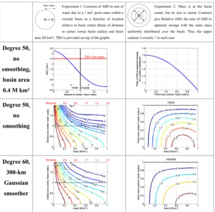
We use SH representations of surface mass change (Wahr et al., 1998), limiting de-gree and order to 50 (to simulate GRGS), and to 60 (to simulate CSR RL04, including a Gaussian 300 km filter). A hard truncation (no filtering) at 50◦ does not exactly du-15
plicate stabilization of GRGS solutions at higher degrees (Lemoine et al., 2007). We evaluate SH expansions of mass change over circular basins of varying size, and cal-culate apparent basin-wide average mass when the true mass is spatially concentrated within the basin. Apparent Basin Storage (ABS) equals the SH expansion of mass in-tegrated over the entire basin, divided by basin area. True Basin Storage (TBS) equals
20
the actual mass located within the basin divided by basin area.
The overall impact of point mass on GRACE is the sum of the effects of its location, area and GRACE processing. In the first experiment (Figs. 1, S1), the location of a point mass representing 1 km3 of water (in practice assigned to a 1/8th degree cell) was varied relative to the basin center, for basins of various sizes (Figs. 1, S1). Three main
25
HESSD
9, 11131–11159, 2012GRACE water storage estimates for
the Middle East
L. Longuevergne et al.
Title Page
Abstract Introduction
Conclusions References
Tables Figures
◭ ◮
◭ ◮
Back Close
Full Screen / Esc
Printer-friendly Version Interactive Discussion
Discussion
P
a
per
|
Dis
cussion
P
a
per
|
Discussion
P
a
per
|
Discussio
n
P
a
per
|
1. The position of a point mass strongly affects ABS. For example, a 0.4 M km2basin has TBS=2.5 mm (1 km3/0.4 M km2), but ABS (50◦) is 24 % larger (3.1 mm) when
the point mass is at the center. When located near the edge, ABS is 50 % lower (1.2 mm) than TBS. ABS diminishes quickly as the mass moves off-center due to leakage to regions outside the basin.
5
2. Basin area influences the magnitude of the point mass effect. A 0.2 M km2basin where TBS=5 mm but ABS is always less than this (for 50◦), with ABS
=4.1 mm when at the basin center and 2.5 mm at the basin edge. Masses outside the basin yield a similar ABS to point masses inside the basin, when the basin is small (area
<300 000 km2). 10
3. ABS is strongly affected by smoothing. The degree 60 case yields ABS that is bi-ased as smoothing spreads the signal over a large area, decreasing ABS relative to the 50◦
case.
In the second experiment (Figs. 1, S2), the mass is centered within the basin but its radius is varied from a point (in practice 1/8 degree) up to the basin radius. The results
15
are described by Relative ABS, the ratio of ABS divided by its value when mass radius equals basin radius (equivalent to assuming a uniform distribution for storage). More concentrated masses increase relative ABS, as much as 60 % (multiplicative factor of 1.6) because leakage to regions outside the basin is diminished with greater concen-tration. Hard-truncation negative sidelobes in the 50◦ case cause diminished Relative 20
ABS for larger basins.
These two experiments can be used to interpret GRACE estimates for any basin with a spatially irregular water storage distribution. A first point is that ABS from GRACE is rarely equal to TBS and may be smaller or larger, depending upon the position of the mass and its areal extent. Masses outside a basin may contribute significantly as well
25
HESSD
9, 11131–11159, 2012GRACE water storage estimates for
the Middle East
L. Longuevergne et al.
Title Page
Abstract Introduction
Conclusions References
Tables Figures
◭ ◮
◭ ◮
Back Close
Full Screen / Esc
Printer-friendly Version Interactive Discussion
Discussion
P
a
per
|
Dis
cussion
P
a
per
|
Discussion
P
a
per
|
Discussio
n
P
a
per
|
close to the center). When no smoothing is applied, ABS will be close to TBS when the reservoir is located half way to basin edge and has a small area. When smoothing is applied, ABS is always smaller than TBS. As the reservoir moves towards the basin margin, the effects of location and spatial extent partially cancel one another.
4 Application to GRACE and RES observations
5
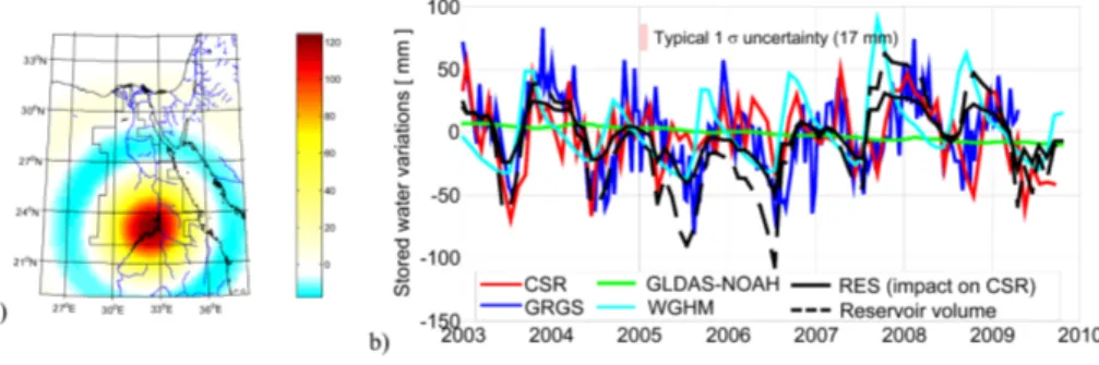
4.1 Lower Nile and Lake Nasser
The impact of anthropic water management is evident from differences between GLDAS ∆SMS (which does not include Lake Nasser storage changes) and WGHM (incorporating Lake Nasser regulation rules) over the Lower Nile basin (Fig. 2). The dif-ference is∼40 mm for seasonal variations. GRACE estimates clearly capture changes 10
in Lake Nasser, though some differences in phase are evident during Fall of 2007 and 2008. Estimates of Lake Nasser storage changes from GRACE shown in Fig. 2 can be understood using experiment 1. If the mass is assumed uniformly distributed over the Lower Nile basin then estimated storage is twice that actually determined from GRACE, as expected from experiment 1. A consequence is that long-term variations
15
will be greatly overestimated. While the area of Lake Nasser constitutes only 1.5 % of the Lower Nile basin, it accounts for∼95 % of the water storage changes.
The Lower Nile basin is also important because the region evaluated in this study covers ∼30 % of the Nubian Aquifer System (NAS). There is interest in applying
GRACE to evaluate groundwater storage changes in the NAS. The NAS extends over
20
more than 2 M km2and is one of the largest groundwater system in the world shared by Egypt, Lybia, Sudan and Chad (Sultan et al., 1997; Gossel et al., 2008). It is the only major fresh water resource in the Eastern Sahara besides the River Nile. In this arid area, recharge from rainfall is limited to a couple of mm a year. Water stored within this aquifer is mostly fossil nonrenewable groundwater accumulated during the Quaternary
25
HESSD
9, 11131–11159, 2012GRACE water storage estimates for
the Middle East
L. Longuevergne et al.
Title Page
Abstract Introduction
Conclusions References
Tables Figures
◭ ◮
◭ ◮
Back Close
Full Screen / Esc
Printer-friendly Version Interactive Discussion
Discussion
P
a
per
|
Dis
cussion
P
a
per
|
Discussion
P
a
per
|
Discussio
n
P
a
per
|
is now being mined in several areas, mainly in oases spread over Egypt and Libya, west of the Nile valley, with pumping rates reaching 10 times natural discharge (Gossel et al., 2008).
Application of GRACE data in this region to estimate groundwater storage variations is subject to careful consideration of: (1) the impact of surface water, from reservoirs,
5
but also long-term storage variations from temporary lakes located further west in the Tushka depression. These lakes are created by unusual water rise in Lake Nasser in-duced by high precipitation in the Ethiopian Highlands (Abdelsalam et al., 2008). During the last wet period, these lakes covered an area of 1586 km2. Recharge of the Nubian aquifer by these intermittent lakes is insignificant as they are underlain by impermeable
10
shale and chalk formations; (2) the complex nature of the aquifer system. NAS is con-fined over most of the northern half of the aquifer, where most of pumping stations are located, but also overlain by the unconfined post-Nubian aquifer system; (3) GRACE itself. While signal amplitude is limited in this region (note high noise amplitude on Fig. 2b), there might be potential leakage from high amplitude water storage variations
15
farther south in the recharge area.
4.2 Tigris–Euphrates basin
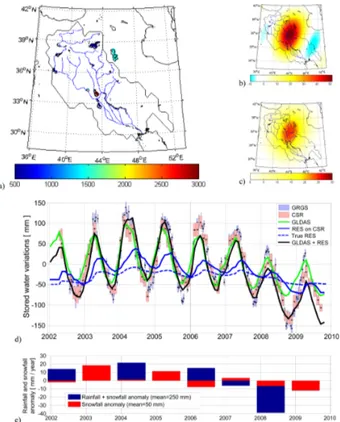
In the TE basin, the nine largest reservoirs have been taken into account (Table 1; Fig. 3a). As suggested by experiment 1, reservoirs outside TE basin are also included to estimate spatial leakage into the Tigris–Euphrates basin. Tharthar lake (2500 km2)
20
constitutes∼35 % of the overall mass variability in the basin, with∼7 m level decrease
(∼17 km3) during the recent three year drought observed between 2007 and 2010. As
it is located near the center of the basin (experiment 1) with a reduced area (experiment 2), it is expected to contribute significantly to the GRACE signal. Predicted impact of reservoir storage to CSR is twice as large as the sum of reservoir storage variations
25
HESSD
9, 11131–11159, 2012GRACE water storage estimates for
the Middle East
L. Longuevergne et al.
Title Page
Abstract Introduction
Conclusions References
Tables Figures
◭ ◮
◭ ◮
Back Close
Full Screen / Esc
Printer-friendly Version Interactive Discussion
Discussion
P
a
per
|
Dis
cussion
P
a
per
|
Discussion
P
a
per
|
Discussio
n
P
a
per
|
While artificial reservoirs cover only 0.8 % of the 790 000 km2 basin, they account for about 10 % of seasonal water storage variations on GRACE (Fig. 3, Table 2). As a result the cycle of water storage variations differ from natural storage variations sim-ulated by GLDAS∆SMS – which does not include reservoirs – causing a 15-day phase shift in the seasonal signal (Table 2). Indeed, the role of irrigation is to store water from
5
times of excess for use during dry periods, which shifts the phase towards the summer season. Summing predicted reservoir storage with GLDAS shows improved agreement with GRACE in both amplitude and phase, RMS differences are also reduced (Table 2, Table S1). The improved agreement with GRACE obtained by addition of reservoir storage to GLDAS is likely greater for interannual variations (Fig. 3, Tables 1, 2),
be-10
cause reservoir management tends to become more important at longer time scales to mitigate drought.
Reservoir storage management appears to explain about∼50 % of mass variations
on GRACE within the Tigris–Euphrates basin over the recent drought from 2007–2009, and not groundwater variations. That is,∆SMS from GLDAS in combination with
reser-15
voir storage (estimated from altimetry) explain most of the GRACE signal, at both sea-sonal and interannual time scales. Long term groundwater changes appear limited, or possibly closely related to surface water via infiltration. This conjecture is supported by the sources of irrigation water (Siebert et al., 2010). Indeed, while 1755 ha are equipped for irrigation within the basin, only 20 % of the water is derived from
ground-20
water. Recent modeling studies also indicate that return flow from irrigation with surface water replenishes groundwater in this region (D ¨oll et al., 2012).
The computed impact of reservoir on GRACE explains most of the apparent mass variability along with∆SMS, however, several sources of error should be highlighted. First, all surface water bodies have not been taken into account in this analysis. For
25
HESSD
9, 11131–11159, 2012GRACE water storage estimates for
the Middle East
L. Longuevergne et al.
Title Page
Abstract Introduction
Conclusions References
Tables Figures
◭ ◮
◭ ◮
Back Close
Full Screen / Esc
Printer-friendly Version Interactive Discussion
Discussion
P
a
per
|
Dis
cussion
P
a
per
|
Discussion
P
a
per
|
Discussio
n
P
a
per
|
lake volume variations from level variations for 7 out of the 9 lakes. Both errors would lead to overestimating the actual long-term depletion from surface water, but do not change the main analysis.
Total water depletion in this region may be caused by two main factors. The first is impoundment and operation of upstream dams, accumulating available water (Jones
5
et al., 2008; Jongerden, 2010). The second is of climatic origin, a drought related to lower than average rainfall and snowfall in the upstream mountains (approximately 60 mm or 47.5 km3over three years with respect to the 250 mm annual mean, Fig. 3e). Half the total depletion in GRACE is linked to soil moisture over the entire region; the other half mainly to depleting Iraqi reservoirs (Fig. 3b). Reservoirs are the first
hydro-10
logical storage elements impacted by decreasing inflows from the contributing area. Droughts are especially critical for downstream reservoirs, which are more dependent on upstream river discharge, and more affected by droughts.
4.3 Surface Water Ocean Topography (SWOT) mission perspective
Accurate GRACE estimates with substantial reservoir and/or lake storage changes
15
depend upon information regarding both location and amount of water masses. Surface water will have a large impact on TWS for large lakes with large volume variations (e.g. Nasser, Guri, and others in the the Supplement). A similar effect is expected in regions with large numbers of small lakes varying coherently (e.g. the Canadian Prairie, Yirdaw et al., 2008).
20
The value of supplementary information from satellite altimetry to monitor lake levels is evident, but is limited by ground track spacing and fixed nadir pointing of recent and current missions. To improve sampling of surface water storage, Papa et al. (2010) pro-posed a multi-satellite product to monitor surface water extent at monthly time scales with 25-km spatial resolution, and construction of resulting hypsometry curves from
25
HESSD
9, 11131–11159, 2012GRACE water storage estimates for
the Middle East
L. Longuevergne et al.
Title Page
Abstract Introduction
Conclusions References
Tables Figures
◭ ◮
◭ ◮
Back Close
Full Screen / Esc
Printer-friendly Version Interactive Discussion
Discussion
P
a
per
|
Dis
cussion
P
a
per
|
Discussion
P
a
per
|
Discussio
n
P
a
per
|
reservoirs. New remote sensing imagery missions enabling land surface classifica-tion (including water extent) will also be launched. For example, several new satellites have been planned within the European Union framework of the Global Monitoring for Environment and Security (CMES). However, none of the missions will be dedicated to continental hydrology, in contrast to the Surface Water and Ocean Topography (SWOT)
5
satellite, a joint NASA-CNES mission planned for a 2019 launch. It will be the first satellite designed to the measurement of continental surface water. SWOT will provide a global inventory of all terrestrial water bodies whose surface area exceeds (250 m2) with sub-monthly sampling (Biancamaria et al., 2010). It should yield global sampling of many water bodies too small to be measured with current satellites. The principal
10
SWOT instrument will be a Ka-band Radar Interferometer (KaRIN), which will provide heights and co-registered all weather imagery of water over 2 swaths, each 60 km wide, with an expected absolute height precision over lakes of 100 mm km−2. The potential of
SWOT measurements will be enhanced when coupled with other remote sensing data, and the GRACE follow-on mission especially. SWOT should considerably improve our
15
understanding of lakes and reservoirs water balance and their impact on continental total water storage.
5 Conclusions
We have investigated how spatial concentration and distribution of water masses affect GRACE water storage estimates. Glaciers, lakes, small-scale groundwater systems,
20
with spatial scales well below the GRACE nominal resolution will act as point masses that contribute to the GRACE signal significantly if water level variations are sufficiently large.
Two parametric synthetic experiments illustrate a number of points relevant to inter-preting GRACE estimates as basin-wide average water storage changes. Conclusions
25
HESSD
9, 11131–11159, 2012GRACE water storage estimates for
the Middle East
L. Longuevergne et al.
Title Page
Abstract Introduction
Conclusions References
Tables Figures
◭ ◮
◭ ◮
Back Close
Full Screen / Esc
Printer-friendly Version Interactive Discussion
Discussion
P
a
per
|
Dis
cussion
P
a
per
|
Discussion
P
a
per
|
Discussio
n
P
a
per
|
is not obvious, especially for small basins. GRACE estimates are unlikely to be equal to a simple sum of reservoir storage variations. Estimates will generally be smaller, but may be larger, depending on the position of the mass within the basin. In addition, mass changes outside a basin of interest may contribute significantly. In most cases, the effect of a concentrated mass will be over-estimated by up to 60 % if the mass is
5
assumed incorrectly to be uniformly distributed.
We have applied these results to several basins which contain significant anthropic reservoir management, in the Middle East, and additional basins from different climate zones in the Supplement. The impact of reservoir on GRACE is generally different from the simple sum of reservoir volume variations distributed over the basin of interest. In
10
the Lower Nile basin, combining information on the position and extent of water bodies and level variations from independent observations (radar altimetry), allows us to quan-tify the impact of reservoir storage on GRACE estimates and to verify that large reser-voirs contribute substantially to the hydrological cycle, at both seasonal and interannual time scales. For example, lake Nasser constitutes only 1.5 % of the Lower Nile basin,
15
but accounts for∼95 % of the water storage changes. In the Tigris–Euphrates basin,
the simple sum of reservoir storage underestimates their actual impact on GRACE by nearly 50 %. Both soil moisture (∼50 %) and predicted impact of reservoir (∼50 %)
account for most of the TWS decline during the 2007–2010 droughts.
Inland lakes provide important sources of fresh water for agricultural and industrial
20
uses in most of the world, and are an important element in the hydrological budget. In dry regions in particular, agriculture relies heavily on surface water and dams are instru-ments of economic policy. With significant storage volumes and relatively short time re-sponse (compared to groundwater), lakes and reservoirs are important targets for mon-itoring by GRACE (e.g. Milzow et al., 2011; Velpuri et al., 2012). Because the influence
25
HESSD
9, 11131–11159, 2012GRACE water storage estimates for
the Middle East
L. Longuevergne et al.
Title Page
Abstract Introduction
Conclusions References
Tables Figures
◭ ◮
◭ ◮
Back Close
Full Screen / Esc
Printer-friendly Version Interactive Discussion
Discussion
P
a
per
|
Dis
cussion
P
a
per
|
Discussion
P
a
per
|
Discussio
n
P
a
per
|
tool in these arid and semi-arid regions where water resources are scarce, irregularly distributed and ground-based programs to monitor water resources limited. It is also clear that GRACE estimates will be improved when it is possible to combine indepen-dent information on spatial distribution of water with GRACE observations, even when concentrated reservoir storage is not a major factor within a basin.
5
Supplementary material related to this article is available online at: http://www.hydrol-earth-syst-sci-discuss.net/9/11131/2012/
hessd-9-11131-2012-supplement.pdf.
Acknowledgements. We used the Matlab computation suite “spherical harmonic transform and its inverse” by Frederic Simons, available at: http://geoweb.princeton.edu/people/simons/
10
software.html. This work has been supported by the National Aeronautics and Space Adminis-tration Grant NNX08AJ84G.
The publication of this article is financed by CNRS-INSU.
HESSD
9, 11131–11159, 2012GRACE water storage estimates for
the Middle East
L. Longuevergne et al.
Title Page
Abstract Introduction
Conclusions References
Tables Figures
◭ ◮
◭ ◮
Back Close
Full Screen / Esc
Printer-friendly Version Interactive Discussion
Discussion
P
a
per
|
Dis
cussion
P
a
per
|
Discussion
P
a
per
|
Discussio
n
P
a
per
|
References
Abdelsalam, M., Youssef, A., Arafat, S., and Alfarhan, M.: Rise and demise of the new lakes of Sahara, Geosphere, 4, 375–386, doi:10.1130/GES00142.1, 2008.
Altinbilek, D.: The role of dams in development, Int. J. Water Resour. D., 18, 9–24, doi:10.1080/07900620220121620, 2002.
5
Aly, A., Froehlich, K., Nada, A., Awad, M., Hamza, M., and Salem, W.: Study of environmental isotope distribution in the Aswan-High-Dam Lake (Egypt) for estimation of evaporation of lake water and its recharge to adjacent groundwater, Environ. Geochem. Hlth., 15, 37–49, 1993. Basgall, M.: DUWC joins iraqi marsh restoration project, Wetland Wire, 6, 1–3, 2003.
Becker, M., LLovel, W., Cazenave, A., Guntner, A., and Cretaux, J.: Recent hydrological
behav-10
ior of the East African great lakes region inferred from GRACE, satellite altimetry and rainfall observations, C. R. Geosci., 342, 223–233, doi:10.1016/j.crte.2009.12.010, 2010.
Bettadpur, S.: Level-2 Gravity Field Product User Handbook, GRACE, The GRACE Project, Center for Space Research, University of Texas, Austin, 327–734, 2007.
Biancamaria, S., Andreadis, K., Durand, M., Clark, E., Rodriguez, E., Mognard, N., Alsdorf, D.,
15
Lettenmaier, D., and Oudin, Y.: Preliminary characterization of SWOT hydrology error budget and global capabilities, IEEE J. Sel. Top. Appl., 3, 6–19, doi:10.1109/JSTARS.2009.2034614, 2010.
Biswas, A. and Tortajada, C.: Development and large dams: a global perspective, Int. J. Water Resour. D., 17, 9–21, doi:10.1080/07900620120025024, 2001.
20
Boy, J. and Chao, B.: Time-variable gravity signal during the water impoundment of China’s Three-Gorges Reservoir, Geophys. Res. Lett., 29, 2200, doi:10.1029/2002GL016457, 2002. Bruinsma, S., Lemoine, J., Biancale, R., and Vales, N.: CNES/GRGS 10-day
grav-ity field models (release 2) and their evaluation, Adv. Space Res., 45, 587–601, doi:10.1016/j.asr.2009.10.012, 2010.
25
Cretaux, J. F., Kouraev, A. V., Papa, F., Berge-Nguyen, M., Cazenave, A., Aladin, N., and Plot-nikov, I. S.: Evolution of sea level of the big Aral Sea from satellite altimetry and its implica-tions for water balance, J. Great Lakes Res., 31, 520–534, 2005.
Cretaux, J. F., Calmant, S., Romanovski, V., Shabunin, A., Lyard, F., Berge-Nguyen, M., Cazenave, A., Hernandez, F., and Perosanz, F.: An absolute calibration site for radar
al-30
HESSD
9, 11131–11159, 2012GRACE water storage estimates for
the Middle East
L. Longuevergne et al.
Title Page
Abstract Introduction
Conclusions References
Tables Figures
◭ ◮
◭ ◮
Back Close
Full Screen / Esc
Printer-friendly Version Interactive Discussion
Discussion
P
a
per
|
Dis
cussion
P
a
per
|
Discussion
P
a
per
|
Discussio
n
P
a
per
|
Cretaux, J. F., Jelinski, W., Calmant, S., Kouraev, A., Vuglinski, V., Berge-Nguyen, M., Gen-nero, M. C., Nino, F., Del Rio, R. A., Cazenave, A., and Maisongrande, P.: SOLS: a lake database to monitor in the near real time water level and storage variations from remote sensing data, Adv. Space Res., 47, 1497–1507, doi:10.1016/j.asr.2011.01.004, 2011. D ¨oll, P., Kaspar, F., and Lehner, B.: A global hydrological model for deriving water
availabil-5
ity indicators: model tuning and validation, J. Hydrol., 270, 105–134, doi:10.1016/S0022-1694(02)00283-4, 2003.
D ¨oll, P., Hoffmann-Dobrev, H., Portmann, F. T., Siebert, S., Eicker, A., Rodell, M., Strassberg, G., Scanlon, B.: Impact of water withdrawals from groundwater and surface water on continental water storage variations, J. Geodyn., 59–60, 143–156, doi:10.1016/j.jog.2011.05.001, 2012.
10
Easterling, D. R., Meehl, G. A., Parmesan, C., Changnon, S. A., Karl, T. R., and Mearns, L. O.: Climate extremes: observations, modeling, and impacts, Science, 289, 2068– 2074, doi:10.1126/science.289.5487.2068, 2000.
Farrell, W. E.: Deformation of the Earth by surface loads, Rev. Geophys. Space Ge., 10, 761– 797, 1972.
15
Frappart, F., Papa, F., Guntner, A., Werth, S., da Silva, J. S., Tomasella, J., Seyler, F., Prigent, C., Rossow, W. B., Calmant, S., and Bonnet, M. P.: Satellite-based estimates of groundwater storage variations in large drainage basins with extensive floodplains, Remote Sens. Envi-ron., 115, 1588–1594, doi:10.1016/j.rse.2011.02.003, 2011.
Gossel, W., Ebraheem, A., Sefelnasr, A. M., Wycisk, P.: A GIS-based flow model for
ground-20
water resources management in the development areas in the Eastern Sahara, Africa, in: Applied Groundwater Studies in Africa, IAH Selected Papers on Hydrogeology, CRC Press/Balkema, Leiden, The Netherlands, 13, 43–64, 2008.
Guntner, A.: Improvement of global hydrological models using GRACE data, Surv. Geophys., 29, 375–397, doi:10.1007/s10712-008-9038-y, 2008.
25
Horwath, M. and Dietrich, R.: Signal and error in mass change inferences from GRACE: the case of Antarctica, Geophys. J. Int., 177, 849–864, doi:10.1111/j.1365-246X.2009.04139.x, 2009.
Hunger, M. and D ¨oll, P.: Value of river discharge data for global-scale hydrological modeling, Hydrol. Earth Syst. Sci., 12, 841–861, doi:10.5194/hess-12-841-2008, 2008.
30
HESSD
9, 11131–11159, 2012GRACE water storage estimates for
the Middle East
L. Longuevergne et al.
Title Page
Abstract Introduction
Conclusions References
Tables Figures
◭ ◮
◭ ◮
Back Close
Full Screen / Esc
Printer-friendly Version Interactive Discussion
Discussion
P
a
per
|
Dis
cussion
P
a
per
|
Discussion
P
a
per
|
Discussio
n
P
a
per
|
Jongerden, J.: Dams and politics in turkey: utilizing water, developing conflict, Middle East Policy, 1, 17, 137–143, doi:10.1111/j.1475-4967.2010.00432.x, 2010.
Jones, C., Sultan, M., Yan, E., Milewski, A., Hussein, M., Al-Dousari, A., Al-Kaisy, S., and Becker, R.: Hydrologic impacts of engineering projects on the Tigris–Euphrates system and its marshlands, J. Hydrol., 353, 59–75, doi:10.1016/j.jhydrol.2008.01.029, 2008.
5
Kolars, J.: Problems of international river management: the case of the Euphrates, in: Inter-national Waters of the Middle East, from Tigris–Euphrates to Nile, edited by: Biswas, A. K., Oxford University Press, New York, 1994.
Landerer, F. W. and Swenson, S. C.: Accuracy of scaled GRACE terrestrial water storage esti-mates, Water Resour. Res., 48, W04531, doi:10.1029/2011wr011453, 2012.
10
Lemoine, J.-M., Bruinsma, S., Loyer, S., Biancale, R., Marty, J.-C., Perosanz, F., and Balmino, G.: Temporal gravity field models inferred from GRACE data, Adv. Space Res., 39, 1620–1629, doi:10.1016/j.asr.2007.03.062, 2007.
Liu, J. G. and Yang, H.: Spatially explicit assessment of global consumptive water uses in cropland: green and blue water, J. Hydrol., 384, 187–197, doi:10.1016/j.jhydrol.2009.11.024,
15
2010.
Longuevergne, L., Scanlon, B. R., and Wilson, C. R.: GRACE Hydrological estimates for small basins: evaluating processing approaches on the High Plains Aquifer, USA, Water Resour. Res., 46, W11517, doi:10.1029/2009wr008564, 2010.
Mutin, G.: L’eau dans le monde arabe. Mise `a jour de la premi `ere ´edition, Paris, Ellipses ´Edition
20
Marketing SA, 2000 (“ Carrefours de G ´eographie”), ´Etudes rurales, 155–156, available at: http://arxiv.org/ftp/arxiv/papers/0911/0911.4948.pdf (last access: 1 October 2012), 2009. Milzow, C., Krogh, P. E., and Bauer-Gottwein, P.: Combining satellite radar altimetry, SAR
sur-face soil moisture and GRACE total storage changes for hydrological model calibration in a large poorly gauged catchment, Hydrol. Earth Syst. Sci., 15, 1729–1743,
doi:10.5194/hess-25
15-1729-2011, 2011.
Oki, T. and Sud, Y. C.: Design of Total RunoffIntegrating Pathways (TRIP) – a global river chan-nel network, Earth Interact., 2, available at: http://hydro.iis.u-tokyo.ac.jp/taikan/TRIPDATA/ TRIPDATA.html (last access: 1 October 2012), 1998.
Papa, F., Prigent, C., Aires, F., Jimenez, C., Rossow, W. B., and Matthews, E.: Interannual
30
HESSD
9, 11131–11159, 2012GRACE water storage estimates for
the Middle East
L. Longuevergne et al.
Title Page
Abstract Introduction
Conclusions References
Tables Figures
◭ ◮
◭ ◮
Back Close
Full Screen / Esc
Printer-friendly Version Interactive Discussion
Discussion
P
a
per
|
Dis
cussion
P
a
per
|
Discussion
P
a
per
|
Discussio
n
P
a
per
|
Pokhrel, Y. N., Hanasaki, N., Yeh, P. J. F., Yamada, T. J., Kanae, S., and Oki, T.: Model estimates of sea-level change due to anthropogenic impacts on terrestrial water storage, Nat. Geosci., 5, 389–392, doi:10.1038/ngeo1476, 2012.
Rodell, M., Houser, P. R., Jambor, U., Gottschalck, J., Mitchell, K., Meng, C. J., Arsenault, K., Cosgrove, B., Radakovich, J., Bosilovich, M., Entin, J. K., Walker, J. P., Lohmann, D., and
5
Toll, D.: The global land data assimilation system, B. Am. Meteorol. Soc., 85, 381–394, doi:10.1175/bams-85-3-381, 2004.
Rodell, M., Velicogna, I., and Famiglietti, J. S.: Satellite-based estimates of groundwater deple-tion in India, Nature, 460, 999–1002, doi:10.1038/nature08238, 2009.
Rosegrant, M. W.: Water Resources in the Twenty-First Century: Challenges and Implications
10
for Action, Food, Agriculture, and the Environment Discussion Paper 20, International Food Policy Research Institute, Washington, DC, p. 4, 1997.
Rowlands, D. D., Luthcke, S. B., McCarthy, J. J., Klosko, S. M., Chinn, D. S., Lemoine, F. G., Boy, J. P., and Sabaka, T. J.: Global mass flux solutions from GRACE: a comparison of pa-rameter estimation strategies – Mass concentrations versus Stokes coefficients, J. Geophys.
15
Res.-Sol. Earth, 115, B01403, doi:10.1029/2009jb006546, 2010.
Sadek, M. F., Shahin, M. M., and Stigter, C. J.: Evaporation from the reservoir of the High Aswan Dam, Egypt: a new comparison of relevant methods with limited data, Theor. Appl. Climatol., 56, 57–66, doi:10.1007/bf00863783, 1997.
Scanlon, B. R., Faunt, C. C., Longuevergne, L., Reedy, R. C., Alley, W. M., McGuire, V. L., and
20
McMahon, P. B.: Groundwater depletion and sustainability of irrigation in the US High Plains and Central Valley, P. Natl. Acad. Sci. USA, 109, 9320–9325, doi:10.1073/pnas.1200311109, 2012a.
Scanlon, B. R., Longuevergne, L., and Long, D.: Ground referencing GRACE satellite estimates of groundwater storage changes in the California Central Valley, USA, Water Resour. Res.,
25
48, W04520, doi:10.1029/2011wr011312, 2012b.
Schmidt, R., Flechtner, F., Meyer, U., Neumayer, K. H., Dahle, C., Konig, R., and Kusche, J.: Hydrological signals observed by the GRACE satellites, Surv. Geophys., 29, 319–334, doi:10.1007/s10712-008-9033-3, 2008.
Shamsudduha, M., Taylor, R. G., and Longuevergne, L.: Monitoring groundwater storage
30
HESSD
9, 11131–11159, 2012GRACE water storage estimates for
the Middle East
L. Longuevergne et al.
Title Page
Abstract Introduction
Conclusions References
Tables Figures
◭ ◮
◭ ◮
Back Close
Full Screen / Esc
Printer-friendly Version Interactive Discussion
Discussion
P
a
per
|
Dis
cussion
P
a
per
|
Discussion
P
a
per
|
Discussio
n
P
a
per
|
Siebert, S., Burke, J., Faures, J. M., Frenken, K., Hoogeveen, J., D ¨oll, P., and Portmann, F. T.: Groundwater use for irrigation – a global inventory, Hydrol. Earth Syst. Sci., 14, 1863–1880, doi:10.5194/hess-14-1863-2010, 2010.
Singh, A., Seitz, F., and Schwatke, C.: Inter-annual water storage changes in the Aral Sea from multi-mission satellite altimetry, optical remote sensing, and GRACE satellite gravimetry,
Re-5
mote Sens. Environ., 123, 187–195, 2012.
Simons, F. J., Dahlen, F. A., and Wieczorek, M. A.: Spatiospectral concentration on a sphere, Siam Rev., 48, 504–536, doi:10.1137/s0036144504445765, 2006.
Sultan, M., Sturchio, N., Hassan, F. A., Hamdan, M. A. R., Mahmood, A. M., El Alfy, Z., and Stein, T.: Precipitation source inferred from stable isotopic composition of Pleistocene
10
groundwater and carbonate deposits in the western desert of Egypt, Quaternary Res., 48, 29–37, doi:10.1006/qres.1997.1907, 1997.
Swenson, S. and Wahr, J.: Post-processing removal of correlated errors in GRACE data, Geo-phys. Res. Lett., 33, L08402, doi:10.1029/2005gl025285, 2006.
Swenson, S. and Wahr, J.: Monitoring the water balance of Lake Victoria, East Africa, from
15
space, J. Hydrol., 370, 163–176, doi:10.1016/j.jhydrol.2009.03.008, 2009.
Tapley, B. D., Bettadpur, S., Ries, J. C., Thompson, P. F., and Watkins, M. M.: GRACE measurements of mass variability in the Earth system, Science, 305, 503–505, doi:10.1126/science.1099192, 2004.
Tiwari, V. M., Wahr, J., and Swenson, S.: Dwindling groundwater resources in
North-20
ern India, from satellite gravity observations, Geophys. Res. Lett., 36, L18401, doi:10.1029/2009gl039401, 2009.
Velpuri, N. M., Senay, G. B., and Asante, K. O.: A multi-source satellite data approach for modelling Lake Turkana water level: calibration and validation using satellite altimetry data, Hydrol. Earth Syst. Sci., 16, 1–18, doi:10.5194/hess-16-1-2012, 2012.
25
Wada, Y., van Beek, L. P. H., van Kempen, C. M., Reckman, J., Vasak, S., and Bierkens, M. F. P.: Global depletion of groundwater resources, Geophys. Res. Lett., 37, L20402, doi:10.1029/2010gl044571, 2010.
Wahr, J., Molenaar, M., and Bryan, F.: Time variability of the Earth’s gravity field: hydrological and oceanic effects and their possible detection using GRACE, J. Geophys. Res.-Sol. Earth,
30
103, 30205–30229, doi:10.1029/98jb02844, 1998.
HESSD
9, 11131–11159, 2012GRACE water storage estimates for
the Middle East
L. Longuevergne et al.
Title Page
Abstract Introduction
Conclusions References
Tables Figures
◭ ◮
◭ ◮
Back Close
Full Screen / Esc
Printer-friendly Version Interactive Discussion
Discussion
P
a
per
|
Dis
cussion
P
a
per
|
Discussion
P
a
per
|
Discussio
n
P
a
per
|
of China and comparison with in situ measurements, Water Resour. Res., 47, W12502, doi:10.1029/2011wr010534, 2011.
Werth, S. and G ¨untner, A.: Calibration analysis for water storage variability of the global hy-drological model WGHM, Hydrol. Earth Syst. Sci., 14, 59–78, doi:10.5194/hess-14-59-2010, 2010.
5
Xie, H., Longuevergne, L., Ringler, C., and Scanlon, B. R.: Calibration and evaluation of a semi-distributed watershed model of Sub-Saharan Africa using GRACE data, Hydrol. Earth Syst. Sci., 16, 3083–3099, doi:10.5194/hess-16-3083-2012, 2012.
Yirdaw, S. Z., Snelgrove, K. R., and Agboma, C. O.: GRACE satellite observations of terrestrial moisture changes for drought characterization in the Canadian Prairie, J. Hydrol., 356, 84–
10
92, doi:10.1016/j.jhydrol.2008.04.004, 2008.
WCD: Dams and Development – a New Framework for Decision Making, Earthscan, London, 2000.
World Bank: The World’s Experience with Large Dams: a Preliminary Review of Impacts, World Bank, Washington, DC, 1998.
HESSD
9, 11131–11159, 2012GRACE water storage estimates for
the Middle East
L. Longuevergne et al.
Title Page
Abstract Introduction
Conclusions References
Tables Figures
◭ ◮
◭ ◮
Back Close
Full Screen / Esc
Printer-friendly Version Interactive Discussion
Discussion
P
a
per
|
Dis
cussion
P
a
per
|
Discussion
P
a
per
|
Discussio
n
P
a
per
|
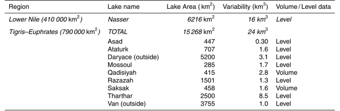
Table 1.Lake and reservoir data summary.
Region Lake name Lake Area ( km2) Variability (km3) Volume / Level data
Lower Nile (410 000km2) Nasser 6216km2 16 km3 Level
Tigris–Euphrates (790 000km2) TOTAL 15 268km2 24 km3
Asad 447 0.30 Level
Ataturk 707 1.6 Level
Daryace (outside) 5200 3.1 Level
Mossoul 285 1.7 Level
Qadisiyah 415 2.8 Volume
Razazah 1501 1.3 Level
Saksak 458 1.6 Volume
Tharthar 2500 8.5 Level
HESSD
9, 11131–11159, 2012GRACE water storage estimates for
the Middle East
L. Longuevergne et al.
Title Page
Abstract Introduction
Conclusions References
Tables Figures
◭ ◮
◭ ◮
Back Close
Full Screen / Esc
Printer-friendly Version Interactive Discussion
Discussion
P
a
per
|
Dis
cussion
P
a
per
|
Discussion
P
a
per
|
Discussio
n
P
a
per
|
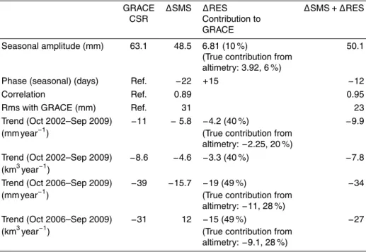
Table 2. Comparison between GRACE, ∆SMS and reservoir (∆RES) for Tigris–Euphrates basin. Please refer to supplementary material Table S1 for comparison with more LSM models.
GRACE ∆SMS ∆RES ∆SMS+ ∆RES CSR Contribution to
GRACE
Seasonal amplitude (mm) 63.1 48.5 6.81 (10 %) 50.1 (True contribution from
altimetry: 3.92, 6 %)
Phase (seasonal) (days) Ref. −22 +15 −12
Correlation Ref. 0.89 0.95
Rms with GRACE (mm) Ref. 31 23
Trend (Oct 2002–Sep 2009) −11 −5.8 −4.2 (40 %) −9.9 (mm year−1) (True contribution from
altimetry:−2.25, 20 %)
Trend (Oct 2002–Sep 2009) −8.6 −4.6 −3.3 (40 %) −7.8 (km3year−1)
Trend (Oct 2006–Sep 2009) −39 −15.7 −19 (49 %) −34 (mm year−1) (True contribution from
altimetry:−11, 28 %)
Trend (Oct 2006–Sep 2009) −31 12 −15 (49 %) −27 (km3year−1) (True contribution from
HESSD
9, 11131–11159, 2012GRACE water storage estimates for
the Middle East
L. Longuevergne et al.
Title Page
Abstract Introduction
Conclusions References
Tables Figures
◭ ◮
◭ ◮
Back Close
Full Screen / Esc
Printer-friendly Version Interactive Discussion
Discussion
P
a
per
|
Dis
cussion
P
a
per
|
Discussion
P
a
per
|
Discussio
n
P
a
per
|
Fig. 2. (a) Apparent water storage change for a uniform 2.7 m water layer distributed over Lake Nasser after hard SH truncation at degree 50 (similar to GRGS), superimposed on an outline of the Lower Nile basin (410 000 km2). Note the negative sidelobes associated with hard truncation. The outline of the area of interest is artificially set at the Egypt–Sudan border to compute the impact of a single point mass located at the border of the area of interest.
HESSD
9, 11131–11159, 2012GRACE water storage estimates for
the Middle East
L. Longuevergne et al.
Title Page
Abstract Introduction
Conclusions References
Tables Figures
◭ ◮
◭ ◮
Back Close
Full Screen / Esc
Printer-friendly Version Interactive Discussion
Discussion
P
a
per
|
Dis
cussion
P
a
per
|
Discussion
P
a
per
|
Discussio
n
P
a
per
|
Fig. 3. (a)Reservoir distribution and standard deviation of lake level variations in mm for each of the nine Tigris–Euphrates reservoirs and lakes; (b)spatial distribution of estimated water storage variations after hard truncation at degree 50 (similar to GRGS);(c)same as(b)but after truncation at degree 60 and 300-km Gaussian smoothing (similar to CSR)(d)Water storage variations for the Tigris–Euphrates basin from GRACE, GLDAS SM, predicted reservoir storage (RES) impact on CSR and the simple sum of reservoir storage simple distributed over the basin.