BGD
11, 4085–4122, 2014
Lena River Delta formation during the
Holocene
D. Bolshiyanov et al.
Title Page Abstract Introduction
Conclusions References
Tables Figures
◭ ◮
◭ ◮
Back Close
Full Screen / Esc
Printer-friendly Version Interactive Discussion
Discussion
P
a
per
|
D
iscussion
P
a
per
|
Discussion
P
a
per
|
Discuss
ion
P
a
per
|
Biogeosciences Discuss., 11, 4085–4122, 2014 www.biogeosciences-discuss.net/11/4085/2014/ doi:10.5194/bgd-11-4085-2014
© Author(s) 2014. CC Attribution 3.0 License.
Open Access
Biogeosciences
Discussions
This discussion paper is/has been under review for the journal Biogeosciences (BG). Please refer to the corresponding final paper in BG if available.
Lena River Delta formation during the
Holocene
D. Bolshiyanov1,2, A. Makarov1,2, and L. Savelieva2
1
State Research Center, Arctic and Antarctic Research Institute, St. Petersburg, Russia
2
St. Petersburg State University, St. Petersburg, Russia
Received: 31 January 2013 – Accepted: 7 May 2013 – Published: 14 March 2014
Correspondence to: D. Bolshiyanov ([email protected]), A. Makarov ([email protected]), and L. Savelieva ([email protected])
BGD
11, 4085–4122, 2014
Lena River Delta formation during the
Holocene
D. Bolshiyanov et al.
Title Page Abstract Introduction
Conclusions References
Tables Figures
◭ ◮
◭ ◮
Back Close
Full Screen / Esc
Printer-friendly Version Interactive Discussion
Discussion
P
a
per
|
D
iscussion
P
a
per
|
Discussion
P
a
per
|
Discuss
ion
P
a
per
Abstract
The Lena River Delta, the largest delta of the Arctic Ocean, differs from other deltas because it consists mainly of organomineral sediments, commonly called peat, that contain a huge organic carbon reservoir. The analysis of Delta sediment radiocarbon ages showed that they could not have formed as peat during floodplain bogging, but
5
accumulated when Laptev Sea water level was high and green mosses and sedges grew and were deposited on the surface of flooded marshes.
The Lena River Delta formed as organomineral masses and layered sediments ac-cumulated during transgressive phases when sea level rose. In regressive phases, the islands composed of these sediments and other, more ancient islands were eroded.
10
Each new sea transgression led to further accumulation of layered sediments. As a re-sult of alternating transgressive and regressive phases the first alluvial-marine terrace formed, consisting of geological bodies of different ages. Determining the formation age of different areas of the first terrace and other marine terraces on the coast allowed the periods of increasing (8–6 Ka, 4.5–4 Ka, 2.5–1.5 Ka, 0.4–0.2 Ka) and decreasing (5 Ka,
15
3 Ka, 0.5 Ka) Laptev Sea levels to be distinguished in the Lena Delta area.
1 Introduction
Until now the geomorphological structure of the Lena River Delta has been most fully explained by the scheme proposed by Grigoriev (1993), who distinguished three ter-races above the delta floodplain; the third terrace is composed of ice complex rocks,
20
the second terrace is composed of Arga Muora-Sise Island sands, and the first ter-race to the floodplain is composed of silt and sand, enriched to varying degrees in plant remains which have often completely displaced the mineral part. Subsequent re-searchers in the Delta proceeded from this scheme, presuming that the Delta was a fluvial formation (Schwamborn et al., 2004; Schirrmeister et al., 2003). Geological and
25
BGD
11, 4085–4122, 2014
Lena River Delta formation during the
Holocene
D. Bolshiyanov et al.
Title Page Abstract Introduction
Conclusions References
Tables Figures
◭ ◮
◭ ◮
Back Close
Full Screen / Esc
Printer-friendly Version Interactive Discussion
Discussion
P
a
per
|
D
iscussion
P
a
per
|
Discussion
P
a
per
|
Discuss
ion
P
a
per
|
Delta terraces were formed as deposits made by the flooding river. i.e. river terraces. Rather, they were formed by Laptev sea level fluctuations over a long period of time.
The aim of this paper is to elucidate the structure of the first Lena River Delta terrace. This structure reflects sea level fluctuations that resulted in periods of Delta erosion alternating with periods of Delta development during which organomineral sediments
5
preferentially accumulated.
2 Study area
The Lena River Delta is the largest Arctic delta with an area of about 29 630 km2 (Bol-shiyanov et al., 2013). It has a significant impact not only on the Laptev Sea regime, but also on the entire Arctic Ocean due to fresh river water discharge to the smallest
10
and least saline of the Earth’s oceans. The Delta was formed by the accumulation of sediments from the river and from the erosion and abrasion of ancient landforms due to sea level fluctuations and the tectonic movements of the Earth’s crust. The huge fan-shaped Delta extends for 190 km from north to south (72.0–73.8◦N) and for 250 km from west to east (122.0–129.5◦E). The length of the entire Delta coastline, from the
15
Olenek Channel mouth to the Bykovskaya Channel mouth, is about 1,930 km.
The climate in the Lena River Delta area is Arctic continental, characterized by a mean annual air temperature of −13◦C, a mean January temperature of −32◦C, a mean July temperature of+6.5◦C, and annual rainfall of 190 mm. The Delta is under-lain by continuous permafrost 500–600 m thick. The active (annually thawed) layer is
20
BGD
11, 4085–4122, 2014
Lena River Delta formation during the
Holocene
D. Bolshiyanov et al.
Title Page Abstract Introduction
Conclusions References
Tables Figures
◭ ◮
◭ ◮
Back Close
Full Screen / Esc
Printer-friendly Version Interactive Discussion
Discussion
P
a
per
|
D
iscussion
P
a
per
|
Discussion
P
a
per
|
Discuss
ion
P
a
per
3 Methods
The primary method used in this study was geomorphological mapping, accompa-nied by a simultaneous study of the geological and geocryological Delta structure. During 2000–2008, geomorphological maps were compiled for different Delta areas (Bolshiyanov et al., 2013), and in 2009, the geomorphological map of the entire Delta
5
was compiled (Makarov, 2009). The mapping process consisted of direct field mea-surements of the altitude of various Delta terraces, compiling descriptions of terrace microrelief, and deciphering the relief shown in aerial photographs. After the terrace sediments were sampled and radiocarbon dated, the relief elements distinguished in the compiled maps were assigned ages. The geological structure of the islands and
10
the coast were studied by geologically describing key sections exposed by river erosion and sea abrasion. Samples for radiocarbon dating, spore-pollen analysis, and analysis of the plant macroremains from the organomineral masses that make up the islands were taken from these key sections. Holocene marine terraces in the Delta area were also investigated and dated. Radiocarbon dating was carried out in the
geochronol-15
ogy laboratory at St. Petersburg State University, and the results are presented below. The liquid scintillation method was used for 14C dating as described by Arslanov et al. (1993). Radiocarbon dates are reported throughout the text as uncalibrated ages.
Pollen analyses were carried out at St. Petersburg State University. Peat samples were prepared according to the alkaline method of von Post described by Grichuk and
20
Zaklinskaya (1948). Pollen and spores were identified at magnifications of 400X with the aid of published pollen keys and atlases (Kupriyanova and Alyoshina, 1972, 1978; Moore et al., 1991) and a modern pollen reference collection at St. Petersburg State University. About 400 terrestrial pollen grains per sample were counted and used for percentage calculations of each identified taxon. The Tilia and Tilia-Graph software
25
BGD
11, 4085–4122, 2014
Lena River Delta formation during the
Holocene
D. Bolshiyanov et al.
Title Page Abstract Introduction
Conclusions References
Tables Figures
◭ ◮
◭ ◮
Back Close
Full Screen / Esc
Printer-friendly Version Interactive Discussion
Discussion
P
a
per
|
D
iscussion
P
a
per
|
Discussion
P
a
per
|
Discuss
ion
P
a
per
|
Peat samples for botanical analysis were carefully flushed with water through a 0.10– 0.25 mm aperture sieve until the flushing water was completely clear. Plant fibers thus obtained were put on a large glass slide (9×6 or 9×12 cm), mixed with a little water, dispersed in a thin layer, and examined under a microscope at 100× magnification
without a cover glass. When the plant species was difficult to identify stronger
magnifi-5
cation (up to 450×) was used to view individual parts of plant remains, and in this case the sample was covered with a cover glass. The species of all plant samples were de-termined by using special atlases (Katz et al., 1977; Dombrovskaya et al., 1959). The percentage of each species was visually estimated in each sample and is expressed as a percentage rounded to the nearest 5 %. Plant residues encountered in quantities of
10
less than 5 % were marked as being single (sol.). Determination of plant macroresidues was carried out in the Department of Biogeograpphy at St. Petersburg State University.
4 Results
4.1 Organomineral Delta deposits
Our study of geological and geomorphological Lena Delta structure showed that the
15
first terrace, which is up to 15 m high above sea level, is composed partly of sands, but mostly of organomineral sediments. The latter are called “layered sediments”, since this term most precisely reflects the essence of the structure and the composition of these sediments (Fig. 1). These layered plant masses, enriched in sand and silt to varying degrees, are made up of undecomposed green mosses, detritus of sedges and other
20
plants, and woody remains. Horizontal and wavy bedding of sediments indicates that the plant remains were deposited in a shallow basin. These sediments were annually frozen, as indicated by the extensive development of syngenetic massive ice wedges. In general these Holocene sediments are very similar to Ice Complex (IC) deposits, although IC deposits formed at a different time, at the close of the Late Pleistocene,
25
BGD
11, 4085–4122, 2014
Lena River Delta formation during the
Holocene
D. Bolshiyanov et al.
Title Page Abstract Introduction
Conclusions References
Tables Figures
◭ ◮
◭ ◮
Back Close
Full Screen / Esc
Printer-friendly Version Interactive Discussion
Discussion
P
a
per
|
D
iscussion
P
a
per
|
Discussion
P
a
per
|
Discuss
ion
P
a
per
of sediment formation was probably very similar and depended, to a major extent, on sea level fluctuations.
The botanical composition of the peat that makes up the islands is of great impor-tance for understanding the origin of the sediment deposits. On the western extremity of Sobo Island on the Bootulu Channel side Gusev (1953) described the second (as
5
he presumed) 8 m high terrace. The lower peaty part of this terrace is composed of 50 %Carex caespitosaandCarex limosa, 35 %Calliergon cordifolium, C.sp., Drepan-ocladussp., andPoludella squarrosa, and 15 % undefined herbal remains. The peat is 15 % decomposed. The middle part of this terrace consists of 30 % sedges;Calliergon cordifolium, C.cuspidatum, Cirriphylumsp.,Drepanocladus exanulatus, D. fluitans,and
10
D.venicosusmake up the remaining 70 %. The peat is 5 % decomposed.
In the upper part of this terrace new species Drepanocladus sedtheri and Mnium
sp. are found, and the peat is 5 % decomposed. One km downstream from Bulunkan Bay, along the Bykovskaya Channel, the base of the 6 m high section is composed of strongly arenaceous peat, 70 % of which is made up of Calliergon cordifolium, 15
C.giganteum, Drepanocladus exannulatus, D. Sendtheri,andD. venicasus,while 15 % is Carex sp. and 15 % is unidentifiable remains. Single tree trunks up to 8 cm in di-ameter are found here. In the middle part of this terrace the peat is denser and the layering is less pronounced. Sixty percent of this section is composed of Carex cae-spitosa, C. limosa,and C.sp., and 20 % of Calliergon cordifolium, C. giganteum,and
20
Scorpidium scorpioides. The remaining 20 % is made up ofDrepanocladus exomu-latus, D.sencther, and D. venicosus. The upper 2 m of the section are represented by horizontally layered fine-grained quartz sands with abundant interbedded peat and peat detritus.
As can be seen from the vegetation descriptions (Gusev, 1953), peat-forming plants
25
BGD
11, 4085–4122, 2014
Lena River Delta formation during the
Holocene
D. Bolshiyanov et al.
Title Page Abstract Introduction
Conclusions References
Tables Figures
◭ ◮
◭ ◮
Back Close
Full Screen / Esc
Printer-friendly Version Interactive Discussion
Discussion
P
a
per
|
D
iscussion
P
a
per
|
Discussion
P
a
per
|
Discuss
ion
P
a
per
|
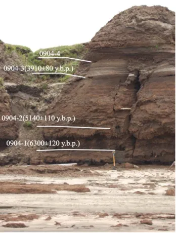
Our observations indicate that section 0904 (Fig. 1) on the left slope of the Bulkur Channel (72◦09′02.8′′N. 126◦15′57.8′′E) is of particular interest. The first terrace, up to 13.5 m above the low-water mark in the Bulkur Channel, is composed of organomineral sediments which exist as isolated silt pinnacle outliers that are separated from each other by valleys which formed as ice veins melted. The width of the silt pinnacle outliers
5
approximately corresponds to the size of the polygons on the terrace surface. In one of these silt pinnacle outliers, the following units are exposed in ascending order:
– towpath (0–3.5 m above the water’s edge), up to 40 m wide, composed of sand with sunken wood;
– plant remains in a well-developed 4.7 m thick horizontal layer (sample 0904-1
10
taken at a height of 3.5 m, sample 2 at a height of 4.7 m, and sample 0904-3 at a height of 8.2 m);
– 0.8 m thick sand with interbedded plant remains;
– layered plant sediments with visible thickness of 1 m (sample 0904-4 taken from the height of 9 m above water edge, at the base of the layer);
15
– layered plant sediments in a 3–3.5 m thick sliding block.
As is seen from Fig. 1, the organic mass in the lower half of the section (below the sandy layer) formed in the time interval between 6300 and 3900 yr b.p. (years before present). There may have been a break in sedimentation between the two lower dated layers of sediments. In the time interval between 5100 and 3900 yr b.p., 3.5 m of plant
20
remains accumulated at an average rate of 3 mm yr−1 or 30 cm per 100 yr. Above this layer, sands and layered sediments were again deposited.
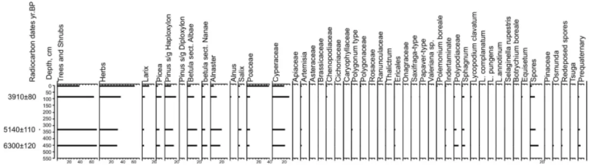
The results of pollen analysis from sediments of section 0904 are shown in the di-agram (Fig. 2) The spore-pollen spectra of the three lower samples (0904-1, 0904-2, 0904-3) are uniform. Sediments are dominated by pollen of arboraceous and shrub
25
BGD
11, 4085–4122, 2014
Lena River Delta formation during the
Holocene
D. Bolshiyanov et al.
Title Page Abstract Introduction
Conclusions References
Tables Figures
◭ ◮
◭ ◮
Back Close
Full Screen / Esc
Printer-friendly Version Interactive Discussion
Discussion
P
a
per
|
D
iscussion
P
a
per
|
Discussion
P
a
per
|
Discuss
ion
P
a
per
represented by three taxa; Pinus s/g Haploxilon, Betula sp., and Alnus fruticosa ac-count for 20 to 30 %. Pollen ofPicea(8 %),Larix (3–5 %), andSalix (2–5 %) are also present. Herbaceous vegetation is represented by pollen of the family Cyperaceae (20–27 %) and motley grass-herb groups including Poaceae, Brassicaceae, Artemisia, Asteraceae, Rosaceae, etc. Spores are predominantly from sphagnum mosses, ferns,
5
different Lycopodium species, and Selaginella sibirica. All samples contain sporadic pollen grains and spores of pre-Quaternary conifers. Pollen and spores in all samples are well preserved.
The spore-pollen spectrum of the upper sample (0904-4, from a height of 9 m above water edge) differs from those described above by the predominance of grass pollen
10
representing the families Poaceae (38 %) and Cyperaceae (20 %), and miscellaneous herbs. There is also a high content of larch pollen (15 %), and sporadic forms of soft-wood stomata are recorded that could not be assigned to genera due to their poor preservation.
Among plant macroremains in the lower part of the section (sample 0904-1), sedges
15
(30 %), cotton grass (5 %), and equisetum (5 %) were found. Mosses are represented byDrepanocladus(25 %),Tomethypnym(25 %), andCalliergon(5 %). There are single occurrences ofComarum palustre,Bryum,andAulacomnium.
In sample 0904-2 the sedge species composition changes slightly.Carex cespitosa
virtually disappears, but Carex rariflora appears (10 %). Carex aguatilis accounts for
20
10 %. Individual Equisetum occurs, and grasses appear (10 %). In addition, there is an increasing diversity of mosses, including Calliergon gigantenum (20 %), Drepan-ocladus (20 %),Calliergon cordifolium(15 %), andBryum(5 %).
In sample 0904-3, herbaceous plants are again dominated by sedges of different species which in total account for 30 %. Equisetum is present in small amounts and
25
BGD
11, 4085–4122, 2014
Lena River Delta formation during the
Holocene
D. Bolshiyanov et al.
Title Page Abstract Introduction
Conclusions References
Tables Figures
◭ ◮
◭ ◮
Back Close
Full Screen / Esc
Printer-friendly Version Interactive Discussion
Discussion
P
a
per
|
D
iscussion
P
a
per
|
Discussion
P
a
per
|
Discuss
ion
P
a
per
|
Sample 0904-4 is notable for a lower share of sedges (25 %), and a rather high con-tent of grasses (25 %) andDrepanocladus (30 %). Among mosses, Calliergon cordi-folium(15 %) and Campyllum (5 %) are also recorded.
All samples are very rich in organic material that has not decomposed very much (the highest amount of decomposition, 30 %, found in the lowest sample) and is very
5
well preserved. All the species encountered currently grow in tundra.
Results of analyses show that the vegetation composition indicated by spore-pollen spectra differs significantly from that indicated by the plant macroremains. This diff er-ence is particularly pronounced in the mosses. In layered sediments sphagnum and lycopod spores are present, and layered sediments are mainly composed of green
10
mosses. The pollen and plant remains of the herbaceous vegetation are more or less similar and sedge pollen and macroremains prevail. In the upper sample, changes in the composition of herbaceous plant pollen correspond to changes in the composition of herb remains. Both macroremains and spore-pollen analyses showed an increas-ing presence of grasses and a decreasincreas-ing presence of sedges. Macroremains contain
15
virtually no arboraceous species, which probably indicates that the described area re-mained in the tundra zone during the time interval from 6300 to 3900 yr b.p.
Our own and previous studies suggest that the organic part of the layered sedi-ments is virtually undecomposed. The maximum 15 % of peat decomposition degree determined by Gusev (1953) is accounted for by indefinite plant remains, i.e. by plant
20
detritus, which is not a product of decomposition, but was transported to this location by water, as were the green mosses and herbaceous plants. As is evident from the descriptions, there are abundant remains of both sedge roots and leaves in layered sediments. Peat is generally not characterized by the presence of sedge leaves, since they decompose quickly (Denisenkov, 2000).
25
BGD
11, 4085–4122, 2014
Lena River Delta formation during the
Holocene
D. Bolshiyanov et al.
Title Page Abstract Introduction
Conclusions References
Tables Figures
◭ ◮
◭ ◮
Back Close
Full Screen / Esc
Printer-friendly Version Interactive Discussion
Discussion
P
a
per
|
D
iscussion
P
a
per
|
Discussion
P
a
per
|
Discuss
ion
P
a
per
up 30–40 % of the volume weight of these sections. In other sections,(Closest to the Laptev Sea) sandy material accounts for less than 10 % in layered sediment sections.
Layered sediments accumulate at a very high rate, ranging from 0.2 to 1.6 m per hundred years. In the Samoylov Island borehole, the lower metre of sediments accu-mulated during several dozens of years only.
5
In layered sediment sections of the first terrace up to 8 m thick the upper and lower parts exhibit a nearly identical degree of moss decomposition.
Wood remains protruding from exposures are, as a rule, much younger than the accumulations of mosses and plant detritus, as was shown by radiocarbon dating. The location of the dated first terrace organomineral sediment sections is shown in Fig. 3;
10
dates are given in Table 1.
4.2 Geomorphological Delta structure
The geological and geomorphological structure of Delta islands obviously points to the fact that the first terrace formed during several phases of alternating accumulation and erosion of sediments. Island outlines clearly illustrate different ages of sediments on
15
the same first terrace surface. Figure 4 presents an aerial picture of Samoylov Island. Its eastern part is polygonal tundra made up almost by organic layered sediments up to several metres thick. A developed system of polygons and thermokarst lakes points to the comparatively long existence of the first terrace surface. The western part of the island is composed of sands adjoining the eastern part of the island. Surface sands
20
on the western part of the first terrace exhibit only rudimentary polygonal forms and are covered with sparser vegetation than is the eastern part of the island. The first terrace surface is younger than a similar surface on the eastern part of the island. The western slope of the island is most affected by flood water, which leaves an annual deposit of sandy material atop it. A large amount of driftwood accumulates here, i.e.
25
BGD
11, 4085–4122, 2014
Lena River Delta formation during the
Holocene
D. Bolshiyanov et al.
Title Page Abstract Introduction
Conclusions References
Tables Figures
◭ ◮
◭ ◮
Back Close
Full Screen / Esc
Printer-friendly Version Interactive Discussion
Discussion
P
a
per
|
D
iscussion
P
a
per
|
Discussion
P
a
per
|
Discuss
ion
P
a
per
|
300–500 yr old sands were deposited on 2600 yr old eroded layered sediments near the modern water’s edge (Table 1, No. 23).
Samoylov Island was formed by the accumulation of layered sediments 3500– 2500 yr b.p. under basin conditions as indicated by horizontal and wavy sediment lay-ers. These sediments were subsequently eroded, and 300–500 yr b.p. the erosional
5
outlier was joined from the west by river floodplain deposits composed of sands and plant detritus. Such major differences in the accumulation mode of organic vs. sandy deposits can only be associated with opposite phases of delta evolution: a period of still water and accumulation of light organic deposits under estuarine conditions 3500–2500 yr b.p., followed by a period of riverbed downcutting by erosion.
10
Similar ratios of differently aged island sediments composed of organomineral lay-ered sediments and sandy sediments were recorded in the course of geomorphological surveying in many Lena River Delta areas. Compilation of the geomorphological map of the Delta (Makarov, 2009) revealed the unevenly-aged structure of the individual al-luvial fans that form the Delta (Fig. 5). As a result of deciphering photos and comparing
15
results with the relief structure description compiled in the course of geological and ge-omorphological investigations and the radiocarbon dates of terrace sediments, it was possible to distinguish alluvial fans of uniform properties and age which together form the surface of the first Lena River Delta terrace.
The most ancient parts of the first terrace are the islands lying at the boundary of the
20
Arynskaya and Tumatskaya channels. The age of the terrace here is 8570 yr b.p. (lab. No. LU-4191, No. 2, Table 1), and the height of the islands reaches 8 m.
Another major constituent of the first terrace is a massif of islands in the Lena River Delta Olenekskaya and Arynskaya channels. These islands began to form about seven thousand years ago (6890±170, LU-4409, 6520±130, LU-4407). The islands
25
are 10–12 m high. The Tumatskaya alluvial fan is 2.5–3 Ka old (2280±8, LU-5611, 3170±60, LU-5612). Islands in this part of the Delta are relatively low-lying at 7–8 m,
BGD
11, 4085–4122, 2014
Lena River Delta formation during the
Holocene
D. Bolshiyanov et al.
Title Page Abstract Introduction
Conclusions References
Tables Figures
◭ ◮
◭ ◮
Back Close
Full Screen / Esc
Printer-friendly Version Interactive Discussion
Discussion
P
a
per
|
D
iscussion
P
a
per
|
Discussion
P
a
per
|
Discuss
ion
P
a
per
The youngest formation in the Delta are the Bykovskaya Channel islands which are 10 m high, and are moving forward to the Laptev Sea by an extensive alluvial fan. These islands are not more than 2.5 Ka old (1400±100 and 2,530±200, MSU-773 and MSU-861, respectively; Korotaev, 1984). The surface of the entire terrace slopes from the delta head (10–12 m) to the sea edge (0.5 m). Thus, the first terrace alluvial
5
fans accumulated first in the west, and then the formation moved to the east. The oldest Delta islands lie in its western part; the young ones, in the eastern part. This peculiar Delta formation can be accounted for by the tectonic movements which are clearly recorded in sections of the some islands (Bolshiyanov et al., 2013).
5 Discussion
10
Islands composed of deposits of different ages and types are common in the Lena River Delta. Their geological structure points to an abrupt change in the sedimentation environment both laterally and vertically, and with time. This process of island formation contradicts the accepted doctrine of sedimentation in deltas.
It is presumed that delta islands accrete upwards as a result of annually precipitated
15
silt deposits that are left behind as high water recedes, as occurs in river valleys. The following is one of the traditional notions of the delta origins: “Modern delta islands form due to a gradual rising of sandy-silty bars at the sea edge or during breakage of channel bends. Shoals are gradually transformed into above-water “sands”, which are covered with bush-like grass vegetation strengthening their surface against weathering and
pro-20
moting their growth in height due to detaining drift during high water. With further rising, the vegetation becomes thicker, and the islands become dry sandy tundra. With age, ever thicker moss-turf and peat surface layers accrete on the islands. A moss cushion forms, bogging-up of soil starts, and a cover of hydrophilic plants appears. Thickness of the active thawing layer decreases, and typical tundra of the permafrost area appears.
25
BGD
11, 4085–4122, 2014
Lena River Delta formation during the
Holocene
D. Bolshiyanov et al.
Title Page Abstract Introduction
Conclusions References
Tables Figures
◭ ◮
◭ ◮
Back Close
Full Screen / Esc
Printer-friendly Version Interactive Discussion
Discussion
P
a
per
|
D
iscussion
P
a
per
|
Discussion
P
a
per
|
Discuss
ion
P
a
per
|
A key issue of delta formation is the origin of organomineral masses, the layered sediments that make up most of delta islands. Virtually all researchers regard these sediments as peat. “Over the vast plain land areas with severe continental climate favourable conditions set in for the development of bog-tundra vegetation. The lower peat bogs formed as a result of overgrowth of water bodies in near-Arctic regions,
5
whereas the upper peat bogs (Mammoth Horizon) are characteristic of wet marshes and overgrowing water bodies of tundra type. Peat accumulation on all three terraces of the delta inevitably proceeded following the type of lowland hypnum or sedge hypnum bogs” (Gusev, 1959). The three terraces proposed by Gusev (1959) are, in fact, a single terrace, the first Delta terrace which is composed of organomineral sediments.
10
In general, the described deposits are quite dissimilar from peat deposits in compo-sition and texture.
“Peat is fossil fuel assigned to gummites and representing the first stage of plant material transformation as it is converted to coal. It accumulates in swamps from the remains of dead plants subject to partial decomposition under a high humidity and
15
poor access of air. Peat can have a fibre-like structure at a low (25 %) degree of de-composition and an amorphous structure at a high (50–65 %) dede-composition degree. Texture is mostly non-layered. Porosity of peat of a low decomposition degree is very high (70–80 %), and that of strongly decomposed one is usually negligible” (Dictionary of Geology, 1973).
20
The sediments studied in these sections and boreholes differ strongly from peat sediments in several ways:
1. Layering is the most characteristic feature of these sediments and it is clearly pronounced everywhere. It is usually horizontal, but there are also wavy layered sediment sequences. Peat, as defined (Dictionary of Geology, 1973), exhibits little
25
or no layering.
de-BGD
11, 4085–4122, 2014
Lena River Delta formation during the
Holocene
D. Bolshiyanov et al.
Title Page Abstract Introduction
Conclusions References
Tables Figures
◭ ◮
◭ ◮
Back Close
Full Screen / Esc
Printer-friendly Version Interactive Discussion
Discussion
P
a
per
|
D
iscussion
P
a
per
|
Discussion
P
a
per
|
Discuss
ion
P
a
per
gree indicates the content of amorphous matter in peat. Amorphous matter con-sists of decomposition products of the initial plant matter and very fine tissue fragments which have lost their cellular structure. Depending upon environmental conditions, the degree of decomposition varies from 1–70 %. Arboraceous and arboraceous-herbaceous peat types exhibit the maximum decomposition degree,
5
while moss types exhibit the minimum. Under the highest decomposition degree of about 70 % not more than 17 % of initial organic matter is preserved; the re-maining 83 % of organic matter is lost due to mineralization to gaseous products and water or from washout. Plant fibre remains account for less than 5 % of the initial organic mass (Lishtvan and Korol, 1975).
10
3. Organomineral Lena River Delta sediments are extremely thick as compared to peat accumulations in northern Yakutia. The maximum recorded thickness of lay-ered sediments composing the first Delta terrace is 8 m, and the age of these ac-cumulations ranges from hundreds to 2000 yr (the minimum accumulation rate of organic material is 40 cm in 100 yr). According to Skobeeva and Simakova (1983),
15
peat deposits not more 1 m thick rarely form under the harsh conditions of northen Yakutia. Under similar conditions in the Anadyr Lowland, Smirnov (1981) points to the impossibility of long-term thick peat deposit formation and also presumes that maximum peat thickness cannot exceed 1 m. In the Kola Peninsula forest zone, peat accumulation rates during the subboreal were 3–8 cm in 100 yr, and slightly
20
later, from 1310–1100 yr b.p., 18 cm in 100 yr (Pavlova et al., 2005). Peat accu-mulation rates during the Holocene in the southern taiga of West Siberia ranged from 3.5 to 11.3 cm per 100 yr (Borren et al., 2004) under conditions favourable for peat accumulation. In the zone of severe permafrost in the Lena River Delta with a seasonally thawed active soil layer depth of only 30–40 cm, the organic material
25
BGD
11, 4085–4122, 2014
Lena River Delta formation during the
Holocene
D. Bolshiyanov et al.
Title Page Abstract Introduction
Conclusions References
Tables Figures
◭ ◮
◭ ◮
Back Close
Full Screen / Esc
Printer-friendly Version Interactive Discussion
Discussion
P
a
per
|
D
iscussion
P
a
per
|
Discussion
P
a
per
|
Discuss
ion
P
a
per
|
4. Under present Delta conditions, peat bogs do not form from green mosses in any of the studied water bodies. In numerous drained thermokarst lakes only a few dozen centimetres of rather well decomposed plant remains occur, along with mineral material in the form of sand and silt in various proportions.
Thus, referring to the described features of layered sediments, it can be concluded
5
that these organomineral masses did not accumulate in swamps, since the island soils thaw only a few dozen centimetres deep during≤3 months a year. The age of these
layered sediments points to a very recent origin in a period when natural conditions did not differ drastically from modern ones.
Layered sediments are not floodplain sediments. In the modern floodplain with
sig-10
nificant river water level fluctuation amplitudes, the alluvial floodplain facies that are deposited are not at all similar to the organomineral accumulations found on Delta is-lands. Floodplain sediments are characterized by sandy composition, horizontal and cross bedding, and a significant content of plant detritus marking the sediment tex-ture (Fig. 6). The high flow rates that accompany high water levels would make any
15
significant deposition of light mosses and plant detritus unlikely.
Horizontal and wavy fibrous textures point to deposition of layered sediments un-der basin conditions. In more or less stagnant water bodies, where flow rates were not high, mosses, plant detritus, and alternating sands and silts deposited, indicating flowing water in the deposition basins. Water level fluctuations would be necessary to
20
deposit mosses and sedges that had earlier been flushed from the tundra surface or redeposited from more ancient sections of Delta islands. When fluctuating water level conditions (high vs. low tides, surges, floods vs. low water) occur in temporary dewa-tered squares, plant detritus accumulates at present. Thus, in order to explain past deposition of such sediments, sea level fluctuations of synoptic scale are required,
25
which are recorded only in the zone of sea basin influence.
BGD
11, 4085–4122, 2014
Lena River Delta formation during the
Holocene
D. Bolshiyanov et al.
Title Page Abstract Introduction
Conclusions References
Tables Figures
◭ ◮
◭ ◮
Back Close
Full Screen / Esc
Printer-friendly Version Interactive Discussion
Discussion
P
a
per
|
D
iscussion
P
a
per
|
Discussion
P
a
per
|
Discuss
ion
P
a
per
the valley. This area of the river is presently influenced by the sea (Bolshiyanov et al., 2013).
Layered moss sediments are also exposed in a 300 m section along the eastern coast of Ebelyakh Bay (coordinates 72◦47′24′′′N, 140◦49′11.5′′′E), i.e. on the Laptev Sea coast without modern river influence. These sediments are an outlier of the former
5
thick accumulations of such material under conditions of a basin that was protected from the direct influence of the sea, but maintained a hydraulic connection with the sea. Similar ≤15 m thick accumulations of undecomposed vegetation in modern tundras were described by Tarakanov and Biryukov (1974) in accumulative terraces cut by an erosion scarp in Vankina Bay (Shirokostan Peninsula in the southwestern Laptev Sea).
10
These researchers also called these sequences of organogenic deposits peat.
So-called peat bogs are also widespread in the New Siberian Islands. An investi-gated peat monolith on Kotelny Island (Anisimov, 2010) consisting of undecomposed hypnum mosses and herbs is 3 m thick; the age at the top is 3340 and at the base, 5460 radiocarbon years. There are virtually no changes in spore-pollen composition based
15
on analysis of 51 samples which indicates that the sediment sequence was deposited quickly.
Organomineral sediments that are deposited under summer conditions freeze in win-ter under drain conditions or in a wawin-ter body under ≤2 m deep ice that reaches the
bottom. That is why the first terrace syngenetic massive wedge ice deposits are so
20
widespread and thick. The development of a polygon system with vein ice has been recorded when the water levels of Lake Taimyr are abnormally low, and the polygons are seen under water in its shallow areas. Due to significant water level fluctuations Lake Taimyr also provides an example of massive wedge ice formation under the ice cover which reaches the bottom and persists under a water layer throughout several
25
summer months (Bolshiyanov, 2006).
BGD
11, 4085–4122, 2014
Lena River Delta formation during the
Holocene
D. Bolshiyanov et al.
Title Page Abstract Introduction
Conclusions References
Tables Figures
◭ ◮
◭ ◮
Back Close
Full Screen / Esc
Printer-friendly Version Interactive Discussion
Discussion
P
a
per
|
D
iscussion
P
a
per
|
Discussion
P
a
per
|
Discuss
ion
P
a
per
|
plants might have grown on the surface of vast marshes submerged pereodicaly. The following composition of modern vegetation was described on different Samoylov Island cryogenic polygons (Sachs et al., 2008).
Polygon 1, low, with water in the centre: Drepanocladus revolvens, 90 %; Carex chordorrhiza, 10 %.
5
Polygon 2, high, without water in the centre:Hylocomus splendens, 85 %; Tomen-typnum nitens, 10 %.
Polygon 3, with a massive ridge and water in the centre, one side of the poly-gon ridge has crumbled:Drepanocladus revolvens, 90 %;Carex chordorrhizaand
Carex concolor, 10 %. Ridge of polygon 3:Hylocomus splendens, 60 %; Rhytid-10
ium rugosum, 30 %;Carex concolor, 4 %.
Polygon 4, with well-developed ridges, high standing water, and complete iso-lation from the external water sources feeding the other polygons: Scorpidium scorpidoides, 89 %;Carex chordorrhiza, 8 %;Carex concolor, 3 %.
As can be seen from the above, the composition of modern vegetation is close to
15
that of the fossil deposits found in layered sediments; the vegetation mix is dominated by green mosses and sedges. Commonly, during high water the Lena River carries more tree trunks and small woody and vegetative detritus than mosses and sedges.
The conditions under which the tundra vegetation cover is washed away can occur not only during floods and surges, but as a result of longer term (dozens to hundreds
20
of years) high levels of the receiving water body. Throughout the last several thousand years the Lena River Delta represented by numerous streams and estuaries which were isolated from the receiving water body, because the river and the sea continued to erode significant remnants of land that once existed in the Laptev Sea (Bolshiyanov et al., 2008), particularly in the territory of the modern Delta. Backwater from the sea
25
BGD
11, 4085–4122, 2014
Lena River Delta formation during the
Holocene
D. Bolshiyanov et al.
Title Page Abstract Introduction
Conclusions References
Tables Figures
◭ ◮
◭ ◮
Back Close
Full Screen / Esc
Printer-friendly Version Interactive Discussion
Discussion
P
a
per
|
D
iscussion
P
a
per
|
Discussion
P
a
per
|
Discuss
ion
P
a
per
sediment sequences. In addition to modern plants, exactly the same green mosses, which are of great importance in the structure of the rock IC, were also incorporated into the newly formed layered sediments. It is the rock IC that composed the islands and land masses in the Laptev Sea which have now disappeared.
Direct evidence of sedimentation under marine conditions is recorded at the edge of
5
the Delta in the area of Sagastyr Village (Fig. 2, No. 1). That sediments are salinized and have an age of 1400 yr (Schwamborn, 2004).
Thus, the deposits of organomineral masses in the Lena River Delta record the Laptev Sea level fluctuations. Numerous radiocarbon dates of these deposits show that the periods of layered sediment accumulation occurred at 8.6 Ka, 4.5–4 Ka, 2.5–1.5 Ka,
10
and 0.4–0.2 Ka during Holocene sea level highstand stages, and sediment washout occurred at 5.3 Ka and 0.5 Ka. These ages of marine terraces in the Lena River Delta region allowed a curve of sea level fluctuations in this region to be plotted (Fig. 7). At present the period of deposit erosion is coming to an end and Bykovskaya Channel is already in an estuary development phase due to the sea level rise on the eastern side
15
of the Delta. In the west, in the Olenek Channel mouth, sea level decrease continues (Ashik et al., 2010). In accordance with these periods, it was possible to construct a series of paleogeographic Delta evolution schemes at the close of the Late Pleistocene and into the Holocene (Fig. 8).
About 30–40 Ka, the IC accumulation continued, and by the end of this stage
signifi-20
cant IC masses had formed along the Primorsky and Chekanov ridges (Bolshiyanov et al., 2008). No evidence has been unearthed to disprove that 30–40 Ka the Lena River flowed into the sea in the same place as it does today. Thus, apparently, the Lena cut through the IC masses as it flowed out from the narrow “Lena tube” caused by a crustal fault in the Earth. From 17–15 Ka the sea level was much lower than it is today, and
25
BGD
11, 4085–4122, 2014
Lena River Delta formation during the
Holocene
D. Bolshiyanov et al.
Title Page Abstract Introduction
Conclusions References
Tables Figures
◭ ◮
◭ ◮
Back Close
Full Screen / Esc
Printer-friendly Version Interactive Discussion
Discussion
P
a
per
|
D
iscussion
P
a
per
|
Discussion
P
a
per
|
Discuss
ion
P
a
per
|
the IC deposits and the marine alluvial sand mass of Arga-Muora-Sise Island which had been exposed on the surface. At that time, the Lena River apparently acquired the Olenekskaya Channel, located along a crustal fault in the Earth, as its main channel. Delta channels again entered an estuary evolution stage at 5 Ka, and layered plant sediments accumulated actively at this time. A stage of washout and accumulation of
5
alluvial sands occured around 4.5 Ka; about 3.5 Ka this stage graded into a stage dur-ing which the shallow Delta estuaries filled with plant material and sandy sediments. A washout stage ocurred again from 1000–500 yr b.p., when IC outliers in the Delta as-sumed their final appearance. The Bykovskaya Channel has been formed at the same time. A short-term sea level rise occurred about 400 yr b.p., and then a modern stage
10
of erosion began with another short-term sea level rise about 200 yr b.p. Due to tec-tonic uplifting of the Earth’s surface at the delta head the water surface was slanted; as a result the Olenekskaya Channel and the central Delta channels were cut offfrom the sea and runoff was redistributed in favour of the eastern and southeastern Delta channels (Bolshiyanov et al., 2013).
15
6 Conclusions
In the Lena River Delta, organomineral sediments are extremely widespread and com-prise the first alluvial-marine terrace. Results of radiocarbon dating, lithological de-scription, and analysis of spores, pollen, and plant macroremains indicate that these deposits could not have accumulated in floodplain swamps. A layered sediment is a
20
specific sediment type that accumulates under stagnant estuarine conditions when sea level is rising. Since layered sediments accumulated under conditions of high sea level, their dating can show when transgressive phases of Delta evolution occurred. Geomorphological analysis and compilation of the geomorphological map of the Lena River Delta showed that the Delta did not form by a simple protrusion into the Laptev
25
BGD
11, 4085–4122, 2014
Lena River Delta formation during the
Holocene
D. Bolshiyanov et al.
Title Page Abstract Introduction
Conclusions References
Tables Figures
◭ ◮
◭ ◮
Back Close
Full Screen / Esc
Printer-friendly Version Interactive Discussion
Discussion
P
a
per
|
D
iscussion
P
a
per
|
Discussion
P
a
per
|
Discuss
ion
P
a
per
Against this background, sea transgressions occurred during which the organomineral masses accumulated, creating the first terrace. During stages of regression these sed-iments were partly washed out, as were more ancient islands. Transgressive stages occured during 8-6 Ka, 4.5–4 Ka, 2.5-1.5 Ka, and 0.4–0.2 Ka, and periods of sea re-gression took place at 5.3 Ka and 0.5 Ka. The regressive periods were shorter than
5
the stages of sea level rise. Currently, the southeastern part of the Delta (Bykovskaya Channel) has developed as an estuary under conditions of rising sea level, and the southwestern part (Olenekskaya Channel) as a meandering arm under conditions of falling sea level.
Acknowledgements. The authors thank to E. A. Raschke for botanical analysis of peat
sam-10
ples.We are grateful to the Alfred Wegener Institute for Polar and Marine Research (Germany) for the financing the Russian-German“Laptev Sea system” project under which these inves-tigations were conducted. Part of the funds for conducting the research was allocated by the Russian Foundation for Basic Research grant No. 05-05-64419. Great support was given to the authors by the entire Russian-German team of researchers in the course of joint expeditions
15
from 1998–2012. However, not all the participants will agree with the interpretation of Delta origin proposed here by the authors.
References
Anisimov, M. A.: Development of natural environment of the New Siberian Islands in Holocene, Ph.D. thesis. Herzen State Pedagogical University of Russia 154 pp., 2010 (in Russian).
20
Arslanov, Kh. A., Tertychnaya, T. V., and Chernov, S. B.: Problems and methods of dating low-activity samples by liquid scintillation counting, Radiocarbon, 35, 393–398, 1993 (in Rus-sian).
Ashik, I. M., Makarov, A. S., and Bolshiyanov, D. Yu.: Development of the Russian Arctic coasts related with sea level fluctuations, Meteospektr., 2, 23–27, 2010 (in Russian).
25
BGD
11, 4085–4122, 2014
Lena River Delta formation during the
Holocene
D. Bolshiyanov et al.
Title Page Abstract Introduction
Conclusions References
Tables Figures
◭ ◮
◭ ◮
Back Close
Full Screen / Esc
Printer-friendly Version Interactive Discussion
Discussion
P
a
per
|
D
iscussion
P
a
per
|
Discussion
P
a
per
|
Discuss
ion
P
a
per
|
Bolshiyanov, D. Yu., Makarov, A. S., Schneider, V., and Gusev, E. A.: Problems of origin of Ice Complex sediments and existence of “Sannikov’s Lands” in the past, Problemy Arktiki i Antarktiki, 1, 151–160, 2008 (in Russian).
Bolshiyanov, D. Yu., Makarov, A. S., Schneider, V., and Stoof, G.: Origin and development of the Lena River Delta, AARI, St.Petersburg, Russia, 267 pp., 2013 (in Russian).
5
Borren, W., Bleuten, W., and Lapshina, E.: Holocene peat and carbon accumulation rates in the southern taiga of Western Siberia, Quaternary Res., 61, 42–51, 2004.
Denisenkov, V. A.: Fundamentals of Bog Science: Handbook, SPb, Publishing House of SPb Univ., 224 pp., 2000 (in Russian).
Dictionary of Geology: Nedra, Moscow, Nedra, V. 2., 320 pp., 1973 (in Russian).
10
Dombrovskaya, A. V., Koreneva, M. M., and Tyuremnov, S. N.: Atlas of plant residues encoun-tered in peat, Moscow-Leningrad, 90 pp .+137 pp. Illustrated, 1959 (in Russian).
Grichuk, V. P. and Zaklinskaya, E. D.: Analysis of pollen and spores and its application in pale-ogeography, Geographgiz, Moscow, 122–123, 1948 (in Russian).
Grigoriev, M. N.: Cryomorphogenesis of the Lena River mouth, Yakutsk Institute of Permafrost
15
Studies of the SB RAS, 176 pp., 1993 (in Russian).
Grimm, E. C.: Tilia 1.12, Tilia-Graph 1.18. Illinois State Museum, Research and Collection Center, Springfield, Illinois, Grimm E. C. 1991.
Gusev, A. I.: Relief of terraces and stages of their development in the Lena River Delta, Trans-actions of NIIGA, Leningrad, 72, 214–223, 1953 (in Russian).
20
Gusev, A. I.: Quaternary stratigraphy of the Lena-Indigirka coastal plain, in: Transactions of Conference of North-East Stratigraphy, Magadan, Russia, 465–468, 1959 (in Russian). Katz, N. Ya, Katz, S. V., and Skobeeva, E. I.: Atlas of plant residues in peats, Moscow, 376 pp.,
197 (in Russian).
Kupriyanova, L. A. and Alyoshina, L. A.: Pollen and spores of plants from the flora of European
25
part of USSR, Nauka, Leningrad, 171 pp., 1972 (in Russian).
Kupriyanova, L. A. and Alyoshina, L.A.: Pollen and spores of plants from the flora of European part of USSR, Nauka, Leningrad, 184 pp., 1978 (in Russian).
Lishtvan, I. I. and Korol, N. T.: Main properties of peat and methods of their determination, Science and Technology, Minsk, 320 pp., 1975 (in Russian).
30
BGD
11, 4085–4122, 2014
Lena River Delta formation during the
Holocene
D. Bolshiyanov et al.
Title Page Abstract Introduction
Conclusions References
Tables Figures
◭ ◮
◭ ◮
Back Close
Full Screen / Esc
Printer-friendly Version Interactive Discussion
Discussion
P
a
per
|
D
iscussion
P
a
per
|
Discussion
P
a
per
|
Discuss
ion
P
a
per
Moore, P. D., Webb, J. A., and Collinson, M. E.: Pollen analysis, Blackwell Scientific Publica-tions, Oxford, 216 pp., 1991.
Pavlova, E. Yu., Dorozhkina, M. V., Davydova, N. N., and Denisenkov, V. P.: History of the Ponoi Lake basin (Kola Peninsula) during Middle and Late Holocene in:.Ecology of Fresh Water Basins of Russian North, Nauka, St. Petersburg, 169–178, 2005 (in Russian).
5
Sachs, T., Giebels, M., Wille, Ch., Kutzbach, L., and Boike, J.: Methane emission from Siberian wet polygonal tundra on multiple spatial scales: Vertical flux measurements by closed cham-bers and eddy covariance, Samoylov Island, Lena River Delta in Proceeding of the 9th Inter-national Conference of permafrost, 29 June 2008–3 July 2008, Fairbamks, USA, 1549-1554, 2008.
10
Samoilov, I. V.: River mouths, Geografizdat, Moscow, 527 pp., 1952 (in Russian).
Schirrmeister, L., Grosse, G., Schwamborn, G., Andreev, A., Meyer, H., Kunitsky, V., Kuznetsova, T., Dorozhkina, M., Pavlova, Y., Bobrov, A., and Oezen, D.: Late Quaternary history of the accumulation plain north of the Chekanovsky Ridge (Lena Delta, Russia): A multidisciplinary approach, Polar Geography, 27, 277–319, 2003.
15
Schwamborn, G.: Late Quaternary sedimentation history of the Lena Delta, Berichte zur Polar und Meeres Forschung, No. 471, 2004.
Skobeyeva, E. I. and Simakova, L. A.: Peat deposits of Yakutia and their features, in: Properties and Methods of Studying Peat and Sapropel Deposits, Kalinin State Univ., Kalinin, 3–9, 1983 (in Russian).
20
Smirnov, I. P.: Peat formation in tundra of Amguem Valley and Anadyr Lowland, in: Properties and Methods of Studying Peat and Sapropel Deposits, Tver, 4–15, 1981 (in Russian). Tarakanov, L. V. and Biryukov, V. Yu.: Geomorphological features of modern Laptev Sea
in-gression in the area of Shirokostan Peninsula, Geomorphologiya, No. 4, 98–100, 1974 (in Russian).
BGD
11, 4085–4122, 2014
Lena River Delta formation during the
Holocene
D. Bolshiyanov et al.
Title Page Abstract Introduction Conclusions References Tables Figures ◭ ◮ ◭ ◮ Back Close
Full Screen / Esc
Printer-friendly Version Interactive Discussion Discussion P a per | D iscussion P a per | Discussion P a per | Discuss ion P a per |
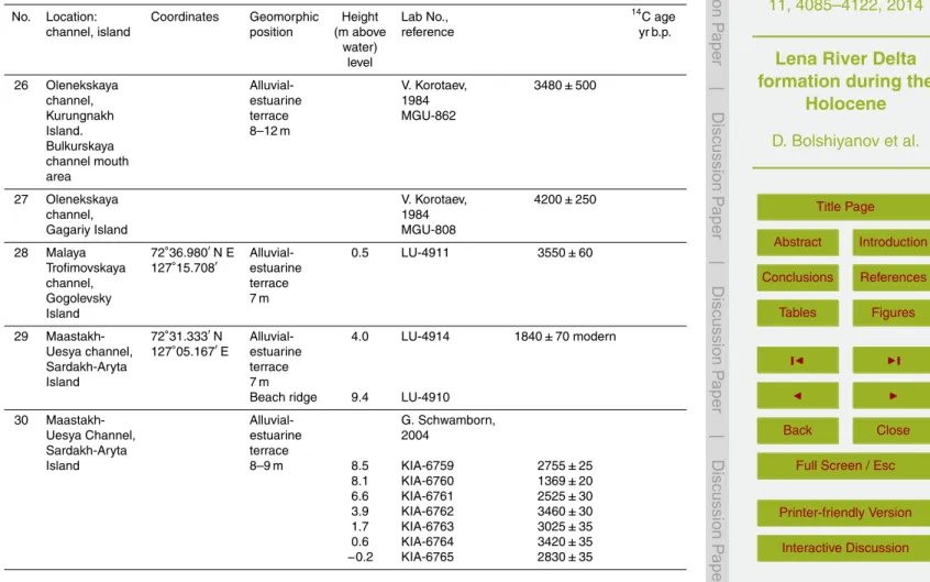
Table 1.Radiocarbon dates of the Holocene Lena Delta sediments.
No. Location: Coordinates Geomorphic Height Lab No., 14C age
channel, island position (m above reference yr b.p.
water) level
1 Bolshaya 73◦
22′
17′′
N Alluvial- 3.1 LU-4201 1400±80 Tumatskaya 125◦
50′
22′′
E estuarine
channel terrace
Sagastyr Island 3–4 m height
2 Malaya 72◦
57′
09′′
N Alluvial- 2.5 LU-4191 8570
Tumatskaya 125◦
55’06′′
E estuarine
channel terrace
Chenchike-Sise 4–7 m
Island
3 Malaya 72◦
54’43′′
N Alluvial- 9.0 LU-4412 6460±100 Tumatskaya 125◦
52’30′′
E estuarine
channel terrace
Dgipiries 10–11 m on a
Island Pleistocene base
4 Malaya channel 72◦
51′
58′′
N Alluvial- 7.8 LU-4197 1880±120 Tumatskaya 125◦
55′
08′′
E estuarine Chenchike-Sise terrace
Island 9–10 m
5 Malaya 72◦
51′
14′′
N Alluvial- 7.5 LU-4198 6430±120 Tumatskaya 125◦
50′
22′′
E estuarine
channel terrace
Dgipiries-Sise 10–11 m on a
Island, Pleistocene base
northeast coast of Lake Yugus-Dgie-Kyuele
6 Malaya 72◦
49′
45′′
N Alluvial- 5.8 LU-4193 2690±100 Tumatskaya 125◦
49′
40′′
E estuarine
channel terrace
Dgipiries- 8.5–9 m 7.0 LU-4199 1320±80
BGD
11, 4085–4122, 2014
Lena River Delta formation during the
Holocene
D. Bolshiyanov et al.
Title Page Abstract Introduction Conclusions References Tables Figures ◭ ◮ ◭ ◮ Back Close
Full Screen / Esc
Printer-friendly Version Interactive Discussion Discussion P a per | D iscussion P a per | Discussion P a per | Discuss ion P a per
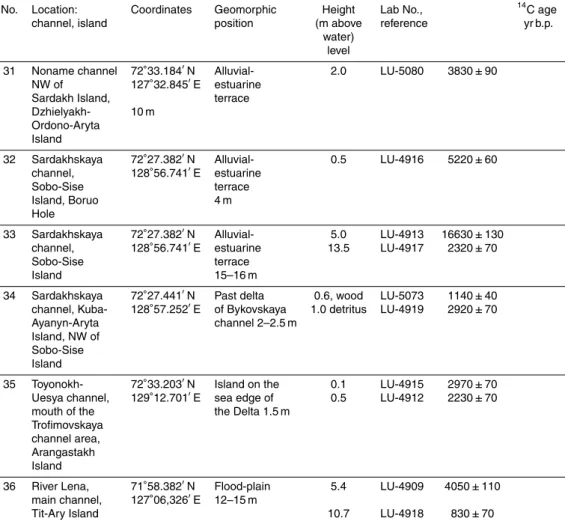
Table 1.Continued.
No. Location: Coordinates Geomorphic Height Lab No., 14C age
channel, island position (m above reference yr b.p.
water) level
7 Arynskaya 72◦
36′
50′′
N Alluvial- 5,2 LU-4413 3930±90
channel 125◦
53′
30′′
E estuarine Buor-Syr-Aryta terrace
Island 8.5 m
8 Olenekskaya Tyuyarenkey- 72◦
29′
33′′
N Alluvial- 7.6 LU-4409 6890±170
channel, 125◦
18′
45′′
E estuarine 10.7 LU-4407 6520±130
Tubelege terrace
(Gusinka), 9–13 m
Dzhangilakh-Sise Island
9 Olenekskaya Khardang 72◦
45’26′′
N Alluvial- 2.0 LU-4411 5100±140
channel 124◦
05′
26′′
E estuarine
Island terrace
5–7 m
10 Olenekskaya Khardang 72◦
48′
06′′
N Alluvial- 2.0 LU-4414 2850±200
channel 123◦
37′
28′′
E estuarine
Island terrace
4–5 m
11 Kuba Bay 72◦
55′
06′′
N Marine 1 2.5 LU-4548 1170±50 Ebe-Bsyn-Sise 123◦
57′
50′′
E terrace
Island 1.2–4 m
12 Kuba Bay 72◦
53′
31′′
N Marine 3.2 LU-4545 750±40 Ebe-Bsyn-Sise 123◦
11′
20′′
E terrace
Island 3.5 m
setup wood 4.0 LU-4547 180±50
13 Kuba Bay 72◦
53,796′
N Marine 3.5 LU-4551 3620±60 Ebe-Bsyn-Sise 123◦
10.186′
E terrace
Island 5–8.5 m
Marine 2.3 LU-4544 1220±40 terrace
BGD
11, 4085–4122, 2014
Lena River Delta formation during the
Holocene
D. Bolshiyanov et al.
Title Page Abstract Introduction Conclusions References Tables Figures ◭ ◮ ◭ ◮ Back Close
Full Screen / Esc
Printer-friendly Version Interactive Discussion Discussion P a per | D iscussion P a per | Discussion P a per | Discuss ion P a per |
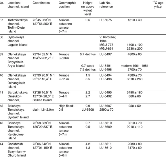
Table 1.Continued.
No. Location: Coordinates Geomorphic Height Lab No., 14C age channel, island position (m above reference yr b.p.
water) level
14 Angardam 72◦
44′
50′′
N Alluvial- 2.8 LU-4564 410±60 channel 123◦
38′
00′′
E estuarine
Kharayalakh- terrace
Ary Island 5.5 m
15 Angardam 72◦
42.813′
N Alluvial- 1.7 LU-4569 2390±50 channel, 123◦
29.970′
E estuarine
Dzhakhse- terrace
Tubelege, 5–5.5 m
Angardam Ridge bottom
16 Angardam 72◦
43.777′
N Alluvial- 0.5 LU-4541 2600±50 channel, 123◦
29.442′
E estuarine 0.1 LU-4542 790±40
Ulakhan-Ary terrace
Island 8–9 m
17 Angardam 72◦
47.353′
N Sand island −0.35 LU-4563 3400±60 channel, 123◦
07.511′
E in a channel
Olenek-Kumaga 1.7 m
sands
18 Angardam 72◦
49.531′
N Bulguniagkh 5.2 LU-4561 6020±110 channel 123◦
05.264′
E 12 m on the Belkey Island surface of 5 m
flood-plain
19 Confluent of 72◦
49.063′
N Driftwood, 4 LU-4546 220±40 Angardam 123◦
09.557′
E 4 m bottom
channel and of termokarst
Olenekskaya lake
channel, Belkey Island
20 Belkey-Aryn- 72◦
50.254′
N Alluvial- 0.9 LU-4572 1770±50 Uesya channel, 123◦
11.596′
E estuarine
Soduom-Aryta terrace
BGD
11, 4085–4122, 2014
Lena River Delta formation during the
Holocene
D. Bolshiyanov et al.
Title Page Abstract Introduction
Conclusions References
Tables Figures
◭ ◮
◭ ◮
Back Close
Full Screen / Esc
Printer-friendly Version Interactive Discussion
Discussion
P
a
per
|
D
iscussion
P
a
per
|
Discussion
P
a
per
|
Discuss
ion
P
a
per
Table 1.Continued.
No. Location: Coordinates Geomorphic Height Lab No., 14C age
channel, island position (m above reference yr b.p.
water) level
21 Samoim-Uesya 72◦
45.481′
N Alluvial- 4 LU-4568 1710±60
channel, 123◦
10.463′
E estuarine
Tyalyr- terrace
Mengenyakh- 7 m
Ary Island
22 Bolshaya 72◦
22.103′
N Alluvial- 2.5 LU-4577 3220±70
Tumatskaya 126◦
29.581′
E estuarine
channel, terrace
Samoylovsky 8.5–10 m
Island
23 Bolshaya Alluvial- G. Schwamborn,
Tumatskaya estuarine 2004
channel terrace
Samoylovsky 8.5–10 m
Island 7.5 435±30
(borehole) 6.6 KIA-8169 230±25
6.2 KIA-8170 500±25 1.3 KIA-8171 2605±30 1.2 KIA-8172 2530±30 0.4 KIA-8173 2635±35
KIA-8174
24 Bolshaya Alluvial- V. Kuptsov and
Tumatskaya estuarine A. Lisitsin,
channel terrace 1996
Samoylovsky 8.5–10 m
Island
6.2 IORAN-4167 3700±260 4.2 IORAN-4164 4220±240 3.6 IORAN-4101 2140±110 25 Olenekskaya 72◦
21.713′
N Alluvial- 7 LU-4565 540±60
channel, 126◦
19.588′
E estuarine
Arga-Bilir- terrace 3.5 LU-4609 3170±50
BGD
11, 4085–4122, 2014
Lena River Delta formation during the
Holocene
D. Bolshiyanov et al.
Title Page Abstract Introduction
Conclusions References
Tables Figures
◭ ◮
◭ ◮
Back Close
Full Screen / Esc
Printer-friendly Version Interactive Discussion
Discussion
P
a
per
|
D
iscussion
P
a
per
|
Discussion
P
a
per
|
Discuss
ion
P
a
per
|
Table 1.Continued.
No. Location: Coordinates Geomorphic Height Lab No., 14C age
channel, island position (m above reference yr b.p.
water) level
26 Olenekskaya Alluvial- V. Korotaev, 3480±500
channel, estuarine 1984
Kurungnakh terrace MGU-862
Island. 8–12 m
Bulkurskaya channel mouth area
27 Olenekskaya V. Korotaev, 4200±250
channel, 1984
Gagariy Island MGU-808
28 Malaya 72◦
36.980′
N E Alluvial- 0.5 LU-4911 3550±60
Trofimovskaya 127◦
15.708′
estuarine
channel, terrace
Gogolevsky 7 m
Island
29 Maastakh- 72◦
31.333′
N Alluvial- 4.0 LU-4914 1840±70 modern Uesya channel, 127◦
05.167′
E estuarine
Sardakh-Aryta terrace
Island 7 m
Beach ridge 9.4 LU-4910
30 Maastakh- Alluvial- G. Schwamborn,
Uesya Channel, estuarine 2004
Sardakh-Aryta terrace
Island 8–9 m 8.5 KIA-6759 2755±25
8.1 KIA-6760 1369±20
6.6 KIA-6761 2525±30
3.9 KIA-6762 3460±30
1.7 KIA-6763 3025±35
0.6 KIA-6764 3420±35
BGD
11, 4085–4122, 2014
Lena River Delta formation during the
Holocene
D. Bolshiyanov et al.
Title Page Abstract Introduction
Conclusions References
Tables Figures
◭ ◮
◭ ◮
Back Close
Full Screen / Esc
Printer-friendly Version Interactive Discussion
Discussion
P
a
per
|
D
iscussion
P
a
per
|
Discussion
P
a
per
|
Discuss
ion
P
a
per
Table 1.Continued.
No. Location: Coordinates Geomorphic Height Lab No., 14C age
channel, island position (m above reference yr b.p.
water) level
31 Noname channel 72◦
33.184′
N Alluvial- 2.0 LU-5080 3830±90
NW of 127◦
32.845′
E estuarine Sardakh Island, terrace Dzhielyakh- 10 m
Ordono-Aryta Island
32 Sardakhskaya 72◦
27.382′
N Alluvial- 0.5 LU-4916 5220±60 channel, 128◦
56.741′
E estuarine
Sobo-Sise terrace
Island, Boruo 4 m
Hole
33 Sardakhskaya 72◦
27.382′
N Alluvial- 5.0 LU-4913 16630±130 channel, 128◦
56.741′
E estuarine 13.5 LU-4917 2320±70
Sobo-Sise terrace
Island 15–16 m
34 Sardakhskaya 72◦
27.441′
N Past delta 0.6, wood LU-5073 1140±40 channel, Kuba- 128◦
57.252′
E of Bykovskaya 1.0 detritus LU-4919 2920±70 Ayanyn-Aryta channel 2–2.5 m
Island, NW of Sobo-Sise Island
35 Toyonokh- 72◦
33.203′
N Island on the 0.1 LU-4915 2970±70 Uesya channel, 129◦
12.701′
E sea edge of 0.5 LU-4912 2230±70 mouth of the the Delta 1.5 m
Trofimovskaya channel area, Arangastakh Island
36 River Lena, 71◦
58.382′
N Flood-plain 5.4 LU-4909 4050±110 main channel, 127◦
06,326′
E 12–15 m
BGD
11, 4085–4122, 2014
Lena River Delta formation during the
Holocene
D. Bolshiyanov et al.
Title Page Abstract Introduction
Conclusions References
Tables Figures
◭ ◮
◭ ◮
Back Close
Full Screen / Esc
Printer-friendly Version Interactive Discussion
Discussion
P
a
per
|
D
iscussion
P
a
per
|
Discussion
P
a
per
|
Discuss
ion
P
a
per
|
Table 1.Continued.
No. Location: Coordinates Geomorphic Height Lab No., 14C age
channel, island position (m above reference yr b.p.
water) level
37 Trofimovskaya 72◦
45.963′
N Alluvial- 0.5 LU-5075 1510±40
channel, 127◦
56.252′
E estuarine
Trofim-Diete terrace
Island 6–7 m
38 Bykovskaya V. Korotaev,
channel 1984
Lagutin Island MGU-773 1400±100
MGU-861 2530±200 39 Olenekskaya 72◦
34′
52.5′′
N Terrace 0.7 detritus LU-5497 4800±80 channel 124◦
56.02,7′′
E 8–10 m
Batyyalakh-Aryta Island 0.7 wood LU-5491 modern 1961–1981
7.5 detritus LU-5498 2700±70 40 Olenekskaya 72◦
30′
20.9′′
N 1 Terrace 1.5 LU-5494 4380±70
channel, 25◦
17.10,4′′
E 9–11 m 8.5 LU-5496 3610±260
Dzhangilakh Island
41 Sardakhskaya 72◦
38′
16.5′′
N Terrace 2.2 LU-5495 3490±180
Omsukor- 127◦
34.28,0′′
E 3–4 m 2.7 LU-5492 880±60
channel, Belkee Island
42 Bolshaya High flood- 0.9 LU-5607 950±50
Tumatskaya plain 1.6–2.0 m 0.5 LU-5608 2590±70 channel,
Syrdakh Island
43 Bolshaya 72◦
58.889′
N Alluvial- 0.7 LU-5610 3210±70
Tumatskaya 126◦
29.837′
E estuarine 0.5 LU-5609 9010±110
channel, terrace
Kerdiepime 5–7 m
Island
44 Osokhtokh 73◦
06.642′
N Alluvial- 4.2 LU-5611 2280±80
channel, 127◦
01.159′
E estuarine 1.3 LU-5612 3170±60
Bezymianny- terrace